
Abstract
This paper approaches the floods of 2015 in Chennai, Tamil Nadu, India, as the consequence of policies, plans and procedures that, over many years, had erased monsoon water and wetness from the city and its imaginary. In order to do this, it examines a number of plans that authorized spatial development in Chennai from the early 20th century onwards. It approaches them as urban cosmograms, in which heterogeneous entities were accommodated, congealed, concealed or expelled in the description of the urban territory and the composition of the urban world. The paper undertakes this analysis in order to deepen understanding of the relations between spatial planning, capitalist urbanization and the more-than-human vitalities of the monsoon. It approaches the flood waters that rose and fell in 2015 as a cosmopolitical situation and cause for thinking, which, putting people in the presence of the monsoon and its potency in new ways, forced them to confront the precariousness of their co-existence with it and experiment with ways to re-compose the urban monsoonal world differently. This discussion draws from Stenger’s notion of cosmopolitics as a mode of collective practice that proceeds in the company of those who would otherwise be likely to be disqualified as having idiotically nothing to propose, including the more-than-human. The paper makes some critical observations about these experiments and concludes by speculating on whether planning itself might be envisaged as a more inclusive, cosmopolitical project.
Introduction
As my airplane approached Chennai on 14 November 2015, the sky was dark and heavy with clouds, the air was grey and visibility was limited. As we descended and the landscape began to become visible through the fog, all I could see was a vast, seamless expanse of stagnant, dirty-grey water dotted with vegetated hilltops. As we drew closer to the city, the scene began to gain more definition. Linear expanses of water designating roads started to appear, buildings began to push above the water and, as the city densified, the ratio of water to ground tipped. But wetness was still everywhere, hanging in the air, coating buildings, saturating the earth. More rain followed until 1049 millimetres of rain had fallen that month. Then on 1 December another torrential deluge brought between 280 and 490 millimetres to various parts of the city and up to 600 millimetres further inland. On 2 December, state authorities opened the sluices of the Chembarambakkam Tank, one of the city’s drinking water reservoirs, releasing a further 821 cubic metres per second into the city for 12 hours. The results were catastrophic. One hundred and sixty-five of Chennai’s 200 wards were under water; the Chennai International Airport was closed and trains were cancelled. Schools too were closed and examinations postponed. The Government of India declared Chennai a disaster zone. By 4 December flood waters had begun to recede and important roads were reopened, but 40% of the city remained submerged. Two days later the airport was reopened, rail services slowly resumed and mobile, power and banking services were partially restored. By the end of December, most flood waters had receded, schools were back, hospital services had been restored and a semblance of normality had returned (Narasimhan et al., 2016).
As the floodwaters rose and receded, two versions of the flood’s onto-politics emerged. On the one hand, politicians were quick to invoke the authority of science and past records to claim that the rains had been an exceptional natural anomaly. Tamil Nadu Chief Minister Jayalalithaa referred to satellite animations generated by NASA, declaring the event to be ‘unprecedented, catastrophic and cataclysmic’ (Janardhanan, 2015b). Indian Prime Minister Modi called it a ‘calamity of severe nature’ (PTI, 2016) and the Indian delegation in Paris for COP 21 declared that the floods were caused by climate change (Selveraj et al., 2015). As Arabindoo (2016) has pointed out however, a more nuanced reading of the historical record indicates that while the amount of rain that fell in Chennai in 2015 was excessive, it was not unprecedented. Depressions, storms and cyclones are a frequent, if not an annual occurrence in Chennai, given that it lies on the high-energy coast of the Bay of Bengal. Instead, the exceptionalism pronounced by the authorities was a political ploy with a feigned connection to science to mobilize resources for relief efforts tied to patronage politics and to reassure real estate markets and business investors (Wyatt, 2013). The other version of the floods that emerged was that they were a consequence of lax urban planning and unregulated development (Jayaraman, 2015; Ramanathan, 2015; Rekha et al., 2015). Over time, encroachments on urban water bodies and natural drainage channels by high-value real estate had reduced the water holding and drainage capacities of the city (Shekhar and Thomas, 2015). The floods, in other words, were a conjugation of human and nonhuman factors that included planning and land use (Ramanathan, 2015). This version of the floods was endorsed in a report by the Comptroller and Auditor General of India (2017) who proclaimed the 2015 floods a human-made disaster and held the government of Tamil Nadu responsible for the scale of the catastrophe.
It is the second version of the floods that this paper subjects to further scrutiny. It adds to a growing literature on the 2015 floods, including papers by Shekhar and Thomas (2015), Jameson and Baud (2016) and Arabindoo (2016). Shekhar and Thomas (2015: 19) argued that the floods were a ‘wake-up call’ to scholars and activists to examine how real estate had ridden roughshod over the city’s water bodies. This had been facilitated by an administration that not only tweaked and modified urban plans and building rules in favour of real estate but it also frequently broke those rules itself (see also Rekha et al., 2015). The authors proposed that a new map of the city be drawn up to hold official narratives to account, overlaying topography, ecology, drainage networks, flood related damage to life and property and the extent of planning and building violations. This was a significant move in that it acknowledged the floods as an affective event that could produce new demands on cartography and politics. The call to remap the city has to a limited extent been taken up by Seenirajan et al. (2017) and Ahmed and Kranthi (2018). Jameson and Baud (2016) drew on an assemblage perspective (McFarlane, 2011a) to trace the knowledge construction practices of two networked flood management infrastructures – storm water drains and erys (the traditional water retention system of linked rain water tanks in Tamil Nadu). The first was embedded in government knowledge systems and networks, the latter in counter mappings by NGOs and academic activists. The authors proposed that linking these two knowledge systems into what Stengers would call an ‘ecology of practice’ (Shaviro, 2005) would reinvigorate integrated water resource management as a context-specific concept and contribute to reducing the city’s flood risks and water scarcity problems. While sharing Jameson and Bauds’ assemblage perspective, this paper approaches the floods not as a water resource management issue, but as what Stengers (2005: 994) called a ‘cosmopolitical proposal’. By this she meant as an opportunity for redesigning collective thinking in such a way that it proceeds ‘in the presence of those who would otherwise be likely to be disqualified as having idiotically nothing to propose’, including the more-than-human (Stengers, 2005: 1002). Arabindoo’s (2016) paper argued that tagging the floods as social (Smith, 2006) was not enough to unravel the complex spatial and environmental histories behind them. She followed Gotham and Greenberg (2014) in linking disaster studies and urban studies and argued that the social forces that produced systemic risk and vulnerability were embedded in a long genealogy of capitalist urbanization. While agreeing with this critique, this paper shifts its human centred vocabulary to a vocabulary of more-than-human agency (Bennet, 2010) and cosmopolitics (Farias and Blok, 2016).
The focus of this paper is spatial planning. It brings an assemblage perspective (Farias and Bender, 2010; McFarlane, 2011a; Farias and Blok, 2016) to bear on the plans and procedures that authorized the spatial trajectory of Chennai from the early 20th century onwards. It does so to deepen understandings of the relations between spatial planning as a socio-political instrument, capitalist urbanization and the more-than-human vitalities of the monsoon. The paper approaches Chennai’s urban plans and planning procedures as ontological instruments and shows how over time these became dominated by real estate interests (Frontline, 2018). They abandoned the bonds that connected them to the earth (Beauregard, 2015), ‘forgetting the world of things themselves, the sand, the water, the mud, the reeds of the marsh’ (Serres, 1995: 2). In this context, the 2015 floods were an affective event (Whatmore, 2013) that put people in the presence of the monsoon in new ways and forced them to confront the precariousness of their co-existence with its force. Since then a number of cosmopolitical experiments have been initiated that challenge expert reasoning and arouse different approaches to the problems and situations that the floods exposed. After discussing the history of spatial planning in Chennai, the paper surveys these post-flood initiatives.
The paper was prepared as part of a wider research project on the monsoon in south Asia. Its preparation included a review of theoretical literature and secondary sources on the Chennai floods including academic papers, scientific reports, grey literature and media articles. Archival research was carried out in the British Library and the libraries of IIT Madras and the Anna University School of Architecture and Planning to source historic planning documents and related literatures. The author visited Chennai three times between November 2015 and August 2017, the last of which was a seven-week period of field work. During these visits, interviews were conducted with academic experts, meteorologists, built environment professionals, real estate developers, city administrators, urban activists and community representatives, informing the arguments developed in the paper. In addition, wetlands, water tanks, storm water infrastructure and housing developments were visited in order to better understand the vitality of water and wetness in the city.
Before proceeding with the main argument of the paper, the conceptual vocabulary it draws from will be sketched out.
Assemblages, cosmopolitics, cosmograms
Assemblage theory was introduced into urban studies by Farias and Bender’s (2010) book Urban Assemblages: How Actor-Network Theory Changes Urban Studies. This generated debate in CITY journal between assemblage and critical approaches, with Brenner et al. (2011) advocating a critical theory position and rejoinders from Farias (2011) and McFarlane (2011a). Assemblage perspectives challenged critical readings of cities that reduced them to the workings of capital and introduced ‘multiplicities of life worlds that persistently have ambivalent relations with capital formation’ (Anand, 2017: 6) into urban studies. In approaching cities in this way, a number of methodological principles from actor-network theory were carried into urban studies (Farias, 2010, 2011). The first was that cities are more-than-human productions and that the more-than-human is part of urban becoming (Whatmore, 2013). The second was that assemblages are radically relational. Here Latour’s (2007) version of assemblages as extended networks of associations and Tsing’s (2015: 292) version of assemblages as ‘what gathers in a place’ are both pertinent to the study of the urban (McFarlane, 2011b; Wang et al., 2016). The third principle was that analysing assemblages can only proceed if adopting what Callon (1986) called the principle of generalized symmetry, i.e. the application of a ‘common conceptual repertoire’ (Farias, 2010: 3) to all components of an assemblage. One component cannot be treated materially and another metaphorically for instance. Here Ranganathan’s (2015) approach to storm water drains in Bangalore, in which concepts of fixity and flow are applied literally to storm water drains and metaphorically to capital becomes problematic.
Approaching urban politics from an assemblage perspective has adopted object-centred, ontological and cosmopolitical perspectives (Whatmore, 2013; Farias and Blok, 2016). The first, Latour’s Dingpolitik (2005) followed pragmatist political thought (Dewey, 1927; Lipmann, 1922) to turn politics around shared matters of concern. It did not point to structurally determined conflicts or clashes between social groups but to the ‘irruption of ontological and epistemic uncertainties, whose resolution involves the invention of new political arrangements’ (Farias and Blok, 2016: 7). Ontological politics (Moll, 1999) refers to the political processes through which cities are enacted into being as contested sites of relationality, not as instantiations of broader structural processes. Cosmopolitics, as conceived by Latour (2004a) and Stengers (2005), is a political project attuned to those whose voices are likely to be disqualified as having nothing to offer to collective thought, including ‘the multiplicity of more than human inhabitants that make themselves at home in the city’ (Hinchcliffe and Whatmore 2006: 124). It opens politics up to the diversity of the world and to the existence of all the entities that compose it. This cosmopolitical proposal takes issue with the idea of expert knowledge and with the Kantian idea of cosmopolitanism associated with ideas of world peace and world citizenship (Beck, 2002). For cosmopolitical practitioners, confidence in science as neutral, universal knowledge and the cosmos as a stable, external certainty on which world citizenship can be based has evaporated. Instead, the cosmos is something that has to be politically instigated and composed, often with radically indifferent or incommensurable entities (Stengers, 2015; Farias, 2016; Yaneva and Zaera-Polo, 2016).
In their book Urban Cosmopolitics Farias and Blok (2016) propose that cosmopolitical approaches to the urban be framed by three ideas – agencements, assemblies and atmospheres. Agencements (Deleuze and Guattari, 1980) are the material–semiotic–technological instruments through which urban worlds are arranged. These include plans, rules, infrastructure, urban agencies, etc. and their effects (power, inequality, solidarity, justice, co-existence etc.). Assemblies are the sites and processes through which urban concerns, constituencies and publics are gathered (McFarlane, 2011a), while the concept of atmospheres invokes the boundaries and separations necessary to maintain the material conditions of urban life in the presence of ‘inhuman nature’ (Clark, 2011). This term refers to the agencies and powers of the earth (Gross, 2012) that are utterly indifferent to human and nonhuman life (Stengers, 2015) and have the capacity to undo sustaining connections and footings (Clark, 2011). While there is a growing acceptance in social thought that human becoming includes the more-than-human and that the human animal is part of nature (Whatmore, 2013), there is also growing awareness that the earth has lethal inhuman powers that are indifferent to attempts to negotiate with them (Clark, 2011). Questions of the radical incommensurability of geo with bio (Whatmore, 2013) are thus introduced into urban cosmopolitics (Farias, 2016).
These literatures and concepts have informed the paper’s approach to the monsoon and the history of planning in Chennai. The paper treats the monsoon as an inhuman, though necessary participant in urban life. It analyses plans as agencements (Deleuze and Guattari, 1980) or cosmograms (Tresh, 2007) for arranging urban life, including monsoonal matter–energy. The term cosmogram refers to ‘a class of things that humans make to represent the universe as a whole, to show how it works and fits together’ (Tresh, 2015). While cosmograms take many forms, what unites them is that they are performative, operative models to assemble and establish social order by presenting a picture of the whole and how it fits together. Through the idea of ‘cosmopragmatics’ (Tresch, 2013: online), the paper discusses six plans for Chennai, examining what agencies, drawings and protocols produced them; what counted enough to be included in them and what did not; what changes they brought about and what effects they had on the presence of monsoonal materiality in the city. The plans discussed are H. V. Lanchester’s Madras Town Improvement Scheme (Lanchester, 1918), the World Bank’s First Madras Urban Development Project (World Banks Urban Projects Department, 1977), the Madras Interim Plan (Tamil Nadu Directorate of Town Planning (TNDTP), 1967), the Madras Metropolitan Plan (Tamil Nadu Rural Development and Local Administration Department, 1971a), the First Madras Master Plan (FMMP) (Tamil Nadu Rural Development and Local Administration Department, 1971b) and the Second Chennai Master Plan (SCMP) (Chennai Metropolitan Development Authority, 2008). The paper then turns to the ways in which the 2015 floods ‘forced thought’ (Whatmore, 2013: 34) amongst the people affected by them and occasioned the formation of new collectives gathered around Chennai’s water bodies, to re-compose urban-monsoonal worlds differently. It discusses aspects of these cosmopolitical experiments and concludes by speculating on whether planning itself might be envisaged as a more inclusive, cosmopolitical project.
Rearranging the monsoon
The Madras Town Improvement Scheme, 1918
Chennai lies on the southeastern coastal plain of India, a low-lying landscape of rivers, sand dunes, backwater lakes, wetlands and salt pans. It was founded in 1639 by way of a 10 square kilometres grant of land on a coastal spit by Darmala Venkatapati Nayak to Francis Day of the East India Company. The land grant was contained within the traditional limits of the village of Madraspatnam and was surrounded by several ancient settlements with the typical characteristics of south Indian towns. Each was dominated by a temple and its adjoining rain water tank, surrounded by commercial activities and residential neighbourhoods in a concentric pattern (Madras Tercentenary Publication Committee, 1939). The villages were separated from one another by scrubland, wooded groves, wetlands, paddy fields and rain water tanks (Murali, 2003).
Rainfall departures from normal in Tamil Nadu, 1870–2010.
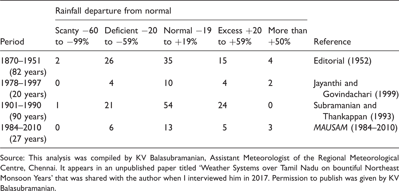
Source: This analysis was compiled by KV Balasubramanian, Assistant Meteorologist of the Regional Meteorological Centre, Chennai. It appears in an unpublished paper titled ‘Weather Systems over Tamil Nadu on bountiful Northeast Monsoon Years’ that was shared with the author when I interviewed him in 2017. Permission to publish was given by KV Balasubramanian.
Prior to the early 20th century, no systematic attempts at town planning had been undertaken in colonial India. However, a widespread plague epidemic in 1909 resulted in the Government of India embarking on initiatives to improve the organization of Madras, Bombay and Calcutta, its main urban centres. These initiatives began with an All India Sanitary Conference in Bombay in 1911 (Superintendent Government Printing, 1912). Here the newly formulated science of town planning was advanced as the way to address the problems of overcrowding and inadequate drainage and sanitation that had been identified as responsible for the plague (Porter, 1912). Town planning had emerged in Britain in the late 19th century city as an instrument of social reform. It promoted good city form as the basis of a healthy society. It constructed cities as objects of scientific knowledge through socio-spatial surveys and applied geometric rules derived from precedent as the way to plan urban space (Sandercock, 2003). Its connections to the material context in which it operated were tenuous and nature was constructed as inert and external to society (Beauregard, 2015). If threatening to the social order, nature was to be brought under the control of the plan through the application of science and engineering.
These ideas permeated the approach to town planning introduced in Madras after the All India Sanitary Conference. Lord Pentland, Governor of Madras, invited Scottish town planner Patrick Geddes to advise him on improving urban conditions in the Presidency. On Geddes’ advice, Pentland appointed HV Lanchester, a founding member of the British Town Planning Institute, as town planning advisor. Lanchester was commissioned to undertake a comprehensive survey of the towns of the Madras Presidency, to lay down their future lines of growth and development and to train officials in city government in planning (Tyrwhitt, 1947). This resulted in the book Town Planning in Madras: A Review of the Conditions and Requirements of City Improvement and Development in Madras (Lanchester, 1918). In this treatise, Lanchester (1918: 42) constructed an idea of the city of Madras as unhealthy, with a ‘tendency to overcrowding’ and whose flat terrain ‘rendered drainage difficult’ (102). He proposed that by ‘weeding out’ congested dwellings (Lanchester, 1918: 57), expanding the city along axial extensions, building detached rather than row housing and developing sanitation and drainage infrastructure, living conditions in the city would be improved.
Gonzales Vives (2016) and others before her (Illich, 1985; Kaika, 2005) have argued that moderns have generally mistrusted water, and considered dehydrated environments optimal for human health. Beginning in the 19th century, industrial cities began to be designed as ‘waterproofed machines’ (Gonzales Vives, 2016: 332). Earthworks and drainage systems ‘de-watered the territory of the city, followed by the construction of an extensive and watertight carpet… that hid the thickness of the soil and erased water from the urban map’ (Gonzales Vives, 2016: 332). Madras, a coastal city on low-lying land laced by seasonal rivers, backwater lakes, wetlands and paddy fields, where ground water lay close to the surface even in dry seasons, presented particular problems in this regard. It was irrigated by linked systems of shallow water tanks (or erys) and distributing channels organized not to drain, but to retain and utilize almost all the water falling on them. As the city grew, maintenance of this system had deteriorated and water accumulated in what Lanchester (1918: 91) referred to as ‘undesirable places’. Tanks were seen to afford ideal breeding conditions for mosquitoes, recently identified as the carriers of malaria. A sanitary report in Lanchester’s book indicated a strong aversion to the city’s seasonal wet/dryness, associating it with noxious fumes and disease. There are also many low lying places full of water during part of the year and during the other portion dry; these are used for many purposes, such as washing cattle, clothes etc. and thus while they are drying up, poisonous matters are evaporated into the air and when dry, they send forth from their beds the exhalation of the solid filth collected during the rainy season. (Jones in Lanchester, 1918: 102)
Town Planning in Madras contained a series of proposals for the city of Madras, of which two are pertinent to this paper. Plate MIX, ‘Madras Town Improvement Scheme’ (Figure 1), shows a series of circular and radial roads superimposed over the existing urban layout. A road extends the city westwards across the Long Tank, a large water body that had previously defined its western limit. The tank’s edge, in reality a seasonally fluctuating zone, is fixed by the line of a crescent shaped road. The plan’s legend identifies ‘Areas for kutcha building’ (referring to buildings of flimsy construction) and ‘Open spaces (including tanks)’. Most of the kutcha building land is located on the outer edge of the city in close proximity to water tanks, and water tanks are depicted with the same hatching as open space, making them indistinguishable from one another. Reading this against Plate MXIII, ‘Madras Town Public Ownership’ (Figure 2), one sees that land adjoining water tanks and water tanks themselves are proposed to be brought under public ownership, including part of the Long Tank.
Plate MIX: Madras Town Improvement Scheme. Source: Lanchester (1918). Plate MXIII: Madras Town Public Ownership. Source: Lanchester (1918).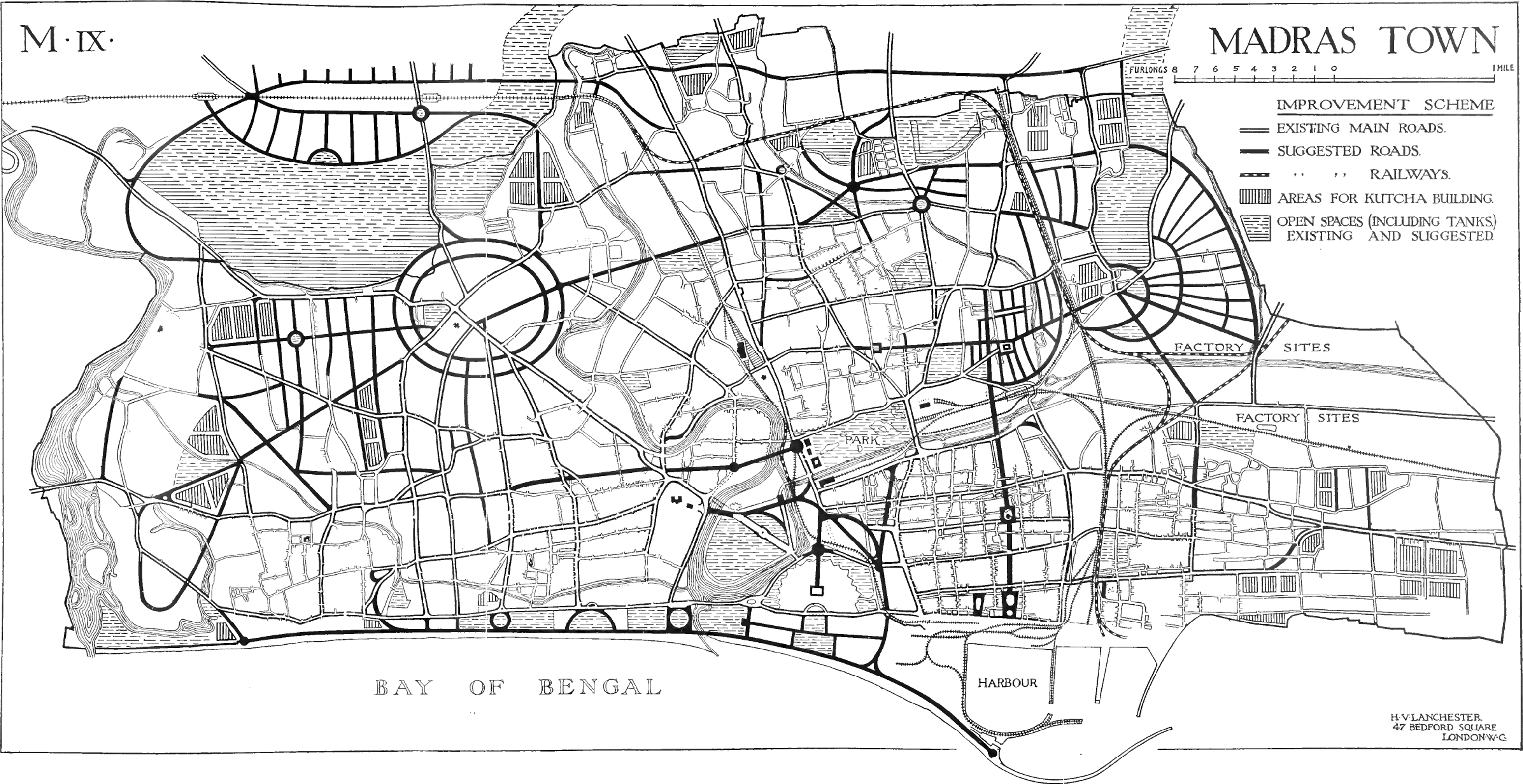
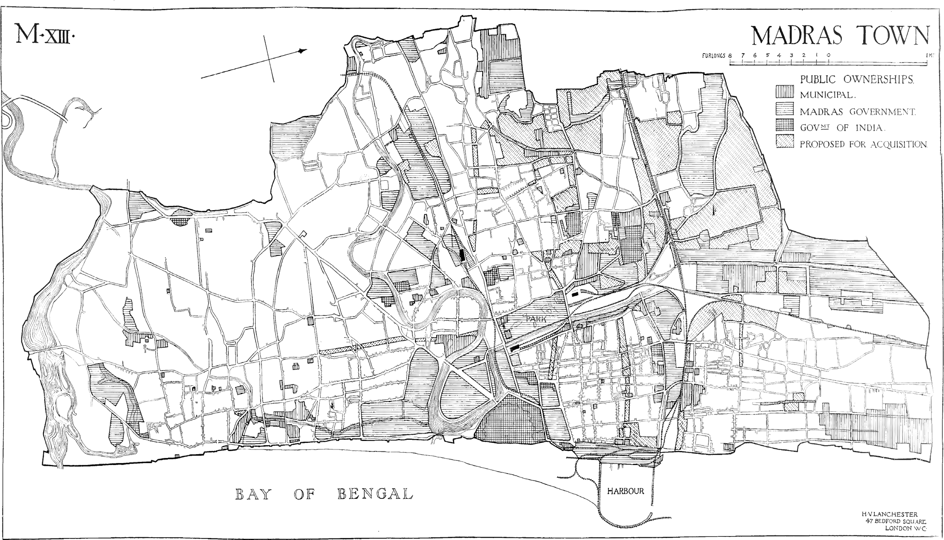
The Lanchester plan for Madras was never approved or legislated, but as an urban cosmogram, it had considerable influence on the imaginations of politicians and administrators and on the city's future trajectory. It played a large part in formulation of the Madras Town Planning Act of 1920 (Madras Presidency, 1916) which included urban issues in public policy in the Presidency for the first time. Its assemblage of health and sanitation discourse, compositional rules, social science and the view that the presence of water and wetness in the city was nothing more than pestilence, influenced attitudes to water in subsequent plans for the city. In 1923 for example, the Justice Party decided to drain the Long Tank and convert it into a planned residential colony. This produced the Mambalam Housing Scheme (Madras Town Planning Trust, 1923), later renamed Thyagaraya Nagar or T. Nagar after one of the Justice Party’s founders. In homage to Lanchester’s plan, the new suburb was laid out in radial fashion around a central open space named Panagal Park. Neighbouring Saidapet Municipality accused the Madras Corporation of encroachment and of grabbing new areas for profit, but the Corporation argued that the scheme was necessary ‘to relieve congestion in Madras and in the interest of public health and sanitation’ (Madras Town Planning Trust, 1923: 5). Lanchester’s proposal to earmark land for kutcha building (i.e. for the urban poor) on the urban periphery in close proximity to water tanks, and that water tanks and the land adjoining them be brought under public ownership also had considerable influence on future policy. The World Bank site and service schemes implemented in the city from 1977 onwards, also known as the ‘eri schemes’ were significant milestones in this history (Coelho and Raman, 2013).
Rehousing the poor
The World Bank Eri Schemes, 1977–1997
In 1969, the Madras Corporation took a decision to ‘explore avenues for securing financial assistance for the development of the city from institutions both national and international’ (Tamil Nadu Rural Development and Local Administration Department, 1971a: xi). This was at a time when the World Bank was beginning to fund urban sector projects (Cohen, 1983). As a result, a series of interactions between the World Bank and the Governments of India and Tamil Nadu took place, leading to the signing of the First Madras Urban Development Project (MUDP 1) in June 1977. The project was one of the World Bank’s earliest urban sector projects globally and the second credit for urban development in India, following the Calcutta Urban Development Project of 1973 (Pugh, 1990). It was also the first of a number of projects in Madras to realize the World Bank’s ‘technocratic neo-liberal’ (Raman, 2011: 77) model of governance reform through deregulation of markets, privatization of municipal services and cost recovery. Instead of the earlier language of health, sanitation and dehydration, the project was framed in the language of economic growth and sustainability (International Development Association, 1977; World Bank Urban Projects Department, 1977). It was formulated according to statistical formulae such as plot size, income level, return on investment, etc. by World Bank consultants with limited knowledge of the city’s geophysical or socio-political ontologies. The only registration of the monsoon in its calculations was as an economic indicator: ‘a bad monsoon, which is likely to occur about two years out of every five, has a pervasive influence over the entire economy’ (International Development Association, 1977: 1), and, in reference to Madras’ water deficiencies, that drought in 1974/5 had caused water supplies in the city to dwindle to less than 10 litres per consumer per day (World Bank Urban Projects Department, 1977). In this cosmology, the monsoon was reduced to a numerical indicator and its material vitalities and their consequences for urban space and life otherwise ignored.
MUDP 1 covered six sectors, the principal ones being shelter, transport and water supply, all of which were approached as economic opportunities. In the shelter sector, the Bank sought to radically alter Tamil Nadu housing policy, which was linked at the time to patronage politics. Existing policy focused on in situ tenement construction, delivered by the politically controlled Tamil Nadu Slum Clearance Board (TNSCB) as a way of courting votes (Raman, 2011). The World Bank sought to replace this model by imposing one of cost recovery and tenure, based on relocating slum-dwellers to site and service schemes on the urban periphery (Raman, 2011), the standards of which depended on the ability and willingness of the poor to pay for them (Hasan and Vaidya, 1986; Huchzermeyer, 2004). The sites identified for the site and service schemes in MUDP 1 were in Arumbakkam, Villivakkam and Kodungaiyur (Figure 3). Two of these (Villivakkam and Kodungaiyur) were beyond Madras’ urban boundary, while Arumbakkam lay just inside the city limits adjacent to the Madras Corporation’s sewage farm. The projects were delivered not by the TNSCB, but by the less politically controlled Tamil Nadu Housing Board (TNHB) (Raman, 2011). All three were sited on former water tanks (Owens et al., 2016; World Bank, 1986). The rationale given for this was that it reduced costs and avoided the lengthy legal procedures that the public sector had to comply with when acquiring privately owned land. This was acknowledged however as having posed ‘serious and unanticipated procedural difficulties, relating to water rights, in securing their transfer’ and that in some cases, inadequate attention had been paid to land contours (leading) to serious drainage problems and perhaps even flooding during the monsoons (as the site visits were made during the dry season there was then no problem with drainage). (World Bank, 1986: 44)
Madras Urban Development Project 1. Sites and services components at Kodungaiyur, Arumbakkam and Villivakkam. Source: World Bank Urban Projects Department (1977).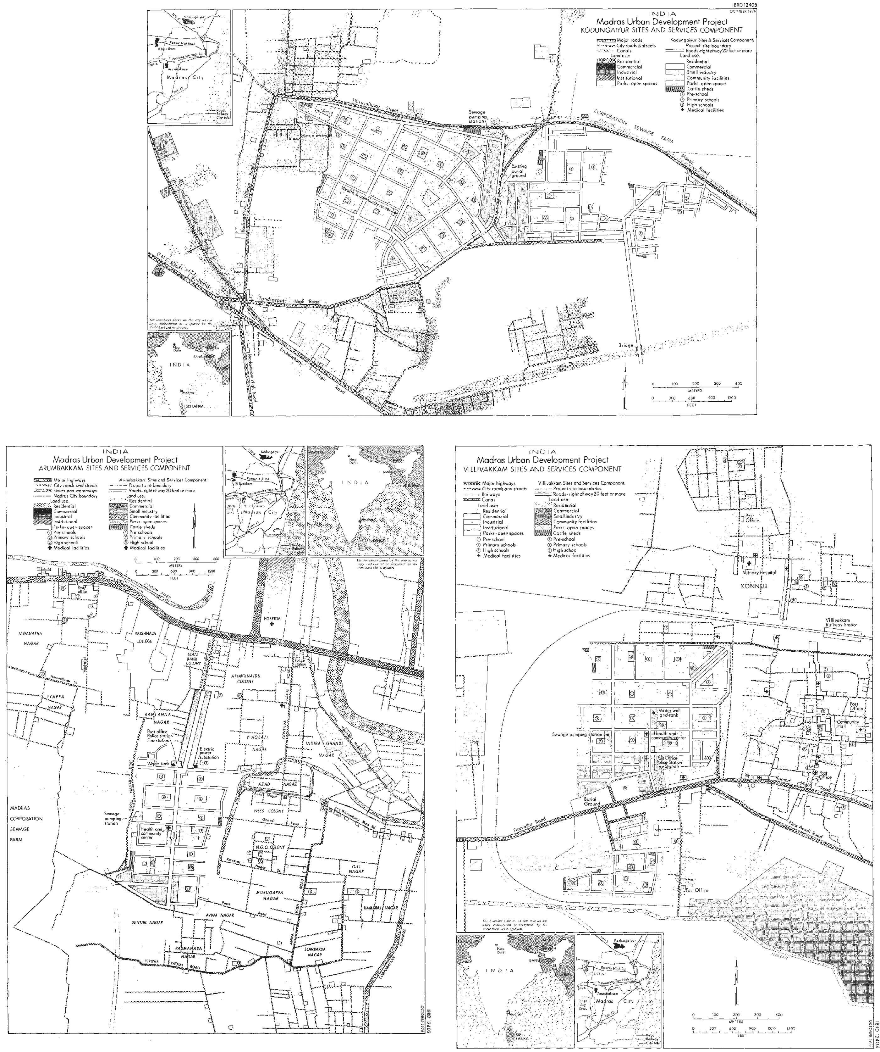
MUDP 1 was only partially successful in its ambitions, a failure the World Bank attributed to Tamil Nadu patronage politics (World Bank, 1986). Nevertheless, the project was seen as an ‘auspicious start’ (World Bank, 1986: iv) to the Bank’s involvement in Madras. It resulted in two further projects that incorporated sites and services components – The Second Madras Urban Development Project (1980–1988) and The First Tamil Nadu Urban Development Project (1988–1997). Together these projects delivered 57,000 serviced plots on 13 sites in and around the city (Owens et al., 2016). These projects all promoted economic logics as the basis of development and encroached on water tanks or their catchment areas. These encroachments normalized the view that seasonal water bodies on the urban periphery were unencumbered land and validated the policies that appropriated them for housing the urban poor. In addition to the brutal impact these policies had on the lives of those relocated to peripheral sites (Coelho and Raman, 2013), they ignored the seasonal vitality of the monsoon and the contribution the tanks made to the city’s hydrological performance by retaining water, replenishing aquifers and mitigating monsoonal excesses (Jayaraman, 2015). Yet these practices continue. The TNSCB continues to build large scale tenement colonies on peripheral low-lying wetlands and to use disasters, city beautification and river restoration projects as pretexts for expelling the urban poor to them (Coelho and Raman, 2013, 2010; Viswesaran, 1988). Here citizens routinely face flooding during rainy seasons and they were amongst the worst affected during the 2015 floods (Coelho, 2016).
Reforming planning
Madras Interim Plan, 1967; Madras Metropolitan Plan, 1971 and the First Madras Master Plan, 1976
In addition to building infrastructure, the World Bank projects for Madras included initiatives to reform institutions and policies in line with its neoliberal agenda. The projects played a strong role in institutionalizing these reforms in Tamil Nadu, in particular via the TNSCB, the TNHB and the Madras Metropolitan Development Authority (MMDA) (Madras Institute of Development Studies, n.d.). In this section, I will focus on the reforms to the planning function that were part of this package, arguing that they were responsible for further disruption to patterns of urban co-habitation with the monsoon.
Until 1971 the Madras Corporation had legal responsibility for the planning of the city, as authorized by the Madras Town and Country Planning Act of 1920 (Madras Presidency, 1916). It had been required to submit a general town planning scheme to the state government by not later than 1934, but only did so in 1957. The TNDTP (1967) rejected the scheme as inadequate and then itself, with financial assistance from the Government of India, produced the Madras Interim Plan. The monsoon was integral to the formulation of this plan. The city was described as having a tropical maritime monsoon climate, with distinct seasonal differences in temperature, humidity, wind and rainfall and susceptible to thunderstorms and cyclones. The plan made reference to the flooding events that had occurred over the previous 150 years. It took Madras’ climate and climatic history seriously and acknowledged that urban life was entangled with seasonality, unreliable rainfall and the eventfulness that came from the city’s location on the edge of the Bay of Bengal. The plan promoted development away from the coastline along historic east-west and south-west radial axes and in 10 new satellite towns further inland, retaining agricultural land between them. It acknowledged the need to retain zones of fluctuating wetness and the livelihoods that depended upon them as part of the urban system. For instance, it demarcated Ennore Creek, the tidal wetland to the north of the city, as a regional park (TNDTP, 1967). In this way, the plan enacted a form of ‘territorial cosmopolitics’ (Tironi and Cavillo, 2016: 220), laying out spatial guidelines for the co-existence of the city with monsoonal matter–energy.
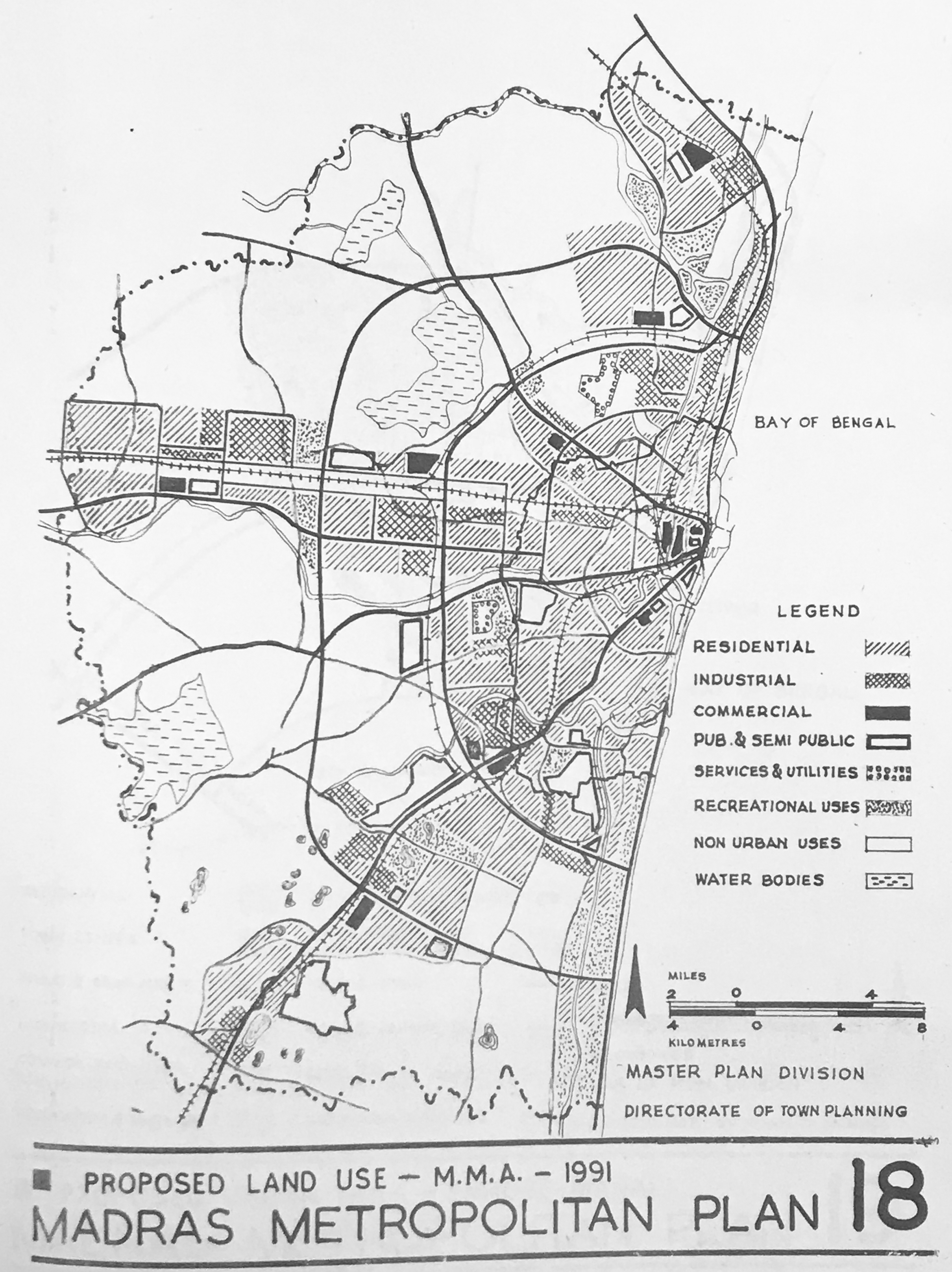
In the course of the preparation of this plan however, the TNDTP undertook a series of studies of demographics, industrial locations and traffic flows. On the basis of sociological surveys, it proposed to extend the area under consideration for planning beyond the administrative boundaries of the Madras Corporation (TNRDLAD, 1971a). In 1974 this resulted in the reformatting of Madras as a metropolitan area, comprising the Madras Corporation, 8 municipalities, 11 Town Panchayats and 179 Village panchayats in 10 Panchayat Unions in a complex assemblage of overlapping jurisdictions. This was in line with initiatives elsewhere in India, where the concept of a metropolitan area and metropolitan planning were being promoted by western consultants and Bretton Woods institutions as solutions to the demands of a growing population and unregulated development (Arabindoo, 2009; Bhan, 2016; Roy, 2002). In Madras, the Interim Plan of 1967 was rejected and the TNRDLAD (1971a) drew up a plan for the newly defined metropolitan area, the Madras Metropolitan Plan. This plan was strongly influenced by the World Bank, then negotiating MUDP 1 with the Governments of India and Tamil Nadu. It recast the objective of planning in economic terms, proposing that three existing towns outside the metropolitan boundary on radial transportation corridors – Gimmidipundi to the north, Tiruvallur to the west and Chingleput to the southwest – be expanded as economic counter magnets to Madras. Development within the metropolitan area was to be directed towards six nodes along these radial corridors and three concentric ring roads were to connect the radial corridors (TNRDLAD, 1971a). The drawings of this plan were abstract and diagrammatic, reducing the city to nodes, corridors and land use zones (Figures 4 and 5). The only water bodies shown in them were the lakes that supplied Madras with water – the Cholavaram, Red Hills and Chembarambakkam tanks. Rivers, tanks, erys, wetlands and other hydrological features of the landscape had disappeared from view. Topography and soil type were given as reasons why the city flooded during monsoons. These would be addressed through a ‘comprehensive storm water drainage system’ (TNDRDLA, 1971a: 74). The metropolitan wetlands of Kodungaiyur, Koyambedu, Nesapakkam and Pallikaranai were all earmarked as sites for sewage disposal treatment. Thus, two modernist hydrological imaginaries – capital intensive drainage-based solutions and wetlands as dump sites – were part and parcel of the metropolitanization of Madras. The Metropolitan Plan was translated into the FMMP (TNRDLAD, 1971b), approved in 1976. As well as laying out the pattern of land use and transportation corridors for the city as a whole, the FMMP served as a cosmogram or guide for public agencies to prepare sector-based plans. It came with associated zoning, land use and development control rules, which, along with local government building bylaws, served as mechanisms for its implementation (Arabindoo, 2005).
Madras Metropolitan Plan 14: Urban nodes and satellite towns. Source: Tamil Nadu Rural Development and Local Administration Department (1971a). Copyright: British Library Board, Shelfmark: Asia, Pacific & Africa W 4332. Madras Metropolitan Plan 18: Proposed Land Use – MMA – 1991. Source: Tamil Nadu Rural Development and Local Administration Department (1971a). Copyright: British Library Board, Shelfmark: Asia, Pacific & Africa W 4332.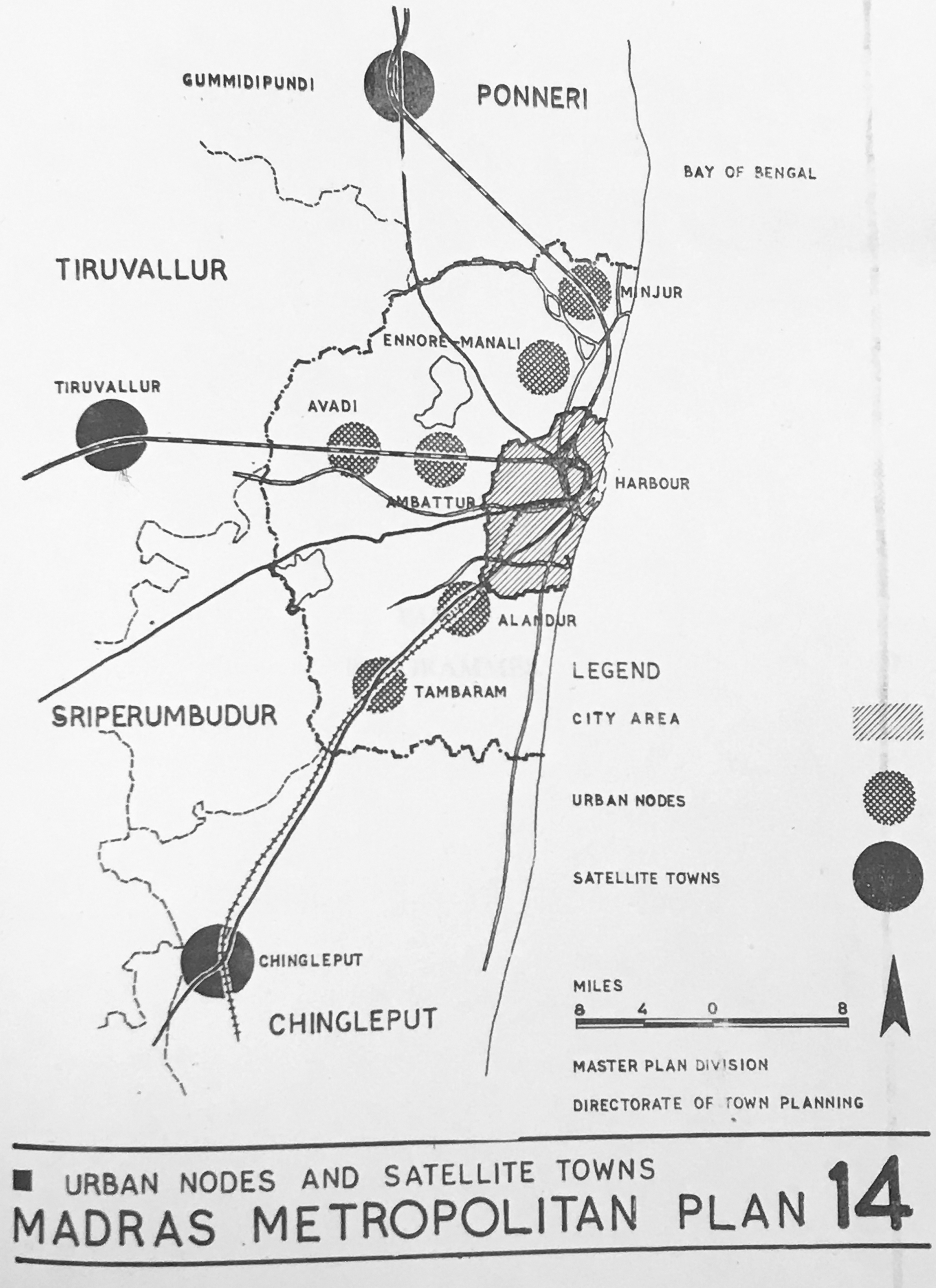
At the time of the development of the Metropolitan Plan, a restructuring of the planning function was undertaken. In 1972, the MMDA was established in the Tamil Nadu Directorate of Town and Country Planning. Its planners were trained by the World Bank and it was given unprecedented power over the development of the metropolitan area (Arabindoo, 2009), with local bodies retaining certain planning functions for their jurisdictions (CMDA, 2008). Arabindoo (2005, 2009) suggests that the chief effect of this metropolitanization of planning in Madras, as in Calcutta (Roy, 2002) and Delhi (Bhan, 2016), was to trigger unprecedented transformation of the urban periphery. In Madras, newly enacted development control rules ‘conjured-up’ (Arabindoo, 2009: 881) peri-urban conditions as locational destinations for capital and opened up the murky world of land legislation to rampant corruption and unauthorized construction (Karthikeyan, 2017a, 2017b). These processes were aided and abetted by the 1.5 Floor Space Index (FSI) rule introduced by the FMMP, which permitted development on a site of up to 1.5× its surface area.
Until the mid-1970s, Madras had developed on a modest scale, with housing and commercial buildings built directly by the users according to their needs. The FSI rule did not add value to them, but as the economy began to liberalize, the rule encouraged and enhanced opportunities to speculate on real estate. Within a short timeframe, the whole approach to land and construction changed, with the public buying and investing in real estate as if there were no tomorrow. Almost overnight sprang up builders and promoters lured by the easy profits to be made. (Murali, 2003: 265) landfill was done on the river during summer as it was usually dry during that season, and the pattas
2
were granted to the plot owners. When the floods came in 2015, all the homes on the plots were flooded and people had to move elsewhere. The area is now orphaned but the river remains silted with the landfill obstructing its usual flow. (Karthikeyan, 2017b) Water bodies and built up areas, Chennai, 1980 and Chennai, 2010. Geospatial analysis and mapping by Care Earth Trust, Chennai. Source: Permission by Care Earth Trust lower.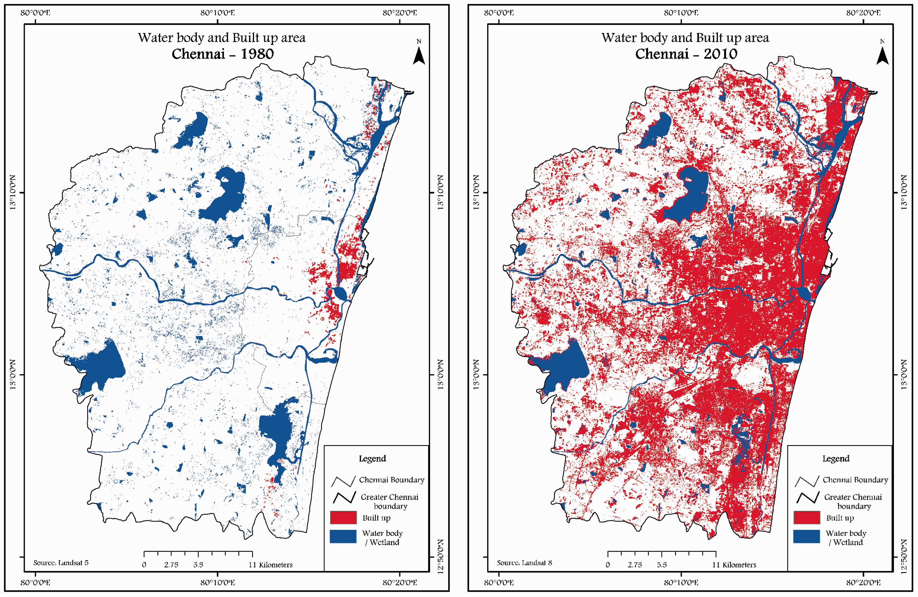
Development through densification
Second Chennai Master Plan, 2008
This territorial transformation was further exacerbated from the early 1990s when the Government of India initiated a series of economic reforms to integrate India into the global economy (Kennedy et al., 2014). An array of policy measures was introduced to encourage private sector investment, disinvest in state owned enterprises, deregulate industries, liberalize trade and foreign investment and change its fiscal policy. This neoliberal agenda ‘represented… broad acceptance of the idea that entrepreneurs and markets were to be given priority over government in the conduct of economic activity’ (Kuppuswamy, 2009: 40). A range of measures were introduced into spatial planning to facilitate these processes. In 1995, the MMDA published a draft Second Madras Master Plan. Its preamble stated that it was ‘in tune with the liberal economic and industrial policies being followed by the Government of India and Government of Tamil Nadu’ (MMDA, 1995: 2). Once published for public comment, the plan was challenged by the Citizen consumer and civic Action Group and stayed by the High Court of Madras. In 2005, the plan was returned to the MMDA for redrafting and it was eventually approved as the SCMP in 2008. Over the 13-year period between the SCMP’s first draft and eventual approval, the FMMP continued to sanction development in the city. Development control rules were amended to make them more amenable to state driven neoliberal imperatives and illegal construction was frequently regularized (Subramani, 2016). For instance, in 1998, after the 1997 Tamil Nadu IT Policy was passed, development control rules were adjusted to encourage IT related development along the Old Mahabalipuram Road (OMR) south of the city (Kennedy et al., 2014; Kuppuswamy, 2009). These amendments encouraged the building of multi-story IT buildings with a premium FSI of 50% more than other multi-story buildings in the metropolitan area, and to a height twice the width of the abutting road (for other multi-story buildings, it was 1.5× the width). These were applicable only on plots a minimum of 2000 square metres abutting roads a minimum 18 metres wide. These measures incentivized IT real estate investment along a widened OMR and rapidly transformed the southern periphery of the city where agricultural land was bought up for housing developments (Joshi and Kale, 2013; Kennedy et al., 2014).
The SCMP had been redrafted in 2006 when memories of the 2004 Indian Ocean tsunami and the 2005 Chennai floods, characterized as the ‘worst in living memory’, were fresh (CMDA, 2008: 95). This translated into considerable attention being paid in the plan to questions of the city’s drainage. Chapter IX, ‘Macro Drainage System in CMA’, drafted by the Public Works Department (PWD), acknowledged that the catastrophic floods of 1943, 1978, 1985, 2002 and 2005 and flooding of a less catastrophic nature occurred because of a failure of the city’s drains (Janardhanan, 2015a). The plan recommended a number of measures to address this, based, unexpectedly, not on improving the city’s drains, but on converting constraints in the disposal of flood waters into opportunities to augment urban water supply through the creation of additional storage. These included developing a network of open spaces to be used as flood moderators during critical months of the year, protecting lakes and water bodies from encroachment, removing existing encroachments to bring water bodies to their original state, prohibiting or restricting development on the Pallikaranai Marsh and in the Red Hills catchment area, and safeguarding waterways and water bodies through development control rules. It was also recommended that tanks be desilted to augment their storage capacity and to capture monsoon runoff and that the concept of ‘zero run-off drainage’ with retention ponds, sediment traps and balancing lakes be adopted (CMDA, 2008: 74).
When reading these monsoon-attuned recommendations against other objectives of the plan, fault lines appear. In Chapter II, ‘Demography’, drafted by the CMDA (2008: 11), the plan proposed to meet Chennai’s anticipated population of 12,582,000 in 2026 by nearly doubling the density of the CMA. To do this, it proposed that residential and industrial land use within the CMA be doubled in area at the expense of agricultural and ‘other’ land (vacant, forest, hills, low-lying and water bodies), which would be halved (CMDA, 2008: 114). Comparing the land use maps in the plan for 2006 and 2026, this is apparent. The blues and greens of water bodies, low-lying land, agricultural, forest and open space zones in 2006 (Figure 7) give way to the yellows, peaches, purples, pinks and reds of residential, industrial, institutional and ‘urbanizable’ zones in 2026 (Figure 8). Of particular note in this re-colouring of metropolitan land use maps is the Ennore Creek in the north from brown (non-urban), white (undefined) and blue (water body) in the 2006 map to the purple of industrial use in 2026, and the Pallikaranai Marsh in the south from blue (low-lying land) in 2006 to red (institutional), purple (industrial) and blue (water body) in 2026. This included measures to render the Pallikaranai Marsh fit for development by surrounding it in a vast network of storm water drains that would effectively starve it of water, ignoring the contribution it made as an aquatic system to the city’s hydrology, ecology and ways of life. ‘The swamp will automatically vanish and only the man-made drains and industrial complexes will be there’ (Thirunavukkarasu, 2002). The land use changes required to meet projected growth in Chapter II of the plan were clearly at odds with the project of recalibrating urban territory with the monsoon evident in Chapter IX. Instead of water retention and protection of lakes and water bodies from encroachment, the plan proposed that urban territory be dehydrated and rainwater be funnelled into drains in order to manufacture additional land for speculation. A hydrological cosmology of drainage and dryness won out against one of wetness and soak (Mathur and Da Cunha, 2006).
CMA – Existing Land Use 2006, Master Plan for CMA – 2026. Source: Chennai Metropolitan Development Authority (2008). CMA – Proposed Land Use 2026, Master Plan for CMA – 2026. Source: Chennai Metropolitan Development Authority (2008).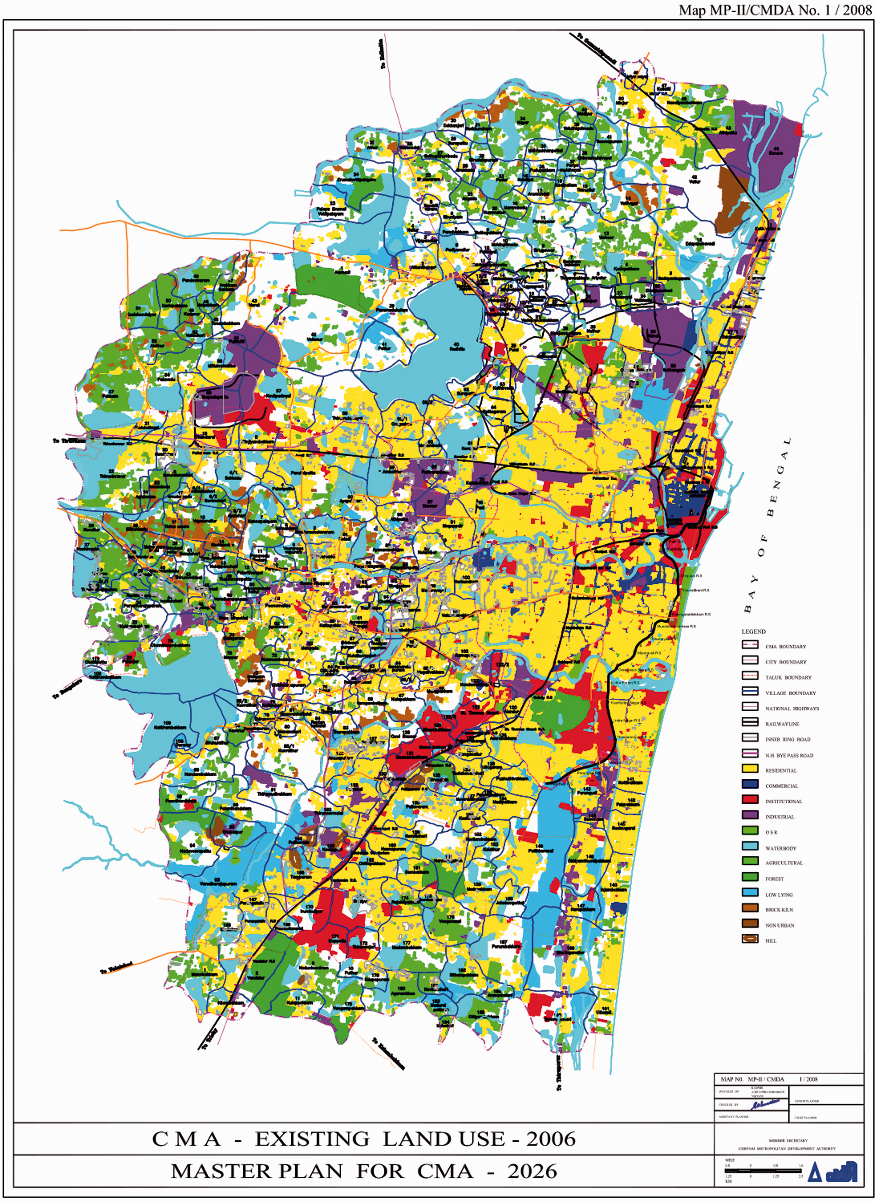

The role of the SCMP was one of ‘broad based’ planning; it was not meant to serve as a ‘daily blueprint’ for development (CMDA, 2008: ii). Local bodies were required to prepare detailed development plans (DDPs) to translate the master plan into workable development controls at a local level, on the basis of which planning permits and permissions would be granted. By 2018, only 56 of the 199 local bodies in the CMA had approved DDPs, meaning that most of the city was without detailed land use maps against which to assess development proposals and, by default, the broad brush strokes of the master plan were used. This was of particular significance for procedures relating to water bodies. Like the MMP, the SCMP shows only the larger water bodies within the CMA. Data about smaller water bodies were not in the public domain and only available on revenue maps from local tahsildes, which were not easy to obtain. It was unclear which government department had jurisdiction over which water bodies, one opinion being that those capable of supplying water for agricultural land of 100 acres or more fell under the PWD, while those whose irrigated area (aiycut) was less than 100 acres fell under the local authority (Sriram and Shekhar, n.d.), but lack of clarity hindered the public’s ability to hold the government to account for planning decisions regarding water bodies. This led to a situation where unauthorized construction and corruption was rampant, not despite master planning, but because of it and the overlapping jurisdictions of the planning system it authorized (Govindarajan, 2016). Inevitably, the requirements of private profitability and the specific interests of particularly powerful players or dominant pressure groups … took precedence over what is due to nature, to future generations or to the less privileged or powerful within society, oftentimes … in the name of development. (Frontline, 2018)
Cosmopolitics
It was into this master planning regime that the northeast monsoon delivered its deluge in December 2015. The floods ‘shook the city to its core’ (Chakchhuak, 2017), interrupting ontological and epistemic certainties and exposing that the monsoon held the city and its plans in little regard. The floods awakened a new sense of precariousness in Chennai’s citizens. This triggered new public associations without vested interests in the formal institutions of representative government or the machinery of planning or policy making, but in ensuring that the forcefulness of the monsoon be responded to in other ways. Most of these initiatives focused on the city’s water bodies, whose agency in both mitigating floods in excess years and retaining water in lean years was widely acknowledged (Jayaraman, 2015; Srivatathsan and Lakshmi, 2011). A study by the Department of Geology at Anna University revealed that the area of water bodies in the city had shrunk from nearly 12.6 square kilometres in 1893 to about 3.2 square kilometres in 2017 (Lakshmi, 2018). The restoration of those that remained became a matter of widespread concern (Latour, 2004) and new publics and restorative instruments and technologies were assembled around them. The messy practices of trash collection, water monitoring, bund reinforcement, water deepening, clearing inlets and outlets, etc. became the focus of new alliances between environmental NGOs, government departments and agencies, cultural and religious organizations, industry, community groups and volunteers. Since 2018 these initiatives have been coordinated by the Greater Chennai Corporation (Nataranjan, 2018).
A detailed evaluation of these initiatives is beyond the scope of this paper and of the research undertaken in its preparation. However, a number of observations can be made from field work with two groups involved in water body restoration in south Chennai in 2017. For many people, water body restoration opened up views into a multiplicity of human and nonhuman urban life worlds hitherto unimagined. Ecological imaginaries were nurtured. Water bodies became what Latour (2004b: 75) calls ‘actants’ or Deleuze and Guattari call ‘quasi-causal operators’ (DeLanda, 2002: 123), catalysing new types of encounter between humans across caste, class and expertise and between humans and nonhumans (water, depth, inlets, outlets, geology, pollutants, trash, fish, birds, plants and insects, to name a few). These encounters triggered new understandings of the materiality of water bodies and the diversity of life that gathered around and in them and built awareness of their wider ecologies. Water bodies became sites of new cosmopolitical occasions and associations and gave rise to new relations between humans and nonhumans and humans with each other. However, the politics of these relations were not always cosmopolitically inclusive. Both water body restoration projects I visited while on field work were set up by middle class residents with vested property interests in making space for monsoonal rains by restoring adjacent water bodies. Residents became protectionist and socially divisive, prioritizing their claims to and associations with the water body as justification for policing or evicting poorer citizens with other claims (see also Nayaraman, 2017). This exposed the difficulties of setting up new modes of ontologically inflected ecological politics so that collective thinking did not exclude those likely to be disqualified because they were seen as having nothing to propose or did not have voices that counted. It also meant that water bodies inevitably became sites around which wider politics of class, caste, land use, ecological destruction and economic marginalization came into play.
Conclusion
A master plan is not just a piece of paper (Jayaraman in Ramanathan, 2015).
I will conclude this paper by returning to questions of planning. The plans I have discussed were not, as in the statement by Jayaraman quoted above, just pieces of paper. They had agency. They were instruments of state policy drawn up by planners and development experts. They conjured up (Arabindoo, 2009), erased (Govindarajan, 2016), re-classified, re-coloured and authorized development in line with state priorities. Since the 1970s they were put to the service of economic interests and hid this complicity behind the ‘ideological curtain of technocratic and apolitical planning’ (Beauregard, 2015: 3). Like all modernist plans, they had ambivalent relationships with the material city, given that they worked with technical data and abstract city making principles, not the messiness of the city itself (Beauregard, 2015). Their translation into material form was indirect and murky, given the powerful interests invested in real estate, the overlapping jurisdictions between metropolitan and local procedures and due to rampant corruption, inefficiency and mismanagement in various government departments (MG Devasahayam in Ravishankar, 2015). Furthermore, a practice of post facto regularization of unapproved property development and encroachment on water bodies was sanctioned (Subramani, 2016) and the judiciary became increasingly embroiled in urban affairs (Dupont, 2005; see also Bhan, 2016). After the 1978 creation of the Madras Metropolitan Water and Supply and Sewerage Board (Sivaramakrishnan and Green, 1986), most infrastructural investment in the city was undertaken by sector-based agencies answerable to their own politically appointed boards (CMDA, 2008: iv). Infrastructural investment was channelled through World Bank commissions or missions defined by the National Planning Commission (such as the JNNURM, Smart Cities), for which cities had to bid for capital funding. These missions prioritized certain sectors, were implemented by sector-based agencies often in a partial and ad hoc manner and usually ignored metropolitan planning (TNN, 2014). Thus, the material city became only loosely aligned with its plan and the effectiveness of the plan as an urban cosmogram was thrown into disarray (Thangavelu, 2015). The failure of the plan to hold the city’s fractured development agendas together or to articulate a common cosmos with the material energies of the earth system was brought into view by the floods of 2015.
The question I would like to conclude this paper with is whether planning might be re-envisaged as a cosmopolitical project in Chennai, and if so how. Following methodologies proposed by Callon (1998), Latour (2005) and Stengers (2005), this would require that the 2015 Chennai floods, or another moment of ontological disturbance, be recognized as a knowledge controversy for planning and trigger new kinds of associative politics to put ‘expert knowledge claims, and the technologies through which these become hardwired into the working practices of commerce and government the subject of intense political interrogation’ (Whatmore, 2013: 39). By slowing down the reasoning of established experts through public scrutiny, the possibility of reasoning differently might be opened up. In the case of planning, this would mean opening up its knowledge practices – technical surveys, the application of abstract city making principles, zoning, land use planning, approval procedures – to public scrutiny. Putting planning experts alongside other experts such as hydrologists and meteorologists normally considered as having nothing to offer city planning and, more importantly, alongside citizens with lived experience of monsoonal events might open up possibilities for planning to frame more ‘hospitable conviviality between city life and intractable and vital forces’ (Tironi and Cavillo, 2016: 210).
There are two international examples of this: Whatmore and Landstrom’s research intervention into the science and politics of flooding in Pickering in north England (Whatmore, 2013; Whatmore and Landstrom, 2011), and a master plan drawn up in Chile after a tsunami ravaged the central coastal region in 2010 (Farias, 2016; Tironi and Cavillo, 2016). These processes both began with moments of ontological disturbance (floods and a tsunami), when inhuman nature interrupted human politics. These events threw into question the knowledge claims, technical arrangements and institutional procedures of flood risk management in one instance and master planning in the other. New kinds of associative politics that put experts alongside people affected by the events opened up possibilities of doing things differently. The results were a new model for flood management in the UK (Whatmore, 2013) and a new tsunami master plan for the central coastal region of Chile (Pontificia Universidad Catolica de Chile, 2010; Tironi and Cavillo, 2016). Both set out collectively developed rules of encounter with inhuman forces, constituting new agencements of ‘territorial cosmopolitics’ (Tironi and Cavillo, 2016: 220).
It is my view that the initiatives around water bodies in Chennai might be elaborated into a collective challenge to the knowledge practices and mechanisms of the planning system if connected with an ecological imaginary that acknowledges the ‘wider field of forces, intensities and durations that gave rise to them’ (Ansell Pearson, 1999: 154 in Whatmore, 2013: 36). This would require thinking planning at a watershed scale (Arabindoo, 2016) and incorporating the sciences of hydrology and meteorology and the experiences of those affected by monsoonal events into planning processes (Murali, 2017, personal communication). Along these lines, ecologist Jayshree Vencatesan appealed after the floods for a ‘cautionary plan’ that did not disturb the ecology of the region and took past rainfall patterns onto account (Ravishankar, 2015). Hydrologist S Jankarajan argued for planning to be aligned with disaster management. 3 He proposed that a weather unit manned by climatologists and meteorologists be set up to understand Chennai’s natural drainage system and rainfall patterns, to map ecological hotspots, survey water bodies and waterways and to plan flood mitigation measures (Special Correspondent, 2016). This grasped conceptually that human life is only partially commensurate with the fluctuating forcefulness of the monsoon and radically re-problematized planning from within meteorological, hydrological and geological processes. The task of planning would become how to set limits to urban entanglements with the monsoon by incorporating multiple voices and knowledge practices to compose the rules that shape those encounters differently (Farias, 2016). This would not be so much about managing relationships between floods (or droughts) and humans (see Greater Chennai Corporation, 2017), but rather about preparing the ground for rain (Da Cunha, 2018), in order to shape more equitable, monsoon-attuned spaces of habitation for human and nonhuman life and to understand and nurture local and regional water ecologies in the light of climate change trends.
Highlights
This paper investigates
Chennai, the monsoon and the political ontologies of the floods of December 2015 Urban plans as cosmograms for establishing, maintaining and extending socio-spatial orders Cosmopolitical experiments in Chennai to compose monsoonal urban worlds differently
Footnotes
Acknowledgements
With thanks to those who shared their knowledge and experience in Chennai in 2017 and to Dr. Beth Cullen, Postdoctoral Research Fellow for Monsoon Assemblages, for discussions while writing the paper. I also thank the reviewers of the paper for their critical remarks, which aided in its improvement.
Declaration of conflicting interests
The author(s) declared no potential conflicts of interest with respect to the research, authorship, and/or publication of this article.
Funding
The author(s) disclosed receipt of the following financial support for the research, authorship, and/or publication of this article: Research for this paper was conducted as part of Monsoon Assemblages, a research project supported by the European Research Council under the European Union’s Horizon 2020 research and innovation programme (Grant Agreement No. 679873).