
Abstract
We review the role of science in shaping river flood risk management policy in England, highlighting the relatively recent influence of fluvial geomorphology, river ecology, climate change and ecosystem services in evidence-based decision-making. These disciplines, together with an historical perspective, catchment-scale delivery, integrated land and water management planning, and adaptive management are crucial in managing future flood risk. A central tenet of previous land drainage policy was a professional (and public) mindset about flood ‘prevention’ solutions for river flooding. As a direct consequence, more than 8,500 km of rivers were ‘improved’ by mechanical dredging during the 1930s to 1980s; habitats were destroyed, but flooding continued. A more enlightened, long-term approach has since evolved in response to environmental imperatives and lessons learnt from several major floods during the last two ‘flood-rich’ decades. River science, local knowledge and land management incentives allow more natural processes to be restored in river catchments. The natural capital and ecosystem service benefits of river systems are now better understood and quantified, whereas the importance of sediment transport is fully recognised, with sources and sinks treated more holistically than in the past. Evaluating the outcomes of innovative runoff and river management techniques from both physical and socioeconomic perspectives will determine the success of a catchment-based approach. We highlight some of the uncertainties, nuances and assumptions associated with recent initiatives such as Natural Flood Management, Citizen Science and Flood Action Groups. Further integration between policy, strategic planning and local delivery is needed to anticipate and respond to climate and catchment land use changes. River science will play a crucial part in identifying the most effective way of improving flood management and in a way that helps to deliver the recovery of nature. It will inform adaptive management to cope with climate change.
Keywords
I Introduction: setting the context
The aftermath of damaging river floods often exposes tensions between distressed flood victims and river managers, bringing into sharp focus the relative priorities for protecting human life, property, critical infrastructure and river ecosystems. Repeatedly, press headlines have featured cases where flood victims have questioned whether flood management policy is more concerned about wildlife than people and livelihoods (e.g. for the River Eden; Carlisle Flood Action Group, 2016). The intensity of local opinion often means that river managers (and their political paymasters) are unable or reluctant to implement solutions backed by river and climate scientists. The outcome is often a combination of short-term local emergency help and longer term ‘hard’ engineering fixes to increase floodwater conveyance. This is regardless of the consequences for both river processes and ecosystems and the likelihood of repeat flooding caused by more extreme rainfall events resulting from climate change.
Restoring and harnessing the benefits of natural river processes are vital for sustainable solutions to river flooding, but the long-term time frame is at odds with the immediate needs of flood-affected communities. In many catchments, smarter versions of existing engineering techniques will continue to do the ‘heavy lifting’, especially in urban centres, while natural processes are managed upstream and at a landscape scale. Ironically, river flooding may be a consequence of poor land use planning decisions made by the very local authorities that have to deal with the aftermath. During the SARS-Cov-2 pandemic, the mantra of ‘science speaking to power’ has provided a sharp policy focus. The principle of a broad science base (from epidemiology to behavioural psychology) informing a risk-based policy response to a major public crisis applies equally to managing flood risk in the context of climate and biodiversity crises.
This review updates that of Johnson et al. (2005), which charted 50 years of ‘land drainage’, ‘flood defence’ and ‘flood risk management’. It includes the current ‘flood-rich period’ (from about 1998) and focuses on river science (for which much evidence was accumulated before 1998) as a driver for policy change. Our scope for river ‘science’ extends beyond the core disciplines of hydrology, geomorphology and freshwater ecology to include an historical perspective, land use management and the hydrological connectivity of river catchments. This reflects a wider, more relevant context first adopted in the UK Government’s 2003 Foresight programme (Office of Science and Technology, 2004).
Our review focuses specifically on riverine elements within the current strategic flood risk policy/strategy framework for England (Defra et al., 2020a; Environment Agency, 2020), highlighting where strong evidence is not incorporated, where myths still prevail and what further input from science is needed. Five headline policy objectives within the strategy (upgrading and expanding flood defences; managing the flow of water more effectively; harnessing the power of nature, reducing risk and creating multiple benefits; and more resilient places through a catchment-based approach) are particularly relevant. We explore whether current scientific knowledge and practical initiatives are sufficient to deliver these objectives and what additional effort is required to maximise the chances of success.
1.1 The ‘fabric’ of flood risk policy
This paper is a distilled review of 130 policy and policy-related documents and more than 100 relevant academic publications. We frame this review using a ‘fabric’ analogy as applied to policy: describing the combination of rigid norms of governance and government (the ‘warp’) and the flexibly interwoven ‘weft’ of proactive and reactive ideas and evidence. For example, the overall strength (and practical benefits) of this fabric would be enhanced by the integration of policy areas such as insurance, land use planning, mental health and flood warning.
The significant ‘warp’ and ‘weft’ strands of recent flood policy development are given in the Appendix. It reveals a loosely strung fabric, with more concerted effort for better integration (albeit incomplete) from around 2018 in response to policy concerns about climate change. Incremental, reactive flood policy appears to have been driven by damaging floods, rather than a strategy informed by foresight, supporting the views of Lane et al. (2013), who highlighted the ‘creative destruction’ role of major floods in the policy arena. Our review reveals the slow, largely academic, evolution of the evidence-based ‘weft’ prior to episodic adoption by policy-makers in the ‘warp’. Research and development in fluvial geomorphology, begun in the 1990s and periodically recompiled, became the basis of policy action in the late 2010s, whereas scenarios for climate change are a more bespoke form of research and development and are policy-specific.
1.2 Development of the policy fabric
The ineffectiveness of the post-1945 approach to floods (comprising largely ‘capital’ works and ongoing ‘maintenance’ of assets) was highlighted by Bye and Horner (1998). They concluded that because protection assets were inadequate, flood warning needed to play a bigger part. The National Audit Office report into the Millennium Floods in 2000 agreed with this conclusion and quantified the investment needed (National Audit Office, 2001). In addition, the report Foresight: Flood and Coastal Defence (Office of Science and Technology, 2004) concluded that ‘existing policies on flooding are not an option’. Greater enlightenment was advocated by the Institution of Civil Engineers adopting the Dutch concept of ‘learning to live with rivers’ – a re-introduction of floodplains as the ‘winter channel’ for rivers (Institution of Civil Engineers, 2001). The EU Floods Directive (Council of the European Communities, 2007) moved the central tenet from guaranteed flood protection to flood risk management and outlined the roles of competent authorities and the need for hazard mapping and taking climate change into account. ‘Learning to live with rivers’ became ‘making space for water’ (Defra et al., 2004). The influential Pitt report into widespread summer flooding of the English lowlands in 2007 provided further compelling reasons for longer term solutions involving land management, surface water management and the spatial management of flood risk via mapping (HM Government, 2008).
Between 2011 and 2016, a broad coalition of scientific, technical and social disciplines introduced an ecosystem services approach to cost–benefit management budget analysis. Climate change adaptation became an imperative in flood risk analysis and quantified additional protection was advocated (see review by Reynard et al., 2017). Another National Audit Office report called for better communication of flood risk to affected communities, highlighting the importance of smaller rivers and surface water runoff (National Audit Office, 2011). Some of these themes were developed further, notably Working with Natural Processes (WWNP). This advocated a more systematic Catchment Based Approach (CaBA), a theme enshrined in the Government’s 25-year Environment Plan for England (HM Government, 2018). In 2020, the agriculture (HM Government, 2020) and environment (Defra, 2020b) Bills and a Planning White Paper (Ministry of Housing, Communities & Local Government, 2020) appeared, both highly relevant, but not explicitly linked with the strategy for floods. More relevant, the Environment Bill included ‘righting the wrongs’ of damage caused to 4000 km of river channel by previous land drainage works. This policy framework by the Government consists of complementary elements of catchment management and evidence-based solutions, incorporating ‘source to sea’, surface water floods and sustainable urban drainage systems (SuDS), reservoirs and sewers, Natural Flood Management (NFM), floodplain connectivity, soil protection, tree-planting and peatland restoration.
Figure 1 shows a much-abridged overview of the drivers for policy development. For simplicity, this does not include essential components such as the water industry or education.
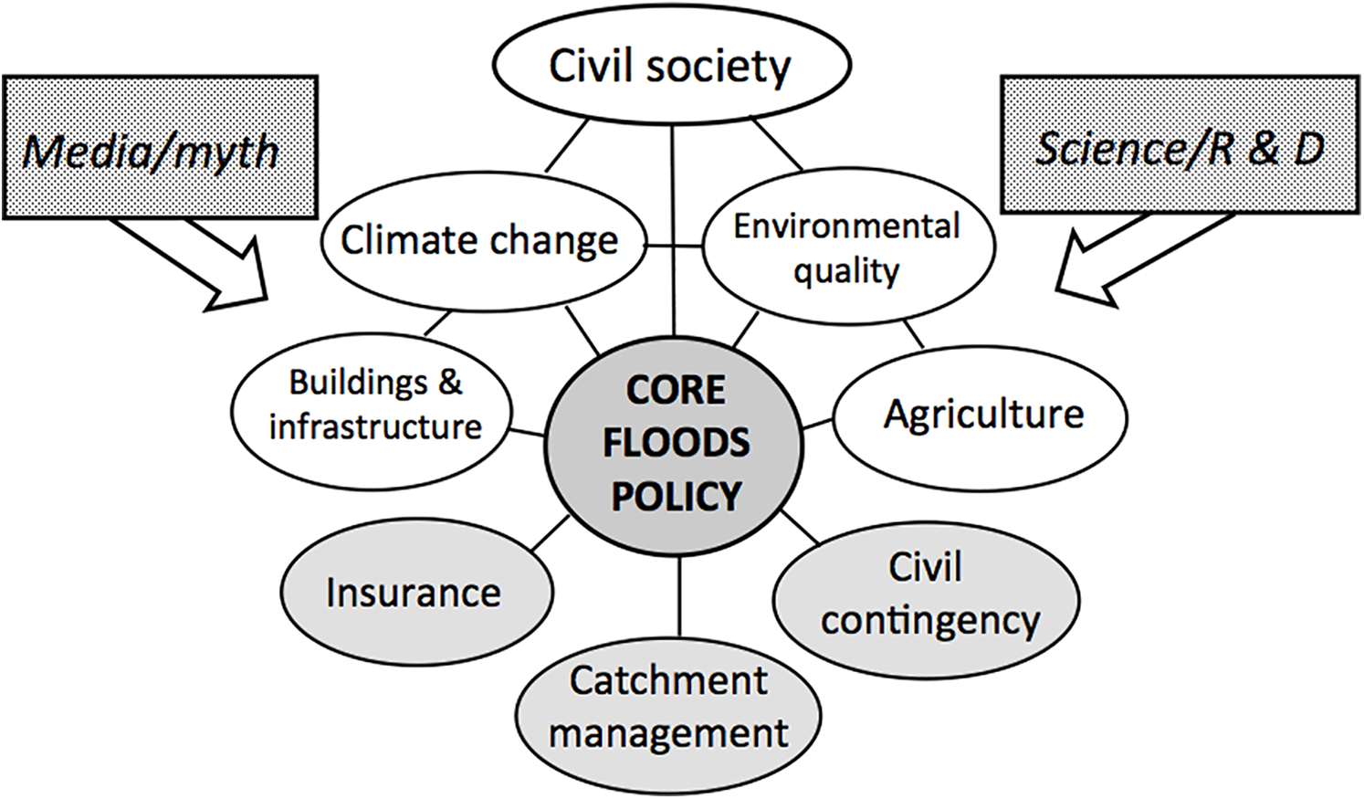
Flood risk influences, management policy development, and agency (note caveats in the text).
II Learning from the past
2.1 Previous floods matter
The EU Floods Directive made it official guidance to develop flood risk guidance using historical flood archives. Because hydrology is a relatively young science, recent flood-related data need contextual information from what McEwen et al. (2016) have described as ‘sustainable flood memories’. This is particularly important when considering a fluctuating and dynamic phase in the data series, such as the current flood-rich period (Blöschi et al., 2020). Media headlines about ‘unprecedented’ floods are unhelpful, while the expression ‘unexpected’ fails to reflect the correct use of statistical probability for extreme events (Serinaldi and Kilsby, 2018). The media fails to mention the serious limitations caused by insufficient river flow data or the statistical basis for terms such as a ‘1 in 200 years flood’, exemplified by the reporting of Storm Desmond in 2015 (Environment Agency 2016; Marsh et al., 2016).
However, flood-affected communities and insurance companies require numerical information about the likelihood of flood recurrence to mitigate future problems and fix premiums, respectively (Penning-Rowsell, 2015). The term ‘1 in 200 years’ misleads the uninformed: it does not refer to the interval between events of similar magnitude, but is an artefact of much-debated extreme value statistical distributions. To address this, Defra et al. (2020a) are assessing the best way of expressing flood frequency using fluctuating (volatile) flood peak datasets. The benefit of including carefully reconstructed epigraphic flood records has already been demonstrated for both large and small catchments (Macdonald and Black, 2010; Macdonald et al., 2014). For clarity and simplicity, we hereafter refer to ‘large, rare’ floods. The recent increase in these events caused by ‘atmospheric rivers’ (e.g. Storm Desmond) is clearly linked to progressive climate change (De Luca et al., 2017; Matthews et al., 2018), suggesting that recent gauged flow data may constitute a non-stationary series.
Detailed forensic field surveys by geomorphologists following large, rare floods provide further proof that past floods matter, especially in remote headwaters. They reveal the extended timescale of catchment sediment systems at their most active, with evidence derived from deposits with dateable chrono-sequences. The impact of Storm Desmond in Cumbria were especially profound, but history reveals they were by no means unique (Watkins and Whyte, 2008). Historical field evidence in the region (Joyce et al., 2018) has been crucial in understanding how sediment from mountain sources is transported downstream into river reaches identified by farmers and local flood action groups for river channel maintenance. A similar approach was taken to identify catchment-scale flood sediment routing upstream from Carlisle (Heritage and Entwhistle, 2020). By contrast, the Millennium Floods caused few instances of river channel change in the lowlands (Sear et al., 2002).
A summary of the research reviewed reveals several benefits of using historical analyses of large, rare floods: (1) the ability to reconstruct peak discharges and flooded areas provides the basis for establishing geomorphological effectiveness (including recovery as in Anderson and Calver, 1977) and causative synoptic weather conditions; (2) reduction in the uncertainty of probabilistic estimates of flood frequency (Potter, 1978; Macdonald and Black, 2010) and inter alia identifying spatial and temporal clustering of large, rare events; (3) the ability to publish data digests soon after the event (Met Office/CEH, 2014; Marsh et al., 2016) to rapidly assess impacts and policy failures; and (4) effective archiving of major events, including personal testimonies, photographs and maps, exemplified by commemorative volumes such as Delderfield (1953) and Platt (2019), which form part of collective memory evidence (Song et al., 2020) and the co-production of flood knowledge (McEwen et al., 2016).
2.2 Disruption of natural river processes
Johnson et al. (2005) identified three sequential flood policy phases: land drainage; flood defence; and flood risk management. Land drainage and its corollary river maintenance formed the approach to river flooding during the ‘great acceleration’ in anthropogenic change from about 1950 (Steffen et al., 2007). Drainage and channel maintenance were applied without any apparent scientific evidence base in an unvalidated (and unopposed) across-the-board government policy. Neither was this approach scrutinised for practical or cost-effectiveness nationally (National Rivers Authority, 1994). A post-war public impression was created that ‘improving’ rivers was also vital to national security (Purseglove, 1988). Moreover, widespread lowland flooding in 1947 and the fatal flooding of Lynmouth in 1952 set in train a vigorous policy of de-naturalising river form and process. Collateral damage by tree debris at Lynmouth (Dobbie and Wolf, 1953) led to ‘pioneer tree clearance’, a maintenance policy that lasted until the early 1990s.
‘Drainage’ includes both field drainage and arterial drainage, each producing impacts that can be demonstrated by gauged flow data (Robinson, 1990). Field drainage impacts vary with soil type, but generally produce more rapid runoff response times by increasing catchment connectivity locally (Bracken and Croke, 2007; Lexartza-Artza and Wainright, 2011). Arterial drainage passes flood impacts downstream, crossing administrative and community boundaries. En route, the isolation of floodplains also reduces peak flow attenuation (Heritage and Entwhistle, 2017). Amelioration of this disruption to natural processes features prominently as ‘floodplain rescue’ in NFM within Defra’s WWNP strategy (Defra/Environment Agency, 2017). The Environmental Land Management System (Defra, 2020c) will need to reconfigure agricultural policy and financing to establish runoff management as a ‘public good’, moving from ‘income foregone’ to a natural capital valuation.
III A change in policy direction
3.1 Rediscovering the benefits of ‘natural’ river processes
The conservation backlash against land drainage was fuelled by evidence not only about ecological damage, but also the benefits of applying sustainable river management principles from the relatively new science of fluvial geomorphology. This produced a partial shift away from land drainage and its associated ignorance and myth that had been at the heart of river maintenance (Sear et al., 1995). From the 1980s, the involvement of the conservation movement and professionals shifted practice away from channelisation and maintenance, which treated river sediments as a site problem solved by regular dredging. Geomorphologists were instrumental in this shift by revealing the high degree of river channel modification caused by the land drainage era and promoting the principles of restoring natural river processes. Implementation, albeit staggered, of the EU Habitats Directive (Council of the European Communities, 1992) and, subsequently, the Water Framework Directive (WFD) (Council of the European Communities, 2000), enshrined hydromorphological parameters as a metric for assessing the ecological health of rivers. At about the same time, sediment input from catchment land use was treated as a major form of diffuse pollution, a significant threat to fish spawning grounds and a complication for flood risk management, notably in lowland rivers (Naden et al., 2003). This complemented previous conclusions that large, rare floods produce threshold changes compared with dynamic equilibrium, an important factor informing the effectiveness and approach of post-flood clear-ups (Newson, 1980, 1992).
The land drainage premise that flood conveyance is impeded by in-channel deposits has been countered by studies demonstrating that floods are mainly throughput events and may actually improve flood conveyance (Heritage and Entwhistle, 2020). Indeed, scientifically based (as opposed to opinion based) hydraulic guidance on conveyance for floodwaters (including sediment transport) has been available for some time (Defra/Environment Agency, 2004; Samuels et al., 2002). Natural processes mean that large, rare, geomorphologically effective floods periodically re-shape dynamic river channels and their associated habitats (British Ecological Society, 2013; Death et al., 2015). Wohl (2016) claimed that floods leave rivers in a ‘messy’ state that both improves habitat and helps manage future flood risk; this vital point remains unproven. However, in some local circumstances (e.g. the configuration of the river and proximity of critical infrastructure), remedial action is extremely limited and flood amelioration priorities will prevail. This constraint is fully recognised by the ‘heavily modified water body’ category in the WFD.
The most influential research-based outputs promoting natural river processes for flood risk management include: river sediment transport/deposition processes and habitat associations (Environment Agency, 2005); a Fluvial Design Guide for the Environment Agency (Defra/Environment Agency, 2009) and Guidebook of Applied Fluvial Geomorphology (Sear et al., 2010); a Channel Management Handbook and guidance on modelling and mapping catchment processes for flood risk planning (Defra et al., 2015); a clarification, especially following floods in 2014, of the role and risks of dredging, improvements in its definition and application (Vickers and Bide, 2014); and trials of heavily regulated de-silting on pilot water courses (Chartered Institution of Water and Environmental Management, 2014; Environment Agency, 2013; House of Commons Committee of Public Accounts, 2015).
In addition, several research reports (e.g. Environment Agency, 2011; Flood Risk Management Research Consortium, 2006) emphasised the catchment context in addressing site-specific problems.
IV State and value of river ecosystems
4.1 Physical state of rivers
Natural river ecosystems are adapted to large, rare floods, partly by overflowing, but channels are particularly vulnerable to damage by emergency engineering responses (Harvey and Wallerstein, 2009). Nevertheless, land drainage policy during the time period 1930–1980 meant that >8000 km of lowland arterial rivers in England and Wales were de-naturalised (effectively canalised) through mechanised excavation and tree clearance. This was carried out for reasons of ‘river improvement’ and even ‘river training’ (Brookes et al., 1981). The conservation backlash resulted in a 1981 House of Lords Select Committee recommending that land drainage authorities carry out pre-works river surveys to identify special wildlife features and to conserve them. In 1984, The Rivers and Wildlife Handbook was published, providing practical guidance on how to do this in practice (Lewis & Williams, 1984). In 1989, the newly formed National Rivers Authority had a duty to both promote and further conservation and developed river corridor surveys, to map river features to help protect and restore damaged habitats (National Rivers Authority, 1992).
Despite the enthusiastic implementation of river corridor surveys and numerous fisheries and conservation projects, a national overview of the state of river habitats was lacking. In 1994–1996 this was rectified by a stratified random baseline survey of >4500 sample sites comprising 500 m lengths of rivers and streams across the UK (Raven et al., 1998). It confirmed the scarcity of near-natural river channels and the extent of modified habitats in both upland and lowland rivers and hence the enormous task of mitigating and reversing damage to natural river processes. It established a computerised inventory of features that could be used to assess the natural capital of rivers and, by linking physical and ecological parameters, the component parts of river ecosystem services.
4.2 Restoring and evaluating natural river processes
The conservation-led river restoration movement began in 1990. It achieved political prominence two years later when UK Prime Minister John Major launched an EU-funded project to restore short stretches of the rivers Cole and Skerne. That triggered the establishment of the River Restoration Centre and several Rivers Trusts (Holmes & Janes, 2012). However, 30 years on, the question remains as to whether very expensive small-scale conservation-led restoration reduces flood risk at a measurable scale, particularly as post-project appraisal is seldom long term (Dixon et al., 2016).
It remains vital to improve the evidence base on whether or not flood risk benefits accrue from small-scale projects (Dadson et al., 2017), which are largely determined by local enthusiasm and opportunities (Adams et al., 2004) and the ability to raise funds (Mant et al., 2016). This is particularly relevant given the UK Government’s long-term commitment to repair 4000 km of rivers damaged by flood engineering and the fact that river corridors feature prominently in Local Nature Recovery Strategies (Wildlife Trusts, 2018). River science will be an important influence in developing the priority-based strategy and costed implementation plan needed to turn policy objectives into reality (Mainstone and Holmes, 2010). In the meantime, the River Restoration Centre has accumulated evidence from hundreds of restoration projects to help provide some answers, albeit at a local scale (www.therrc.co.uk/river-restoration); the Eddleston Water project in Scotland is notable for its performance monitoring (Black et al., 2021).
Monetising the benefits of ecosystem services and quantifying the damage to natural capital provided by rivers and wetlands are much more recent concepts introduced into flood risk management policy (Mott Macdonald, 2020). This approach to evaluation is still in its infancy, but is driven by three main factors: (1) the impoverished state of freshwater ecosystems (UK National Ecosystem Assessment, 2011); (2) the damage caused by flood defence works to natural river assets and to the provision of ecosystem service benefits (e.g. Natural Capital Coalition, 2016; Rouquette, 2013); and (3) the prominence of river restoration as part of the UK Government’s nature recovery message (Wildlife Trusts, 2018; Defra, 2020b).
V Scale-related delivery: catchment-based and smaller scale options
Common law relating to riparian land ownership has limited use for implementing flood risk management policy; litigation is generally only possible between neighbouring riparians. At the catchment scale, regulation via statute law is essential. The obvious scale for statutory consideration of runoff, sediment transport and ecosystems is the river catchment, a principle first recognised in the National Rivers Authority’s Catchment Management Plans (Slater et al., 1994). This scaled approach has developed rapidly during the last 20 years (Catchment Based Approach National Support Group, 2020).
5.1 Importance of land use and management
A CaBA is now enshrined in the UK Government’s 25-year Environment Plan (HM Government, 2018). It promotes a spatial agenda with flood ‘places’ set within patterns of runoff, sediment movement and habitats. These spatial patterns of controlling processes are often set up by those of land use and management, a longstanding topic for hydrological research. However, there are dangers in over-simplifying complex situations and creating unrealistic expectations (Pattison and Lane, 2012). For example, while an impressively large international literature is available, the specific context of the original research (e.g. climate, geology and species) demand extreme care in extrapolation and interpretation (e.g. Defra/Environment Agency, 2005; Flood Risk Management Research Consortium, 2008). The role of source area tree cover in flood events is particularly controversial because local climate, soil and management factors are profound determining factors (Soulsby et al., 2017). Implementation of generic principles will therefore be modified locally by unique catchment attributes and circumstances.
Reported impacts from changes on the land surface at a small experimental scale may raise unrealistic expectations of catchment-scale flood risk management – the same uncertainty applies to NFM. Moreover, regulations encouraging sound land policies are weak, relying on ‘best practice’, laws of ‘nuisance’ and, in recent years, time-limited financial incentives for landowners and managers. These financial incentives are now being recast in the 2020 Agriculture Act under the more appropriate objective of ‘public goods for public services’ (HM Government, 2020).
5.2 Surface water flooding
Changing patterns of rainfall and land use have made surface water flooding (pluvial flooding) more prominent and it was listed for policy change in the Pitt review (HM Governement, 2008). The management of water pathways throughout a catchment requires a comprehensive accumulation of knowledge, awareness, mapping, innovation and practical delivery; pluvial flood risk requires local intervention, but within the broader runoff picture. Two recent initiatives (NFM and SuDS), both playing a part in flood risk management in ‘blue–green cities’, feature in the 2020 strategy/policy and are relevant to this review.
The objectives of WWNP, CaBA and NFM are predicated on a policy mix of engineered flood defences, likely to continue for urban rivers, and more rural/headwater runoff and sediment management, often co-designed with well-informed stakeholders. For example, delivery of NFM is moving to local non-governmental organisations (Wingfield et al., 2019). However, NFM remains largely unvalidated, with success dependent on the results of trial projects (Dadson et al., 2017). One such trial, in the 69 km2 Eddleston Water catchment, used the hydrograph lag-time recorded at ten gauged tributaries (Black et al., 2021). Comparing two years of control conditions with seven years of NFM, the authors noted peak runoff delays of 2.6–7.3 hours in headwaters up to 26 km2.
In similar vein to river restoration, a major problem for strategy and design is that cost-effectiveness comparisons are difficult until conclusive research evidence emerges. Until then, arguments between the proponents of NFM and hard engineering will continue. The Environment Agency (2019: 3) advises ‘that Natural Flood Management can help to reduce flood risk’, but an NFM initiative alone is very unlikely to make a step-change reduction in flood risk for the most vulnerable communities and businesses. Consequently, NFM remains ‘a good but contested idea’ (Bracken et al., 2016); it requires rigorous river science input and post-project monitoring, particularly fundamental research into the flow structures and hydraulics associated with techniques such as floodplain forests (Ressink et al., 2020). For example, the benefits of large wood in river channels for habitat diversity has long been established (e.g. Linstead and Gurnell, 1999), but the effects on flood risk at a catchment scale remain unknown.
Despite the plethora of technical guidance (e.g. Graham et al., 2012) and investigations into benefit–cost and planning aspects (Chartered Institution of Water and Environmental Management, 2017), the latter concluded that ‘policy around SuDS is not working as intended’. Wider benefits, including public access and biodiversity gains, are a central focus in the blue–green cities initiative (Thorne, 2020). Introducing a Royal Society volume on urban flood resilience, Fenner (2020: 7) describes ‘the messy nature of urban flood risk management’, given the huge range of stakeholders in a complex infrastructure landscape. With increased impetus for house-building from the UK Government, SuDS and blue–green policies need greater prominence, support and deployment within planning law to become effective.
Three conclusions can be drawn about these approaches, which have taken a ‘learning by doing’ approach involving community-scale projects. First, their cost-effectiveness has not been adequately assessed. Second, proven nature recovery benefits would increase the incentive for implementing these techniques by broadening the tangible objective beyond conventional flood protection measures to manage runoff. Third, as the Chartered Institution of Water and Environmental Management has highlighted, ‘the main obstacles to high quality and widely implemented SuDS are political and institutional rather than technical or financial’ (Chartered Institution of Water and Environmental Management, 2017: 7).
Consequently, there are serious limitations as well as opportunities for all three approaches (NFM, SuDS and blue–green cities); their success depends on benefits that can only be fully gained through innovative planning and also riparian and agriculture policies beyond the management of rivers themselves.
5.3 Role of local stakeholders, flood action groups and citizen scientists
Devolution of decision-making to local stakeholders has become a feature of UK Government moves to promote resilience in the face of hazards and flooding features prominently in the UK Government’s National Risk Register (HM Government, 2017). Nevertheless, a debate continues about the relative merits of national policy versus local delivery, the former informed by broad scientific principles, the latter by local knowledge and direct experience. Notably, the EU Floods Directive (Council of the European Communities, 2007) recommends the transfer of responsibility for decision-making to the lowest competent administrative level. Perceptively, Lane et al. (2011) described the process of the co-production of flood risk design information within communities as a hybridisation of science and politics.
In the past 20 years, two notable devolved movements have evolved: Flood Action Groups (FAGs) and Citizen Science – active in more than 60 Rivers Trusts since 2001. Additional encouraging signs of effective devolved stakeholder engagement and risk assessment are now emerging, formalised in Local Resilience Forums. The National Flood Forum, established in the aftermath of the Millennium Floods, has played a prominent part in shifting the balance.
Members of FAGs (which now number >200) have been described as ‘civil society actors’; in the wake of flooding, they make the case for using local knowledge to create resilience (Forrest et al., 2017). However, a survey by the Catchment Based Approach/National Flood Forum (2020) concluded that there was ‘little active engagement between CaBA and FAGs’ and some CaBA personnel regarded FAGs as ‘insular groups who did not understand managing catchments’. Inevitably, individual FAGs differ in membership and outlook, but collectively need to decide whether they are pressure groups or citizen scientists. The Citizen Science network has grown rapidly, but its limitations need to be acknowledged and quality control applied to improve the validity of the evidence collected (Newson, 2011).
Several connected themes marking profound change emerge from this scale-related review. First, floods used to be treated as a unique natural hazard, but the Civil Contingencies Act (HM Government, 2004) integrates flood risk assessment, protection and emergency action alongside other national security threats. Second, impacts on flood victims are now part of the economic valuation of risk, just as in health, particularly mental health (Defra et al., 2020b). Moreover, ‘levelling up’ socially is now a major policy theme (cf. the National Audit Office report on Environment Agency defences (National Audit Office, 2020) and the National Infrastructure Strategy (HM Treasury, 2020). Third, ‘localism’ is highly relevant to flood risk management, both from the knowledge gained by experience and by suitably competent citizen scientists. Fourth, within a CaBA context, the local scale is particularly appropriate to innovative lower cost, smaller scale risk management options such as NFM, SuDS and, in urban settings, blue–green cities.
VI Concluding discussion
The new long-term strategy of the Government for flood risk management represents a major change in emphasis from the land drainage era and resonates well in the current flood-rich period. In addition, increasing problems caused by surface water flooding have expanded the scope of managing flood risk. Our review has demonstrated that achieving four key policy objectives in the strategy (upgrading and expanding flood defences; managing the flow of water more effectively; harnessing the power of nature, reducing risk and creating multiple benefits; more resilient places through a catchment-based approach) will be a challenge on several fronts and will depend on the success (or suitable adaptation) of several current initiatives.
We consider that there are four key river science themes to ensure flood risk policy is evidence-based and fit for an uncertain future: better multi-disciplinary approaches to river and catchment science (Vaughan et al., 2009), recognising that the health and durability of society depend on natural processes; improved knowledge transfer, especially from the hydromorphology and ecohydrology science communities, to provide clear technical guidance for practitioners (e.g. Hannah et al., 2004); transforming river restoration and NFM from local opportunism to a rigorous science-led strategy linking natural recovery and flood management; further forensic investigation into catchment and river reach scale effects of large, rare floods, particularly on channel conveyance; and more empirical and/or modelled studies of the runoff properties of exposed engineered/managed surfaces to guide town and country planning.
Further important requirements for identifying sustainable solutions in uncertain risk scenarios include human behaviour dynamics (Aerts et al., 2018), a comprehensive and realistic incorporation of civil society (McEwen et al., 2016) and a rapid assessment of evidence for the risk–costs–benefits of WWNP, notably NFM. In line with Bracken et al. (2016), who highlighted the inadequate auditing of flood risk policies now in place, more coordinated policy formulation and evaluation are required, which means closer working between scientific, institutional and non-governmental organisations.
Broader requirements that are also critical for successful implementation of policy objectives in the 2020 Strategy include: maintaining and building on the ecological foundations of WFD and defining the WFD water bodies (river reaches) that are more appropriate for dealing with flood risk; correcting deficiencies in domestic flood insurance, as revealed by the Doncaster floods of 2019 (Blanc, 2020); progressively stronger guidance or legal requirement for the inclusion of surface water flood risk in planning (currently advisory based on Environment Agency mapping); clarity over the rationale of the devolution of risk management responsibilities, using political and behavioural sciences to judge the best balance between universal technical virtue and local knowledge; sustainable flood risk management demands, in addition to innovation and diversification, a proactive, but adaptive, policy fabric made accessible to the wider public as an integrated whole (Hall et al., 2003).
Another crucial matter is the policy response to climate change, which has been described by Reynard et al. (2017) as the ‘managed adaptive’ approach. The 2020 flood strategy does not specify how the policy response might operate in England; it might be stymied by politicians still critical of decisions redolent of U-turns. However, just as Lane et al. (2011) demonstrated the feasibility of hybridising science and politics, Walker et al. (2013) conclude that an adaptive management approach, embracing uncertainty, can be used to create sustainable plans. The UK Government has just been warned by its Climate Change Committee (Betts et al., 2021) that the climate emergency needs, in addition to the politically prominent mitigation measures, an adaptive approach (currently ‘the Cinderella of climate change’ according to its Chair). However, the Climate Change Committee rank the new policies on river and coastal flood alleviation as showing moderate progress towards a high-quality plan, among the most adaptive.
Johnson et al. (2005) concluded that the evolution of floods policy is inevitably accelerated by national flood events (e.g. 1947, 1953, 1998 and 2000), after which ‘advocacy coalitions’ use the post-flood context to bring forward new evidence. The severity and frequency of events in the current flood-rich period has produced profound changes in approach that characterise the new 2020 Strategy. As Lee (1995: 9) observes, ‘Policies are experiments: learn from them’. The point about river (and other) science is that it is tested for reliability against evidence and experiment. We have shown that previous policy has oscillated, often without supporting scientific evidence, has generally been top-down and fragmented, and at times apparently driven by opinion and hope rather than evidence and experience. The available science base has improved considerably, but that too needs further development to inform policy in the ways that we have identified.
Footnotes
Acknowledgements
The authors are grateful for the expert sounding board for ideas who gathered at Llangammarch Wells, mid-Wales in December 2019, just before the ‘unprecedented’ rainfall of February 2020. The COVID-19 emergency then frustrated our efforts to publish in spring/summer 2020. We acknowledge the wisdom of many river science colleagues, some sadly deceased, who have influenced policy-makers by promoting innovative evidence-based options for flood risk management.
Declaration of conflicting interests
The author(s) declared no potential conflicts of interest with respect to the research, authorship, and/or publication of this article.
Funding
The author(s) received no financial support for the research, authorship, and/or publication of this article.
Appendix
Key to acronyms (references to cited documents within this paper or from www.gov/uk/publications).
| ABI: Association of British Insurers BES: British Ecological Society CIWEM: Chartered Institute of Water and Environmental Management DCLG: Department for Communities and Local Government EA: Environment Agency EU: European Union FCERM: Flood and Coastal Erosion Risk Management HMG: Her Majesty’s Government ICE: Institution of Civil Engineers |
MHCLG: Ministry for Housing, Communities and Local Government NAO: National Audit Office NE: Natural England OST: Office of Science and Technology NFM: Natural Flood Management UKCP: United Kingdom Climate Predictions WWNP: Working With Natural Processes |