
Abstract
Rivers are the lifeblood of many cities, but flood risk is projected to increase due to urbanisation and climate change. Better floodplain management in and near urban areas is required to produce the New Urban Agenda’s ‘just, safe, healthy, accessible, affordable, resilient and sustainable cities’. Many jurisdictions are looking to move or keep people out of human-constructed residential ‘niches’ on hazardous floodplains, but this has proved difficult to achieve. Our historical case studies of colonial societies in ancient Rome, as well as on the Yangtze, Mississippi and Brisbane rivers, show the deep roots of many contemporary flood risk issues, such as failures of risk perception related to recent settlement, the moral hazard of spending on flood defence infrastructure, the creeping nature of floodplain encroachment into ‘niches’ of perceived protection created by structural interventions, the need for a central, ‘whole of river’ approach, and the difficulties of implementing this approach locally. These case studies also suggest solutions, including the adoption of Indigenous perspectives, benefits to incentivise local actors and a historical education strategy to increase appetite for more sustainable flood risk mitigation.
Introduction
Flood risk is increasing at the global level due to unprecedented increase in exposure as new development encroaches into areas of flood hazard (United Nations endorsed New Urban Agenda, no. 64), and as climate change intensifies the magnitude and frequency of flood events (United Nations Office for Disaster Risk Reduction [UNDRR], 2020). Especially in societies with a history of imperialism and colonisation (Whyte, 2018), urban administrations often call upon national governments to provide relief after large floods. The most obvious measure available to minimise these costs is to prevent unwise settlement in high-hazard zones. However, implementing national policies to control risky development gives rise to the implementation dilemma: national officials seek to mitigate hazards and improve preparedness, but have ‘little direct control over the effectiveness of such efforts’ because they must be implemented by ‘subnational governments and individuals owning property in hazardous areas’ (May and Williams, 1986: 5), who have different motivations and constraints than the national government.
For example, in the US, the National Flood Insurance Program (NFIP) provided federally subsidised flood insurance for residents of floodplains, but the subsidy was contingent upon communities adopting land-use policies to prevent further development in floodplains (Kondolf and Lopez, 2018). However, local governments undermined effective implementation of building prohibitions, allowing further encroachments of housing and infrastructure into flood-prone areas and even ‘floodways’ (lands outside of the main channel set aside to convey floodwaters) (Serra-Llobet et al., 2022a). Much has been written about the risk perception and psychological biases that lead people to choose to live in such known hazardous areas (e.g. Meyer and Kunreuther, 2017). New immigrants to floodplains may not appreciate the hazards, a lack of understanding to which imperial/settler-colonial societies should be particularly vulnerable, because they combine widespread resettlement of people (in the ‘home’ country and in colonies) with an attitude of control and exploitation towards the landscape (Whyte, 2018). Moreover, such new settlers often replace native vegetation with introduced species, drain wetlands and re-engineer waterways, all of which can increase flood risk (Parsons and Fisher, 2022). As a result, calls are increasing for more Indigenous input into the management of waterways in these countries (e.g. Martin et al., 2023; Pinner et al., 2019)
Human occupation of lands exposed to flooding can be viewed from several different frameworks. The most successful frameworks view humans as actors within a landscape or ecology. We highlight two: coupled human–landscape systems, which include the well-known ‘levee effect’, and Niche Construction Theory.
In coupled human–landscape systems, human response to natural hazards can modify the characteristics of the risk, by partially reducing the hazard while often increasing the exposure (Werner and McNamara, 2007). Most relevant to flooding is the ‘levee effect’ (Hutton et al., 2019). The term ‘levee’ is used in US parlance to denote an artificial dyke built to ‘protect’ buildings currently in the floodplain. Individuals then perceive floodplains ‘protected’ by dykes to be safe from flooding, which encourages further development. In reality, flood control structures are designed to control floods only up to a flood of specified size (design discharge), leaving urban developments vulnerable to larger floods. In the US, most structural works are built to control the so-called 100-year flood (a flood with 1% chance of occurring in any given year), which leaves a residual risk of being flooded by a larger flood. Over the life of a 30-year home mortgage loan (typical in the US) the residual risk amounts to 26%, a far greater threat than is commonly understood (Ludy and Kondolf, 2012; Serra-Llobet et al., 2022a).
While the literature on the ‘levee effect’ tends to emphasise present-day phenomena, we submit that the economic and social forces (presumably including the psychological drivers) that drive such risky developments can be recognised throughout histories of colonisation and its aftermath.
Niche Construction Theory also recognises that complex socio-environmental feedbacks have their origin in the past. It argues that cultures modify their environments (e.g. by building a dyke) to create more secure evolutionary niches (floodplains partially protected by dykes) and cultures in turn react to this modified environment (with an increasing desire to live on floodplains). Niche construction facilitates colonisation of new environments (Laland and O’Brien, 2010) and so can be important to settler-colonial societies.
Contemporary flood risk is intimately connected with history: it is the result of past decisions and cultural assumptions regarding settlement and land use. Furthermore, the size of benchmark floods (e.g. the 1% mentioned above) is estimated from past flooding. In this paper we investigate historical case studies of floodplain management in urban areas and their hinterlands to chart the dynamics of local versus central interaction in four societies that share imperial/colonial histories. These were intentionally chosen to cover a variety of time scales and periods, geographic locations and extents, technologies and cultures:
Ancient Rome and its empire (c. 1st century BCE to 3rd century CE)
Yangtze River floodplain diversion to Dongting Lake (China, 14th to 20th century CE)
Lower Mississippi River in the USA (19th century CE to present)
City of Brisbane (Australia, 19th century CE to present)
These cases show particular hazards that could recur, but also reveal common elements that can inform the development of sustainable long-term flood management approaches for urban planning in settler-colonial societies more generally.
Case study 1: Ancient Rome and its empire
According to legend (Livy 4.4; Plutarch Romulus 2–3), flooding was vital in the genesis of the city: Tiber River floodwaters deposited Romulus and Remus at the site where they would found Rome (Figure 1). The initial settlements in the late second millennium BCE (Brock et al., 2021) benefitted both from proximity to the river (the transport artery of central Italy) and from elevation on defensible hills out of reach of floods. For centuries, floodplains in and near Rome were reserved for uses other than permanent buildings (Aldrete, 2007; Brock et al., 2021): transport (by river and land), burial, watering and grazing livestock, markets and meeting places (such as the Forum), voting, military parade and drill, sporting and dramatic events.
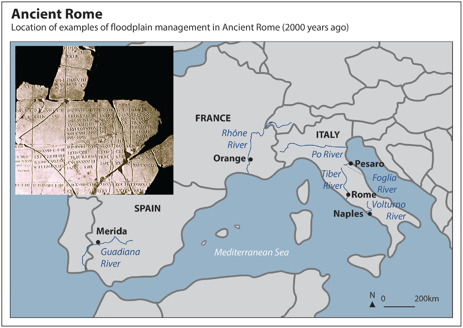
Map of the Western Mediterranean showing the locations mentioned in the text. Inset: A Roman surveying map from Orange showing a river passing through centuriated land plots, now in the Musée d’Orange.
Many structures that had originally been built out of reach of most floods in the Forum Romanum and in the Forum Boarium began to be flooded from the 6th century BCE onwards as a changing river started filling the channel at Rome with sediment, raising the height of the riverbed and decreasing the threshold for the river to overflow onto the floodplain (Brock et al., 2021). Both sediment deposition and urbanisation on flood-prone land increased after the raising and draining of the Forum Romanum in the late 6th century BCE (Aldrete, 2007). By the Augustan period (31 BCE to 14 CE), lack of space in the growing city had led to considerable encroachment onto the last remaining open floodplain near the city, the Campus Martius.
Flooding became such a problem during the heavily urbanised late 1st century BCE/early 1st century CE period that Julius Caesar (dictator in Rome 49−44 BCE) started planning a major niche construction: diverting the Tiber away from Rome (Keenan-Jones, 2013). Fifty years later, the Senate considered another niche construction: a large-scale programme of damming and diverting tributaries upstream. Out of the two proposals, Caesar’s plan would have garnered more support had he lived to execute it. Unlike works far upstream, major engineering works near the city provided employment to the large population of poor and unskilled workers in Rome.
Caesar’s contemporary, the orator Cicero, presents a more traditional view that eschewed innovation and niche construction: ‘no part of natura’s management can be criticised: the best possible outcome has been produced … no one would ever seek to alter natura, but if they did, they would only make the situation worse’ (On the nature of the gods, 2.34.86–7). This view was deployed by upstream communities to convince the Senate to abandon its Tiber geoengineering proposal. To many in Rome’s Senate, niche construction should be limited to continual agricultural improvement of one’s land (Keenan-Jones, 2013). This more restrained niche could, nevertheless, also be threatened by flooding (Varro, On Agriculture 1.14.1). Roman law allowed landowners to build up riverbanks (like small dykes) to meet this threat, as long as no one else was disadvantaged (Campbell, 2012: 103).
Rome’s early desire to leave ‘room for the river’ informed the design of the colonies that Rome founded as its empire grew. Colonies consisted of an urban nucleus, where politics, commerce and residences were concentrated, and a hinterland where immigrant colonists received plots of land (De Nardis, 1994).
A colony’s founder would arrange a topographic survey that included measurement of the riverbed (Campbell, 2012: 79, 104–105). Survey maps were archived in Rome in case of later disputes. It was standard practice to measure an additional area alongside rivers that was classed as subsecivum – meaning excluded from survey or allocation to any landholder – to allow for flooding (Campbell, 2012). These subseciva (plural) often effectively functioned as commons that neighbouring landholders could use, for example, as grazing land, when the river was not in flood. Local landholders recognised the value in this process. Where river survey or flood buffer zones were lacking or insufficient, they were requested (e.g. of the Guadiana river at Augusta Emerita, modern Merida, Spain, Figure 1) or added (e.g. on the Volturnus River in Campania, Figure 1, Hermon, 2016).
Roman landholders clearly did value land adjacent to the river: archaeological remains of Roman villas in the Tiber Valley are preferentially located near the river (Marzano, 2007: 159–160). In addition to subseciva, there were agricultural and economic reasons for favouring proximity to the river (Campbell, 2012: 79; Marzano, 2007: 154–160): fishing, the fertilising effect of flood silt (Columella 3.11.8), washing of fleeces (Columella 2.21.2) and the importance of river transport (Cato On Agriculture 1, Varro, On Agriculture 1.16.6). At the colony of Arausio (modern Orange, France, Figure 1), no subseciva seem to have been allocated: all the surveyed plots were of equal size, even though some contained riverbed (Figure 1 inset). Probably here the benefits of river frontage were considered sufficient compensation for the area lost to cultivation because it was occupied by the river (Campbell, 2012). If there were complaints by landholders, they have not survived.
Sometimes residences were located near the river but above the reach of floodwaters (Marzano, 2007: 397, 712, 769), but in many cases this does not seem to have been possible or even desirable. Many elite Romans liked living right on the water (e.g. Cicero Letters to Quintus his brother 3.1.1–4), a desire that worsened the damage by a flood near Rome in the early 2nd century CE (Pliny the Younger Letter 8.17). The poet Statius (Silvae 1.3) highlights river views (including reflections), sounds and tranquil flow as attractions.
Rome founded many colonies in Italy from the late 4th century BCE onwards, especially during the unstable late 2nd and 1st centuries BCE (De Nardis, 1994). The Roman writers on surveying (Thulin, 1913: 3.6–12; 41.9–26; 78.3–6; 96.21–97.8; 128.1–2) show that the use of subseciva (which also included surplus or odd plots of land) as commons seems to have broken down during the 1st century CE as neighbouring landholders, emboldened by long usage, seized the subseciva for themselves. Many colonies responded by reasserting their authority over subseciva within their jurisdiction, leading to numerous legal disputes. The colonies must have been successful, as they received significant income, probably by renting the subseciva to the occupiers (as was the policy in Thulin, 1913: 44.17–21). In response, the Flavian emperors (69–96 CE) began to either tax or confiscate the Italian subseciva, before reversing this policy and granting Italian subseciva to the large number of landholders then occupying them (Suetonius, Life of Domitian 8.3, Corpus Inscriptionum Latinarum 9.5420). The number and extent of subseciva must have been considerable.
At the colony of Pisaurum (modern Pesaro, Figure 1), this removal of subsecivum increased flood exposure (Thulin, 1913: 44.20–23; 88.4–18; 121.26–122.17). The flat, enclosed topography made the floodplain very marshy and flood-prone, with the result that the surveyors probably classed the entire lower Foglia River floodplain as subsecivum (Thulin, 1913: 122.2–3), c. 600 ha in total (Gallerini and De Donatis, 2009). This was six times larger than the usual size for a subsecivum (75–92 ha, Dilke, 1967: 14). Eventually, the community sold that unallocated land to neighbouring landholders for profit (Campbell, 2012: 104). Every time the river flooded, however, and these landholders suffered damages (presumably to buildings, livestock or crops), they sued the local government for compensation. This suggests the landholders could at least argue that they were owed some flood risk mitigation, and vindicates the initial provision of subsecivum.
The variation in floodplain action by surveyors, land-owners and administrators at Rome and in its colonies vividly illustrates the problems of surveying and settling unfamiliar territory and the tension between flood risk mitigation and the attraction of living on the floodplain.
Case study 2: Yangtze River diversion into Dongting Lake, China
Below the outlet of the Three Gorges, the Yangtze River flows through an extensive plain of modest relief (Figure 2). About 120 km downstream of the Three Gorges Dam (constructed between 1996 and 2006), natural secondary channels convey floodwaters southward onto the floodplain and into Dongting Lake, which would swell many-fold during flood season. These stored floodwaters then slowly drain via another set of channels (Figure 2f) trending north-eastward to rejoin the Yangtze River farther downstream (Perdue, 1982). Even with the dam in operation, the lake still swells during floods, but to a lesser extent. The organic-rich soils of the bed of Dongting Lake have long attracted local farmers, who have built dykes to prevent inundation of parts of the lakebed, constructing a niche that allowed them to farm but reduced the ability of Dongting Lake to accommodate floodwaters.
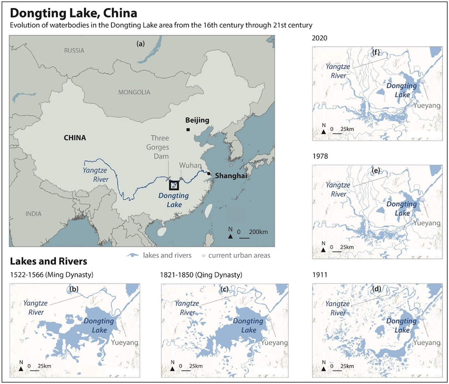
Evolution of waterbodies in the Dongting Lake area from the 16th century through 21st century based on historical documents. (a) Regional location map of Yangtze River and Dongting Lake, China. Lakes and rivers in: (b) 1522–1566, during the Ming Dynasty, (c) 1821–1850 during the Qing Dynasty, (d) in 1911, (e) in 1978 and (f) in 2020.
The history of Dongting Lake and its changing volume is complicated by multiple factors, including reclamation and deforestation. During the Yuan Dynasty (1271–1368 CE), reclamation of floodplain lakes was strictly prohibited, resulting in the expansion of the lake area. Political instability at the end of the Yuan dynasty depopulated the area around Dongting Lake and the neglected niche decayed, allowing the lake area to increase. From the beginning of the Ming dynasty in 1368, however, continued political instability led many refugees to settle in and near Dongting Lake. Through the rest of the Ming (1368–1644 CE) and Qing (1644–1911 CE) dynasties, population pressure on the lake and environs continued to increase. The resulting demand for agricultural land was met in two ways: (1) widespread deforestation, which increased erosion and sediment delivery to the lake, filling it in and facilitating (2) reclamation of lakebed (Figure 2b and c) by building dykes (Guan and Cai, 1986; Zhang, 1981).
These encroachments into the lakebed by private farmers were mostly opposed by officials of the central government through the Ming and Qing dynasties, who understood the important role played by the lake in managing floodwaters. Officials ordered dykes to be removed or breached, so that farmland would revert to wetland and could accommodate floodwaters. Local landowners resisted, ignoring local edicts, coopting local officials, and confusing the issue with lawsuits. Land clearing and draining continued (Perdue, 1982).
In the late Qing, the government changed to a more extractive policy, likely reflecting the same administrative mindset that increasingly pursued colonial policies of resettlement in outer-lying areas (Di Cosmo, 1998). They even encouraged reclamation of highly productive land from the lake to generate more revenue, accelerating the shrinkage of the lake (compare Figure 2c). This shrinkage continued to the late 20th century (Figure 2b–f). As the lake area has decreased, so too has its capacity to absorb floodwaters, with consequences for flood heights and impacts elsewhere. The capacity of the lake continued to decrease in the 20th century, from 31.4 mm3 in 1954 to 18.7 mm3 in 1983, at the same time as urban areas along the Yangtze increased dramatically (Zhang, 1991, as cited by Zong and Chen, 2000). The extensive damages from the 1997 Yangtze River flood, including many cities near to and downstream of Dongting Lake, were attributed in large measure to the loss of flood storage in the Dongting Lake bypass system (Zong and Chen, 2000). The history of Dongting Lake illustrates how protection of urban areas from flooding often involves consideration not just of the urban area, but also of the hinterland.
Case study 3: The lower Mississippi River, United States
The experiences of the pre-Columbian inhabitants of the lower Mississippi River are known from archaeological remains and the accounts of explorers such as Hernando de Soto who, almost 500 years ago, witnessed extensive flooding in the Mississippi. In 1539, de Soto recorded how Indigenous inhabitants coped with this natural hazard, including through moderate niche construction: ‘The Indians built their houses on the high land, and where there is none, they raise mounds by hand and here they take refuge from the great flood’ (cited in Hickcox, 1994). Large areas of productive agricultural land were maintained on the lower, flood-prone ground between the mounds (Rodning and Mehta, 2019). However, colonists did not follow the indigenous example of ‘living with floods’. During the following centuries they engaged in more extreme niche construction: thousands of kilometres of dykes and canals were built along the Mississippi River; upland farmers cut forests and floodplain settlers ploughed prairies and drained wetlands, turning the land to agricultural production (Hickcox, 1994).
These transformations contributed to increasing flood magnitudes, and the Mississippi and its tributaries continued to be plagued by large floods through the 20th century. After the devastating 1927 flood, the US Congress authorised the Mississippi River and Tributary project (MR&T) to control floods and maintain a navigation channel (Lopez-Llompart and Kondolf, 2016). The MR&T went beyond the former, discredited ‘levees only’ approach, and added four floodways and four backwater areas (floodplain areas intended to flood, so that they store water during floods) to safely divert or store excess flows at critical reaches, relieving stress on the dyke system (Serra-Llobet et al., 2018). Like in Rome, new, geo-engineered, niche-construction solutions, especially flood-control dykes, would have been politically popular as they spent federal funds in local electorates. Here we consider the largest land-use conflicts in two of these features, the Birds Point–New Madrid and the West Atchafalaya floodways (Figure 3).
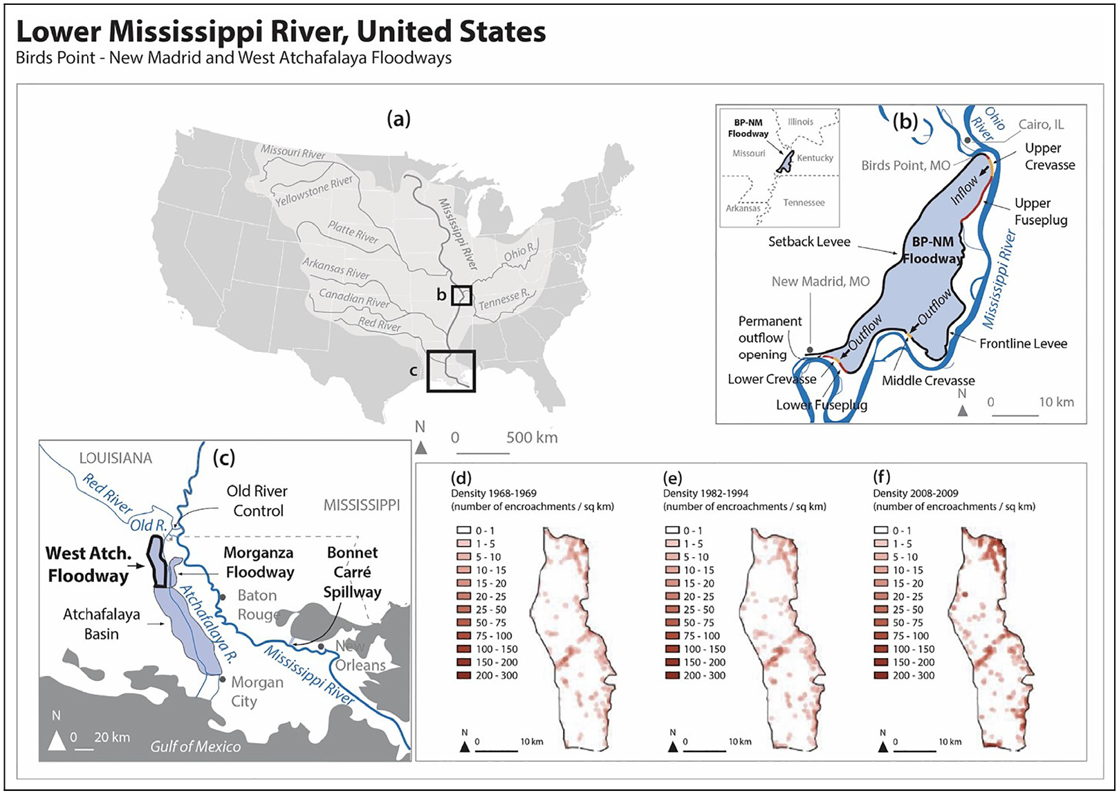
(a) Location of the Birds Point–New Madrid and the West Atchafalaya Floodways in the Mississippi River. (b) Birds Point–New Madrid Floodway in relation to other features of the Mississippi River and Tributaries Project. (c) West Atchafalaya Floodway in relation to other features of the Mississippi River and Tributaries Project. (d–f) Density of encroachments (number of encroachments/km2) in West Atchafalaya Floodway at the three studied time periods: (c) 1968–1969, (d) 1982–1994 and (e) 2008–2009.
The Birds Point–New Madrid Floodway is located on the west bank of the Mississippi just downstream of the confluence with the Ohio River (Figure 3a). It can divert 15,500 m3/s from the Mississippi River during floods, lowering flood height by about 2 m near Cairo, Illinois, once the upstream section of the dyke is breached with explosives. At the downstream end of the floodway, floodwaters return to the main Mississippi River channel. Land use in the floodway is dominantly agricultural.
As described in a letter sent annually to all properties in the floodway, the US government ‘holds a perpetual right to flood the properties and improvement thereon. The Government’s recorded easements provide that the United States shall in no case be liable for damages … that may arise from or be incident to operation of the aforementioned floodways’ (USACE, 2015). The New Madrid Floodway has been used only twice, in 1937 and in 2011 (Lopez-Llompart and Kondolf, 2016). From 1937 to 2011, local interests became accustomed to the floodway being dry and usable for agriculture. As floodwaters were rising during the record flood of 2011, the State of Missouri, seeking to prevent inundation of its lands, brought a lawsuit to prevent activation of the New Madrid Floodway, despite activation being required by the MR&T to protect lands in the town of Cairo, Illinois, and elsewhere. The case went before the US Supreme Court, which affirmed that the floodway should be operated as intended. The ruling was barely in time, allowing the dyke to be exploded just before it could no longer be reached due to rising floodwaters (Serra-Llobet et al., 2018). This lowered the river height at Cairo and elsewhere along the east bank of the river.
Thus, the New Madrid Floodway, a critical component of probably the largest public works project for flood safety in the country, was almost rendered inoperable by the resistance of local interests.
Farther downstream in Louisiana, the West Atchafalaya Floodway is designed to accommodate flood waters from the mainstream Mississippi and from the Red River, discharging into the Atchafalaya River, which carries about 30% of the Mississippi’s flow on average (Figure 3c) to the sea (Serra-Llobet et al., 2022). The floodway is almost entirely swampland.
The functioning of the West Atchafalaya Floodway has also been compromised by local interests, but through a different mechanism: unbridled development within the Floodway. While within the New Madrid Floodway the number of encroachments (e.g. buildings, shelters, tanks) dropped by half from the late 1960s to 2013, over essentially the same period encroachments in the West Atchafalaya floodway tripled to more than 4300 (Lopez-Llompart and Kondolf, 2016, Figure 3d–f). The reduction in encroachments in the New Madrid Floodway can be attributed to the increased mechanisation of agriculture and reduced need for labour, while the increase in structures in the West Atchafalaya apparently reflects local perceptions that use of the floodway for flood mitigation is unlikely, and is incentivised by cheap land prices in the swampy floodway. The existence of thousands of houses within the floodway now cannot be ignored by emergency managers during a major flood on the Mississippi River. The West Atchafalaya Floodway is passively activated by high water from the Mississippi passing through the Old River Control Structure and high water on its tributary the Red River, so activating the floodway does not require such a proactive measure as the setting of explosives (as done on the New Madrid bypass). To the extent that emergency managers control the flows that might go through the West Atchafalaya Floodway, they may be influenced to avoid using the bypass so as not to flood the homes now within it. If managers avoid using the floodway during big floods, they run the risk of displacing higher river levels to urban areas downstream.
In both cases, local interests have undermined the functionality of important national infrastructure: New Madrid by legal challenges to its use, West Atchafalaya by filling it with residential development such that it is now less suitable for deliberate flooding. Both cases highlight the disconnect between national policy and local land-use decisions (Kondolf and Lopez-Llompart, 2018).
Case study 4: Brisbane, Australia
Australia has much greater variability in rainfall and river discharge than other continents, due in part to the El Niño Southern Oscillation (Karskens, 2016). This climatic and flooding regime has (for millennia) been a key part of the mythology and lifestyle of the Turrbal and Jagera/Yuggera peoples: Moodagurra (the Rainbow serpent) or Duelgum (freshwater eel) created the Brisbane River and decided the timing of floods (Shannon Ruska, Nunukul Yuggera man & Joe Kirk, Turrbal and Wakka Wakka elder, cited in Cook et al., 2022: 29–30). For millennia, Indigenous inhabitants had harvested fish and other resources from river and floodplain and seasonally ‘rotated around, allowing nature to provide and crops to regenerate’, (Jagera elder Neville Bonner, cited in Cook et al., 2022: 32–33). Then as now (Pinner et al., 2019), the river was a place for swimming and intergenerational learning and experience. Indigenous people made camps near the river, but generally at a sensible 14 m above sea level (asl) in the wet season (Kerkhove, 2016: 1), well above the highest recorded flood level in the city of Brisbane since British settlement in 1824, 8.41 m asl (Aurecon Australasia Pty Ltd, 2015).
This flood regime was very different from the rivers that settlers from Britain and Ireland were used to (Cook, 2019). While some Australian agricultural settlers adapted quickly (Karskens, 2016), the city of Brisbane did not, and was to suffer badly from major floods resulting from cyclones and severe storms dumping extreme volumes of rain on the Brisbane River catchment in very short time frames (Cook, 2019). Settlement on the floodplain, despite the early warnings of Indigenous people, has been a feature of the city since its foundation. The major floods of 1841 (the worst on record) and 1844, coupled with 1843’s moderate flood, did not prevent the beginning of free settlement in flooded areas in 1842. The settlement expanded significantly, hampered by only moderate floods, until five major floods in the late 1880s and 1890s (Aurecon Australasia Pty Ltd, 2015).
After the terrible 1893 floods, the sites of some badly affected houses were used by local authorities to form parkland, but most government and citizenry placed their hope in engineered, niche-construction solutions (Cook, 2019). Initially the river was dredged and pinch points widened. Then improved technology allowed the first dam, Somerset Dam, to begin operation in 1941. Both Somerset and its larger successor, Wivenhoe (completed 1985), had dual, contradictory purposes: to store water for municipal supply, and to mitigate floods. Australia’s extremes of flood and drought make it difficult to do both tasks. Near the end of rainy (La Niña) periods, the dam should be kept as full as possible to store water for the next drought (El Niño), but a full dam can store only a small amount of flood water.
Like dykes, dams provide decreasing flood protection as the size of the flood increases. Wivenhoe, Somerset and the other dams on the Brisbane River reduce the peak discharge of the estimated 1% flood by only 29% (Aurecon Australasia Pty Ltd, 2015). Moreover, due to their position, the dams can detain floodwaters from only about half of the Brisbane River catchment. These dams were never intended to, and did not, prevent flooding on the scale that occurred in 1974 or 2011, but only mitigated it. The general public perception was that they should control floods and protect homes, however, and bitter recriminations against dam managers followed each flood (Cook, 2019), another clear example of a coupled human–landscape system.
After the 1974 flood, federal government pressure resulted in the first state and local regulations to restrict development in the most-flood prone areas, but these regulations were weaker than elsewhere in Australia (Cook, 2019). Many developers also used their deeper pockets to circumvent these planning regulations by taking local authorities to court. During this article’s preparation in 2022, low-lying residences on the Brisbane River were flooded twice, underscoring that dams cannot completely protect from major floods.
Discussion: Learning from the past to improve the future. Recommendations to improve current urban planning practices
Despite their vast separation in time and space, the case studies show intriguing commonalities that have important implications for current policy, suggesting that mitigation policy that responds to these commonalities is likely to lead to greater flood resilience. Firstly, there are many benefits in most societies to having residences, urban settlements and other activities (e.g. agriculture) located near a river, hence there is a need for effective flood risk mitigation.
Benefits of Indigenous/long-term, sustainable knowledge and perspectives
The case studies show that Indigenous and long-term residents know, and have adapted to, the flood hazard associated with a particular floodplain. Where possible, residences are located to minimise both distance from the river and flood hazard (through elevation) and less vulnerable activities, such as agriculture and grazing, are carried out at lower elevation on the floodplain. Conversely, more recent settlers are often less mindful of flood hazard and more willing to use the floodplain in vulnerable ways (e.g. for residence at low elevation), especially where urban population densities increase pressure to settle on available land. In addition, settler-colonial societies are often more willing (and able) to employ structural measures (e.g. involving dykes, dams and flood diversions) to construct a residential niche in high-hazard, low-elevation floodplain areas, in part due to patronage benefits.
This knowledge and attitude gap shows the importance of Indigenous input into floodplain policy, something still resisted in Australia (Hartwig et al., 2020). Indigenous histories of restrained but successful niche construction need to be better known and applied more widely. Many floodplains in settler-colonial societies are now so engineered that a long-term perspective is necessary even to be aware of other alternatives.
While direct Indigenous input is lacking, Indigenous-style perspectives are increasingly part of a more reflexive flood policy that looks towards, for example, nature-based solutions. These include a ‘new’ planning paradigm, termed the espace de liberté (freedom space), that preserves a corridor within which the river can flood, erode, deposit and migrate (Biron et al., 2014). Some governments are already moving in this direction. Since the mid-19th century, New Zealand has recognised the ‘Queen’s chain’, a buffer zone along watercourses for public use (Sanders, 2012), which also serves to provide some space for natural river processes. In Spain, urban development is restricted in the 0.2% (‘500-year’) flood zone designated under the national regulation of the ‘Public Hydraulic Domain’ and its updates (Royal Decree 638/2016). Cities such as Munich (Germany), Geneva (Switzerland), and Portland (Oregon, US) are giving rivers a corridor to accommodate both flooding and dynamic processes (Kondolf et al., 2021; Ozawa and Yeakley, 2004). However, this is not always possible where urban development has encroached to the banks of engineered channels (a good example of a coupled human–landscape system, Werner and McNamara, 2007), such that expanding the width of the river corridor would require the purchase and/or condemnation of hundreds of costly private residences. In growing cities, preserving accommodation spaces for floodwaters and fluvial processes before they are lost to concrete is key to avoid path dependency that plagues the transition to sustainable urban planning (Ferguson et al., 2013).
As well as through Indigenous perspectives, the lack of long-term knowledge can be addressed also by research into flood hazard. To assess sustainability transitions, it is important to have the best possible baseline against which to estimate and measure the changes in hazard resulting from climate and land change, urbanisation and any land subsidence. All estimation of flood hazard, such as determining the United States 1% or Spanish 0.2% annual probability floods mentioned above, or the extent of buffer zones such as subsecivum, requires a long-term perspective. Recent guidelines (e.g. US Guidelines for Determining Flood Flow Frequency, Bulletin 17C and Chinese SL 44–2006 Regulation for calculating design flood of water resources and hydropower projects (in Chinese: 水利水电工程设计洪水计算规范)) are increasingly recommending the use of historical and geoarchaeological evidence of floods to extend measurement series that are too short for effective estimation of future flood probability (Engeland et al., 2018). In Rome, historical data has been used (Calenda et al., 2005) and geoarchaeological data is becoming available (e.g. Brock et al., 2021). In six Australian catchments, uncertainties in estimated hazard were reduced by 51–66% through the addition of only one to three geoarchaeologically determined flood heights (Allen et al., 2020).
Similarly important is education for residents in the history of flooding in their area. The long record of floods in long-domesticated landscapes is often prominently preserved by high-water marks inscribed on prominent landmarks such as churches (in Rome, Calenda et al., 2005) and bridges (a practice revived in Brisbane after the 2011 floods). Similar artistic interventions to remind current residents of the flood heights that have occurred and can reasonably be expected to occur again are more widely needed, as encouraged in the Watermarks Competition held by University of California Berkeley in 2013. As was the case in classical Rome and Indigenous Brisbane, flooding merits a place in foundation myths of flood-prone cities, perhaps through commemorative events and festivals encouraged by governments.
Central versus local
The case studies also show that construction (and, afterwards, maintenance) of the niche is encouraged by economic windfalls (and then sunk costs) for local actors (and then niche residents), whose priorities are at odds with central government. This niche construction modifies flood risk in complex ways (sometimes including increasing hazard outside the niche) and people tend to underestimate the new hazard within the niche. When the niche fails, there will be attempts (often legal) to transfer costs up the administrative ladder, that is, from niche residents to local government (including urban administrations) to central governments.
In each case, central government policies to prevent development in high flood hazard areas were undermined by local decisions. Nevertheless, the regional nature of flood hazard changes resulting from floodplain niche construction shows the importance of effective central government planning, like that enforced by Yuan China and attempted in the 20th–21st century US. In the Netherlands, such problems were approached by using mixed centralised–decentralised governance in a Room-for-the-River project (Rijke et al., 2012). Educating people about the positive aspects of accommodating space for floods (Serra-Llobet et al., 2022b) can help provide the political support and social licence helpful for democracies (the 21st century US and Australia) and authoritarian regimes (Imperial Rome and Ming China) alike. Informing residents of historical floods and flood mitigation in their area (and elsewhere) can be a novel way to increase engagement and buy-in – key factors in the success of any policy – through pride and interest in heritage. Historical examples have been shown to be particularly effective in garnering support among conservatives who are generally less supportive of environmental action in the US (Baldwin and Lammers, 2016) and likely elsewhere.
To incentivise local interests and governments to implement central policy, central governments may need to develop an incentive structure that can stand up to the short-term profits promised by urban development. The Roman practice of subsecivum provides an example of imbuing value to the floodplain: in modern contexts this land reserved for the river but valued by neighbouring residents (Hawken et al., 2021) could take the form of
allotments for gardening, benefitting from alluvial soil brought by floods, as New Zealand’s Indigenous Māori recognise (Parsons and Fisher, 2022);
linear, flat parks ideal for walking and cycling paths, as in the American River Parkway in Sacramento, California (Zingraff-Hamed et al., 2022);
markets (like the Roman Forum);
dog areas; and
carbon sinks (particularly near river mouths, Macreadie et al., 2019).
Publicly accessible recreation spaces on floodplains can also benefit the local tourism industry (Hawken et al., 2021). These could form part of the open space central to a sponge or floodable city.
The land could be held in a local trust, where neighbouring residents are part owners, to prevent sale and to manage the land as a commons. Clearly, as in the case of Roman Italy and Pisaurum in particular, this will not always be successful, and will require the commitment of local and national governments. Effective consultation of local residents will be important.
Conclusion
Our four case studies show that floodplain development in settler-colonial societies has often underestimated flood hazard and overestimated protection afforded by highly engineered ‘niches’, in contrast to the Indigenous societies that they displaced. This remains at the root of urban flood exposure in these societies today. Future research should compile contemporary examples of alternative urban floodplain use and assess them in terms of resistance to development pressures and local satisfaction and benefits. Combined with increased historical awareness of the floodplain, this will help to resolve tensions between central and local interests, allowing a just transition to long-term sustainability.
Future work could be carried out in co-operation with Indigenous people, for example in the Mississippi and Brisbane areas, to learn more about their long history of adaptation on their floodplains and, crucially, to involve them significantly in the management of those floodplains (echoed by Martin et al., 2023; Pinner et al., 2019).
Footnotes
Declaration of conflicting interests
The author(s) declared no potential conflicts of interest with respect to the research, authorship, and/or publication of this article.
Funding
The author(s) disclosed receipt of the following financial support for the research, authorship, and/or publication of this article: We acknowledge support for manuscript preparation from the Collegium—Institut d’Etudes Avancées, Université de Lyon, National Natural Science Foundation of China (No. 42271007) and the EURIAS Fellowship Program and the European Commission (Marie-Sklodowska-Curie Actions-COFUND Programme FP7), the Institut d’Études Avancées d’Aix-Marseille Université and the Laboratoire d’Excellence (Labex) OT-Med in Aix-en-Provence.