
Abstract
This study used the spatial Durbin model to investigate the responses of local governments to environmental stressors by analyzing panel data from 285 cities in China during 2013 to 2022, with the aim of assessing the impact of climate risk on government environmental concern. The findings indicated that escalating climate risks are associated with heightened governmental attention to environmental issues. Notably, these responses extend beyond individual jurisdictions, influencing neighboring areas, with the magnitude of such spillover effects varying according to geographic proximity. To capture regional heterogeneity, variables including population density and natural resource endowment, were integrated to enable the identification of differentiated diffusion patterns across city categories. Moving beyond previous studies focused primarily on national-level policies or static impact assessments, the study makes the following contributions: (1) introducing a text-based metric for tracking local environmental priorities from official reports, (2) applying a flexible spatial matrix to detect variations in policy transmission over distance, and (3) highlighting how local characteristics shape climate-related governance interactions. Additionally, these insights support the development of more regionally adaptive and collaborative climate policy frameworks.
Keywords
Introduction
Climate change is a global challenge that disrupts ecological systems, impedes economic development, and complicates governance frameworks. In China, the increasing frequency and intensity of extreme weather events—such as floods, droughts, and heatwaves—have placed considerable strain on infrastructure, economic resilience, and public health systems. As primary implementers of environmental policy, local governments play a pivotal role in translating national climate objectives into actionable measures. However, considering that climate risks frequently traverse administrative boundaries and produce impacts extending beyond their origins, addressing these challenges necessitates navigating complex dynamics within localized governance structures. China’s hybrid governance framework, which integrates centralized oversight with intense local autonomy, empowers prefecture-level authorities with significant discretion in environmental policy-making. Their decisions—or lack thereof—can produce spillover effects that transcend local jurisdictions and influence neighboring regions. Consequently, understanding how climate-related threats shape local environmental priorities and whether such concerns diffuse spatially is critical for designing effective, multi-tiered climate governance strategies.
While increasing literature has explored climate risks from macroeconomic, financial, and enterprise-level perspectives (van Benthem et al., 2022; Dutta et al., 2023; Burney et al., 2022), less attention has been given to the behavioral responses of subnational governments, particularly in large countries with pronounced regional heterogeneity (Zheng et al., 2014). Some studies suggested that localities respond to visible climate threats with stronger policy rhetoric and environmental initiatives (Zheng et al., 2014). Others highlighted the role of political incentives and intergovernmental competition in shaping policy diffusion (You et al., 2018; Shipan & Volden, 2008). However, few empirical studies have quantified the effect of climate risk on government environmental concern (GEC), and how government response propagate across space (Berry & Berry, 1990). Moreover, theoretical frameworks such as externality theory (Pigou, 2017), public goods theory (Samuelson, 1954), and multi-level governance theory (Liesbet & Gary, 2003) suggest that environmental policy-making in the context of climate risk cannot be treated as an isolated administrative behavior. Rather, it should be embedded within strategic, spatial, and institutional interactions. Environmental governance is both a local necessity and a regional public good, requiring mechanisms for policy coordination and learning. However, the practicality of these theoretical expectations across different geographic scales and under varying local conditions remains insufficiently understood.
Hence, this study investigates the influence of climate risk on local GEC and associated spatial spillover effects in China. Using a panel dataset encompassing 285 prefecture-level cities from 2013 to 2022, spatial Durbin model was applied to identify both direct and indirect (originating from neighboring jurisdictions) effects. Furthermore, the fluctuation of the spillover effects across varying geographical distance thresholds was explored, as well as the influence of factors such as population density and heterogeneity in resource endowment. The main contributions of this study are threefold: (1) Conceptually, GEC was operationalized through a novel, text-based proxy derived from government work reports, offering a replicable method to measure policy attention spatially and temporally. (2) Methodologically, distance-threshold spatial matrices were constructed to investigate the volatility of spatial spillovers, thereby enriching spatial interactions modeling in environmental governance. (3) Empirically, heterogeneous diffusion patterns were uncovered based on urban structure, providing actionable insights for regional coordination in climate adaptation policies.
The remainder of this article is organized as follows: Section 2 presents the theoretical framework and hypotheses. Section 3 outlines the empirical methodology and data. Section 4 presents the baseline and threshold regression results. Section 5 discusses spatial heterogeneity patterns. Section 6 concludes with policy recommendations.
Literature Review and Research Hypotheses
Impact of Climate Risks on Government Environmental Policies and Their Spillover Effects
Climate risk represents a significant form of negative externality and its impacts are often non-local, uncertain, and spatially diffused. Extreme weather events, sea level rise, and persistent air pollution not only threaten human security and infrastructure but also impose costs that transcend administrative boundaries (Pindyck, 2013; Stern, 2008). In this context, effective environmental governance becomes a complex problem of inter-jurisdictional coordination, particularly in large, decentralized countries like China. According to Public Goods Theory of Samuelson (1954), environmental quality and climate resilience are classic, non-excludable, and non-rivalrous goods. Without central coordination, local governments may free ride, under-provide, or delay responses. Additionally, Multi-level Governance Theory (Liesbet & Gary, 2003) emphasizes that sub-national governments are not passive implementers but active agents, whose environmental decisions are shaped by both central mandates and horizontal dynamics. In China, where environmental performance has become a key metric in official evaluations (Zheng et al., 2014), prefecture-level governments are incentivized to demonstrate proactive environmental governance. However, the drivers of local GEC in response to climate risk are not purely vertical or internal. They are also influenced by spatial learning, competitive emulation, and strategic signaling—core concepts in policy diffusion theory (Berry & Berry, 1990; Shipan & Volden, 2008). For example, when a neighboring jurisdiction strengthens its climate adaptation efforts due to severe flooding, nearby cities may interpret this as a policy signal and revise their own environmental strategies to avoid reputational or competitive disadvantages. This dynamic is particularly relevant in China, where regional development is often framed as inter-jurisdictional “promotion tournaments” (Li & Zhou, 2005). Moreover, empirical research has shown that climate risk leads to both direct and indirect economic disruptions. These include infrastructure loss, industrial shutdowns, increased health costs, and decreased labor productivity (Chan et al., 2019). Local governments are responsible not only for crisis management but also for long-term risk mitigation. Visible climate threats may thus trigger both immediate response (e.g., emergency funding, environmental inspections) and policy recalibration (e.g., setting higher environmental targets in government reports). Spatial spillover effects are particularly salient in environmental governance. First, environmental problems, such as air pollution and water contamination, are physically trans-boundary. Second, bureaucratic learning and policy mimicry occur more readily among geographically proximate jurisdictions due to shared climatic conditions, media exposure, and administrative routines (Jordan & Huitema, 2014). Third, political competition across localities encourages outward-oriented behavior, whereby local officials may imitate high-performing peers to signal competence or ensure promotion.
In light of these mechanisms, this study proposes the following hypothesis as Hypothesis H1:
Impact of Geographic Distance Changes on Spatial Spillover Effects
The spatial spillover of environmental policies is rarely uniform across space. Instead, geographic distance plays a pivotal role in shaping the strength and pattern of diffusion. Theoretical foundations for this insight originate from Spatial Diffusion Theory of Hagerstrand (1968), which argues that innovation, policy behavior, or institutional practices tend to spread more easily among proximate entities.
As distance increases, diffusion faces higher frictions due to declining communication, lower similarity, and reduced administrative or economic interdependence. In the context of environmental governance, short-range spatial spillovers are typically facilitated by direct interaction, frequent intergovernmental exchange, and similar ecological or economic conditions (LeSage & Pace, 2009). For example, cities within 100 to 300 km may share the same watersheds, air basins, or industrial belts, creating both the necessity and feasibility for coordinated responses to climate risk. However, spatial spillovers may not follow a simple monotonic decay pattern. In some cases, diffusion exhibits a “leapfrog” structure, where medium- or even long-distance jurisdictions emulate one another due to shared political agendas, economic models, or elite networks (Jordan & Huitema, 2014). Regional development zones, inter-provincial alliances, or national environmental campaigns often contribute to such cross-regional transmission. In China, the administrative system reinforces this through vertical coordination mechanisms, such as cross-provincial river basin management or national climate policy pilots. At greater geographic distances, two opposing mechanisms may emerge: (1) weakened informal linkages—manifested in reduced frequency of policy exchanges and diminished media coverage—lowering the probability of spontaneous spillovers; (2) strengthened formal coordination—facilitated through mandates from central authorities or nationwide environmental programs—offsetting the reduction in horizontal diffusion. The intensity of spatial spillovers exhibits a nonlinear relationship with distance, characterized by distinct thresholds where dominant transmission pathways shift. At proximate ranges, spillovers are primarily driven by imitation and localized interactions; at intermediate distances, they reflect competitive behaviors within regional networks; while at extended ranges, top-down policies and formalized interregional cooperation play a predominant role. Based on these insights, the following hypothesis is proposed as Hypothesis H2:
Spatial Spillover Effects of Population Heterogeneity
Population density is a fundamental spatial variable that shapes local governments’ perception and response to environmental risks. Densely populated urban areas are typically characterized by high economic activity, complex infrastructure systems, and heightened public awareness, which increases both exposure and sensitivity to climate-related hazards (OECD, 2014). In such contexts, local governments often face greater pressure from civil society, media, and central authorities to adopt proactive environmental measures. From a policy transmission perspective, urban agglomerations and megacities tend to function as innovation hubs, initiating new policies that are subsequently adopted by surrounding or peer jurisdictions (Banzhaf & Walsh, 2008). Their high degree of interconnectivity—via labor markets, supply chains, and governance networks—facilitates faster and more extensive policy diffusion. Environmental concern in these regions may therefore exhibit stronger and more sustained spatial spillover effects, especially over medium distances (e.g., 300–800 km). In contrast, low-density or peripheral regions typically experience weaker economic integration, slower information flow, and limited administrative capacity. These characteristics can suppress policy responsiveness and reduce horizontal linkages strength necessary for spillover to occur. Moreover, in China's western regions, administrative units often extent over large areas with sparse populations, leading to larger inter-city distances and fragmented diffusion channels (Garrick et al., 2013). At longer spatial scales, however, even low-density regions may become integrated into broader policy networks, particularly when central government mandates, ecological redline strategies, or regional development plans encourage cooperative environmental governance (Garrick et al., 2013; Banzhaf & Walsh, 2008). In these cases, indirect spillover mechanisms such as media narratives, intergovernmental forums, or centralized pilot programs may partially compensate for structural distance. Based on this reasoning, the following hypothesis is proposed as Hypothesis 3:
Heterogeneity of Resource Endowment and Spatial Spillover Effects
Resource endowment is a structural factor that shapes both the capacity and willingness of local governments to respond to environmental challenges. In resource-based cities, economic development has historically relied on the extraction and processing of coal, oil, or other natural assets. These cities often face path-dependent constraints due to infrastructure lock-in, workforce specialization, and fiscal reliance on high-emission industries (Li et al., 2021; Andrews-Speed, 2016). As a result, they may exhibit more rigid environmental governance behavior and become slower to initiate innovative climate policies. However, this inertia can foster intra-group policy diffusion. Within clusters of resource-based cities, local governments may emulate peers to reduce the costs and risks of policy experimentation. Since they face similar environmental degradation patterns and economic restructuring challenges, the transferability of climate governance models is relatively high, leading to potentially stronger spatial spillover effects—particularly over long distances (Andrews-Speed, 2016; Puffert, 2023). Non-resource-based cities—particularly those characterized by diversified economies or a predominance of the service sector—generally exhibit greater agility in addressing environmental challenges. These cities often benefit from enhanced administrative capacity, elevated public environmental awareness, and more flexible fiscal frameworks. While their policy initiatives frequently serve as exemplars for diffusion, the considerable heterogeneity among non-resource cities in terms of size, industrial composition, and ecological context constrains the universal applicability of standardized governance models. As a result, spatial spillover effects within this group are typically more significant over short to medium distances but attenuate sharply as geographic separation increases. Moreover, local resource endowment critically shapes political incentives. Within the Chinese governance context, central government evaluations increasingly integrate both economic performance and environmental metrics. Consequently, resource-dependent cities encounter heightened pressure to reconcile their industrial legacies with evolving ecological objectives. This dual imperative may either impede policy reform or incentivize the adoption of measures from comparable jurisdictions, thereby amplifying spatial interdependencies in environmental governance amid climate risk. Accordingly, the following hypothesis is proposed as Hypothesis 4:
The technical roadmap of this article is shown as Figure 1.

Illustration of the mechanism investigated in the study.
Model Construction and Variable Selection
Spatial Econometric Model Construction
A key feature of spatial econometrics is the explicit consideration of spatial interdependence and variability between different analytical units. This model often adopts the Maximum Likelihood Estimation method owing to its high precision and reliability. This study improves upon the spatial econometric model proposed by Luo et al. (2023) and Rao et al. (2023) to investigate climate risk impact on GECs.

Where
LeSage and Pace argued that the spatial Durbin model ensures that the model's coefficients are meaningful only in terms of direction and significance by including spatial lag effects (LeSage & Pace, 2009). In this study, the model is rewritten as follows:

In this equation, the derivative matrix of E(Y) with respect to the explanatory variables shows that a change in one explanatory variable affects the dependent variable and alters the other. These effects can be categorized as direct, indirect, and total effects.
Construction of the Spatial Weight Matrix
In contrast to the four commonly used spatial weight matrices, an economic geography gravity matrix was constructed in this study based on Han and Xie (2017) to improve spatial spillover effects analysis. After excluding regions with severe data gaps, such as Ali, Aksu, Turpan, and Bijie, a spatial matrix for 285 prefecture-level cities in China was constructed to assess the interaction and cooperation between two regions with similar geographical proximity and economic strength.

Where pgdp represents the average per capita GDP from 2013 to 2022.
Selection of Variables and Data Sources
Explained Variables
Government environmental concern (GEC): As the basis for resource allocation at various government levels, the government work report serves as a public announcement or commitment to the people—indicating which areas the government prioritizes and will allocate resources to. The report covers public affairs domains such as politics, economy, and culture, including ecological environment governance. As a key document for governments to report on past work and outline future plans and objectives, these reports have become an important data source for scholars studying national policies and local politics (Qin et al,2021). Therefore, identifying environment-related terms in government work reports is the optimal approach to measuring GEC, a method also supported by related research from Du (2023) and Li et al. (2023). Based on the keywords and selection criteria provided by Du (2023) and Zhao et al. (2023), this study manually screened environment-related keywords (including environmental protection, air, green, carbon dioxide, pollution, energy consumption, low-carbon, sulfur dioxide, PM2.5, PM10, etc., totaling 15 keywords) from local government work reports using Python software (Python Software Foundation, Wilmington, DE, USA) serving as indicators to measure GEC levels and environmental policies(Chen et al.,2025; Shi et al., 2025; Wang et al., 2024).
Core Explanatory Variables
Climate Risk Index (CR): To better measure regional climate risk, this study used the research method of Bian and Gu (2024), selecting eight indicators: the proportion of days with good air quality, days with extreme temperatures, days with extreme precipitation, PM2.5, PM10, air quality index (AQI), annual average precipitation, and annual average wind speed. The entropy weight method was used to combine climate characteristic indicators into a comprehensive climate risk indicator to measure local climate risk.
Control Variables
Controlling other factors affecting GEC is necessary to accurately assess climate risk impact on urban GEC. Based on the approach of Sun et al. (2023), in conjunction with the control variables selected for this study, the research of Wu et al. (2022) was used to calculate weighted total search indices for haze and environmental protection on Baidu to depict public environmental concern (PEC). Additionally, the government burden (CRE), urban population density (POP), level of openness (OPE), and government fiscal capacity (GFI) were used as control variables.
Data Source and Descriptive Statistics
Data sources for this study included the China City Statistical Yearbook, the China Urban and Rural Construction Statistical Yearbook, the National Oceanic and Atmospheric Administration of the United States, the China Air Quality Online Monitoring and Analysis Platform, government work reports of various prefecture-level cities from 2013 to 2022, and the Baidu search index. The descriptive statistics of the variables are as illustrated in Table 1:
Variable Sources and Descriptive Statistical Data.

Climate risk index (CR); government environmental concern (GEC), public environmental concern (PEC); government burden (CRE), urban population density (POP), level of openness (OPE), and government fiscal capacity (GFI).
Spatial Econometric Results Analysis
Spatial Autocorrelation Test
Testing whether the urban-rural income disparity indicator, the explained variable, exhibits spatial autocorrelation is necessary, before constructing a spatial econometric model. This study was based on panel data from 285 prefecture-level cities in China from 2013 to 2022 and used Stata18 software (StataCorp, College Station, TX, USA) to obtain the global Moran's I index for the corresponding years. The formula for constructing Moran's I index is as follows:

Where, m = n = 285,
Global Moran’s I of Dual Environmental Regulation and Green Innovation Efficiency from 2013 to 2022.

Note.*** indicate significance at the 1% levels.
According to the results in Table 2, GEC and CR were significantly positive at the 1% level under the global Moran’s I index in the spatial gravity matrix, indicating that both have significant spatial correlations and can be subjected to spatial econometric analysis. Furthermore, Moran's I scatter plots and spatiotemporal distribution maps of climate risk and government environmental concerns in 2013, 2017, and 2022 under the economic geography gravity matrix were separately plotted to better reflect spatial agglomeration patterns, with the numbers in the figures representing municipal city codes.
Figures 2 and 3 illustrates that GEC and climate risks in various cities across China exhibit significant spatial distribution differences and non-uniformity. At a spatial structure level, the main variables were mainly characterized by “H-H” and “L-L” agglomerations, indicating the presence of spatial autocorrelation. Further examination of the Moran scatter plot for the two variables indicate: (1) Scatter points for the explanatory and explained variables mainly concentrated in the first and third quadrants, which aligns with the changes in Moran's I value coefficient; (2) Significant changes that CR underwent between 2013 and 2015, possibly due to the State Council’s issuance of the “Air Pollution Prevention and Control Action Plan” in 2013, which led to a vigorous effort to address climate risks such as PM2.5, PM10, and AQI, impacting CR in this study. Combined with the spatiotemporal evolution map, the observed changes present distinct regional integrity, with the southern and northern regions mainly characterized by H-H and L-L agglomeration patterns, respectively, whereas other agglomeration patterns were sporadically distributed and less numerous in the surrounding areas; (3) The scatter points for government environmental attention were relatively dispersed. From the spatiotemporal evolution trend map, it can be seen that the H-H and L-H agglomeration patterns experienced an increasing number and more concentrated distribution from 2013 to 2023, a phenomenon that is more pronounced in the eastern region; and (4) Overall, the positions of most cities in their respective quadrants have changed, and the agglomeration patterns of cities have shifted, which may be influenced by various factors such as policy adjustments, economic development, and environmental changes. Some cities have experienced changes in their quadrants, indicating that these cities may have undergone significant transformations or adjustments in government environmental attention, and there may have been significant changes in air quality and climate.

Local Moran's I scatter plot and spatiotemporal evolution trend chart of government environmental concerns (GEC) for 2013, 2017, and 2022.

Local Moran's I scatter plot and spatiotemporal evolution trend chart of climate risk (CR) for 2013, 2017, and 2022.
Spatial Econometric Model Selection
This study adopted a spatial econometric model under the fixed effects of time and location to ensure the robustness of the model using the Lagrange Multiplier (LM), Likelihood-Ratio (LR), and Wald tests to determine which econometric model should be adopted. The LR, Wald, and LM test results were all significant at the 1% level, indicating that the spatial Durbin model under the double fixed effects of time and location should be adopted. The Hausman test results suggest that the fixed-effects model is superior to the random-effects model.
Benchmark Regression Results
Based on the results of Table 3, this study selected the location double fixed effects spatial Durbin model for empirical research. To avoid interference from extreme values on the regression results, this study used the logarithm of the explained variable and some control variables. The regression results of the spatial Durbin model are presented in Table 4.
Spatial Econometric Model Selection.

Note.*** indicate that the variables are significant at the 1% levels. Lagrange Multiplier (LM), Likelihood-Ratio (LR).
Spatial Durbin Model Benchmark Regression Results.

Note.*** and * indicate that the variables are significant at the 1% and 10% levels, respectively; standard deviation statistics are in parentheses.
According to the regression results, the CR passed the 1% significance test, and the spatial lag coefficient rho was 0.507, which is consistent with the direction of the global Moran index mentioned above, indicating significant spatial dependence. The estimated coefficient of climate risk was positive at the 1% significance level, indicating that climate risk in this region contributes to the improvement of GEC in the region and adjacent regions.
To investigate the spatial mechanism of dual environmental regulation on green innovation efficiency, this study further decomposed the spatial Durbin model into direct, indirect, and total effects using equation (2), the results of which are shown in Table 5.
Regression Results of Spatial Effect Decomposition.

Note.*** and * indicate that the variables are significant at the 1% and 10% levels, respectively; standard deviation statistics are in parentheses.
According to the results in Table 5, the effect coefficients of climate risk were 0.375, 1.778, and 2.154, all of which were significantly positive at the 1% level, and the coefficient of the indirect effect was greater than that of the direct effect. This indicates that the CR of neighboring areas has a greater effect on enhancing GEC in the local area. In addition to the intensifying climate risks in the region prompting local governments to pay increasing attention to environmental issues, the escalating climate risks in neighboring areas also lead to an increased frequency of environment-related terms in government work reports, signifying heightened governmental environmental awareness and thereby validating hypothesis H1. The standard error values for each variable in parentheses were within a reasonable range, indicating the accuracy and reliability of the regression coefficient estimates.
In terms of the control variables, PEC had a positive impact on GEC at the 10% significance level, suggesting that the higher the public concern for environmental issues, the more likely the government is to increase its concern for environmental issues, confirming the role of public opinion in the hypothesis. The impact of CRE on GEC was insignificant, possibly because long-term GEC policies are not directly influenced by short-term changes in government burden. Significantly positive lnPOP and GFI values were observed in the baseline regression results, indicating that areas with high population density and strong financial capacity are more likely to pay more attention to environmental issues, thus supporting some of the hypotheses regarding population distribution. The impact of lnOPE on GEC was insignificant, which may be related to the fact that the level of openness is not a key factor that directly affects the formulation of GEC.
Robustness Test
To further verify the robustness of the model estimation results, this study employed three robustness tests: replacing the spatial weight matrix, changing the econometric model, and testing for spatial endogeneity. The results are presented in Tables 6–8.
Robustness Test Results for the Change of Weight Matrix.

Note.***, **, and * indicate that the variables are significant at the 1%, 5%, and 10% levels, respectively; standard deviation statistics are in parentheses.
Replace the Model Validation Results.

Note.***, **, and * indicate that the variables are significant at the 1%, 5%, and 10% levels, respectively; standard deviation statistics are in parentheses. Spatial autoregressive model (SAR); Spatial error model (SEM).
Endogeneity Test Results.

Note.***, **, and * indicate that the variables are significant at the 1%, 5%, and 10% levels, respectively; standard deviation statistics are in parentheses.
Table 6 shows that after replacing the gravity matrix with a geographical matrix and an economic geography weighted nested matrix, the impact of the CR on GEC remains consistent with the benchmark regression results in terms of the direction of the symbols and the level of significance; the rho value's direction of the symbol and significance were the same as the benchmark regression results. Replacing the testing with spatial lag (SRA) and spatial error (SEM) models as illustrated in Table 7 indicates that the main explanatory variables have a significant positive effect on local green innovation efficiency, and the values of the rho and lambda coefficients in both models were positive and significant, indicating the presence of positive local and spatial spillover effects. The results of the fixed-effects model showed that the impact coefficient of climate risk was significantly positive, which is consistent with the local effects in this study. Following the concept of 2SLS, Table 8 illustrates the volume of road freight as an instrumental variable and outlines that the significance level and direction of the symbol are similar to the benchmark regression results, indicating that the model does not have a serious endogeneity problem. The results of the three robustness tests prove that the estimation results of the model constructed in this study are highly reliable.
Spatial Spillover Effect Volatility
Fluctuation of the Overall Spatial Spillover Effect
As the geographical distance between cities increased, spatial correlation gradually weakened, leading to regional boundaries of the spatial spillover effects generated by the elements. Given the lack of studies investigating fluctuations in spatial spillover effects within the literature on the impact of climate risks on GECs, this study aims to define the scope of the spatial weight matrix. A review of research on China’s environmental policies revealed that Wang et al. (2024) employed a range of 100 to 1500 km in their analysis, while the findings of Chai et al. (2025) also indicated that the spatial spillover effects of government environmental policies on regional environments become insignificant beyond 1300 km. Considering regional climatic differences, this study therefore set the spatial weight matrix range of 100 to 1500 km. Based on the approach of Liu et al. (2022), this study constructed an economic geography gravity matrix and a corresponding heterogeneity test matrix with a step size of 100 km using equation (3) as the basis.

Based on equations (3) and (5), the estimated results of the spatial distance spillover effect were derived and recorded, along with the spatial spillover effect generated by environmental regulations and the 95% confidence interval.
Figure 4 illustrates that the relationship between the spatial spillover effects of climate risk and the corresponding geographical distance thresholds can be roughly divided into three intervals. Within 300 km, CR positively promoted GEC at a 10% significance level. Within a distance range of 600 to 1000 km, the positive spillover effect of CR became significant again and reached a peak at a distance of 700 km, then gradually became insignificantly positive. When the distance exceeded 1200 km, the spillover effect became significantly positive again. The research results indicate that the impact of CR on GEC fluctuates with changes in geographical distance, confirming that geographical distance is a significant factor influencing the spatial spillover effects of CR on GEC and exhibits nonlinear characteristics. Within specific geographical distance ranges, CR can increase the frequency of environmental terminology in government work reports, while its impact is negligible in other distance intervals, thereby validating hypothesis H2.
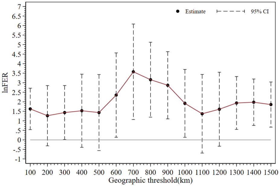
Full sample space spillover effect fluctuation chart.
Heterogeneous Spatial Spillover Effect Volatility
Population Heterogeneity
Testing for population heterogeneity is necessary before conducting a fluctuation test of the spatial spillover effect of population heterogeneity. In this study, regions east of the Hu Huanyong Line (Heihe-Tengchong population demarcation line), widely used in academia, are defined as densely populated areas, and regions to the west as sparsely populated areas. Based on this, regional heterogeneity tests were conducted and the results are presented in Table 9.
Test Results of the Spatial Spillover Effects of Population Heterogeneity.
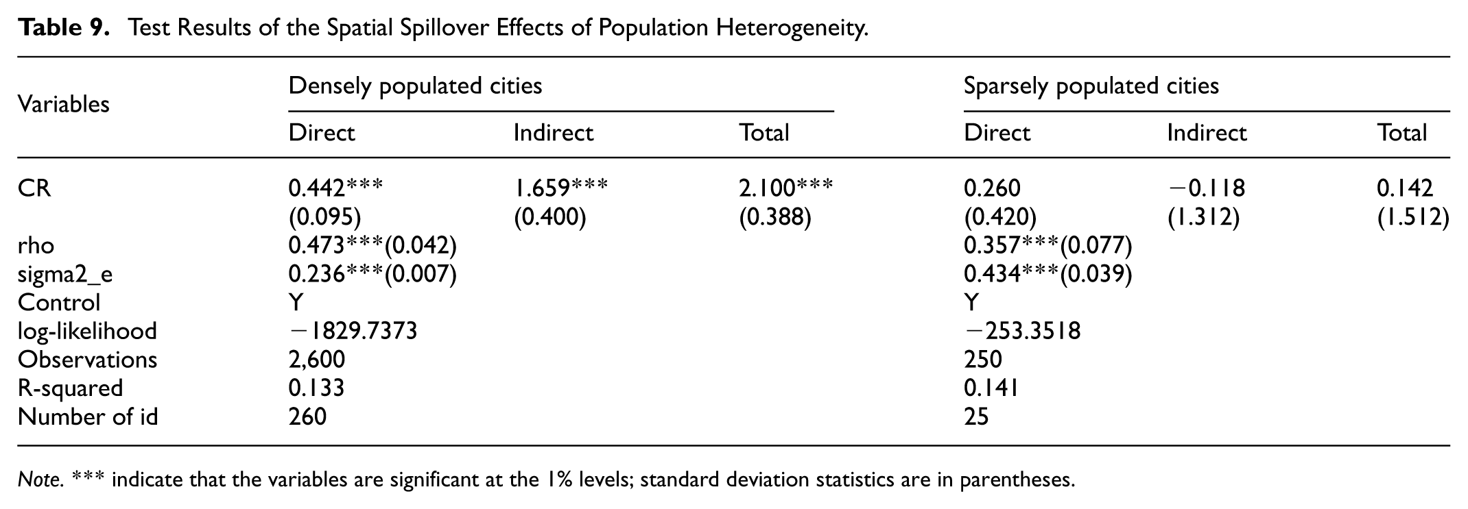
Note.*** indicate that the variables are significant at the 1% levels; standard deviation statistics are in parentheses.
Based on the data in Table 9, it can be observed that at the aggregate level, CR in densely populated areas has a significant and positive impact on local GECs and exhibits spillover effects; this positive effect is not evident in sparsely populated areas. This outcome supports the investigation of whether the impact varies across geographical distances.
Figure 5 analysis reveals that in densely populated areas, the relationship between the spatial spillover effect of CR and the geographical distance threshold is similar to the trend of the overall spatial spillover effect. When the threshold was set at 100 km, CR had a significant positive impact on GEC, followed by an insignificant effect; over 600 to 1000 km, the positive spillover effect of CR increased and reached a peak at 700 km, after which the significance gradually decreased; subsequently, beyond a distance of 1300 km, the positive spillover effect of CR became significant again. The results indicate that in densely populated areas, there exist multiple specific geographic distance ranges within which climate risks from other regions can significantly elevate local governments' attention to environmental issues, a finding consistent with the full-sample tests. In sparsely populated areas, the significant spillover effects are concentrated within the medium-to-long distance range of 300–1200 km, where CR exerts a more geographically focused positive influence on GEC. This demonstrates that in regions with lower population density, there exists a relatively continuous geographic distance range wherein climate risks from one area can prompt neighboring governments to prioritize environmental concerns. The findings reveal how population distribution disparities lead to corresponding variations in impact patterns, thereby validating Hypothesis H3.

Population heterogeneity spatial spillover effect fluctuation charts.
Resource Endowment Heterogeneity
Based on the “National Sustainable Development Plan for Resource-based Cities (2013–2020),” this study classified 285 prefecture-level cities into 112 resource-based and 173 non-resource-based cities, and investigated whether the impact of climate risk on cities with different resource endowments supports a fluctuation test of spatial spillover effects under geographical thresholds.
The results shown in Table 10 indicate that at the 1% significance level, CR exhibited significant positive local and spatial spillover effects across various types of cities, although the coefficients differed, allowing for the examination of fluctuations in spatial spillover effects.
Resource Endowment Heterogeneity Test Spatial Spillover Effect Test Results.

Note.*** and ** indicate that the variables are significant at the 1% and 5% levels, respectively; standard deviation statistics are in parentheses.
Figure 6 shows that the relationship between the spatial spillover effect of climate risk and the corresponding geographical distance threshold can be divided into two intervals in non-resource-based cities. One is the close-range impact interval within 200 km, and the other is the medium-range interval of 700 to 900 km, where climate risk had a significant positive spillover effect on GEC at the 10% level. The results indicate that in non-resource-based cities, local climate risks contribute to the increased usage of environmental protection-related terminology in government work reports by other prefecture-level governments within close and medium distances. In contrast, among resource-based cities, the positive spatial spillover effects of CR on GEC are statistically significant across all distances from 100 km to 1500 km. This finding demonstrates that climate risks faced by any resource-based city can significantly elevate environmental protection awareness in government agendas across a broad range of neighboring cities. The observed variation in how geographic distance mediates climate risks' impact on governmental environmental attention, depending on city type, provides empirical validation for Hypothesis H4.

Resource endowment heterogeneity spatial spillover effect fluctuation chart.
Conclusions and Policy Recommendations
Conclusions
This study utilized panel data from 285 prefecture-level cities in China during 2013–2022, employing the Spatial Durbin Model as the primary analytical approach to investigate the impact and mechanisms of CR on GEC at the prefecture-level city scale from a spatial spillover perspective. The study investigated how this influence varies with geographical distance and conducted heterogeneity analysis through subsample regression methods from the perspectives of population distribution and resource endowment. The main findings are as follows:
CR significantly enhances GEC and exhibits positive spatial spillover effects. Studies by Zhang et al. (2023), Li and Li (2025), and Xie and Li (2024) also confirmed the existence of spatial spillover effects in climate risk research across various dimensions. Empirical results demonstrated that local CR not only prompts local governments to prioritize environmental protection but also motivates other cities to increase their focus in this regard. The most direct manifestation is the increased frequency of environment-related terms in government work reports.
Using a spatially weighted matrix based on gradually varying geographical distances, this study established that within the range of 100–1500 km, the impact of CR on GEC is significant across multiple specific geographical distance thresholds, while the positive effect is insignificant in other distance ranges. This indicates that climate risk in one region can elevate environmental concern among governments within a certain geographical scope, with the spillover effects of climate risk on government behavior displaying nonlinear characteristics across distances.
The fluctuation in the impact of CR on GEC due to geographical distance variations differs among cities with distinct population and resource characteristics. This suggests that the scope of influence of local climate risk on other cities' governments regarding heightened environmental concern varies depending on population density and resource endowment.
Policy Recommendations
China's hybrid governance system organically integrates central supervision with local autonomy, granting prefecture-level cities considerable discretionary power in environmental policy formulation. These decisions, or the lack thereof, may generate spillover effects that extend beyond local jurisdictions, impacting surrounding regions, which is crucial for developing effective multi-level climate governance strategies. This study examined how climate threats shape local environmental priorities and whether such concerns exhibit spatial diffusion, thereby providing theoretical and empirical foundations for establishing a regional collaborative policy governance system and promoting joint governance across multi-level governments. It deepens the understanding of the dynamic coupling relationship between climate risks and government policies. Based on these findings, the study proposes the following policy recommendations:
Governments inherently bear the responsibility to prevent meteorological disasters from causing loss of life and property among citizens. Given that climate risks can influence government's attention to environmental issues, and considering the unique "promotion tournament" style intergovernmental interaction mechanism within the Chinese government, it is necessary to further refine existing assessment criteria for evaluating local governments' environmental performance in light of the close correlation between climate change, its extreme events, and human economic activities. For example: 1) Increase the weight of air quality assessments; 2) Add assessment indicators for government preparedness against natural disasters. Simultaneously, the interaction mechanism between government and market can be utilized: For climate risks with short-term suddenness and widespread impact, such as extreme precipitation and temperatures, local governments can establish special funds and policies, as well as engage in intergovernmental cooperation to address their respective shortcomings. This would enhance the risk resilience and post-disaster recovery capabilities of economic entities like enterprises, thereby strengthening economic stability. Lessons can be drawn from African countries' experience in establishing special funds to promote resilience upgrades in food systems. As for air quality, a long-term and pervasive climate issue, sustained government attention and market collaboration are required. Appropriate subsidies can be provided for measures that improve air quality, such as corporate green transitions and afforestation. Drawing from the experience of China–Pakistan joint photovoltaic patent pools, an intercity technological cooperation system can be established.
Under changes in geographical distance, this study established that local climate risks can influence the environmental attention of governments in other regions over long distances, but this effect is constrained within certain geographical ranges. Therefore, to address constraints such as local protectionism and the coordination capacity of prefecture-level governments, measures such as cross-regional cooperation mechanisms and multi-level government coordination mechanisms can be implemented: 1) Leveraging highly mature internet technologies to establish cross-regional platforms for meteorological early warnings, policy coordination, joint environmental law enforcement, and fund sharing, accelerating information transmission and factor mobility, reducing local governments joint actions costs, and improving intergovernmental cooperation efficiency; 2) Establishing higher-level intra-governmental coordination agencies to curb local protectionism among regional governments, and expanding the functional authority of existing cross-regional intergovernmental coordination organizations to avoid increased costs and personnel redundancy.
Under different population distributions and resource endowments, changes in geographical distance led to varying impact patterns, necessitating differentiated governance. For densely populated areas, in addition to the internet platforms mentioned above, the proactive involvement of higher-level governments should be further enhanced, by amongst others, increasing assessment criteria for higher-level governments or introducing corresponding policy support from the central government. For sparsely populated regions, due to the vast areas of individual prefecture-level cities and differences in natural geographical environments, higher-level governments can leverage their resource advantages to organize expert assessments of regional characteristics and establish frameworks that balance local features while enabling interregional cooperation. Existing intergovernmental cooperation organizations such as the Digital Silk Road Cloud, the Southwest Geological Disaster Joint Prevention System, and the Interprovincial Consultation and Cooperation Mechanism for the Upper Yangtze River can serve as models. Given that climate risks in resource-based cities have already prompted widespread increases in environmental attention among governments, the focus should shift to non-resource-based cities. In addition to increasing higher-level government involvement and building internet platforms, the following measures can be considered for non-resource-based cities, which are relatively economically developed and densely populated: 1) Further implement the National Climate Change Adaptation Strategy 2035 and expand the scope of climate-resilient city construction; 2) To avoid radical policies like Switzerland's "Mandatory Building Photovoltaic Order" or significant policy fluctuations as seen in the U.S. Build Back Better Act, the current policy evaluation system should be improved to ensure applicability, and a monitoring mechanism should be introduced at an appropriate time to guarantee stable policy implementation; 3) More developed regions can learn from Belarus' "Nuclear Energy Replacement + Wetland Restoration" model by leveraging the common characteristics of nuclear power generation and natural geographical conditions, and jointly address climate risks through large-scale intergovernmental cooperation in environmental engineering projects.
Limitations and Future Research
This study innovatively constructed a spatial threshold model based on geographical thresholds and applied traditional spatial econometric models. It systematically examined how the spatial spillover effects of climate risks on government environmental policies fluctuate with changes in geographical distance from three dimensions: overall effects, population heterogeneity, and resource endowment heterogeneity. The aim of this research was to provide a reference for local governments in China to jointly address climate risks and achieve sustainable development, as well as policy recommendations. Furthermore, the findings may provide guidance for other countries facing climate risks and green transformation. However, considering the potential multidimensionality of climate risk impacts on government actions, this study did not investigate whether other potential factors might interfere with this impact or determine the effects at provincial and county levels. Additionally, due to limitations in data acquisition, the climate risk indicator system needs further improvement. Considering these research limitations, future scholars should conduct more in-depth studies.
Footnotes
Author Contributions
Conceptualization, M.R. and Z.Y.; methodology, M.R. and H.K.W.; software, M.R.; validation, Z.Y., G.C. and H.K.W.; formal analysis, Z.Y., H.C. and H.K.W.; investigation, M.R. and Z.Y.; resources, G.C. and H.C.; data curation, M.R. and Z.Y.; writing—original draft preparation, M.R. and G.C.; writing—review and editing, G.C., H.C., Z.Y. and H.K.W.; visualization, M.R.; supervision, H.K.W.; project administration, H.K.W., H.C. and Z.Y.; funding acquisition, H.K.W., H.C. and G.C.. All authors have read and agreed to the published version of the manuscript.
Funding
The authors disclosed receipt of the following financial support for the research, authorship, and/or publication of this article: This research was funded by the program of Research on High-Quality Development of Contemporary Chinese Manufacturing [No.: FJ2023BF089], Fujian Provincial Social Science Foundation Project [No.: FJ2024C025] and the research project “Exploring the Path of Regional Sustainable Development and Common Prosperity in China under the Background of Digital Economy” of Macao Polytechnic University.
Declaration of Conflicting Interests
The authors declared no potential conflicts of interest with respect to the research, authorship, and/or publication of this article.
Data Availability Statement
No new data were created or analyzed in this study. The data that support the findings of this study are available on request from the corresponding author upon reasonable request.
Institutional Review Board Statement
Not applicable.
Informed Consent Statement
Not applicable.