
Abstract
In this study, we utilize regional public facilities as the factors of evaluation criteria, apply buffering and weighted overlay analysis in GIS as the multi-criteria spatial information analysis tools, and take the Lanyang Plain, Yilan, Taiwan as the test area for the optimal facility location analysis of tourism industry. We take the “optimal service/influence distance” of each regional public facility from literature review as the radius of neighborhood for buffering and build the buffer objects in GIS. The process of weighted overlay analysis is conducted by using grid method. After a series of grid size testing, we find that while the grid size decreases to 320 m × 320 m, the distribution of grids with weighted overlay values is close to the distribution of all the buffer objects mentioned above. The distribution of grids with higher weighted overlap values obviously presents the optimal facility location of tourism industry that is apparently consistent with the distribution of the famous tour sites or facilities of tourism industry and the four to five star hotels. Therefore, we conclude that this optimal facility location model of tourism industry should be quite suitable for land use or site selection planning of tourism and relative industries.
Introduction
Using geospatial parameters such as factors of regional public facilities to analyze the facility location of tourism industry is originally a process of Multi-Criteria Evaluation (MCE; Albuquerque et al., 2018; Rong, 2005; Y. J. Tsai & Fang, 2015; B. C. Zhang & Lin, 2007). And for the topic of such multi-criteria geomatics analysis, the utilization of geographic information system (GIS) technology often make the combination of regional geographic features and tourism potential to be possible (Chang et al., 2008; R. J. C. Chen, 2007; C.-H. Tsai & Yeh, 2016; B. C. Zhang & Lin, 2007).
The primary objective of the current study on environmental planning was to analyze the differences in the geospatial distribution of natural resources and physical environment as well as the potential of and restrictions on the use of land resources (X. L. Wang & Zhuang, 1995). The ultimate goal of land resource utilization is the effective distribution of space utilization for various land use activities in different locations (Y.-C. Wang, 1992; X. L. Wang & Zhuang, 1995). The use of natural resources and physical environment for tourism and recreation is a land use activity that is most commonly expressed in terms of spatial patterns (X. L. Wang & Zhuang, 1995). In addition, related facilities such as airports, high-speed rail stations (Chi et al., 2005), railway stations, mass rapid transit or light rail stations, cruise terminals, tourist hotels, theme parks, restaurants, and souvenir shops can be used to develop the tourism and recreation industry (H. Z. Huang, 2018), which also form the most realistic manifestation of the tourism industry in terms of land use (J. Y. Lin, 2004). However, tourism facilities (e.g., tourist hotels and theme parks) are often limited by considerable environmental constraints, high infrastructural costs, and inability to be relocated (B. C. Chen, 2002). Tourism facilities that are built by utilizing the geographical convenience provided by relevant regional public facilities are more advantageous and allow foreign tourists to explore the place. Therefore, based on the concept of sustainable tourism (Chi et al., 2005; Ramsamy, 1994), the adoption of long-term and high-tech environmental planning in limited space can improve the satisfaction of local residents and foreign tourists and provide a reference for the location of facilities in tourism industry development. The main research objective was to use the viewpoints and indicators of land use along with GIS to conduct a spatial analysis of the optimal facility location and compare the analysis results with the current state of tourism facilities in the test area.
Chi et al. (2005) divided the factors affecting land use into natural disasters and location conditions based on the studies of Howard and Remson (1978) and Pan (1999). Both studies used a two-phase expert questionnaire and an analytic hierarchy process questionnaire survey (Saaty, 1980) and specifically proposed a set of evaluation model that was applicable to Taiwan’s alluvial plain regions to objectively determine the land use potential. In the model, the sub-factors under natural disasters were floods, land subsidence, liquefaction, and soft ground; whereas the sub-factors under location conditions were transportation facilities, public facilities, and undesirable facilities. However, numerous relevant studies (Byers, 1990; C. K. Chen, 1995; R. J. C. Chen, 2007; G. Y. Chen & Xie, 2001; Y. L. Ding et al., 2016; Go & Zhang, 1997; Y. W. Huang, 2008; Li, 1997; J. Y. Lin, 2004; Rong, 2005; Y. J. Tsai & Fang, 2015; Yang & Su, 2011; Ye, 2009; Zheng, 2007; Zhong, 2006) have mostly used location conditions as the evaluation criteria for land use or location selection in the tourism and recreation industry. Among them, transportation and public facilities were the pull objectives of the push–pull location decision (Bruno et al., 2014; Eiselt & Laporte, 1995), whereas undesirable facilities formed the push objectives (Xia et al., 2005). Chi et al. (2004, 2005) further noted that transportation facilities (e.g., transportation hubs and interchanges), undesirable facilities (e.g., outdoor electrical substations and sewage treatment plants), and various types or functions of urban public facilities (e.g., schools and parks) were in the scope of regional public facilities. Because these public facilities have a certain degree of effects such as service (positive effect) and influence (negative effect) with the distance on the adjacent land use and tourism and recreation environment (Y. Q. Lin, 2002; Haley et al., 2005; Shi et al., 2000), the studies further used an expert questionnaire with the fuzzy Delphi method (Ishikawa et al., 1993) and applied Max–Min and fuzzy integral methods to integrate different opinions from experts. The results revealed a set of optimum service/influence distances for regional public facilities applicable for the evaluation of land use potential in Taiwan’s alluvial plain regions, including six transportation facilities (e.g., mass rapid transit station), eight public facilities (e.g., urban parks), and nine undesirable facilities (e.g., thermal power stations), as shown in Table 1. Subsequently, based on the aforementioned factors, follow-up planning recommendations were proposed for the specific area of Tainan High Speed Rail Station that also formed a part of the tourism facilities (H. Z. Huang, 2018). Therefore, this study hypothesized that the optimal service/influence distance of public facilities can also be applied to land use or even site selection analysis in other tourism industry–related plans if supplemented by appropriate analysis models. And the primary research limitation of this study was stated as follows. Given that the previously established regional public facility indicators and the test area in this study were all located on Taiwan’s alluvial plain region, the facilities in regions such as coastlines, rock shores, hills, and mountains would not be considered temporally in this study.
Optimal Service/Influence Distance of Regional Public Facilities Applicable to the Land Use Potential Evaluation in Taiwan’s Alluvial Plain Regions.
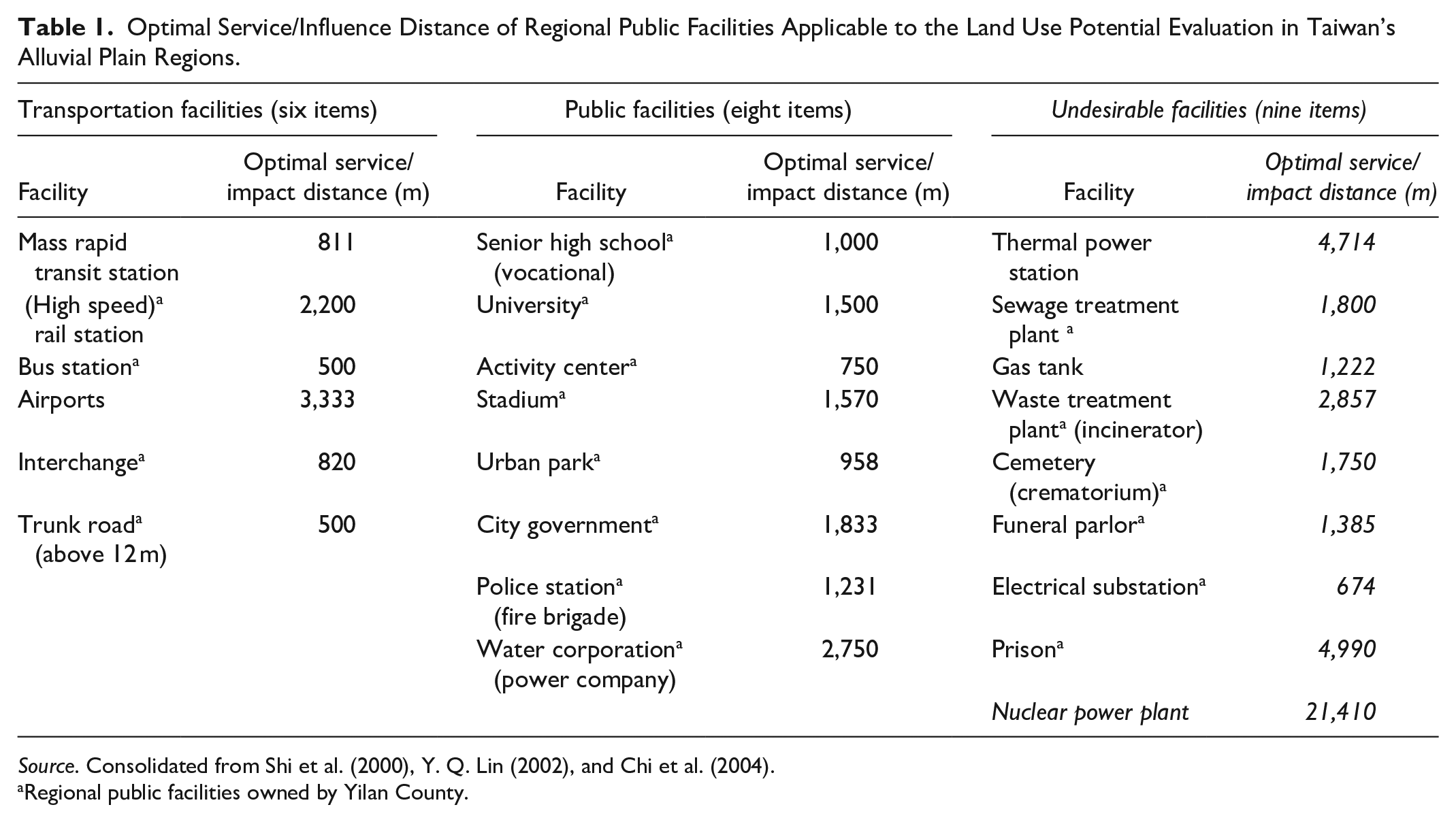
Source. Consolidated from Shi et al. (2000), Y. Q. Lin (2002), and Chi et al. (2004).
Regional public facilities owned by Yilan County.
From the perspective of location theory, the use of the optimal service/influence distance of regional public facilities to explore the optimal facility location compared with tourism facilities is categorized as the “Location Set Covering Problem (LSCP).” The purpose of a LSCP is to pursue cost minimization of the future facility configuration under the condition that all demand points are covered within the reasonable service range of the facilities (Toregas et al., 1971; Zeng et al., 2014; K. Zhang & Zhang, 2015). However, the existing regional public facilities were used to define the distribution of relevant locations for reducing the distance cost from regional public facilities to the tourism and recreation industries (demand points) during site selection, which can be considered a reverse application of the location set covering problem in this study.
Taiwan has strongly promoted its tourism industry policies since about 2000 (Y.-C. Wang, 2000). For example, the “Project Vanguard for Excellence in Tourism” implemented in 2009 and the “Taiwan, touch your heart” implemented in 2011 aimed to achieve the goal of developing international tourism, improving the quality of domestic tourism, and increasing foreign exchange income as well as showcasing the new charm of tourism in Taiwan to the world and achieve the vision of “Taiwan-The Heart of Asia” (Y. J. Tsai & Fang, 2015). Nonetheless, Taiwan is small in area and densely populated, and many high tourist potential areas are often crowded with people and vehicles. In terms of domestic tourism, according to the 2017 Survey Report on Visitors Expenditure and Trends in Taiwan by the Tourism Bureau of the Ministry of Communications (2018), Jiaoxi Hot Spring in Jiaoxi Township, Yilan County, ranked third among tourist bases with a high visiting rate by locals. Moreover, Jiaoxi Hot Spring ranked the first among the highest visited hot spring areas, with a total of 5.33 million visits, which was higher than the 4.74 million visits to Sun Moon Lake in Yuchih Township, Nantou County. This finding revealed that Jiaoxi Hot Spring has a high tourist potential, and therefore, the Yilan Plain, where Jiaoxi Hot Spring is located, was selected as the test area in this study.
The Lanyang Plain is located in the northeastern corner of Yilan County in northeastern Taiwan (Figure 1). It is an alluvial plain in the shape of an equilateral triangle formed by the alluvial accumulation of the Lanyang River and its tributaries, with a length of approximately 30 km on each side and an approximate area of 320 km2. The three apex townships are Toucheng Town, Sanxing Township, and Su’ao Township (red ellipses in Figure 1). The major population is concentrated at Yilan City and Luodong Township (within Yilan Plain), and Jiaoxi Hot Springs, the considerable tourist potential, is located in the north corner of the Yilan Plain (Figure 1). Jiaoxi Hot Spring is the only plain-type hot spring in Taiwan (Lu, 2015). Its water contains sodium bicarbonate with a temperature of approximately 50°C, and it is used for bathing and drinking. In addition, the local residents use it for breeding and farming. After promulgation of the Hot Spring Act on July 2, 2003, an epoch-making legal management system was established in Taiwan’s hot spring areas. The establishment of hot spring water resources was categorized into public goods by the Hot Spring Act. In recent years, the Yilan County Government has made considerable efforts toward the reconstruction and development of Jiaoxi Hot Springs, with its crucial public works including rezoning of Tangweigou and renovation of the Hot Spring Park. In terms of cityscape, many old buildings are now being restored. In addition, Jiaoxi Township organized various hot spring activities, which not only promoted sightseeing but also enabled the selection of Jiaoxi Township as one of the top 10 tourist visited towns in Taiwan in 2012: Jiaoxi Hot Springs Health and Living Town. With the opening of the Xueshan Tunnel and the National Freeway No. 5 in 2006, the transportation time between Taipei and Yilan has been shortened, which has resulted in Jiaoxi Hot Springs and the entire Yilan County being crowded with tourists throughout the year (Lu, 2015).

Topographic (left) and administrative district (right) maps of Yilan County and Jiaoxi Township.
Therefore, this study will consider Yilan Plain as an example and analyze the optimal facility location for the tourism industry by applying the aforementioned optimal service/influence distances of the regional public facilities obtained from land use literature (Table 1). Moreover, this study will also apply GIS technology to compare the land use factors associated with tourism facility location.
Literature Review
Effect of Regional Public Facilities on the Facility Location of Tourism Industry
Tourism facilities originally form a part of land use, and regional public facilities are an essential factor affecting land use. Therefore, regional public facilities have a certain effect on the tourism facility locations. Domestic and global studies on the effect of regional public facilities on tourism facility locations are diverse. Shimizu and Okamoto (2022) elaborated that the national government usually needs to construct public infrastructure such as water supply, sewerage systems, ports, airports, parks, highways, etc. for the tourism industry to create employment opportunities and attracts foreign currency. Islam and Akter (2021) also suggested that developing infrastructure such as accommodation facilities, restaurants, transportation facilities (airport, railway, etc.), ensuring security, taking more promotional activities, reducing the cost of touring, etc. to satisfy tourist interest can really be helpful for the tourism industry in Bangladesh. Khan et al. (2020) found that the major factors which affect the tourism industry and even the global economy were as peace, natural beautification, transportation facilities, hospitality, good attitude of the population, and historical places. In addition, Y. J. Tsai and Fang (2015) noted that strategic location selection such as proximity to railway stations and places with many parking lots affected the operating performance of international tourist hotels. Y. L. Ding et al. (2016) also revealed that convenience of transportation and parking and distance from public facilities are crucial criteria for selecting the location of a homestay. G. Y. Chen and Xie (2001) used a questionnaire survey with the analytic hierarchy process to establish a leisure hotel location indicator at the international level. The findings revealed that the distance from the base to the airport, station, and city center ranked first among the indicators. Go and Zhang (1997) also identified that factors such as transportation accessibility, location attractiveness, and attractiveness of surrounding attractions of the Beijing International Convention Center in China affected the crowds in that area. Both C. K. Chen (1995) and J. Y. Lin (2004) stated that the evaluation and planning of regional tourist towns should integrate transportation-related facilities and organizations (e.g., aviation, shipping, railways, highways, tour bus services, and yacht operators), local or federal public facilities, local schools at all levels, and other resources and services. In addition, Zheng (2007) found that site selection at the Kaohsiung Museum of Labor should be made by considering factors such as the status of public transportation facilities (e.g., roads, railways, airports, and ports) and regional public facilities (e.g., schools, markets, parks, and parking lots). Zhong (2006) used GIS to calculate the percentage of population within the service area based on the service radius of different parks to examine the service level of parks in Hualien City. Moreover, R. J. C. Chen (2007) used GIS as a site selection tool and observed that the number of tourists in the vicinity of parks, highways, aviation, railways, ports, and roads significantly increased. Byers (1990), Li (1997), and Yang and Su (2011) noted that undesirable facilities affected the quality of life of residents in nearby areas, endangered their safety and health, and reduced the property values, thereby affecting the local tourism facility locations (Y. W. Huang, 2008). However, these undesirable facilities are necessary for the operation of the entire society. Rong (2005) used a multicriteria evaluation to select the location of a funeral. He found that the general public had the belief of “never-in-my-backyard” in terms of undesirable facilities such as thermal power plants, sewage treatment plants, gas tanks, gas stations, waste treatment plants (incinerators), cemeteries (crematoriums), funeral parlors, columbariums, electrical substations, prisons, nuclear power plants, and nuclear waste storage sites. Ye (2009) concluded that a successful casino setting must have location conditions related to transportation, geographic location, tourism resources, and public facilities. She also asserted that the Qijin District of Kaohsiung City is the optimal choice. However, Y. W. Huang (2008) noted that residents of Taiwan, Penghu, and its outlying islands did not want casinos to be built near their residential areas. In summary, regional public facilities have a considerable effect on tourism facility locations. Therefore, this study proposed that the optimal service/influence distance of regional public facilities proposed by Shi et al. (2000), Y. Q. Lin (2002), and Chi et al. (2004) can be applied to the analysis of tourism facility location in Taiwan’s alluvial plain area by using the land use potential evaluation function.
GIS Multicriteria Decision Analysis
GIS analysis can be used for identifying suitable locations for the development of tourism facilities or activities and confirming suitable locations for the construction of tourist hotels or tourist centers (Kadivar et al., 2016). GIS is a set of tools for storing, processing, analyzing, and displaying digitized geographic information (Albuquerque et al., 2018; Burrough, 1986), and it was first applied to the field of tourism management planning in the early 1990s. Currently, numerous studies on tourist locations have proved that the application of multicriteria evaluation combined with GIS for multicriteria decision analysis was highly efficient (Kadivar et al., 2016). For example, B. C. Zhang and Lin (2007) applied GIS-based multicriteria decision analysis to the optimal tourism location analysis in former Kaohsiung City before the merger of counties and cities. Geneletti (2008) applied the method to analyze the suitability of a newly established ski resort in Trentino in northern Italy. Huntley (2010) used it to select suitable paths for bicycle lanes in Toowoomba, Queensland, Australia; and Jovanović and Njeguš (2008) used it to measure and evaluate tourism resources for the development of Zlatibor and Zlatar in Serbia.
Various GIS software are available on the market, such as MapInfo Professional, ESRI ArcGIS, and QGIS (Halim et al., 2018). The Mapinfo Professional is a common GIS software on the market, relatively cheap, and easy to get started (Vasiutynska et al., 2018). This study applied the functions of spatial digital mapping and relational database operations of MapInfo Professional to efficiently perform digital editing of point, line, and area objects and to present data through zoning, buffering, overlay, colored ranges, diagrams, and thematic maps (Precisely MapInfo Pro, 2022; Skorbiłowicz & Skorbiłowicz, 2016).
Research Methods
Buffering and Overlay Analysis
The efficient spatial information and attribute database editing function of GIS allows for the rapid modification, addition, and removal of multicriteria spatial information. GIS can also be applied to the visual display of spatial location analysis results through pictures or maps. Chang et al. (2008), Jovanović and Njeguš (2008), and Albuquerque et al. (2018) noted that the built-in buffering and overlay analysis tools of GIS software were the optimal introductory analysis tools for multicriteria land resource planning or tourism location analysis. Buffering uses a certain geographical feature point (e.g., line and area) as the center, distance of a certain feature or requirement called the radius of neighborhood to draw a circle around the point (line or area), and the area range obtained by the circle drawing as the desired buffer zone. Overlay analysis is used to superimpose two or more sets of different spatial information objects under the same reference coordinate system and generate new spatial information and attribute data (Z. Ding et al., 2018). The “weighted overlay analysis” involves assigning specific “weights” to spatial information objects based on the relative importance of a feature or effect (Kaliraj et al., 2015).
In this study, point objects of the aforementioned regional public facilities was considered geographical feature points, and a buffer zone circle was drawn by taking their optimal service/influence distance as the neighborhood radius. Subsequently, the “buffer polygon objects” obtained from the circle was further subjected to “weighted overlay analysis” to obtain the distribution of the most optimal tourism facility location (please see 4.2.2 for detail).
Expert Questionnaire: Weights Setting
Shi et al. (2000), Y. Q. Lin (2002), and Chi et al. (2004) highlighted the effects of regional public facilities on land use through an expert questionnaire. Based on the literature review, this study hypothesized that these regional public facilities have varying degrees of effect on the tourism facility locations. Therefore, this study evaluated the relative degree of effect of each regional public facility on the tourism facility location by using an expert questionnaire. The determined “relative degree of effect” was used as the weights of the buffer polygon objects.
This study designed a simple expert questionnaire titled, “Evaluation of the relative effect of regional public facilities on tourism facility locations.” The questionnaire was mainly divided into a score column and question column. For example, the question, “Do you think urban parks will affect the tourism facility location?” could be rated to have exceptionally positive effect (5 points), positive effect (3 points), slightly positive effect (1 point), no effect (0 point), slightly negative effect (−1 point), negative effect (−3 points), and exceptionally negative effect (−5 points; Y. C. Chen et al., 2011; Yao, 2011). This study conducted a simple evaluation and selected experts, scholars, and workers from the field of tourism, recreation, and land resource utilization for the questionnaire survey (Y. C. Chen et al., 2010; Green, 2014; Scheele, 1975). After the completed expert questionnaires were collected, the scores were summed according to various regional public facilities, and the mean and standard deviation were calculated, which represented the relative degree of effect of various regional public facilities on the tourism facility locations (i.e., used as weights for subsequent weighted overlay analysis).
Results and Discussion
Results of Expert Questionnaire Survey
A total of 40 expert questionnaires were issued and collected, with a response rate of 100%. The selected experts comprised 14 official representatives from the field of tourism and recreation, 5 hot spring operators, 15 official representatives from the field of land resource utilization, and 6 workers from the field of land resource utilization (Y. C. Chen et al., 2011; Yao, 2011).
The results of the expert questionnaire survey are presented in Table 2. The mean of the six transportation facilities ranged from 2.59 (interchange) to 4.51 (mass rapid transit station), and the standard deviation ranged from 1.10 to 1.76. The convergent standard deviation indicated that experts agreed that transportation facilities positively to exceptionally positively influenced tourism facility locations. Among the eight public facilities, the mean and standard deviation of the water corporation (power company) facility was −1.10 and 1.45–1.87, respectively, and the mean of the other seven public facilities ranged from 0.38 (police station and fire brigade) to 3.05 (urban park). These results indicated that experts believed that public facilities had a slightly positive to positive effect on tourism facility locations. The water corporation (power company) may be considered to have a slightly negative effect on tourism facility locations because of people’s poor perception of electrical substations (Hu, 2015). Furthermore, the mean of the nine undesirable facilities ranged from −4.33 (cemetery and crematorium) to −2.85 (prison), with a standard deviation of 1.15–2.25. These results indicated the experts’ belief that undesirable facilities had a negative to exceptionally negative effect on tourism facility locations.
Results of the Expert Questionnaire on the Relative Effect of Regional Public Facilities on Tourism Facility Locations.

Source. Consolidated from Yao (2011) and Y. C. Chen et al. (2011).
Regional public facility owned by Yilan County.
Results of the GIS Multicriteria Decision Analysis
Buffering analysis results
The GIS multicriteria decision analysis in this study considered the entire Yilan County, focusing on the Yilan Plain. Yilan County comprises four transportation facilities, including (high speed) rail stations, bus stations, interchanges, and trunk roads; eight public facilities such as senior high schools (vocational), universities, activity centers, stadiums, urban parks, city government, and police stations; and six undesirable facilities including sewage treatment plants, waste treatment plant (incinerator), cemeteries (crematoriums), funeral parlors, electrical substations, and prisons. The buffering analysis results are presented in Figure 2. Most of the 18 regional public facilities in Yilan County were distributed in the township located in the Yilan Plain (Figure 1), and few were distributed in Datong Township and Nan’ao Township, which had larger areas and were located between Xueshan Range and Central Mountain Range. Figure 2a illustrates the distribution of buffering objects of transportation facilities. The buffering objects of the high-speed rail station were distributed in a strip mainly on the western coast of Yilan County. Figure 2b and c display the distributions of buffering objects of public facilities. Among them, the buffering objects of the police station and fire brigade were widely distributed in a strip in the densely populated areas of Yilan County, which was considered most popular among tourists. Finally, Figure 2d and e depict the distributions of buffering objects of undesirable facilities. The buffering objects of the cemetery (crematorium) were widely distributed in a strip in the periphery of the densely populated area of Yilan County, whereas those of other facilities showed a relatively scattered distribution in a smaller area.

Buffering analysis results of 18 regional public facilities in Yilan County. (a) illustrates the distribution of buffering objects of transportation facilities. The buffering objects of the high-speed rail station were distributed in a strip mainly on the western coast of Yilan County. (b) and (c) display the distributions of buffering objects of public facilities. Among them, the buffering objects of the police station and fire brigade were widely distributed in a strip in the densely populated areas of Yilan County, which was considered most popular among tourists. Finally, (d)and (e) depict the distributions of buffering objects of undesirable facilities. The buffering objects of the cemetery (crematorium) were widely distributed in a strip in the periphery of the densely populated area of Yilan County, whereas those of other facilities showed a relatively scattered distribution in a smaller area.
Although most regional public facilities were not adjacent to each other and some even at a distance apart, some nonadjacent regional public facilities had overlapping effects on the tourism facility locations after their spatial effects were expanded through buffering. Moreover, locations in these overlapping areas will become the most optimal tourism facility locations if these overlapping buffering zones have more positive effects on tourism. Therefore, to further analyze the suitability of tourism facilities at the spatial level, this study applied the weighted overlay analysis to perform the buffering of 18 regional public facilities in Yilan County.
Results of the weighted overlay analysis
The weighted overlay analysis conducted in this study used the mean of the degree of effect of regional public facilities on tourism facility locations obtained using expert questionnaires as the weights of the regional public facilities buffering objects generated during the buffering. The weighted overlay process was performed using the grid method as follows. (1) The local tangent plane coordinates were first used to identify a square grid that can cover the entire Yilan County, and the side length equation was set as (a × bn) m, where a is a real number >0, b is a positive integer ≥2, and n is a positive integer ≥0. As shown in Figure 3, this study used a maximum grid side length of (5 × 214) = 81,920 m for the analysis. In the side length equation, b = 2 indicates that the grid side length reduction ratio is 1/2, that is, the side length of the second largest grid is half the side length of the largest grid, and so on. (2) The weights of all overlapped regional public facility buffering objects in the grid were summed, and the sum value was used as the weighted overlay weight of the grid. Take a grid with side length (5 × 212) = 20,480 m as an example (Figure 3). The grid shown in Figure 3a contains overlapped buffering objects of trunk roads (weight = 3.00), police stations and fire brigades (weight = 0.38), and cemeteries and crematoriums (weight = −4.33), so the weight of the weighted overlay is [3.00 + 0.38 + (−4.33)] = −0.95. The grid in Figure 3b contains overlapped buffering objects of trunk roads (weight = 3.00), high speed rail stations (weight = 3.41), stadiums (weight = 2.54), urban parks (weight = 3.05), police stations (weight = 0.38), and cemeteries and crematoriums (weight = −4.33), so the weight of weighted overlay is [3.00 + 3.41 + 2.54 + 3.05 + 0.38 + (−4.33)] = 8.05.

Grid-weighted overlay analysis of 18 regional public facilities in Yilan County.
The weighted overlay analysis by using the grid method revealed that the grid distribution with weighted overlay weights will be closer to the distribution of buffering objects in all regional public facilities when the side length of the grid is smaller, as shown in the grid distribution with a side length of 2,560 m in Figure 3. Considering the grid side length equation (5 × 2n) used in this study, the smallest grid side length can be (5 × 20) = 5 m. Excessively large grids are unsuitable as they affect the image resolution and generated pixelated data, which hinders data interpretation. Although a smaller grid can yield more accurate spatial distribution results, an excessively small grid greatly reduces the computational efficiency of GIS. Therefore, this study narrowed down the scope and conducted the “optimal grid size” test on the Yilan Plain.
As shown in Figure 4, the Yilan Plain is approximately a triangular area surrounded by three apexes at Toucheng, Fushan, and Gangbian police stations. The grid used in this study had seven side lengths of 10,240, 5,120, 2,560, 1,280, 640, 320, and 160 m. This study divided the maximum and minimum weighted overlay weights in each grid into 10 equal ranges for layer tinting (red to green), as shown in Figure 4a–g. In addition, the weighted overlay distribution maps (Figure 4a–g) for each grid size represented the tourism facility suitability. According to Figure 4h, as the grid size shrinks, the maximum and minimum weights of the weighted overlay become larger and smaller, respectively. Up to a grid size of 320 m, the maximum and minimum weighted overlay weights remain stable (Figure 4h), and the buffering appearance of all overlapped buffering objects in Figure 3 is observed in the weighted overlay weight distribution (Figure 4e–g). When the grid size shrinks below 320 m, the maximum and minimum weighted overlay weights become constant (red ellipses in Figure 4h). Therefore, this study selected an optimal grid size of 320 m to perform an effective grid weighted overlay operation through GIS.

Weight distributions and change graphs of the weighted overlay shown in seven grid sizes in Yilan Plain, Yilan County. The Yilan Plain is approximately a triangular area surrounded by three apexes at Toucheng, Fushan, and Gangbian police stations. The thick black solid polygon district denotes the location of Jiaoxi Hot Spring–Jiaoxi Township. The numbers upon the gray dots in Figure 4h refer to the side lengths of the grid in meters (m). According to (h), as the grid size shrinks, the maximum and minimum weights of the weighted overlay become larger and smaller, respectively. Up to a grid size of 320 m, the maximum and minimum weighted overlay weights remain stable (h), and the buffering appearance of all overlapped buffering objects in Figure 3 is observed in the weighted overlay weight distribution (e–g). When the grid size shrinks below 320 m, the maximum and minimum weighted overlay weights become constant (red ellipses in h). Therefore, this study selected an optimal grid size of 320 m to perform an effective grid weighted overlay operation through GIS.
This study further analyzed the weighted overlay distribution map (Figure 4f) by using a grid side length of 320 m. After testing, the weighted overlay weights were roughly divided into the optimal tourism facility location with a relatively higher weight of >7.94 (orange to red) and the undesirable tourism facility location with a relatively lower weight of <−8.96 (light green to green; Figure 5). Figure 5 illustrates that the four larger undesirable tourism facility locations in Yilan Plain (light green to green locations) are mainly related to the funeral parlor (funeral management office) and waste treatment (incinerator). By contrast, the five optimal tourism facility locations (orange to red locations) are near the government office in Toucheng Township (Figure 5a), between Jiaoxi Hot Spring and National Freeway No. 5 (Figure 5b), near the government office in Yilan City (Figure 5c), Luodong Station (Figure 5d), and Su’ao Station and Su’ao Bay (Figure 5e).
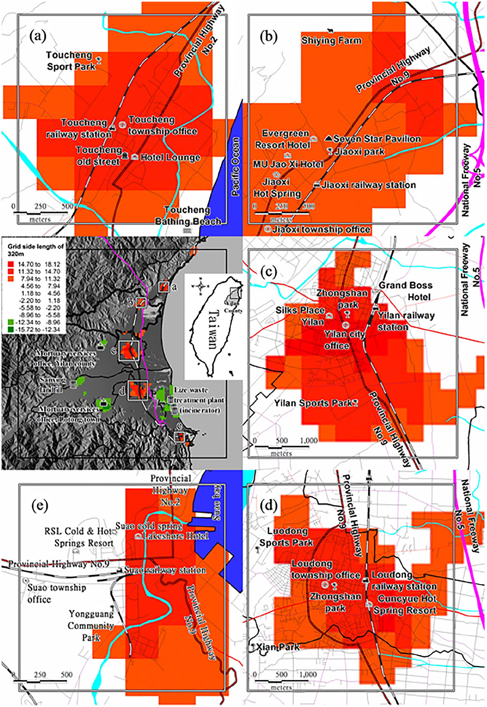
Distribution map of the optimal (orange-red) and the undesirable tourism facility locations (green) in Yilan Plain, Yilan County. The solid black-and-white line denotes the North-link line and the solid purple line denotes the National Freeway No. 5. Figure 5 illustrates that the four larger undesirable tourism facility locations in Yilan Plain (light green to green locations) are mainly related to the funeral parlor (funeral management office) and waste treatment (incinerator). By contrast, the five optimal tourism facility locations (orange to red locations) are near the government office in Toucheng Township (a), between Jiaoxi Hot Spring and National Freeway No. 5 (b), near the government office in Yilan City (c), Luodong Station (d), and Su’ao Station and Su’ao Bay (e).
Figure 5 indicates that many popular scenic spots or tourism facilities in Yilan County such as Toucheng Sports Park (Figure 5a), Shiying Farm (Figure 5b), Yilan Sports Park (Figure 5c), Luodong Sports Park (Figure 5d), and Yongguang Community Park (Figure 5e) are all located near the optimal tourism facility locations. In addition, well-known four- to five-star hotels in Yilan County such as Evergreen Resort Hotel and Mu Jiao Xi Hotel are located in the optimal facility locations in Jiaoxi Hot Spring (Figure 5b); Yilan The Walden, Grand Boss Hotel, and Silks Place Yilan are located near the optimal tourism facility locations in Yilan City (Figure 5c); Cuncyue Hot Spring Resort is located at the optimal tourism facility location in Luodong Station, (Figure 5d); the Cold & Hot Springs Resort Suao and Lakeshore Hotel are located in the optimal tourism facility locations in Su’ao Bay (Figure 5e); and the new business hotel—Hotel Lounge (Hotel Lounge, 2022), has started operations in 2020, is located in the optimal tourism facility location in Toucheng (Figure 5a). The analysis results indicated that the hotel industry formed the core location indicator of tourism facilities in Yilan Plain (B. C. Chen, 2002). Moreover, the five optimal tourism facility locations can generally be connected by the North-link line (Figure 5). In addition to Toucheng Township and Su’ao Bay, the effect of National Freeway No. 5 encouraged the shifting of or expansion of Jiaoxi Hot Springs, Yilan City, and Luodong Station toward (Figure 5b) National Freeway No. 5 (Figure 5c and d).
Utilizing GIS as a Visual Display Platform for Spatial Location Analysis Results
Geospatial analysis has developed into an essential analytical technique in many fields that require integrated analysis of spatially distributed geographic information (Zhu et al., 2021). And typically, the GIS software which is designed to store, retrieve, analyze, visualize, and share geographic information is involved to integrate the analysis of geospatial data (geo-computing; Maguire, 1991). In this study, before geospatial analysis can be carried out as shown in Figures 3 and 4, the relevant geospatial data were brought together (from Table 2 to Figure 2) in compliance with the processes in the “Research Methods” section and stored in Mapinfo Professional software (Precisely MapInfo Pro, 2022; Zhu et al., 2021). Therefore, Mapinfo GIS was applied to be the main visual display platform (Vasiutynska et al., 2018) for spatial location analysis results through topographic (Figure 1) and theme maps (Figures 2–5).
Conclusion
Practical Implications and the Limitation of the Analysis Results
This study builds up a procedure of MCE for the optimal facility location analysis of the tourism industry. The procedure take regional public facility that affect the land resource utilization on Taiwan’s alluvial plain region as factors and utilizes GIS technologies of buffering and weighted overlay analysis as spatial analysis tools (Figure 6). And given that the previously established regional public facility indicators and the test area in this study were all located in land regions of the alluvial plains, therefore, the practical implications of the analysis results could be interpreted limitedly within the alluvial plain excluding regions of coastlines, rock shores, hills, and mountains.

Procedure of MCE for the optimal facility location analysis of the tourism industry on Taiwan’s alluvial plain region. Radius of neighborhood, buffering, expert questionnaire, weights, and overlay analysis please refer to the “Research Methods” section.
This new analysis model combining “Push-Pull Location Decision,” “Location Set Covering Problem, LSCP” and “GIS Multi-criteria Spatial Analysis” is quite different from the related previous studies such as B. C. Zhang and Lin (2007) and Yao (2011) in terms of theoretical discussion and practical operation. And after testing this model on the Lanyang Plain where the only plain-type hot spring, the Jiaoxi Hot Spring, is located within it, we also found that by selecting appropriate spatial scales (grid side length), GIS tools can be used to perform multi-criteria spatial analysis quite efficiently. In addition, we also believe that the optimal facility location information of tourism industry concluded by this study can not only reflect the current distribution of tourism industry facilities, but also can attract more related industries to consider to plan their new projects near the optimal facility location. Therefore, we have confidence in that the optimal location analysis model of the tourism industry’s facilities based on regional public facilities and its related results are quite suitable for the land use or site/location selection of tourism-related industrial facilities.
Possible Social Implications
There is people’s livelihood first and then tourism (Chuang & Tseng, 2014). However, with the rapid development of the tourism industry, the regional public facilities that originally served mainly the local residents have now developed to be the indices of serving the foreign tourists and of indicating the optimal facilities location of the tourism industry including tourist hotels, theme parks, etc. Furthermore, in the classification of tourism/recreation resources in Taiwan (H.-K. Wang et al., 1993), besides the natural resources (e.g., topographic or geological scenic) and human resources (e.g., historical monuments) which have their original immovable geographic locations, industrial resources (e.g., leisure farms), amusement resources (e.g., theme parks), and related tourism service resources (e.g., tourist hotels) are more or less flexible in location selection. Therefore, we conclude that site/location selection with appropriate connection of regional public facilities can enable the sustainable development of tourism industry facilities and activities. And sustainable tourism industry facilities and activities can directly or indirectly promote the improvement of regional public facilities, which can be described as complementary to each other (Andereck & Nyaupane, 2011; García et al., 2015).
Footnotes
Declaration of Conflicting Interests
The author(s) declared no potential conflicts of interest with respect to the research, authorship, and/or publication of this article.
Funding
The author(s) received no financial support for the research, authorship, and/or publication of this article.