
Abstract
In times of climate change, it is said that the marginal population shall be the most adversely affected. This article attempts to explore the state of slums in Dehradun city and their susceptibility to climate change events, especially urban flooding. Taking the case of the state capital, we attempt to identify and demonstrate how the slum population is vulnerable to climate change events in the present and the future. Following risk-hazard approach, this article identifies and distinguishes vulnerable slums, per their sensitivity toward climate-led events using geographic information system (GIS) spatial analysis. Climate change trends show increasing precipitation and temperature trends, which is in agreement with current events of such phenomena in the city. Through GIS, the slums were mapped and their proximity to streams and roads were taken into account to generate vulnerable hotspots with respect to numbers, population, and location. The article then inquires into the inclusion of such vulnerable slums in various relevant state- and national-level policies discussing challenges and issues in implementation. The article finally derives the possibilities for inclusion of such marginalized classes through ongoing Government of India missions.
Introduction
Urbanization and climate change are the two most significant phenomena of the 21st century (Keivani, 2010; Stephenson, Newman, & Mayhew, 2010; While & Whitehead, 2013). Today, more than half of the world’s population live in urban areas (United Nations, Department of Economic and Social Affairs, 2014), of which 31.2% live in slums with 43% in developing countries (Un-Habitat, 2003). These proportions are set to increase with future urbanization and economic growth. In India, of 30% of the urban population approximately 17% live in slums; the proportion has doubled in the past 10 years from 43 million in 2001 to 93 million in 2011, with a projected growth rate of 5% (Census of India, 2011). Being a billion populated country, the number of slum dwellers is staggering in comparison with its percentage. Uttarakhand, the western Himalayan state, too has seen rapid urbanization, and since its inception as a state in 2000, its low-land planar regions have been attracting large hill population from higher reaches. This has led to an increased growth of slums in lowland cities such as Dehradun, Haridwar, Kashipur, and Rudrapur. These cities house almost 69.1% of the total 0.77 million population residing in 578 slums spread across the state (Pant, 2017).
There is a growing global concern for slums and their vulnerability to climate change. According to the World Bank Megacity Report, 2010 (World Bank, Asian Development Bank, & Japan International Cooperation Agency, 2010), climate change factors include an increase in the intensity of rainfall, sea level rise, and an increase in storm surge caused by climate change effects. Particularly, the people in densely populated (Huq, Kovats, Reid, & Satterthwaite, 2007) and high-risk areas are the most vulnerable to climate change (Intergovernmental Panel on Climate Change [IPCC], 2007). The impacts are compounded in India because a significant proportion of city dwellers live in slums.
Slums/urban poor are said to be the most affected groups by climate change events such as heat waves and flash floods (IPCC, 2014; Jaiswal et al., 2013; Un-Habitat, 2003). This is mainly because of the fact that informal settlements are generally located in areas most exposed to the effects of global climate change, notably low-lying areas, steep slopes, and ravines (Feiden, 2011; Sarkar, 2017). This is coupled with a lack of adaptive capacity due to insufficient infrastructure (Alcayna-Stevens, 2015; Porio, 2011; Satterthwaite & Moser, 2008; Wekesa, Steyn, & Otieno, 2011), poor socioeconomic status, insecure land tenure rights, and improper dwelling units (Kumar, Dutta, & Jain, 2014; Pandey et al., 2018).
In this regard, it is imperative to first identify those slum settlements which are most vulnerable to climate extremities. Then based on their exposure to risk it is necessary to prioritize them and actively plan for their resilience through pro-poor policies, reforms, or program-based interventions, addressing present and future vulnerabilities. The article in this regard, through geographic information system (GIS) tools and spatial query–based techniques, attempts to identify, highlight, and prioritize vulnerable slum areas in Dehradun city while inquiring into the inclusivity of slums in government policies. Thus, the article is accordingly divided into sections where, first, climatic parameters are discussed, highlighting the changing patterns in temperature and rainfall, followed by spatial analysis of slums based on their population, location, and probable climate change impacts; finally, various government initiatives in slum rehabilitation and development are discussed.
Study Area and Method
About Dehradun
Dehradun, the interim capital of Uttarakhand State, lies in Doon Valley on the foothills of Shivalik Himalayan range in India. Raj-era heritage, picturesque landscape, milder climate, and a getaway to upper regions make Dehradun a constant bustling place and a tourist destination (Figure 1). It is also an important administrative and industrial city housing eminent educational and research institutions. Over the past few decades, the city has grown as commercial, educational, and industrial hub, leading to rapid urbanization and large in-migration from all walks of life.
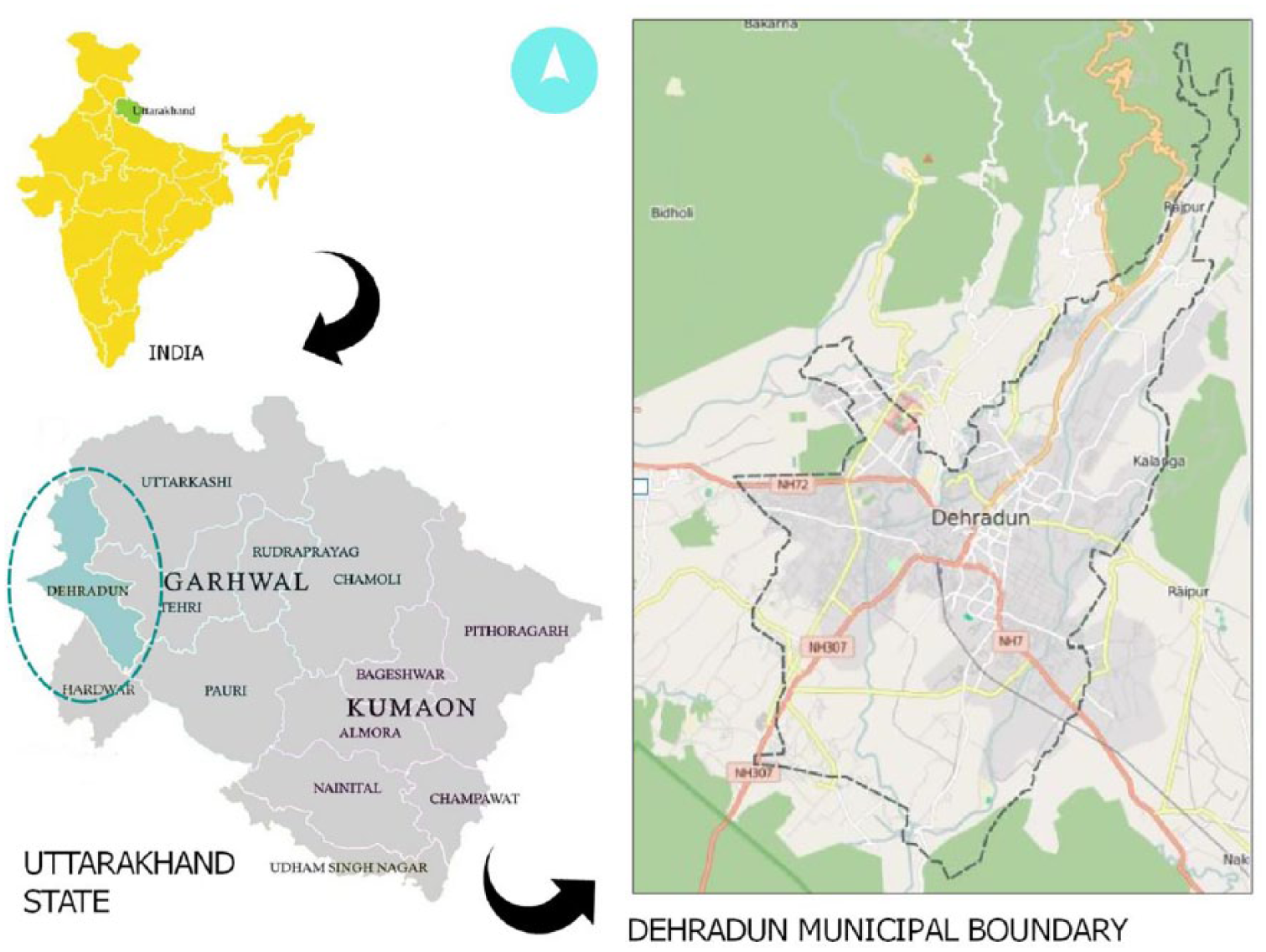
Location map of Dehradun city.
Geographically, the region is bounded by Himalayas on the north, Shivalik hills on the south, and Rivers Ganga and Yamuna on the east and west, respectively; its terrain consists of both plain and sub-montane tract, with elevations rising from planar south to skewed north. Two Perennial streams Bindal and Rispana also run through the city originating from mountain springs which were once used as natural source of water by the city inhabitants. Today these two streams are in dismal condition due to industrial affluent discharge, solid waste dumping, and slum encroachment along their banks (Dehradun City Development Plan, 2007).
Census of India 2011 reports the population of Dehradun City to be 569,578 under Dehradun Municipal Corporation. The population growth is well high above the national and state level with 27% compared with 18% and 17%, respectively. The city demonstrates a high literacy rate (88.36%) in comparison with Uttarakhand state (79.63%) and overall country (74.04%). The census report of 2011 also shows that the population growth in Dehradun urban agglomeration has almost doubled from 447,808 to 714,223 over a span of 10 years from 2001 to 2011. This can be attributed to the fact that the new industrial development policy of 2003 has led to the establishment of a number of medium- and small-scale industries around the city, which has caused high rural–urban migration (Deutsche Gesellschaft für Internationale Zusammenarbeit, 2011). This is a ground for concern because Doon Valley is an eco-sensitive zone with contribution of the Himalayan Mountain’s fragility and hydrological sensitivity (National Environmental Engineering Research Institute, 1989); hence, the city is geographically vulnerable to climate change events such as extreme precipitation, urban flooding, and cloud bursts (Gupta, Nair, & Yunus, 2013). The rising population and urbanization pose a serious threat to the eco-sensitivity of Doon Valley, making it highly susceptible to natural hazards.
Climate Trends
Dehradun experiences winter season from December to February, summer season from March to May, monsoon or south-west monsoon from June to September, and post-monsoon season from October to November (Sharma, Singh, & Saklani, 2012).
A study by O. Singh, Arya, and Chaudhary (2013) analyzed the temperature trends of Dehradun for a span of 41 years from the Indian Meteorological Department (IMD) data. As shown in Figure 2, it can be observed that the annual mean temperature exhibited a constant warming period since the year 2000. Linear trend analyses revealed that the annual mean temperature was increasing, being less pronounced in Phase 1 (1967-87) than in Phase 2 (1988-2007). From 1967 to 1987, a 20-year duration, the annual mean temperature changed only 25% (increase of 0.12°C), while in the next 20 years, from 1988 to 2007, it rose by 0.54°C, that is, 110% of total change in 41 years. The rise in temperature was attributed to a decrease in green cover and an increase in urbanization, as well as industrialization in the city which began majorly in the second phase. Although no further studies could be found since 2007, weather data which were referred from other secondary sources 1 for the period 2009-2015 point toward positive trend as well.

Annual mean temperature variations.
Study on precipitation by Sharma et al. (2012) based on IMD data reveals that Dehradun receives light to heavy precipitation throughout the year, with occasional very heavy rainfall (>12 cm) during the monsoon season, and they found that the rate of precipitation increased almost 38% over the last decade (Figure 3). Similar studies undertaken by Pranuthi, Dubey, Tripathi, and Chandniha (2014), R. B. Singh and Mal (2014), Pranuthi et al. (2014), and R. B. Singh and Mal (2014) detected accelerated change in climate patterns with decreasing rainfall trend during monsoon months while increasing post-monsoon season trend with a variability of 21%.
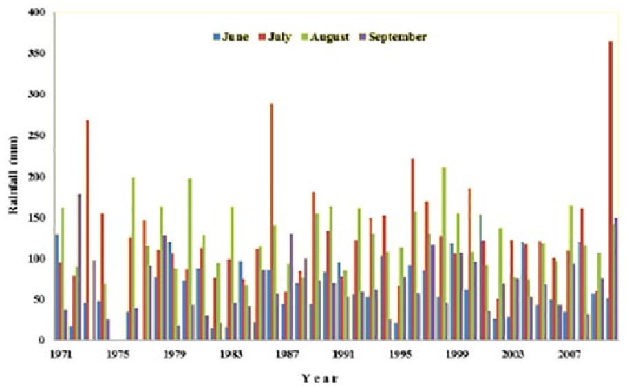
Precipitation trends.
Method
GIS was mainly used in the spatial analysis followed by review of government policies to assess representation of slums and their geographic vulnerabilities. Widely accepted risk-hazard approach (Füssel, 2007; Hjerpe & Wilk, 2010) was used because it provides magnitude of exposure units to hazards. The risk-hazard approach was used to map risk of heat. These heat maps indicated the administrative wards which are most sensitive to heat and need to be prioritized.
The study used data set from Dehradun Municipal Corporation, Census of India, 2011, which comprised slum locations, population, and number of households. This was followed by procurement of map from Survey of India which geo-referenced demarcating boundaries and administrative wards in GIS, thus creating a vector data model. The location of each slum was marked on the map, and their respective data sets were estimated using weighted method in GIS. Population was used as the weight because a larger population reflects greater exposure to risks (Huq et al., 2007; IPCC, 2007). Further studies (Chatterjee, 2010; O’Hare, Abbott, & Barke, 1998) suggest that slum dwellers located in low-lying areas of the city are most vulnerable to impact on urban flood events. Hence, streams Bindal and Rispana were marked on the map and buffer zones were created along the river to identify slums proximate to the flood plain zone of the streams. Finally, hotspots with higher levels of heat were generated using heat map technique in GIS to highlight vulnerable slums.
Analysis
Slums in the City
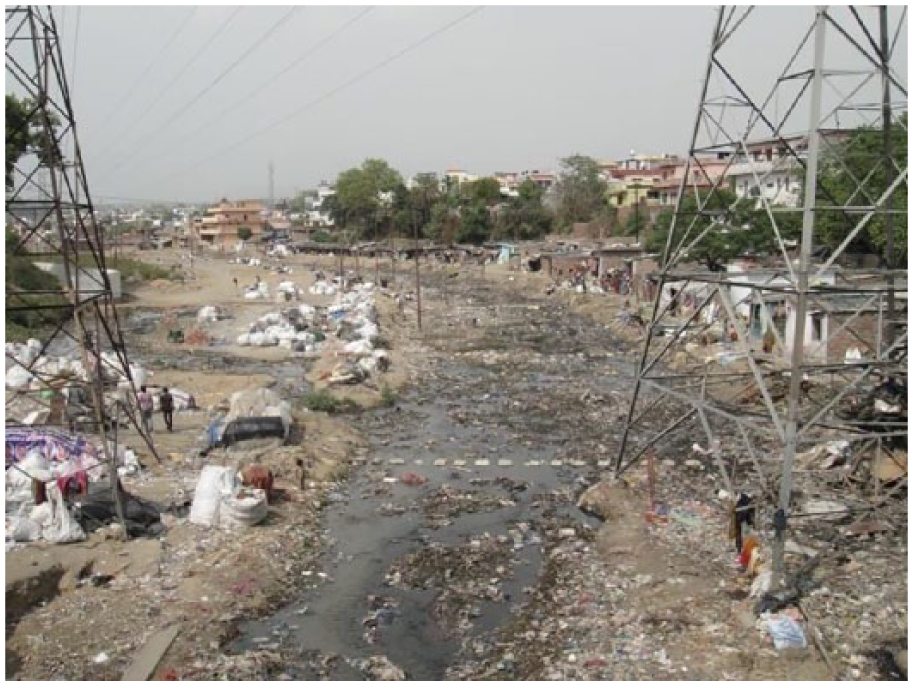
At present, there are about 128 slums with 0.16 million inhabitants covering an area of approximately 2.88 km2 out of the total 34.00 km2 in the city (Census of India, 2011). The population of the slums varies between 250 and 5,000 and is spread across various critical locations in the city. The average household size being 7.1, slums in Dehradun fare better tha other Indian cities in terms of housing and environmental sanitation (Dehradun City Development Plan, 2007), as well as literacy rate (82.92%) (Census of India, 2011). However, most of the slums are located on encroached land along the river banks of Bindal and Rispana and have poorer socioeconomic status in comparison with other slums (Figures 6 to 9). Figure 4 shows the population bubble map of slums and their locations. Analyzing the location of slums in GIS environment and their population (Figure 5), it is observed that the slums are located either in proximity to the main highways or along the floodplains of Bindal and Rispana rivers, the latter being the most populous case.

Ward-wise slum population bubble.

Slums proximate to streams (within 100 m of river buffer).
Bindal river.

Rispana river.

Slums at Indira Colony Ward 14.

Slums at Dalanwala (East) Ward 26.
Climate Change Impact and Analysis
As the population continues to grow, more impact on the land and its resources was foreseen by the 4 × 4 Assessment Report by Ministry of Environment and Forest, Government of India (Indian Network on Climate Change Assessment, 2010) on climate change assessment. It indicates that the mean annual temperature in Himalayan regions is estimated to increase from 0.9 ± 0.6°C to 2.6 ± 0.7°C in 2030s. It also states that the net increase in temperature will range from 1.7°C to 2.2°C compared with the 1970s, showing a rise in temperatures in all the seasons. However, it indicates a decline in winter temperatures in the months of October, November, and December by 2.6°C in 2030s compared with the 1970s. With respect to precipitation, the 4 × 4 Assessment Report predicts an increase in the number of rainy days by 5 to 10 days on an average in 2030s, with the intensity of rainfall increasing by 1 to 2 mm/day. The study also indicates an increase in annual rainfall from 5% to 13% in 2030s in contrast to the 1970s. The PRECIS simulations run for the study shows that the annual rainfall in the Himalayan region may vary between 1,268 ± 225.2 mm and 1,604 ± 175.2 mm.
These predictions are in alignment with Dehradun as well; from the changes in climatic parameters (rainfall and temperature), it can be inferred that the exposure of marginal populations such as slums is likely to increase (Huq et al., 2007; IPCC, 2007). These changes may lead to problems of waterlogging due to inadequate development planning, such as drainage and highly impervious land stretch of the city leading to urban flooding. High precipitation exposes the most populous slums which are proximate to streams to risk of loss of life, shelter, health, and livelihood (Chatterjee, 2010; O’Hare et al., 1998). Furthermore, an increase in rainy days by 5 to 10 days has a detrimental effect on the livelihoods of daily wage earners. Bansal, Mukherjee, and Gairola (2015) reported that the incidences of urban flooding have increased over a period of time because of increased rainfall run-off volume. This has led to increase in damages due to these events, exposing the populace to higher risks. Other related impacts of climate change extremities with respect to present issues are elaborated in Table 1, which shows how the present issues of unregulated urban growth and encroachments shall lead to increased risks of exposure and health hazards.
Present Issues and Future Impacts (Habeeb, 2016).

In Uttarakhand Action Plan on Climate Change (2014 UAPCC; Government of Uttarakhand, 2014), vulnerability of slums to climate change is addressed to identify and assess all slums and ensure that all unauthorized encroachments are removed/dealt with appropriately. Growing formal and informal settlements in the city demand more infrastructure services that are both social and physical. It is thus requisite for the urban local bodies and development authorities to plan in accordance with the demographic trends of population growth, settlement pattern, and socioeconomic strata.
This study is relevant for addressing the concern of identifying and assessing the slums in Uttarakhand which are vulnerable to climate change impacts stated in the UAPCC (Government of Uttarakhand, 2014). There are growing formal and informal (unauthorized) settlements in the city which demand more social and physical infrastructure services. This necessitates the urban local bodies and development authorities to plan in accordance with the vulnerability to climate change, demographic trends of population growth, settlement patters, and socioeconomic strata. Vulnerability of slums was identified by creating a river buffer of 100 m along streams Bindal and Rispana (as per National Green Tribunal Norms wherein no settlement or construction is allowed in 200-m proximity to river bodies; Figure 5). In the analysis phase, slums in Wards 10, 13, 21, 22, 26, and 57 show a high sensitivity of exposure to urban flooding and extreme precipitation events. The analysis (Figure 10) also indicates high-risk levels for major slum settlements as these are most populous slums located within 100-m buffer of streams.
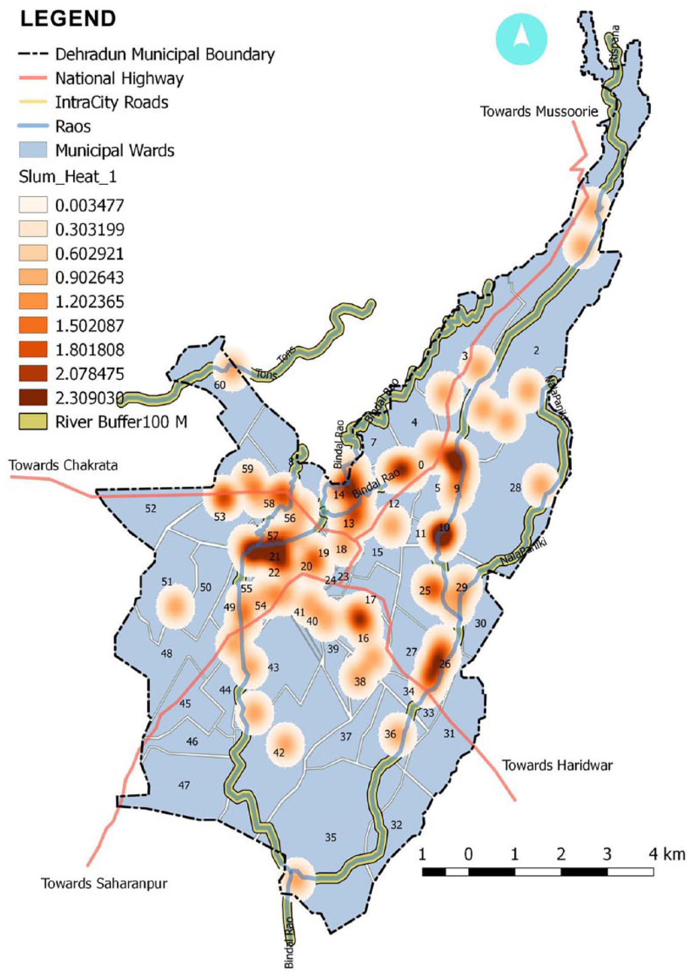
Vulnerable slum hotspots.
The “Uttarakhand Regularization, Rehabilitation, Resettlement and Prevention of Encroachment of the Slums Located in Urban Local Bodies of the State Rules 2016” classifies slums into different categories based on their location and land ownership According to the analysis, as many as 47 of the 128 slums in Dehradun fall under Class 3 category (geological/geographical/environmental-sensitive zones where it is not possible to award land ownership due to legal/practical, human habitat, health, and safety reasons). It also shows that slums located in this category (Wards 10, 14, 21, 22, 26, 57) are highly populated (approximately 57,776, more than one third of the total slum population). They will need resettlement as they are dangerously close to streams and face natural and health hazards due to urban flooding.
Discussion
Since the last two decades, many national policies have evolved to cater to slums in India, namely, National Slum Development Program (NSDP, 1996), Valmiki Ambedkar Awas Yojana (VAMBAY, 2001), Integrated Housing & Slum Development Program (IHSDP, 2005), and Basic Services to the Urban Poor (BSUP, 2005) under Jawaharlal Nehru National Urban Renewal Mission (JNNURM), Rajiv Awas Yojana (RAY, 2009), and Pradhan Mantri Awas Yojana Housing For All (PMAY-HFA, 2015). These programs marked the paradigm shift to a more optimistic perspective regarding issues of slums, realizing their right to basic amenities and livelihood in the city (Sawhney, 2013).
Broadly, these policies attempted to provide housing to slums mainly focusing on relocation and rehabilitation until 2001. The emphasis of new policies launched since 2005 was on provision of necessary infrastructure in situ and legal land ownership rights (Hindman et al., 2015; Steering Committee on Urbanization, 2011). However, most of these plans were underimplemented due to several reasons: first, due to the time-consuming nature of planning for slum surveys, identification, and prioritization (Ministry of Housing and Urban Poverty Alleviation, Government of India, 2012); second, lack of sufficient funds to meet the requirements (Mohamed, 2017); third, tedious process for award of land ownership and land tenure rights (Mohamed, 2017; Smitha & Francis, 2015); fourth, nonavailability of private developers in execution of housing projects due to very low profit margins (Hindman et al., 2015; Steering Committee on Urbanization, 2011); and fifth, resistance from slum dwellers to relocation due to fear of loss of livelihood opportunities (Hindman et al., 2015; Ministry of Housing and Urban Poverty Alleviation, 2012; Mohamed, 2017) and reluctance to be formally included in the administrative framework of the city as it might attract levy of taxes and charges from authorities (Steering Committee on Urbanization, 2011).
All these factors have led to very slow inclusion process of slums in the planning process; the most recently launched PMAY-HFA, 2015, attempts to provide housing for all sections of the society, including slums and urban poor in its In Situ Slum Rehabilitation (ISSR) and Affordable Housing in Partnership (AHP) component, respectively. ISSR mainly focuses on slums with land ownership rights; AHP aims at providing dwelling units to urban poor, including those slums without land ownership rights in which tenants need to contribute financially. Although the mission accounts for in situ slums, it is subject to land ownership rights and it has been observed that both slum dwellers and private developers desist in undertaking ISSR due to the above-stated reasons. However, the most vulnerable slums are on illegally developed land, proximate to river beds, low-lying plains, and other such areas with nontenability. While a secured land tenure continues to be the main criteria for any government mission, award of land tenure rights needs to be based on the susceptibility of the slums due to urban flooding and extreme precipitation events. It is critical to include rehabilitation agenda based on the vulnerability of slums in the mission considering socioeconomic implications as well as cost–benefit analysis of the projects seeking availability of land with land tenure rights from municipal body itself, especially nazool land or land which is yet to be claimed by the municipal body.
In Uttarakhand, new policies have been devised to address slums and climate change through Uttarakhand Slum Regularization and Rehabilitation Act (Slum Act, 2016), wherein slums were categorized based on their location and land ownership and tenability. However, if the current statistics are to be evaluated, slum improvement was to be taken as one of the initiatives under the scope of Uttarakhand Urban Sector Development Investment Program (UUSDIP; 2016) apart from other infrastructure developments. The projects on infrastructure took better shape in comparison with those based on slum improvement and development (http://uusdip.org/, UUSDIP, 2016). Also, the City Development Plan (CDP) for Dehradun was prepared in 2007 under JNNURM, which devised city investment plan, strategies, and implementation plan for urban poor, mainly slums, to convene immediate housing need, providing proper sewerage and drainage facilities in identified slums and also rehabilitating and resettling slum settlements along the river banks exposed to extreme climate events such as flooding. Unfortunately 10 years after CDP, only 150 houses could be built for rehabilitation of slum dwellers (Jha, 2018). With formulation of Slum Act, 2016, the state government plans to take most vulnerable slums in the second phase of slum development program after ISSR is taken first (Pant, 2017). But the main question that looms is how long will it take for the marginalized to find their foothold in the mainstream.
Conclusion
This article highlighted two major issues in dealing with slums: first, what are the most vulnerable slums with respect to climate change events such as urban flooding and extreme precipitation; second, how are they being addressed through government policies. Both present and future impacts of climate change extremities can be seen on the marginal population. Although attempts have been made at both state and national level, still, there is a gap in addressing the most vulnerable slums. The question of inclusivity of slums often borders at the ownership of land, and for those without one, rehabilitation continues to be a challenge for acceptability among slum dwellers. Multicriteria-based GIS evaluation method can be a probable answer for identification and assessment of slums, thus aiding in their prioritization for development and bringing a consensus between planning and policies. While the world braces for changing climate work toward inclusivity of all the classes, addressal of most vulnerable groups is the need of the hour. On January 2016, under Agenda for Sustainable Development of 2030 as adopted in 2015 United Nations Summit by world leaders, 17 Sustainable Development Goals (SDGs) were enforced. These goals encompassed leveraging efforts to eliminate poverty, fight inequalities, deal with climate change, and ensure to include each section of society at all times. Efforts have been made to understand and predict probable climate-led events; however, there is a long road toward inclusion and addressal of marginal in the great climate change debate.
Footnotes
Declaration of Conflicting Interests
The author(s) declared no potential conflicts of interest with respect to the research, authorship, and/or publication of this article.
Funding
The author(s) received no financial support for the research, authorship, and/or publication of this article.