
Abstract
Public open spaces are essential for residents’ social interactions and recreational activities, improving well-being as well as offering economic and environmental benefits. Saudi Arabia is aiming to enhance the quality of life in all its cities through different national programs and projects. One of the key performance indicators is increasing public open space per capita from 3.47 to 3.9 m2 by 2020. This study measured the current public open space per inhabitant in Jeddah using a geographic information system (GIS) to identify the types of public open spaces that make up the per capita value in the city. Jeddah is located in a rapidly developing country, and it is a replanned city where the current status of public open spaces falls short of users’ expectations and does not meet international standards. This study suggests that the Ministry of Municipal and Rural Affairs and municipalities should adopt a systematic approach to tackling the spatial distribution of open spaces in Saudi cities. In addition, there is a need for the proactive involvement of planners, landscape architects, and designers in the planning process.
Highlights
Introduction
This study aims to fill a gap in the literature concerning the current practice of public open space planning and identifying the spatial planning and management policies of outdoor spaces.
The findings reveal that the public open spaces are only designed by nonspecialists and without the involvement of planners, landscape architecture, and expert with knowledge. This is having a major negative effect on the quality of life and the spaces provided by the municipalities for city residents, especially the safety of the users.
The article argues that, if the Saudi Arabia’s vision is to enhance the quality of life and increase the public open spaces per capita, there is a need for a multidimensional and proactive open space planning and design which must be reconsidered and enhanced according to the international standards to meet the needs and desires of city residents without affecting their safety and to provide them with spaces that meet their needs.
The topic of public open spaces in cities has become very important globally in terms of their provision and the benefits they offer to both the cities themselves and individuals. These spaces are considered as fundamental to cities because of the physical, mental, and social benefits they offer (Burgess et al., 1988; Olwig, 2016). Public open spaces can also provide cities with environmental benefits, such as reducing the effect of urban heat islands (Dimoudi & Nikolopoulou, 2003; Norton et al., 2015).
For residents, public open spaces are important in enhancing and promoting physical activities by encouraging people to walk and exercise (Hillsdon et al., 2006; Koohsari et al., 2015). Furthermore, studies have shown that these spaces can improve users’ mental well-being (Curtis, 2010; Wood et al., 2017). Public open spaces also contribute to social cohesion (Yung et al., 2016) and bring people from different ethnic backgrounds together (Addas & Rishbeth, 2018).
The World Health Organization (WHO) and the United Nations have identified the minimum per capita public open space in urban areas for healthy living and enhancing the quality of life of residents. These are considered as common standards and are widely used in the study of open spaces to examine whether a city is achieving adequate provision of public open spaces (Senanayake et al., 2013; Shahfahad et al., 2019).
In Saudi Arabia, various programs and initiatives are underway to enhance the quality of life in cities as part of the country’s Vision 2030. The Quality of Life Program (QLP) was launched in 2018 as one of the government’s 12 Vision 2030 initiatives under the National Transformation Program (NTP). The QLP aims to improve the quality of life by providing a supportive environment that is designed to enhance the lives of all citizens, facilitating their participation in various cultural, recreational, and sporting activities (Addas, 2018).
One of the NTP key performance indicators (KPIs) is to increase public open space per capita in Saudi cities from 3.47 to 3.9 m2 by 2020. This is a challenging target because of current practices of planning and urban design at the city level, as highlighted in a number of studies (Abubakar & Aina, 2018; Al-Hathloul & Mughal, 2004; Atef Elhamy Kamel, 2013; Mandeli, 2008). Furthermore, consideration of the benefits and values of public open spaces have been neglected in Saudi cities until recently.
Mandeli (2011) noted that the demands of the modern economy in Saudi Arabia and planning processes that were designed to reshape society have resulted in a sharp break from the traditional urban environment. In recent decades, economic activities have been centralized in large cities, such as Jeddah, and the Saudi economic system has been integrated with Western economies.
It was believed that the health of the economy could be maintained only by changing the nature of the built environment. Large-scale housing and transportation projects were initiated, redeveloping old cities and creating new residential areas and road networks (Alharbi, 1989; Al-Nowaiser, 1982). These changes have been driven by land-use regulations put in place by central and local authorities prioritizing physical uniformity and economic productivity (Mandeli, 2011). These regulations have also focused on vehicle use which, together with the segregation of people according to their economic and social status, has led to the physical decomposition of the urban fabric and social disintegration (Akbar, 1981; Bokhari, 1978).
This prioritization and the development strategies that were employed, including the creation of single-use areas, have had damaging effects on urban public open spaces in cities across the Middle East; Sidky and Bastawisi (2010) described cities in Egypt as urban environments that demonstrably lack balance. The same could be said of cities such as Jeddah in Saudi Arabia, where outdoor spaces are widely dispersed and barely accessible and fail to provide protection from very hot weather. The absence of suitable public open spaces has undermined any sense of community or identity and discouraged people from taking part in social experiences and physical activities (Al-Hathloul & Mughal, 1999; Eben-Saleh, 2002; Mandeli, 2011).
These issues have arisen because the design and planning of public open spaces have been approached somewhat haphazardly in most Saudi cities (Addas & Rishbeth, 2018; Mandeli, 2010). In Jeddah, after the demolition of the Jeddah Wall, five master plans were prepared for the city (Table 1). Each of these master plans considered the provision of public open spaces to some extent, but to different levels and in different areas.
Jeddah Master Plan From 1962 to 2004.

These five master plans did not achieve the successful provision of public open spaces because decision-makers focused on providing residential development and there was a lack of an overall strategy or framework for public open spaces. As a result, the outcome of the planning process is seen as meaningless. The public open spaces that do exist are often poorly used and are, in some cases, in locations that are dangerous to residents, with access across busy roads.
Although initiatives such as the QLP seek to increase public open space availability quantitatively, there is no clear understanding of what should be considered as usable public open space, differentiated from other visual amenity spaces. Given the benefits of public open spaces and their role in encouraging linkages and a sense of pride and belonging (Addas, 2015), the aim should not simply be to achieve a numerical target; the value of the spaces and the way they connect the city are what is important (Timperio et al., 2007). Therefore, this study aims to calculate the actual usable public open spaces per capita in Jeddah.
This study will help highlight planning issues associated with public open spaces in the city. It will also show whether increasing the availability of public open spaces in Saudi cities would be dependent on the Ministry of Municipal and Rural Affairs (MoMRA) introducing design and planning approaches that enhance city planning.
Method
The methodology for this study included data collection to identify all gardens and public open spaces within the Jeddah municipality. All open spaces were then classified into one of 11 types according to their nature and location (Table 2). It is important to highlight that this study does not propose a typology for public open spaces in the city of Jeddah. However, the authors classified the current spaces in the city according to the geographical location, condition, and spatial arrangement of each site. However, such a typology should be created to assist the provision of public open spaces and provide a framework to guide the city’s decision-makers.
Open Space Category.

There are 19 districts in Jeddah, with a variety of land uses that include gardens. All public open spaces in these districts were drawn using a geographic information system (GIS). The creation of maps and a database depended on satellite images and the city strategic master plan. Car surveys were used to validate the situation and condition of public open spaces. Statistical analysis of each district was applied to generate the required graphs, maps, and tables. The population of each district was obtained from the General Authority for Statistics and Jeddah Urban Observatory (JUO); the methods used to calculate the public open spaces per capita by JUO are presented in the findings of this study to highlight the differences.
After producing the graphs and maps, the authors reviewed public open spaces against population data and identified the types of public space using four scenarios to present the findings. For Jeddah, the results of public open spaces per capita were compared with international standards produced by the WHO, the Public Health Bureau USA, the European Union, and the United Nations. In addition, the findings are compared with MoMRA guidelines and JUO findings. In addition, particular types of space were highlighted to identify current planning practices in the city, namely, garden unbuilt (T2), roundabout (traffic circle) (T5), walkway central median (T8), garden central median (T9), and cloverleaf space (T11). Changes in land use from garden to residential are also highlighted.
Findings
The population data were obtained from the JUO (2016) report. In 2015, Jeddah had 4,060,591 inhabitants, which equated to 12.8% of the total population of the kingdom. The average annual growth in the population was 3.2%. Of the 19 districts, not all are fully occupied or built; Figure 1 shows the occupied and underdeveloped districts and their populations.

Occupied and underdeveloped municipalities.
Figure 2 shows the percentage of the open space types which were generated using the GIS data. The proposed public open spaces make up 62% of the total area of the spaces in Jeddah. If all these sites were implemented effectively, the city would have a good public open space system, as shown in Scenarios 3 and 4; it is important to note that these spaces must be of good quality to meet users’ needs and demands (Addas, 2015).

Percentage of each open space according to the study category.
Existing gardens and the land that is supposed to be used for gardens equate to 4% of the total public open spaces in the city. Unbuilt gardens comprise 24% of the total and indicate that governments do not have enough financial or operational resources to build these spaces.
Scenarios
The findings regarding the city are presented through four scenarios discussing the analysis according to the public space types that were identified. Each scenario investigates the data and the open space classification according to different suggestions as to what should be included in the per capita value for the city. The public open space per capita was calculated in a different way in each scenario. The following equation was used:
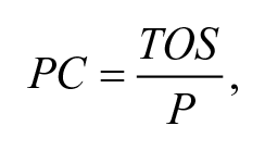
where PC is the per capita, TOS is the total area of spaces, and P is the population.
The first two scenarios examine the current and existing situations of public open spaces. The third and fourth scenarios look at the future situation taking account of the unbuilt and proposed public open spaces. The results of two of the scenarios are compared with the JUO data, which indicated that the figure for public open spaces per capita was 7.54 m2 in 2014 (JUO, 2016).
Scenario 1
The first scenario looks at T1 public open spaces according to the above classification. This type is for all gardens that are located in neighborhoods, or at the district and the city level. All other spaces, such as the waterfront, are excluded from this scenario. We argue that the per capita calculation should be based on spaces that residents pass by daily and not include those spaces they spend time traveling to visit (Chiesura, 2004; La Rosa, 2014). The relevant public open spaces are those that surround offices or houses and places where residents go for shopping or business. Jeddah has in total 2,050,493 m2 of public open spaces (T1) distributed in all 19 districts with a total of 432 public open spaces (Figure 3). This means that there is one garden for every 8,949 inhabitants.

Distribution of gardens (T1).
By applying the equation, we find that public open space equates to 0.5 m2 per capita. This figure is well below international standards, as shown in Table 3. To meet the minimum standard of the WHO, there is a need to plan and design a total area of 34,494,880 m2. A total area of 119,767,291 m2 would be required to meet the United Nations’ standard.
International Standards and Scenario 1.

Note. POS = public open spaces.
Scenario 2
In this scenario, the waterfront side (T10) in Jeddah is added to the first scenario as well as plazas (T4), of which there are few in the city. The reason for including the waterfront is because it is considered as the main recreational destination in the city for residents and visitors. When adding the total area of the waterfront spaces (T10) in Jeddah and the plazas (T4) to the total from the first scenario, the sum is 3,870,028 m2 of public open spaces (Figure 4).

Distribution of gardens, waterfronts, and plazas.
We find that the total area of the public open spaces (T1, T4, and T10) equates to 0.95 m2 per capita. This result is still far from international norms of public open space per inhabitant. Comparing the result with the WHO minimum indicates that Jeddah municipality needs to increase the total area of public open spaces (gardens, plazas, and waterfront spots) by 89.40%. Furthermore, to meet the United Nations’ 30 m2/capita, there is a need for an additional 117,947,702 m2 of public open spaces (Table 4).
International Standards and Scenario 2.

Note. POS = public open spaces.
Scenario 3
This scenario presents the future and the proposed total area of public open spaces according to data from the municipality of Jeddah and adds Types T2 (garden unbuilt) and T3 (garden proposed) to the results of the previous analyses. This analysis helps us estimate the future area of the public open space network in Jeddah if all the proposed and unbuilt spaces were implemented.
The total area of the unbuilt open spaces which are located in residential areas across the city is 11,033,829 m2. In addition, the total number of the proposed public open spaces which will be built in neighborhoods is 29,281,770 m2 (Figure 5).

Distribution of gardens, unbuilt, proposed, waterfront, and plazas.
By adding the total area of T2 and T3 to the previous scenario totals, it can be seen that Jeddah will have a total area of public open spaces of 44,185,627 m2 (Table 4). This will increase the public open spaces per capita from 0.5 m2 in Scenario 1 and 0.95 m2 in Scenario 2 to 10.88 m2. However, in this scenario, we must keep in mind that the implementation of these spaces will take time and the population of the city will also increase. It is important to note that the total area of the unplanned open spaces in fully occupied neighborhoods is 11,033,829 m2. This is almost five times the current total area of public open spaces and reflects a lack of understanding of the importance of public open spaces as well as a lack of resources in the municipality, such as funds and staff capacity and knowledge, focused on the planning and design of public open spaces.
Scenario 4
The authors argue that the T8 (walkway central median) and T9 (garden central median) spaces have not been planned or designed by city planners or specialists and so should not be included in the analysis. These spaces are the walkways and public spaces in the central medians of streets. According to international standards, there are guidelines that could be applied to ensure that these spaces do not affect users’ safety. By adding the areas of T8 and T9, the open space per capita in Jeddah is 11.17 m2 (Figure 6).
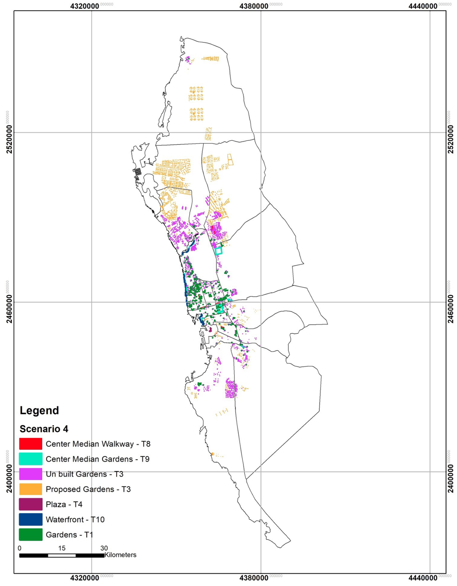
Distribution including T8 and T9 spaces.
This result is similar to the third scenario and will also be affected by the population increase in the city by the time of the implementation of these spaces. The shortage of the overall area needed is less than that in the first two scenarios (Table 5).
International Standards and Scenario 3.

Note. POS = public open spaces.
Change of Land Use
The analysis of the GIS data showed that there is a current practice in Jeddah by which land use is different compared with the approved master plan. Change of use amounts to a loss of 1,591,366 m2 that is supposed to be built as gardens (Figure 7). These areas have been changed to residential, governmental, or religious land use. The investigation showed that the loss of this land has not been compensated for in other areas. New Jeddah district has seen the greatest loss, totaling 390,094 m2. This loss reflects the construction of many new buildings in the district, with an evident lack of gardens and parks (Figure 8). However, the district also has 187,163 m2 of unbuilt public open spaces, which equates to about 55 gardens. Another example is the Alnassem district, which has 11 approved open spaces but, currently, has only one public open space (Figure 9).

Land use changed.

New Jeddah district.

Alnassem district.
Public Open Spaces in Planned Districts
This section explores the structure of the fully occupied districts in Jeddah in terms of the open spaces per capita to help identify which meet international standards according to the previous scenarios (Table 6). It is clear from the table that the majority of these districts do not meet the international standards and all of them have a shortfall in public open spaces except New Jeddah, which could be close to the WHO standard under the third scenario.
International Standards and Scenario 4.

Note. POS = public open spaces.
Public Open Space Catchment Area
The accessibility of public open spaces is very important (Fan et al., 2017) and there are available standards. An analysis against these standards can provide an effective indication of the spatial planning of public open spaces in the city. According to the Accessible Natural Greenspace Standards Model, English Nature (EN) recommends 300 m as a walking distance to a public open space (Harrison et al., 1995). Furthermore, the European Environment Agency recommends a maximum distance of 1,000 m (Giles-Corti et al., 2005). MoMRA recommends a maximum of 800 m, which is the transition point from walking to driving based on the MoMRA’s standards.
The accessibility analysis shows that the spatial distribution of public open spaces in Jeddah does not reflect the location of these spaces and the various levels of accessibility. The accessibility assessment was carried out for 800 and 300 m distances for the four scenarios using buffer tools in the GIS.
The results show that the city performs poorly regarding the catchment areas in Scenarios 1 and 2 (Figure 10a and 10b). The lack of strategy for allocating public open space creates gaps in the city and poor accessibility. The findings reveal that the open spaces in the city are not located within suitable walking or driving distance from users’ residences and workplaces. However, by applying the 300- and 800-m buffers to the third and fourth scenarios, it can be seen that the majority of the districts could have sufficient coverage of public open spaces when compared with the existing situation (Figure 10c and 10d). Table 7 shows the coverage percentages for 300- and 800-m buffers for the existing and proposed public open spaces in Jeddah.

(a) Scenario 1, (b) Scenario 2, (c) Scenario 3, and (d) Scenario 4.
Per Capita in the Fully Occupied Districts.

Overall, public open spaces comprise a very small area in terms of the land use of each district under each of the scenarios. The analysis of the collected data shows that, when applying Scenario 4, the public open space area will amount to 2.42% of the total area (Table 8); this is a very low figure given the area and population. In addition, the area of open spaces in 17 of the districts is below 1%, with the exceptions of Almattar and New Jeddah at 1.26 and 1.01, respectively. This is clear evidence of the lack of understanding of the importance of public open spaces, and the planning process does not consider these spaces as important land use by the city.
Coverage Percentages for Each Scenario.

Discussion
The review of the latest Jeddah master plan indicates that the city has sufficient proposed green structures in terms of gardens and parks (Figure 11a). However, the findings showed clearly a lack of understanding of the importance of the provision of public open spaces in Jeddah municipality (Figure 11b). Currently, the city is some way behind the NTP target (3.9 m2 per capita) which aims to enhance the quality of life in Saudi cities. In addition, there is a clear shortage of public open space areas in each district (Figure 12).
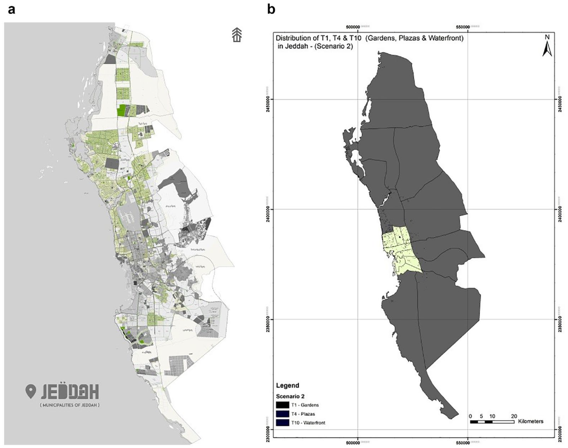
(a) Gardens and parks in Jeddah Municipality Master Plan and (b) current open space.
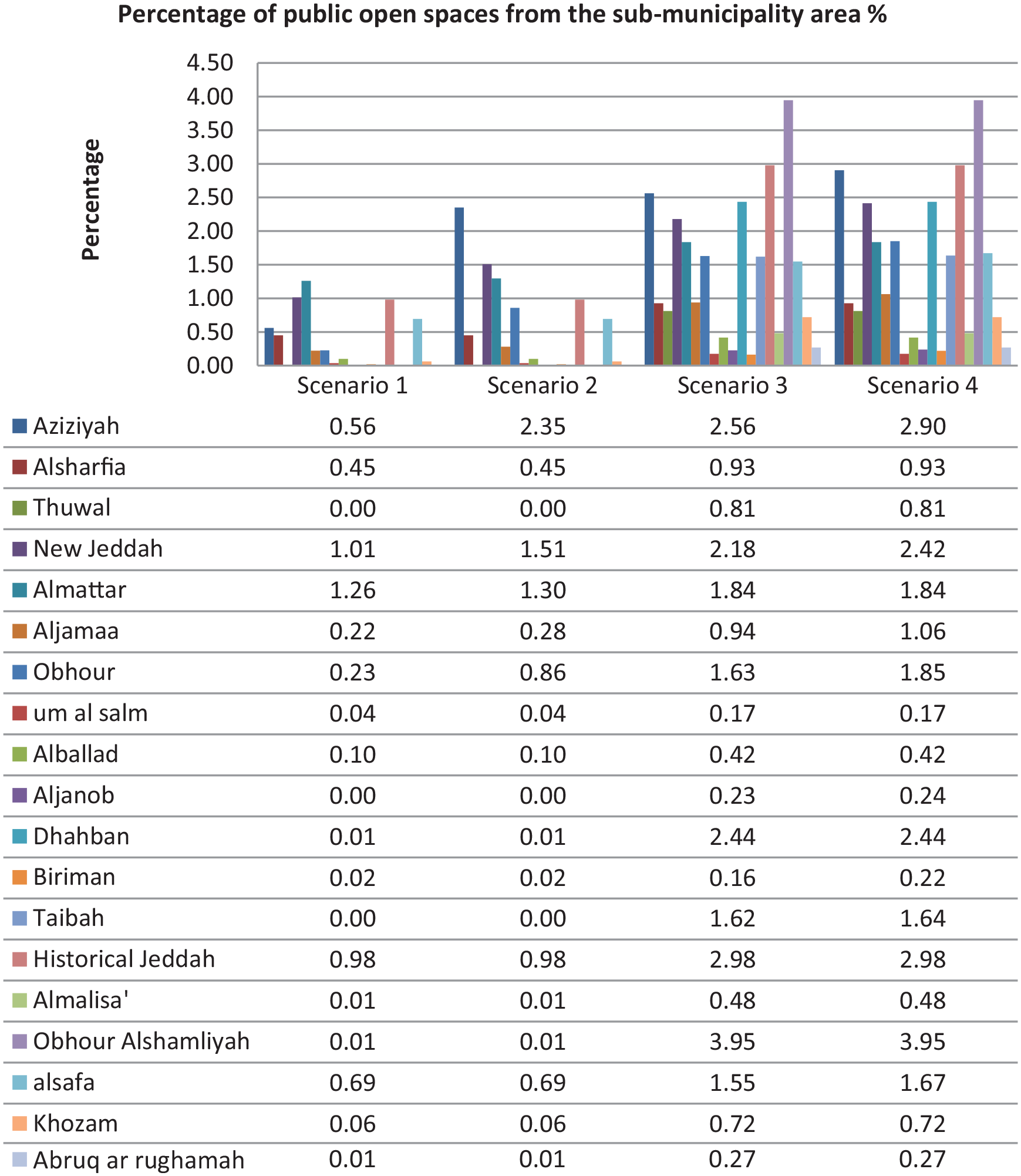
Percentage of the POS area for each submunicipality in Jeddah.
From the review of the first and second scenarios, which present the existing situation in Jeddah, we found evidence that Jeddah suffers from a lack of public open spaces. This is because, in the last few years, the focus has been on providing additional residential land, and this has led to rapid urban expansion in the city and the neglect of the green infrastructure (Addas, 2015). In addition, when comparing the result of the existing open spaces with the JUO (2016) report, which indicated that Jeddah had about 7 m2 per capita in 2015, we found inconsistencies. By reviewing the JUO report, we found that there is a miscalculation in the per capita figure. Data for each district were calculated separately and then the result of each was combined and divided by the total number of districts. In addition, central medians, roundabouts (traffic circle), and road edges were part of this calculation as the municipality considers them to be public open spaces. These are amenity spaces and cannot be usable spaces (Transportation Research Institute, Oregon State University, 1996) unless they designed to be used with extra consideration to the users’ safety and accessibility (Sankalia, 2014).
The results from the third and fourth scenarios indicate that Jeddah could reach the WHO minimum of 9 m2 per capita (WHO, 2010). However, it is important to emphasize that the calculation in this study did not take account of future increases in the population. Jeddah’s population is increasing by 3.5% annually, which means that, from 2010 to 2029, about 2.25 million people are expected to be added to the population (Global City Focus Jeddah, 2016). Therefore, city policymakers should adopt a systematic approach to enhancing the spatial planning of open spaces to meet the international standard and benefit the city and its residents. Moreover, MoMRA needs to adopt one of the international standards or create a national standard for public open space per capita that reflects the country’s characteristics in terms of weather, social preferences, and planning patterns.
The findings of this study also reveal that the city lost around 1,591,366 m2 between both fully occupied and new districts. The land use changed to either residential (building or villas) or religious (mosques) in most cases. It is important to note that, when the municipality approves a master plan for the districts, there are requirements of land use that are supposed to be met according to MoMRA guidelines, which include religious land use. However, from the investigation, we find out that some mosques are donated by different people from the community and, in these cases, land allocated to gardens is used.
Although the WHO recommends that the cities should have a minimum of 9 m2 of public green space per capita, this area is only viable if the space is accessible (Fan et al., 2017; Takano et al., 2002; Thompson, 2002), safe (Francis et al., 2012; Frumkin, 2003), and with suitable activities and facilities (Singh et al., 2010; Villanueva et al., 2015). Unless these requirements are met, the suitable open space per capita will be compacted. Thus, urbanized cities in practice require 50 m2 per capita, depending on the city population density and total area, which should be reflected in the city master plan (WHO, 2010). All countries have applied the numbers and attributes mentioned in this study in different ways to ensure the provision of suitable, accessible, safe, and usable spaces because of the various benefits and values that these spaces offer. Various studies have identified the importance of considering the spatial distribution of public open spaces and the per capita of these spaces according to the city’s population (Fuller & Gaston, 2009; Kabisch et al., 2016; Russo & Cirella, 2018).
Open Spaces’ Spatial Distribution
Although the accessibility assessment showed that there were gaps in the spatial distribution of open spaces, when assessing the third and fourth scenarios using the MoMRA or WHO and EN standards, we found that the city could perform well and the majority of the residents could be served. However, policymakers need to consider creating a typology for the city with different categories of public open space in different residential areas, or the city will be a long way from achieving international standards and the national target (Maruani & Amit-Cohen, 2007; Masoumi et al., 2019; Zamanifard et al., 2018). Taking this step will help the city to deliver types of public open space which serve different uses and demands.
Quantity and Quality
It is important to state that this study looked at the open spaces as numbers without investigating the value and quality of these sites. Other studies (Addas, 2015, 2017; Addas & Rishbeth, 2018; Alawi & Mostafa, 2019; Aljoufiea et al., 2012; Mandeli, 2008, 2010, 2019; Yoseph, 2017) have explored the quality of open spaces in Jeddah and highlighted the importance of identifying a systematic structure for the municipalities and MoMRA to enhance the provision of public open spaces.
Public Open Space Network
We found that the concept of an open space network is not effective in Jeddah city; gardens and parks are not working to link the city services or to enhance walkability (Hepcan et al., 2006; Von Schönfeld & Bertolini, 2017). If the city was designed with consideration to a public open space system, it would perform well and encourage residents to walk and reduce dependence on cars (Rahman & Nahiduzzaman, 2019). There is a need to understand the importance of this network within the planning process to enhance the accessibility to the spaces.
Conclusion
This study examined the public open spaces per capita in Jeddah and found evidence of misguided planning practices resulting from a lack of understanding of the importance of these spaces, not only for residents but also for the city’s different sectors. Planning practices affect the built, natural, and human environments of the city. Western literature and practice use public open spaces as a major tool to enhance the life quality and improve physical, mental, social, economic, and natural well-being of cities and people.
Saudi Arabia is creating several programs to enhance the life quality; however, these programs could have negative impacts if the aim is simply to achieve the KPIs, as is the case of the public open spaces per capita target in Saudi cites. There is a need to build capacity in MoMRA and municipalities with expert Saudi planners and designers and involve them in the urban transformation of Saudi cities. This will lead to the need for a public open space typology, system, and network in all Saudi cities.
This study indicated that Jeddah could have a good level of public open space per inhabitant if all proposed and unbuilt spaces were implemented. However, there is a need to establish a proactive framework that enhances the quality and value of the spatial distribution of the spaces in the city.
Finally, MoMRA and the municipalities in Saudi cities need to adopt a collaboration system to support the implementation of public open spaces. This study revealed that, currently, 24% of the planned open spaces are unbuilt, due to funding of design, operation, and maintenance. Collaboration and partnerships with the private sector would reduce the financial load on both the ministry and the municipalities.
Footnotes
Declaration of Conflicting Interests
The author(s) declared no potential conflicts of interest with respect to the research, authorship, and/or publication of this article.
Funding
The author(s) received no financial support for the research, authorship, and/or publication of this article.