
Abstract
Te Tiriti o Waitangi (The Treaty of Waitangi) is often called the founding document of Aotearoa New Zealand. Although Te Tiriti o Waitangi is referenced in resource management and planning legislation, current spatial planning practices are less than responsive to Māori (the Indigenous peoples of Aotearoa New Zealand) aspirations or ways of knowing. There have been calls to revise spatial planning practices beyond consultation, and to foster Māori-led initiatives informed by traditional knowledge. A variety of institutional web-based geospatial tools have been developed at the national level to assist Māori with spatial planning. However, examples of communities developing their own spatial planning tools are rare. This article presents and discusses the findings of a collaborative research project with Ōhinemutu village in Rotorua, North Island, Aotearoa New Zealand. This research is part of an international movement fostering bicultural and Indigenous-led planning through the co-creation of geospatial tools.
Introduction
Māori (the Indigenous peoples of Aotearoa New Zealand) have spatial planning traditions dating back long before colonisation and the introduction of British planning systems. More than 6900 pā (defensive hillforts) and kāinga (villages) documented in the archaeological records (Anderson et al., 2014) are testament to this long planning tradition. A rich body of knowledge has developed over many generations through the practice of Indigenous planning in a diverse range of traditions and contexts (Matunga, 2013). Prior to World War II, essentially two planning traditions co-existed. The British planning system dominated urban environments while Indigenous systems persisted in village and rural settings where most Māori lived. As the nation industrialised, during and post WWII, there was a steady drift of people to towns and cities. Māori planning systems were not recognised by the colonial project (Tapsell, 2014). Territorial authority regulations, rules, zoning practices and policies limiting the number of dwellings per title, served to alienate Māori from their whenua (ancestral lands), their economic base and traditional ways of living. The Māori Affairs Amendment Act 1967, coined the Land Grab Act, which increased the powers of government-appointed Māori Trustees to compulsorily acquire and sell so-called uneconomic interests in Māori land was one of many measures to facilitate this alienation (Hamer, 2010). Facing the twin pressures of coloniality and urbanisation, many papakāinga (Māori villages on ancestral land) and marae (Māori cultural meeting places that include the ancestral meeting house and other buildings) went into serious decline or ceased altogether. Disenfranchisement from their natural resources, lands and livelihoods has fractured Māori relationships with the environment and hindered their ability to practice kaitiakitanga (environmental guardianship) (Jackson, 2020; Matunga, 2013).
Spatial planning legislation in Aotearoa New Zealand acknowledges the Te Tiriti o Waitangi (The Treaty of Waitangi) and recognises the role of Māori as kaitiaki (guardians, custodians) and requires local and regional authorities to engage with Māori (Resource Management Act, 1991 (NZ), Local Government Act, 2002 (NZ)). Despite this, regulatory provisions are often undermined. Structural inequalities and institutional racism influence discretionary interpretations of policy (Norris & Nandedkar, 2022). The British planning system continues to take a hegemonic stance in Aotearoa New Zealand, disrupting and discouraging Indigenous ways of planning (MacArthur & Bargh, 2022). Māori approaches to spatial planning remain largely unrecognised, ignored and misunderstood and thus underutilised. Communication between planners and Māori communities is frequently poor, and meaningful engagement, beyond consultation, is rare. Māori perspectives and ways of knowing continue to be suppressed by a legacy of coloniality and marginalisation (Awatere et al., 2008; Harmsworth, 1997; Matunga, 2000, 2018; Porter et al., 2017; Whangapirita et al., 2003).
There have been calls for a more inclusive planning system, reflecting the unique bicultural make-up of Aotearoa New Zealand, (Lenihan & Bartley, 2016). A bicultural society was envisaged where
Māori could speak their own language, pursue their own traditions, have their own educational institutions such as kōhanga reo (preschool Māori language nests), kura kaupapa Māori (Māori-language immersion schools) and whare wānanga (universities), provide their own social services, and control their own businesses. (Phillips, 2015, p. 12)
Biculturalism requires the recognition of Indigenous sovereignty. This requires current spatial planning approaches to go far beyond consultation, and to actively decolonise power relations, processes and outcomes (Livesey, 2016; Matunga, 2000, 2013). In a genuinely bicultural planning system, decision-making should centre on local mātauranga (traditional knowledge) and be led by tikanga (customs) (Harmsworth, 1997; Lenihan & Bartley, 2016; Matunga, 2000; Oliver, 1994).
In our research and practice presented in this article, we adopted a partnership approach underpinned by kaupapa Māori (Māori principles) and action research methodologies with the aim of empowering iwi (tribes) and hapū (subtribes) in spatial planning, specifically in developing planning tools with Ōhinemutu village in Rotorua, North Island Aotearoa New Zealand. Te Kete Kōrero o Ōhinemutu (a digital repository for holding narratives about Ōhinemutu village) was co-created in collaboration with Te Manatōpū Hau Kāinga o Ōhinemutu (the legal entity which represents Māori living in Ōhinemutu village; literally the incorporated society of the local people of Ōhinemutu) (TMHKO). TMHKO is, tasked with the revitalisation of Ōhinemutu village, hereafter Ōhinemutu, to meet the community’s collective aspirations. Located on the southern shores of Lake Rotorua, North Island, Aotearoa New Zealand, with a continuous history stretching back more than 600 years, Ōhinemutu is famed for its ngāwhā (geothermal phenomena). The community aspires to use learnings from the research and the tool for support in leading community planning projects and processes, and to strengthen the protection and integration of mātauranga Māori (traditional Māori knowledge) in spatial planning. This is both within the Ōhinemutu as well as the whenua of the wider Ngāti Whakaue (a tribe associated with Lake Rotorua, North Island, Aotearoa New Zealand) and Te Arawa (a confederation of Māori tribes and subtribes who trace their ancestry to the Te Arawa migration canoe). This article presents the methodology developed in the co-creation process as well as describes key aspects of the tool. While this research situates in the cultural context of Aotearoa New Zealand, the article findings are relevant to international, Indigenous and post-colonial contexts, wherever the strengthening of bicultural planning, processes and outcomes are required.
This article is structured in five sections. First, we contextualise biculturalism within spatial planning and the emergence of cultural mapping tools in both in Aotearoa New Zealand as well as internationally. In the second section, we present our case study and the partnership approach taken which breathed life into the project. In the third section, we outline the methodology and the critical steps, practices and methods involved in the co-creation processes in the development of Te Kete Kōrero o Ōhinemutu. The fourth section details the story of the tool and its key findings, its functional architecture, design, access and security, the visualisation of geospatial datasets, the creation and storage of cultural narratives, and the management and governance of the tool. The article concludes with a discussion of key considerations for the future of cultural mapping led by the Ōhinemutu community to meet their own aspirations as well as ramifications of our research findings within the wider context of bicultural and Indigenous-led spatial planning.
Bicultural planning and mapping tools
Māori communities hold aspirations to be fully recognised as Treaty partners in bicultural planning with strong and varied interests in the planning of settlements (Lenihan & Bartley, 2016). Māori seek to regenerate natural and built environments, enhance the resilience of their communities and increase the well-being of both people and natural resources (Matunga, 2020). There is a growing movement by Māori who have been disconnected from their whenua to reconnect with their people, to come back home, physically, mentally and spiritually, and to live in more traditional ways and collective settings. Ways of living are being sought that interconnect and nurture the development of people, land and the environment. Contemporary papakāinga are emerging across the country, both in response to the housing crisis and as an expression of cultural reclamation. Cultural mapping initiatives can play a vital role in fostering the reconnection of communities through shared traditions, histories and lived experiences. Cultural mapping tools centred on mātauranga and tikanga, taking place-based approaches, have been identified as a way to assist Māori-led and bicultural planning initiatives (Tapsell, 2014). Over the last two decades, there has been a gradual upsurge of Māori groups using geospatial science to support Treaty claims, cultural impact assessments, environmental monitoring, land use planning and papakāinga development (Hudson et al., 2020; Pacey, 2005; Walker et al., 2021). This is part of a international landscape of Indigenous peoples around the globe undertaking mapping projects and developing geospatial tools to help address tribal aspirations.
In Aotearoa New Zealand, most cultural mapping tools that aim to support Māori communities in spatial planning have emerged from institutional settings. Governmental entities have developed a range of web-based tools. Pātaka Whenua (an online land information service; literally, storehouse of the land) operated by Te Kooti Whenua Māori (Māori Land Court) that stores data and links landholders geospatially to customary and Māori Freehold Land with details on block information, documents, management structure and ownership. Formerly called Māori Land Online, the recent addition of access to documents pertaining to land, such as trust deeds and minutes, greatly enhances the experience of users of the service. WhenuaViz, developed by Maanaki Whenua Landcare Research in 2009, brings together useful information on the environmental characteristics and potential land uses of Māori land blocks. There are irregular updates to data and links with the last being in 2020. Tupu.nz, developed by the Ministry of Business, Innovation and Employment, aims to help connect whānau (extended family) members with their land for the purposes of development and investment. Like WhenuaViz, it also provides information on environmental characteristics and land use potential. While useful for some Māori planning purposes, these tools are not interactive or designed to actively incorporate the perspectives of local communities, with governmental agencies dominating the control and provision of selected data.
Māori Maps and Kā Huru Manu (Ngāi Tahu [a tribal group, South Island, Aotearoa New Zealand] Atlas of placenames and histories) were developed by Māori-led organisations. Kā Huru Manu was created by Ngāi Tahu as an online map of their entire takiwā (tribal territory) showing traditional place names, routes and Māori land. Currently, there are more than 1500 place names, currently displayed on the map, making Kā Huru Manu one of the largest Indigenous mapping exercises in the world (Dimond, 2018). The process to achieve this, has been comprehensive and inclusive, including a strict validation process involving rūnanga (tribal authority) informants. Māori Maps links Māori, and others, to marae, support and opportunities through maps, geographical information and photographs (Tapsell, 2014). For tribal members looking at reconnecting to their whenua, this tool is often their first stop. These tools contain useful broadscale information, however, their ability to receive, hold and provide locally relevant, place-based data is limited. There are few examples of bespoke geospatial tools being built for community and Māori-led spatial planning that braid place-based and institutional knowledge. Despite this, geographic information system (GIS) involvement by Māori communities is widespread and growing. Ngā Poutama Matawhenua (a programme of Māori focussed monthly online mapping workshops; literally, patterns in geography) provided by Toitu Te Whenua—Land Information New Zealand. Te Kahui Manu Hokai (National Māori GIS Association) holds occasional conferences and workshops. Both initiatives are well attended with a range of geospatial projects presented including the development of papakāinga.
Across Aotearoa New Zealand there are good examples of flax roots collaborations between Māori communities and research institutions that have led to the development of a range of place-based environmental monitoring tools. Cultural health assessment tools have been developed to evaluate and report on the health of freshwater, wetlands, estuaries, marine environments, forests, soils and agricultural activities (Chua-oon Rinfret et al., 2022; Harmsworth & Tipa, 2006; Walker, 2019). Such tools have been developed and tested in the context of improving kaitiakitanga and resource management; however, they often lack digital and geospatial capability to efficiently collect, collate and communicate spatial information. While local and national authorities frequently refer to such tools within official reporting systems, the collation and dissemination of data is often lacking. This can sometimes be due to a lack of political will for Māori-led initiatives but, more frequently, it is a absence of technical and geospatial capability among Māori communities. The use of data by government agencies for purposes that it was not initially intended for have served to erode the trust and confidence of Māori communities and slowed the development of cultural mapping and tools to support it.
Ōhinemutu village, Rotorua case study
Takahia atu rā ki Te Papaiouru ki runga ki Pukeroa, Mātakitaki iho Ki Ōhinemutu, ko Muruika, ko Tamatekapua. Ko Whakaue Kaipāpā e tū nei. (Traverse [the ground] to Te Papaiouru at Pukeroa. Look below to Ōhinemutu, [where stands] Muruika, and Tamatekapua. ‘Tis Whakaue Kaipāpā upstanding). (Rangitauira & Flavell, 2022, p. 129)
Ko Ōhinemutu te ūkaipō o Ngāti Whakaue (Ōhinemutu is the ancestral home of Ngāti Whakaue). The name Ōhinemutu was bestowed on the village by the Te Arawa tupuna (ancestor) named Ihenga. After landing with the Te Arawa waka hourua (migration canoe) Ihenga ventured inland and settled for a while at Ōhinemutu along with his family. Ihenga had a daughter, Hinetekakara, who was named after her mother. One day when Ihenga was away on his travels, a neighbouring tribe came and took Hinetekakara, then killed her leaving her remains hanging from a tree. In his grief Ihenga stated the words “Oi e Hine, mutu koe i ahau i tēnei rā (and so Hine, your time with me has ended)” hence the name Ōhinemutu. Ihenga was a prolific traveller and explorer and went on to name large parts of the North Island from the Rotorua area and northwards (M. Kingi, personal communication, 2024).
Early European visitors to Ōhinemutu commented on the thermal activity and the uses made of the various hot springs. Some ngāwhā were used for communal bathing others for washing of clothes, while the hotter ngāwhā were used for cooking (Figure 1). Therapeutic uses of the springs were noted. “(T)hey possess valuable medicinal qualities both for internal use and external application, as the natives cure many diseases by simple immersion in them” (Johnson [1847], as cited by Stokes, 2000, p. 173). The arrival of Europeans also heralded the rise in tourism to the area with Ōhinemutu being the departure point for excursions to the famed Pink and White Terraces, until their demise with the eruption of Mount Tarawera in 1886. Ōhinemutu also became the point at which the township of Rotorua later emerged. Ōhinemutu is still a papakāinga for Ngāti Whakaue of which the majority of its residents are direct descendants. Aiming to address the limitations highlighted in the review, this research adopted a case study and partnership approach. Ōhinemutu village was selected due to its unique spatial planning needs underpinned by its people, history and location.
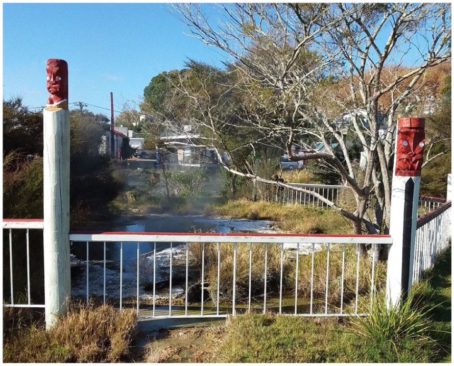
Great Waikite, a ngāwhā (geothermal phenomena) at Ōhinemutu, Rotorua Lakes region, Waikato region, North Island, Aotearoa New Zealand (Photo by authors).
Collectively Ōhinemutu whānau and Ngāti Whakaue hold a treasure trove of place-based mātauranga, most obviously expressed between the people and their relationship with their ngāwhā. A research partnership was initially formed between the Geospatial Research Institute Toi Hangarau, University of Canterbury (GRI) and Te Tatau o Te Arawa (a partnership entity between Te Arawa and Rotorua Lakes Council). Te Tatau o Te Arawa represents Te Arawa in the partnership, including Ngāti Whakaue. The umbrella of an incorporated society enhanced the community’s ability to led and manage a range of projects in the village as well as their ability to engage in collaborative research. Te Tatau o Te Arawa facilitated the development of the relationship between GRI and TMHKO which has recently been formalised through the signing of a memorandum of understanding. The memorandum was co-created by the two parties in the partnership, recognises data sovereignty as being held by the Ōhinemutu community and acts as a means for the facilitation of future collaborative research. Sustaining the formal agreement, informal relationships based on trust and reciprocity have been developed and maintained between the research team and the Ōhinemutu leaders and community.
Methodology
Our methodology combines Kaupapa Māori Research and Action Research and is underpinned by the whakataukī (proverb),
He moana pukepuke e ekengia e te waka (Choppy seas can be navigated by a solid canoe)
Kaupapa Māori research often takes fluid, rather than deterministic approaches to methods, highlighting foundational principles such as tikanga Māori (Māori customs) and whakapapa (genealogical connections) to design and undertake research activities (Smith, 2012). Action Research can be envisaged as a set of self-reflective practices aimed to foster knowledge production with communities. McNiff (2013) argues that action research enables studied communities to act as co-researchers, through critical self-reflective approaches that can challenge the status quo of knowledge production and application. In the context of spatial planning, action research in Aotearoa New Zealand can be conceived as an unfurling frond, each koru an iteration of planning, action, observation and reflection (Walker, 2019).
This research adopted a partnership approach, underpinned by trust, reciprocity and reflectivity of the Te Tiriti o Waitangi. Our collaborative steps built on existing organisational structures and planning priorities, which enabled meaningful co-creation processes. For this, He Awa Whiria (the Braided Rivers approach) helped weave together the strands of local mātauranga and scientific knowledge (Macfarlane et al., 2015). It served to guide practices of care and ethics, networking of local knowledge systems, and power sharing throughout the research (Dionisio et al., 2021). As a set of practices, co-creation involves more than formal or transactional research activities, it includes regular interactions, active listening and communicative skills to set the premises of shared work. Both the efforts and benefits of co-created research outputs are shared among research partners.
Earlier in the project, the Ōhinemutu community expressed aspirations to improve their spatial planning capability, and to lead spatial planning in the regeneration of their village. The community envisioned a geospatial tool to improve the visibility, connectivity and utility of mātauranga pertaining to Ōhinemutu as well as help prevent the loss of the collective knowledge of the village. As an initial point of focus TMHKO wanted to document cultural narratives around the relationship between people and their ngāwhā. Early research steps included a review of existing cultural mapping tools used by Māori around the country for spatial planning purposes. This served to understand the gaps between Ōhinemutu whānau aspirations against the national backdrop of available cultural mapping tools and their functionalities.
This research step was followed by the co-creation of a functional prototype of the tool, conducted through a series of iterative cycles of planning, action, observation and reflection. Mirroring the partnership, the co-creation processes involved researcher partners, both in the Ōhinemutu community as well as those from the university, including researchers and software developers. Research practices involved active maintenance of relationships, through rounds of hui (meetings), fieldwork and research activities, which nourished the conceptualisation and design of the tool. The prototype of what came to be known as Te Kete Kōrero o Ōhinemutu was populated with test geospatial layers of interest including web-based services provides in the public domain. A layer was developed locating and naming ngāwhā with examples of cultural and scientific narratives about selected ngāwhā upload to the prototype by community members and university researchers. Named ngāwhā are located by the red dots on the aerial imagery in (Figure 2). This was undertaken to test the tool and advance the functional responsivity of the tool while maintaining the security of the data, of which the data sovereignty irrevocably belongs to the community.
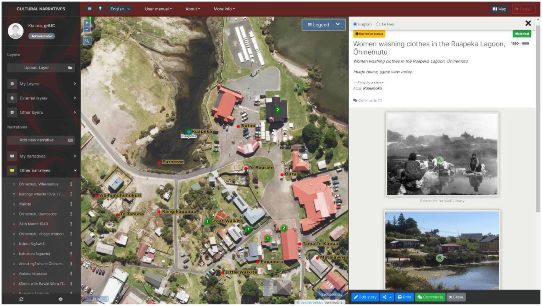
Functional prototype of Te Kete Kōrero o Ōhinemutu (a digital repository for holding narratives about Ōhinemutu village) (Photo by Luke Parkinson).
Initially our research practice included regular visits to Rotorua and Ōhinemutu; however, these were disrupted by COVID-19 restrictions from March 2020 onwards. While our practice of whakawhanaungatanga (the practice of relationship building) was negatively affected, for example having to adapt from kanohi ki te kanohi (face to face) into regular online meetings, the strength of our relationships prevailed and enabled us to continue with the research.
Results
Since colonisation, spatial planning in Aotearoa New Zealand has generally taken top-down approaches led by local authorities following a British planning tradition. Planning outcomes in Ōhinemutu have generally been poor demonstrating various acts of spatial injustice such as the local authority taking over legal ownership of the roads running through the village (NZ Press Association, 1974). This subsequently led to sewage pipes being laid through the village along these road lines which resulted in negative outcomes for the community. Te Kete Kōrero o Ōhinemutu was co-created by the Ōhinemutu community and university researchers in response to a real need for a local community planning tool. Te Kete Kōrero o Ōhinemutu is fit-for-purpose to support Ōhinemutu whānau take the lead in undertaking spatial planning their village rather than having it happen to them. The initial focus of the community was to collate and archive mātauranga about their ngāwhā as the hot springs are unique to the cultural identity of Ōhinemutu. Over 30 named ngāwhā were identified, with their locations mapped and selected characteristics of each recorded. Some ngāwhā have changed their location over time, others have changed their temperature or chemical composition, altering their use and relationship to the community. Residents and community leaders of Ōhinemutu provided narratives on lived experiences, traditional and historical information running through the village. Examples were uploaded to the prototype tool. In parallel university researchers facilitated the investigation and uploading of selected historical and scientific geothermal narratives, mainly sourced from the National Library and scientific journals. The tool allows for narratives to be developed or co-developed by tool users using a range of media including text, photographs and video. The following sections focus on specific functionalities of Te Kete Kōrero o Ōhinemutu: access, security and governance of the tool; architecture of the tool; design of the tool; concluding with a section on developing cultural narratives for upload to the tool.
Access, security and governance
TMHKO required a sound management and governance structure to ensure appropriate access to and the security of mātauranga. Four levels of access and security were identified, each level awarding degrees of rights and obligations, these being: tool manager, administrator, verified user and non-verified—or public, users. Tool managers facilitate the registration process for intended tool users including verification that the applicant is Ngāti Whakaue and to which koromātua (subtribe) they whakapapa to. Tool managers include kaitiaki whose role it is to authenticate the authors of narratives, the appropriateness of the narratives and the groups to which the narrative is shared. This review process allows multiple narratives of the same place and same events allowing divergent perspectives. The process enables feedback to authors so that they might to improve the content of their narrative about a place. Only after authenticated, can cultural narratives be published to wider, designated levels of access within Te Kete Kōrero o Ōhinemutu. Tool managers help direct the engagement processes necessary to collect and archive cultural narratives into the tool.
The main role of the administrator is tool maintenance. They have the same privileges as tool managers, but they also have additional ability to upload layers and cultural narratives open to all users to the tool. Verified users first need to establish an account which gives them the ability to access the tool, upload and share GIS layers and cultural narratives. They then have the ability to develop and freely share narratives within their whānau. Verified users also have the ability to submit narratives to wider koromātua, Ngāti Whakaue or public levels. Non-verified users can access the tool via the website; however, the functionalities, levels of access and cultural narratives available are limited.
Architecture of the tool
Te Kete Kōrero o Ōhinemutu was co-designed as a web-based tool, to securely hold and communicate mātauranga of Ōhinemutu. The architecture of the tool is built upon open-source technologies, including its database and catalogue libraries. The base layers are OpenStreetMap and NZ Aerials. To foster the co-creation of future, similar cultural mapping tools, with the ability to serve Indigenous communities in spatial planning elsewhere the tool’s software code is publicly available. The code provides the functionalities of the tool but no data or front end. Tool users can add, categorise and search geographical and cultural information. Cultural narratives can be geographically located using points, vector lines or polygon areas. Te Kete Kōrero o Ōhinemutu utilises an Indigenous Atua (deities) based framework to categorise narratives for sharing and retrieving. The framework features seven atua who hold guardianship over various domains of the natural world (Walker et al., 2021). Each narrative can be associated with at least one atua. Narratives about ngāwhā, for example, might naturally be categorised under the Rūaumoko (deity of earthquakes, volcanoes and geological phenomena) as his domain is that of earthquakes, volcanoes and other geological phenomena. But narratives are diverse, for example, a narrative that includes the processing of harakeke (flax; Phormium tenax) in a hot spring would also attract the category of Tāne (deity of birds and forests). A generic Atua framework helps embed te ao Māori (Māori worldview) within the tool, highlights whakapapa relationships and provides an interface for Indigenous and Scientific streams of knowledge. The community expressed a desire to develop their own specific kaupapa Ōhinemutu (Ōhinemutu principles) framework, but this was not possible through to timing constraints. There are four levels to which narratives can be published—whānau, koromātua, iwi and public. At the whānau level narratives can be shared freely between authors and their whānau, without any need for formal validation. Validation is achieved through kōrero (discussions) between the authors and whānau members. For narratives which are deemed by their authors to have wider appeal at either the koromātua, iwi and public levels there is a review and validation process by kaitiaki in Ōhinemutu to assess their appropriateness to being published at those levels.
Design elements
The co-design process ensured that the tool was place-based. The front end of Te Kete Kōrero o Ōhinemutu reflects the way in which the community identifies itself including graphics, patterns, colours, text fonts and sizes within the web pages. Local Ōhinemutu background images, symbols and te reo Māori (the Māori language) feature. As a contribution to the revitalisation of te reo Māori, critical from the perspective of the community, the tool has both English and te reo Māori versions. An essential element was to enable the visualisation of a variety of geospatial information including governmental and community data. Geospatial data are imbedded in the tool via external and internal layers. External layers are live datasets from external Application Programming Interface services such as the Aotearoa New Zealand aerial imagery and property title datasets provided by the Land Information New Zealand. Internal layers are datasets, such as the Māori Lands dataset provided by Te Kooti Whenua Māori and the Ministry of Justice. Internal layers are not live so depend on regular updates by data-providers as new data releases are made available which, in turn, requires regular manual updates by the tool administrator. In addition, tool users can add their own geospatial layers as My Layers. They have the ability to share these layers to other users as well as change the style, rename layers, access data attributes and so forth.
Cultural narratives
Members of Ōhinemutu community and Ngāti Whakaue affiliates, who have been authenticated through the verification process to become tool users, have the ability to create cultural narratives either individually or in groups. These include traditional, historic and scientific narratives as well as lived experiences associated with the geographies of the village. Narratives are created and stored in the My Narratives section of the user’s account They can be co-authored with other verified members chosen by the creator. Multiple narratives, even conflicting versions, about the same event and place are seen as valid and are permitted. Tool users can associate to specific groups, share access to their narratives and provide feedback and comments to other narratives. Narratives which have been through the verification process for sharing are displayed as “Other narratives” (Figure 2). In the example “Women washing clothes in the Ruapeka Lagoon, Ōhinemutu” (Figure 2) is an historical photograph of the Ruapeka Lagoon compared to a photograph taken from the same point. The location of the Ruapeka Lagoon is highlighted in the aerial imagery (Figure 2). The creation of cultural narratives is user friendly. Narratives can be composed of a variety of media including text, images, audio and video, and a variety of traditional forms such as mahi toi (arts and crafts), pūrākau (traditional legends), mōteatea (poetry), waiata (songs), whakataukī and so forth. Tool users have the ability to draw geographical features on the map and associate these with specific parts of the narrative. Each narrative has an author, at least one location, a date—estimated or precise and distinct levels of access. Methods of exploring the tool can be through the map—geospatial, through whakapapa—tupuna, whānau and koromātua, through a timeline—temporal—or through the Atua framework. Elements within a narrative can be reordered by drag and drop to structure the narrative as preferred.
Discussion
The story of Te Kete Kōrero o Ōhinemutu exemplifies the potential of place-based approaches to shape research partnerships and advance cultural mapping and its relevance to spatial planning. The project aimed to co-design and co-create a cultural mapping tool with the Ōhinemutu community to better integrate mātauranga ki Ōhinemutu (knowledge in Ōhinemotu) into spatial planning processes. This involved a collaborative and partnership approach, initially with unclear methodological pathways but with a strong commitment from involved parties. Key to the success of this collaboration were whakawhanaungatanga relationship building practices, critical to nurturing the partnership between TMHKO and the Geospatial Research Institute. The partnership, described through He Awa Whiria, intertwined scientific and place-based knowledge, resulting in the development of the mapping tool.
Residents of Ōhinemutu, particularly those of Ngāti Whakaue descent, are primary users of Te Kete Kōrero o Ōhinemutu. The tool also serves as a connection point for others who live away from the village. They may have an association with the village, have become disassociated with it through time and circumstance and now aspire to reconnect, even contribute. The tool’s inclusive design allows diverse users to engage with it for diverse purposes, empowering the community in spatial planning and building upon the rich cultural history of Ōhinemutu.
Moreover, it strengthens the integration of mātauranga Ōhinemutu into village planning processes, contributing to Indigenous sovereignty and self-determination. The community is better able to both participate in and lead spatial planning initiatives. The tool has the potential to improve spatial planning system in Aotearoa New Zealand to be more bicultural in its approach. The architecture and functionalities embedded in the code of the tool provide optimistic points of reference, particularly for small and Indigenous communities who have aspirations to develop their own spatial planning tools.
Conclusion
Te Kete Kōrero o Ōhinemutu represents an innovative approach to web-based cultural mapping, co-designed to connect institutional data with place-based cultural narratives. Its verified registration process ensures data sovereignty and trustworthiness, allowing the Ōhinemutu community to securely store and share their cultural narratives. While the tool has yet to see extensive practical use beyond research, it is poised to play a central role in various community projects, including geothermal heating, solar power, climate resilience and urban regeneration. The recent memorandum of understanding between TMHKO and the Geospatial Research Institute signifies a commitment to further develop and utilise the tool, marking a significant step towards community-driven spatial planning and cultural preservation (Figure 3).
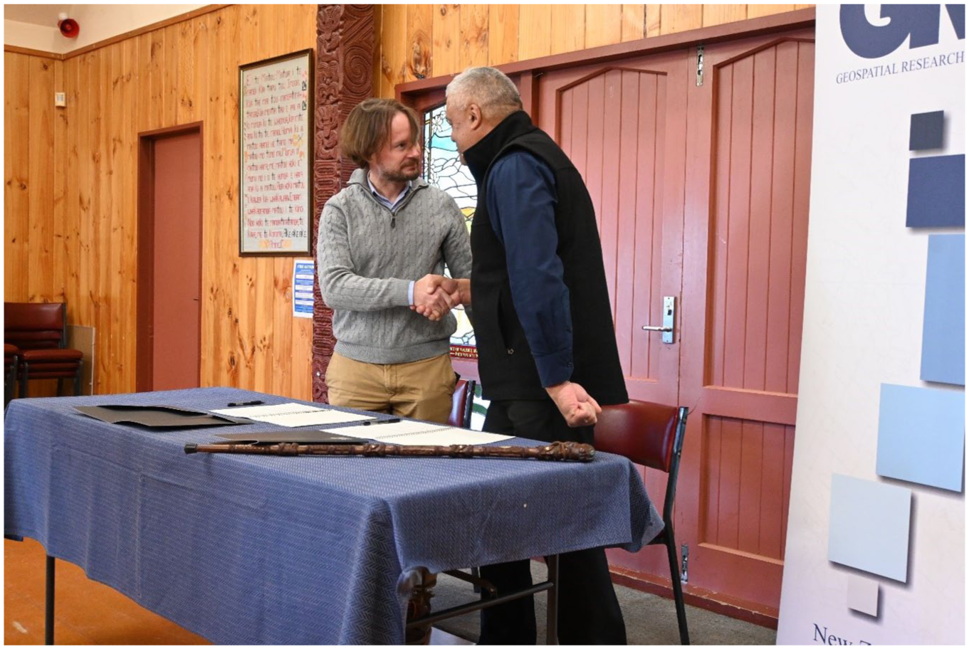
Matt Wilson (l) Director of the Geospatial Research Institute Toi Hangarau and Mokonuiarangi Kingi (r) Chair of Te Manatōpū Hau Kāinga o Ōhinemutu following the signing of a memorandum of understanding between Te Manatōpū Hau Kāinga o Ōhinemutu and the University of Canterbury (Photo taken at Te Ao Mārama, Ōhinemutu, Rotorua by authors).
This research is part of an international effort to promote bicultural and Indigenous-led spatial planning through the co-creation of relevant place-based tools. Although focused on Aotearoa New Zealand, our findings are applicable to other Indigenous peoples in post-colonial contexts who seek to enhance bicultural planning, processes and cultural mapping projects to support their tribal aspirations.
We conclude with the whakataukī,
Titiro whakamuri, kōkiri whakamua (Look back so we can move forward)
Footnotes
Acknowledgements
Te Kete Kōrero o Ōhinemutu was developed in partnership with Te Manatōpū Hau Kāinga o Ōhinemutu, Te Tatau o Te Arawa and the Geospatial Research Institute Toi Hangarau at the University of Canterbury. The research team also includes researchers from Lincoln University and University of Waikato. The project was funded by funded the Ministry of Business, Innovation and Employment’s Endeavour Fund 2017, and includes two case studies—one of which, presented in this article. The authors thank all partners and collaborators in the communities they worked with, for all their time, support and commitment throughout.
Authors’ note
Funding
The authors disclosed receipt of the following financial support for the research, authorship and publication of this article: This work was supported by the Ministry of Business, Innovation and Employment Endeavour Fund (grant no. PROP-52114-ENDRP-UOC).
Declaration of conflicting interests
The authors declared no potential conflicts of interest with respect to the research, authorship and publication of this article.
Glossary
Atua, atua deities
hapū subtribes
harakeke flax; Phormium tenax
He Awa Whiria the Braided Rivers approach
hui meetings
iwi tribes
Kā Huru Manu Ngāi Tahu [a tribal group, South Island, Aotearoa New Zealand] Atlas of placenames and histories
kāinga villages
kaitiaki guardians, custodians
kaitiakitanga environmental guardianship
kanohi ki te kanohi face to face
kaupapa Māori Māori principles
kaupapa Ōhinemutu Ōhinemutu principles
kōhanga reo preschool Māori language nests
kōrero discussions
koromātua subtribe
kura kaupapa Māori Māori-language immersion schools
mahi toi arts and crafts
Māori the Indigenous peoples of Aotearoa New Zealand
marae Māori cultural meeting places that include the ancestral meeting house and other buildings
mātauranga traditional knowledge
mātauranga Māori traditional Māori knowledge
mātauranga ki Ōhinemutu knowledge in Ōhinemotu
mōteatea poetry
Ngā Poutama Matawhenua a programme of Māori focussed monthly online mapping workshops; literally, patterns in geography
Ngāi Tahu a tribal group, South Island, Aotearoa New Zealand
Ngāti Whakauea tribe associated with Lake Rotorua, North Island, Aotearoa New Zealand
ngāwhā geothermal phenomena
pā defensive hillforts
papakāinga Māori villages on ancestral land
Pātaka Whenua an online land information service; literally, storehouse of the land
pūrākau traditional legends
Rūaumoko deity of earthquakes, volcanoes and geological phenomena
rūnanga tribal authority
takiwā tribal territory
Tāne deity of birds and forests
te ao Māori Māori worldview
Te Arawa a confederation of Māori tribes and subtribes who trace their ancestry to the Te Arawa migration canoe
Te Kahui Manu Hokai National Māori GIS Association
Te Kete Kōrero o Ōhinemutu a digital repository for holding narratives about Ōhinemutu village
Te Kooti Whenua Māori Māori Land Court
Te Manatōpū Hau Kāinga o Ōhinemutu the legal entity which represents Māori living in Ōhinemutu village; literally the incorporated society of the local people of Ōhinemutu
te reo Māori the Māori language
Te Tatau o Te Arawa a partnership entity between Te Arawa and Rotorua Lakes Council
Te Tiriti o Waitangi The Treaty of Waitangi
tikanga customs
tikanga Māori Māori customs
tupuna ancestor
Toitu Te Whenua Land Information New Zealand
waiata songs
waka hourua migration canoe
whakapapa genealogical connections
whakataukī proverb
whakawhanaungatanga the practice of relationship building
whānau extended family
whare wānanga universities
whenua ancestral land