
Abstract
This article examines flood risk as an emergent assemblage rather than a fixed or universally agreed-upon condition. Drawing on ethnographic fieldwork, the paper traces how flood risk materializes through contingent relations among human actors, hydrological processes, infrastructures, legal categories and competing temporal imaginaries. Rather than treating planners, experts and residents as stable groups with predetermined interpretations, the analysis follows how these provisional formations are continually reconstituted as they align with different visions of urban futures. Planners stabilize a heritage-oriented redevelopment imaginary, while disaster risk reduction and management (DRRM) regimes regard the area as a high-risk zone. Squatter residents assemble the riverbanks as an urban sanctuary through everyday practices and selective downplaying of flood events. Foregrounding these relational processes, the article contributes to a temporally attuned understanding of urban risk, demonstrating that flood risk is not an external technical reality but an emergent effect of heterogeneous relations that shape and are shaped by competing futures-in-the-making.
I. Introduction
In cities worldwide, flooding and inundation are increasingly becoming part of everyday urban living, particularly for those residing in precarious zones such as riverbanks and floodplains.(1) More often, these spaces of precarity are inhabited by marginalized populations.(2) Yet, it is not simply that marginalized communities reside in dangerous landscapes. Rather, risky geographies emerge when particular populations, materials and histories come into relation with one another.(3) This perspective disrupts the notion of risk as an objective, pre-existing condition and instead foregrounds how risk is continuously produced, circulated and stabilized through social and political processes. Risk, therefore, has no singular essence; it is an unstable and contested effect emerging out of heterogeneous interactions.
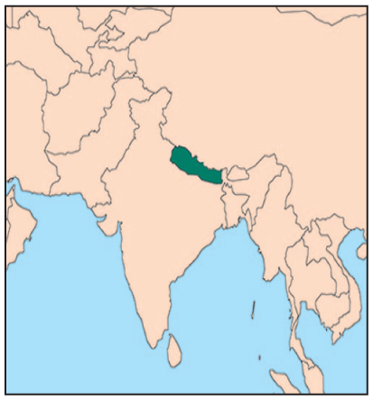
In the Kathmandu Valley in Nepal, urban flooding is a seasonal phenomenon. Climate models project its intensification in the coming decades.(4) The majority of the valley’s squatter settlements are located along riparian zones,(5) rendering them particularly entangled with flooding hazards (see Figure 1).(6) Despite annually recurring flooding and inundation, flood risk in riparian informal settlements remains inconsistently recognized or acted upon within disaster risk reduction (DRR) policies and interventions.(7) Paradoxically, riparian squatters themselves often downplay, normalize or strategically contest the significance of flood risk.(8) While existing scholarship documents this apparent denial,(9) less attention has been paid to how a wider constellation of planners, DRR professionals, state agencies, hydrological processes, infrastructures, legal categories and everyday practices jointly assemble what counts as “risk” along the riverbanks.
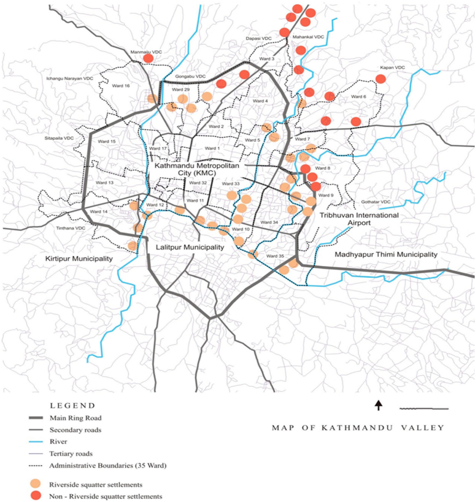
Squatter settlements on the Bagmati Corridor, Kathmandu Valley(10)
This paper, therefore, asks: how do different actors and material processes within Kathmandu’s riparian landscape conceptualize, enact and mobilize flood risk, and to what effect? In addressing this question, we argue that risk is not simply interpreted differently by different actors, but that different articulations of risk are assembled through relational interactions among human actors, bureaucratic practices, infrastructures, the river’s dynamism and competing imaginaries of urban futures. Rather than treating risk as a stable condition, the paper shows how the multiple emergent articulation of risk becomes a flexible instrument for governing and remaking riparian geographies.
The argument draws on ethnographic fieldwork in Pragatinagar Basti, a squatter settlement along the Manohara River, one of the major tributaries of the Bagmati River, originating in the Kathmandu Valley (see Figure 2). The fieldwork is supplemented by interviews with urban planners, DRR managers and government officials. Guided by an assemblage approach,(11) the analysis traces how riparian space is repeatedly territorialized and de-territorialized through the interaction of policies, infrastructures, hydrological dynamics, institutional logics and everyday practices. Three provisional clusters emerge as particularly significant within this assemblage:
The urban planning milieu of municipal and federal officials and planning experts;
The DRR governance regime; and
The residents of Pragatinagar Basti.
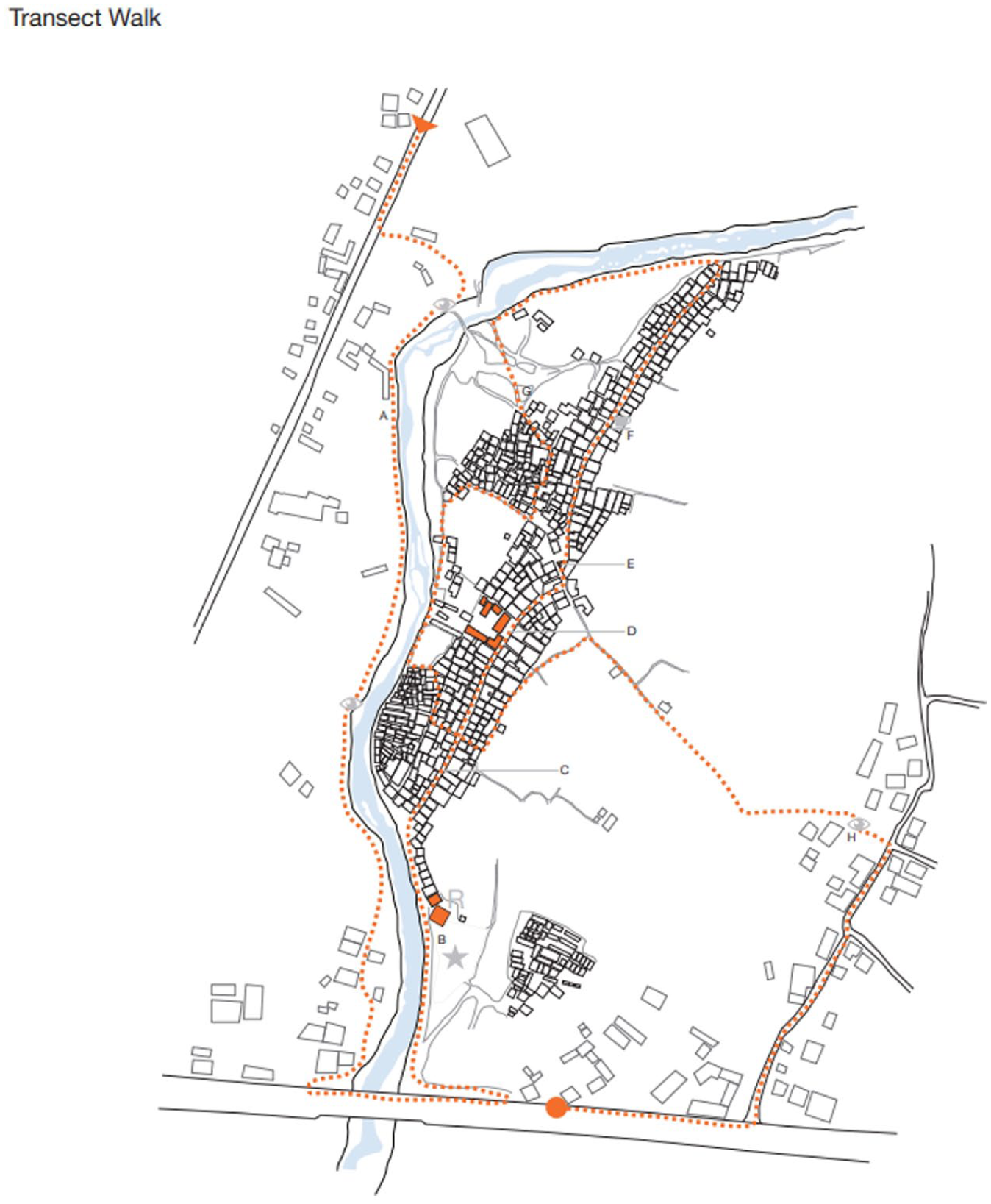
The layout of Pragatinagar Basti along the Manahara River
Planners territorialize riparian space by mobilizing discourses of restoration, heritage and infrastructure-led redevelopment that orient the assemblage towards particular future trajectories. The DRR experts stabilize it as a high-risk zone through hazard mapping and anticipatory logics that performatively produce certain virtual futures as actionable, thereby legitimizing eviction of the riparian squatters. The squatters living in the riparian geography, meanwhile, configure the riverbank as an urban sanctuary, articulating alternative accounts of risks that downplay recurrent flooding events, to modulate a different potential future.
The paper is structured into seven sections. Following the introduction in Section I, in Sections II and III we outline the assemblage framework and the key concepts guiding this analysis. Section IV details the methodology and context, and introduces Pragatinagar Basti, the field site. In Section V, we present the analysis of how different provisional actors assemble and mobilize risk. Section VI discusses flood risk as a future-making technology within riparian governance. In the concluding Section VII, we reflect on the broader implications for understanding flood risk as emergent from a politically charged riparian assemblage. In doing so, the paper contributes to scholarship on urban disasters and risk by demonstrating how risk is continuously reassembled and how riparian geographies are shaped not only by hazards but also by contested planning visions, political negotiations and everyday survival strategies.
II. Assemblage Thinking and Urban Risk
Assemblage theory has been influential in urban geography as a way of examining how heterogeneous elements come together to form provisional, contingent formations.(13) In disaster studies, it helps analyse how diverse social, material, human, more-than-human(14) and discursive elements interact to create provisional, context-dependent disasters and disaster-governance mechanisms.(15) A central strength of assemblage thinking lies in its analytical emphasis on relationality. As such, assemblages do not pre-exist their components; rather, they emerge through the interactions among them.(16) Furthermore, the theory enables attention to elements that are material and immaterial, biophysical and social, human and more-than-human.(17)
Assemblages can be understood as having a quadripartite structure defined along two axes.(18) The first axis is composed of material and expressive elements, each shaped by territorializing and de-territorializing processes. The material side is the machinic assemblage of bodies, infrastructures, objects, flows and affects, and the collective assemblage of enunciation, composed of discourses, classifications and symbolic codes.(19) These dimensions are not separate but co-constitutive.(20) Together, these material and expressive components interact with stabilizing and destabilizing forces to produce the dynamic and continuously reconfigured nature of urban reality.
While the first axis distinguishes between the material and the expressive components, the second traces the processes of territorialization, deterritorialization and reterritorialization – processes that either stabilize or unsettle assemblages. Territorialization refers to the processes through which relations are stabilized, homogenized and bounded.(21) These stabilizations are often supported by coding processes such as discursive classifications, institutional logics and legal categories. Coding processes provisionally fix identities and meanings.(22) Such processes of stabilization, however, are inherently fragile. De-territorializing forces disrupt boundaries, enabling new possibilities for reconfiguration.(23) Every deterritorialization is followed by an immediate reterritorialization. Ranganathan’s work on Bangalore floods exemplifies this process: stormwater infrastructure (pipes, drains, blockages) interacts with colonial planning logics and contemporary governance rationalities that conflate stormwater with wastewater.(24) Flood risk, in this view, emerges not from any single element but from the relational interplay of such materialities and discursive framings.
From this perspective, the paper argues that, when assemblage approaches are employed in conceptualizing urban disaster risks, risk functions as a form of coding that either stabilizes the assemblage or alternatively destabilizes it by accelerating the processes of territorialization or deterritorialization. The capacity to articulate risk (or in other words, to generate discourses that consolidate identities or conversely unsettle them) can be understood as an emergent property of the evolving assemblage. As the assemblage shifts, incorporating new actors, practices and relations, its ability to produce accounts of risk also shifts. In this sense, discourses of risk are not external impositions but products of the assemblage’s changing configurations, differential capacities and desires. Hence, risk is understood as continually in-the-making, produced relationally rather than as a fixed socioenvironmental condition.(25)
III. Virtuality and the Future-in-the-Making
In assemblage approaches, territorialization and coding processes describe how assemblages are temporally stabilized. The concept of the virtual is central to understanding temporality in an assemblage. Virtual, in assemblage theory, is the realm of latent potential that is real but not yet actualized.(26) It conditions how an assemblage can mutate. Deterritorialization disrupts the existing configuration of an assemblage, expanding the range of potentials that may be expressed, while processes of reterritorialization selectively consolidate some of these emergent tendencies within a new, provisional order. However, neither process exhausts nor determines the virtual. They merely shape the conditions under which actualizations occur, leaving the assemblage open to further transformation. Power within an assemblage, therefore, resides in the capacity to modulate the conditions under which virtual potentials may be actualized, emphasizing certain trajectories of becoming while constraining or foreclosing others.(27)
Futures are, therefore, not simply imagined objects located ‘ahead’ of the present. They operate as a virtual potential that exerts force in the present by shaping decision-making, governance practices and material investment. Davis and Groves conceptualize such a process of actualizing the virtualities as “futures-in-the-making”, which are emergent orientations unfolding through a sociomaterial assemblage.(28) While futures are always in process, always partial and never fully knowable, they structure the present actions in concrete ways.(29) These not-yet-actualized processes are empirically elusive but materially consequential, as the actualization can lead to a future of harm for the marginalized. This logic is applied in disaster studies by McGowran and Donovan through the notion of “disaster-in-the-making”, highlighting how disasters emerge through present-day configurations of infrastructure, governance decisions and coping mechanisms.(30) Disasters are thus understood not as just external shocks but also contingent outcomes of sociomaterial assemblages.
In applying this perspective to Kathmandu’s riparian geographies, the attention shifts from flood risk as a pre-existing hazard to flood risk as an emergent articulation, which modulates virtual potentials, shaping how futures are imagined, how interventions are justified and how assemblages themselves are reorganized. Different actors – such as urban planners, DRR regimes, the squatters, local infrastructure and hydrological dynamics – simultaneously territorialize the riparian geography through different articulations of flood risks emanating from distinct orientations of possible futures. Processes such as land-use mapping, land-development planning, seasonal flooding adaptation practices and everyday negotiations related to living in informal spaces are each guided by an orientation of a desired urban future attempt to stabilize the flood assemblages. The annually recurring flooding and inundation act as de-territorializing events – moments of material consequences that cannot be reconciled with different articulations of desired future visions. Annual flooding events open up the potential for alternative possibilities for the riparian geography. This framework enables an analysis of risk as relational, provisional and strategically mobilized. Instead of trying to understand what flood risk is for different actors within an assemblage, this approach foregrounds how flood risk is enacted, stabilized and contested through sociomaterial practices tethered to multiple visions of futures-in-the-making.
In Section IV, as noted, we first outline the research methodology, detailing how data collection and analysis were oriented to capture the relational and emergent dynamics of risk. We then trace the historical evolution of urban development planning in Kathmandu Valley, highlighting the overlapping policies, institutions and sociopolitical contingencies that coproduce the urban space. We also introduce the field study site, Pragatinagar Basti, situating it as an active node within the broader assemblage where fluvial dynamics, governance practices and informality intersect to continuously reassemble risk and urban futures.
IV. Research Methods, Context and Location
a. Research methods
The research for this article forms part of the first author’s PhD project and is based on ethnographically inspired fieldwork conducted in the largest squatter settlement of the Kathmandu Valley, Pragatinagar Basti, along the banks of the Manohara River, between July 2023 and January 2024. Over the course of eight months, 56 oral and life-history interviews were conducted with the residents of the settlement. In addition, 15 interviews were carried out with urban planners and DRR managers at both federal and municipal levels. Data were analysed using a thematic coding approach. Initial themes were derived from the research participants, reflecting the issues they considered most significant; for instance, participants emphasized the risks associated with informality rather than flooding per se. Codes were iteratively refined throughout the data-collection process, allowing the analysis to remain responsive to emerging insights and participant perspectives. The narrative method in data collection enabled the tracing of individuals’ experiences of flooding, perceptions of risk and the evolution of the squatter settlement in relation to shifting urban infrastructures and wider ecological changes in the valley. By recounting personal and collective trajectories, this approach facilitated an understanding of the entangled roles of the river’s ecologicalcultural presence, riparian geography, urban development projects and residents’ sense of belonging in urban spaces.
b. Context: urban expansion and informality in Kathmandu Valley
Formal urban planning in Kathmandu Valley began in the mid-1950s, following Nepal’s transition to a democratic monarchy in 1951. Since then, a succession of overlapping development plans, drafted across a host of ministries, departments and scales of government, have attempted to rein in the valley’s rapidly expanding urban landscape.(31) These planning efforts unfolded within a wider process of political instability and differing mandates and visions of urban development, as expressed in numerous planning documents produced with competing imaginaries of urban modernity (see Table 1). The effects of rural–urban migration during the Maoist insurgency (1996–2006), the absence of elected representatives for almost a decade and repeated government turnovers collectively threatened any attempts at coherence and continuity of planning initiatives. As the valley population grew and real estate prices escalated, riverbanks became the primary refuge for residents priced out of the formal urbanity of the valley.(32) Through this process, new socioecological configurations have been produced along the riparian corridors of the valley.
Urban development plans, policies and strategies
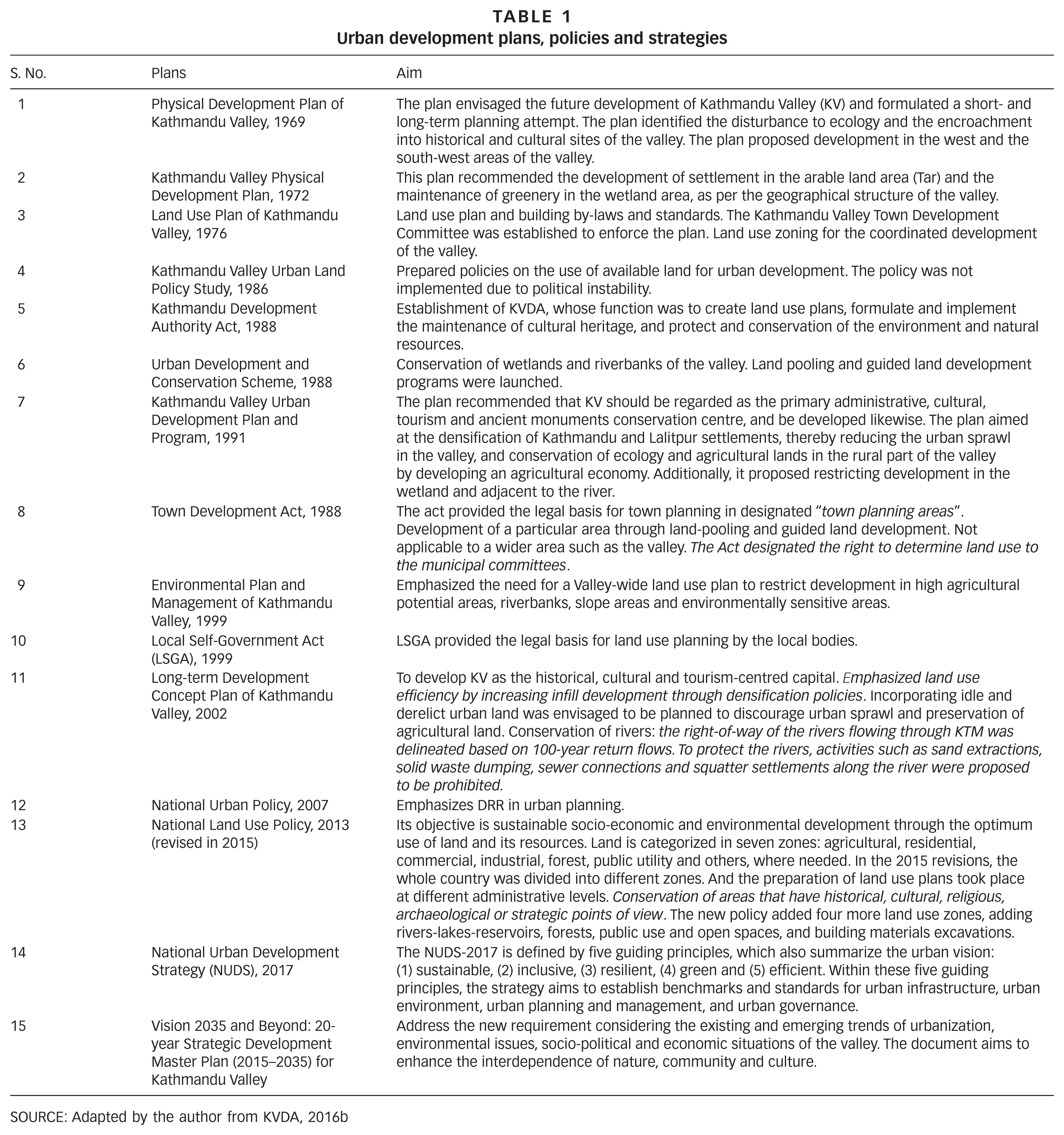
SOURCE: Adapted by the author from KVDA, 2016b
In the past decade, there has been yet another significant reconfiguration of urban planning in the process. The end of Maoist insurgency and monarchy, the declaration of Nepal as a Federal Republic and the reinstatement of locally elected officials after nearly 20 years have introduced new actors, authorities and priorities into Kathmandu’s urban landscape. This political shift revived planning initiatives that had long stagnated. The Manahara Land Pooling Project,(33) for example, remained inactive for 13 years before being reactivated once municipalities regained elected leadership and operational autonomy.(34) Under the Local Government Operation Act(35) municipalities acquired extensive authority over land management, enabling them to reshape development trajectories according to local priorities.(36) The newly empowered municipal government in Kathmandu aims to reorganize land in its jurisdiction primarily through the lens of revenue generation. The conversion of agricultural land into serviceable real estate plots has become a central strategy for increasing municipal income. This shift is most visible in Kathmandu Metropolitan City’s (KMC’s) move to reclassify all land within its jurisdiction as non-agricultural. This trend is followed by neighbouring municipalities, where landowners resist agricultural zoning because of its lower market value.(37) Such practices have accelerated land commodification and land-use change that privilege urban expansion over socioecological considerations.(38) The riparian geography of the valley has become strategically positioned within the municipal development priorities. This has caused riparian squatter settlements to become more ‘visible’.
The riverbanks of the valley are a socioecological terrain. Kathmandu’s rivers are rainfed and seasonal. During winter, the river flow is reduced, which exposes broad stretches of land, while during the monsoon in summer, rain rapidly inundates these same areas. This cyclical expansion and contraction of the river has created an illusion of surplus land. The government land-pooling projects, which are mostly targeted at the riverbanks,(39) use this exposed land as an underutilized resource, particularly when seasonal flooding is minimized or disregarded. At the same time, the temporal availability of riverbank land has also attracted informal settlers seeking affordable housing in the valley. Post-2006 political transformation intensified these processes, contributing to the permanency of the previously ‘temporary’ settlements.
Recent legal and political developments have contributed to and complicated these dynamics. The new constitution enshrines the “right to shelter” as a fundamental right and supports this right for households that have resided in the same location for more than 20 years.(40) However, these protections do not formally extend to riparian zones, which are designated as protected areas. The constitutional shift has nonetheless strengthened the land-rights movements and emboldened long-term settlers. The result is a riparian landscape shaped by competing claims – municipalities mobilizing planning instruments to transform riverbanks into revenue-generating urban space through land management, and squatters asserting rights to remain through legal, political and material practices.
Together, these arrangements produce the contemporary conditions in which flood risk becomes entangled with urban development visions and the everyday strategies of those living on the riverbanks. Rather than a static backdrop, the riparian zones emerge as an active site where hydrological processes, planning policies, political transitions, aspirations for urban futures and struggles for place intersect. In the section below, we present our case study site on the banks of the Manahara River.
c. Fieldwork location: Pragatinagar Basti
Pragatinagar Basti, a riparian squatter settlement along the shifting banks of the Manahara River, illustrates how urban informality in the Kathmandu Valley is produced through relational forces that connect geomorphological processes, planning regimes and rural–urban migration. Rather than emerging at the margins of the city, the settlement has taken shape within the interstices of fluvial dynamism and the state’s attempt at territorialization. Between 1967 and 2009, the Manahara River gradually migrated away from its original channel, exposing tracts of land that fell outside formal cadastral mapping and land-governance systems.(41) These newly formed riverbank spaces – unmapped and, hence, unregulated and unclaimed within official land-formalization processes – have become sites of possibility for urban migrants seeking affordable housing in the valley. As elsewhere in the Kathmandu Valley, the emergence of riparian squatter settlements cannot be traced to a single cause. The settlements are relationally produced through various unfolding urban processes such as channel shifting, bureaucratic ambiguities over land governance and socioeconomic pressures experienced by the urban migrants. In this context, the riverbank emerges as a primary geography for urban living for urban migrants.(42)
Despite the organic expansion of the settlement over several years between the 1990s and now, the leaders of the settlement emphasize that it was established in February/March 2001. This formalization refers to the establishment of the first organization – Nepal Bhumihin Vywasthapan Sangh (Nepal Landless Management Association) – working for the rights of squatters. It started with 11 households, all of whom were members of the organization. Pragatinagar Basti has now expanded into the largest squatter settlement in the Kathmandu Valley, accommodating approximately 774 households in 2024. Its spatial extent now straddles the administrative boundary between KMC and Madhyapur Thimi Municipality (MTM), generating a fragmented jurisdictional landscape in which responsibilities for service provision, regulation and risk governance remain contested. Over two decades, the settlement has transformed materially from a cluster of temporary huts into a dense landscape of multistorey reinforced concrete (RCC) buildings, tin-roofed extensions and semi-permanent structures. This consolidation, however, coexists with an increasingly unstable physical environment. The Manohara River’s gradual reversion towards its former channel, coupled with upstream river-training works that have redirected floodwaters, has intensified seasonal inundation, particularly in areas where no protective embankments exist.
Within the settlement, vulnerability is unevenly distributed through the interaction of exposure and socioeconomic differentiation. Residents themselves have divided Pragatinagar Basti into four zones based on proximity to the river and flood frequency. Zones 1 and 2 are located closest to the river’s meandering edge and experience recurrent flooding, while Zones 3 and 4 are relatively less exposed. Housing typologies, from tarpaulin shelters to multistorey RCC structures, reflect differential access to employment, economic opportunities and future aspirations. The zoning of the settlement simultaneously maps flood risk and codifies vulnerability, marking certain residents as more vulnerable.
The everyday negotiations of the squatters with flood risk are entangled within the competing visions of urban development that seek to stabilize the riparian landscape towards a formalized urban function. Two planning initiatives are relevant here, both targeting the same riparian terrain occupied by the squatters: the federally driven Bagmati Action Plan (2024–2044),(43) which proposes a riverfront greenbelt and corridor road, and the Manahara Land Pooling Project, led by local governments. These projects aim to transform the riverbanks of the Bagmati River system, including its tributary, the Manahara, into spaces of ecological restoration and infrastructural expansion. Within this vision of a planned urban landscape, the informal settlements become encroachments that are incompatible with the desired future. Pragatinagar Basti hence faces recurring threats of eviction. State actors have intermittently deployed coercive measures to control the riparian land.(44) One such example is the forced closure of a Korean-funded school(45) and the partial demolition of the settlement by the KMC Office in August 2025.(46) These material and institutional pressures are reinforced by dominant social narratives that portray squatters as outsiders whose presence burdens urban infrastructure and degrades river ecologies.(47) Yet, the endurance and expansion of Pragatinagar Basti complicate such framings. The riverbanks function not merely as marginal or residual spaces, but as active socioecological assemblages where the riparian landscape is continually produced through fluvial shifts, occupied through planning ambiguities, consolidated through residents’ material practices, and contested through political struggle.
V. (Re)assembling Narratives of Risk
In this section, guided by field data, we identify three provisional actors whose contingent alignment assembles the riparian geography of the Kathmandu valley: (1) the urban planning milieu, including federal and municipal officials and planning experts; (2) the DRR regime, comprising technical experts and bureaucratic managers across scales; and (3) the residents of Pragatinagar Basti. These actors take form through their relations, intersecting with and reconfiguring one another through shifting material, institutional and discursive connections. Their encounter has generated multiple and sometimes unstable modes of territorialization, each mobilizing imaginaries, infrastructures and everyday practices to generate multiple articulations of flood risk. This perspective reveals that flood risk is an emergent effect that is continuously coproduced through situated, sociomaterial negotiations, governed by competing visions of urban future, and sustained by shifting alliances across policy, infrastructure, and informal living and politics.
a. Urban planning and riparian assemblages
Urban planning in the Kathmandu Valley has been unfolding less as a coherent system than as a set of ongoing practices through which urban spaces are made governable, negotiated and problematized. Planning does not precede urbanization so much as it follows, reacts to and attempts to recalibrate the effects of uneven urban expansion. This is most evident in the procedural works of land pooling, through which agricultural land is assembled, re-parcelled and infrastructurally serviced to enable its conversion into real estate.(48) As much of the valley has already been built up,(49) local governments, newly empowered through federal restructuring, have increasingly turned their attention to managing, reworking and claiming remaining spaces.
These processes of planning are not channelled through a single authoritative framework. Instead, they are enacted through the overlapping circulations of plans, policies and regulatory instruments, including the National Land Use Plan (2015), the National Urban Development Strategy (2017), the Kathmandu Valley Strategic Development Master Plan (2015–2035), and, more recently, the Bagmati Action Plan (2024–2044). Each of these instruments introduces classifications, priorities and temporalities, which are selectively mobilized, interpreted or ignored in practice.(50) Planning thus operates through continual layering and reactivation of documents rather than through their unified implementation.(51)
Within this processual field, riverbanks are repeatedly redefined through competing modes of intervention. The Kathmandu Valley Development Authority’s (KVDA’s) practices of risk zoning and restriction seek to stabilize the riparian land as hazardous and in need of control (see online Appendix 1 for the trajectory of urban planning development in Nepal and the multiple institutions involved).(52) The Bagmati Action Plan enacts the river and its tributaries as an ecological and cultural corridor through techniques of riverbank restoration and beautification.(53) At the municipal level, land pooling procedures translate river-adjacent land into real estate – mobilizing planning as a revenue-generating practice. The riparian geography thus takes shape through the convergence and interference of multiple planning practices, norms and material interventions, none of which operate in isolation.
The planning devices do not form a unified strategy; instead, they have competing visions. The Bagmati Action Plan and Manohara Land Pooling Project, discussed below, exemplify how urban futures, risk and territorial claims are not pre-established objectives but are emergent effects of these ongoing planning processes. Together, they show how riparian space is continually assembled through the practical work of planning: through land classification, infrastructural intervention and everyday negotiations rather than through the actualization of any singular urban vision.
Bagmati Action Plan
The Bagmati Action Plan (2009–2014; 2024–2044) operates less as a fixed blueprint than as an ongoing set of practices through which the Bagmati River and the tributaries in Kathmandu Valley are repeatedly reimagined, ordered and acted upon. River restoration within the Bagmati Action Plan is organized through processes of cultural revival that position the Bagmati Corridor as both an ecological asset and a site of civilizational heritage.(54) Through this framing, the river is continually produced as something that must be purified, recovered and protected to protect the valley’s civilization. Practices associated with ritual waste, solid-waste disposal, informal structures, hoarding boards and squatter settlements are not simply identified as problems but are actively considered as disturbances that threaten the river’s integrity.(55)
The work of problematization is carried out through conservation vocabularies such as “river restoration”, “right of way” and “ecological corridor”, which translate complex sociomaterial riverbank relations into governable categories. These terms do not merely describe the river: they actively reorder it by legitimizing certain interventions while rendering others untenable. As one former official of the High Powered Committee for Integrated Development of the Bagmati Civilization HPCIDBC explained, “The land belongs to the river”: a statement that performs a territorial claim by naturalizing displacement and recoding informal dwellers as encroachers rather than inhabitants.
Through these discourses, the Bagmati Action Plan redirects attention away from those living with flood exposure towards what must be secured: the river, heritage and a particular future urban form. Flood risk is thus reassembled as something generated by informal occupation rather than as a condition unevenly distributed through planning decisions, hydrological interventions and socioeconomic inequality. In this configuration, squatters are made legible not as residents at risk but as producers of risk, echoing dynamics associated with bourgeois environmentalism.(56)
Importantly, this assemblage is not only discursive but also materialized through selective interventions along the river. Despite ongoing contestation, stretches of the main river flowing through the valley have been transformed through the construction of pati (traditional resting houses), while in the Manahara watershed upstream of Pragatinagar Basti, riverbanks have been incrementally converted into small parks equipped with outdoor gym equipment and punctuated by minor temples. These interventions do not simply beautify the river: they enact a particular mode of occupation that aligns with the Bagmati Action Plan’s vision of orderly, cultural and recreational riverfronts, while simultaneously foreclosing informal dwelling. Even as thousands of people continue to live informally along the valley’s riverbanks,(57) the Bagmati Action Plan does not assemble mechanisms for meaningful resettlement. Instead, it relies on the moral and technical authority of ecological restoration to sustain the legitimacy of removal.
Manahara Land Pooling Project
The Manahara Land Pooling Project, first authorized in 2006 and reactivated following local elections in 2017, operates as another set of planning practices through which riparian land and flood risk are continually territorialized. Figure 3 shows the location of the planned Manahara Land Pooling Project within the Kathmandu Valley, denoted by the circled area on the map. At its inception, the land readjustment plan aimed to consolidate fragmented land in the riverbank into a planned residential development covering 90.2 hectares along the river.(33) Now enacted through the administrative coordination of KMC and MTM, 116 hectares are being developed retaining 8.5 per cent of the land for infrastructure (road and sewage), and 4 per cent for public space.
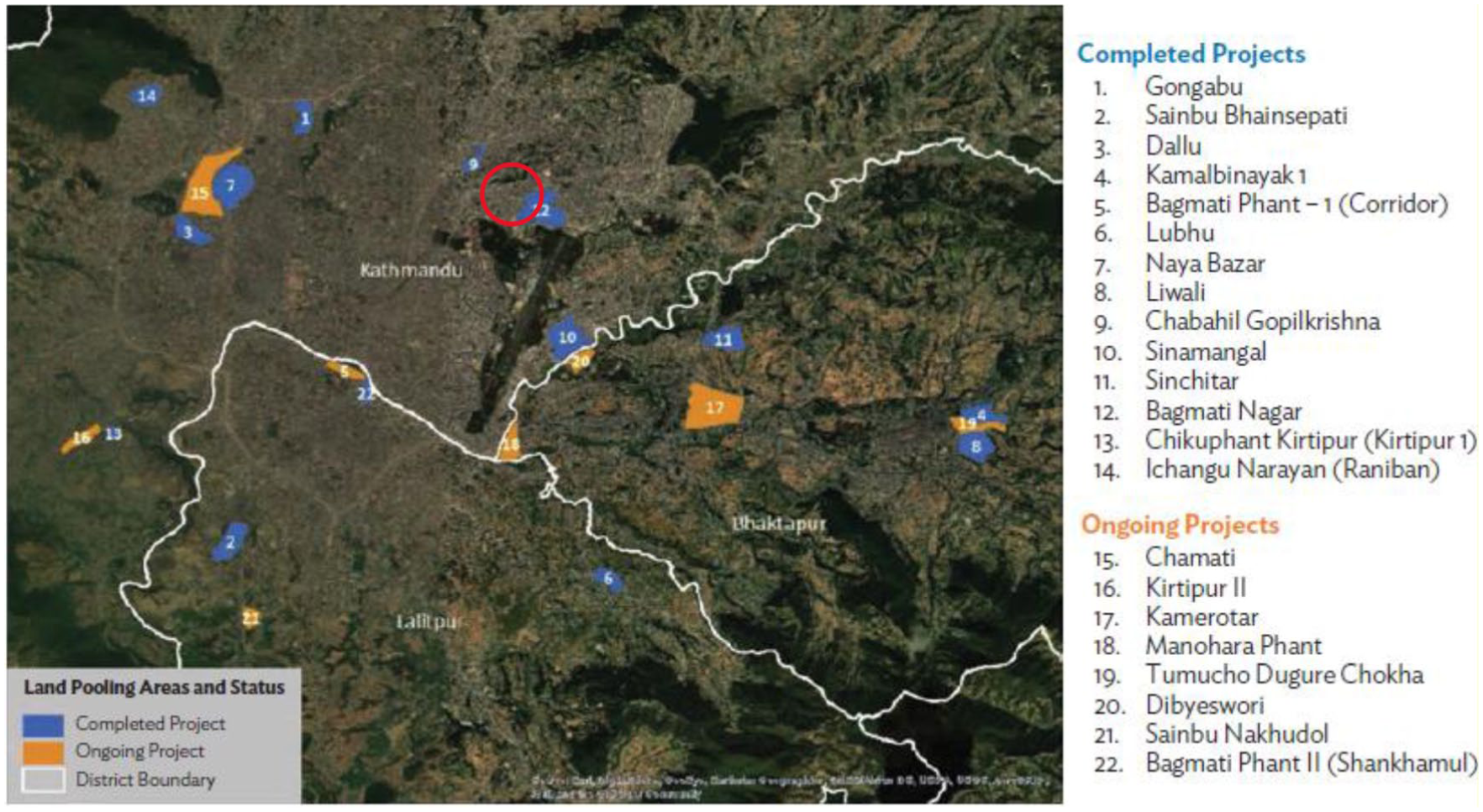
Land pooling project in the Kathmandu Valley.(58) The circled area in the map shows the planned Manahara Land Pooling Project
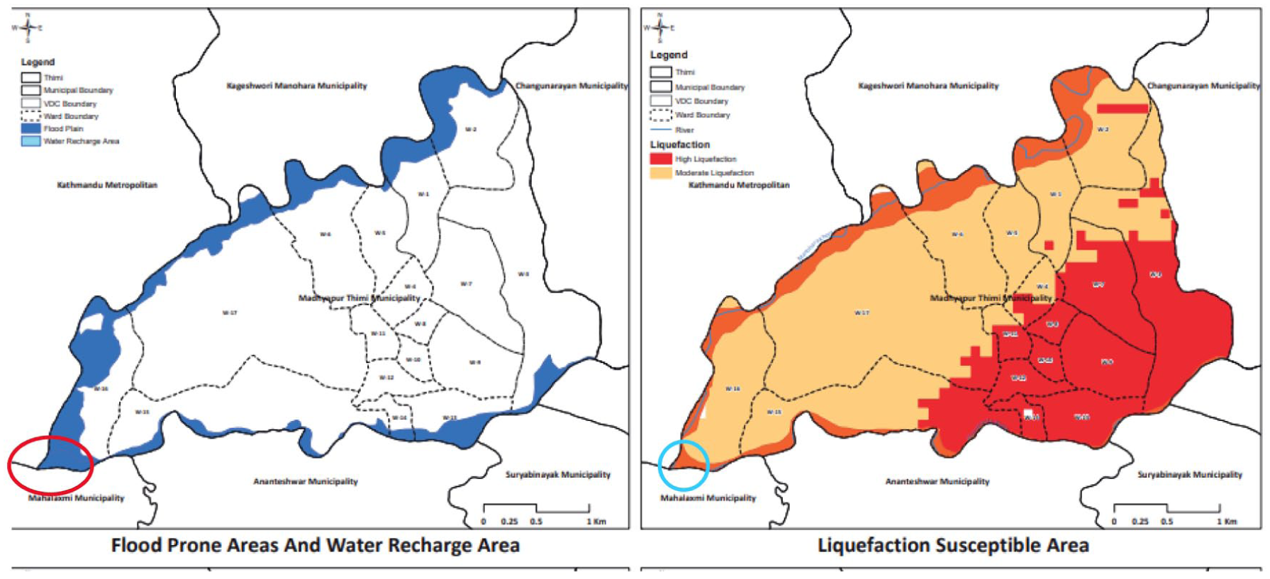
Inundation and liquefaction maps of Madhyapur Thimi municipality showing the location of the squatter settlements(60)
The project assembles legal documents, cadastral techniques, engineering surveys and political authority to render the Manahara Corridor legible as developable urban land. Central to this process is the repeated invocation of the river’s “original” channel, which the project’s detailed plan stabilizes as a technical reference point. The original channel is the space currently occupied by the squatter settlement.
Through this cartographic and bureaucratic manoeuvre, the river’s presumed proper course is mobilized as a tool for calibrating legitimacy. As the project manager noted, “The project cannot proceed unless the settlement is relocated”. This statement does not merely describe an obstacle; it performs a territorial operation in which the settlement is reconstituted as a technical impediment to development rather than as an inhabited space. Risk, in this configuration, is not addressed as lived exposure but is reassembled as a justification for clearing land to enable orderly urban form.
These planning processes are not confined to documents. Since the project’s revival, material interventions such as the construction of large boundary walls to demarcate future service plots have already begun to rework the river’s hydrology. Residents of Pragatinagar Basti describe how these walls – along with unmanaged mounds of excavated soil from land-pooling activities – redirected upstream flows and obstructed floodwater drainage, exacerbating monsoon flooding in 2022. When questioned about mitigation responsibilities, the project manager reiterated an exclusionary logic, asserting that “Squatters do not belong to Kathmandu”. This statement further reveals how belonging, risk and urban futures are assembled through planning practice.
Taken together, the Bagmati Action Plan and the Manahara Land Pooling Project show how flood risk in riparian settlements is continually assembled through planning practices rather than simply inherited from geomorphological conditions or past land-use patterns. Through the circulation of ecocultural restoration narratives and land-development rationalities, and through their partial materialization in walls, excavation mounds, greenbelts and redirected flows, these projects actively participate in the making of risk. Flood risk emerges here as a relational effect of intersecting territorial practices and governance techniques that seek to reorder the riverbank.
b. Disaster risk reduction and management (DRRM) assemblage
In July 2022, when floodwater entered houses in Zones 1 and 2 of Pragatinagar Basti, no early warning was issued, and no DRR officials visited the settlement until after the water had receded. Yet, on paper, the Manohara Corridor appears in the Risk Sensitive Land Use Plan (RSLUP) as a “high flood-risk” zone, and national DRRM policies identify floods as a priority hazard. This disjuncture illustrates that along the Manahara River, flood risk is not simply a technical parameter waiting to be recognized, but an effect of how DRR actors and devices assemble or fail to assemble in specific moments. In this section and next, we trace how risk is enacted through practices of mapping, categorization and selective non-recognition across three contexts: (1) the production and sidelining of RSLUP classifications; (2) the National Disaster Risk Reduction and Management Authority’s (NDRRMA’s) demand-based technical node; and (3) enacting and disqualifying risk on the Manahara riverbanks, which portray squatters as producers rather than subjects of risk.
From DRRM policies to practices of non-recognition
The constitutional and legislative architecture for DRR in Nepal, established through the Constitution (2015) and the DRRM Act (2017), does not fix risk as a stable object but enables particular ways of producing and acting upon it. While these instruments assign responsibility for protecting life and property, they leave risk itself loosely specified, implicitly aligning it with the “hazard=exposure*vulnerability” logic of the Sendai Framework.(59) In practice, this legislative openness allows risk to be variously enacted through technical devices, institutional priorities and political calculations. Preparedness, emergency response and large-scale disaster coordination are foregrounded, while localized and seasonal disasters, such as monsoon flooding along riparian corridors, remain weakly prioritized.
Within this governance landscape, risk-sensitive planning tools such as the RSLUP actively participate in assembling future urban geographies. The production of RSLUP maps involves hydrological modelling, hazard classification and zoning exercises that code the Manohara Corridor as “high-risk”. These maps do more than describe flood exposure: they express a particular urban future by rendering river-adjacent land legible as unsuitable for habitation and implicitly available for clearance, buffering or ecological conversion. High-risk zoning thus works as a territorializing practice that anticipates outcomes such as eviction, greenbelts or corridor development, while foreclosing alternatives such as in situ protection or upgrading of riparian settlements.
Yet, these mappings do not stabilize risk governance. Following decentralization under the Local Governance Operation Act (2017), municipalities acquired formal authority over risk reduction while simultaneously pursuing development strategies oriented towards revenue generation. In this context, the RSLUP classifications are not consistently acted upon but are selectively sidelined when they interfere with land-pooling projects and real-estate ambitions pursued by municipalities and the KVDA. Risk maps circulate within planning assemblages, but their force is contingent: they are activated to legitimize clearance and restriction, and muted when they threaten the conversion of land into serviced plots.
Two interrelated dynamics emerge. First, DRR governance operates as a fluid and internally differentiated assemblage in which risk is continually produced, translated and deferred through shifting alignments and deployment of maps, policies and municipal priorities. Second, riparian spaces where formal and informal land claims intersect are repeatedly designated as “high risk” yet remain sites of institutional suspension rather than protection.
NDRRMA’s demand-based technical support
The NDRRMA occupies a central position within Nepal’s disaster governance assemblage, coordinating resources, issuing technical guidance and supporting risk-reduction interventions. Yet, this centrality does not translate into direct action. NDRRMA’s involvement is activated only through municipal demand, positioning the authority not as a proactive guarantor of protection but as a responsive node whose capacities are contingent on local requests. NDRRMA officials described their role as “demand-based” and their technical engagements are oriented primarily towards infrastructural interventions and early-warning systems along major rivers, rather than towards recurrent, localized flooding in informal riparian settlements. As the head of the hydrology department noted, “The big municipalities within the Kathmandu Valley do not need our technical help; they have their own human resources”.
This demand-based mode of operation reveals how flood risk must first be recognized and articulated at the municipal level to circulate within DRR practice. When asked about recurrent flooding in Pragatinagar Basti, NDRRMA officials framed the issue not as a technical omission but as a political condition: without municipal initiative, the authority cannot intervene. In this process, although flood risk is technically classified in RSLUP and DRR policy documents, it does not automatically translate into action. Instead, it remains latent unless it aligns with municipal priorities and recognitional logics. Where municipalities decline to acknowledge riparian settlers as legitimate urban subjects, risk fails to register as a governable concern. Non-intervention is not the absence of risk governance but one of its modes, produced through the alignment of NDRRMA’s demand-based modus operandi, revenue-oriented municipal agendas and exclusionary notions of urban belonging.
Across DRRM governance institutions and policies, flood risk becomes an emergent outcome of exclusionary governance. Officials’ refusal to recognize squatters as legitimate urban citizens produces a situation in which recurring floods remain unaddressed, not because risk is unknown, but because it is disqualified. Through these practices, DRR governance territorializes who counts as ‘protectable’. The ‘risk’ experienced by the riparian squatter communities is therefore inseparable from the urban, political and social processes that shape the riverbanks, illustrating how DRRM governance operates within an assemblage in which risk exposure and mitigation are provisional and relational.
c. Squatters on the Manahara riverbank
Assembling flood risk
“In monsoon we fear the river, and in winter we fear the mayor.”
This often-repeated phrase in Pragatinagar Basti condenses the double hazard that organizes everyday life on the Manohara’s edge. For riparian squatters, flood risk and eviction risk do not appear as separate, sequential threats but as interwoven forces that continually rework how people dwell on the riverbank. In this section, we trace how residents actively assemble flood risk within a shifting terrain of informality, land claims and municipal contestation. Rather than treating the river or the state as stable sources of danger, we show how risk emerges from entanglements among material infrastructures (tin roofs, RCC houses, sandbags), hydrological rhythms (monsoon pulses, ‘big floods’), political pressures (threats of removal, jurisdictional ambiguities) and everyday strategies of adaptation and brokerage. Through these practices, the riparian settlement becomes a site where risk is not simply endured but continuously made and unmade.
Within the squatter settlement, flood risk is neither uniformly experienced nor uniformly articulated. The Manohara’s biophysical processes, like its seasonal rhythms, shifting channels, sediment loads and episodic surges, shape not only patterns of inundation but also how exposure is interpreted, narrated and politically coded. In early conversations in this fieldwork, many residents described the river as “gentle”, even benign, a characterization that appears at odds with the repeated inundations documented in 2021, 2022 and 2023. This discrepancy does not reflect a misreading of hazard; rather, it reveals how the river’s variable behaviour enables different stabilizations of risk at different moments.
During years of slow, predictable flooding, the river’s gradual rise and retreat support practices of adaptation such as raised plinths, movable belongings and seasonal adjustments that render inundation manageable and normalized. Under these conditions, exposure is lived but not named as a risk. The biophysical regularity of the river allows residents to code the riverbank as habitable space rather than as a danger zone. As one resident explained, “If we go to the government asking for help, they will tell us to leave [. . .] they will use the flood as an excuse to move us”. Here, the downplaying of flood risk becomes a political practice that works alongside the river’s seasonal rhythms to territorialize the riverbank as home.
At the same time, the river’s uneven geomorphology produces differentiated exposure within the settlement. Proximity to the channel, microtopography and the presence or absence of informal embankments mean that floodwaters arrive with different depths, speeds and durations across the settlement. Residents’ narratives of flooding vary accordingly. For households in less exposed zones, annual inundation is framed as a temporary inconvenience. For those closest to the river’s edge, flooding demands continuous adaptation such as stacking sandbags, raising thresholds, relocating valuables to higher shelves, or temporarily leaving the settlement altogether. In this way, the river’s material processes generate a spatial differentiation of exposure that is mirrored in how risk is remembered, narrated and anticipated.
Extreme flood events disrupt these settled relations. The larger floods of 2021 and 2022 exceeded the river’s familiar patterns, overwhelming existing adaptations and unsettling the coding of the river as “manageable”. Such events have left behind material traces such as water marks on walls and damaged foundations, as well as affective imprints that reorganize relations between bodies, houses and water. As one woman recalled, pointing to a high watermark on her wall, “In twenty years, I have never seen the river go mad like that”. These moments recalibrate local knowledge, not by revealing an underlying, pre-existing risk, but by reassembling it. The river’s biophysical excess interrupts squatters’ future-in-the-making and forces new interpretations, practices and claims. As one resident remarked, “This squatter settlement should be bulldozed, who remain in the settlement are real squatters [. . .] and only then will our problems get real solutions.”
Concrete territorialization
The aftermath of the major floods triggered noticeable material transformations in Pragatinagar Basti. Historically, the threat of eviction discouraged investment in durable housing, producing a landscape of tin, tarps and mud homes. After the destruction of eight houses in 2021 and 2022, residents began constructing RCC houses. One interviewee explained, “This house saved our lives [. . .] we were like on an island during the flood”.
These new structures are not merely protective. They also work as political artefacts of resistance against eviction: material claims to permanence that challenge municipal narratives of illegitimacy. In Grove’s terms, they demonstrate how communities shape their own risk ecologies by fixing certain relations(61) (durable houses, raised foundations) while destabilizing others (the notion of being temporary or removable). Concrete becomes a territorializing force, asserting belonging despite legal precarity. These new constructions, however, do not reflect compliance with building codes or state-led DRR guidance. Rather, they emerge from everyday experimentation: modifying structures, responding to recent floods, and recalibrating the balance between eviction risk and flood risk. Through these practices, flood risk becomes a medium through which political belonging is asserted, and the settlement itself is materially reassembled.
Risk in informality
In Pragatinagar Basti, informality is itself a constitutive element of risk. As municipal officials frame the settlement as “encroachment” and the absence of formal tenure constrains the residents from accessing municipal services, which also includes any kind of DRR management support. But informality is not a singular condition; it is fragmented, negotiated and contested. Informal spaces are governed by local committees and informal brokers, who mediate land access and resources within such settlements. Households with stronger social networks or financial means navigate this arrangement, while others remain exposed, as expressed by a single mother who described how informal governance intensified her precarity during post-2022 flood reconstruction: “He didn’t get his cut in the land transaction, so he tried to demolish my hut.” In her account, “he” refers to a local committee member, and it shows how risk is assembled not only by the state but also by internal settlement politics, opaque land dealings and the absence of legal frameworks for squatting. These interactions create nested forms of insecurity – social, economic and hydrological – each shaping how residents anticipate and respond to future events.
Life on the riverbank is shaped by the continuous reworking of relations among river flows, municipal decisions, advocacy networks, land-use policies, settlement morphologies and everyday survival strategies. The riparian settlement is not a passive site of vulnerability but an active field of world-making. Residents are not merely at risk; they are coproducers of the assemblages through which risk becomes knowable and politically meaningful.
VI. Flood Risk as a Future-Making Strategy
The case of Pragatinagar Basti shows that along Kathmandu’s riparian margins, flood risk operates less as a measurable condition to be managed than as a medium through which different actors seek to make particular urban futures real. “Risk” here does not precede the practices of planners, DRRM officials and riparian residents; it is continuously brought into being as these actors narrate the riverbank, circulate maps and models, build and demolish structures, and anticipate monsoon seasons and possible evictions. In this sense, flood risk is a future-making strategy: a way of composing and contesting what forms of dwelling will be possible, legitimate and durable. Drawing on Anderson and McFarlane’s notion of composition,(62) the Pragatinagar Basti assemblage shows how heterogeneous elements and plans – such as the Bagmati Action Plan and Manahara Land Pooling, DRRM procedures, RCC houses, hydrological flows and temporal imaginaries of clearance, permanence or displacement – come together to produce contingent distributions of security and exposure.
Urban planning interventions such as the Bagmati Action Plan and Manahara Land Pooling articulate visions of ecological restoration, heritage enhancement and metropolitan order. These promissory futures are stabilized through the strategic mobilization of flood risk: planners narrate the riverbank as dangerous and environmentally fragile, a space that must be cleared of informal settlements to realize an imagined ‘green’ and an ordered urban future. Making the riverbank legible as a dangerous, fragile space is precisely what allows the displacement of squatters to appear as environmental restoration rather than social violence. Hence, risk functions as a technology of territorialization, a means through which specific urban futures become actionable and legitimate, echoing Zeiderman’s argument that governing risk is fundamentally about governing uncertain futures.(63)
Yet, risk is assembled differently in the DRRM regime. Recurrent flooding in Pragatinagar Basti remains largely invisible within institutional assessments. Technical framings of risk derived from hydrological models, hazard maps and national guidelines produce exclusions that render riparian settlers absent from official future-oriented planning. Hazard is thus simultaneously invoked (as justification for eviction) and disavowed (in DRRM systems), revealing risk to be a selective and unevenly distributed effect of governance. This selective visibility points to the ways institutional practices themselves contribute to the composition of risk, shaping who is recognized, who remains peripheral and whose futures are planned for.
Squatter residents participate in this assemblage not merely as recipients of risk but as active agents shaping the territorial future of the riparian landscape. Residents downplay flood narratives to fortify their territorial claims while simultaneously enacting material adaptations for flooding, such as sandbagging, raising plinths and, more recently, building RCC houses. Rather than a contradiction, this ‘strategic ambivalence’ illustrates how risk becomes a situated resource, enabling residents to navigate the political, legal and material uncertainties of informal living. In Grove’s terms,(64) these practices reveal anticipatory life in conditions of precarity, where futures are not projected through formal planning but improvised through everyday negotiations and infrastructural interventions. The growing presence of RCC houses exemplifies this dynamic. These structures materialize a particular future-in-the-making, the desire for permanence and formal recognition. However, these practices simultaneously generate new vulnerabilities. As residents adapt to the recurring flood, the riverbank becomes a site where risk and resilience coproduce one another. RCC construction mitigates flooding and inundation yet exposes households to liquefaction hazards and seismic risks, aligning with McGowran and Donovan’s notion of “disaster-in-the-making”.(65) In Pragatinagar Basti, the dynamics of disaster-in-the-making do not just emerge from maladaptation to floods. Various factors, such as governance ambiguities, seismic geology and household aspirations for urban living, all contribute to a possible future of harm.
In Pragatinagar Basti, flood risk does not exist prior to intervention; it emerges through action. Risk is produced and continuously reassembled through the contingent entanglements of hydrological flows, planning and land-use policies, political negotiations, informal economies, construction practices and future-oriented imaginaries. It is not a static condition but a relational effect that manifests differently across the practices of multiple actors.
VII. Conclusion
Framing flood risk as an emergent assemblage illuminates its inherently relational, contingent and future-oriented character. Risk is not simply a measure of hazard; it is a lens through which certain urban futures are made legible, actionable and sustainable, while others – such as the in situ protection of informal settlers – are rendered untenable. The Pragatinagar Basti case, therefore, demonstrates that urban risk governance is a politics of future-making: it operates not only to respond to environmental contingencies but also to selectively assemble the city, shaping whose lives, lands and infrastructures are recognized, protected or displaced. It highlights the need to consider risk governance as a dynamic and contested process in which exposure, knowledge and authority coproduce the possibilities and limits of urban life.
Supplemental Material
sj-docx-1-eau-10.1177_09562478261423925 – Supplemental material for Reassembling narratives of risk in the urban margins
Supplemental material, sj-docx-1-eau-10.1177_09562478261423925 for Reassembling narratives of risk in the urban margins by Rachana Upadhyaya and Alejandro Barcena in Environment & Urbanization
Footnotes
Supplemental Material
Supplemental material for this article is available online.
4.
14.
15.
17.
Whatmore (2002, ![]() ).
).
33.
The Manohara Land Pooling Project is an urban land readjustment initiative that reorganizes fragmented private land along the Manohara River into a planned residential area. The process brings together fragmented plots from multiple landowners, consolidates them into a single area, reorganizes the land through previously agreed upon subdivision, and redistributes the serviced plots to the original owners. Part of the land is reserved for hard infrastructure, as well as for social facilities such as schools, government buildings and public amenities such as parks and open spaces (![]() ).
).
39.
See note 33.
48.
53.
59.
UNDRR (2015, ![]() ).
).
60.
Kathmandu Valley Development Authority (2016).
References
Supplementary Material
Please find the following supplemental material available below.
For Open Access articles published under a Creative Commons License, all supplemental material carries the same license as the article it is associated with.
For non-Open Access articles published, all supplemental material carries a non-exclusive license, and permission requests for re-use of supplemental material or any part of supplemental material shall be sent directly to the copyright owner as specified in the copyright notice associated with the article.