
Abstract
This paper describes recent urban transformations in flood-prone areas on the outskirts of Buenos Aires that, prompted by a convergence of public–private interests, ignore the adverse consequences they generate and produce deeply unequal exposure to disaster risks. To illustrate these processes and their spatial results, the paper looks at the case of the municipality of Tigre, located to the north of the metropolis. I analyse the most substantive changes in public urban management and implementation of water management projects that have tended over recent decades to facilitate the operation of real estate/financial capital, through the development of degraded flood-prone risk areas that has made these the subject of dispute between antagonistic social groups.
I. Introduction
So-called “natural” disasters are among the most notable environmental problems facing today’s urban societies. The transformations occurring in cities over recent decades are very important to an understanding of why those disasters happen. Recent urban changes have direct consequences in terms of both social vulnerability for the population and the extreme natural conditions found in the floodplains, unstable slopes, coasts at risk from hurricanes, and other areas that are increasingly becoming urbanized.(1) As a result, cities and the changes they are undergoing are key to understanding the “new disaster risk scenario”.(2)
Studies of disasters have focused their analysis on the most vulnerable social groups and the processes of marginalization that drive them against their will into occupying areas with extreme natural physical/natural conditions, in order to be part of the city. Nevertheless, in certain circumstances, these same areas may be the target of urban development for the benefit of the most well-off groups. We then see a tendency in which the production of disaster risk spaces is more unequal, while at the same time these areas with extreme natural conditions are disputed by social actors/groups at opposite ends of the spectrum in terms of vulnerability and their position in power relations. Academic research has barely touched on the production of spaces of disaster risk by and for the most powerful groups in society, so more work is required to move our understanding forward.
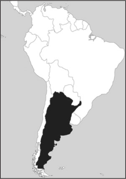
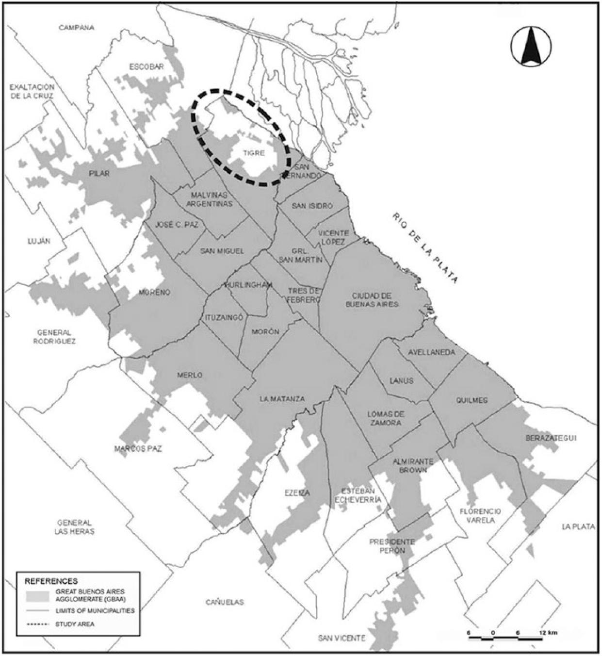
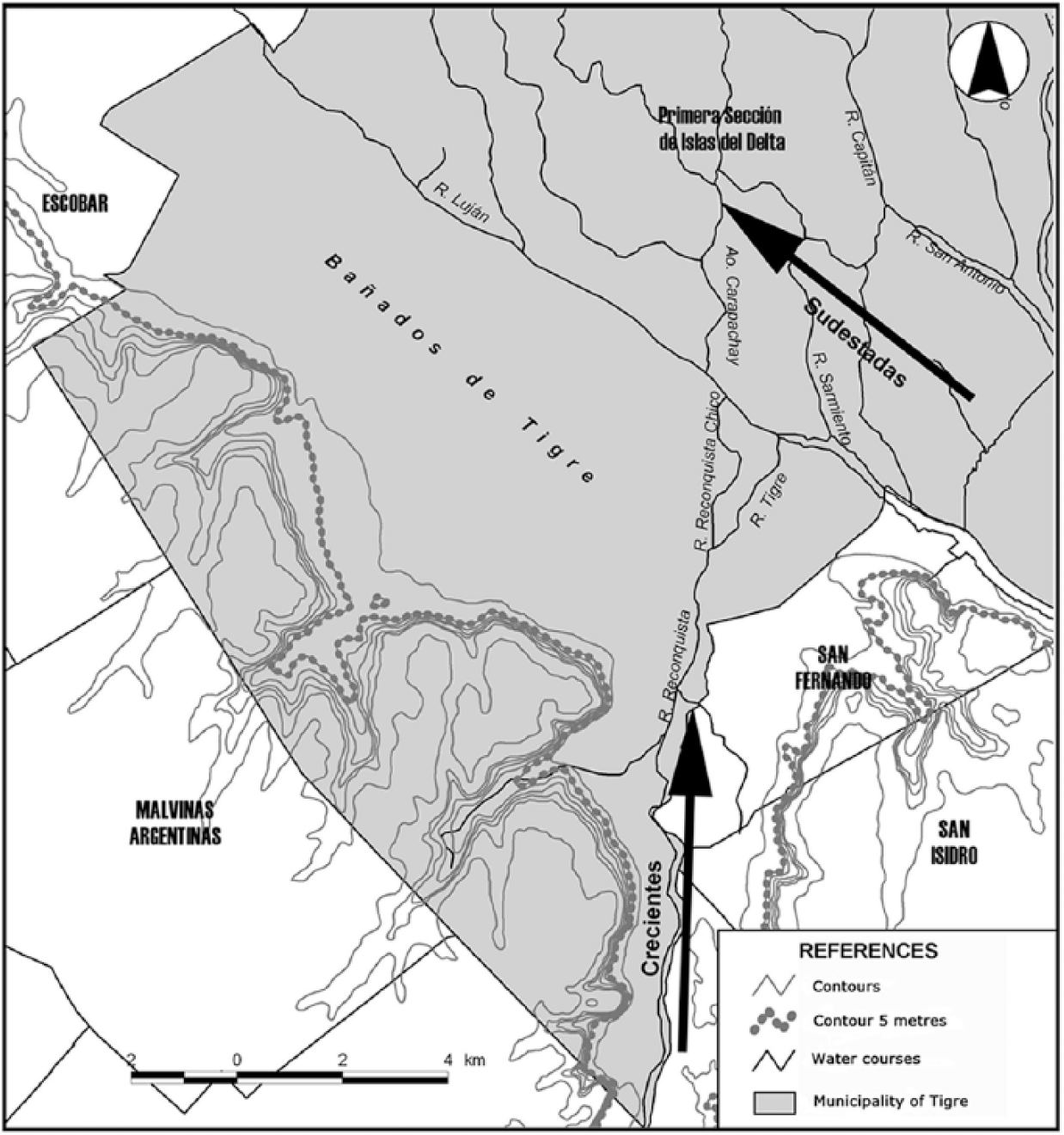
The Great Buenos Aires Agglomerate (GBAA) faces the kinds of problems mentioned above. Over the last few decades, urban restructuring processes have taken place in the flood-prone areas that in the recent past have rarely been viewed positively. The municipality of Tigre (Figure 1A and Figure 1B) is one of the most emblematic cases, due to the remarkable suburban expansion spearheaded by gated communities on large landfill sites on the ample vacant floodplains in the mainland area of its territory. These wetlands, known locally as bañados, include a fringe extending between the Luján River and the ravine, with a contour of 5 metres above sea level (Instituto Geográfico Nacional – IGN). Floods occur there as a result of different causes: a) storm surge floods (known locally as sudestadas) preventing the normal run-off of the waters of the Plate River and raising its level; b) intense rainfall causing the rivers and streams (e.g. the Reconquista River) that cross the bañados to burst their banks; and c) the less likely combination of these two causes.
Location of Tigre in Buenos Aires
Study area in the Tigre municipality
This paper seeks to shed light on the recent urban transformations of flood-prone areas in the municipality of Tigre that reflect the present stage of capitalist urbanization, stressing the role played by entrepreneurial public urban policies and investment in public works (especially water management) in the uneven production of disaster risk spaces. In short, it seeks to contribute to discussions in the environmental field of social sciences where the relationship between cities, disaster risk and society is being studied. To achieve this objective, the work has drawn on secondary sources (specialist works, official documents, cartography, water management projects, etc.).
II. Some Theoretical Considerations(3)
Some decades ago, the social sciences ceased trying to find the explanations for “natural” disasters in extreme natural phenomena. Instead, the focus was on the ways in which societies are organized and establish their relationship with nature, especially following the logic imposed upon them by the capitalist mode of production. Since the 1970s, the political economy approach to disasters has shifted the focus towards “taking the naturalness out of natural disasters”,(4) although this does not imply, as suggested by Smith,(5) denying the natural processes that form part of them.
The political economy approach looks at these problems less in terms of the spectacular nature of the results (the time of the disaster), delving instead into the processes that generate the material conditions for their occurrence (the risk or disaster risk).(6) To understand the material conditions of risk, this school of thought focuses on social vulnerability, i.e. the social, economic, cultural and political circumstances of a society (or part of that society) existing prior to the occurrence of the disaster. These conditions define the differential capacity of the society and the groups within it to anticipate, resist and recover in the face of exposure to a threat or danger.(7)
In speaking of marginalization, the political economy approach also highlights the way that social inequalities limit the life options of socially vulnerable groups, forcing them to occupy degraded, hazardous environments, while restricting their ability to cope with environmental changes such as disasters.(8) A great deal of the research undertaken using the political economy approach focuses on the processes of marginalization linked to the risk; there is very little work tackling the formation of risk by better-off social actors/groups.
However, in particular historical frameworks, some features of the natural conditions (elements and processes) present in areas where extreme natural phenomena occur can be seen in a positive light.(9) Against a background of wider dissemination of environmentalist values in the last few decades and the conversion of natural assets into “new rarities”,(10) especially in urban areas, some extreme natural conditions are gradually being transformed into resources and saleable goods for consumption. Nature, as Smith reminds us,(11) has been an essential element in capital accumulation, but in recent decades has turned into a much more intense and global accumulation strategy.
Private economic stakeholders linked to the property business through advertising and marketing have made the need to “live in contact with nature” into an indispensable element of achieving a “better quality of life”. More and more emphasis is placed on the need to consume green spaces, taking a course backed by a heavily ideology-laden discourse.(12) The search for unique views or landscapes, as well as the use of and access to bodies of water and areas with leafy vegetation, associated with the development of exclusive property products set up by private economic operators, is increasingly set against the urbanization of areas where extreme natural phenomena occur.
One may wonder why, in urbanizing these areas, capital should put itself at risk, given that in the process it is building a disaster risk space. This can be explained by the key role that urbanization plays for capitalism. As Lefebvre notes (cited in Harvey),(13) “capitalism has to urbanize in order to reproduce itself”; this tendency has increased considerably since the crisis in the 1970s and the emergence of the neoliberal phase. Since then, “real estate” has formed part of one of the crucial sectors of capitalism insofar as it has been absorbed by financial capital.(14)
Capital is urbanizing again in new forms through real estate/financial investments that have unleashed the processes of urban renewal and expansion in various cities of the world. This has enabled a greater and quicker yield on the circulation of that capital, which has a growing need to reproduce itself.(15) Furthermore, this real estate/financial investment linkage has meant the emergence of a series of specific spatial forms, which authors such as de Mattos(16) call “representative artefacts of globalization” and which include corporate buildings, luxury hotels, hypermarkets and gated communities.
For the capital cycle to continue, there must be an alliance with political power, expressed when it comes to urban matters in public policy that tends to favour groups with greater economic power.(17) Specifically, urban policies have undergone profound changes in recent years as regards management, especially the emergence of new forms of what Harvey(18) calls “entrepreneurial” urban management and planning. This is happening against a background of increasing inter-urban competition in the interest of attracting greater property/financial investment. Since the 1970s, coalitions have been formed among government authorities (at different levels of operation), civil society organizations and private economic operators to administer urban development and especially to foster the processes of urban renewal and expansion.(19) In this way, as Harvey maintains, “in the contemporary neoliberal environment, the power to direct the social surplus managed by the State has been captured by the capitalist elites”.(20)
When better-positioned social actors/groups get involved in the process of urbanization of areas where extreme natural phenomena occur, the interplay of the market and the state often results in the latter acting as institutional facilitator. Research by Davis,(21) Steinberg,(22) Collins,(23) and Greenberg and Fox Gotham(24) shows how, in different states and cities of the United States, these social actors help the dominant groups to minimize the negative “externalities” present in those areas, while they foster the appropriation of the positive “externalities”. In the case of urbanization of flood-prone areas, facilitation processes can move forward through adjustment of urban planning regulations, generation of tax incentives or investment in transport infrastructure, and especially water management works, among other things.
Those changes in the urban space, which imply incorporation of value by the public sector, enable private appropriation of profit (the differential rent obtained from this particular land) and communication as to the adverse consequences. Furthermore, as Lindón(25) reminds us, changing the condition of urban land brings about an alteration in the valuation of space that often ends up producing a change in the social hierarchy of those areas.
For example, in flood-prone areas, as demonstrated by Clichevsky(26) with regard to various cities in Argentina, it has been noted that water management work carried out by the state can lead to those devalued flood-prone areas occupied by low-income groups becoming areas valued and occupied by groups in better socioeconomic circumstances and also by capital-intensive productive activities. This process implies shifting less favoured groups, which, in general, end up having to move to other areas with worse environmental and service infrastructure conditions, thereby generating a change in land tenure in those areas.
Scientific knowledge of the relationship between processes of urbanization of flood-prone areas and implementation of water engineering projects, from the perspective of studies of disasters and risk, has come a long way. Both in the research undertaken in the 1940s by Gilbert White and his team in the United States and in the research undertaken as of the 1980s by specialists in Hispano-American topics,(27) it has been proven that water management techniques implemented to mitigate the adverse effects of sea level rise also form an important element of the management of disaster risk conditions. Specialists agree in the latter case that, as Gilbert White puts it,(28) there is a kind of “hydraulic paradox” in which the greater the investment and sophistication of the water management techniques, the greater the amount of property and number of people exposed. This is related to the feeling of “security” that is attributed to those works and investments, making up a kind of “environmental amnesia”(29) that generally leads to greater negative impacts when the disaster strikes.
On the basis of the above, I agree with Calderón(30) that, to understand disasters and risks, it is necessary to identify and analyse the ways in which our societies produce their spaces and, especially, the particular forms the process takes in capitalist societies. The production of space in that type of society is distinguished by its unequal development – or unequal geographical development in the words of Smith.(31) This spatial differentiation is based on the principle of division of labour, which means that the various social groups have differential access to the resources generated by society, and these are the factors that generate vulnerability for the members of those groups. In this way, people are put at risk because there has been a production of spaces that, depending on the level of vulnerability of the population that creates them, become unequally risky. That is, rather than being the same for everyone, the risk is more decisive for some groups than others. For this reason, some of the key questions that must be asked in order to understand these complex issues, according to Smith, are why, since when, with whom and how society, differentiated into groups, builds on spaces and puts them at risk. In short, I feel that from the perspective of geography, the explanation of this kind of problem will primarily be found in the processes involved in producing disaster risk spaces.
We shall see in the next section how the aspects and processes mentioned above are expressed in the case of the municipality of Tigre.
III. Tigre: A Profoundly Unequal Disaster Risk Space(32)
Over the last few decades, GBAA has seen a significant transformation of the processes of producing urban space, generated by the dynamics of real estate/financial capital at both local and global levels, as well as the development of government urban policies geared towards private interests. Despite the fact that the neoliberal phase of capitalism began in Argentina at the end of the 1970s with the last civilian–military coup, it was during the time of the Menem government at the end of the 1980s and early 1990s that the most significant foundations were laid for the benefit of private capital. Among the most notable of these are the administrative reform and deregulation of the economy driven by the central government through the State Reform and Economic Emergency Law of 1989 and the Convertibility Plan of 1991. Simultaneously, changes affected private economic actors, particularly those linked to international financial capital. This led, as maintained by Pírez,(33) to a change in the balance of power due to the greater economic power of these new social actors and their capacity to decide on the city’s configuration.
Those changes can be seen in the proliferation of a very large number of high-end high-rise buildings, hypermarkets, luxury hotels, gated communities and theme parks. On the periphery of GBAA these transformations occurred primarily in the areas crisscrossed by the metropolitan highway network, where the predominant process was suburban expansion aimed at the most well-off groups.(34)
The particular feature of Tigre is that the above-mentioned urban phenomena were more intense in the flood-prone areas of the mainland area of its territory. An important part of these transformations is rooted in changes in urban policy and the water management work carried out in those areas by the state at its respective management levels: the governments of the province of Buenos Aires and the municipality of Tigre in power over the last few decades.
As Baer(35) shows, the growth in the property market during the first decade of this century (especially in 2003 as the economy recovered) was primarily geared towards the building of high-end residential properties, reaffirming the long-standing process of property development of the whole northern zone of GBAA (from the district of Puerto Madero in Buenos Aires City up to the municipality of Tigre in the province of Buenos Aires). In this context, the municipality of Tigre stands out as the political/administrative unit on the outskirts of GBAA that has the most square metres of land with planning permission granted in the last decade: 1,570,000 m2 (a similar figure to that in Palermo District, an emblem of urban transformation for the centre of the metropolis). In Tigre, that quantity of square metres with planning permission corresponds to the building of more houses in the luxury and sumptuous categories, along with blocks of flats, primarily in gated communities.
The incorporation of the flood-prone areas of the municipality of Tigre into the urban conglomeration has followed a path through more than four centuries of history. Nevertheless, the urban transformations occurring in recent times bear witness to a radical turnaround and were driven in particular by one property product, the gated communities, and the use of a new technique to urbanize those areas: greater landfill (Photo 1).
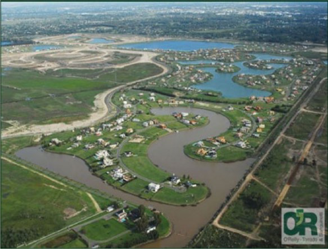
Gated communities on large landfill sites in Tigre
The technique of landfill involved the movement of huge volumes of earth, primarily obtained from the bañados (wetlands) themselves,(36) to serve as material to fill in the land where the developments were to be established. As a result of that process, a new topography was created in the bañados, where the average height of the landfill sites on which the gated communities stood reached 1.7 metres above the original height above sea level (Photo 2), in contrast to the un-reclaimed areas located outside. This new topography altered the dynamics of the water system of the bañados, as it eliminated one of the functions performed by wetlands (retaining surplus water), at the same time as it reconfigured the course of the tributaries of the Luján and Reconquista Rivers (such as the Guazunambí, Las Tunas and Basualdo Streams). In view of all these changes, it is thought that when a substantial rise in water level occurs in this intricate differential topography, the floods will be considerably faster and more damaging in the unfilled areas, with differential impacts on the most vulnerable groups living there.
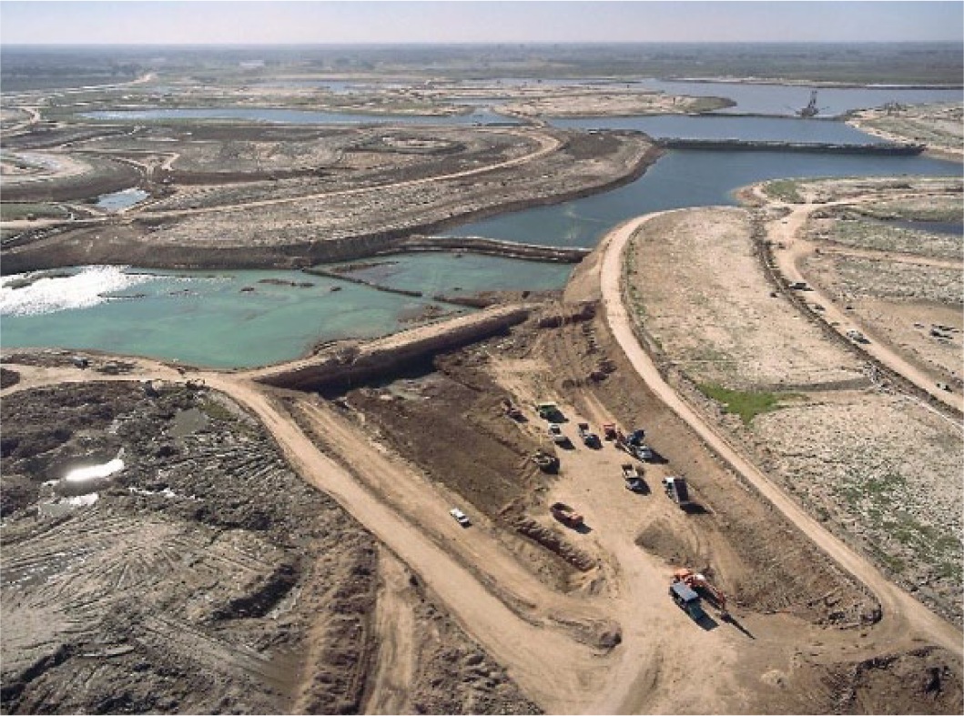
Construction of large landfill sites and the Central Nordelta Lake
Moreover, taking earth in order to reclaim the land resulted in the creation of other geographical features in the bañados: lakes, marinas and canals. These “aquatic” features have increasingly been transformed in recent times by the property market, serving to distinguish these gated suburban communities and enable greater profitability.(37) Landscape vistas where green spaces and water are combined (considering the recreational and sporting uses to which they can be put) are presented as an opportunity for a “better quality of life” in “contact with nature”, making the products offered by this property sub-market more and more attractive to consumers.
Given that the bañados in Tigre are extremely flood-prone, the technical transformation brought about by the water management work has marked a large part of the history of its urbanization. The Aliviador Canal(38) was built at the beginning of the 1970s, at the time of the rising of the Reconquista River, which had caused a large amount of flooding in the 1950s and the major flood of 1967. It crossed an inaccessible section of the bañado, raising the urban value of the nearby land.
Between the end of the 1970s and the early 1980s, when the military government was in power, a series of urban reforms was planned in the province of Buenos Aires as neoliberal policies gathered pace. The production of urban space for economic use that had characterized the previous stage (industrialization through import substitution) was halted, while private economic operators were favoured as large expanses of land were left to them and they were shown the most profitable property product aimed at better-off groups: country clubs. One of the most important of these reforms was Provincial Decree-Law No. 8912/77, the planning and land use regulation.(39)
At the end of the 1970s, the companies Supercemento and DYOPSA proposed a large-scale urban project (around 1,300 hectares) on land close to the Aliviador Canal, giving it the name Benavidez Integrated Urban Complex. For the first time, landfill was suggested as a construction technique to mitigate risk when seeking to urbanize this flood-prone area. Despite the fact that this project did not materialize during those years, primarily for financial reasons (it was finally implemented at the end of the 1990s under the name Nordelta with the incorporation of Consultatio S.A.), it did boost the urban value of that flood-prone area for developments aimed at better-off groups. This led to the emergence of the first gated communities in the Tigre bañados: the Boat Center country club in 1977/1978 and the Náutico Hacoaj country club in the 1980s.
With the return of democracy in December 1983, the poorest groups started to come back to the urban area of the Tigre bañados, resulting in the growth of informal settlements (as in other parts of the periphery of GBAA). Between the 1980 and 1991 population censuses, the proportion of residents in this kind of settlement relative to the total population of the municipality of Tigre increased by 60 per cent.(40) Moreover, in the crisis scenario of the 1980s, a series of floods played an important role, particularly as regards the most vulnerable communities. In that decade, there were seven episodes of flooding (caused by the rising of the Reconquista River and sudestadas), some of which had major adverse consequences, e.g. the flood of November 1989.
In response to the crisis created by such flooding, a very ambitious plan of water management work, the Reconquista River environmental clean-up and flood control project, was carried out in the Reconquista River Basin, under the responsibility of an autonomous provincial entity (UNIREC) with funding from international credit institutions. This water management work again enhanced the value of land in the bañados, at the same time as it reinforced the idea of a “final solution to the problem”, a situation that coincided with two decades that saw few extreme events.(41) This generated a kind of “environmental amnesia” with regard to flooding and an inappropriate perception of a final solution in the area.(42)
At the beginning of the 1990s, around 50 per cent of the territory of the municipality of Tigre (formed by almost 5,000 hectares of flood-prone areas) was “vacant”. There were large expanses of land not being put to productive use by their owners while other sections were being used for horticulture or forestry, hosted decaying clubs/trade union recreation centres or were occupied by informal settlements. During those years, the poorest groups exerted strong pressure to move into those properties (usually under private ownership) through occupying land. In addition, at the start of that decade, real estate/financial capital interests saw the opportunity to make a profit through urbanization of this vacant flood-prone area, turning gated communities on landfill sites into a means and an end to reproduce that capital. From then on, land in the bañados was hotly disputed by antagonistic social actors and groups.
In the early 1990s, under the leadership of the accountant Ricardo Ubieto (mayor of the municipality from 1987 to 2006),(43) the local government felt that the future direction of Tigre depended on the disputed territory of the bañados, according to which the strategies adopted by various sets of social actors/groups were to be supported. On the one hand, encouraging the development of gated communities on landfill sites would help to push the socioeconomic level of their residents upwards and thereby copy other municipalities in the northern part of the metropolitan periphery, as well as to attract private investment in other sectors. On the other hand, from that perspective, if no action were taken to restrict the expansion of the informal settlements, the municipal authorities foresaw that a “huge shantytown”(44) would form in the bañados, causing Tigre to resemble many other municipalities located in the second and third rings of the periphery of GBAA.
Seeing the interest of private economic actors in land in the bañados, the municipal government adopted an entrepreneurial urban policy at the beginning of the 1990s in which gated communities on landfill sites began to represent the primary “urban development model” proposed for the extensive flood-prone areas. Strategies were prepared by the local authorities to facilitate greater “flexibility” in urban legislation (especially the Tigre District Zoning Code, Ordinance No. 1894/96), speed up the procedures for administrative approval of proposed gated communities, and undertake public investments of great benefit to those private entrepreneurial groups, with a view to making the territory more attractive. The more notable public investments included work to improve the city’s appearance (turning Paseo Victorica into a park and inaugurating the Tigre Museum of Art) and work on transport infrastructure (widening and repaving Road Number 27 and building the new Tigre River terminal).
Over the last two decades, there has been a considerable increase in the quantity of, and area occupied by, gated communities on landfill sites in the bañados of Tigre, from two developments and an occupied area of 202 hectares in 1991 to around 50 and an occupied area of 4,035 hectares in 2010. In the case of the informal settlements, increases in quantity and area were noticeably lower: in 1991, there were 14 informal settlements occupying an area of 140 hectares, whereas in 2010 there were 21 informal settlements occupying an area of 221 hectares. These figures illustrate who “won the match” and ended up getting hold of the bulk of the land in those flood-prone areas.
The business of building gated communities on landfill sites was initially controlled by construction companies (Supercemento–DYOPSA and Pentamar SA), which were in a position, due to their know-how and the existence of dredge ports in the area, to save on costs. However, that business very soon ended up in the hands of development companies linked to financial capital. Consultatio S.A.,(45) headed by Eduardo Constantini, was the vehicle through which volatile financial capital got hold of the greater share of Nordelta SA (which previously belonged solely to the Supercemento–DYOPSA group). For its part, Emprendimientos Inmobiliarios de Interés Común (EIDICO), owned by the Lanusse family, was responsible for a large number of gated communities on landfill sites in the Tigre bañados through the mechanism of trusts,(46) which enabled them to inject capital from consumers and renters. It should be pointed out that these two business groups hold more than 72 per cent of the urbanized land involved in gated communities in the Tigre bañados and, together with their original partners (Pentamar SA and Supercemento–DYOPSA, linked to capital in the construction and associated services sector), are becoming the principal “masters” and managers of the new urban forms being adopted by the so-called “new Tigre”.
The urban transformations, driven by private economic actors linked to the property sub-market for gated communities, seen in the Tigre bañados (as well as other municipalities on the periphery of GBAA) could not have come about without support from Buenos Aires Province’s public policies on urban planning, water management and the environment. Some aspects of each of these are highlighted below:
In terms of urban planning, state regulation was lagging behind the products that the gated community sub-market was offering. This applies to the gated communities, which, after more than a decade of existence (from the end of the 1980s), were finally regulated under the provisions of Provincial Decree No. 27/98, “Urban planning regulations for gated communities”. Furthermore, in line with the processes of administrative decentralization underway during those years, the province proposed – at the turn of the new century – to decentralize approval of both country clubs and gated communities to the municipalities through Decree-Law No. 1,727/02. It was attempting thereby to speed up the steps required for approval and respond to the pressure from municipal authorities who saw those property investments as an opportunity to “develop” their territories.(47)
In terms of water management, the provincial authorities in charge of regulating the urbanization of flood-prone areas were the Dirección de Hidráulica (Water Management Department) until the end of the 1990s and the Autoridad del Agua (Water Authority) pursuant to Law No. 12,257/99, the “Water Code”, from then until the present. The remarkable growth of gated communities in flood-prone areas, with Tigre as the most striking example, was accompanied by a notable laissez-faire policy, with notorious gaps and inconsistencies in approval procedures. Assessments of suitability were based on fragmentary considerations, with no criteria covering all the river basins affected by the water management work or the ecological functions provided by the affected environments that would be degraded or lost.
In terms of the environment, the gated communities in flood-prone areas were regulated by Provincial Law No. 11,723 on “Protection of Natural Resources and Environment”, which called for environmental impact assessments (EIAs) for both gated communities and works such as dams and dykes. After almost two decades of progress of gated communities on landfill sites in flood-prone areas, the Provincial Sustainable Development Authority put Resolution No. 29/09 into force. This imposed the requirement of an EIA, assessed by that body, in the case of developments involving dyking, polderization and/or work to alter water flow.
To sum up, both real estate/financial capital and the state (at provincial and municipal government levels) have, through their participation in the urbanization of the Tigre bañados, produced an unequal disaster risk space, where some appropriate the positive “externalities” (water, forestation, landscape, etc.), while others bear the adverse consequences generated by this particular form of urbanization, especially the alteration of the hydraulic balance and the impact this has on the least protected people when a disaster occurs. In the Tigre bañados, the resulting new topography is intertwined with the socioeconomic and social vulnerability that is bound to become evident when the next great floods inevitably occur.
Without doubt, what happened in Tigre served as a “model of urban development” to be replicated both by private capital and by other local governments. On this point, the advance of gated communities on landfill sites in the nearby municipalities of Escobar, Pilar and Campana (all of which have territories forming part of the lower Lujan River Basin) bears witness to the “success” achieved by this model of urbanization of flood-prone land. In this respect, the work done by Pintos and Narodowski(48) on the urbanization of the lower Luján River Basin shows that gated communities on landfill sites now cover an area of more than 7,000 hectares.(49) There can be no question that these urban/environmental transformations are among the most significant and paradigmatic in GBAA during the current period of capitalist urbanization.
IV. Conclusions
Transformations in the field of urbanization such as those analysed here have direct consequences in terms of production of disaster risk spaces in urban settings. I agree with Smith,(50) who considers that the unequal geographical development typical of our capitalist societies is reflected, in this case, in an unequal urban geography that generates those same conditions in terms of disaster risk. The socioeconomic and urban changes deriving from the implementation of neoliberal policies during the present stage of globalized capitalism mean that we are likely to witness ever more frequently, as we are reminded by Klein,(51) increasingly unequal and unfair disasters, similar for example to that triggered by Hurricane Katrina in the city of New Orleans.
As we have been able to see in the case of Tigre, the strategic alliance between real estate capital (increasingly of financial origin) and public urban policy (at both local and provincial levels) facilitated the implanting of gated communities in flood-prone areas. The alterations to and loosening of urban planning regulations have reached a key stage, showing that property market dynamics have brought about a breakdown in the existing urban structure, with the best-positioned social actors/groups gaining and the most marginal groups ending up in the worst situation.
Similarly, the work has highlighted the role of direct investment in water management work to mitigate flood risk, which complemented the above-mentioned urban policy decisions. The latest investments in works in the Reconquista River Basin have tended to sustain private investment and, at the same time, the “marketization” of Tigre Municipality. In the final analysis, we are seeing that the action of the state ensures the conditions for reproducing private capital and – although this is a fallacy – for “overcoming” a chronic and long-standing environmental problem in this part of the metropolis.
Historically, the least favoured groups have tended to occupy the flood-prone areas of GBAA as one of the few options they have left in our unequal society to become part of the city. Nevertheless, to the extent that the real estate sector has attached value to certain features of the natural conditions present in the flood-prone areas (such as the bodies of water associated with the green space and the labyrinthine water courses on the green islands of the delta, as in the case of Tigre), some of these areas have become a focus of dispute, where the appropriation and development strategies of private economic actors linked to real estate and the best-positioned groups have tipped the balance in their own favour.
The advancing urbanization by the most well-off groups of particular areas where extreme natural phenomena occur does not imply that these groups are in a position of “extreme risk”, because their levels of social vulnerability are low and they have the necessary economic and political resources to minimize the negative consequences deriving from that process. The worst fate awaits the least well-off groups who are chased out of those areas and have no other option but to occupy even more peripheral areas, with more degraded environmental conditions and frequently deficient or non-existent service infrastructure. The true disaster, claims Smith,(52) is deeply rooted in the dynamics that impose the capitalist mode of production (especially in the unequal process of production of contemporary urban space) rather than extreme natural phenomena.
Footnotes
1.
Mitchell, James (1999), Crucibles of Hazard: Mega-cities and disasters in transition, United Nations University Press, Tokyo/New York.
2.
Mansilla, Elizabeth (2000), Riesgo y ciudad, Facultad de Arquitectura, División de Estudios de Posgrado, Universidad Autónoma de México, México DF.
3.
This section draws on previous publications: Ríos, Diego (2010a), “Urbanización de áreas inundables, mediación técnica y riesgo de desastre: una mirada crítica sobre sus relaciones”, Revista de Geografía Norte Grande Vol 47, pages 27–43; Ríos, Diego and Silvia González (2011), “Una aproximación a las relaciones entre espacio urbano y riesgo de desastres. Dos casos de estudio para el centro y la periferia inundable del Aglomerado Gran Buenos Aires”, GEOUSP Vol 29, pages 184–198; Ríos, Diego and Silvia González (2013), “Transformaciones urbanas y riesgo de desastres en tiempos de la globalización actual: dos casos de estudio para la metrópoli de Buenos Aires”, XXIX Congreso Latinoamericano de Sociología, Santiago de Chile, 29 September–4 October; and Ríos, Diego and Pedro Pírez (2008), “Urbanizaciones cerradas en áreas inundables del municipio de Tigre: ¿producción de espacio urbano de alta calidad ambiental?”, EURE Vol 34, No 101, pages 99–119.
4.
O’Keefe, Phil, Kevin Westgate and Ben Wisner (1976), “Taking the Naturalness out of Natural Disasters”, Nature Vol 260, pages 566–567; also Watts, Michael (1983), “Hazards and Crises: A Political Economy of Drought and Famine in Northern Nigeria”, Antipode Vol 15, No 1, pages 24–34; and Westgate, Kevin and Phil O’Keefe (1976), Natural disasters, Disaster Research Unit, University of Bradford, Bradford.
5.
Smith, Neil (2006), “There’s No Such Thing as a Natural Disaster”, Understanding Katrina: Perspectives from the Social Sciences, accessed 14 October 2008 at ![]() .
.
6.
Given that there are various types of risks (injuries, sport, financial, economic, etc.), I consider it relevant to clarify that the focus of this research is on the notion of disaster risk. Nevertheless, at times the latter will appear in different places of the text simply as risk.
7.
Blaikie, Piers, Terry Cannon, Ian Davis and Ben Wisner (1996), Vulnerabilidad: el entorno económico, social y político de los desastres, LA RED/ITGD, Perú and Tercer Mundo Editores, Bogotá.
8.
Collins, Ted (2010), “Marginalization, facilitation, and the production of unequal risk: the 2006 Paso del Norte floods”, Antipode Vol 42, No 2, pages 258–288.
9.
See reference 8.
10.
Santana, Paola (1999), “A mercadoria verde: a naturaza”, in Amelia Damiani et al. (org.), O espaço no fim de sêculo. A nova raridade, Contexto, São Paulo, pages 91–109.
11.
Smith, Neil (2007), “Disastrous Accumulation”, South Atlantic Quarterly Vol 106, No 4, pages 769–787.
12.
Carlos, Ana Fani (1994), “O meio ambiente urbano e o discurso ecológico”, Revista do Departamento de Geografía/USP Vol 8, pages 75–78.
13.
Harvey, David (1985), The Urbanization of Capital, Blackwell, Oxford, page 222.
14.
Lefebvre, Henri (1976), Espacio y política, Ediciones Península, Barcelona.
15.
See reference 13.
16.
de Mattos, Carlos (2007), “Globalización, negocios inmobiliarios y transformación urbana”, Nueva Sociedad Vol 212, pages 82–96.
17.
Carlos, Ana Fani (2004), O espaço urbano. Novos escritos sobre a cidade, Contexto, São Paulo.
18.
Harvey, David (2005), “Do administrativismo ao emprendedorismo: a transformação da governança urbana no capitalismo tardio”, in David Harvey, A produção capitalista do espaço, Annablume editora, Sao Paulo, pages 165–190.
19.
See reference 13.
21.
Davis, Mike (1999), Ecology of Fear: Los Angeles and the Imagination of Disaster, Vintage Books, New York.
22.
Steinberg, Ted (2001), “The secret history of natural disaster”, Environmental Hazards Vol 3, No 1, pages 31–35.
23.
See reference 8.
24.
Greenberg, Miriam and Kevin Fox Gotham (2011), “Urbanización, crisis y el cambio de escala del riesgo: rastreando las raíces del desastre en Nueva York y Nueva Orleáns”, Quid 16 Vol 1, pages 18–39.
25.
Lindón, Alicia (1989), “La problemática de las inundaciones en áreas urbanas como proceso de ocupación, un enfoque espacio-temporal. El caso de la Ciudad de Buenos Aires”, Actas del II Encuentro de Geógrafos de América Latina. Tomo I, problemática urbana, Universidad de la República, Montevideo, pages 33–43.
26.
Clichevsky, Nora (2006), “Estado, mercado de viviendas urbanas e inundaciones en algunas ciudades argentinas”, Cuadernos de Geografía Vol 15, pages 31–52.
27.
Calvo-García Tornel, Francisco (1984), “La Geografía de los Riesgos”, Geocrítica Vol IX, No 54, accessed 12 August 2004 at http://www.ub.edu/geocrit/geo54.htm; also Herzer, Hilda (2001), “Inundaciones en el Área Metropolitana de Buenos Aires: participación de las organizaciones sociales”, in David Kullock, Alcira and Juan Valdés (editors), Inundaciones en el Área Metropolitana de Buenos Aires, Disaster Management Facility, World Bank, Washington, DC, pages 166–181; Ayala-Carcedo, Francisco (2002), “El sofisma de la imprevisibilidad de las inundaciones y la responsabilidad social de los expertos. Un análisis del caso español y sus alternativas”, Boletín de la A.G.E. Vol 33, pages 79–92; and González, Silvia (2009), Ciudad visible vs. ciudad invisible. Gestión urbana y manejo de inundaciones (Ciudad de Buenos Aires) en la baja cuenca del arroyo Maldonado, Doctoral thesis, Faculty of Philosophy and Letters, University of Buenos Aires, Buenos Aires; among others.
28.
White, Gilbert (1975), “La investigación geográfica sobre los riesgos naturales”, in R J Chorley (editor), Nuevas Tendencias en Geografía, Instituto de Estudios para la Administración Local, Madrid.
29.
See reference 21.
30.
Calderón, Georgina (2001), Construcción y reconstrucción del desastre, Plaza y Valdés, México DF.
31.
Smith, Neil (2008 [1984]), Uneven Development. Nature, Capital and the production of Space, Basil Blackwell, Oxford.
32.
This section draws on Ríos, Diego (2010b), Producción de espacio de riesgo de desastres a partir de la urbanización de áreas inundables. Los bañados de Tigre, su historia y sus transformaciones recientes, Doctoral thesis, Faculty of Philosophy and Letters, University of Buenos Aires, Buenos Aires; also Ríos, Diego (2012), “Cambios en la urbanización de áreas inundables y en la producción de riesgos. Los grandes rellenos de los bañados de Tigre (Argentina)”, Ciudad y Territorio Vol 173, pages 525–540; and ![]() , reference 3.
, reference 3.
33.
Pírez, Pedro (2002), “Buenos Aires: Fragmentation and Privatization of the Metropolitan City”, Environment and Urbanization Vol 14, No 1, pages 58–76.
34.
The growth of gated communities on the periphery of GBAA over the last few decades has been very rapid. In the 1990s, 378 were built, covering an area of 25,000 hectares. Subsequently, in the 2001/2002 post-crisis stage, another 163 developments were added, reaching a total in mid-2007 of 541 units and an estimated area of 36,000 hectares, i.e. an area close to double that of the Autonomous City of Buenos Aires (20,000 hectares). In recent years, this area is thought to have increased further but at a slower pace. Fernández Wagner, Raúl (2009), “La ciudad injusta. La política y las transformaciones residenciales en el Área Metropolitana de Buenos Aires”, 53º Congreso Internacional de Americanistas (53º ICA), México DF, 19–24 July.
35.
Baer, Luis (2012), “Mercados de suelo y producción de vivienda en Buenos Aires y su área metropolitana. Tendencias recientes de desarrollo urbano y acceso a la ciudad”, Revista Iberoamericana de Urbanismo Vol 8, pages 43–58.
36.
Apart from the earth taken from the area of the developments themselves, the companies reclaiming the land for the gated communities obtained earth through other channels, all of them controversial in environmental terms: a) from the work to widen the Aliviador Canal of the Reconquista River (earth from the bed of the second most contaminated river in Argentina); and b) from some parts of nearby islands in the delta.
37.
According to the survey conducted at the end of 2009 of the advertising of the property companies responsible for marketing developments in the zone (Tizado, Mieres Propiedades, OTyS, María de Tigre, etc.), lots facing the water courses are sold at a price up to three times higher than lots that do not have this “aquatic” feature.
38.
Pentamar SA was the company to which the provincial government awarded the contract for the Aliviador Canal, in part payment for some land close to the canal’s outlet to the Luján River. Back in early 1990, part of this land was sold to another business group that eventually built the Marinas Golf gated community. In the middle of that decade, on the remaining land, the Pentamar group (with capital raised from port infrastructure provision and dredging work) went into partnership with the development company EIDICO and they built the Santa María de Tigre gated community.
39.
See reference 33.
40.
Cravino, Maria Cristina, Juan Pablo Del Río and Juan Ignacio Duarte (2010), “Los barrios informales del Área Metropolitana de Buenos Aires: Evolución y crecimiento en las últimas décadas”, Ciudad y Territorio Vol 163, pages 83–86.
41.
Between the last decade of the 20th century and the first of the 21st century, there was no major rising of the Reconquista River, nor were there any hugely significant sudestadas in the Plate River. In those two decades, there were only two episodes of relatively important sudestadas: a) in 1993 the level was 3.93 metres and there were only three gated communities; and b) in 2000 the level reached 3.59 metres and most of the gated communities were still at the construction and consolidation stage. These two widely separated rising incidents are still far from the maximum level of 4.65 metres recorded as a result of a sudestada in April 1940. It should be pointed out that records of rising due to sudestadas in the zone have been kept by the Naval Hydrography Service since 1905, meaning that this record is extremely sparse in comparison with the history of more than four centuries of flooding known in the municipality of Tigre (formerly known as Las Conchas).
42.
With regard to some of the environmental problems connected with implementation of this water management work, see Suárez, Francisco and Rubén Lombardo (2004), “Pitting the polluted against the flooded: water resource management in Tigre, Buenos Aires”, Environment and Urbanization Vol 16, No 2, pages 185–198.
43.
In 2007, when Sergio Massa was elected mayor of Tigre, he adopted a municipal urban management model similar to that of his predecessor Ubieto, going beyond party (but not ideological) differences.
44.
Lanusse, Gustavo (2005), “Entrevista al intendente de Tigre Sr. Ricardo Ubieto. Cara a cara con Ubieto”, Revista Tigris. Villa de emergencia and villa miseria (shantytown) are terms used in Argentina to designate informal settlements (informal in both ownership and urban planning terms).
45.
As of 2008, Consultatio S.A. listed shares on the Buenos Aires stock market, seeking more financial capital that would enable it to scale up its development portfolio. In recent years, in Escobar District (bordering on Tigre) this group has been developing Puertos del Lago, another mega-gated community similar to the experience with Nordelta.
46.
Under National Law 24,441/95, the financial instrument of the trust enables development companies to pass investment risks to savers, who act as the real funders of the project.
47.
Tigre Municipality was one of the first to take up this decentralization process.
48.
Pintos, Patricia and Patricio Narodowski (2012), La privatopía sacrílega. Efectos del urbanismo privado en humedales de la cuenca baja del río Luján, Imago Mundi, Buenos Aires.
49.
This scenario becomes even more complex if we consider the sealing off of land, increased run-off, reduction in green spaces, and absence (or lack of maintenance) of water management structures with the advancing company-led urbanization of the floodplains of the Las Tunas, Garín, Burgueño and Pinazo Streams, which are tributaries of the Luján River Basin.
50.
See reference 31.
51.
Klein, Naomi (2008), “El capitalismo del desastre”, Revista Ñ, accessed 20 November 2014 at ![]() .
.
52.
See reference 11.