
Abstract
Urban development increasingly takes the form of expansion at the edge of cities, often resulting in development of locations with greater exposure to natural hazards, as exemplified in Quito, which has experienced one hazard event per 0.8 km2 of recent expansion. Predictive models of hazard impacts are thus important tools in planning, but their use can be limited by institutional technical capacity and data needs. In this paper, we present a trial approach of “just good enough” hazard modelling, using simplified but typical initial conditions and bold but reasonable parameterizations, to allow adequately realistic simulation of hazard events. This trial was run in a two-day participatory workshop with urban development departments of Quito municipality. Rapid participatory modelling proved effective in introducing hazard modelling to those without previous experience, fostering important discussion around hazard impacts and knowledge gaps, and opening broader planning dialogues across stakeholders, which is a critical first step in decision support and policy development.
Keywords
I. Introduction
More than 68 per cent of the world’s population is expected to live in urban areas by 2050.(1) The steady increase in the number of urban residents is resulting in rapid formal and informal urban expansion, often into areas that are more exposed to natural hazards.(2) These areas are often at the edge of cities, since past urbanization has occupied and infilled safer locations. This trend of “moving into danger” reinforces the need for risk-sensitive urban planning,(3) and the need to engage with residents, whose local knowledge shapes how they prepare for, respond to and recover from hazard impacts. It is also a means for participation and empowerment.(4) Despite challenges in making this engagement truly meaningful,(5) and in mainstreaming disaster risk reduction into urban planning processes,(6) new frameworks are emerging to support the practical adoption of risk-sensitive urban development that incorporates the aspirations of residents(7) and engages with planning policy.(8)
One of the more specific challenges in risk-sensitive urban development is harnessing the power of physical science tools, such as hazard modelling, within a typically data-poor planning process. Hazard modelling plays a critical role in predicting the impact of natural hazard events on urban designs, which are now increasingly being proposed in locations of higher natural hazard risk.(9) Hazard modelling requires detailed technical information, including rainfall records, data on soil types and geotechnical measurements relevant to flooding and landslides, to set up initial conditions for the simulated hazard event, and to provide appropriate parameter values for the equations solved to simulate the natural flow.(10) This information is often not available to the planning process.(11) In addition, information about previous hazard events is needed for both model setup and testing. Records of hazard events in locations for future expansion may be incomplete, due to the lower priority given to recording what may be small events in currently unused land. This results in the need for pragmatic choices about using models in simplified ways that are useful for supporting planning decisions. These issues are compounded by a lack of technical capacity for modelling within some urban planning structures(12) and by the difficulties inherent in interpreting complex hazard and impact information.(13)
This paper describes a rapid participatory hazard modelling workshop run in Quito (Ecuador) in January 2023. Quito has a population of just over 2 million people, who are exposed to multiple natural hazards including landslides and debris flows, flash floods and earthquakes, due to the mountainous, tectonically-active location. In common with cities across Latin America and the Caribbean, Quito has experienced numerous urban land-related issues, including a history of high levels of informality, insufficient or poor planning, high land prices, speculation and excessive land retention, insufficient housing supply for the urban poor, and a lack of good land policies.(14) The workshop was designed to explore how hazard models could be used to inform understanding of the impact of natural hazard events on proposed urban designs, within short timescales and in the data-poor settings typical of global urban development.(15) These constraints necessitated the adoption of a “just good enough” approach to model setup, and the selection of a rapid hazard modelling tool that would enable simulations to be reviewed and discussed in real-time by workshop participants. In designing the workshop it was acknowledged that, for planning purposes, modelling takes place within a framework of governance institutions. Therefore, part of the workshop was dedicated to sharing reflections from different agencies on the regulatory planning framework, and to equalizing hazard knowledge for all participants. The agencies also participated in the creation of an urban lab, a form of urban governance in which stakeholders meet to co-develop solutions to urban challenges through shared learning,(16) focused on risk-sensitive urban development planning in Quito. Critical analysis of urban lab formation across five Latin American cities concluded that urban labs had the potential to address a wide variety of policy issues and more process-related social and governance issues.(17) However, urban labs are temporary and informal, which limits their longer-term utility and impact.(18)
Central to the design of the rapid participatory workshop are nested theoretical framings for boundary objects, participatory co-learning and transdisciplinarity. The results from the participatory modelling were presented as maps, which were intended to function as boundary objects in discussions among participants. Boundary objects(19) are abstract or physical artefacts that can have different meanings to participants from different communities, organizations or disciplines, and that have the capacity to support the development of mutual understanding and to mediate values or aims.(20) In this paper, we assess whether the model outputs were able to function in practice as boundary objects, as agent-based models and scenarios have done in previous risk studies.(21) The workshop was designed following the principles of participatory modelling, which is an interactive and iterative process in which stakeholder involvement is supported by modelling and communication tools,(22) and which supports participants in comparing scenarios and adaptation strategies.(23) Previous participatory modelling studies(24) conclude that decision-makers need simple and trustworthy models, guiding their choice of a rapid, easily accessible and scientifically state-of-the-art model for the workshop. In this paper, we assess how participatory modelling supports the procedural dimension of urban development, using the framework of Hedelin and colleagues,(25) specifically considering its role in supporting participation through the inclusion of the knowledge and perspectives of participants, and fostering stakeholder learning. These investigations are fundamentally transdisciplinary, as the aim of the workshop was to support the use of scientific knowledge and tools for planning decisions, requiring decision-makers to understand not only the results, but also their context and validity.(26) This required communication across participants that was built from a learning phase run in parallel with the technical or research activity, and use of innovative procedures to enable exchange of arguments and experiences.(27)
The paper is set out as follows. In section II, we provide critical background on urban development in Quito, including the recent history of urban expansion, the case-study location used as the focus of the workshop modelling activities, and the structure of urban development governance operating within the city. In section III, we describe critical prerequisites for rapid participatory modelling, including a process for convening stakeholders, forms of hazard knowledge shared across participants, and rapid modelling tools for simulation and visualization of hazard events. In section IV, we describe the workshop in detail, including key discussion points from both group work and plenary. In section V, we critically reflect on the outcomes of the workshop, in terms of its role as technical support for risk-sensitive urban development and as a tool for opening and supporting dialogues between stakeholders. We then consider how these activities can support policy development in Quito and globally.
II. Background – Urban Development in Quito
a. Urban expansion from 2000 to 2020
The urban area of Quito has expanded from 160 (± 50) km2 in 1986 to 352 (± 47) km2 in 2020.(28) To understand the importance of natural hazard assessment for the future expansion of Quito, we analyzed the relationship between the areas that became urbanized between the years 2000 and 2020, and the occurrence of natural hazard events for the same period.
Our source of urban expansion data was provided by Watson and colleagues, who used a combination of satellite imaging methods to determine the rate of increase of urban land cover over time.(29) Our source of information for hazard events was a morpho-climatic database of extensive (smaller and more frequent) hazard events that have occurred in Quito. The database was compiled for more than 1,300 extensive hazard events (landslides, debris flows, floods and ground subsidence) in Quito from 1900 to 2020. Extensive (lower magnitude, higher frequency) hazard events predominate in Quito, and we used this database both for the analysis of urban expansion (2000–2020) and as a longer record of hazard information available to the workshop participants (see section III b). Events occurring before 1977 were sourced from a previous compilation of newspaper reports,(30) whereas subsequent events were compiled from print and online media sources, and the UN DesInventar disaster loss database (www.desinventar.net), which uses national and local newspapers, police and public health reports as sources of information, and records any reported event with either loss of life or financial losses. Quantitative and qualitative information recorded in the database for each event includes 25 information fields for the location, type of hazard, date, and the resulting human and material losses. The database is available under a Creative Commons License,(31) and the College of Architects of Ecuador currently includes the data in its urban information geoportal (https://ciuq.ec; Figure 1).
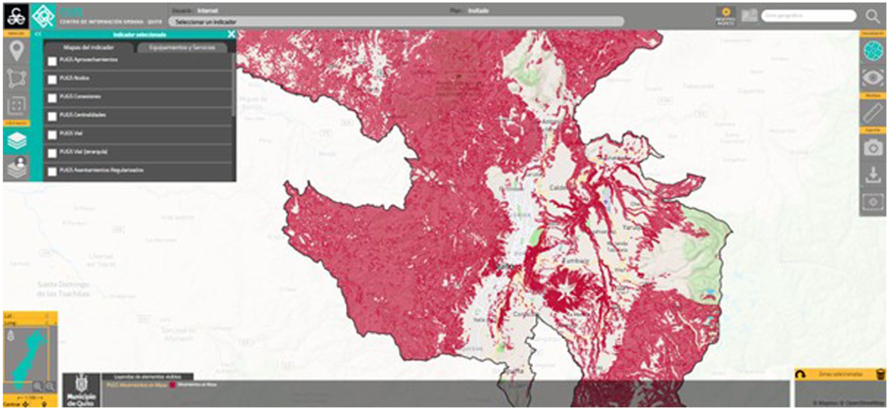
Example of the mapping of mass movements (landslides and debris flows) for the Quito area
The results of our analysis are shown in Figure 2 for Quito’s urban expansion from 2000 to 2020 in five-year intervals. Urban expansion has occurred primarily around the edges of the city, particularly to the north, south and east, reflecting the lack of available land for urbanization within the existing city. Urbanization was strongly concentrated to the east of the city between 2000 and 2010, becoming more fragmented between 2015 and 2020. There is a strong correlation between the location of hazard events (which typically occur on steeper topography around the edges of the historic city) and areas of current urban expansion. The hazard events shown in Figure 2 are a sample of the largest hazard events in each five-year period whose locations exactly match an area of urban development – additional hazard events also occur in close proximity to those areas but are not shown in Figure 2. Overall, there are 30 to 50 hazard events in each five-year period with one hazard event per 0.8 km2 of land urbanized. In this analysis, urbanization is defined as the change of land cover type, and so we cannot distinguish between formal (planned) settlements and informal occupation of land.
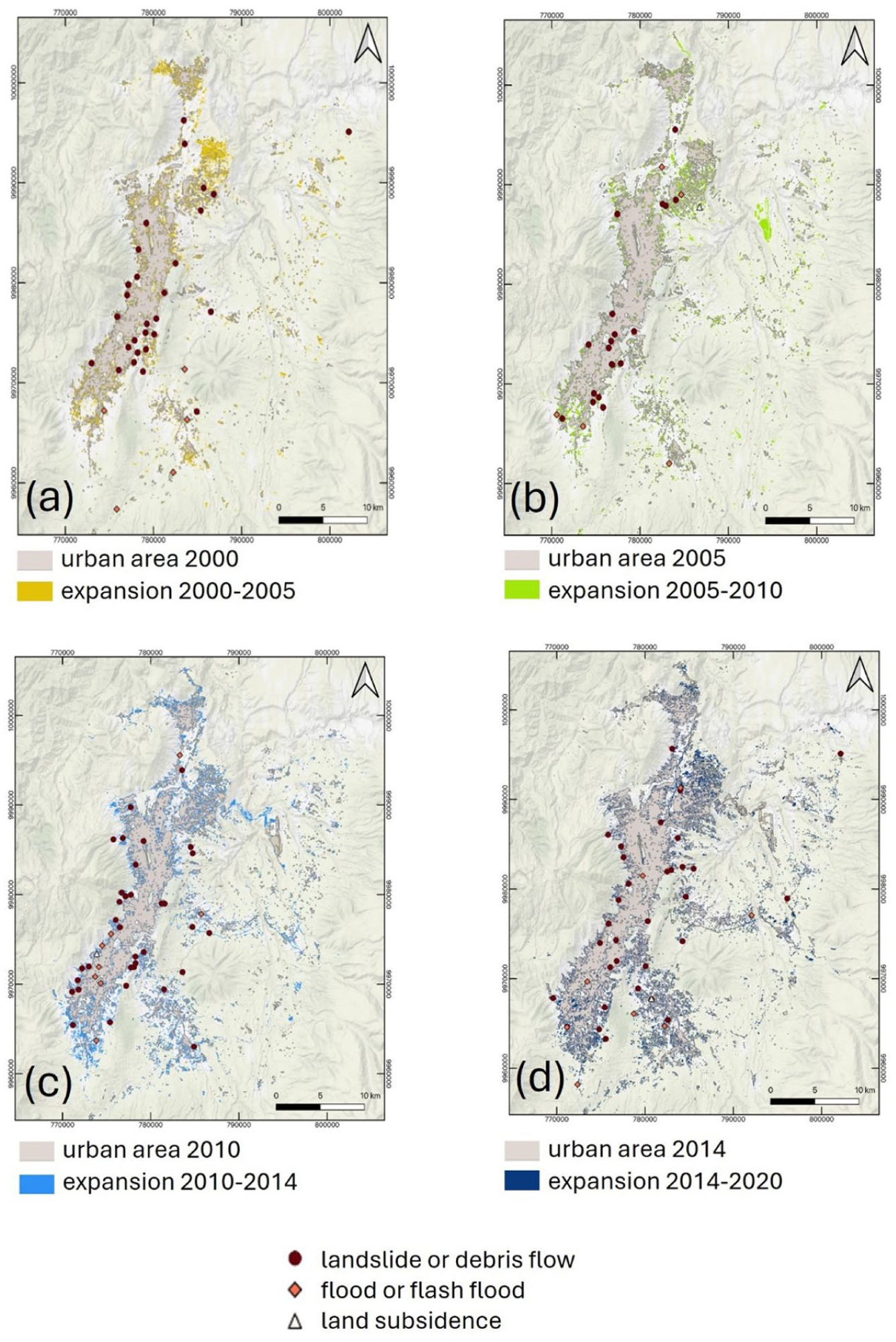
Maps showing the correlation between areas of urban expansion in Quito and recorded hazard events for the time periods: (a) 2000–2005; (b) 2005–2010; (c) 2010–2015; (d) 2015–2020. Areas of expansion are shaded, and symbols show individual hazard events by type
This analysis highlights that urban expansion in Quito results in “moving into danger” – areas of recent expansion have a high occurrence of hazard events. In the remainder of this paper, we focus on a specific urban development case-study, a settlement on the northern edge of the city exposed to natural hazards.
b. Planned development of Santa Rosa de Pomasqui, Quito
Santa Rosa de Pomasqui is an informal settlement situated 16 km to the north of the centre of Quito (Figure 3a). It is undergoing regularization(32) and planning for the creation of new homes and public amenities, and is the example of risk-sensitive urban development studied in this paper. The neighbourhood lies along the Monjas river and between the Pacpo hills to the east and the Casitahua hills to the west. The particular location planned for development is on the eastern side of the Simón Bolívar highway, which runs parallel to, and east of, the Monjas river (Figures 3a, 3b). It is an area of 0.17 km2 with a population of 1,039 people occupying 249 buildings. The area is exposed to landslides and debris flows from the Pacpo hills (Figure 3b), and it was significantly impacted by a debris flow in July 2022, highlighting the need for risk-sensitive development.
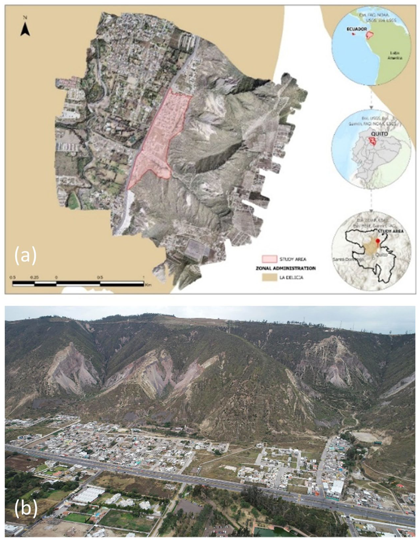
The settlement of Santa Rosa de Pomasqui, Quito: (a) aerial image and maps of the settlement location; (b) aerial photograph of the settlement looking east, showing the built environment either side of the Simón Bolivar highway, and landslide and debris flow sources on the steep slopes of the Pacpo hills
The location to be regularized and developed is shown as the shaded polygon in Figure 3a, and immediately to the east of the Simón Bolívar highway in Figure 3b. Planned development will incorporate the existing residents’ future visions (see section III a), which include new homes on the green space at the centre of Figure 3b, infilling of existing housing with new homes, and the creation of communal spaces for horticulture and sport. The neighbourhood and park to the west of the Simón Bolívar highway are formal settlements, situated in close proximity to the location to be developed.
c. Structure of urban development governance in Quito
The government of Quito follows a metropolitan municipal model, in which the administration’s major responsibilities are planning and management of land use, and management of basic services, transit and transport.(33) Under Ecuador’s 2008 constitution, the metropolitan municipality of Quito may form zonal administrations for improved local management capability. The constitution also stipulates that territorial organization is nested according to regions, provinces, counties (municipalities) and rural parishes. The 2010 Code of Territorial Organization, Autonomy and Decentralization (COOTAD) established the requirement to develop territorial plans to regularize informal settlements, prevent their further formation, and to guarantee the safety of the population in areas of natural hazard risk.(34)
Formal urban planning in Quito thus falls under multiple urban development governance organizations. The Municipality of the Metropolitan District of Quito (DMQ) Secretariat of Planning oversees the planning of new development, and the regularization of informal settlements. Implementing annual operational plans is the remit of the Secretariat of Territory and Habitat. The Directorate of Risk Management, which is part of the DMQ Secretariat of Citizen Safety, is responsible for the technical assessment of potential impact of natural hazard events on planned urban development. Santa Rosa de Pomasqui falls under the ‘La Delicia’ zonal administration of Quito,(35) whose role is to implement the responsibilities of the DMQ at local level, including managing both preparedness planning and emergency response for natural hazards.
The urban development context for Quito clearly highlights the need to consider the potential impacts of hazard events on future urban development, even when knowledge of those events may be limited, and the need to develop this knowledge across multiple urban development governance organizations (and, ideally, across any communities at risk). In the rest of this paper, we describe the prerequisites and the detailed structure of a workshop designed to achieve this rapidly, and we critically reflect on the learnings and outcomes.
III. Context for the Rapid Participatory Modelling Workshop Presented in this Study
a. A convening process
Any form of participatory modelling of natural hazard events to inform urban development must be situated within the formal regulatory processes of urban planning and risk management specific to the location under consideration.(36) Historically, these processes have often been imposed by municipal or national government structures, but there is now significant evidence that wider engagement, bringing together different perspectives and knowledge claims, with participation from a broad range of stakeholders, including potentially affected communities, is critical to ensure quality outcomes to the benefit of those most impacted.(37)
In this paper, we use the term “convening process” to refer to the formal structure within which planning decision-making takes place. This includes engaging and building trust across stakeholders, and technical activities such as hazard modelling. Leyden and co-workers(38) review a wide range of participatory convening processes for urban planning decision-making. These take various forms, from traditional face-to-face workshops and meetings to novel information and communication technology (ICT) strategies, or a combination of both.
The participatory convening process in place for this study in Quito was known as the Laboratorio Urbano (urban lab). The Laboratorio Urbano was developed through a series of workshops in 2021 and 2022,(39) organized by academics from the La Facultad Latinoamericana de Ciencias Sociales (FLACSO; Latin American Faculty of Social Sciences) and the Escuela Politécnica Nacional (EPN; National Politechnic University). It was conceived as a co-created space for multi-stakeholder dialogue to foster a supportive environment for decision-making, build trust across different stakeholder groups, and generate a risk culture in all sectors of the city. Participants were drawn from the national government (including the National Risk and Emergency Management Service, National Planning Secretariat, Ministry of Environment, Water and Ecological Transition, and Ministry of Urban Development and Housing), the DMQ (including the Secretariat of Planning, Metropolitan Institute of Urban Planning, Security and Governance Secretariat, Secretariat for Environment, Secretariat of Territory, Habitat and Housing, the zonal administration of areas identified for development, and the Metropolitan Public Company for Drinking Water and Sanitation), and civil society organizations (including neighbourhood organizations from areas identified for development, the Association of Architects of Pichincha, and the Association of Risk Management Professionals in Ecuador).
At the time the Quito rapid participatory modelling workshop was run, the Laboratorio Urbano had already supported community-led future urban visioning, resulting in a spatial plan that included new homes and green space.
b. Hazard knowledge
Sources of hazard knowledge are needed to inform the convening process and the use of models as the basis for quantifying potential hazard impacts. A shared understanding of hazard processes and terminology is also necessary among participants to facilitate dialogue and knowledge exchange. These knowledge sources can take the form of records of observed hazard events, their extent and impacts, as well as broader knowledge of the hazards by type, whether in educational materials produced and shared by researchers or authorities, or from participants’ recollections of individual events. If communities or the public are involved from an early stage as participants, they can provide critically important knowledge, particularly of smaller events less likely to be recorded in national or international databases.(40) However, given that participatory processes involving communities are emergent, rather than ubiquitous,(41) hazard information is very often limited to authorities’ responses to hazard events and reports of these events in broadcast and social media (for example, DesInventar database: www.desinventar.net). For the participatory modelling workshop, four sources of hazard information were available. In addition to their personal education and experience, the workshop participants all learned about the physical characteristics and impacts of hazards in Quito through at least one of three sources: academic educational materials that were delivered during the workshop (section IV); the DMQ atlas of hazard events and infrastructure impacts (part of municipal planning and risk management staff training);(42) and the public education “Reducing Risks in Quito” digital platform (reducirriesgosenquito.com).(43) A fourth source of hazard knowledge was the morpho-climatic database of extensive hazard events in Quito (described in section II a), which provided the information on specific hazard events modelled in the participatory workshop.
c. Rapid models and visualization tools
Participatory modelling of natural hazards events with stakeholders is not new. Many studies have been reported, typically in-depth and designed around multiple workshops over many months, that have allowed participant engagement and accessibility.(44) These relatively lengthy processes place few limitations on the time needed for the models to run, or to create visualization of the model results. However, for a rapid participatory workshop we need models that can run quickly and provide real-time visualization of results. These models would ideally be the same as (or very similar to) those used by the scientific agencies to support risk-sensitive planning decisions, in order to ensure discussion of realistic hazard scenarios.(45) In this study, we trialled the use of a web-accessible physics-based model run on remote high-speed servers to both compute and visualize hazard events in a workshop setting.
The setup of the modelling scenarios can also be streamlined, both to speed up the modelling process and to simplify communication of scenarios to participants. In practice, the “hazard model” is not just the computational code. It also includes how and where the hazard is initiated, and the topography on which the computational code is solved, which is an approximation of the real surface topography. Simple pragmatic choices of hazard type, size and initiation location can be made, using previous events drawn from hazard knowledge, and the topography can be selected to be of “just sufficient” resolution to reproduce the location of interest. This can minimize the model run times, while allowing the difference between event sizes or uncertainty in the source location to be explored by participants during the workshop across multiple model runs. In this way, we define the concept of “just good enough” hazard modelling – a restricted set of simulations using simplified but typical initial conditions and bold but reasonable parameterizations, sufficient to allow adequately realistic simulation of future hazard events in order to explore different risk-sensitive planning options.
The LaharFlow model(46) (www.laharflow.bristol.ac.uk) was used for debris flow and landslide simulations within the rapid participatory modelling workshop. LaharFlow is a dynamic flow model for shallow surface flows of water and sediment that has been calibrated and widely used for volcanic mud flows (“lahars”), urban flash floods and debris flows, and glacial lake outburst floods. There are currently more than 400 users globally. The model solves the fundamental equations for conservation of mass and momentum for a shallow layer flowing across topography, and includes parameterizations for processes of erosion and deposition of solids that are a fundamental control on the dynamics of these flows. It does not generate risk estimates. A full description of the model, including its governing equations and parameterizations, is given by Phillips and co-workers.(47) LaharFlow has also been calibrated for urban landslides in Quito. Crucially for this participatory application, LaharFlow is accessible via an interactive web interface with which the users can visually set up simulations on in-built 30 m global or user-supplied topography, set source locations and adjust parameter values (see Figure 4). The web interface shows a series of maps of modelled flow properties including extent, depth and speed that update as the simulation proceeds. At any time during the simulation or after it has completed, users can download individual maps for display in geographic information system (GIS) software such as QGIS.
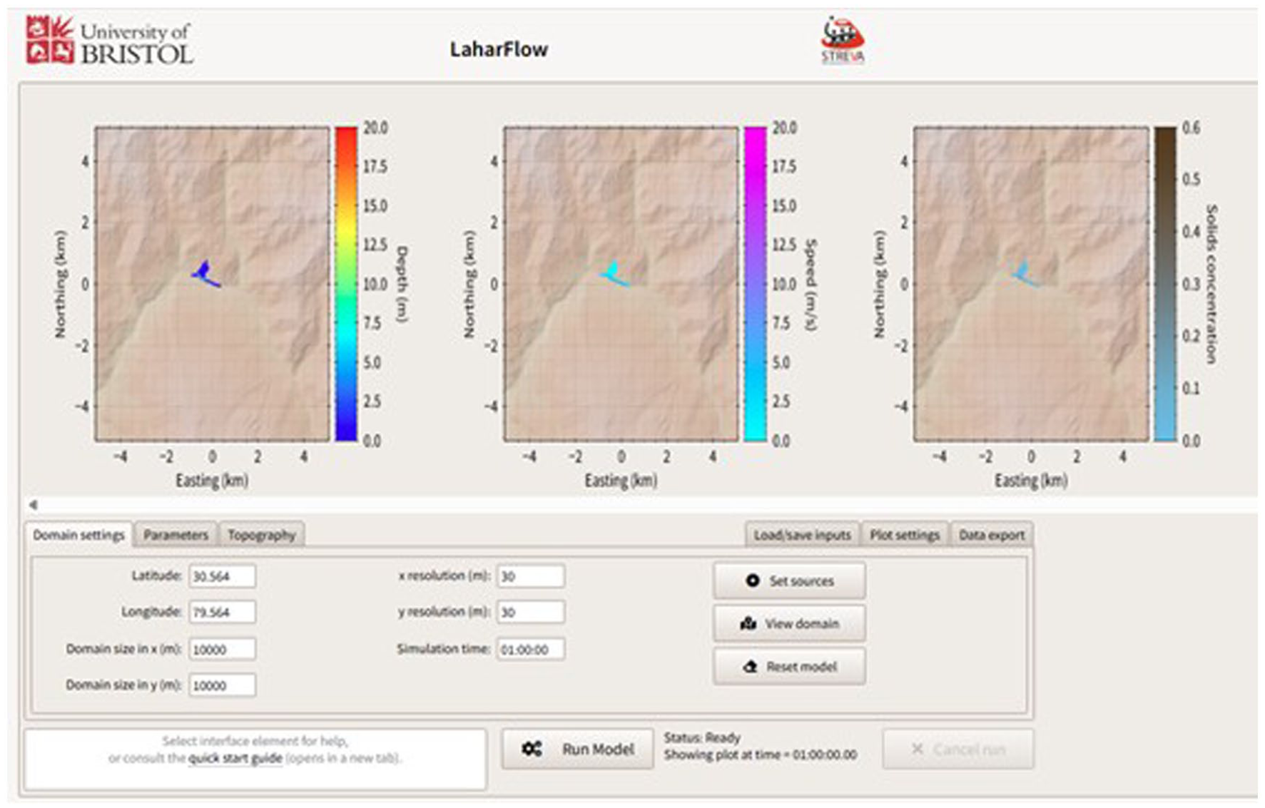
The LaharFlow web interface showing dialogue boxes for setting the model source conditions and user-selectable maps of flow depth, speed and solids concentration that automatically update on the screen as the simulation proceeds (www.laharflow.bristol.ac.uk)
IV. Detailed Description of the Workshop
The rapid participatory modelling workshop took place over two mornings on 16 and 17 January 2023. Twelve people participated from the DMQ Secretariats of Citizen Safety and Environment (five staff), the DMQ Secretariat of Planning (four staff) and the zonal administration of La Delicia (three staff). Together, these agencies make up the urban planning governance organizations for Santa Rosa de Pomasqui. Two additional participants were an architect from the Association of Architects of Pichincha and an academic geotechnical engineer from EPN. As the purpose of the workshop was to explore how rapid modelling could support the activities of organizations charged with managing risk and urban planning, there was no independent participation of community members or civil society organizations at this event. However, the locations used for the participatory modelling were those identified by the residents of Santa Rosa de Pomasqui for creation of new homes and green space, and two of the zonal administration staff were residents of Santa Rosa de Pomasqui. The meeting was facilitated by three academic staff from both FLACSO and EPN, and two academics (with expertise in historical knowledge of hazards in Quito and hazard modelling) from Universidad San Francisco de Quito (USFQ) and the University of Bristol, UK (UoB). Simultaneous translation between Spanish and English was available throughout the plenary and group activities. The reflections and interpretations presented below are taken from notes made by the facilitators during the workshop discussions. After the workshop, the eight facilitators met to identify views and opinions that were common to multiple facilitators’ notes and these were compiled and anonymized. Coding or statistical analysis of comments was not undertaken due to the small number of participants. At the end of each day of the workshop, the results were fed back to the participants, who had the opportunity to provide their views. After the workshop, a summary of the activities and discussions was shared with the DMQ Secretariats of Planning and Citizen Safety, and the zonal administration of La Delicia, but no feedback was received from them.
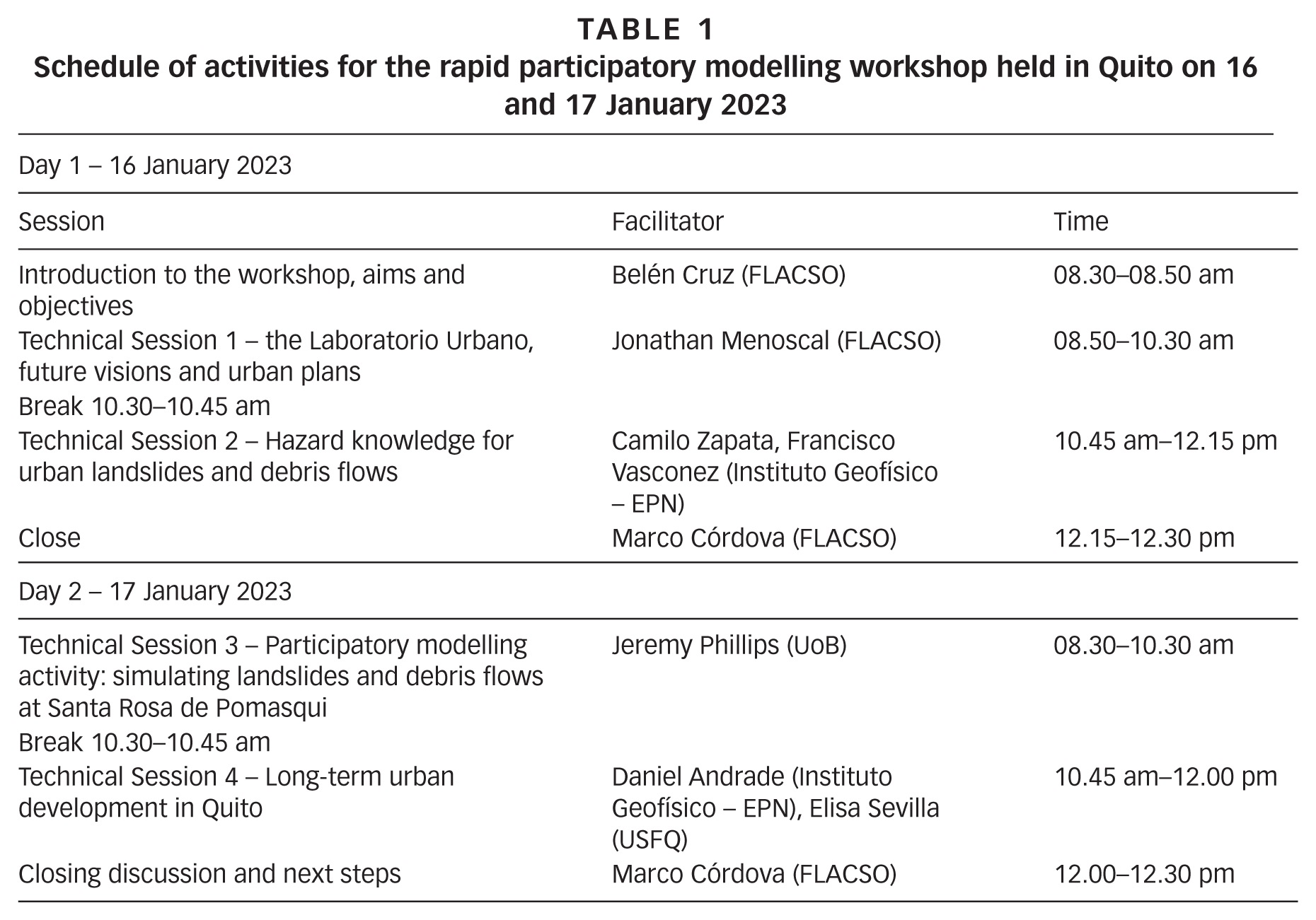
The workshop programme is shown in Table 1. Participatory exercises and taught sessions on governance of urban development and hazard knowledge took place on the first day, and the main participatory modelling exercise took place at the start of the second day. The first technical session on day one focused on learning from the Laboratorio Urbano, and was framed around discussions of the implementation of risk management policies in Quito, and the community-led future visions for urban development of Santa Rosa de Pomasqui. There was a consensus among participants that risk management was currently reactive to hazard events. One municipal risk manager described the approach as akin to a “military defence” response. The group agreed that risk management policy was fragmented across different governance levels (municipal and zonal administrations) within Quito. A member of the zonal administration and the architect together noted that while there are formal processes for management of waste and the built environment, these are not linked to risk reduction from natural hazards, and different activities are not well coordinated. A member of the DMQ Directorate of Risk highlighted that recent budget reductions (following a change in municipal government) had reduced technical capacity within the Directorate of Risk for assessing susceptibility and impacts from mass movements, including hazard modelling, and had limited their ability to use the results of previous consultancy studies of hazard and risk across Quito. Similar challenges of complex and conflicted risk governance and the need for technical capacity within urban planning structures have been recognized in studies of urban development in India and Africa.(48)
Schedule of activities for the rapid participatory modelling workshop held in Quito on 16 and 17 January 2023
The future visions for the development of Santa Rosa de Pomasqui created by its residents were presented to the participants, with a reminder of the settlement’s layout and exposure to hazards (see Figure 3). The participants were invited to respond to the future visions, and consider how the formal planning process could respond to them. Participants recognized that the residents’ visions of areas of different communal land use (horticultural and sports spaces) could be important for reducing inequity within the community, and noted the opportunity for planning to support residents’ social cohesion with nearby formal neighbourhoods. In the discussion of how to formalize visions into urban plans, hazard information (from the municipal atlas of hazard events and impacts) was noted as important, along with the use of models as predictive tools. But a lack of capacity, particularly in modelling, was highlighted as an obstacle to their practical use.
The second technical session focused on equalizing hazard knowledge among participants. The major hazards affecting Santa Rosa de Pomasqui (and Quito more generally) are landslides triggered by slippage along active faults and rainfall, and debris flows generated by intense rainfall. The initiation mechanisms, dynamics and impacts of these hazards and their description in models was presented to the participants, using learning resources developed as part of the Tomorrow’s Cities Project (available from https://tomorrowscities.org/training/) to share hazard knowledge. The presentation on landslides included information on the classification of landslides, local information to identify susceptible locations and create susceptibility maps, and software packages that enable prediction of slope failure. The presentation on debris flows included consideration of flow composition and characteristics, how this is modified by processes of erosion and deposition of solid materials, and the encoding of these processes into models to predict debris flow dynamics and physical impacts. Group discussion at the end of these presentations acknowledged the importance of predicting the extent and impact of debris flows, which may be a significant threat to life, and also the challenges of acquiring the detailed geotechnical data needed to quantify landslide susceptibility. The distribution of technical capacity across different urban planning governance organizations was again highlighted as a challenge to producing the timely quantitative assessment of the extent and dynamics of hazard events.
The third technical session comprised a series of participatory modelling exercises, aimed at informing an understanding of future hazard impacts at Santa Rosa de Pomasqui. A 15-minute introductory presentation was linked directly to the debris flow modelling and landslide susceptibility mapping described in the previous hazard knowledge sharing session. The LaharFlow model formulation was described using diagrams (with no reference to the model equations), and the results of its application to previous debris flows and landslides in Quito were presented as maps of flow extent. The “just good enough” modelling approach that was adopted for this workshop focused on identifying source locations for hazard events at Santa Rosa de Pomasqui, either those where previous landslides and debris flows had occurred, or from a susceptibility map based only on topographic slope, with highest susceptibility corresponding to steepest slope (Figure 5). Preparing this map in advance of the exercise had anticipated the discussion about the challenges of obtaining sufficient geotechnical data for more detailed susceptibility analysis in the previous session, and provided a pragmatic alternative whose limitations could be discussed.
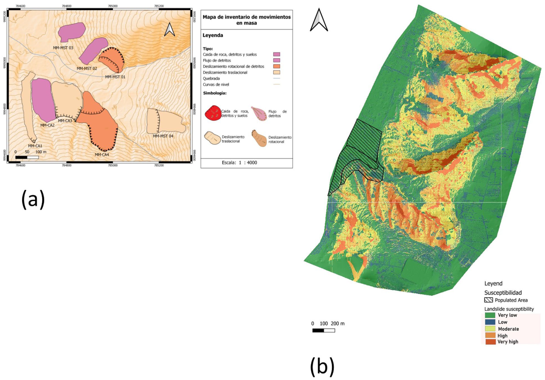
Maps of (a) landslide source locations from the morpho-climatic database of extensive hazard events for Quito, and (b) landslide susceptibility derived from topographic slope, shared with participants during the participatory modelling exercise
After this priming presentation, the participants self-organized into six groups. Each group was provided with a laptop and a login for the LaharFlow web tool. Each login accessed a pre-loaded source location and model parameters set from calibrations for either landslides or debris flows in Quito. Three groups ran landslide simulations with sources, sizes and durations that matched previously documented events in the morpho-climatic extensive hazards database for Santa Rosa de Pomasqui. The other three groups ran debris flow simulations with source conditions and durations comparable to previous events in Quito, and with source locations in channels that routed the flow towards the planned future development of the settlement. The simulations were computed using a pre-loaded 50 cm digital elevation mapping that had been acquired from drone photogrammetry at Santa Rosa de Pomasqui. Each group was supported by a workshop facilitator with experience of using the webtool interface, and some knowledge of the influence of the model parameter value settings. Once each group had reviewed and discussed their planned simulation with their facilitator, they started the simulation running. The LaharFlow web tool updates the on-screen maps of flow depth, flow speed, solids concentration and topographic change every one-hundredth of the duration set for the simulation (see Figure 4). For the topographic resolution used here, this meant the maps were updated approximately every 30 seconds. This high refresh rate meant that the groups could discuss the dynamic behaviour of the flows and the evolution of their extent to develop an intuition about potential flow impacts and warning times for existing built locations and places identified for development in the community’s future visioning exercises.
This first modelling exercise lasted about 30 minutes, during which time some group members discussed their simulations with others in different groups while the models were running (Figure 6). As a second simulation exercise, groups chose a location for the model source, based on the landslide susceptibility mapping, or on their interpretation or direct knowledge of the channel morphology around Santa Rosa de Pomasqui. Similar discussions took place within and across groups, with participants now exploring potential future hazards (albeit with the same size and characteristics as previous events) and discussing potential consequences and planning implications.
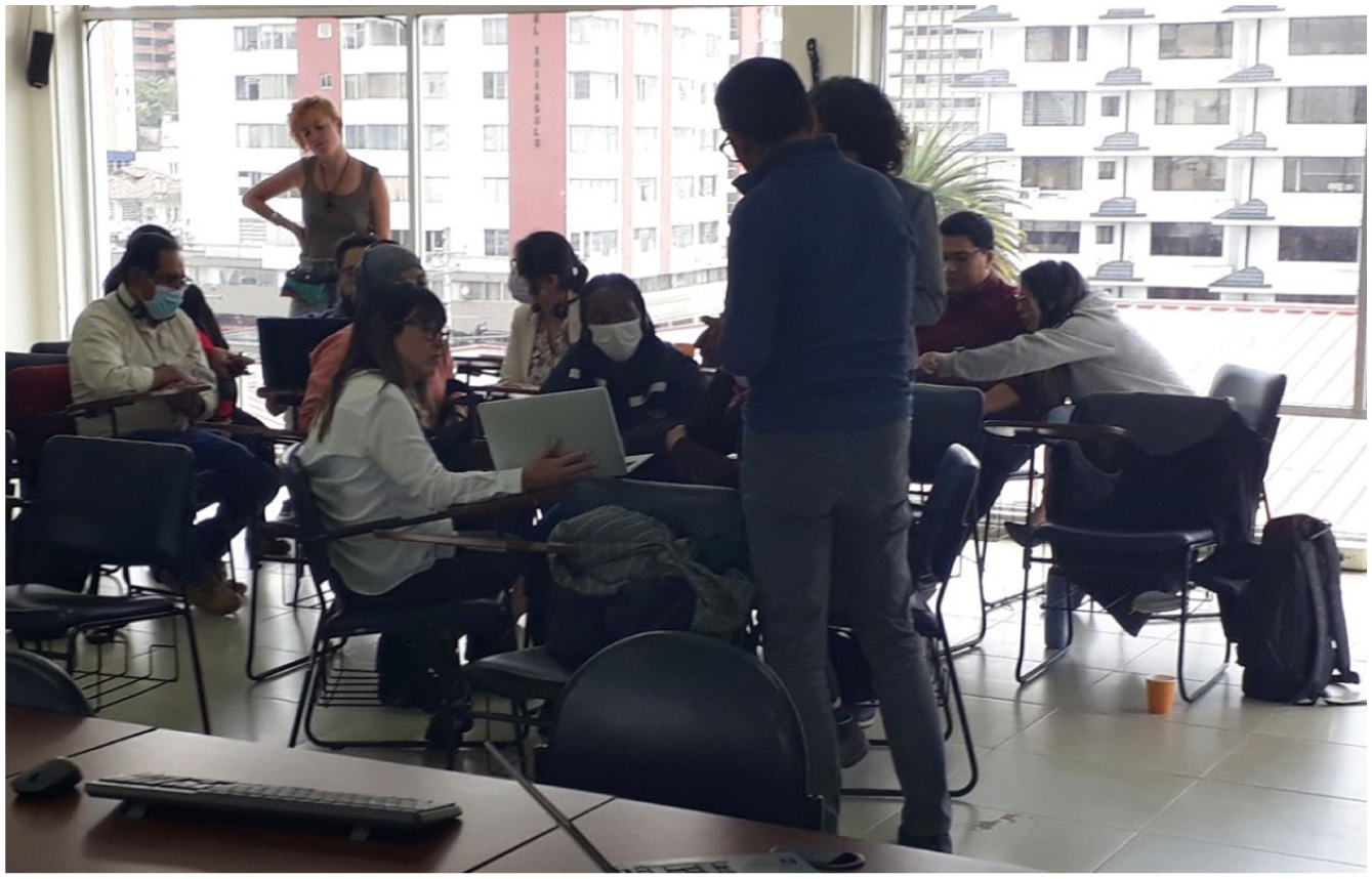
Workshop participants discussing their model simulations within and across small groups
The exercise concluded with plenary discussion. For the pre-loaded simulations, the results were already collated into a QGIS project, which allowed interactive display against aerial imagery that showed the settlement and important landmarks, along with other layers, including the susceptibility map and footprints of previous landslide events (Figure 7). Each group shared a description of the dynamics of their simulated flow, with participants who lived in Santa Rosa de Pomasqui (or had detailed knowledge of the location) focusing on the details of the model results and potential impacts. Those with less place-based knowledge (mostly from the Directorate of Risk Management) discussed more general characteristics of the hazards and potential uncertainties in the simulations. Broader discussion, including of the simulations that the groups had chosen themselves, recognized the value of using standardized, even simplified, methodology and starting points for modelling (and for data collection needed to run the models). The groups commented that seeing the dynamics of the flow develop and being able to discuss its spatial evolution in an interactive way helped them develop intuitions about the flow characteristics and supported the discussion of safe areas for development, and possible warnings for communities already living in affected locations. The groups recognized the greater hazard from debris flows than from landslides, given their longer and faster propagation. One risk manager highlighted the “need to understand more fully the dynamics of mass movements”.
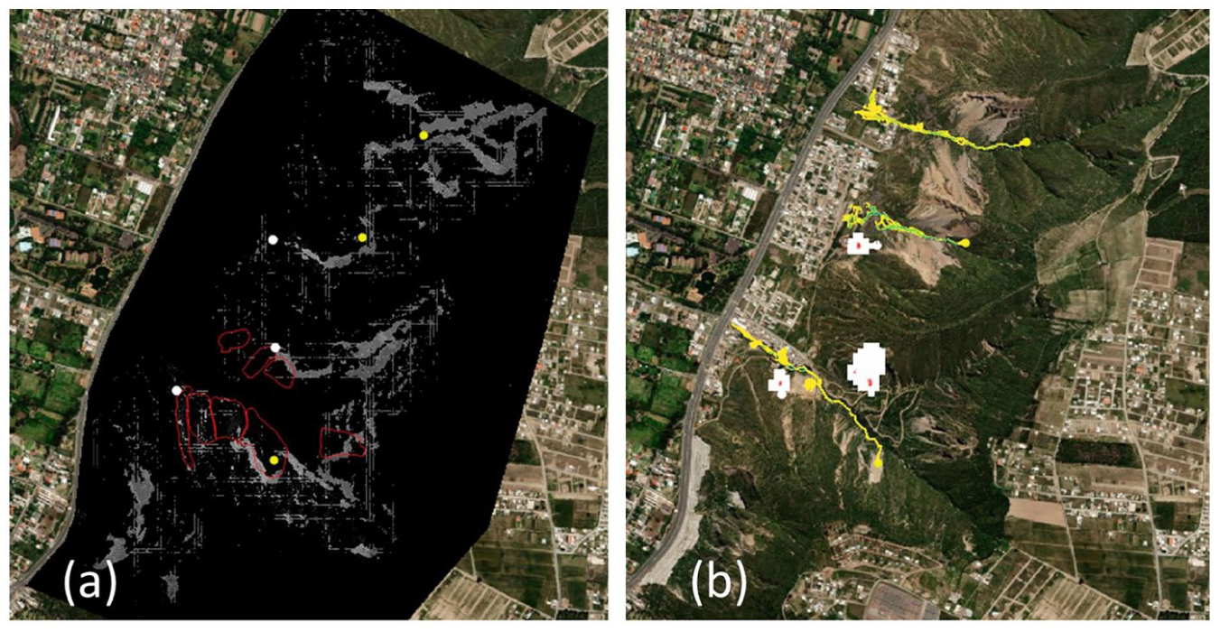
Screenshots of the QGIS project containing the pre-loaded simulation results that were used to support plenary discussion: (a) flow sources (white dots for landslides, other dots for debris flows), overlaid on the susceptibility mapping (lighter grey denotes higher landslide susceptibility) overlaid on aerial imagery of Santa Rosa de Pomasqui; (b) inundated areas from these hazards (white and blocky for landslides, elongated for debris flows) overlaid on aerial imagery of Santa Rosa de Pomasqui
The final technical session was a plenary discussion of longer-term urban development in Quito. The participants emphasized the value to the planning process of creating community-led future visions of their settlements, and recognized the importance of having information on hazard events and their potential impacts at the start of the planning process. There was a general consensus that the urban planning process for Quito should address long-term development; one member of the Directorate of Risk Management suggested that a time period of 12–15 years would be appropriate, although others noted that this is much longer than the term of municipal government.
V. Discussion: Critical Reflections on the Workshop Learnings and Outcomes
a. Learning from the participatory modelling exercise
A primary outcome of the participatory modelling workshop was the recognition that knowledge exchange around natural hazards, facilitated by the use of rapid and plausible hazard models, can be valuable for urban development governance organizations. This is true even if their staff already have significant existing technical expertise and experience in risk management and have had some exposure to hazard modelling. Participants with previous experience of responding to the aftermath of hazard events highlighted the significance of gaining new knowledge of the characteristics of those events and recognizing the knowledge gaps that were revealed when they were able to see and discuss the time-evolution of simulated hazardous flows on maps. Being able to experiment with the model during the workshop fostered discussion within groups about the information needed from observations of previous hazard events for modelling future events, and some of the associated uncertainties. The ability to layer model results over aerial imagery of the locations planned for development fostered conversations, particularly among participants from the Secretariat of Planning, about areas that should not be developed due to high exposure to hazards. The aerial imagery allowed participants to put the extent of areas impacted by hazard events into perspective because they could see features of known size, such as the road network and different building types. These observations suggest that the model itself (through its interactive web interface) and its outputs (both static and dynamic) function effectively as boundary objects across the different kinds of expertise required for risk-sensitive planning processes. The short duration of the workshop activities and discussions did not allow for a detailed investigation of the meaning of these boundary objects to individual participants, which would be an interesting future study, but their use did support nuanced conversations around broader dimensions of risk.
The ability to run these knowledge-exchange processes rapidly was particularly important to these urban development governance organizations because specialized hazard modelling is outside their remit. They do not have large amounts of time available to participate in the type of extended participatory modelling activities that have been described in previous studies.(49) In addition, they rely on external consultants to provide results that they subsequently review outside the context of the modelling, and without direct experience of the decisions made about model setup and parameterization. This makes it more difficult for them to understand and use the results of consultancy studies. One participant noted that they do not have the skills to follow up the results of these studies, which “remain on the shelf” and outside their active planning discussions. This points to the clear need for rapid participatory modelling within risk-sensitive urban planning, and for suitably experienced facilitators. In this workshop, academics (including the authors) researching natural hazard impacts were able to effectively facilitate the exercises and discussions. We suggest that this is because we were perceived as having no stake in the outcomes of the planning processes, and thus as outsiders to those outcomes. The workshop focused on supporting planning decisions for an active urban development case-study, placing the participants at the centre of decision-making and also prioritizing their operational knowledge and expertise. Rapid models and visualization tools are also required, and there is a steadily growing suite of open source web-based tools for hazard modelling and decision support – for example, the Tomorrow’s Cities Decision Support Environment (https://webapp.tomorrowscities.org), RiskScape (https://www.riskscape.org.nz) and the Oasis Loss Modelling Framework (https://oasislmf.org).
Creating plausible model simulations rapidly and from few observations of hazard events and their initial conditions can be challenging for hazard modellers. Academic and professional training in the use of hazard models correctly instils responsibility to create simulations of future events that are realistic. And model development over time typically adds to the number of model parameters and input measurements that are needed, with the aim of creating simulation results that show improved agreement with complex natural hazard event observations. This can lead to reluctance to follow a “just good enough” modelling approach and concern that tradeoffs in data availability, limitations and uncertainties will not be clear to end-users. However, placing modelling within a participatory setting, with associated recognition of the planning governance and underpinning hazard knowledge, allows discussion and immediate knowledge exchange around limitations and uncertainties. In this study, these discussions emerged organically during the group modelling exercise and plenary discussions. The participants were acutely aware of the limitations of the use of modelling, but had access to results that highlighted those uncertainties (for example, topographic resolution) and to experienced facilitators with technical knowledge of the influences of uncertainties on model predictions. We suggest that, if a “just good enough” modelling approach is undertaken, it should be undertaken within a participatory framework, and be clearly presented as distinctly different from more detailed modelling undertaken for hazard management and emergency planning.
b. Participatory modelling as a tool for opening dialogues
Embedding participatory modelling within a workshop that also included sharing hazard knowledge and reflections on urban planning governance in Quito provided an effective process for opening dialogues between participants. The participatory modelling itself provided a visual landscape against which the participants discussed specific aspects of the hazards and their impacts, reflected on their knowledge and prioritized needs for additional or deeper hazard knowledge (in this workshop, particularly knowledge of debris flows). The modelling effectively brought place-based and broader technical knowledge together, exemplified in plenary discussion from perspectives of different urban development governance organizations with different levels of knowledge of Santa Rosa de Pomasqui. The modelling exercise stimulated broader discussion about whether hazard events were exacerbated by anthropogenic activity, in particular the need to keep channels clear of rubbish so as to not increase the impact of debris flow events. The broader workshop framework, including presentation of the Laboratorio Urbano, stimulated discussion about the limitations of planning processes and the distribution of capacity across organizations. It supported participant reflections about important issues within risk-sensitive urban development, including priorities for short- and longer-term planning. These broader conversations evidence the co-creation of ideas and shared learning that is indicative of an effective participatory modelling process.(50)
Supporting dialogues among stakeholders is a critical step that is needed before policy development can take place. Our participatory modelling exercise provided the opportunity to open dialogues between stakeholders who were sharing their governance and hazard knowledge in a collaborative activity in which none of them were technical experts. This allowed open, equitable and constructive reflections on urban development challenges in Quito. However, the short timeframe did limit the scope of discussion and activities, and the value of the workshop could be enhanced by increasing its duration. The participants’ expertise spanned urban planning and management of risk from natural hazards, but there was little discussion of the detail of the community future-visioning plans, or specific impacts or mitigation of hazard events. It would be beneficial to align this expertise better with the plans, with appropriate facilitation to guide the process towards a constructive iteration of community future visions. The workshop activities included knowledge exchange and learning about the dynamics and impacts of debris flows and landslides, and a brief introduction to the use of an operational model to assess their hazard. An obvious addition would be to include more time (for example, two extra days) to provide specific training on the use of the model and analysis of its results. This would help to strengthen the technical support to the municipal departments in areas they identified as where they lacked technical capability.
c. Pathway to policy in Quito and beyond
Since the rapid participatory modelling workshop in January 2023, the DMQ Secretariat of Environment has created the Green and Blue Ordinance (2023), which supports urban development through the management of natural areas (Green) and water systems (Blue) to address disaster risk, climate change and biodiversity conservation. The Laboratorio Urbano convening framework will be adopted as part of this ordinance’s processes, and academics from Quito universities will have a role in supporting technical capacity, including hazard modelling.(51)
Many aspects of the use of modelling in risk-sensitive urban development in Quito that emerged through the participatory modelling workshop and analysis described in this paper are relevant to other global cities. Urban development typically takes place around the margins of existing urban areas, often resulting in occupation of locations that are exposed to impacts of natural hazard events. Opening dialogues and visualizing potential hazard impacts for different urban visions are key components of many urban development processes – even those with different mechanisms for convening, governance and technical capability. Limited technical capacity in hazard modelling is a challenge in many urban development locations. Few urban development governance organizations have the capacity to set up and use hazard models, instead relying on external consultants to provide results, which they then review and use with little detailed knowledge of how the models were used or their limitations. Thus, there is a range of opportunities to further develop rapid participatory modelling to support risk-sensitive development, as part of policies to guide the process of creating future urban visions and plans, and how models are used to inform decisions on which plans to adopt.
As demonstrated in Quito, rapid participatory modelling can provide an effective tool for opening dialogues, visualizing the impacts of natural hazard events on areas identified for development, and supporting technical capability for risk-sensitive urban development. We expect that these outcomes could also be achieved with less formal governance structures, without, for example, needing the complexity of the Laboratorio Urbano to provide structure to enable interaction between different stakeholder organizations. Looking further ahead, there are opportunities within risk-sensitive decision-support processes to use participatory modelling with communities, to provide hazard knowledge at earlier stages in the future visioning component of urban development planning.
Footnotes
Acknowledgements
The authors would like to thank the Municipality of the Metropolitan District of Quito Secretariats of Environment and Planning, and the Zonal Administration of La Delicia for their participation in this research. We thank Scott Watson for sharing Quito urban expansion data from the paper: ![]() , “Enhancing disaster risk resilience using greenspace in urbanising Quito, Ecuador”, Natural Hazards and Earth System Sciences Vol 22, 1699–1721. We thank Teresa Armijos Burneo for helpful discussions about this work and the manuscript, and Teresa Armjios Burneo and Jenni Barclay for their roles in co-designing and co-leading the wider Tomorrow’s Cities project research in Quito. We are grateful to Arabella Fraser, Cristina Sala and Gemma Cremen for helpful and constructive reviews and editorial suggestions that have improved this paper.
, “Enhancing disaster risk resilience using greenspace in urbanising Quito, Ecuador”, Natural Hazards and Earth System Sciences Vol 22, 1699–1721. We thank Teresa Armijos Burneo for helpful discussions about this work and the manuscript, and Teresa Armjios Burneo and Jenni Barclay for their roles in co-designing and co-leading the wider Tomorrow’s Cities project research in Quito. We are grateful to Arabella Fraser, Cristina Sala and Gemma Cremen for helpful and constructive reviews and editorial suggestions that have improved this paper.
Declaration of Conflicting Interests
The authors declared no potential conflicts of interest with respect to the research, authorship, and/or publication of this article.
Funding
The authors disclosed receipt of the following financial support for the research, authorship, and/or publication of this article: This research was supported by a United Kingdom Research and Innovation Global Challenges Research Fund award: NE/S009000/1, Tomorrow’s Cities Hub.
Ethical Approval Statement
This study was part of the participatory activities of the Tomorrow’s Cities project in Quito. Approval for these activities was granted by the Universidad San Francisco de Quito Research Ethics Committee in October 2019.
Consent to Participate
Informed consent was obtained verbally before participation, and recorded in accordance with procedures of the Facultad Latinoamericana de Ciencias Sociales de Ecuador, Quito, Ecuador.
Data Availability
The datasets generated during and analysed during the current study are available from the corresponding author on reasonable request.
12.
21.
32.
41.
44.
48.
Chu (2016); ![]() .
.