
Abstract
Peri-urban areas of mega-cities in lower-middle income countries face many environmental management challenges, including localized flooding caused by inefficient management and inadequate stormwater infrastructure. A case study analysis was conducted in Bangkok’s rapidly developing urban fringe, where residents have been experiencing localized flooding after normal rainfall. This paper explores the drivers of this flooding and its impacts for local communities, and explains how autonomous adaptation affects community stormwater drainage systems. The study found a mismatch between limited authority and transboundary problems of stormwater management, and calls for an integrated urban stormwater management approach. The findings imply the need to address autonomous adaptation as an integral part of adaptation measures at the broader scale of Thailand’s urban climate governance under the current threat of climate change.
Keywords
I. Introduction
The extension of mega-cities beyond metropolitan boundaries in Asia has resulted in the emergence of mega-urban regions and extended metropolitan regions (EMRs), where patchworks of urban development spill haphazardly over surrounding agricultural fields on the city’s fringe.(1) EMRs represent a paradoxical situation: while they are the fastest-growing areas in Asia, with a significant share of GDP each year, these transition areas are poorly endowed in terms of environmental and socioeconomic services from the central government, due to overlapping jurisdictions and unclear management responsibilities.(2) New roads and buildings from city core expansion interrupt and destroy existing hydrological networks and systems in areas once used for agriculture.(3) Within new developments, existing waterways and natural drainage networks are incorporated into stormwater infrastructure systems or simply filled up during the construction grading process.(4)
Mega-cities in middle- and lower-income countries with rapid economic growth and urbanization are still struggling with basic problems of urban flooding due to inefficient drainage systems and improper solid waste management.(5) There may be several reasons for urban flooding, including swollen rivers, coastal floods, pluvial and groundwater floods, and artificial system failures. Climatic conditions (e.g. extreme precipitation and flow) and anthropogenic activities (e.g. unplanned growth and development in floodplains) are considered the main drivers of urban flooding.(6) In areas with poor drainage infrastructure and large areas of impervious surface, high surface runoff after normal rainfall can create localized flooding, considered a minor flood type whose impacts are confined to the affected communities.(7) Localized flooding creates negative impacts for health, wellbeing and livelihoods, particularly for the peri-urban poor.(8) Inefficient drainage and wastewater infrastructure systems result from inappropriate policies, poor institutional arrangements, outdated mandates, and lack of funding.(9) Poor stormwater drainage management and flood control force private actors in different groups and on different scales to initiate their own flood adaptation and coping measures, which can sometimes lead to maladaptation.(10)
Several studies illustrate collective actions from autonomous adaptation in response to flooding within urban poor communities, which can reduce communities’ risk and vulnerability to climate change(11) and should not be seen as maladaptation.(12) However, some studies argue that spontaneous adaptation at any scale without shared information among actors and an integrated approach may lead to maladaptation and create serious impacts for the most vulnerable groups.(13) An intervention in one location or sector may increase vulnerability in another location or sector.(14) Adaptation measures undertaken by affluent communities, such as new investment in drainage infrastructure, often aggravate flooding problems in other city areas.(15) Thus negative externalities from autonomous adaptation in the peri-urban area deserve a closer look.
Focusing on one of the fastest-growing peri-urban areas in Bangkok, this paper explores how autonomous adaptation and coping measures in response to localized flooding can jeopardize a community’s public stormwater drainage management at local level and induce tension among stakeholders. The paper describes the drivers and impacts of localized flooding and explains how autonomous adaptation can become maladaptive.
II. The Concept of Autonomous Adaptation to Flood Risk
Autonomous adaptation refers to spontaneous acts driven by local experience to reduce risks from any specific environmental changes and enhance opportunities for wellbeing in the absence of official intervention and external support.(16) In urban poor communities, flood adaptation and coping measures can reduce communities’ risk and vulnerability to a significant degree.(17) However, autonomous adaptation can also cause an adverse impact when the decisions focus more on short-term outcomes than long-term threats, and this can exacerbate vulnerability to flooding.(18) Empirical evidence indicates that autonomous adaptation undertaken independently without an inclusive decision-making process can jeopardize the most vulnerable groups.(19)
Three scales of agents involved in flood adaptation are: institutions, communities, and individual households.(20) At the institutional level, adaptation involves planning and water resource management.(21) At the community and household levels, flood adaptation mainly involves modification of housing structures and the surrounding built environment to cope with floods. In terms of social measures, community members group together to share their efforts, knowledge and resources in negotiating with government agencies. Flood adaptation at community and household levels has its limitations because it can only generate minimally effective coping strategies, while the state’s central role can yield more inclusive and effective ones. It is necessary to opt for an integrative approach between the community and institutional levels.(22)
Along with these three scales of agents, the private sector (industrial and residential business) significantly contributes to local flood adaptation. The private sector’s adaptation possesses similar characteristics to individual households that adapt for their own interest within a certain boundary. However, the private sector’s adaptation can increase risk to surrounding neighbours, especially marginalized groups.(23)
In this paper, the concept of autonomous adaptation provides a framework for analysing physical and social responses to local flooding at the level of the individual household as well as the community, private sector, and institutions or public agencies in terms of their scale and activities. The concept also helps identify influential stakeholders in the study area’s stormwater drainage management.
III. Methodology
We selected a study area in the Pathum Thani province with a mix of farm and non-farm activities: the municipality of Lat-sawai (LSW). Within the LSW municipality, Village 5 was selected for a case study to observe localized flooding and local adaptation, and to capture the current state of stormwater drainage management at the local level of a typical peri-urban neighbourhood in Bangkok.
The study used mixed methods, with a combination of in-depth interviews, field observation and document review, to explore drivers and impacts of localized flooding and to explain how local communities adapt to it. The period covered was the rainy and flood season between May 2014 and January 2015. Purposive sampling(24) was used to select respondents who are either directly or indirectly in charge of local stormwater management (e.g. village headman, municipal engineer, irrigation officer, road engineer, provincial planners). The snowball method was used to select flood-affected households for interviews.
Two LSW municipality officers and seven civil servants at sub-regional offices (i.e. the South Rangsit Irrigation Office [SRIO] and Pathum Thani Rural Roads Office [PRRO]) were questioned to explain their responsibilities in local stormwater management and to describe how localized flooding occurred and affected the local stormwater drainage system. Eleven local residents were interviewed; they were asked to explain drivers and impacts of localized flooding, adaptation measures, and the municipality’s intervention in stormwater drainage management. The researchers also interviewed residents who had not encountered localized flooding to gain a background on LSW and past flooding incidents. Sketches and photographs from field observations were used as supporting tools during the in-depth interviews to communicate with local residents.
To triangulate the primary data collection, we reviewed documents and reports from government agencies, including Pathum Thani comprehensive planning reports, municipality and provincial development plans, and laws and regulations on the built environment (i.e. town planning acts, highway acts, land excavation and land filling acts, land allocation acts, and local ordinances).
Although this study is limited by its small sample size and single-case analysis, and cannot necessarily be generalized to other peri-urban areas with different socioeconomic and biophysical backgrounds, its scale did allow the researchers to establish a close association with the respondents and to capture the dynamic relationship between stormwater management and autonomous adaptation in a peri-urban area. Further comparative case analyses are recommended to supplement this study.
IV. Overview of the Study Area
a. Pathum Thani Province and LSW Municipality
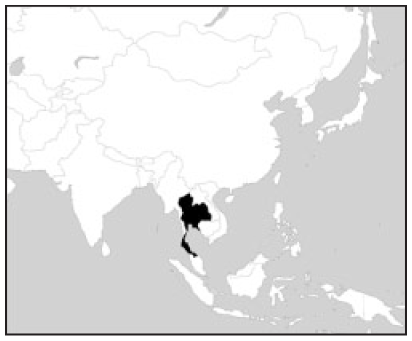
Pathum Thani Province is one of the five provinces that comprise the Bangkok Metropolitan Region (BMR).(25) Pathum Thani is situated in the floodplain of central Thailand, directly to the north of Bangkok. The per capita income is US$ 9,823. Pathum Thani is classified as tropical savannah, and it has much less rainfall in winter than in summer. In 2011, the average temperature was 28.1º C, with average annual precipitation of 1,426 millimetres, highest in September.(26)
Pathum Thani Province is bisected by the Chao Praya River, which runs north–south, dividing the province into the western and eastern parts. The eastern part is a large area of irrigated land, encompassing the four districts of Thanyaburi, Khlong Luang, Lum Luk Ka and Nong Suea. LSW is situated within the Lum Luk Ka district. The irrigation project, initiated in late 19th century by King Rama V, has resulted in a series of Khlong or canals within the area, where the main canals and lateral canals exist in a geometrical pattern.(27) In 1986, the unprecedented economic growth in Thailand transformed agricultural land use in Pathum Thani into industrial uses,(28) prompting the creation of factories and industrial estates, and accompanied by the emergence of new commercial and residential development in the existing agricultural fields.(29) Between 1952 and 2002, land use types in the province evolved from large plots of rice fields and orchards into a range of land uses including gated subdivisions, informal housing, apartments, townhouses, fishponds, wasteland, and some remaining rice fields and orchards.(30)
The LSW municipality encompasses a total area of 33 square kilometres and is located within the southern area of Pathum Thani Province, a 50-minute drive from central Bangkok. In 2015, there were 58,207 people in 34,157 households residing in LSW, with a population density of 1,764 per square kilometre. Between 1997 and 2012, LSW witnessed rapid urban growth, with the highest rate of migration among all the Lum Luk Ka districts. In 2014, LSW was home to 117 small or medium-sized factories, 81 housing developments and 14 condominium projects.(31) At present, there are two main roads that contribute to its urban development and transportation network. Highway 3312 runs east–west on the south side of the municipality; and the 3017 rural highway runs north–south in parallel with the Khlong 4 irrigation canal (Map 1). Around 2007, the upgrade of 3017 encouraged rapid residential development in LSW. In 2014, the Pathum Thani Rural Roads Office (PRRO) widened the 3017 road and installed an underground drainage system in response to the rapid increase in the urban built-up area in LSW.(32)
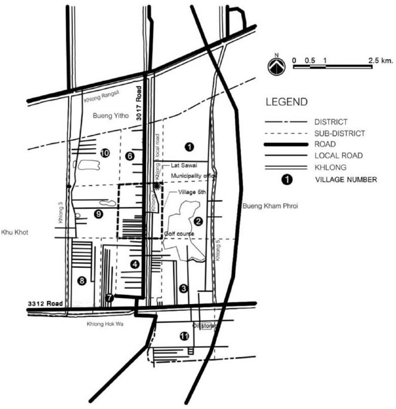
LSW municipality and its 11 villages
b. Village 5 case study background
Village 5, the largest of the 11 villages within LSW, had 24 per cent of LSW’s population in 2013 (Map 1), with 12,734 people and 6,613 households. For every 100 males there were 114 females.(33) Over the last 10 years, village 5 has experienced rapid development along the 3017 road, both residential and commercial. There are three main types of residential development: 1) subdivided land plots and shophouses, 2) old planned residential developments, and 3) new planned residential developments. We considered planned residential developments that occurred in the early 2000s as old developments, while those that occurred in the early 2010s and beyond are the new developments. These developments are situated within long and narrow land plots perpendicular to the 3017 road, a legacy of the former paddy fields.
V. Localized Flooding and Autonomous Adaptation
a. Localized flooding in Village 5 and its impacts
Within the past decade, communities and residents in Village 5 have experienced localized flooding related to rapid land development and failed drainage infrastructure. The village faces constant flooding, generally a mixture of stormwater runoff and sewage, and sometimes only sewage. Most low- and middle- income countries, including Thailand, tend to construct stormwater systems without separate provision for wastewater drainage, due to the high cost of construction. Stormwater runoff and sewage water thus travel within the same stormwater drainage system before being released into a water body without any prior treatment.(34) Localized flooding can occur over an extended period (i.e. three–six months) or many times a year, and it mostly appears as a shallow layer of standing water, enough to create difficulty in getting around and to present a hygiene concern to communities. We interviewed residents who suffered from localized flooding in the Roong-Rueng 2 housing development (RR2), Ruam-Sook subdivided land plots (RS1–RS10), and shophouses along the 3017 road (Map 2).
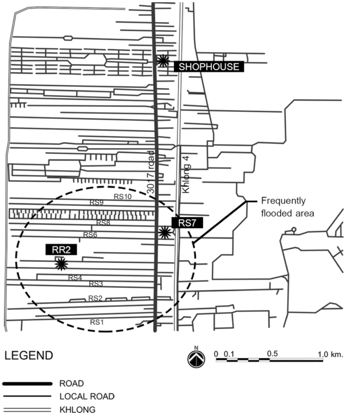
Flooded area found in Village 5
Residents from these three locations have to endure stagnant floodwaters for a long period. Flooding in RR2 lasted for four months in 2014 before it was temporarily resolved by LSW. A sewage flood in RS7 and shophouse buildings was caused by failed underground piping along the 3017 road (Photo 1). Sewer floods in the dry season and combined sewer and stormwater floods in the wet season have negatively impacted residents’ wellbeing and the physical environment of Village 5. Foul-smelling stagnant floodwaters contain floating trash and quickly become pathogen-contaminated areas and mosquito breeding grounds. Local residents develop skin rashes from wading through contaminated floodwater. Children lose play areas in front of their houses. Prolonged flooding damages the road surface, causing ongoing difficulty for local residents. The study found that some residents in RR2 and RS4 had abandoned their houses, and one family in RR2 planned to move out in the near future if the problem remained unsolved.
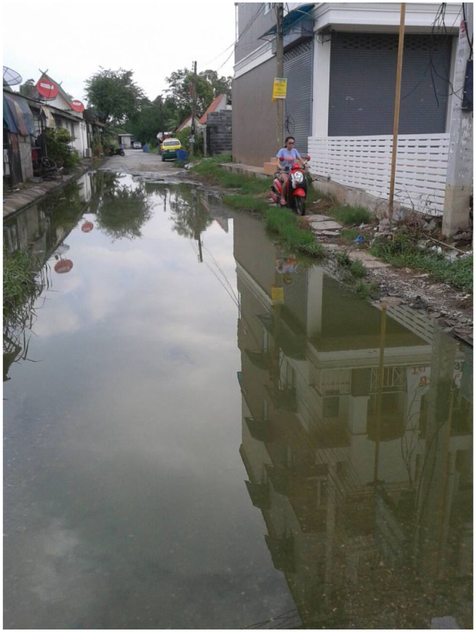
Sewage flood in RS7
b. The drivers of localized flooding in Village 5
The root causes of localized flooding in the LSW municipality are intertwined. They are mainly related to arbitrary land development and institutional incapacity, where regulations are ineffective and organizational performance falls behind public expectations.
Rapid urban development
In cities with humid tropical climates and high intensities of rainfall during the rainy season, inadequate and poorly maintained drainage infrastructure can cause widespread flooding.(35) Since 2004 a large number of new housing developments have emerged in LSW,(36) most of them along the 3017 road. New urban development has caused an increase in the extent of impervious surfaces and a decrease of agricultural fields as well as diminished small water networks, leading to a large volume of surface runoff. This phenomenon has put enormous stress on poorly maintained stormwater drainage infrastructure, where it exists.
Malfunctioning or absent public road drainage infrastructure
In the past, the only public drainage network within this irrigated area was the irrigation canal system established in 1888. Later, when these irrigated fields were transformed into more urbanized areas, the roadside drainage system became an intermediate drainage network linking new urban built-up areas with the existing irrigation canal system. Roadside drainage ditches collect runoff from surrounding development areas before conveying this runoff to the irrigation canals. During rapid urban growth in LSW, new construction along the 3017 road illegally interrupted and altered the existing roadside drainage ditches. Despite the provisions of Highway Act B.E. 2535 (1992), which prohibit any transgression within the highways’ right of way, the Pathum Thani Rural Roads Office (PRRO) faces difficulties in enforcing those rules due to inadequate human resources for on-site controlling and monitoring. (See the supplementary information online for a table detailing the relevant legislation.) The transgressions can be identified as follows: replacing ditches with smaller culverts than those required, mismatching new culverts and the existing underground drainage infrastructure, and simply filling up ditches without replacing any culverts below. As a result, the 3017 road drainage system was a mixture of underground drainage pipes, often inadequate in size, and open drainage ditches, which do not work well together.
The poor maintenance of these roadside drainage ditches also contributed to occurrences of localized flooding. Some parts of the 3017 underground drainage infrastructure were damaged in Thailand’s great flood of 2011, and have not yet been properly repaired. Currently, only half an hour of normal rain can result in flooding 10–15 centimetres high in RR2, due to the combined problems of a failed drainage system within the development itself and the failed drainage system of the 3017 road in front of the development.(37) Illegal alterations to the drainage system by private actors and PRRO’s insufficient maintenance of 3017 roadside drainage ditches have interrupted the flow of water and led to localized floods on the road.
In addition to malfunctioning of public road drainage infrastructure, there are public roads within LSW built without stormwater infrastructure, which can increase risks of localized flooding when the surrounding areas are densely developed. In the rural areas of Thailand, it is normal to observe new public roads built without any provision of stormwater infrastructure, cutting through vast open fields that attract new urban developments to the area along both sides of the road. Initially these new developments do not face stormwater drainage problems, since abundant open space can absorb runoff. However, when these areas become densely developed due to urban encroachment, problems of localized flooding tend to occur. The involved agencies then start to upgrade the roads and construct stormwater infrastructure, which sometimes can create drainage conflicts between the existing drainage system in private developments and the newly installed public road drainage infrastructure. In LSW, mismatched levels between the new stormwater infrastructure of the 3017 road and existing stormwater infrastructure in private areas interrupted drainage efficiency and increased local flood risk.
Absent stormwater infrastructure in private developments
Another driver of localized flooding is the lack of stormwater drainage infrastructure on developed land. The earlier land developments in LSW, known as Ruam-Sook (RS) developments, were subdivided land plots with no infrastructure preparation. These RS developments take the form of 10 alleys located perpendicular to the 3017 road, running from the RS1 alley to the RS10 alley (Map 2). Currently four of these RS development projects have no stormwater infrastructure,(38) including RS4 and RS7 in Village 5. These RS developments always face localized flooding. This kind of subdivided land plot development without any provision for stormwater infrastructure is prohibited by the Land Subdivision Act, B.E. 2543 (2000). The planned residential developments since 2000 have been legally obligated to provide internal stormwater drainage infrastructure within the development area.
Inefficient management and irresponsible development
The sectoral approach and lack of coordination among agencies at the local, sub-regional and provincial levels are also drivers of localized flooding in LSW. The provision and maintenance of public infrastructure in LSW is the responsibility of different agencies under different ministerial lines with specific laws and regulations. The LSW municipality is responsible for the provision and maintenance of public drainage infrastructure within public properties, including local roads. PRRO is responsible for the 3017 road, including its drainage infrastructure, while SRIO supervises irrigation canals.
In addition to the fragmented responsibility and regulations, there was a problem of legal validation. The plots that were subdivided before 2000, when real estate laws and enforcement were still in their early stages, tend to face localized flooding problems due to the absence of drainage infrastructure. Although the Land Subdivision Act of 1972 was updated in 2000, land developments that occurred before 2000 did not have to comply with the act’s requirements. Localized flooding in LSW’s subdivided plots was the consequence of inadequate guidance from the old real estate laws. Currently, rules and procedures for land allocation are clear and enforced by the Provincial Land Subdivision Committee. However, the Land Excavation and Land Filling Act, B.E. 2543, issued in 2000, does not limit the height of land filling in new developments, but only requires a drainage system that does not cause flooding in adjacent areas (see the online supplement). This gap allows unrestrained land levelling in new planned residential developments to elevate the ground level of the entire property. This has the effect of placing neighbouring areas in low spots, which are prone to localized flooding instead.
The 3017 road upgrade by PRRO could also increase risks of localized flooding. Most of the land developments in LSW used the 3017 road level as their grading reference. However, this level is not stable because the whole 3017 corridor has been through several upgrades at different times. Any time 3017 was upgraded and elevated, older developments were left behind at a lower elevation. The study found a lack of communication and coordination among agencies involved in the latest upgrade of 3017 in 2015. Although PRRO is the main agency initiating redevelopment projects, three additional agencies are involved: the LSW municipality, the Provincial Waterworks Authority of Pathum Thani (PWA), and the Provincial Electricity Authority Rangsit (PEA). The municipality complained about missing information from PRRO on the new 3017 road elevation and limited opportunities to raise its concerns to PRRO.(39) PRRO also faced a problem of underground water supply pipe obstruction from PWA. Unlike PEA, which was notified early enough by PRRO to accommodate the new electricity system for the road, PWA did not get any notification and was unprepared to rearrange the water supply piping system. As a result, PRRO had to initiate an on-site construction adjustment scheme, in which the diameter of the public stormwater pipe was reduced, allowing for less stormwater volume from private developments compared to the original construction scheme.
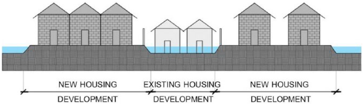
Improper grading within planned residential developments also leads to localized flooding. In the old days, when LSW was a small sub-district with limited resources and weak enforcement, many developments took place without a proper land grading process. Developers tried to reduce costs by filling up the front of plots to match the existing road level, while leaving the back area of plots at a lower elevation (Figure 1).(40) When it rains, the back portion of these properties is always the first to be flooded. The national government has tightened the grip on these developments by improving the outdated law (Land Subdivision Act B.E., 2543 [2000]) and initiating a new law (Land Excavation and Land Filling Act, B.E. 2543 [2000]). As a result, LSW’s planned residential developments with an uneven land filling pattern are the remnant of irresponsible development from the past.
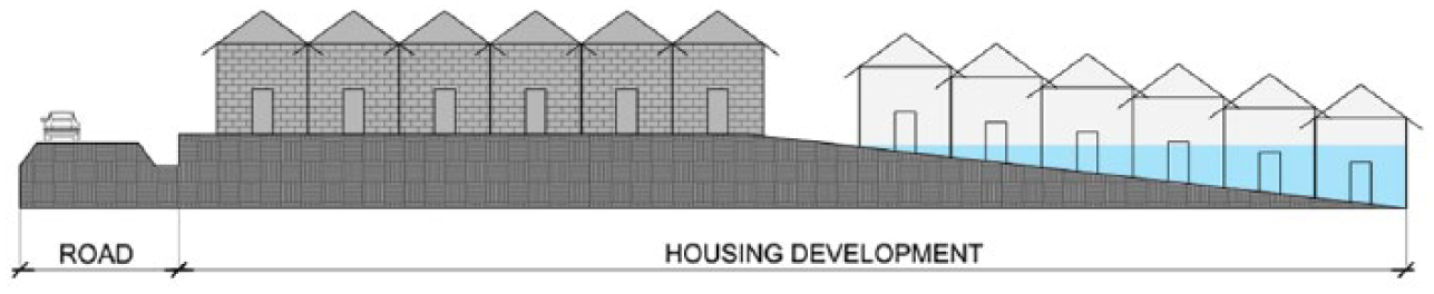
Improper grading can induce localized floods in the village
c. Actions by stakeholders that increase risks of localized flooding
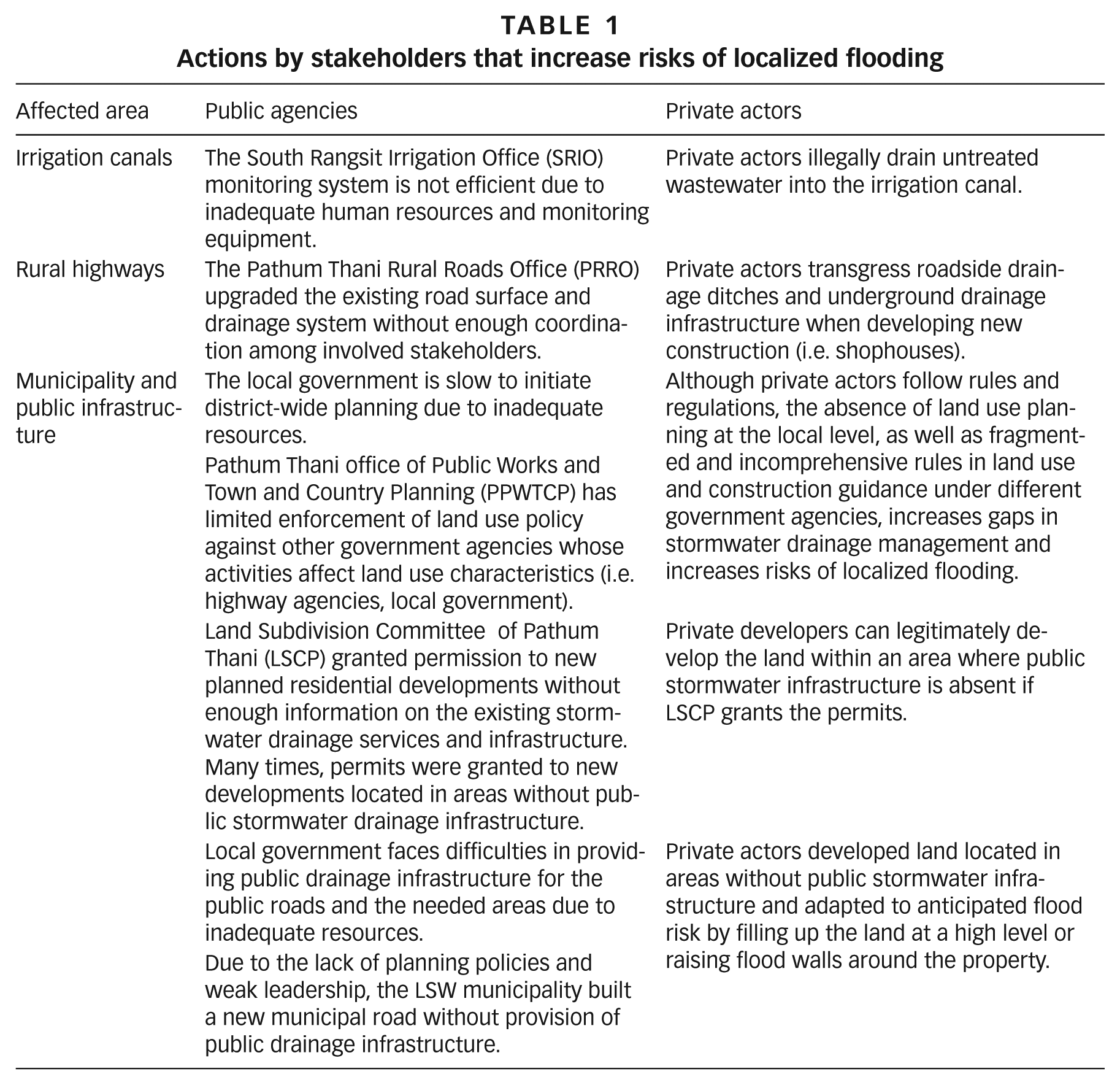
Most drivers of localized flooding explained in Section Vb are the result of improper land development by private actors (land developers, community, and individual households) and improper spatial planning and infrastructure development by public agencies. Those actions of both private actors and public agencies that increase risks of localized flooding in the LSW municipality are summarized in Table 1. Localized flooding, caused by actions of various actors and poorly managed by local government, leads to autonomous adaptation undertaken by private actors, described in Section VI.
Actions by stakeholders that increase risks of localized flooding
The study found that both the LSW municipality and the provincial agencies in Pathum Thani were overwhelmed by the short-term coping measures to lessen localized flooding problems. At the same time, Bangkok has experienced increases in both the frequency and intensity of heavy rainfall events in recent decades, due to increased temperatures.(41) Although climate change impacts are well recognized at the national level and by the city of Bangkok,(42) this awareness has not trickled down to the local governments in the BMR. Meanwhile, the current laws and regulations related to land use and water management under different government agencies serve only the mission of each agency under different ministerial lines of control, which do not acknowledge future threats of climate change. The LSW municipality and roads authorities have shown no recognition of future climate change scenarios. There is no evidence of a climate change agenda in any government development plans, either provincial or local, nor within the mission or vision statement of the Department of Rural Roads.
VI. Autonomous Adaptation and its Impacts
Although the negative impacts of localized flooding are obvious, the municipality’s responses have been slow and provisional. Therefore, local communities were forced to adapt by themselves (autonomous adaptation). To delineate and characterize local adaptation measures in the case study area, Table 2 summarizes the actions, outcomes and impacts of local adaptation undertaken by different types of private actors: individual households, the community, and the private sector. Individual households comprise residents of subdivided land plots, shophouses, and single houses outside planned residential developments. The community is the group of residents who reside in old planned residential developments abandoned by the developers without finishing the process of setting up the juristic person required by law. Thus, the residents have organized a housing committee to deal with localized flooding and other public facility issues. The private sector refers to developers and juristic persons whose actions affect the residents of the new planned residential developments.
Autonomous adaptation measures undertaken by various types of private actors
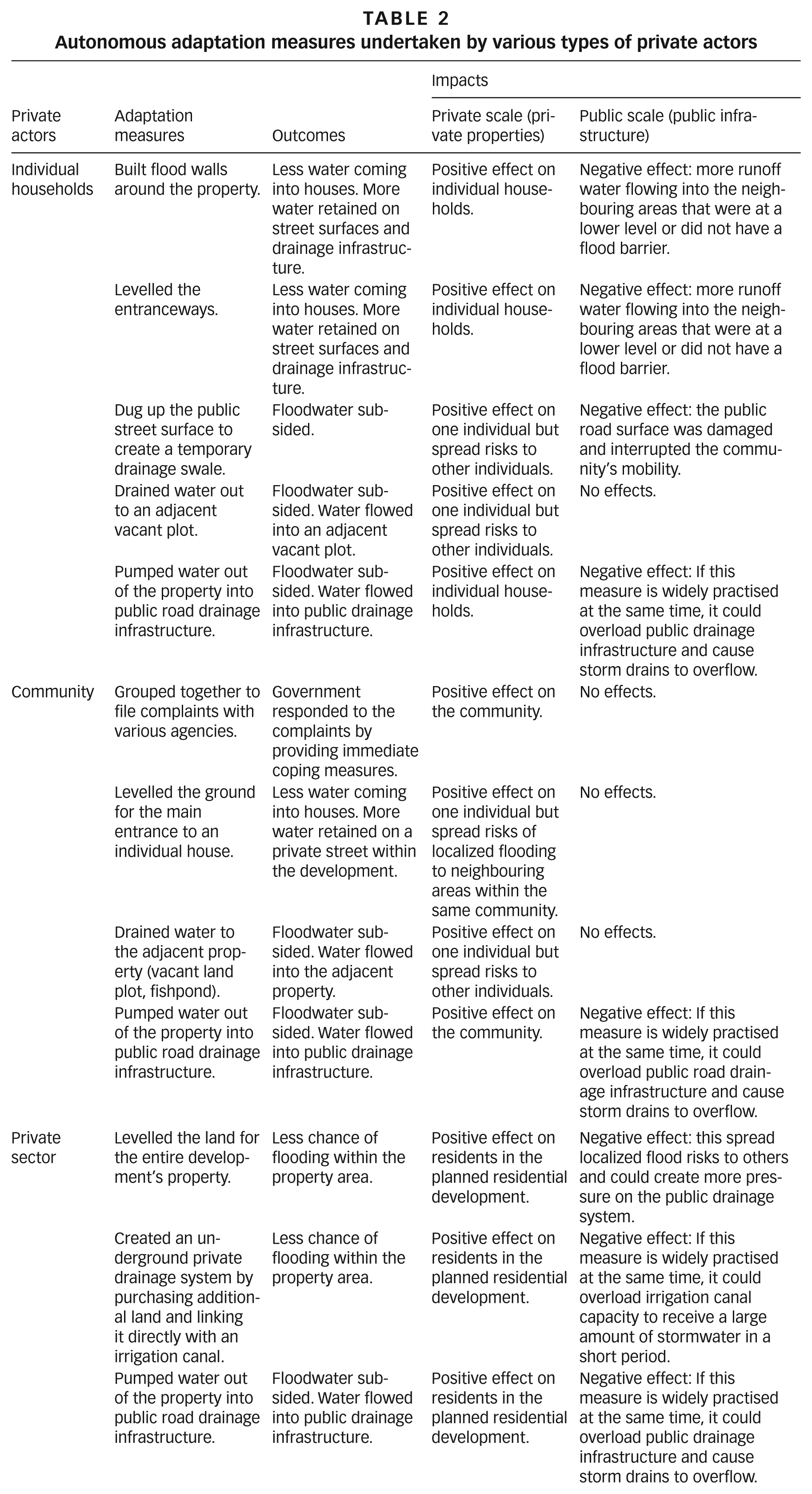
Autonomous adaptations benefited those who took an active role, yet at the same time they spread risks to others. For example, in RS7 the individual household dug up the road surface to create a temporary open swale to drain floodwater into a neighbouring vacant plot (Photos 2A and 2B). This action created negative impacts at both the public and private scales. At the private scale, the adjacent vacant plot was waterlogged. At the public scale, the damaged road surface interrupted the community’s mobility and the waterlogged vacant plot could become a mosquito breeding ground, which will affect surrounding neighbours’ health.
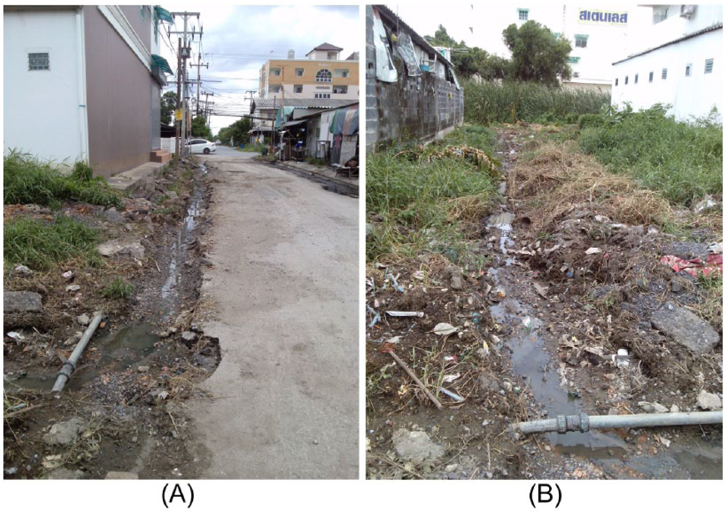
Autonomous adaptation by an individual household damaged the public road surface (A) and drained water out to an adjacent vacant plot (B)
Land developers’ land levelling in new planned residential developments can increase the risk of localized flooding in the neighbouring land areas (Figure 2). As planned residential developments in LSW continue to grow, the risk of localized flooding in old residential neighbourhoods tends to increase. With limited resources and authority, the LSW municipality could only cope and adapt to the situations with provisional measures such as filling up the flooded areas with gravel, creating an underground private drainage system, and pumping water out of property. These measures were effective within a limited area and were provisional, similar to those initiated by private actors.
Land filling by new developments imposes localized floods on neighbours
In term of social measures, the study found that the municipality responded to the complaints from well-organized groups of actors faster than those raised by individual households. After suffering prolonged localized flooding and filing several complaints to the municipality, with help from the village headman, the RR2 housing committee lodged a complaint with the military officer appointed by the National Council for Peace and Order (NCPO). The meeting with the deputy mayor, village headman and housing committee was held with the military officer, who acted as an intermediary. Finally, the municipality took action by initiating the temporary measures described in the previous paragraph. Unlike with the RR2 community, RS7’s filing of complaints did not lead to actions by the municipality. As a result, one individual household decided to undertake autonomous adaptation by digging up the road surface, as described earlier in this section.
The consideration of the advantages and disadvantages of autonomous adaptation depends on one’s perspective. Autonomous adaptations benefit individual households, communities, and the private sector, but they create negative impacts on public infrastructure and weaken the public stormwater system, as well as inducing tensions among actors. Some measures have already created negative effects on the environment and the community’s wellbeing, and some measures will increase the risks of local floods in the near future. Inadequate and inefficient official intervention has forced private actors to invent their own flood adaptation measures, which later could cause the entire public drainage system to fail. Autonomous adaptation at any scale tends to involve distributing risks to others, as excess water is drained outward onto public road surfaces or towards other open spaces nearby, which are likely to be developed soon. In the near future, as Village 5 reaches a mature stage of urbanization, localized flooding is to be expected.
VII. Discussion and conclusions
This paper investigates the drivers and impacts of localized flooding in the peri-urban area of a mega-city and explores how autonomous adaptation affects the local environment and community wellbeing. Localized flooding is triggered by multiple drivers associated with: rapid increase of the impervious surface within an urbanized area, malfunctioning or lacking drainage infrastructure in both private developments and public roads, irresponsible land grading in private development, and uncoordinated public infrastructure development between public agencies.
Rapid urban growth in LSW exhibits a common characteristic of EMRs: public services lagging far behind new construction.(43) New developments in LSW have occurred rapidly without sufficient guidance or enforcement. An irresponsible and haphazard development with inadequate and inefficient stormwater infrastructure have caused localized flooding. In line with previous studies of urban flooding,(44) drivers of localized flooding in LSW include: a rapid increase of urban built-up spaces within flood-prone areas, limited and poorly maintained drainage infrastructure, violation of laws, and weak local government. Violations of laws and regulations on land development and construction in LSW took the form of damage to public drainage infrastructure and illegal site grading. The municipality’s slow response to flooding problems and its provisional flood coping measures are examples of inept management, which can then encourage autonomous adaptation on the part of individual households, communities, and the private sector.
A lack of coordination between old and new urban development, and among different levels of governmental authority, also triggers localized flooding, as in the example of uneven grading. Fast urban expansion forces local government to provide public service immediately, without enough prior planning and guidance. The municipality’s administrative structure, which is incapable of meeting basic needs, can instigate autonomous adaptation at the local level. Development of public roads by the LSW municipality in response to rapid urban growth increases risks of localized flooding because there is no provision of public stormwater infrastructure on the road or any stormwater drainage management planning. Thus, the findings from this study are in line with the argument that weak urban governance drives individuals and businesses to develop independent responses to natural hazards and leads to maladaptation.(45)
Adaptation measures similar to those documented in previous studies of peri-urban poor communities(46) were found in LSW communities, in terms of both physical and social measures. Externalities of adaptation in peri-urban poor communities are often positive. Efforts, knowledge and resources, shared among community members, encourage potential upscaling in working with local governments. However, autonomous adaptations undertaken by private actors in LSW generated tensions among stakeholders.
Autonomous adaptation by the private sector increases vulnerability of communities and individual households. This finding is in line with previous studies, which argued that flood risk reduction in one settlement can increase flood risk in others.(47) Any local coping and adaptation strategies that divert risks and impacts in time and space, and create severe impacts on others, are considered maladaptation.(48) In terms of social measures, the study found that the municipality responded to the complaints from well-organized groups of actors faster than those raised by individual households.
The findings suggest that policymakers and government agencies who work in peri-urban areas of mega-cities in low- or middle-income countries should take a closer look into the root causes of localized flooding while addressing the immediate flood threats to communities. The establishment of local planning guidance and a local drainage plan is strongly recommended. Spatial planning and stormwater drainage management, engaging different levels of agencies in charge and drawing on community perspectives, will minimize the risk of localized flooding and maladaptation. Although this research focuses on negative externalities from autonomous adaptation, it is necessary to search for an institutional mechanism that would enhance the positive side of collective adaptation and inclusive urban stormwater governance.
This local case study reflects the necessity of adaptive and responsive local governance to strengthen Thailand’s urban climate governance at regional and national scales. Further comparative case studies on different sites within Pathum Thani irrigated fields as well as other sections of the BMR, where the historical context of land use might be different, would enhance the findings. Overall, additional research on stormwater governance is necessary to achieve more sustainable stormwater management in the dynamic context of peri-urban areas in developing countries under a changing climate.
Footnotes
1.
Allen, A (2010), “Neither Rural nor Urban: Service Delivery Options That Work for the Peri-urban Poor”, in M Kurian and P L McCarney (editors), Peri-urban Water and Sanitation Services: Policy, Planning and Method, Springer, Dordrecht, 300 pages; also McGee, T (2005), “Distinctive Urbanization in the Peri-Urban Regions of East and Southeast Asia: Renewing the Debate”, Jurnal Perencanaan Wilayah don Kata Vol 16, No 1, pages 39–55.
3.
Davivongs, V, M Yokohari and Y Hara (2012), “Neglected Canals: Deterioration of Indigenous Irrigation System by Urbanization in the West Peri-Urban Area of Bangkok Metropolitan Region”, Water Vol 4, No 1, pages 12–27.
4.
Braud, I, T D Fletcher and H Andrieu (2013), “Hydrology of peri-urban catchments: Processes and modelling”, Journal of Hydrology Vol 485, pages 1–4.
5.
Novotny, V, J Ahern and P Brown (2010), Water Centric Sustainable Communities: Planning, Retrofitting, and Building the Next Urban Environment, John Wiley & Sons, Inc., Hoboken, 624 pages; also Pastore, M C (2015), “Reworking the relation between sanitation and the city in Dar es Salaam, Tanzania”, Environment and Urbanization Vol 27, No 2, pages 473–488; and Varis, O, A K Biswas, C Tortajada and J Lundqvist (2006), “Megacities and Water Management International”, Journal of Water Resources Development Vol 22, No 2, pages 377–394.
6.
Jha, A K, R Bloch and J Lamond (2012), Cities and Flooding: A Guide to Integrated Urban Flood Risk Management for the 21st Century, World Bank, Washington, DC.
7.
Parkinson, J and O Mark (2005), Urban Stormwater Management in Developing Countries, IWA Publishing, London, 218 pages.
8.
See reference 7; also Eakina, H, A M Lernerb and F Murtinhob (2010), “Adaptive capacity in evolving peri-urban spaces: Responses to flood risk in the Upper Lerma River Valley, Mexico”, Global Environmental Change Vol 20, No 1, pages 14–22; Jabeen, H, C Johnson and A ![]() , “Built-in resilience: learning from grassroots coping strategies for climate variability”, Environment and Urbanization Vol 22, No 2, pages 415–431; and Thorn, J, T F Thornton and A Helfgott (2015), “Autonomous adaptation to global environmental change in peri-urban settlements: Evidence of a growing culture of innovation and revitalisation in Mathare Valley Slums, Nairobi”, Global Environmental Change Vol 31, pages 121–131.
, “Built-in resilience: learning from grassroots coping strategies for climate variability”, Environment and Urbanization Vol 22, No 2, pages 415–431; and Thorn, J, T F Thornton and A Helfgott (2015), “Autonomous adaptation to global environmental change in peri-urban settlements: Evidence of a growing culture of innovation and revitalisation in Mathare Valley Slums, Nairobi”, Global Environmental Change Vol 31, pages 121–131.
9.
See reference 8, ![]() ; also Haque, A N, D Dodman and M M Hossain (2014), “Individual, communal and institutional responses to climate change by low-income households in Khulna, Bangladesh”, Environment and Urbanization Vol 26, No 1, pages 112–129; and Wamsler, C and E Brink (2014), “Moving beyond short-term coping and adaptation”, Environment and Urbanization Vol 26, No 1, pages 86–111.
; also Haque, A N, D Dodman and M M Hossain (2014), “Individual, communal and institutional responses to climate change by low-income households in Khulna, Bangladesh”, Environment and Urbanization Vol 26, No 1, pages 112–129; and Wamsler, C and E Brink (2014), “Moving beyond short-term coping and adaptation”, Environment and Urbanization Vol 26, No 1, pages 86–111.
10.
This study uses the IPCC Annex II glossary as a basis to identify the concepts of adaptation and coping: “Adaptation” refers to any “process of adjustment to actual or expected climate and its effects”. “Coping” refers to “the use of available skills, resources, and opportunities to address, manage, and overcome adverse impacts of localized flooding in the short term”. See ![]() , “Glossary of terms”, in C B Field, V Barros, T F Stocker, D Qin, D J Dokken, K L Ebi, M D Mastrandrea, K J Mach, G-K Plattner, S K Allen, M Tignor and P M Midgley (editors), Managing the Risks of Extreme Events and Disasters to Advance Climate Change Adaptation, A Special Report of Working Groups I and II of the Intergovernmental Panel on Climate Change (IPCC), Cambridge University Press, Cambridge, UK, and New York, USA, pages 555–564.
, “Glossary of terms”, in C B Field, V Barros, T F Stocker, D Qin, D J Dokken, K L Ebi, M D Mastrandrea, K J Mach, G-K Plattner, S K Allen, M Tignor and P M Midgley (editors), Managing the Risks of Extreme Events and Disasters to Advance Climate Change Adaptation, A Special Report of Working Groups I and II of the Intergovernmental Panel on Climate Change (IPCC), Cambridge University Press, Cambridge, UK, and New York, USA, pages 555–564.
For maladaptation, this study uses the explanation from ![]() to describe any actions or investments that may increase vulnerability to climate change impacts. This can include the shifting of vulnerability from one social group or place to another; it also includes the shifting of risk to future generations and/or to ecosystems and ecosystem services. See Satterthwaite, D, S Huq, M Pelling, H Reid and P Romero Lankao (2007), “Adapting to Climate Change in Urban Areas: The possibilities and constraints in low- and middle-income nations”, Human Settlements discussion paper, International Institute for Environment and Development, London.
to describe any actions or investments that may increase vulnerability to climate change impacts. This can include the shifting of vulnerability from one social group or place to another; it also includes the shifting of risk to future generations and/or to ecosystems and ecosystem services. See Satterthwaite, D, S Huq, M Pelling, H Reid and P Romero Lankao (2007), “Adapting to Climate Change in Urban Areas: The possibilities and constraints in low- and middle-income nations”, Human Settlements discussion paper, International Institute for Environment and Development, London.
11.
See reference 8, Thorn et al. (2015); also see reference 9, Haque et al. (2014) and Wamsler and Brink (2014); and Arifwidodo, S D and O Chandrasiri (2013), “The relationship between housing tenure, sense of place and environmental management practices: A case study of two private land rental communities in Bangkok, Thailand”, Sustainable Cities and Society Vol 8, pages 16–23.
12.
See reference 8, ![]() ; also Odemerho, F O (2015), “Building climate change resilience through bottom-up adaptation to flood risk in Warri, Nigeria”, Environment and Urbanization Vol 27, No 1, pages 139–160; and Porio, E (2011), “Vulnerability, Adaptation, and Resilience to Floods and Climate Change-Related Risks among Marginal, Riverine Communities in Metro Manila”, Asian Journal of Social Science Vol 39, No 4, pages 425–445.
; also Odemerho, F O (2015), “Building climate change resilience through bottom-up adaptation to flood risk in Warri, Nigeria”, Environment and Urbanization Vol 27, No 1, pages 139–160; and Porio, E (2011), “Vulnerability, Adaptation, and Resilience to Floods and Climate Change-Related Risks among Marginal, Riverine Communities in Metro Manila”, Asian Journal of Social Science Vol 39, No 4, pages 425–445.
13.
Mycoo, M A (2014), “Autonomous household responses and urban governance capacity building for climate change adaptation: Georgetown, Guyana”, Urban Climate Vol 9, pages 134–154; also Schaer, C (2015), “Condemned to live with one’s feet in water?: A case study of community based strategies and urban maladaptation in flood prone Pikine/Dakar, Senegal”, International Journal of Climate Change Strategies and Management Vol 7, No 4, pages 534–551.
14.
See reference 13, Mycoo (2014); also Nchito, W S (2007), “Flood risk in unplanned settlements in Lusaka”, Environment and Urbanization Vol 19, No 2, pages 539–551; and Tucci, C E M (2001), “Urban Drainage Management”, in C Maksimovic (editor), Urban Drainage in Humid Tropics, International Hydrological Programme (IHP-V), Technical Documents in Hydrology No 40, Vol 1, UNESCO, Paris, pages 157–176, accessed 1 February 2016 at ![]() .
.
15.
Andjelkovic, I (2001), Guidelines on Non-Structural Measures in Urban Flood Management, International Hydrological Programme (IHP-V), Technical Documents in Hydrology No 50, UNESCO, Paris, 81 pages, accessed 1 February 2016 at
16.
See reference 8, Thorn et al. (2015); also see reference 13, Mycoo (2014); and Forsyth, T and N Evans (2013), “What is Autonomous Adaption? Resource Scarcity and Smallholder Agency in Thailand”, World Development Vol 43, pages 56–66.
17.
See reference 8, Thorn et al. (2014); also see reference 9, Haque et al. (2014) and ![]() .
.
20.
See reference 8, Jabeen et al. (2010); also see reference 9, Haque et al. (2014) and Wamsler and Brink (2014); reference 12, Odemerho (2015) and Porio (2011); and reference 13, ![]() .
.
21.
Næss, L O, G Bang, S Eriksen and J Vevatne (2005), “Institutional adaptation to climate change: Flood responses at the municipal level in Norway”, Global Environmental Change Vol 15, No 2, pages 125–138.
22.
Adegun, O B (2015), “State-led versus community-initiated: stormwater drainage and informal settlement intervention in Johannesburg, South Africa”, Environment and Urbanization Vol 27, No 2, pages 407–420.
23.
Ríos, D (2015), “Present-day capitalist urbanization and unequal disaster risk production: the case of Tigre, Buenos Aires”, Environment and Urbanization Vol 27, No 2, pages 679–692.
24.
Bryman, A (2008), Social Research Methods, 3rd edition, Oxford University Press, Oxford, 747 pages.
25.
Robinson, I M (1995), “Emerging Spatial Patterns”, in T G McGee and I M Robinson (editors), The Mega-Urban Regions of Southeast Asia, UBC Press, Vancouver, pages 78–108. The administrative levels and units in Thailand can be categorized into five levels: nation, province, district, sub-district and village. The village level is the smallest one and administered by the village headman.
26.
Thai Meteorological Department, Climate of Thailand, Thai Meteorological Department, accessed 23 November 2015 at
27.
Hara, Y, K Takeuchi and S Okubo (2005), “Urbanization linked with past agricultural landuse patterns in the urban fringe of a deltaic Asian mega-city: a case study in Bangkok”, Landscape and Urban Planning Vol 73, No 1, pages 16–28.
28.
Sheng, Y K and A Rahman (1995), “Housing Women Factory Workers in the Northern Corridor of the Bangkok Metropolitan Region”, in T G McGee and Ira M Robinson (editors), The Mega-Urban Regions of Southeast Asia, UBC Press, Vancouver, pages 133–149.
29.
Sundharawanich, C (1997), 100th Year Rangsit Canal, Institute of Thai Studies, Chulalongkorn University, Bangkok, 390 pages.
30.
See reference 27; also Hara, Y, D Thaitakoo and K Takeuchi (2005), “Landform transformation on the urban fringe of Bangkok: The need to review land-use planning processes with consideration of the flow of fill materials to developing areas”, Landscape and Urban Planning Vol 84, No 1, pages 74–91.
32.
Interview with an engineer of the Pathum Thani Rural Roads Office, 3 June 2014.
33.
Official Statistics Registration Systems, Department of Provincial Administration (n.d.), accessed 23 September 2015 at
34.
See reference 7; also see reference 14, Tucci (2001); and Silveira, A L L (2002), “Problems of modern urban drainage in developing countries”, Water Science & Technology Vol 45, No 7, pages 31–40.
35.
See reference 7.
36.
Interview with an LSW municipality officer, 19 May 2014.
37.
Interview with residents in the Roong-rueng 2 housing development, 16 July 2014.
38.
Interview with the Village 5 headman, 10 July 2014.
39.
See reference 36.
40.
See reference 38; also interview with an officer of the LSW District Health Promotion Hospital, 22 December 2014; and interview with a former Chief Executive of the LSW sub-district administrative organization, 8 January 2015.
41.
Limjirakan, S, A Limsakul and T Sriburi (2010), “Trends in Temperature and Rainfall Extreme Changes in Bangkok Metropolitan Area”, Journal of Environmental Research Vol 32, No 1, pages 31–48; also Bangkok Metropolitan Administration, Green Leaf Foundation and United Nations Environment ![]() , Bangkok Assessment Report on Climate Change, which demonstrates that Bangkok is likely to face severe impacts of climate change including major flooding due to its low elevation.
, Bangkok Assessment Report on Climate Change, which demonstrates that Bangkok is likely to face severe impacts of climate change including major flooding due to its low elevation.
42.
Japan International Cooperation Agency (n.d.), Project for Bangkok Master Plan on Climate Change 2013-2023, accessed 14 September 2016 at ![]() .
.
43.
See reference 1, Allen (2010) and ![]() .
.
44.
See reference 5, Varis et al. (2006); also see reference 12, Odemerho (2015); and Brown, A, A Dayal and C Rumbaitis Del Rio (2012), “From practice to theory: emerging lessons from Asia for building urban climate change resilience”, Environment and Urbanization Vol 24, No 2, pages 531–556.
46.
See reference 8, Jabeen et al. (2010); also see reference 12, Odemerho (2015) and ![]() .
.
47.
See reference 13, Mycoo (2014); also see reference 14, Nchito (2007) and ![]() .
.
References
Supplementary Material
Please find the following supplemental material available below.
For Open Access articles published under a Creative Commons License, all supplemental material carries the same license as the article it is associated with.
For non-Open Access articles published, all supplemental material carries a non-exclusive license, and permission requests for re-use of supplemental material or any part of supplemental material shall be sent directly to the copyright owner as specified in the copyright notice associated with the article.