
Abstract
Since 2005, Senegal has experienced severe and recurrent flooding. In Pikine, the most populous suburb of Dakar, the 2009 floods affected a third of the population. The government mobilized major investment for drainage and water retention infrastructure, as well as for development of resettlement sites for affected households. However, little is known about the responses, expectations and solutions of those affected. To address this gap we examine the experiences of people living in the commune of Yeumbeul Nord in the city of Pikine around the flood events of 2005, 2009 and 2012. In response to flood hazard and its impact, local residents developed a set of actions to preserve their housing, workplace, goods, family health and security, and children’s schooling. Household mobilization was focused on flood water management and physical adaptations, including raising septic tanks and toilets. Affected households preferred the strategy of housing upgrading and neighbourhood improvement over the option of resettlement.
I. Introduction
Managing flooding against a background of climate change is one of the key challenges for the African continent. As a result of rapid urbanization, urban sprawl beyond the authorities’ control and the absence of affordable land, in many cities resource-poor people are forced to settle on marginal land in flood-prone areas.
Like many countries in sub-Saharan Africa, Senegal has experienced more and more episodes of flooding in the last decade. Since 1989, the issue of flooding has come up repeatedly, becoming a major concern by 2000. Especially since 2005, the economic and above all social consequences have become clearly evident in the country and specifically in the capital.
II. The Concept
The floods in Dakar are not the result of exceptional rainfall in annual terms, although hourly intensity has increased.(1) The upturn in rainfall has simply revealed the inadequacies of urban planning.(2) The suburbs of Dakar, which absorbed most of the new arrivals who migrated to the city during drought years, also suffered most from the flooding. The social and economic vulnerability of suburban residents was coupled with exposure to flood risk, aggravated by the lack of planning and the occupation of wetlands. The 2009 floods, for instance, affected a third of the population in Pikine and Guédiawaye in the suburbs of Dakar. In this paper, we describe a study that looked at the impacts of flooding on people and their assets, as well as at the adaptation strategies employed by households and communities. The study starts from the premise that, however vulnerable people may be to flooding, they adopt more or less efficient strategies depending on the assets at their disposal.
Strategies to cope with flooding are closely linked to the nature of the damage suffered, as well as the ability to anticipate and react that comes from the assets available to the affected households or communities. Adoption of coping strategies in relation to a given phenomenon implies acknowledging a degree of vulnerability vis-à-vis that phenomenon.
The idea of vulnerability(3) is fundamental to the conceptual model developed by Moser et al.,(4) which serves as the analytical framework for this study. According to the 2012 special report of the Intergovernmental Panel on Climate Change (IPCC),(5) the term “vulnerability” refers to a propensity or predisposition to be adversely affected. Moser et al. define it as implying a risk situation(6) that is reflected in a lack of assets. Assets are the decisive elements to be identified and analysed in order to establish the proactive and reactive capabilities of the individuals, households or communities who own them in coping with risk and negative impacts. The term “assets” means all the tangible or intangible, real or potential resources that, when brought into play, enable individuals, households and communities to be resilient. Moser et al. distinguish two parameters that, taken together, necessarily comprise vulnerability. The first is exposure to hazard and the second is the inability to cope, using the assets at one’s disposal, with any damage caused by those hazards. Moser et al.’s conceptual framework is not confined to the intrinsic features of the assets of individuals, households or communities, but also seeks to analyse the more encompassing system of policies and programmes, both those deriving from community initiatives and those put together without any popular participation.(7)
III. The Study Area
The site of the study was the Yeumbeul Nord municipality, which covers an area of 836 hectares in Pikine, in the suburbs of Dakar. Figure 1 shows a map of the study site.
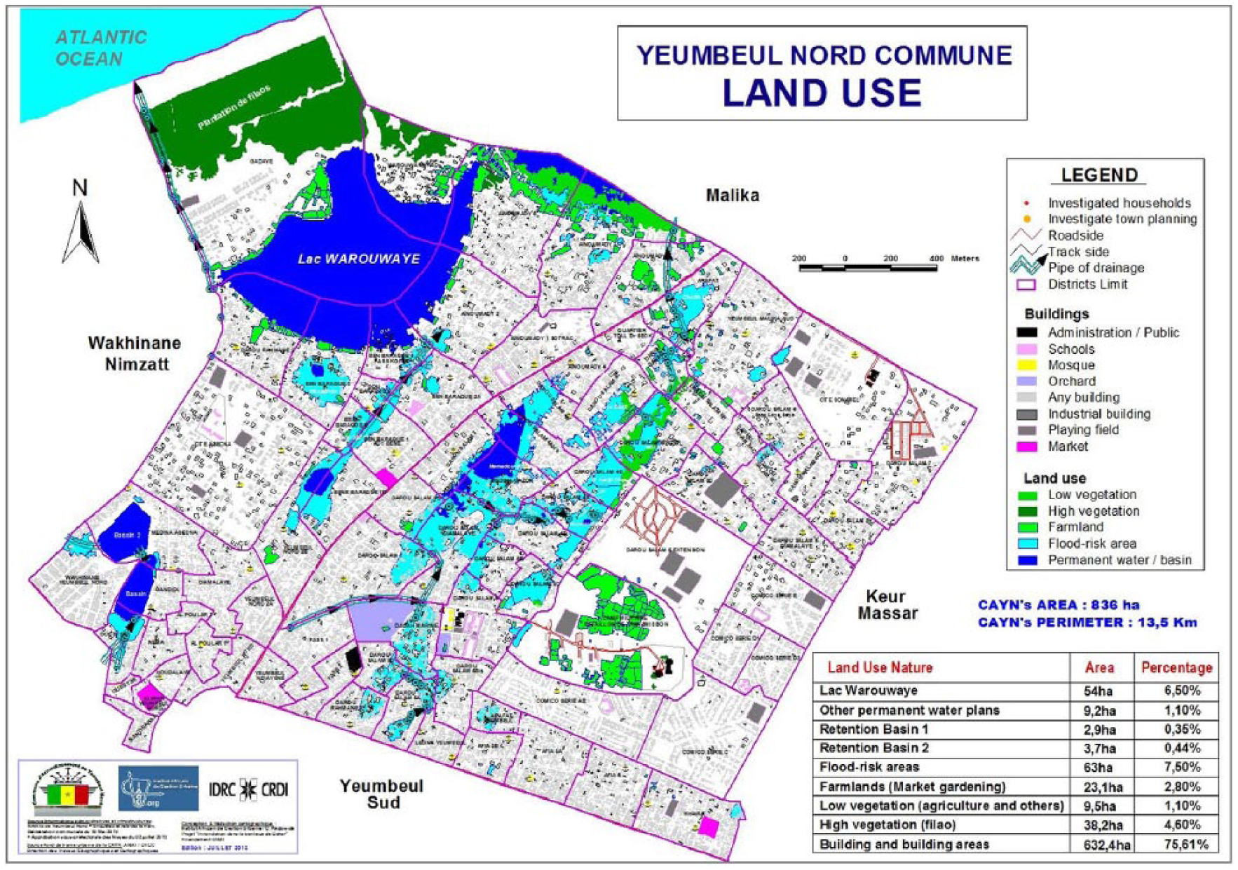
Map of Yeumbeul Nord municipality
The relief of the Yeumbeul Nord area features a series of dunes and depressions. Run-off water is concentrated in the lowest parts, where the black soil and availability of water make these areas suitable for market gardening.
Yeumbeul Nord had a population of 168,378 in 2013, up from 104,199 in 2002 – a rapid increase of 61.6 per cent in 11 years. This sharp rise in population, resulting from a significant flow of internal migrants, led to the establishment of new spontaneous settlements. By 2013, the population density had reached 20,141 per square kilometre, which is very high. By comparison, the Dakar region, where Yeumbeul Nord is located, and which has the highest density of any region in the country, has 5,739 per square kilometre. The region with the second highest density is Diourbel, with 311 per square kilometre.(8)
IV. Methods
The study adopted both qualitative(9) and quantitative methods. A literature search was also conducted, and various information sources were cross-checked. In agreement with the authorities of the Yeumbeul Nord municipality, a list of 25 flooded neighbourhoods was prepared. Exploratory visits helped to pinpoint neighbourhoods where the scale of the impact of flooding was most visible and significant, and 20 neighbourhoods were selected. Direct observation also served to identify flood-prone houses where the impact of flooding was still visible, so that these could be included if possible in the sample. Forty households were selected in each neighbourhood, and a questionnaire was administered to 800 respondents, each representing a household. The questionnaire addressed the household’s resources and characteristics; the impact of the floods on household and community resources; household and community adaptation strategies; community life; and people’s perceptions of rehousing policies and anti-flooding solutions.
Qualitative data were collected through focus group meetings and interviews with 38 people representing local stakeholders, institutions and public authorities.
The quantitative data from the questionnaire were processed using Sphinx software. Additional statistical analyses of data from the quantitative survey were carried out to establish correlations between the study variables. The chi-squared independence test was used for this purpose. QSR N6 qualitative data analysis software facilitated processing of the qualitative data, which were grouped into different nodes for the purpose of more in-depth analysis of the results of the quantitative survey.
V. Flooding and Rainfall in Senegal
Senegal has a Sudano-Sahelian type climate with a dry season and a rainy season, which usually lasts from June to October.(10)
Analysis of rainfall variation in Dakar during the period 1951–2000 shows the irregular nature of the succession of dry and wet periods (Figure 2). A net upturn in rainfall since 2005 could partly explain the flooding. Yet the annual amounts of rain recorded during the most serious flooding seen in Dakar in recent years were far from beating the previous record rainfall totals,(11) and flooding problems in the Dakar region must also be attributed to inadequacies in spatial planning.
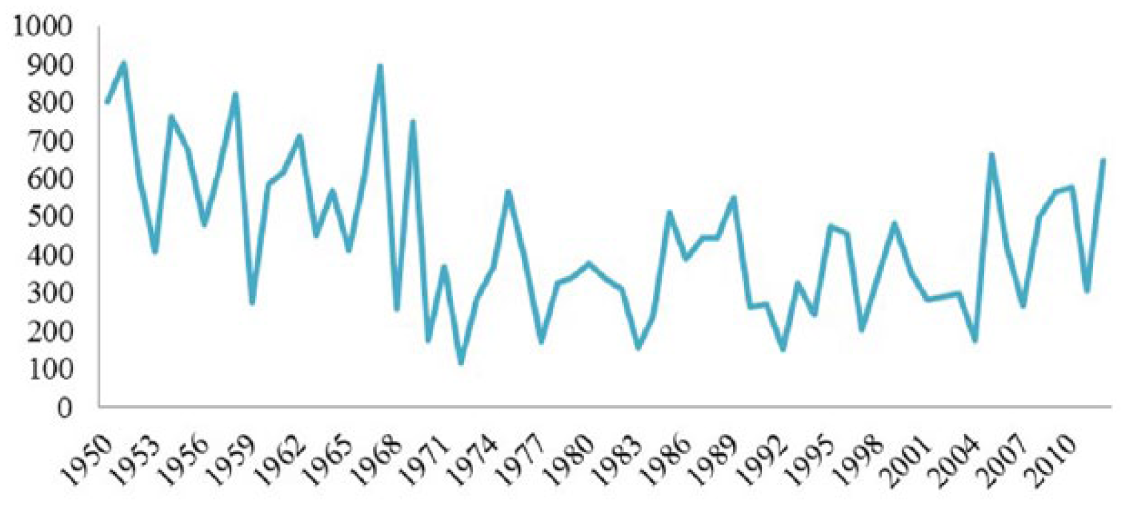
Variation in annual rainfall (in millimetres) in Dakar between 1950 and 2012
Records of annual rainfall in the Dakar region show that, in 2005, the year when flooding began in Dakar, there was an increase to 663 millimetres from the lower amounts recorded in the immediately preceding decades. Back in 1967, however, the capital had recorded annual rainfall of 895.4 millimetres, and in a number of years between 1950 and 1970, rainfall exceeded the amount that fell in 2005. Between 1970 and 2005, however, the capital did not record annual rainfall above 600 millimetres. In 2005, 2009 and 2012, when flooding occurred in Dakar, the rainfall average was 625.36 millimetres.
Beginning with the new upsurge in rainfall in 2005, and in particular in 2009 and 2012, Dakar suffered heavy flooding, sometimes in areas that had never been flooded before. These data back up the finding that the flooding was caused by a more significant amount of annual rainfall, despite the fact that this amount did not exceed earlier maximums.
Daily maximums appear stable, although there is a trend towards increasing intensity of rainfall for durations of 5 minutes, 10 minutes and 15 minutes.(12)
VI. Households and Housing Characteristics in the Flooded Neighbourhoods
Households in Yeumbeul Nord have an average of 11.18 members, higher than the national average of eight people per household in 2013 and the urban average of seven members, and almost double the average of six in the Dakar region.(13)
Only 12.8 per cent of household heads in Yeumbeul Nord are wage earners, and 63.5 per cent have no regular income. This illustrates the insecurity faced by most households living in flooded neighbourhoods and points to the informal nature of their income sources. It is not difficult to see why most turn to the informal market to access land. Only 40 per cent of heads of household have ever been to school, and of these about half have completed only primary or less. Fourteen per cent of household heads had secondary education and only 4.1 per cent higher education. Of the wage earners, 78 per cent have attended school, showing the extent to which the ability to earn a wage is determined by schooling.
a. Occupation of the neighbourhoods
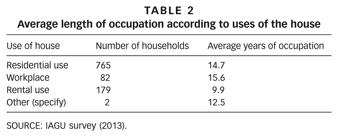
About 30 per cent of households have been living in their homes for less than eight years, i.e. since after the severe flooding in 2005 (Table 1), suggesting that flooding is not an obstacle to households occupying high-risk neighbourhoods. In fact, occupation has gone up in recent years, and these flood-prone sites in Yeumbeul Nord have been occupied more recently than one might have thought.
Number of years occupying the house

SOURCE: IAGU survey (2013).
b. Status and characteristics of housing
Over 80 per cent of households own their homes, a proportion that is very similar to the one shown in the Dakar Horizon 2025 Urban Master Plan.(14) Most of these owners (76.3 per cent of all households) have a deed of sale; only a small number have a permit to occupy (1.9 per cent) or a property title (0.4 per cent). This is indicative of informal appropriation of the site, which also means that most areas are unplanned, with no preliminary land preparation. This explains the absence of drainage and sanitation infrastructure.(15)
More than 80 per cent of houses have more than three rooms and over 40 per cent have more than five. This pattern, a response to the size of households, to a large extent explains people’s resistance to being rehoused at developed sites where they will only have three rooms. Because their income is irregular, they cannot access bank loans enabling them to build additional rooms quickly, and so are usually reluctant to move from their current homes to the resettlement areas.
c. Uses of houses
A substantial number of dwellings are used not only for residential but also for rental purposes and, to a lesser extent, as workplaces.
There is a significant relationship (p-value: p ≤ 0.01 per cent) between the average length of occupation and the uses to which houses are put (Table 2). Rentals are more common in houses occupied for 10 years or less, while older houses are more likely to be occupied by owners for either residential or workplace use. This is most likely because more recently built houses are designed with the flood risk in mind, and the buildings tend to be raised, which makes it more feasible for the property to be rented out.
Average length of occupation according to uses of the house
SOURCE: IAGU survey (2013).
VII. Impact of Flooding on Households’ Assets
a. Houses affected by flooding
In the flood-prone neighbourhoods surveyed, 50.9 per cent of houses were flooded in 2005, 65.4 per cent in 2012 and 72.6 per cent in 2009, the year when floods affected the largest number of households in the country.
The survey also revealed that 5 out of 800 houses were flooded in 2005 only, with increasingly large numbers experiencing flooding in 2009 and 2012 only. Still larger numbers of households were affected by more than one flood, with the greatest number being flooded all three times. It is clear that households are becoming increasingly vulnerable and that a household that has been flooded before is highly likely to suffer flooding again.
There is a relationship between flooding and the length of occupation (Table 3). Of the houses that have never been flooded, 45.6 per cent have been occupied for less than 10 years, compared to 29.5 per cent of houses occupied for 10–20 years and 24.3 per cent for more than 20 years. People who have lived in the neighbourhoods for less than 10 years are also less likely to have suffered from recurrent flooding. In other words, more recently built houses are less affected by flooding. They are built with flood risk in mind and are usually raised, which is not so easy for families with older houses. They are able to raise only some parts of the existing building or to put another storey on top.
Flood-risk status according to length of occupation of the flooded house
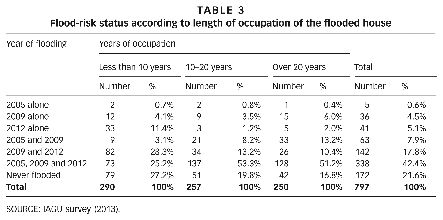
SOURCE: IAGU survey (2013).
b. Impact on household assets
Figure 3 shows the assets people have lost due to flooding.
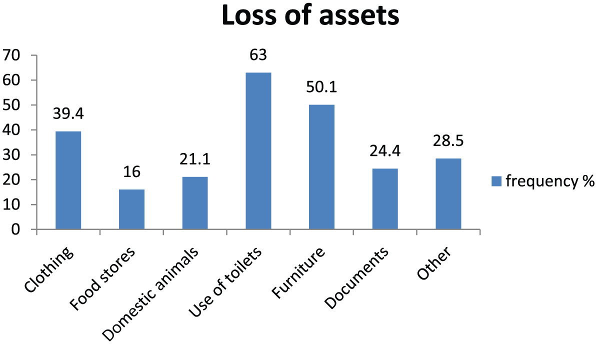
Percentage of households affected by loss of assets due to flooding
Floods are a major cause of destruction of assets. Figure 3 shows that 63 per cent of households lost the use of their toilet either temporarily or permanently. This is followed by the numbers that lost furniture and clothing, and the somewhat smaller numbers that lost administrative documents (diplomas, etc.) and domestic animals.
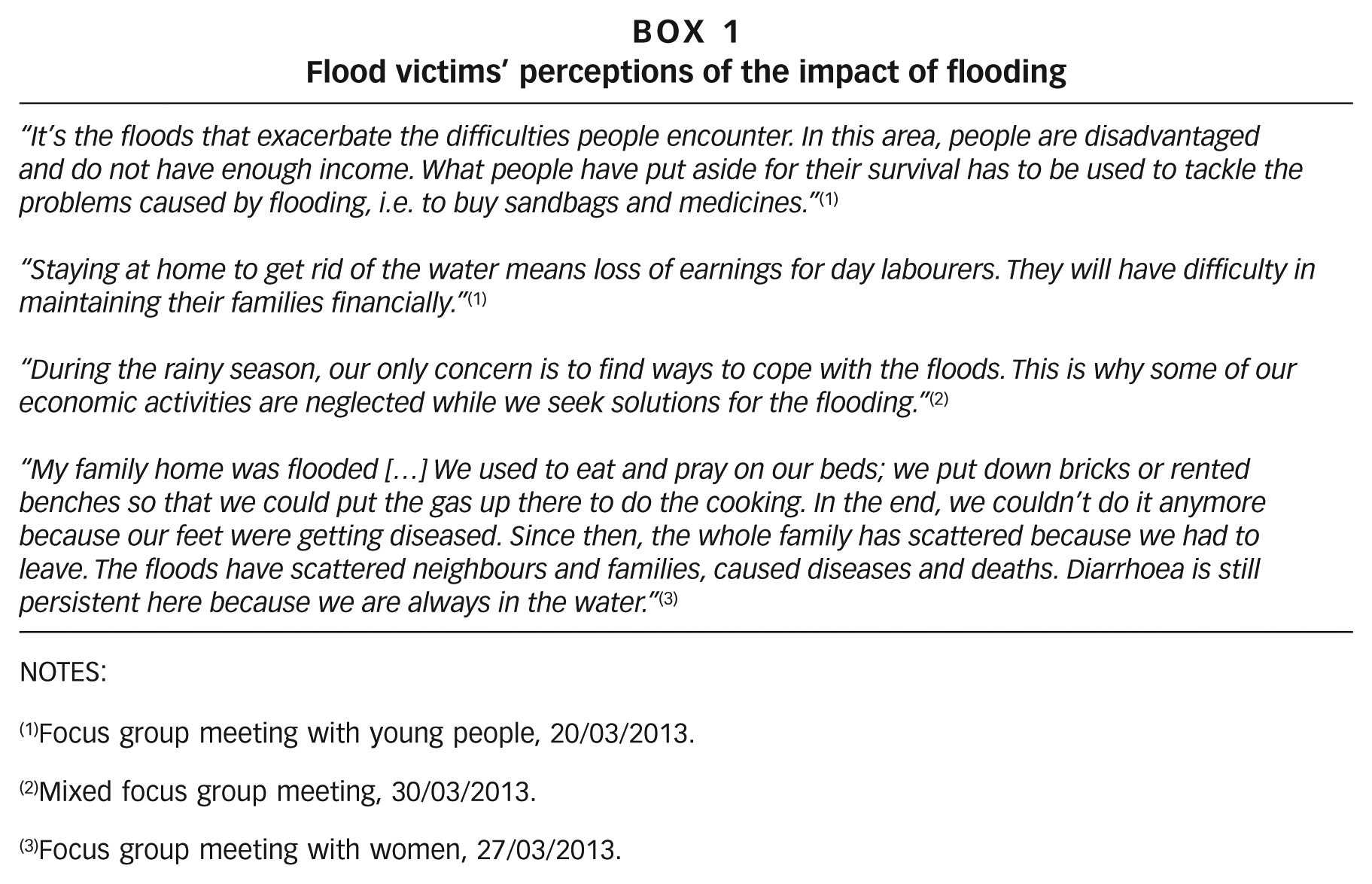
Flooding also affected the economic activities of 62.3 per cent of households in the flooded neighbourhoods, increasing the economic vulnerability of those who rely on their uncertain income. Time spent dealing with flooding means less time for income-generating economic activities. These activities are also disrupted because the public space in which they would normally be carried out is under water. The testimony of the flood victims reported in Box 1 illustrates the considerable impact of flooding on their lives.
c. Impact of flooding on houses
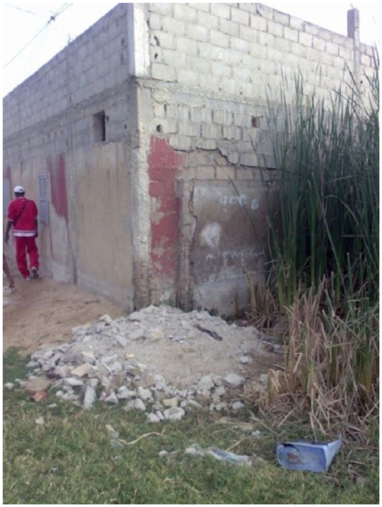
Houses have suffered different kinds of damage from flooding (Table 4). Persistent damp, even several months after the rainy season, is the foremost concern, followed by damage to paint in the houses. Cracks in buildings and toilet facilities filled with rainwater are also reported by the majority of households, and more than half reported warping of wooden doors and windows, which prevents them from being used properly. Houses are the main asset hit by flooding and this affects the majority of residents at the flooded sites. Even though they were less affected than those who were flooded, those who were not flooded did not escape damage from the rain. Almost all the flooded households suffered at least one form of damage, while 17 per cent of those not flooded had no damage. Photo 1 shows the damage to one house.
Damage suffered by houses
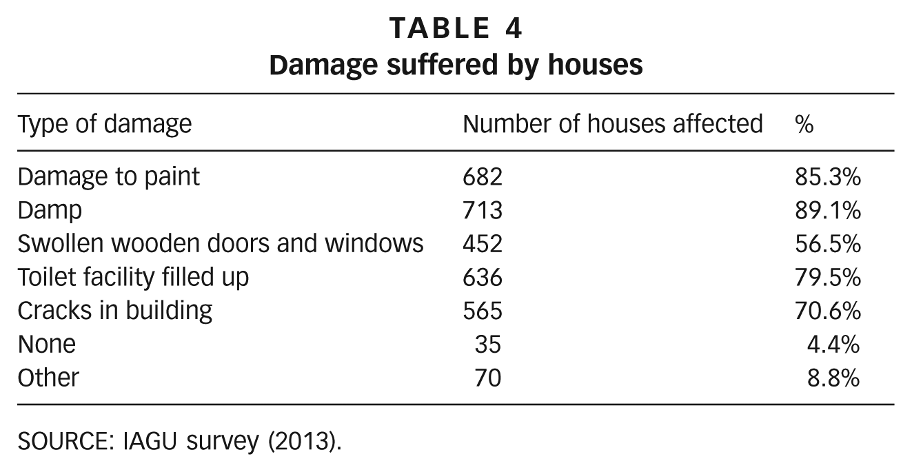
SOURCE: IAGU survey (2013).
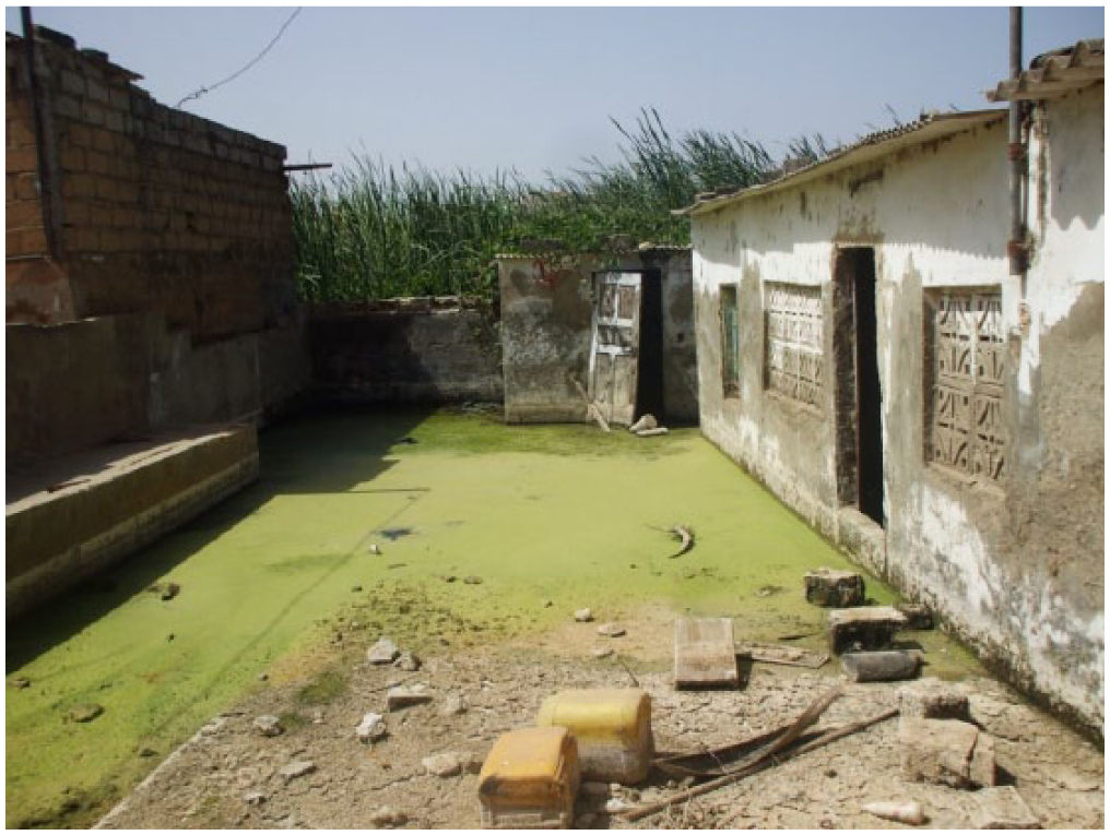
Flooded house in Yeumbeul Nord
d. Impact on toilet facilities
Almost 86 per cent of households reported toilet facilities to be affected by flooding. Household toilet facilities include septic tanks and sumps in 30.8 per cent of households and cesspits in 67 per cent, and respondents said that the rising water table was the main cause of their premature filling up and deterioration. The quality of construction may also have a bearing, because households design and install these facilities themselves.
Toilet facilities are far more likely to be affected in the case of houses that have been flooded (93 per cent affected) than those that have never been flooded (57 per cent affected). Cesspits rendered unusable by the rising water table and cesspits under construction that are higher than ground level are commonly seen in Yeumbeul Nord.
e. Impact on human and social capital
The floods also had a significant impact on health, children’s schooling, relationships among neighbours, and insecurity.
Health
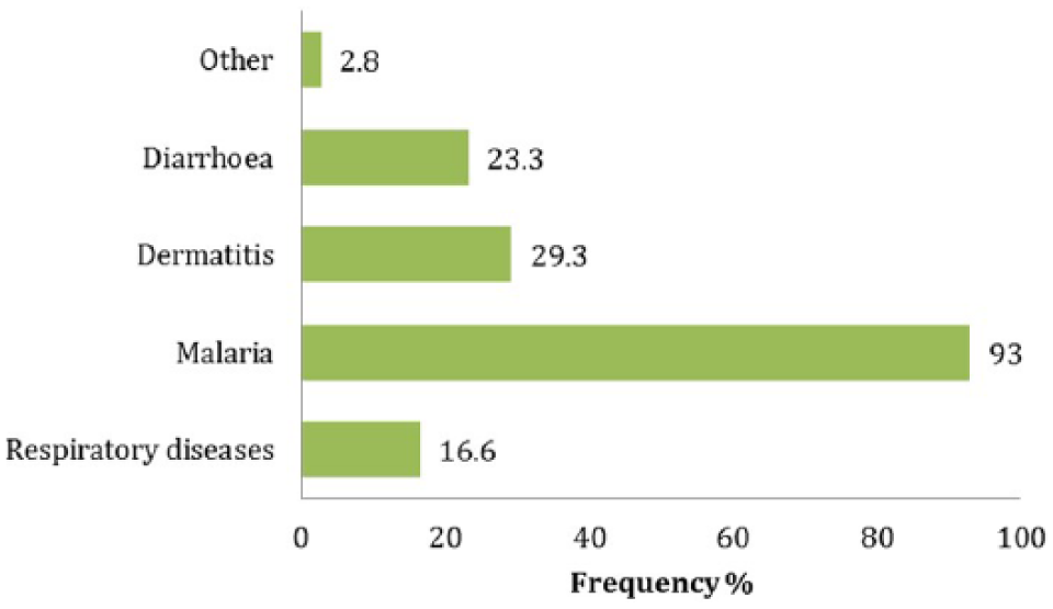
Flooding affects health throughout the community. Figure 4 provides an overview of morbidity during times of flooding, listing the most commonly seen diseases in Yeumbeul Nord. Although these ailments are not unique to flood periods, most (but not malaria) are intensified by flooding.
Commonly seen diseases
Malaria is by far the most common disease, with 93 per cent of households affected. Skin diseases come second, followed by diarrhoeal and respiratory diseases.
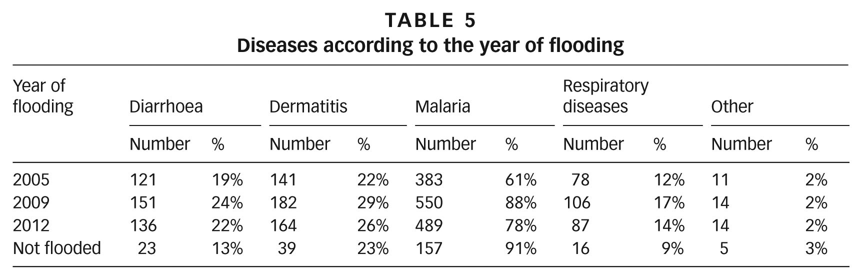
Those in unflooded houses are less affected by respiratory diseases and diarrhoea than those in flooded houses – 9 per cent and 13 per cent respectively compared to 17 and 24 per cent in 2009. Unflooded households were more affected by malaria than flooded ones in 2005, 2009 and 2012 due to the fact that malaria is environment based (Table 5).
Diseases according to the year of flooding
Children’s schooling
The surveys revealed that 53.1 per cent of households experienced the negative effect of flooding on their children’s schooling. Problems included getting to school on flooded streets and schools under water. According to a local councillor: “flooding influences the school results of our children and pupils are forced to travel to other places much further away. Under all these unfavourable conditions […] in addition to some families’ lack of resources, we see cases of school dropout. All schools in the Yeumbeul area have excess class numbers because some are flooded and no longer operational and this can influence pupils’ results.”(17) Flooding also has an impact on unflooded schools, which are obliged to take in children from the flooded schools and operate with very large classes. For example, the school in the Yeumbeul 3 SOTRAC neighbourhood has around 130 pupils in some classes, having taken in pupils from the Bara Fall school, which is still flooded. Any schools that escape flooding are also used to shelter the victims, and functioning classrooms have to cope with disrupted timetables.
Conflict
Almost 70 per cent of households acknowledge that flooding has given rise to disputes between neighbours around the flood prevention measures that people may adopt. For example, one resident declared that “activities to bank up alleyways and drain off water do not suit everyone because the water diverted in this way can flood the neighbours and cause disputes between local people or even between neighbourhoods.”(18)
Insecurity
Many houses have been abandoned (Photo 2) because of flooding and as a result have been taken over by thieves, thugs and other criminals. A rise in the number of rapes and assaults is attributed largely to this proliferation of abandoned houses. According to one local councillor, “Yeumbeul Nord is the stronghold of criminals because the abandoned houses provide refuge for criminals and this is why we are seeing an upsurge in assaults”.(19)
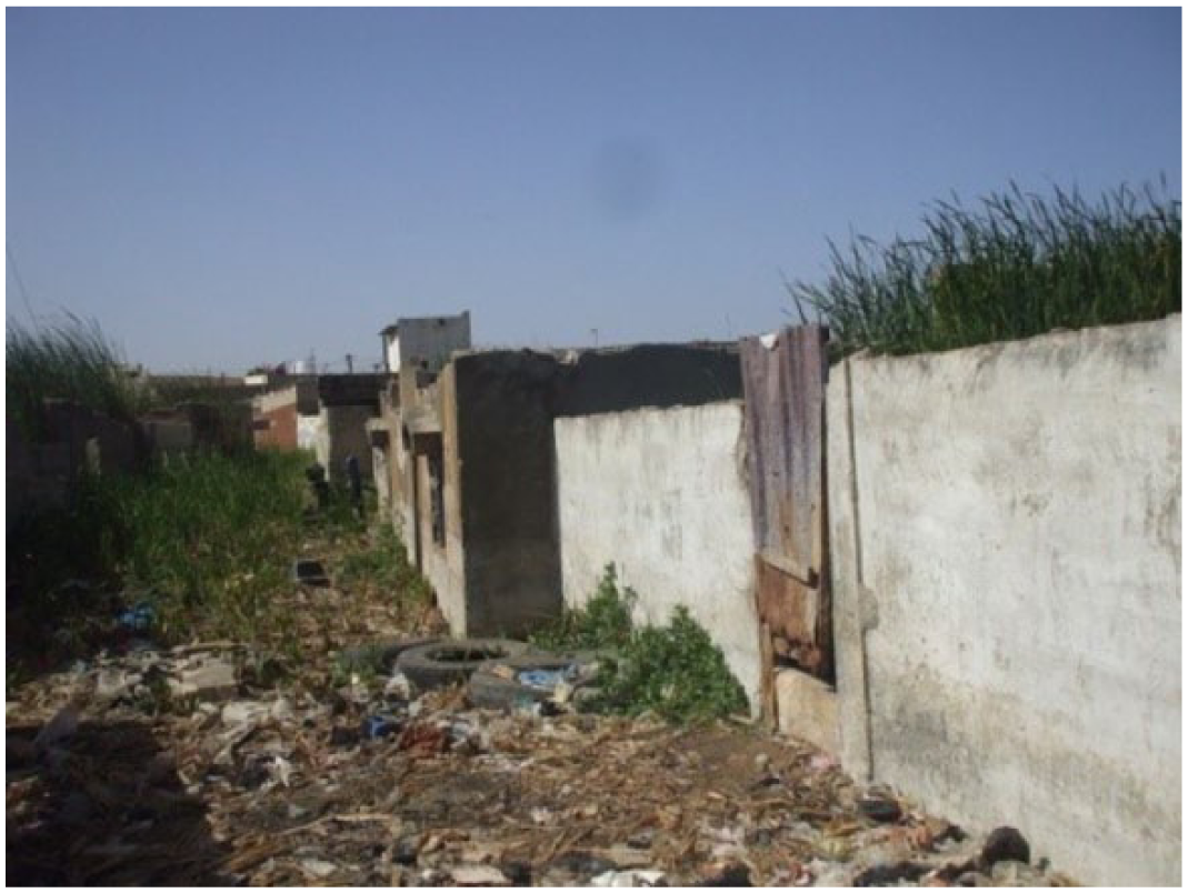
Abandoned house in Yeumbeul Nord
VIII. Household and Community Adaptation Strategies before, During and after the Floods
Adaptation can be seen as a regressive process that, when applied to environmental phenomena such as flooding, requires the deployment of (tangible or intangible) resources in order to avoid suffering the consequences. Adaptation strategies are designed to address not so much the causes of these phenomena as their consequences for vulnerable (physical or human) systems. They can only be dynamic and flexible if they follow the rhythm and demands imposed by the phenomena and the means available to those preparing the strategies. An evaluation report by the Senegalese government on post-flooding needs in 2010 showed that 30,000 compounds were affected in the Dakar region, and that most flood victims were poor and suffered repercussions from the impact on their usual informal economic activities.(20) According to sociologist Abdou Salam Fall, however, the poor are not simply “victims of their destiny” but also “lively, resourceful people always in the process of tinkering away to survive”. He recognizes that they have a “series of strategies to improve their lives and protect themselves against threats […]”.(21)
a. Asset-based adaptation strategies adopted by households before, during and after the rains
Table 6 lists asset-related actions taken by households before, during and after the floods.
Action taken by households before, during and after the rains
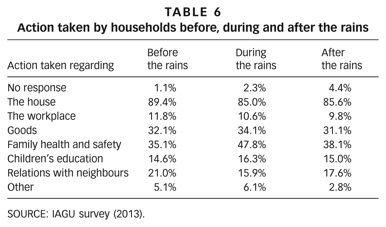
SOURCE: IAGU survey (2013).
Most households take action regarding their houses before (89.4 per cent), during (85 per cent) and after (85.6 per cent) the rains. Action with regard to family health and security comes in second place and is most prevalent during the rains, followed by action after and before the rains. The extent of water stagnation during the rains and the resulting malaria could explain this difference. Households take slightly more action to protect their goods during the rains than before and after the rains. Between 15 and 21 per cent of residents take action to improve relations with other neighbourhood residents or to secure their children’s education before, during and after the rains. Action taken during the rainy season also depends on the length of time the house is flooded.
b. Adaptation strategies related to housing and floodwater before, during and after the rains
Action taken regarding the house is always related to flood-risk status. People whose houses were not flooded account for about 20 per cent of those taking action. Households that were flooded in 2009 took more action regarding their houses than those flooded in other years, most likely an indication of the severity of the flooding seen that year.
The most significant adaptation strategies adopted in relation to floodwater are listed in Table 7, which shows that the most repeated activities during the three periods (before, during and after flooding) are banking up, manual water removal, pumping, drainage and raising of buildings.
Household adaptation strategies in relation to floodwater undertaken before, during and after the rains
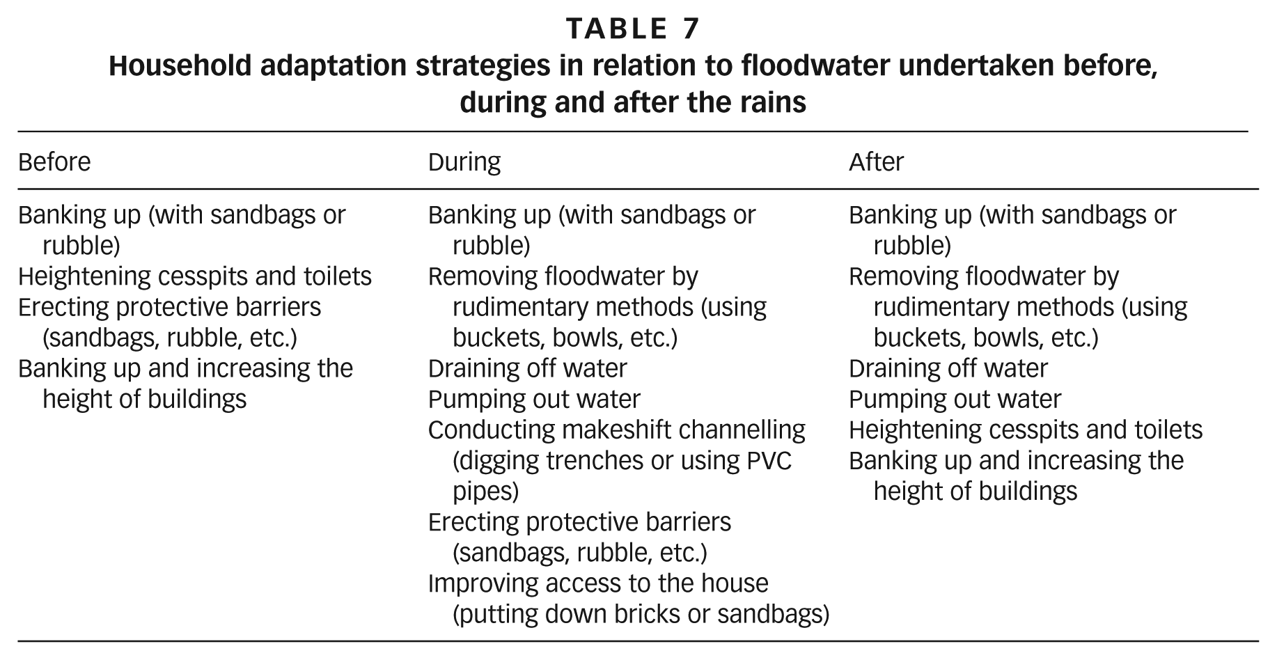
Banking up
People adopt this technique before, during and after the floods, using sandbags or rubble to absorb stagnant water, to get around, or to raise houses or the lower parts of flooded or flood-prone houses. The fact that banking up is the main technique used by people to prevent or combat flooding does not mean that it is effective. Banked-up streams and roads raise the level of the ground and the resulting unevenness can mean that further work is needed on the buildings. This practice heightens the roads and captures the water inside houses. In the longer term, households are forced to demolish and rebuild by heightening parts of their buildings.
Successive banking up of roads eventually reduces the size of house entrances and brings the ground up to window level. By dint of continual banking up, houses end up no longer being high enough for use as living space. The strategy adopted to cope with this situation, as shown in Photo 3, consists of removing the floor or roof and increasing the height of the building before redoing the floor or roof. All these structural modifications can affect the building’s stability and resistance.
Banking up a house and increasing its height
Removing the floodwater
Removing the water is a common means of coping with flooding. It is generally achieved by pumping out the water, draining it off in trenches or PVC pipes, or using other means available to households (Photos 4 and 5).
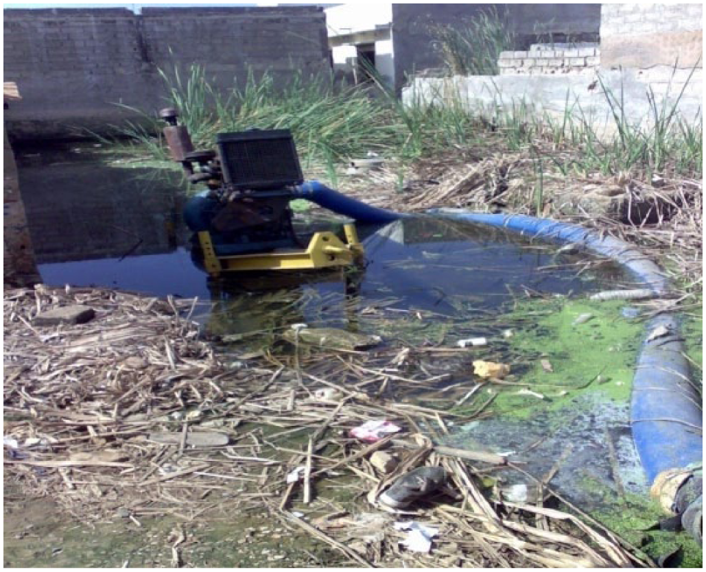
Rainwater pumping engine in Yeumbeul Nord
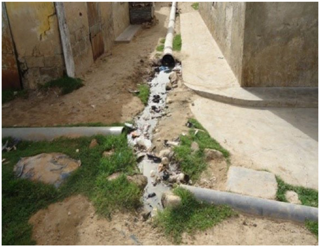
PVC pipes in Yeumbeul Nord
Repairs to houses
The most substantial flood damage (61 per cent) affects houses, which is also a major source of loss (18 per cent), second only to trade.(22) It is therefore understandable that they should be a priority asset targeted by household adaptation strategies. The impact of flooding on housing forces households to undertake certain repairs and improvements, the most significant of which are listed in Table 8.
Improvements to houses
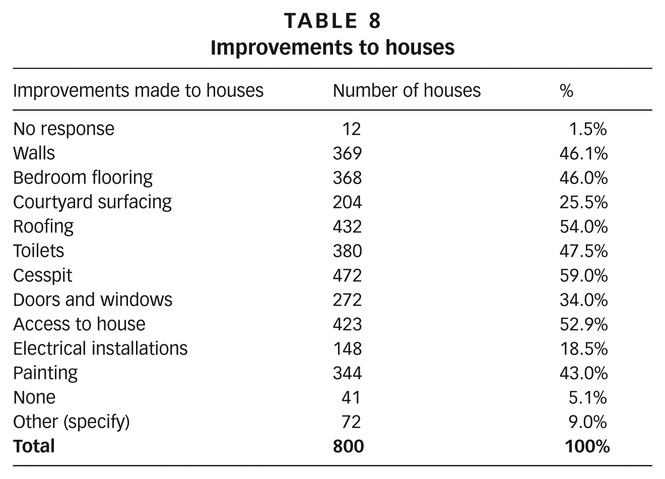
Improvements to cesspits are most common, involving 59 per cent of households, followed by roofing, access to the house, toilets and walls. Bedroom flooring and painting come next.
Adaptation strategies for toilet facilities
Toilet facilities are particularly vulnerable due to the influence of the water table, and 85.6 per cent of households acknowledge that flooding affects their cesspits and septic tanks. Groundwater fills up the cesspits by infiltration and the most common strategy consists of raising cesspits and toilets. Photo 6 illustrates this type of adaptation.

Raising toilet facilities
Photo 6 shows a septic tank well above ground level so that groundwater can no longer easily fill them up. Some households opt to use more impermeable septic tanks made of PVC (Photo 7).
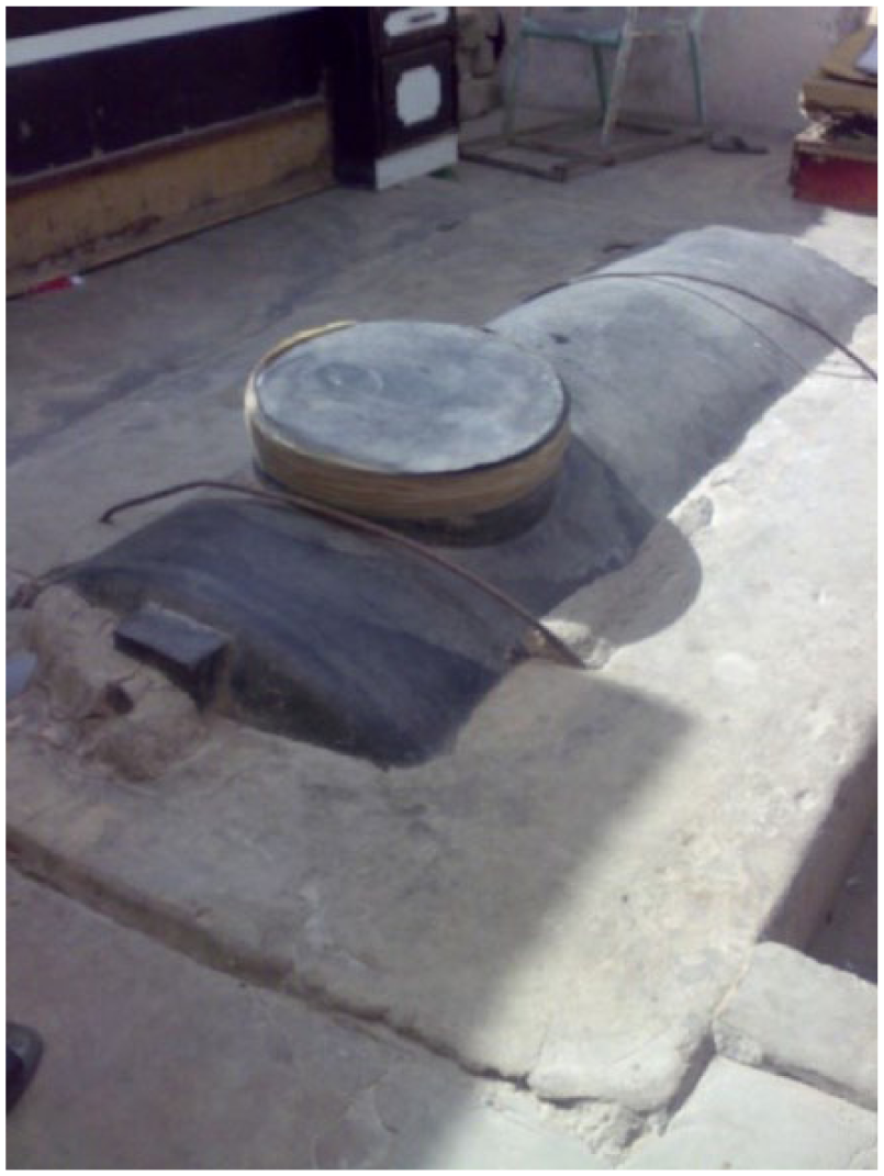
PVC septic tank
The household that uses the PVC septic tank shown in Photo 7 used to have its cesspit emptied every month but can now wait an average of three months before having the tank emptied.
IX. Solutions Advocated by Households
a. Households’ position concerning rehousing
Rehousing in other neighbourhoods that are not flood-prone is accepted by the majority of affected households when it is offered. However, despite repeated flooding and its heavy social cost, almost a third still prefer to stay at their current site. There is even greater reluctance to be resettled at a site specifically for flood victims.
This reluctance appears to stem from the features of the proposed resettlement sites and housing (number of rooms, lack of income-generating activities), the cost of being rehoused (households have to reimburse part the cost), the stigmatization of relocation sites for flood victims, etc. Rehousing is also impeded by the strong attachment of households to the flooded areas.
b. Households’ position concerning redevelopment of neighbourhoods
There has been intense debate for some years concerning rehousing versus the redevelopment of flood-prone neighbourhoods. Over 80 per cent of households think that it is possible to redevelop their neighbourhoods. This does not conflict with the finding that households also approve of rehousing. They would accept offers of rehousing but are still convinced that the flooded neighbourhoods can be redeveloped.
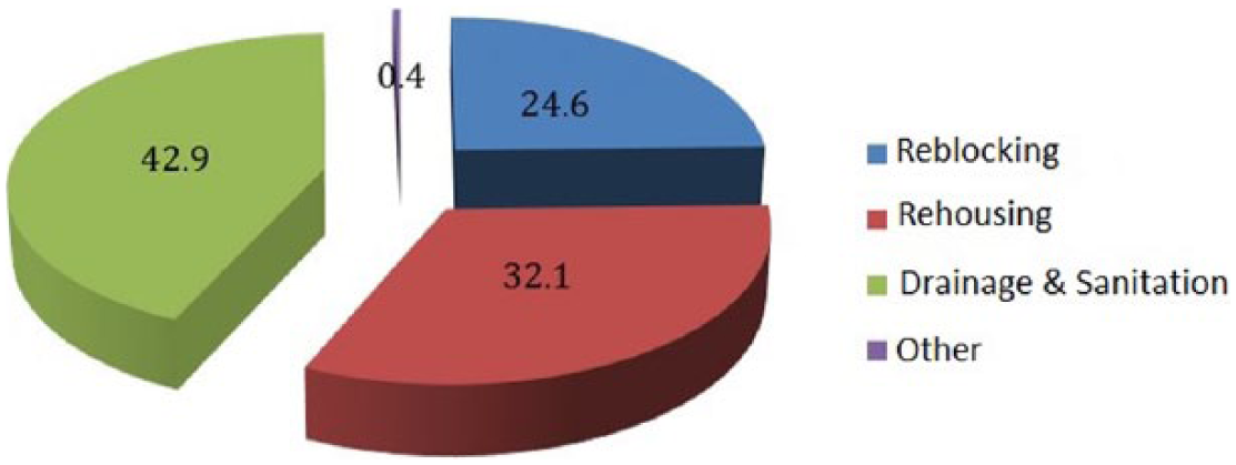
c. Solutions advocated: reblocking, rehousing, drainage/sanitation
The main solutions advocated by local people to deal with the impacts of flooding are rehousing of affected families, reblocking of the neighbourhoods (moving buildings in order to create space for streets and infrastructure) and sanitation/rainwater drainage.
Figure 5 shows that over 40 per cent of households advocate the installation of drainage and sanitation as the preferred solution for recurrent flooding, According to one local councillor, “There is flooding quite simply because there is no system for draining off rainwater”.(23) People feel that the flooded neighbourhoods could be saved if they were equipped with a rainwater drainage system. For some, the first step is to reblock the neighbourhoods and open up roads, along with introducing a rainwater drainage system. However, they would not reject rehousing if it were to be implemented. A third see rehousing as the preferred option, although a majority see rehousing as an acceptable alternative, ideally in other neighbourhoods that are not flood-prone if that option is chosen by the public authorities. They are less keen on rehousing at resettlement sites for flood victims.
Solutions advocated by households
X. Conclusions
Disadvantaged communities in the suburbs of Dakar in general and Yeumbeul Nord in particular have suffered from recurrent, large-scale flooding over the last 10 years or so, which continually undermines their precarious resources. As they have neither regular income nor formal ownership title to their houses, uneducated heads of household in the flood-prone neighbourhoods of Yeumbeul Nord struggle to remove their families from insecurity and poverty. The impacts of flooding on families in the neighbourhoods of Yeumbeul Nord are all the more burdensome because these unplanned areas are densely populated. The municipality of Yeumbeul Nord is 3.5 times more densely populated than the Dakar region and the average household in Yeumbeul Nord is twice as large.
Flooding does not prevent households from occupying high-risk neighbourhoods, however, and occupation of the wetland areas continued long after the drought periods of the 1970s were over. This more recent occupation of the flood-prone sites in Yeumbeul Nord even offers the advantage of being more affordable because of the flood risk. This more recent arrival at the flood-prone sites, knowing the risk, enables people to take better account of flooding when they settle and build houses. More recently constructed houses are raised and are less affected by flooding.
Flooding is a major cause of destruction of assets. The main household assets affected include toilets, furniture, clothing, administrative documents (diplomas, etc.) and domestic animals. A huge concern is the filling of toilets and cesspits with groundwater.
Flooding increases the economic vulnerability of households, who need their uncertain income to boost their resilience. Time spent dealing with flooding means less time for income-generating activities, which are also disrupted because the public space in which they would normally be carried out is under water.
Houses suffer considerable damage as a result of repeated flooding. Damp is a problem affecting most houses along with cracks, paint damage, warping of doors and windows, and filling up of cesspits. Nor does flooding spare people’s health, with malaria affecting most households. People also suffer from skin problems and diarrhoeal and respiratory diseases. Flooding affects schools and children’s schooling; schools are flooded along with the roads leading to them, and functioning classrooms have to cope with excessive numbers of pupils. Flooding increases the number of disputes between neighbours and brings insecurity into the neighbourhoods.
People do not remain inactive and resigned under the circumstances. They develop a wide range of strategies before, during and after the rains to safeguard their houses, preserve their families’ health and safety and their goods, strengthen relations with their neighbours and ensure their children’s education.
People mostly resort to banking up with sand, rubble or even rubbish to prevent the ingress of water, but such practices can have the effect of worsening flooding in the longer term. They also erect protective barriers (sandbags and rubble); dig drains (trenches) or use PVC pipes; put down bricks or sandbags to improve access to their houses; or pump out the water.
Safeguarding the quality of their homes is the main concern of people in the flooded neighbourhoods. Families undertake various improvements to tackle damage to their houses. Work most commonly involves toilets and septic tanks, which are raised to escape water infiltration or replaced by more impermeable PVC septic tanks. Improvements are also made to roofing, access to houses, walls and bedroom flooring.
Only one-third of households advocate rehousing as the preferred solution to repeated flooding. The majority suggest improved drainage in some cases along with reblocking, i.e. redevelopment of the neighbourhoods. However, the majority would not reject rehousing if it were to be implemented.
People are less keen on rehousing at resettlement sites for flood victims, largely because the three-room houses at the resettlement sites for flood victims cannot accommodate the large families from the flooded neighbourhoods.
The information derived from this participatory study points to various recommendations for authorities. To improve the efficiency and viability of household adaptation strategies, the state and municipalities need to offer help with building techniques appropriate to flood-prone areas. The authorities should set up awareness-raising programmes in partnership with local stakeholders, aimed at discouraging the practice of banking up, which exacerbates flooding in the medium and long term. The state should encourage micro-finance institutions to establish credit facilities to finance small-scale adaptations to houses. As part of the 10-Year Flood Management Programme (2012–2022), special emphasis should be placed on rolling out efficient, independent toilet facilities. Restructuring and redevelopment of flooded neighbourhoods should be a priority for the public authorities, and rehousing at other sites should primarily target houses that are in the way of building drainage and water storage systems. Rehousing for beneficiary families should also provide sufficient rooms for the large households in most flooded houses.
Footnotes
1.
Dacosta, H, R N Diouf and A Kane (2010), “Variabilité pluviométrique à Dakar : Du pluriannuel à l’infrahoraire” [“Variability of rainfall in Dakar: From the multiannual to the minute-by-minute”], Paper presented at the scientific conference on the theme “Les inondations à Dakar : Mieux comprendre les causes pour des solutions durables” [“Floods in Dakar: To better understand the causes for durable solutions”], organized by l’Amicale des Diplômés de l’École Polytechnique de Thies (ADEPT) on 11–12 June 2010 at Centre Africain d’Etudes Supérieures en Gestion (CESAG), Dakar.
2.
Mbow, C, A Diop, A T Diaw et al. (2008), “Urban sprawl development and flooding at Yeumbeul suburb (Dakar-Senegal)”, African Journal of Environmental Science and Technology Vol 2, No 4, pages 075–088.
3.
“Vulnerability has an external side – exposure to hazard – and an internal side – difficulties in coping or recovering following a shock”. Bohle, H-G (2001), “Vulnerability and criticality: perspectives from social geography”, IHDP Update 2/2001, Newsletter of the International Human Dimensions Programme on Global Environmental Change, pages 1–7; also Wisner, B (2002), “Who? What? Where? When? In an emergency: notes on possible indicators of vulnerability and resilience by phase of the disaster management cycle and social actor”, in E Plate (editor), Environment and Human Security: Contributions to a Workshop in Bonn, 23–25 October 2002, pages 12/7–12/14. Cited by Becerra, S (2012), “Vulnérabilité, risques et environnement: l’itinéraire chaotique d’un paradigme sociologique contemporain”, VertigO-la revue électronique en sciences de l’environnement [Online], Vol 12, No 1, accessed 7 November 2012.
4.
Moser, C, A Norton, A Stein and S Georgieva (2010), ”Pro-Poor Adaptation to Climate Change in Urban Centers: Case Studies of Vulnerability and Resilience in Kenya and Nicaragua”, World Bank, Sustainable Development Network, Social Development Department, Washington, DC, 96 pages.
5.
![]() , Managing the Risks of Extreme Events and Disasters to Advance Climate Change Adaptation, Special Report of Working Groups I and II of the Intergovernmental Panel on Climate Change [Field, C B, V Barros, T F Stocker, D Qin, D J Dokken, K L Ebi, M D Mastrandrea, K J Mach, G-K Plattner, S K Allen, M Tignor and P M Midgley (editors)], Cambridge University Press, Cambridge, UK, and New York, NY, USA, 582 pages.
, Managing the Risks of Extreme Events and Disasters to Advance Climate Change Adaptation, Special Report of Working Groups I and II of the Intergovernmental Panel on Climate Change [Field, C B, V Barros, T F Stocker, D Qin, D J Dokken, K L Ebi, M D Mastrandrea, K J Mach, G-K Plattner, S K Allen, M Tignor and P M Midgley (editors)], Cambridge University Press, Cambridge, UK, and New York, NY, USA, 582 pages.
6.
Jackson et al. (1972) have long stressed the multi-dimensional aspect of risk, by virtue of which exposure to uncertainty may be physical, but also financial, ethical or social. Jackson, D N, B Hourany and N J Vidmar (1972), “A four-dimensional interpretation of risk taking”, Journal of Personality Vol 40, No 3, pages 483–501. Cited by Soulé, B and J Corneloup (2007), “La conceptualisation en sociologie : influences paradigmatiques et implications méthodologiques”, Bulletin de méthodologie sociologique Vol 93 [Online], accessed 13 November 2012 at ![]() .
.
7.
See reference 4.
8.
9.
Concerning the qualitative method, “The knowledge produced can be no more than plausible approximations, […] while the ideal survey, if there is such a thing, should obviously combine qualitative and quantitative and there can be no question of setting one against the other”. Olivier de Sardan, J-P (2008), La rigueur du qualitatif. Les contraintes empiriques de l’interprétation socio-anthropologique, Louvain-La-Neuve, Academia-Bruylant, 368 pages. Cited by Cissé, R (2012), La transmission intergénérationnelle de la pauvreté au Sénégal : Entre récurrence, rupture et résilience dans les trajectoires des pauvres, PhD thesis, Université Cheikh Anta Diop de Dakar, 369 pages.
10.
See reference 8.
11.
See reference 1.
12.
See reference 1.
13.
See reference 8.
14.
Ministère de l’Urbanisme, de l’Habitat, de l’Hydraulique et de l’Assainissement (2006), Plan Directeur d’Urbanisme de Dakar “Horizon 2025” – Rapport Définitif.
15.
See reference 14, page 137.
16.
The survey was conducted in 2013 by IAGU during a research study supported by IDRC (International Development Research Centre – Canada) on the Impacts and Adaptations Strategies to Floods of the Households in the suburbs of Dakar. This field survey was done through 800 households from the 20 most flooded wards among 81 of the Yeumbeul Nord Commune. 40 households were selected from each of the targeted ward. Quantitative datas were collected from the survey. The results will be published in 2016 by Karthala (France) in a collective book which will also include additional chapters issued from the other themes addressed by the research in Yeumbeul Nord and other studies on flooding from different communes in the suburb of Dakar.
17.
Focus group meeting with councillors, 02/04/2013.
18.
See reference 17.
19.
See reference 17.
20.
![]() , “Rapport d’évaluation des Besoins Post Catastrophe. Inondations urbaines à Dakar en 2009” [“Evaluation report of post-disaster needs: Urban flooding in Dakar in 2009”], Report prepared by the government of the Republic of Senegal with support from the World Bank, UN system and the European Commission, Final report, June, 191 pages.
, “Rapport d’évaluation des Besoins Post Catastrophe. Inondations urbaines à Dakar en 2009” [“Evaluation report of post-disaster needs: Urban flooding in Dakar in 2009”], Report prepared by the government of the Republic of Senegal with support from the World Bank, UN system and the European Commission, Final report, June, 191 pages.
21.
Fall, A S (2007), Bricoler pour survivre : perceptions de la pauvreté dans l’agglomération urbaine de Dakar [Tinkering to survive: perceptions of poverty in the urban agglomeration of Dakar], Editions Karthala, Paris.
22.
See reference 17.
23.
See reference 17.