
Abstract
Eyes in the sky watching for weapons work

Negotiations on an international treaty to end the production of fissile materials for weapons (sometimes called the “fissban treaty”) have been stalled for years. And the situation is unlikely to change soon, given the U.S. plan to build a national missile defense—a great concern to countries including China that are key players in the negotiations.
Nonetheless, the U.S., Russian, British, and French governments have all announced that they have ended fissile material production, and Chinese experts have quietly put out the word that China has had a production moratorium since approximately 1991. The United States and others have pressed Israel, India, and Pakistan—the three de facto nuclear states—to join in the moratorium, but those countries have failed to do so.
In the absence of a treaty, two questions arise. Is it possible to rely on statements declaring a production moratorium? Or is there evidence that would offer some additional assurance that fissile material production has in fact been halted? We don't believe that any strategy could replace on-site international inspections. However, civilian imaging satellites can provide confirmatory evidence that some important types of fissile-material production facilities have been shut down.
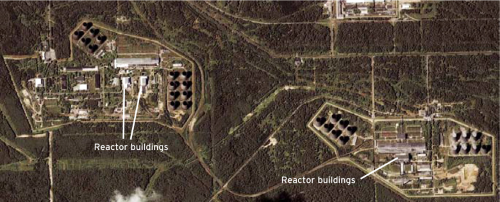
This Ikonos image of Russia's Tomsk-7 plutonium-production site, taken July 10, 2000, reveals two distinct areas, each with a pair of plutonium-production reactors. The most noticeable structures in each area are the large natural-draft cooling towers. The vapor escaping from six of these cooling towers (lower right) is a telltale sign that the reactors are operating. In fact, it is known that both of the reactors in this area continue to operate—although probably only one was operating on this particular summer morning. The two reactors in the area to the left were decommissioned in 1990 and 1992.
In some cases, arrangements for on-site transparency are in place. The United States and Russia, for example, have a bilateral agreement under which they can inspect each other's shut-down plutonium-production reactors. This is part of a deal under which the United States is committed to help Russia replace the heat and electricity provided to nearby cities by the three still-operating plutonium-production reactors at Tomsk-7 and Krasnoyarsk-26. The two countries should make a similar agreement for reciprocal or International Atomic Energy Agency (IAEA) on-site inspections to verify that they have ended their production of highly enriched uranium. Such an agreement could be linked to the approximately $10 billion commitment that the United States has made to purchase 500 tons of Russia's excess weapon-grade uranium, which is being “blended down” for use as power reactor fuel.
Many British and French demilitarized fissile-material production facilities have already been placed under Euratom and IAEA safeguards. In China, Israel, India, and Pakistan, however, international access is not yet available.
We therefore decided to see how much information about the operating status of nuclear-material production facilities could be gleaned from non-intrusive, commercial satellite images. In many cases, these images provide useful information.
What we looked at
Gaseous diffusion plants use huge amounts of energy. France, for example, built a nuclear power plant with four large reactors to supply the Eurodif gaseous diffusion plant with electrical power. Just as with reactors, therefore, the operations of gaseous diffusion plants can be inferred from the visible manifestations of their cooling-water requirements.
China and the United States also operate gaseous diffusion plants. But Russia, Britain, and Pakistan operate centrifuge enrichment plants. These plants are much more energy efficient and therefore do not require highly visible cooling arrangements. Both Israel and India have reportedly carried out research and development on centrifuge enrichment, but there is no public report that they have yet produced significant amounts of weapon-grade uranium.
New tools
Since the 1960s, the United States and the Soviet Union/Russia have used spy satellites to identify and monitor foreign nuclear facilities and activities. In 1995, U.S. spy satellite images from 1960 to 1972 were declassified. These images ranged in resolution down to about two meters.
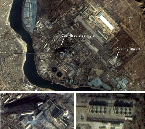
This Ikonos image of China's gaseous diffusion plant near Lanzhou in central China reveals a bank of mechanicaldraft cooling towers (see enlargement, lower right) with no trace of vapor. Nearby is a coal-fired plant with visible plumes of steam (enlargement, lower left). More than one image would be required to confirm that this plant is shut down, but the image is consistent with reports that the Lanzhou plant was closed after sufficient energyefficient centrifuge capacity was built at other locations. China's centrifuge plants were supplied by Russia. As a condition of the supply agreement, the plants must be monitored by the IAEA to verify that they are not producing highly enriched uranium. Verification that China's gaseous diffusion plants are not operating, in combination with IAEA inspections of China's centrifuge plants, would confirm that China is not producing weapon uranium.
The current generation of U.S. spy satellites is reportedly able to identify objects on the ground as small as 10 centimeters. Resolution is defined as the size of the area on the ground imaged on a single pixel on a solid-state sensor array at the focal plane of the satellite camera.
Images with resolutions of 10 to 30 meters have long been available from French spot and U.S. Landsat imaging satellites. In 1999, however, images with a resolution of one meter became commercially available from Space Imaging's Ikonos satellite. One-meter images became available from Russian satellites in mid-2000, and other companies are expected to enter the market soon. A U.S. company, EarthWatch, plans to launch the “QuickBird” satellite with a 0.6-meter resolution in October 2001; Space Imaging plans to launch a satellite with 0.5-meter resolution in 2004.
An Ikonos image of China's first plutonium-production reactor in the Jiuquan complex in northwest China shows no vapor plumes from its large natural-draft cooling towers. This is consistent with reports that the reactor was shut down in 1984.
Israel's Dimona reactor has a small mechanical cooling tower with two fan vents. A July 4, 2000 Ikonos image is displayed on the Federation of American Scientists (fas) web site (www.fas.org). However, the Kyl-Bingaman amendment to the National Defense Authorization Act of 1997 bars U.S. companies from releasing satellite images of Israel that are of a higher resolution than those available from foreign commercial vendors. This image of Dimona was therefore degraded to a 2-meter resolution before it was released. We believe that even at this resolution, we can see vapor plumes rising from the two vents. Unfortunately, because the air is very dry in Dimona, the plumes are wispy and difficult to evaluate. Images with a 1-meter resolution may be released soon.
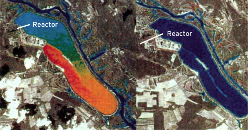
Two Landsat-5 false-color thermal-infrared images of the Chernobyl cooling pond, taken before and after the April 26, 1986, accident. On April 22, 1986 (image on left), the lake surface is several degrees warmer in the orange area due to the discharge of hot water. On May 8, 1986, no hot water is being discharged because the reactors have been turned off. (Source: United States Army Multispectral Imagery Product Guide, Second Edition, ATC-IA-2681-030-94, May 1994.)
A February 2000 Ikonos image of Pakistan's new plutonium-production reactor at Khushab can be found on both the fas site and the Institute for Science and International Security site (www.isis-online.org). This reactor is comparable in power to the Dimona reactor, and the image has not been degraded. If there is a vapor plume, it is very difficult to see. Images from several passes would need to be analyzed to determine the influence of atmospheric humidity and how the plume looks when the reactor is operating.
Thermal plumes and hot water
It has long been known that the plumes of hot water from large power plants dumped into rivers, lakes, or estuaries are highly visible at thermal infrared wavelengths—even at low resolutions. Perhaps the most dramatic images of this type are false-color images of the lake-sized cooling pond associated with the Chernobyl reactors taken before and after the April 26, 1986, accident. In the images, red indicates the hottest temperatures and shows where the water is discharged; blue indicates the cooler water near the intake channel. The straight line in the middle of the lake between the hot and cool water is a dike channeling the hot water toward the end of the lake away from the intake. On May 8, there is no warm area on the lake surface, indicating that all four reactors have been turned off.
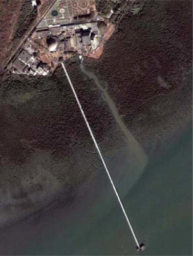
This is an Ikonos image of India's two BARC reactors taken at 10:30 a.m. on February 27, 2000. The dome of Cirusthe 40-megawatt Canadian—supplied heavy-water reactor with which India made the plutonium for its 1974 nuclear test—is clearly visible. To the right of the reactor, in a less distinctive building, is the Indian-built 100-megawatt Dhruva heavy-water reactor. A long, thin structure extending from Cirus into the estuary covers the cooling water intake pipes for both reactors. Just to the right, and parallel to the structure, a short stream carries hot water back into the estuary.
Thermal imagers are inherently of a poorer resolution than visible imagers because the wavelength of the radiation being collected is 20 times longer (about 10 microns). Even with the 120-meter (400 foot) resolution of the thermal imager on Landsat-5, however, the area of hot water in the Chernobyl lake was so large that it could be clearly identified. When all four Chernobyl reactors were operating, they were dumping approximately 8,000 megawatts of heat into the lake.
Ikonos does not carry a thermal imager. Landsat-7, launched in April 1999, has a thermal imager with an improved resolution of 60 meters. India's two plutonium-production reactors at the Bhabha Atomic Research Centre (barc), dump their cooling water into an estuary northeast of Mumbai (Bombay). We therefore acquired a Landsat-7 image of this area taken on April 13, 2000. It shows no sign of a thermal plume. We are not certain whether the reactors were shut down that day, or whether the resolution is too poor to show the small plume we expected to see. Its area would have been about one-fiftieth the size of the hot-water plume produced by the Chernobyl reactors at full power. The image did show thermal plumes associated with the discharges of some large coal-fired power plants nearby.
A striking feature of the Ikonos image of the barc site (opposite page, lower right) is the visible plume of water at the end of the discharge channel. The plume, which is the same color as the water in the discharge channel and lighter than that in the bay, swings to the left along the shore.
We checked the tide at the time the image was taken and the flow should indeed have been in the direction that the plume appears to be carried—out to sea. Thus, it appears from this image that sediment carried by the discharged cooling water made it visible. Since relatively little cooling water would be needed when the reactors are shut down, it might be possible to use this visible indication to determine whether the reactors are operating. The Ikonos satellite can revisit a particular location every two to four days. A government able to afford the cost of a few thousand dollars per image could quickly determine the usefulness of this approach to monitoring reactor operations.
Some man-made objects are so large that their thermal images can be revealing, as in the Landsat-5 thermal image of the U.S. gaseous diffusion plant at Portsmouth, Ohio, shown on the following page.
The roofs of the buildings appear visibly hot in the infrared because their interiors must be maintained at 160 to 180 degrees Fahrenheit in order to keep above-atmospheric-pressure uranium hexafluoride in a gaseous state. When operating at full capacity, the plant consumes 2,260 megawatts of electricity, mostly to operate the compressors that pump the gas through the diffusion barriers. Almost all of this energy is converted into heat.
The gaseous diffusion uranium-enrichment plant at Portsmouth, Ohio, from the air (left) and as seen by the Landsat-5 thermal imager on March 12, 1994. Even though a single Landsat-5 pixel covers an area 400 by 400 square feet, the buildings housing the enrichment equipment cover much larger areas: Building X326 is 2,230 by 552 feet, Building X330 is 2,176 by 640 feet, and Building X333 is 1,456 by 970 feet. (Source: Adam Bernstein, “Monitoring Large Enrichment Plants Using Thermal Imagery from Commercial Satellites: A Case Study,” Sandia National Laboratories report SAND 2000-8671, 2000.)

We acquired a February 3, 1989, Landsat-5 image of China's Lanzhou gaseous diffusion plant. Unlike the Portsmouth plant, it did not show up at thermal wavelengths. Perhaps the plant was not operating, but it is also possible that it was too small for its hot roof to show up at Landsat-5's resolution. Although the plant is 600 meters long, it is only about 60 meters wide—the size of half a pixel in a thermal image from Landsat-5. The result would be less ambiguous with Landsat-7, with its four pixels to each of Landsat-5's one.
A useful technique
Because plutonium production reactors and gaseous diffusion plants require large amounts of energy, images available from the current generation of civilian satellites can show clearly whether or not these plants are operating. Cooling towers put out visible vapor plumes; discharges of hot water and hot roofs are visible in the infrared.
Observations using civilian imaging satellites are less likely to be effective, however, in the case of centrifuge enrichment plants. And countermeasures could mask some of the signatures that are visible today. For example, cooling towers could be operated less efficiently in order to eliminate visible vapor plumes—or the roof of a hot building might be cooled.
However, until on-site verification measures can be agreed on, satellite images may provide the only physical indications available to the outside world that some fissile-material production facilities have been shut down.