
Abstract
The Central Ganga Plain (CGP)—the middle sector of the Indo-Gangetic foreland basin—is a primary area of interest due to its thick and continuous Quaternary alluvial sediments. Its active tectonic setting, with rapid subsidence and structural segmentation, results in a continuous sedimentary record that provides clear evidence of past variability in monsoon and environmental changes. This article presents the reconstruction of the late Quaternary hydroclimatic variability during the last glacial maximum (LGM), post-LGM and the 4.2 ka events using multi-proxy analysis. During post-glacial climatic amelioration, a pronounced paleoenvironmental transition, with a sharp increase in total organic carbon (TOC) (3.97%), TC (6.29%) and C/S ratio (~300) around ~20 ka BP, reflecting enhanced organic productivity and freshwater deposition, is recorded. Mineral magnetism data reveal a significant increase in the concentration-dependent parameters (χlf (105.4 ×10⁻⁸ m3 kg-1); saturation isothermal remanent magnetisation (971 ×10-5 Am2 kg-1), ꭓARM (414 ×10-5 Am2 kg-1)), recording a strong detrital input and monsoon weakening linked to regional aridification. The results align well with contemporaneous lake and fluvial records from the CGP.
INTRODUCTION
The Ganga plain is a densely populated and highly fertile region, and it experiences ~85% of its annual rainfall from the Indian Summer Monsoon (ISM) (Parthasarathy et al., 1987). It is identified as a rapidly subsiding foreland basin with active sedimentation patterns controlled by East-West tectonic lineaments, and the subsidence acts as an asymmetric structure linked to Himalayan tectonics (Singh & Rastogi, 1973; Singh, 1996). The tectonic setting ensures that this inland continental alluvium provides a high-resolution stratigraphic record where fluvial sediments serve as a direct proxy for constraining Quaternary climatic variability. Multiple earlier studies have reported on the past vegetation and climatic conditions, which suggest that the region had experienced large and sudden changes since the last glacial maximum (LGM) (Trivedi et al., 2019). It is also known that at the LGM (~22.2–18.6 ka BP), the area had open vegetation under cool and dry conditions with reduced ISM precipitation (Jha et al., 2024; Trivedi et al., 2012). Between 18.6 and 7.3 ka BP, there was a warm and moderately humid climate, which in turn brought about the growth of open, mixed tropical deciduous forest (Agrawal et al., 2012, 2013). This was followed by a pronounced arid event around 4.2 ka, marked by the weakening of the ISM. Pollen data indicate a change in vegetation from tropical forests to open grasslands, indicating a prolonged dry period (Sengupta et al., 2024). ISM intensity fluctuated, with periods of increased and decreased rainfall (Singh et al., 2005), alternating the vegetation from grassland to more complex forest ecosystems. This study specifically addresses the hydroclimatic shifts during LGM and the 4.2 ka aridification, periods marked by ISM instability by using a set of mineral magnetic and elemental data proxies. We have selectively emphasised the post-LGM transition and the 4.2 ka aridification because these intervals exhibit the most pronounced, proxy-consistent hydroclimatic signals in our dataset, while other periods show comparatively subdued or less coherent variability and are therefore not discussed in detail.
Paleoclimatic reconstructions from the Central Ganga Plain (CGP) have been extensively documented using a multi-proxy approach that includes pollen, phytoliths, isotopes and geochemistry from various lacustrine deposits. Key study sites include Misa Tal, Sanai Tal, Chaudhury Ka Taal, Kikar Tal, Baraila Tal and Nikhari Tal (Misra et al., 2020; Saxena et al., 2011, 2015; Saxena & Singh, 2017; Saxena & Trivedi, 2017; Sharma et al., 2004), as well as Lahuradewa Lake (Saxena et al., 2013), Jalesar Lake, Lashoda Tal (Trivedi et al., 2013, 2019) and Kareela Jheel (Chauhan et al., 2015; Tripathi et al., 2017). The objective of this study is to enhance the existing paleoclimatic record of the CGP by combining mineral magnetic analyses and elemental (CHNS) geochemistry within a well-constrained AMS radiocarbon chronological framework.
GEOLOGICAL SETTINGS
The study site is located in Lucknow, the state capital of Uttar Pradesh, situated along the Gomti River, and the entire region comes within the Ganga Plain. This plain is a flat and fertile alluvial plain underlain by Quaternary sediments consisting of sand, silt and clay with calcareous nodules (Prasanna et al., 2025; Singh et al., 1999, 2013). It is one of the largest alluvial tracts in the world, which offers excellent potential for reconstructing past monsoon variability due to its extensive network of lakes, floodplains and abandoned channels that preserve continuous sedimentary records (Singh, 1996; Srivastava et al., 2003). The entire area is broadly characterised by older alluvium, dating to the middle to late Pleistocene, which consists of grey to brown silt, clay and sand with occasional Kankar. Overlying this unit is the newer Alluvium of Holocene age, which is further subdivided into terrace and channel alluvium. This younger sediment occupies the river courses, forming the present and former floodplains (Sarangi et al., 2021; Singh et al., 1999; Venu et al., 2022).
METHODOLOGY
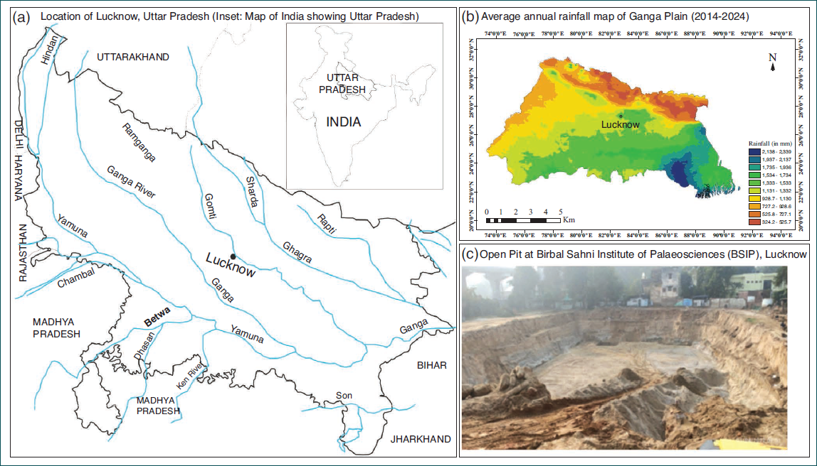
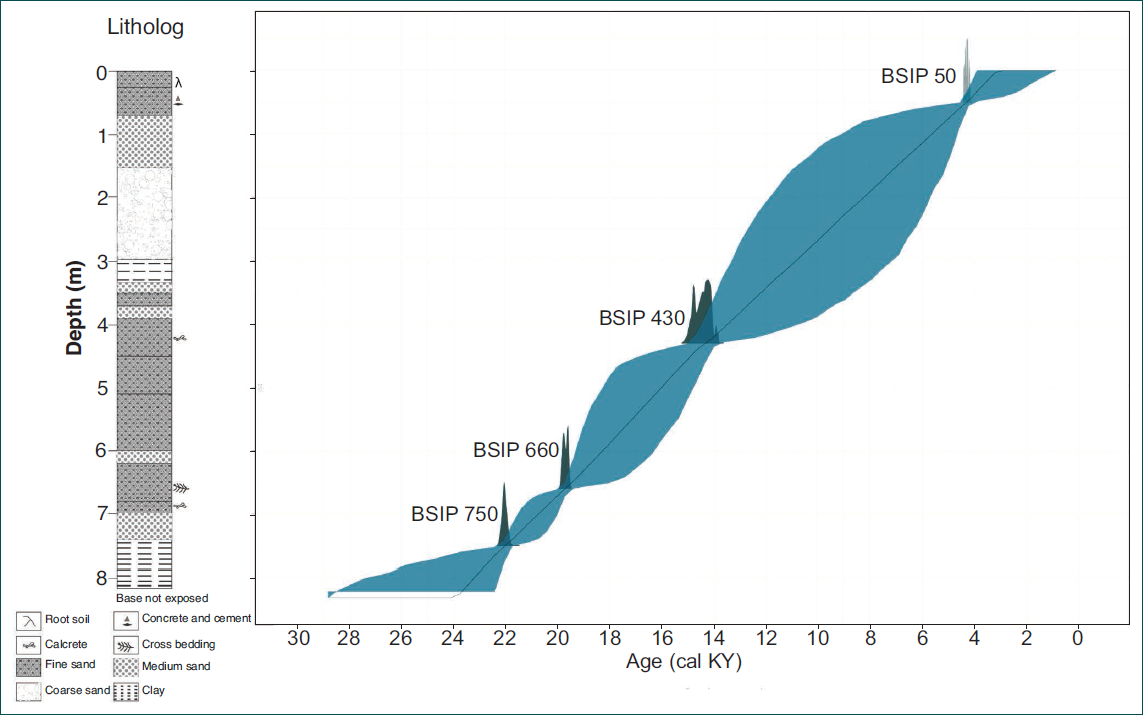
Samples were collected from an 8 m sediment trench within the premises of the Birbal Sahni Institute of Palaeosciences, Lucknow, Uttar Pradesh, India (26°52′00.9″N, 80°56′21.5″E) (Figure 1). From the 8 m trench on the natural floodplain, 400 samples were collected for the analysis (chronology, environmental magnetism and elemental analysis). The samples were placed at equal intervals with continuous sampling. The litholog was prepared, and layers of sand, silty sand and silt were seen (Figure 2).
(a) Map Showing the Locations of Lucknow Sample Collections. (b) Average Rainfall Map of Ganga Plain (2014–2024). (c) Photograph of the Sampling site at Birbal Sahni Institute of Palaeosciences, Lucknow.
Litholog and the Age-depth Model Based on Bayesian Modelling of 14C Dates from the Trench Section of BSIP in Lucknow.
Accelerator Mass Spectrometry Chronology
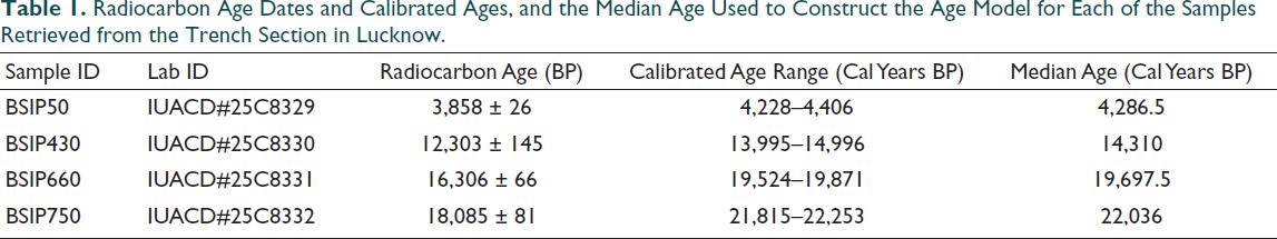
Radiocarbon dates were obtained from the accelerator mass spectrometry (AMS) radiocarbon dating of four samples (50, 430, 660 and 750 cm from the top of the section, Table 1), at the Inter-University Accelerator Centre (IUAC), New Delhi, India (Kumar et al., 2022). The samples (~5 mg) were pretreated with a standard Acid-Base-Acid (ABA) method to remove inorganic carbonates. Following pretreatment, the purified material was converted into graphite targets using an automated graphitisation system (AGE). Once graphitised, the radiocarbon content was measured using a 500 kV Pelletron accelerator-based mass spectrometer, with primary and secondary standards and process blanks included for quality control and normalisation (Sharma et al., 2019). The measured results for all the samples are normalised to the standard sample OX II. AMS δ13C values are used for the isotopic fractionation correction. The background value during the measurement was (0.400 ± 0.0141) pMC (percentage modern carbon), and that corresponds to a 14C/12C ratio (4.3614 ± 0.1530) × 10−15. Data quality is monitored with a secondary standard (IAEA-C7). During measurement, its consensus value (pMC = 49.53 ± 0.12) matched its experimental result (pMC = 49.75 ± 0.22) within the error. The age-depth model and radiocarbon calibration were performed in R software using the Bayesian radiocarbon chronology package ‘Bchron’ (Haslett & Parnell, 2008; McKay et al., 2021; Parnell, 2016; R Core Team, 2016; Reimer et al., 2020) and with the ‘IntCal20’ calibration curve (McKay et al., 2021; Reimer et al., 2020).
Radiocarbon Age Dates and Calibrated Ages, and the Median Age Used to Construct the Age Model for Each of the Samples Retrieved from the Trench Section in Lucknow.
Mineral Magnetism
A total of 410 bulk sediment samples were collected to conduct environmental magnetic analyses. Mineral magnetic characterisation followed established protocols by Walden (1999). The measurements encompassed magnetic susceptibility (χ), frequency-dependent susceptibility (χfd%), anhysteretic remanent magnetisation susceptibility (χARM) and saturation isothermal remanent magnetisation (SIRM). Before measurements, samples were air dried and crushed with an agate mortar and pestle, and packed in pre-weighted, non-magnetic 10 cc cylindrical plastic bottles. Magnetic susceptibility (χ) was determined at both low (976 Hz; χlf) and high (15,616 Hz; χhf) frequencies using MFK2-FA Multifunction Kappabridge (AGICO, Czech Republic). Anhysteretic Remanent Magnetisation (ARM) was induced with an ASC Scientific D-2000AF demagnetiser (with an ARM attachment) in a steady DC bias field of 0.05 mT superimposed on a decaying alternating field (a.f.) peaked at 100 mT at a decay rate of 0.001 mT per cycle. The mass-specific ARM was then normalised by this DC bias field (0.05 mT = 39.79 A/m) to calculate the ARM susceptibility (χARM) (Liu et al., 2012; Walden et al., 1999). Isothermal remanent magnetisation (IRM) was induced in selected samples by increasing field strengths (20, 100, 200, 300, 500, 800 and 1,000 mT) and backfield demagnetisation up to 300 mT using an ASC Scientific IM-10–30 impulse magnetiser. Remanence was measured with an AGICO JR-6 spinner magnetometer. The IRM at the maximum field of 1,000 mT was defined as the SIRM. The S-ratio (|IRM-300 mT|/SIRM) was used to evaluate the relative contributions of low-coercivity ferrimagnetic minerals (e.g., magnetite) versus high-coercivity antiferromagnetic minerals (e.g., hematite, goethite) (Evans & Heller, 2003; Thompson & Oldfield, 1986).
CHNS Elemental Analysis
The analyses of carbon, sulphur and Total Organic Carbon (TOC) (expressed in wt%) were determined using an Elementar™ Vario MACRO Cube (CHNS-O) analyser. Elemental analysis (for TC, S, H and N) was measured at 10 cm intervals (n = 84), while TOC% was measured at 50 cm intervals (n = 25). For analysis, approximately 200–250 mg of each sample was precisely weighed on a microbalance (±0.0001 mg sensitivity, Sartorius Quintix) and encapsulated in 6 × 12 mm tin boats. The prepared sample boats were loaded into the EA autosampler and analysed. During the process, samples were combusted at 1,150°C in an oxygen-rich environment within the combustion column and the resulting combustion gases (CO2, H2O and SO2) were transferred to the reduction column operating at 850°C (Salani et al., 2021). The percentages of C, H and TOC were then sequentially measured by a thermal conductivity detector (TCD), and S will be measured using an infrared detector (IR), with helium serving as the carrier gas. Analytical reproducibility was monitored using sulfanilamide standards, which yielded standard deviations of ±1% for carbon, ±0.4% for nitrogen, ±0.2% for sulphur and ±0.1% for hydrogen.
RESULTS
Chronological Framework, Lithology and Age-depth Model
The chronological framework, lithological characteristics of the BSIP sediment profile (8 m) and age-depth model are presented in Figure 2 (Table 1). The 14C AMS chronology record covers ~24–3 ka BP.
Lithology
The study location lies within the Ganga Basin, characterised by a flat alluvial terrain composed of varying grades of sand, silt and clay, including Quaternary-age kankar deposits (Singh et al., 1999). The lithological profile (Figure 2) comprises an approximately 8 m thick stratigraphic succession dominated by sandy deposits with subordinate clay horizons and pedogenic features. The lowermost exposed unit (6.8–7.3 m) consists of loosely compacted sand containing abundant calcrete nodules, suggesting pedogenic carbonate formation under subaerial exposure conditions. The base of this unit is not exposed in the studied section. This unit is overlain by medium sand between 6.0 and 6.8 m, displaying distinct cross-bedding structures indicative of tractional current deposition under relatively higher-energy fluvial conditions (Singh et al., 1999). Above this interval, the succession from 3.3 to 6.0 m depth is dominated by fine sand with occasional calcrete nodules, reflecting periodic pedogenic carbonate development within a predominantly sandy depositional setting. A thin clay horizon (~0.3 m thick) occurs between 3.0 and 3.3 m, representing a distinct fine-grained interval likely associated with a relatively low-energy depositional phase. Overlying this clay layer is approximately 1.0 m of coarse sand (2.0–3.0 m) characterised by poorly sorted, granular texture, suggesting deposition under comparatively higher-energy conditions. This is followed upward by ~1.5 m of medium sand (0.5–2.0 m) forming the upper sandy sequence. The uppermost ~0.5 m of the profile comprises root-bearing soil, representing the modern pedogenic horizon, which is locally overlain by a thin anthropogenic layer of concrete and cement.
Overall, the stratigraphic succession is characterised by stacked sandy units with intermittent clay intercalations and pedogenic calcrete formation, reflecting episodic fluctuations in depositional energy and phases of subaerial exposure within the alluvial environment of the Ganga Plains. Sediment accumulation rates, calculated from the relationship between depth and radiocarbon age, range from 0.032 to 0.071 cm yr-1, indicating variable depositional dynamics through time.
Mineral Magnetism
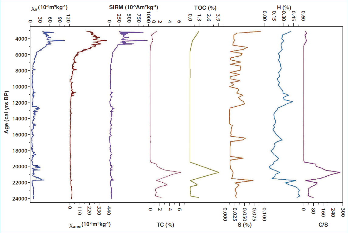
The mineral magnetic analysis was done in the Palaeomagnetism laboratory of BSIP. The results of the environmental magnetism concentration parameters (χlf, χARM and SIRM) of the BSIP sediment profile exhibit marked temporal variability since ~24 ka BP. Low-field magnetic susceptibility (χlf) is a concentration-dependent parameter and quantifies the aggregate magnetic susceptibilities of various magnetic minerals, including ferrimagnets (e.g., magnetite), canted antiferromagnets (e.g., haematite), paramagnets (e.g., pyrite and biotite) and diamagnets (e.g., water and organic matter) (Thompson & Oldfield, 1986; Walden et al., 1999). Ferrimagnetic minerals exhibit strong magnetism, while para- and diamagnetic minerals have a weak one (Thompson & Oldfield, 1986). The BSIP section displays considerable variability in χlf, ranging from 3.5 to 105.2 × 10⁻⁸ m3 kg–1 with an average of 14.7 × 10⁻⁸ m3 kg–1. The susceptibility of χARM, which preferentially reflects stable single-domain (SSD) grains (Maher, 1988), varies from 1.63 to 414.36 × 10⁻⁸ m3 kg–1, with an average of 47.1 × 10⁻⁸ m3 kg–1. The SIRM, reflecting the total concentration of remanence-carrying minerals, varies from 6.15 to 971.6 × 10⁻⁵ Am² kg–1, with an average of 74.5 × 10⁻⁵ Am² kg–1.
The variations in environmental magnetic parameters throughout the BSIP sediment profile are illustrated in Figure 3. All parameters exhibit significant variation over the past approximately 24 ka BP. The concentration-dependent parameters χlf, χARM and SIRM display somewhat similar trends.
Magnetic Textural Data, Total Organic Carbon (TOC), Total Carbon (TC), Sulphur (%), Hydrogen (%) and C/S Ratio of the Trench Section of BSIP in Lucknow.
CHNS Elemental Analysis
Elemental geochemical analysis (C, H, N, S) of the BSIP trench profile indicates a significant shift in the depositional conditions. The profile records a sudden, sharp transition from sediments with high TC%, TOC% and C/S ratio and low S%, as shown in Figure 3. The trench profiles of the elemental percentages, namely the TOC%, total sulphur (S%) and the carbon-to-sulphur (C/S) ratio, reveal a distinct geochemical shift centred between ~630 and 750 cm from corresponding to ~19–22 ka BP. After 630 cm, TOC and sulphur contents remain relatively low and stable up to 50 cm, corresponding to 4.2 ka. On the basis of the plots of the studied proxies, we can see three broad zones with two main episodes of climate-influenced vegetation change recorded: the LGM, post-LGM climate and the 4.2 ka aridification event, both of which are discussed in detail below. The hydrogen content (H%) shown in Figure 3 reflects variations in the hydrogen-bearing organic fractions and moisture-related components within the sediment profile, thereby serving as a supplementary indicator of organic matter preservation and depositional conditions. It is also one of the primary elements plant use in the largest amounts. The amount of hydrogen in the soil affects the pH value, too. Its co-variation with TOC% suggests that intervals of elevated H% correspond to enhanced organic input and relatively wetter depositional environments.
DISCUSSION
Climate Variability During Last Glacial Maximum
The CGP experienced significant paleoclimatic changes during the LGM and subsequent periods. The LGM (~25–18 ka BP) represented the weakest monsoon phase with arid conditions, as evidenced by isotopic records and pollen data (Agarwal et al., 2013; Jha et al., 2024). Our data strongly indicate cold and arid conditions during the LGM, consistent with regional records. The low values of magnetic susceptibility (χlf), SIRM and ARM suggest a minimal influx of detrital magnetic minerals and suppressed pedogenic formation of fine-grained magnetite (Maher, 1988). The low S-ratio (~0.68) points to a relative enrichment of high-coercivity minerals (hematite and goethite), which are characteristic of poorly weathered sediments in arid, oxidising environments (Thompson & Oldfield, 1986). A multiproxy record from the Lashoda Tal, located 55 km southwest of Lucknow, suggested a cool, dry climate with a Savannah type of vegetation and a seasonal lake with incipient drainage and low energy during the LGM (~25,500–22,200 years BP) (Trivedi et al., 2019).
Following LGM, the transition period is marked in our records by a sharp increase in TOC%, TC% and exceptionally high C/S ratios around ~20,700 years ago, indicating a period of enhanced organic matter preservation and productivity. This interpretation is consistent with established paleoclimatic reconstructions for the region. Specifically, our data strongly align with a study by Trivedi et al. (2019) from Lashoda Tal. Their findings demonstrate that between approximately 22.2 and 14.3 ka BP, the region experienced significantly wetter conditions under a strengthened winter monsoon. This is evidenced by fine-grained sediments and a notable expansion of trees and shrubs, including moisture-loving taxa such as Madhuca indica, Acacia nilotica and Syzygium cumini, alongside the emergence of shrubby thickets. The strong correlation between the proxy records from Lashoda Tal and the findings from this study confirms that the Lucknow region also experienced similar environmental shifts, transitioning from LGM aridity to post-LGM climatic amelioration.
Climate Variability During Last Glacial Maximum
During 20–18 ka BP, the concentration-dependent magnetic parameters χlf and χARM exhibited elevated values. This enrichment is most plausibly attributed to a stronger detrital influx under intensified ISM. During Heinrich Stadial 1 (H1; ~18–14.5 ka BP), concentration-dependent magnetic parameters (χlf and χARM) show relatively low values, suggesting a decline in the overall concentration of magnetic minerals and reduced detrital influx. During the Bølling–Allerød (BA; 14.5–13 ka BP), the concentration-dependent magnetic parameters χlf and χARM exhibited elevated values. This enrichment is most plausibly attributed to stronger detrital influx under intensified ISM during the BA period (Bond et al., 1997; Kathayat et al., 2017; Overpeck et al., 1996; Phartiyal et al., 2024).
The Younger Dryas marks a period of rapid climatic deterioration, widely recognised as a cool and dry interval (Alley, 2000; Rasmussen et al., 2006; Wang et al., 2001). The concentration-dependent magnetic parameter χlf during this period shows a declining trend, indicating a decreasing concentration of magnetic minerals, suggesting a decline in detrital influx and weakening of ISM. The mineralogical parameter S-ratio shows a decreasing trend, which demonstrates that increasing the high coercivity minerals (hematite and goethite) suggests a declining precipitation during this period.
The BSIP sediment profile reveals a constraint rise in the concentration-dependent parameters (χlf and χARM) and mineralogical indicators such as the S-ratio during the intervals 6–3 ka BP.
The post-LGM paleoclimate record from the BSIP sediment profile extends our understanding of late Quaternary hydroclimatic variability. These findings, compared with existing paleoclimatic records from the CGP, refine our understanding of the spatial and temporal patterns of monsoon-driven environmental change across the region. These findings from the sediment profile indicate periodic increases in organic productivity and freshwater conditions during the post-glacial period (~20,000 years BP). TC reaches 6.29% and the C/S ratio attains values of ~300, marking the maximum concentration of organic matter recorded in the sediment profile, especially around ~20.7 ka BP. Persistently low sulphur levels point particularly to organic matter accumulation under freshwater conditions. The measured organic carbon fraction (Corg = 3.97%) confirms that this enrichment is due to organic input rather than carbonates. Taken together, these observations suggest a sudden and isolated pulse of organic matter accumulation in a freshwater depositional environment. These results are consistent with pollen records from adjacent lake deposits, where vegetational expansion (arboreal assemblages) and wider lake development are recorded around the post-glacial period (Jha et al., 2024; Trivedi et al., 2012, 2019).
The 4.2 ka Aridification Event
The second climatic episode recorded from this section was a regional climatic transition to drier conditions in the late Holocene, commencing around ~4–3.5 ka BP. This episode is also reflected in evidence from lake desiccation in Karela Jheel (Tiwari et al., 2026; Tripathi et al., 2017), a semi-closed fluvial ecosystem; intermittent water conditions around 4.2 ka at the Ganga-Sai River interfluve (Farooqui et al., 2023); and a regional decline in arboreal pollen, marked by the incursion of warm and humid loving tree taxa (Moringa and Bombax ceiba) between 4.2 and 1.8 ka BP (Saxena & Trivedi, 2017). This collective archive has been important in reconstructing paleovegetation and hydroclimate variability, establishing a coherent framework of monsoon-driven environmental change in the region. The signals of these major paleoclimatic shifts during both the LGM and the 4.2 ka event are also observed in the CGP, emphasising the region’s sensitivity to global climate drivers.
A particularly significant peak concentration occurs around ~4.2 ka, where the magnetic proxies (χlf = 105.2 ×10⁻⁸ m3 kg–1; SIRM = 971 × 10–5 Am² kg–1; ꭓARM = 414 × 10–5 Am² kg–1) spike sharply, representing a massive influx of magnetic minerals. Concurrently, the abrupt decline in pedogenic indicator (ꭓfd%) and an increase in detrital magnetic concentrations (ꭓlf, SIRM), pointing to increased erosion under a weak ISM. The co-occurrence of elevated χlf and SIRM with depressed χfd% and χARM/SIRM ratios provides a diagnostic mineral magnetic signature for an increased influx of coarse-grained, detrital magnetite. So, it is interpreted as not a signal of enhanced soil development, but as an erosional event. This event is widely documented across South Asia as a major phase of aridity and monsoon weakening that impacted ancient civilisations (Dixit et al., 2014; Staubwasser et al., 2003). The 4.2 ka interval is clearly registered in multiple lake records from the CGP as a pronounced aridification event. This event is further exemplified by the completion of lake formation at Chandrika Devi Lake around 4.1 ka BP, coinciding with the weakening of the ISM and the beginning of human agricultural activities (Sengupta et al., 2024). Similarly, from the Ganga-Sai River interfluve, Farooqui et al. (2023) identified calcrete layers signifying high aridity between ~5 and 4.6 ka BP, culminating in a peak cold-dry event at ~4.2 ka. Phytolith data from Lahuradewa lake indicate that the 5.3–4.1 ka BP dry phase was the most severe in the last 10,600 years (Saxena et al., 2013). Consistent with this, Kikar Tal recorded reduced monsoon conditions from 4.2 to 1.8 ka BP (Saxena & Trivedi, 2017). The multiproxy record from Lonar Lake, central India, has also documented dry climatic conditions around 4.3–4.2 ka BP. The event represents an approximately 300-year period of major climate change, characterised predominantly by dry conditions from the Eastern Mediterranean to India, driven by the southward migration of the Intertropical Convergence Zone (ITCZ) (Helama, 2024). High-resolution speleothem records from Northeast India reveal that monsoon intensity abruptly decreased around 4.0 ka BP, initiating a multi-centennial period of reduced precipitation punctuated by multi-decadal droughts (Kathayat et al., 2017). The CHNS-derived geochemical proxies from the BSIP trench provide insight into the ~4.2 ka aridification event.
In contrast to the pronounced organic enrichment observed during the post-LGM phase, the interval corresponding to ~4.2 k yr BP is characterised by persistently low and relatively stable TOC and TC values, alongside subdued sulphur concentrations, indicating a marked decline in organic matter accumulation and overall bioproductivity. The absence of elevated TOC (previously reaching up to ~3.97%) and the lack of high C/S ratios (which peaked at ~300 during wetter phases) suggest a transition to oxidising, low-moisture depositional conditions with reduced preservation of organic carbon. Such geochemical signatures are consistent with diminished vegetation cover and enhanced sediment oxidation under a weakened ISM. The stabilisation of low sulphur further supports limited waterlogging and reduced anoxic conditions, implying a shift away from sustained freshwater depositional environments.
CONCLUSION
In this study, a sediment profile from a trench section in Lucknow (CGP) is examined through integrated magnetic and elemental (CHNS) analyses, constrained by a robust AMS 14C chronology spanning ~24 to ~3 ka BP to decipher late Quaternary climate variability. Our record captures the well-known LGM period and the 4.2 ka dry event and is supported by other studies from the Ganga plains. The Lucknow region, which is in CGP, has experienced a cold and dry climate, which supported a landscape dominated by open grasslands under a weakened monsoon during 24–20 ka BP (LGM). The high sulphur peak during the LGM likely reflects enhanced sulphur preservation under relatively reducing, low-energy depositional conditions, possibly linked to localised water stagnation or sulphide formation. The post-LGM period in this region was marked by a trend of climatic conditions around 20.7 ka BP, characterised by the strengthening of the monsoon that led to high organic productivity and the initial expansion of tree taxa into the prevailing grassland. Magnetic parameters exhibit a distinct shift around 4.2 ka, indicating a reduction in pedogenic intensity and reflecting a phase of monsoon weakening and aridification, correlating well with the globally recognised 4.2 ka climatic event. The same interval is also marked by strong aridity and oxidising conditions, which inhibit sulphur preservation and promote its loss. Additionally, increased detrital influx and erosion during 4.2 ka diluted sulphur concentrations despite climatic stress. The post-LGM phase reflects a strengthened winter monsoon, as indicated by enhanced organic productivity and freshwater conditions, suggesting increased seasonal moisture availability. This winter monsoon intensification likely played a complementary role alongside ISM variability in shaping the hydroclimatic regime of the CGP. The correspondence between these proxies and previously reported regional records confirms that the Lucknow soils also preserve signatures of major Quaternary climatic perturbations that affected the broader Indo-Gangetic Plain.
Footnotes
Acknowledgements
The authors are grateful to the Director, Birbal Sahni Institute of Palaeosciences (BSIP), Lucknow, India, for the necessary facilities for carrying out this research work (BSIP/RDCC/121/25-26). The authors are also thankful to the entire team of QLDP and the technical staff for their assistance in sampling. The present manuscript is the outcome of the BSIP in-house Project (Thrust Area 8, QLDP-Phase 2).
Declaration of Conflicting Interests
The authors declared the following potential conflicts of interest with respect to the research, authorship, and/or publication of this article: Authors Binita Phartiyal and Prasanna K. are the Editor and Associate Editor respectively of the Journal of Palaeosciences. The authors did not take part in the peer review or decision-making process for this submission and have no further conflicts to declare.
Funding
The authors disclosed receipt of the following financial support for the research, authorship and/or publication of this article: The authors are thankful to IUAC for extending the AMS facility for 14C funded by the Ministry of Earth Science (MoES), Government of India, with reference numbers MoES/16/07/11(i)-RDEAS and MoES/P.O.(Seismic)8(09)-Geochron/2012.