
Abstract
Clarifying how to systematically manage ecosystem services is crucial for addressing urban-rural conflicts and promoting urban-rural sustainable development, while ecosystem service optimization offers an effective approach. The optimization of ecosystem services encompasses not only the traditional supply and demand but also the entire process, including supply, flow, and demand, especially for the complex urban-rural socio-ecological systems. The metacoupling framework can offer a feasible theoretical approach for advancing the spatial optimization of ecosystem service supply-flow-demand and adaptively explain the interaction relationships between urban and rural regions. This study first explored urban-rural patterns and the complex characteristics of socio-ecological systems to understand the metacoupling mechanisms, including intracoupling, pericoupling, and telecoupling, between urban areas, urban-rural fringes, and rural areas. Furthermore, by integrating the spatial relationships of ecosystem services supply-flow-demand with the entire process assessment approaches, we interpreted varied urban-rural metacoupling interactions of ecosystem services nexus. Finally, a metacoupling-based ecosystem services supply-flow-demand optimization framework was developed, which considers reducing supply-demand trade-offs, balancing supply-demand deficits, and improving flow efficiency. The metacoupling framework for urban-rural ecosystem services optimization constructed in this study provides a new research perspective and adaptive theoretical approach for the comprehensive and sustainable management of urban, urban-rural fringe, rural ecosystem services.
Introduction
Ecosystem services are the foundation for human survival and development. The supply, demand, and flow of ecosystem services are three basic elements for understanding how ecosystem services link natural ecosystems with human social systems (Bagstad et al., 2014). In recent years, with rapid socio-economic development, there have been significant changes in landscape patterns and ecological processes, which have severely impacted the spatial patterns and relational mechanisms of the supply, demand, and flow of ecosystem services (Costanza et al., 2017). Urban expansion has caused severe degradation of ecosystem service supply. The urbanization process, along with the decline of ecosystem services and the increasing demands of people, can lead to an exacerbation of the imbalance between the supply and demand of ecosystem services (Burkhard et al., 2012). In addition to the imbalance in supply and demand within the same spatial area, there is often also a spatial mismatch between the supply of ecosystem services in a region and the demands of human society (Shen and Wang, 2021). This mismatch needs to be addressed by linking supply and demand through ecosystem service flow. To clarify the interactions and flow relationships between natural ecosystems and human social systems, it is necessary to consider not only the supply and demand of ecosystem services but also the flow process (Wang et al., 2022a). Thus, the integrated management of the entire process of ecosystem service supply, flow, and demand would help promote the sustainable development of landscapes and regions.
Many countries in the world are facing issues of social, economic, and environmental disparities between urban and rural areas, particularly in developing countries. Due to limited access to basic infrastructure services in small towns and rural areas, such as electricity and transportation, economic development in these regions often falls behind that of urban areas. Meanwhile, urban areas, due to the high density of human activities, often experience severe environmental degradation (Ferré et al., 2012). A strict division of conventional rural-urban binary is generally not adequate to make different populations aware and act upon the education levels, economic gaps and environmental management. A position along the urban-rural transitional landscape and within the hierarchical settlement system would offer us a more nuanced perspective for understanding the spatial relationships between humans and nature (Liu et al., 2024). Many resources, like food, water, raw materials, etc., consumed in urban areas are often heavily reliant on the surrounding suburbs and rural areas (Gebre and Gebremedhin, 2019). For example, the supply and demand of food between urban and rural areas are closely interconnected. Rural areas provide food to urban areas to improve livelihoods, while cities rely on the surrounding suburbs and rural areas for resources and ecosystem services. A detailed analysis of the food system within the urban-rural continuum is more conducive to accurately capturing the spatial information and formation mechanisms of food insecurity. The issue of food security needs to be addressed at a macro scale, encompassing the urban-rural fringe in which food systems operate. Many developing countries around the world, such as China, India, Brazil, and Indonesia, as well as developed countries in Europe like the Netherlands and Germany, are focusing on strengthening the connections of ecosystem services between urban and rural areas (Tefft et al., 2017). Therefore, advancing the integration of ecosystem services for urban and rural areas is of great practical significance for coordinating ecological environments and ensuring sustainable development (Allawi and Al-Jazaeri, 2023; Fang et al., 2024b).
As the rapid increase in urban population and built-up land may lead to severe ecosystem service supply-demand deficits and blockages in service flow (Xu et al., 2021), it is urgent to clarify the supply-demand relationship and flow mechanisms of ecosystem services across urban-rural continuum. Usually, urban-rural ecosystem services' spatial flow between human urban-rural systems and natural coupled systems is based on a metacoupling process (Liu et al., 2016). The metacoupling framework enables research on the connections between different locations, multiple coupled systems, and various scales (Liu, 2023). It has been applied in global food trade, long-distance water transfer, tourism, species migration, and other fields (Sun et al., 2018). The flow of ecosystem services is the result of the exchange of materials, energy, and information between the supply area of ecosystem service, such as natural habitats or rural areas with high natural quality, and the beneficiary area of ecosystem service, urban centers or some densely populated suburbs (Kleemann et al., 2020). Thus, a metacoupling framework is a feasibility framework that can be used to explain the entire-process mechanism and management of ecosystem services supply-flow-demand of urban-rural regions.
To achieve effective governance and manage the urban-rural ecosystem services, spatial optimization provides a means and tool worth advocating (Guerry et al., 2015). There are usually several bases for optimization: based solely on ecosystem service supply (Zhang et al., 2023b); based on the relationship between ecosystem service supply and demand (Li et al., 2023a); based on the trade-off between ecosystem service supply and demand (Feng et al., 2021); and based on the integration of ecosystem service supply, demand, and flow (Fang et al., 2024a). The optimization of ecosystem service flow helps promote coordinated development between regions, especially between urban and rural areas. Additionally, optimizing the entire process of supply-flow-demand can alleviate spatial inequalities in ecosystem services and reduce the resource consumption associated with the flow process (Zhai et al., 2021). Specifically, optimizing the direction, volume, and efficiency of the flow can enhance the utilization efficiency of ecosystem services, thus alleviating supply-demand imbalances. Improving the efficiency of ecosystem service flow also facilitates reducing the economic costs of the flow process, promoting the improvement of both ecological and socio-economic systems (Fang et al., 2024a). Optimization based on the entire process of ecosystem service supply-flow-demand is a promising development direction, and it also aligns well with the metacoupling framework. This typically requires considering both the optimization of pericoupling ecosystem services within the regional ecosystem and the telecoupling optimization between internal and external regions. By combining multi-objective analysis, and scenario simulation (Luan et al., 2024; Naidoo et al., 2008; Tang et al., 2024), urban-rural metacoupling-based ecosystem services optimization should not only optimize the traditional ecosystem services supply and demand but also can combine the flow paths and modes.
For urban and rural areas, during the process of implementing ecosystem service supply-flow-demand metacoupling assessment and optimization, it is possible to quantitatively assess and analyze the coupling mechanisms of ecosystem service supply, flow, and demand based on understanding of the urban-rural socio-ecological complex system. In many countries around the world that face urban-rural contradictions, the optimization and regulation strategies proposed by extension research are conducive to promoting the integration of urban and rural areas as well as landscape sustainability (Figure 1). The process needs to address the following two key issues: (1) How to understand the urban-rural ecosystem services “supply-flow-demand” relationships and related metacoupling mechanisms? (2) How to carry out the entire process optimization based on ecosystem service “supply-flow-demand” nexus framework to promote urban-rural socio-ecological sustainability?
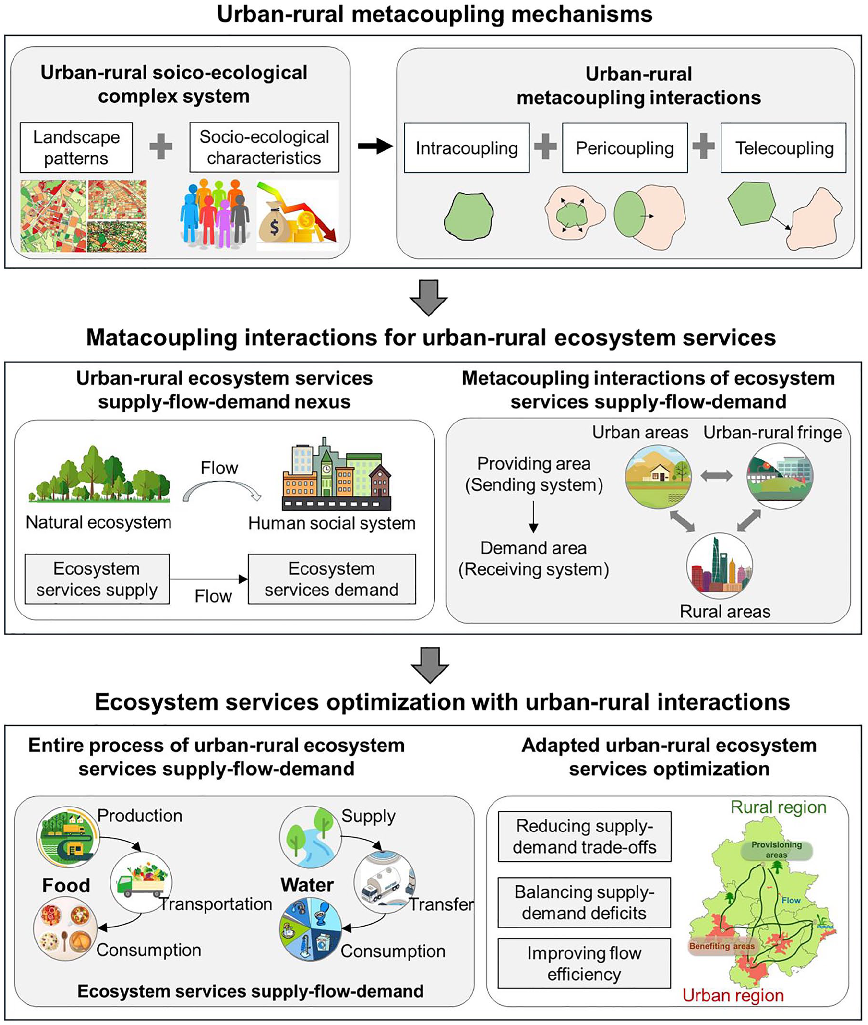
The framework for the metacoupling mechanisms of urban-rural ecosystem service supply-flow-demand interactions and optimization.
Urban-rural metacoupling mechanisms
Urban-rural patterns and socio-ecological characteristics
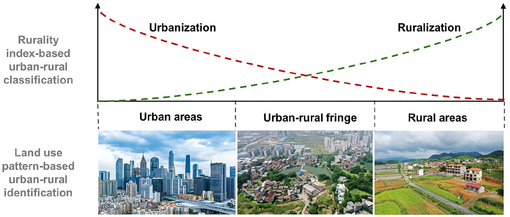
Since the concept of urban and rural areas emerged, the exact boundary between them has been a subject of controversy (Woods and Heley, 2017). For a long time, the division between urban and rural areas has predominantly been binary, but this approach usually overlooks the interactions and connections between the two and fails to reflect the ecosystem service capacity provided by regions of different scales. In the early 21st century, the concept of a continuous continuum from rural to urban areas began to take shape to address the limitations of the binary approach (Cattaneo et al., 2021). Unlike the urban-rural dichotomy, the urban-rural continuum does not distinguish between urban and rural areas from a simple binary perspective. According to the degree of urbanization or ruralization of a region, there exists a transitional zone between urban and rural areas, commonly referred to as the urban-rural fringe or suburban region (Simon, 2008) (Figure 2). Due to its location between urbanized areas and rural regions, this special zone often incorporates both urban and rural characteristics, resulting in complexity and heterogeneity across multiple dimensions such as ecological environment, social structure, and economic activities (Gonçalves et al., 2017; Vizzari and Sigura, 2015). The urban-rural fringe is often characterized by a complex population structure, high population mobility, diverse economic activities, intense land-use conflicts, uneven development of infrastructure and public services, and various social conflicts (Kontgis et al., 2014). It is a transitional area where urban and rural landscapes are intermingled and urban and rural functions overlap, making it a key area for achieving urban-rural integration and sustainable development (Wang et al., 2023b).
Urbanization characteristics and classification for an urban-fringe-rural area.
When analyzing urban and rural ecosystem service issues, it is essential to understand the spatial patterns of urban-rural areas. Typically, there are several common approaches to studying the urban-rural gradient. Firstly, linear transects (unidirectional) are established along the urban-rural gradient, where sampling points are arranged according to the pattern of the gradient. This type of urban-rural gradient research is mainly suitable for simulating the distribution or diversity of natural vegetation (Vakhlamova et al., 2014) and obtaining on-site water quality parameters (Kunz et al., 2023), etc. Another approach involves representing the urbanization gradient by expanding outward from the city center along a concentric circle buffer or concentric ring-shaped expansion (omnidirectional). This type of urbanization gradient research is primarily used to explore the patterns of urban land expansion (Wang et al., 2022b) and the spatial scaling laws of ecological and environmental indicators (Sun et al., 2023). The third approach involves the division of urban and rural areas or the identification of urban and rural landscapes. This method is often utilized to identify and contrast the differences in indicators, such as vegetation phenology (Ji et al., 2023), ecosystem services (Fang et al., 2024a) across various urban and rural zones, to explore the patterns of urban-rural spatial heterogeneity, and most importantly, to underpin the sustainable planning and management of urban and rural regions. Such urban-rural identification and classification can also provide a zonal foundation for the quantitative assessment and spatial optimization of the supply, demand, and flow of urban and rural ecosystem services.
Due to the complex characteristics of urban-rural transitional patterns, delineating their spatial extent is often relatively difficult (Xu et al., 2020). Currently, the main identification methods can be divided into two types (Figure 2): (1) Rurality index-based method: this method calculates a rurality index based on a set of physical or socio-economic indicators, typically at the administrative unit scale. Clustering analysis is then used to classify areas based on the index values, and a threshold is set for urban-rural classification (Dická et al., 2019; Gonçalves et al., 2017); (2) Land use pattern-based method: this method detects inflection points or critical values based on land use patterns, primarily at the grid unit scale. Techniques such as wavelet transform and clustering analysis are often used to delineate urban-rural boundaries (Feng et al., 2020; Peng et al., 2020). In addition, using full-resolution network models for urban-rural classification is also a promising approach. This model, based on convolutional neural networks, utilize convolutional kernels to consider the relationships between neighboring pixels. It is capable of integrating multi-resolution data while maintaining high-resolution features (Wang et al., 2024).
Urban-rural metacoupling interactions
The urban areas, urban-rural fringe zones, and rural areas are all complex social-ecological systems. The interactions of social and ecological activities, both within these urban-rural areas and across regional boundaries, often exist between human social systems and natural ecosystems. While metacoupling theory and framework reflects the interactions and feedback mechanisms between human social and natural coupled systems at multiple scales, both nearby and distant (Liu, 2017; Tromboni et al., 2021). The concept of metacoupling extends from “telecoupling” and includes intracoupling, pericoupling, and telecoupling. Among them, “telecoupling” is the most commonly mentioned concept, and its theoretical framework was proposed in 2013. It mainly includes three human-nature coupling systems: the sending system, receiving system, and spillover system, with each coupling system connected through flows. The concept of coupling systems and flows in the metacoupling framework align with the core concepts of supply area, benefit area, and flow in the ecosystem services supply-flow-demand assessment. Therefore, the metacoupling framework is highly applicable at macro scales such as landscapes and regions (Schröter et al., 2018). For example, the metacoupling interactions within and between the three systems: urban, urban-rural fringe, and rural areas can fully reflect the three forms of full-process coupling (Figure 3).
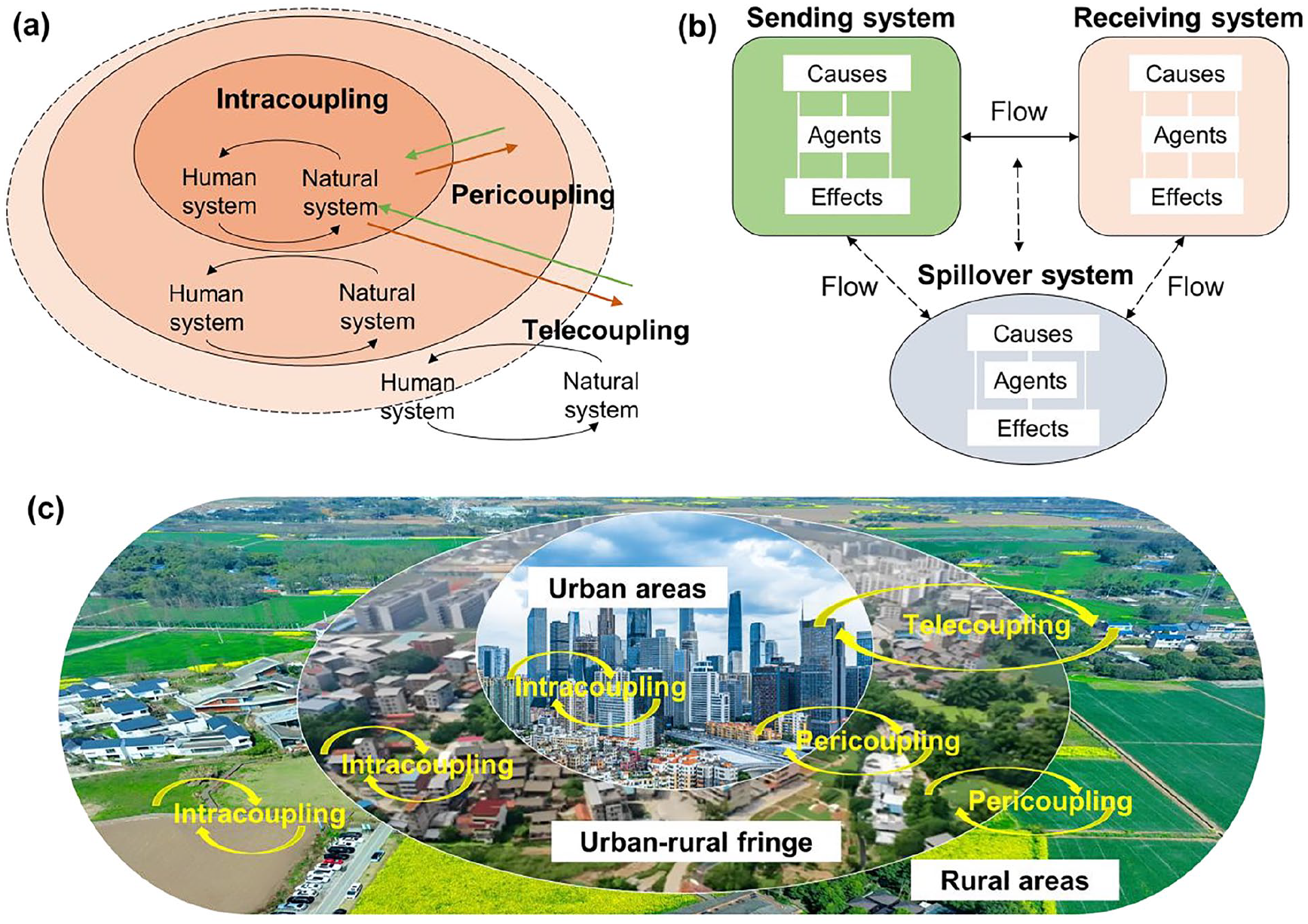
Metacoupling types, framework, and urban-rural interactions diagram. (a) Metacoupling types and human-nature relationships. (b) Telecoupling framework. (c) Urban-rural metacoupling interactions.
Metacoupling interactions for urban-rural ecosystem services supply-flow-demand
Ecosystem services supply-flow-demand nexus and assessment
Ecosystem service supply refers to the quantity of products and services provided by natural ecosystems within a specific temporal and spatial scale (Burkhard et al., 2012). Identifying ecosystem service supply areas and quantitatively assessing their supply potential can provide spatial information and a fundamental basis for ecosystem service management (Shi et al., 2020); Ecosystem service demand refers to the quantity of products and services consumed and utilized by human social systems within a specific temporal and spatial scale (Burkhard et al., 2012). Ecosystem service demand is primarily influenced by factors such as socio-economic conditions, policy-making, and cultural values (Villamagna et al., 2013). On the basis of ecosystem service supply assessments, further clarifying the spatial distribution and demographic structure of ecosystem service demand will help explore the balance between ecosystem service supply and demand (Wu et al., 2023); Ecosystem service flow refers to the process through which ecosystem services, with or without a carrier, are transmitted from the supply area to the benefit area along a certain direction and path, driven by natural or human factors (Bagstad et al., 2013). When exploring the balance relationships between ecosystem service supply and demand, there is a phenomenon where the ecosystem service supply provided by a region cannot meet the human demands within the same space. It is necessary to clarify the entire process of ecosystem service generation, flow, and use, and identify the flow path of ecosystem services from the providing area to the demand or benefit area, i.e., connecting natural ecosystem and human social system in the form of flow (Figure 4).
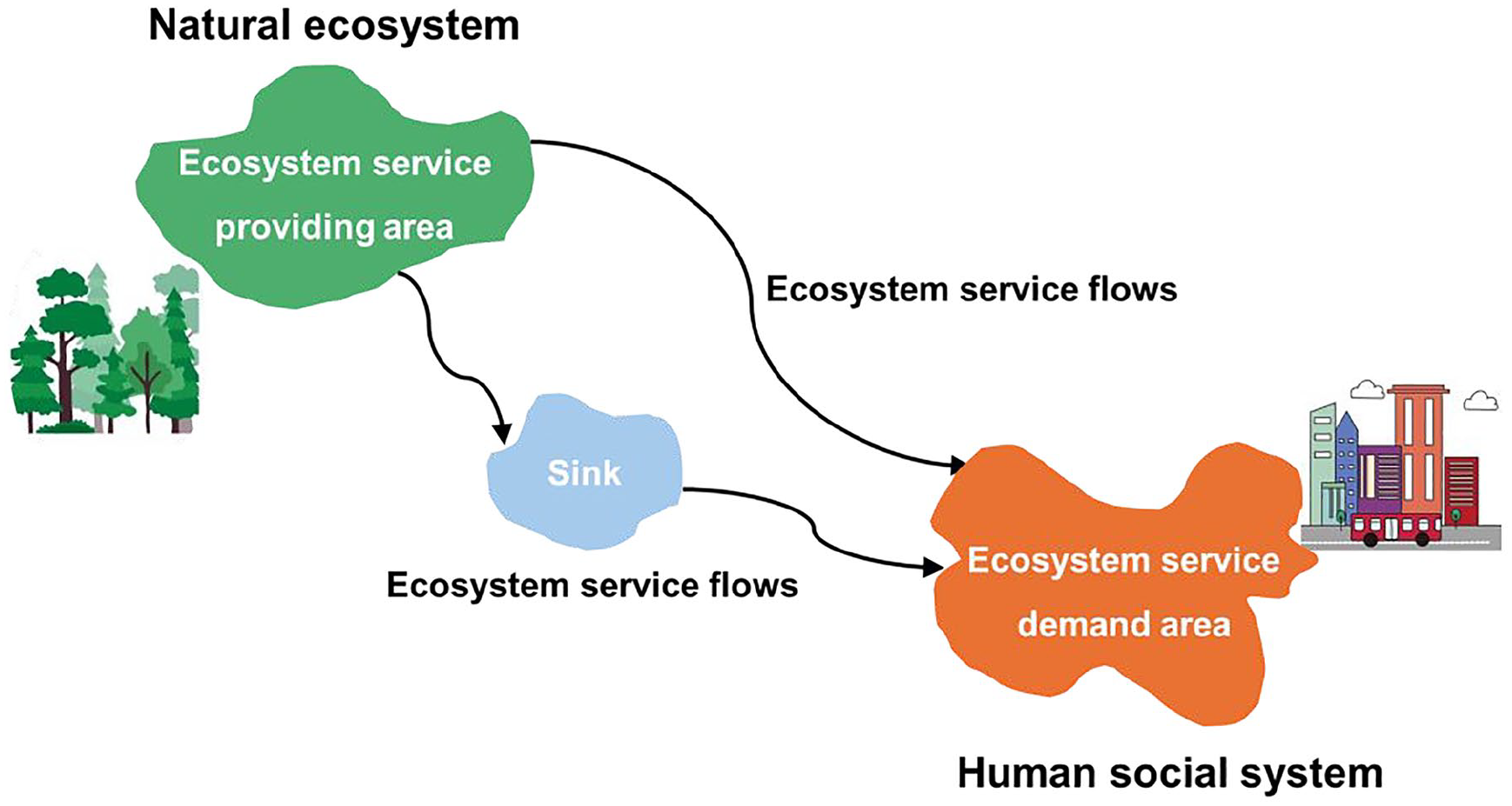
The spatial relationships of ecosystem service supply, flow, and demand.
The biophysical models commonly used for assessing the supply of ecosystem services include InVEST (Integrated Valuation of Ecosystem Services and Tradeoffs) and SolVES (Social Values for Ecosystem Services), which have been applied in various countries and regions worldwide (Goldstein et al., 2012). Ecological process models, such as the SWAT hydrological model, are primarily used to assess water quantity and flood regulation. While these models have broad applicability, they are sensitive to data parameters (Rahman et al., 2022). Other methods, such as the ecological footprint approach, are simple and user-friendly but lack a deep understanding of ecological processes when evaluating the supply of ecosystem services (Mancini et al., 2018). For ecosystem service demand, questionnaire surveys are mostly used to investigate cultural service and payment intention (Sun et al., 2024). The monetary value method mainly calculates the demand of ecosystem services based on parameters such as unit price and area, and is only used to estimate services with market value (De Groot et al., 2012). The empirical statistical method mainly uses population, income and other indicators to reflect the demand. The method is simple, but the data stability is often influenced by the spatial scale (Xu et al., 2022) (Figure 5).
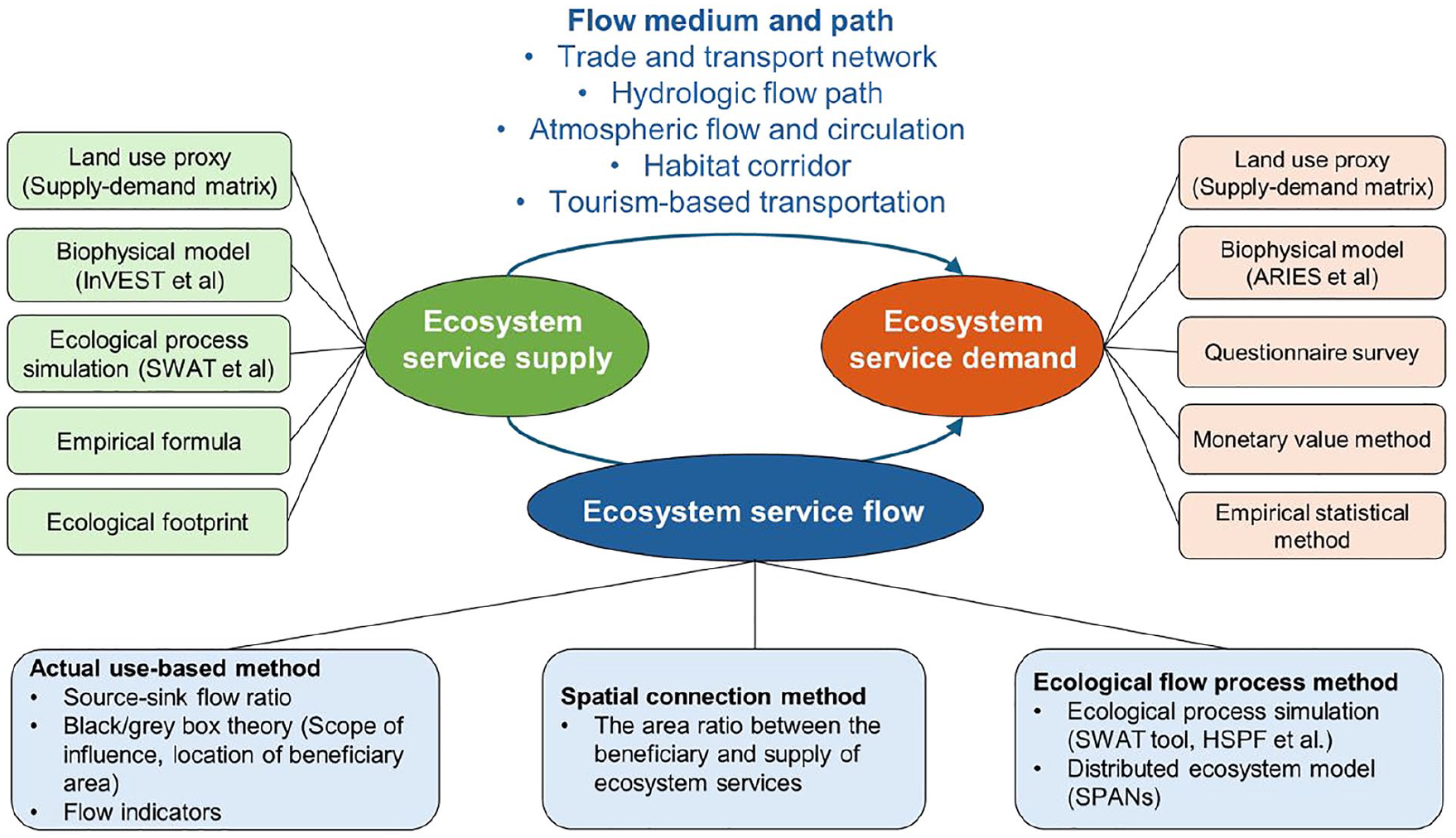
The assessment methods for ecosystem services supply, demand, and flow.
Before assessing the flow of ecosystem services, it is essential to understand the carrier medium and the flow paths. Typically, food supply service flows through trade networks, which are influenced by the means of consumption, market, policies, and other factors. Water supply, water purification, and soil conservation services mainly follow local hydrological flow paths, affected by factors such as the position of upstream and downstream areas, elevation, and river network distribution (Li et al., 2017). Climate regulation and air purification services are mainly mediated by atmospheric flow and circulation, influenced by local climatic factors, topographical conditions, and other factors. Habitat quality service mainly flows through local habitat corridors, usually influenced by landscape connectivity, human disturbances, and other factors. Leisure and recreation services mainly follow local tourism and transportation ways, influenced by factors such as population density, transportation distance, and location of attractions (Figure 5). The assessment of ecosystem service flow primarily includes three categories:
(1) Actual use-based method: this category of method emphasizes the “utility” of ecosystem services and does not consider the intermediate processes of service flow. Instead, it reveals the dynamic changes in the beneficiaries' access to ecosystem services through various data indicators, typically based on actual usage as the flow (Vallecillo et al., 2019). This type of method includes using source-sink flow ratios to reflect the spatial flow of carbon sequestration services (Li et al., 2017), as well as the black/gray box theory to reflect the distribution of ecosystem services from production to consumption. In addition, methods using flow indicators can measure the temporal and spatial changes of a specific indicator on both the supply and demand sides of ecosystem services, thereby determining the extent of service utility acquisition (Xu et al., 2019).
(2) Spatial connection method: this category is mainly based on the spatial connectivity of ecosystem services, similarly without considering the intermediate processes of service flow. It quantifies the flow by calculating the area ratio between the beneficiary and supply areas of ecosystem services. While these methods are useful for obtaining characteristic information about the flow on a large scale, they often overlook the complex processes between ecosystems and human society (Schirpke et al., 2019; Serna-Chavez et al., 2014).
(3) Ecological flow process method: the third category emphasizes the process of ecosystem service delivery, using various geographic information tools to visually simulate the transfer paths and process of ecosystem service supply and demand, in order to establish spatially distributed models. Currently, this mainly involves hydrological models such as SWAT and HSPF (Hydrological Simulation Program FORTRAN), which calculate water flow based on parameters like slope and flow direction (Chen et al., 2020; Lin et al., 2021). Additionally, the Artificial Intelligence for Ecosystem Services (ARIES) project reflects information on sources, sinks, and beneficiaries through conditional probability tables and uses the SPANs (Service Path Attribution Networks) algorithm to simulate the flow paths of ecosystem services from supply points to beneficiary points (Bagstad et al., 2014; Johnson et al., 2012).
Metacoupling interactions for urban-rural ecosystem services supply-flow-demand
Today, ecosystem service research focused on urbanized areas, watersheds, croplands, forests, and parks has become relatively established (Magerl et al., 2022; Palomo et al., 2013). Most of these studies involve the quantitative or qualitative analysis of the ecosystem service supply and demand relationships within administrative regions or watershed units, or the total ecosystem service flow between regions (Kleemann et al., 2020). However, the ecosystem service supply and demand relationships and flow mechanisms within regions, such as urban, urban-rural fringe, and rural areas with different levels of urbanization, are also worth exploring further.
Understanding the supply-flow-demand mechanisms of ecosystem services is helpful for explaining the spatial interactions between urbanized human systems and ruralized natural ecosystems. Exploring the ecosystem services supply and demand across rural-urban gradients or comparing their differences between different urban, urban-rural fringe, and rural areas facilitates an understanding of how urbanization processes and effects affect ecosystem services’ patterns and sustainability (Herrero-Jáuregui et al., 2019; Theodorou et al., 2021). Existing studies mainly consider public perception and evaluation into the decision-making process when evaluating urban-rural ecosystem service demand and paying attention to the differences in preferences of different ecosystem service indicators between urban and rural residents (Rodríguez-Morales et al., 2020; Zhou et al., 2018). However, the heterogeneity characteristics and flow processes of the supply and demand of various ecosystem services between regions with different urbanization levels also should be emphasized (Metzger et al., 2021). Since promoting the smooth flow of urban and rural ecosystem services can effectively alleviate the problem of supply and demand deficit, and the coordinated and sustainable development of urban and rural ecosystem services pays more attention to the difference and flow between urban and rural areas, it is necessary to further explore the coupling interactions of the entire process of supply-flow-demand in the complex urban-rural system.
It is challenging to fully understand and reflect the ecosystem service issues at regional or landscape levels (Wu et al., 2023). Fortunately, the metacoupling framework provides a comprehensive and appropriate set of analytical tools for the assessment and optimization of ecosystem services supply-flow-demand. In this context, the ecosystem service supply area is regarded as the sending system, and the ecosystem service demand area is regarded as the receiving system (Kleemann et al., 2020). The flow between ecosystem service supply and demand areas represents the flow between the sending and receiving systems, while other areas that influence and feedback the ecosystem service supply-demand flow process are considered spillover systems. Based on the spatial relationship between the ecosystem service providing and demand areas, they can be classified into intracoupling, pericoupling (including directional flow and omnidirectional flow), and telecoupling (Tromboni et al., 2021). Based on the proximity of different ecosystem service supply and demand flows, urban-rural coupling ways can be further classified into six types: urban-urban coupling, urban-fringe coupling, urban-rural coupling, fringe-fringe coupling, fringe-rural coupling, and rural-rural coupling. Among them, some ecosystem services between urban and rural areas are directional, such as the flow of food and water resources, while others are bidirectional, such as the flow of air and carbon (Figure 6).
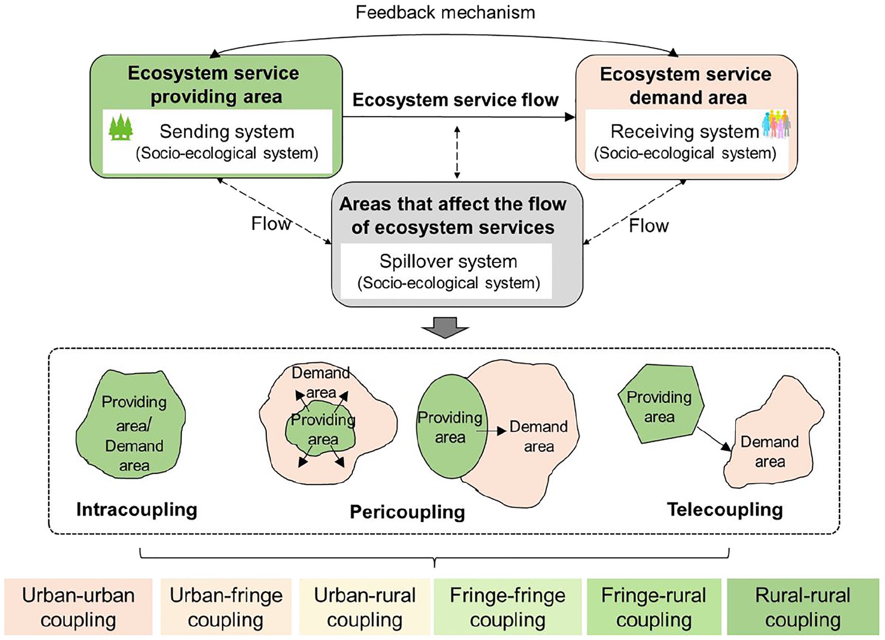
The urban-rural ecosystem service supply-flow-demand diagram based on metacoupling framework.
Optimizing the entire process of ecosystem services by integrating urban-rural metacoupling
Optimizing the entire process of ecosystem services supply-flow-demand
The spatial optimization of the magnitude and paths of ecosystem service flow in urban-rural coupling systems is necessary to effectively address issues such as the inequitable distribution of ecosystem service resources and the smooth flow between urban and rural areas. Unlike most research that focused solely on the optimization of providing areas, metacoupling optimization involves not only the ecosystem services providing areas, but also the demand areas and their associated flows. By identifying the hot spots of ecosystem services supply-demand deficits, as well as the flow size and flow paths of ecosystem services under different urban, rural-urban, and rural metacoupling types, and combining optimization algorithms or models, it is feasible to reduce ecosystem service supply-demand deficits and enhance flow efficiency (Fang et al., 2024b; Schirpke et al., 2019). Among them, in the multi-objective optimization models, the constraints and objectives can be set regarding land use area, economic investment, ecosystem service synergies or trade-offs.
For certain ecosystem services, the physical providing service indicators such as food flow and water resource flow, the optimization scenarios were often designed to minimize the cost of flow paths (Fang et al., 2024a; Wang et al., 2023a). This would be helpful for reducing disruptions or losses in the flow process, while also protecting and restoring critical ecosystem service flow paths, including transport corridors, greenways, waterways, etc. For the regulating service indicators such as climate regulation and water purification, in addition to the fundamental optimization of land use patterns, optimization can also be achieved by incorporating the construction and improvement of ecological corridors such as green spaces, rivers, and wetlands (Long et al., 2024). This promotes the connectivity of these corridors and enhances the quality of natural habitats, allowing natural processes, such as the water cycle, to flow smoothly. Simultaneously, in the detailed design, it is essential to comprehensively consider the water flow paths and air flow directions to improve the efficiency of these flows (Harvey et al., 2019). In the process of optimizing the flow of cultural services, such as the recreational and tourism service, in addition to the flow direction and flow quantity, issues such as flow speed and flow boundaries also should be involved. To enhance residents' accessibility of cultural services, by considering the respective velocities to service destinations or attractions and the reachable boundaries, different transportation modes as well as transportation routes also should be adjusted and designed (Fan et al., 2025).
Taking urban-rural food ecosystem service flow optimization as an example, food flow is a complex process from food surplus areas (e.g., rural areas with extensive distributions of croplands) to food deficit areas (e.g., urban areas with highly concentrated populations and socio-economic activities), involving many stages such as production, harvesting, processing, storage, transportation, and sales. Therefore, the optimization of food flow can be considered from three aspects: supply, demand, and flow sides (Garnett, 2013). The optimization of food supply and demand mainly involves the adjustments to factors such as the cropping structure in production areas and the dietary structure of residents in consumption areas (Singh and Singh, 2017; Springmann et al., 2023; Wang et al., 2022c). This process requires a deep understanding of local agricultural practices, ecological conservation policies, and consumer preferences. It is worth noting that these factors often vary significantly between regions. Compared to the complex process of supply and demand optimization, flow-based optimization focuses on the efficiency and effectiveness of the food supply chain. Flow optimization can ensure the food is transferred from surplus areas to deficit areas in a more sustainable and cost-effective manner and is often considered a more efficient perspective compared to supply-demand optimization (Karakoc and Konar, 2024; Robinson et al., 2016). This type of optimization approach is highly targeted for material flows, such as food flow and water flow, which depend on artificial carriers and physical pathways. The optimization objectives for food flow can be to enhance the overall efficiency of the food supply chain, reduce transport costs, and minimize the accompanying environmental impacts. The optimization approach involves two common aspects: the optimization of flow paths and the optimization of transportation modes. The optimization of flow paths mainly involves determining the optimal transportation routes from production areas to consumption areas, thereby minimizing transportation costs and duration (Prakash and Mitchell, 2018). The optimization of transportation modes primarily focuses on improving overall transportation efficiency and the related costs. Specifically, it is necessary to consider the most adaptive transportation mode for each segment of the transport process, while balancing factors such as transportation costs, time, reliability, and environmental impacts. Additionally, the transfer and transshipment processes between different transportation modes should be considered, aiming to reduce waiting costs and duration (Mazaraki et al., 2020; Zuo et al., 2023).
Promoting ecosystem services optimization with adapting urban-rural metacoupling mechanisms
Sustainable urban-rural development implies the coordination and integration of urban areas, urban-rural fringes, and rural areas, encompassing multiple dimensions of socio-economic and ecological balance and improvement (He et al., 2024). Specifically, the entire process spatial optimization of ecosystem service supply, flow, and demand often involves multiple urban-rural intracoupling, pericoupling, and telecoupling ways (Fang et al., 2024b). In the future, constructing urban-rural ecological security patterns based on the identification of hotspots for ecosystem service supply-flow-demand would be a promising and expandable direction. For urban-rural socio-ecological complexed systems, it is possible to go beyond the traditional “source-to-source” optimization focused solely on ecosystem service supply areas by integrating ecosystem service demand areas and flow pathways to achieve comprehensive “source-flow-sink” optimization.
The management of urban-rural metacoupled systems is mostly implemented at the regional or landscape level (Li et al., 2023b). Especially when it comes to the metacoupling management of ecosystem service supply, demand, and flow, the regional or administrative scale is the appropriate scale for simulating the entire process, scenario simulation, and policy management (Zhang et al., 2023a). When implementing the entire process optimization of urban-rural ecosystem services, in addition to focusing on the supply-demand balance and flow mechanisms, it is also necessary to consider the trade-offs between different ecosystem service supply and demand indicators. Designing multiple alternative scenarios with optimized goals, such as reducing the urban-rural ecosystem service supply-demand deficit, lowering flow costs, and minimizing trade-offs, would contribute to achieving more efficient multi-dimensional management of ecosystem services (Figure 7).
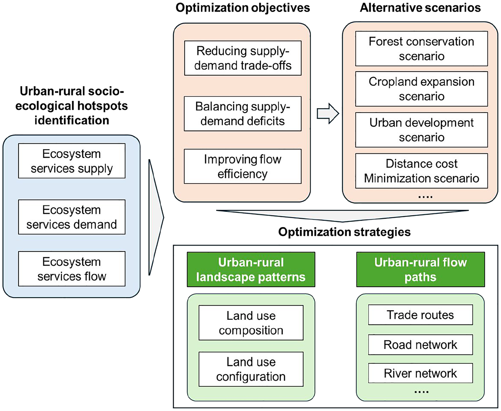
The framework for urban-rural ecosystem services supply-flow-demand optimization.
In addition, ecosystem services are closely linked to the well-being of urban and rural residents. In the process of optimizing ecosystem services, it is also essential to consider the needs and preferences of stakeholders, including institutions and groups, as well as the well-being and perspectives of different urban and rural populations and individuals (Hölting et al., 2020; Sun et al., 2024). For example, divergent recreational ecosystem service demand and landscape preferences were detected across urban-rural residents’ genders, ages, income groups, and other socio-economic factors. Specifically, the needs of vulnerable groups, including elderly and low-income residents should be given priority attention (Riechers et al., 2018). Therefore, the optimization and management of ecosystems in urban and rural areas require adaptive, context-specific approaches, taking into account diverse factors, such as local policies, natural geographical features, socio-cultural traditions, economic development conditions, and the needs of urban and rural residents (Gebre and Gebremedhin, 2019). More importantly, the developed optimization scenarios for urban and rural ecosystem services supply-demand-flow need to be translated into practical and actionable strategies (Figure 7). This requires further integration of ecosystem service optimization strategies with urban-rural land use planning, such as the adjustments to landscape structures, which involve not only the compositions of the landscape but also its spatial configurations. Specifically, the regulation of croplands, forests, and urban lands must strictly comply with requirements such as the ecological conservation redline, the limit of arable land, and urban growth boundary (Asante-Yeboah et al., 2024; Assis et al., 2023). To enhance the efficiency of the metacoupling relationships for urban and rural areas, bridging the ecosystem services flow path, such as developing or reconnecting key trade transport routes, river corridors and networks, designing efficient long-distance greenways and pathways from key provisioning areas to the benefiting areas (e.g., urban centers) would be feasible solutions, especially on the regional level (Sun et al., 2024). In addition, policies related to ecological compensation (Wang et al., 2023b), the construction of ecological infrastructure, and the design of ecological practice projects need to be closely integrated to support the coordinated and sustainable development of the urban-rural socio-ecological system.
However, the optimization framework for the urban-rural ecosystem services supply-flow-demand, based on a metacoupling perspective, that we proposed has several limitations. On the one hand, the proposed research process and framework do not account for scale effects. Typically, the problems such as ecosystem service supply-demand deficits, trade-offs, and flow blockages vary at different scales (Zeng et al., 2024). The key issues related to ecosystem services are often influenced by changes in scale. Considering scale effects is essential to more accurately connect and support the practical management of ecosystem services through theoretical assessments (Norton et al., 2016). On the other hand, the optimization of ecosystem services in different countries, regions, and landscapes is a complex issue, and it is difficult to fully convey the knowledge and information through general theories and frameworks. When assessing and managing ecosystem services, it is crucial to fully consider the local characteristics of the region or landscape (Rodríguez-Robayo et al., 2020), including social and environmental parameters, to implement sustainable optimization that is tailored to the specific context.
Conclusions
Conducting comprehensive ecosystem service assessment and entire process optimization from the perspective of promoting urban-rural integration can effectively enhance the socio-ecological sustainability of urban and rural regions. Ecosystem service flow can effectively connect supply and demand, helping us understand the coupling mechanisms of the entire process from supply to flow to demand. The metacoupling framework provides an adaptive theoretical approach for understanding ecosystem services supply-flow-demand relationships and mechanisms. In light of this, this study focuses on two key issues: first, it interpreted the urban-rural socio-ecological system coupling relationships and their ecosystem service supply-flow-demand relationships; second, it developed a metacoupling methodological framework for spatial optimization of ecosystem services based on the entire supply-flow-demand process. Among them, for urban-rural complex systems, we focus on incorporating urban-rural fringe as a key and important area for management. This study provided a comprehensive understanding and exploration of the urban-rural ecosystem services supply-flow-demand relationships and their metacoupling spatial optimization. It not only helps promote a balanced supply and demand of ecosystem services and effective flow between urban, urban-rural fringe, and rural regions, but also further supports the integration of ecosystem service management into practical decision-making.
Footnotes
Declaration of conflicting interests
The author(s) declared no potential conflicts of interest with respect to the research, authorship, and/or publication of this article.
Funding
The author(s) disclosed receipt of the following financial support for the research, authorship, and/or publication of this article: This work was supported by the National Natural Science Foundation of China: (Grant No. 42271113), National Key Research and Development Program of China: (Grant No. 2022YFD2001105), and Young Elite Scientist Sponsorship Program by Cast: (Grant No. 2021QNRC001).