
Abstract
Informal settlements are characterised by inadequate infrastructure and overcrowding. Making up a major portion of the urban fabric of Asia, they are the result of ineffective policies, unsuitable regulations and a lack of political will. Informal settlements are vulnerable to climate hazards, burdened with land tenure insecurity and dependence on the informal economy for livelihoods. As they expand, coastal informal settlements occupy environmentally vulnerable spaces, such as low-lying marshy swamps alongside water. The most frequent risk is flooding, which is made worse by sea-level rise and excessive precipitation brought on by climate change. In the absence of adequate institutional interventions and exacerbated by the impact of climate change, inhabitants are forced to develop local parsimonious coping strategies to forge a harmonious coexistence with water. The objective of the article is to find space for water, that is, identifying physical space that serves for flood adaptation within informal settlements. This involves spatial assessment of embedded shared space in informal settlements. Spatial analysis based on the occupation of space and its relation with water is carried out through drawings, direct observations and interpretation from the cases of Dharavi in Mumbai, India, and Dili in Timor-Leste. The findings reveal the intricate relation between water and informal settlements, laying the groundwork for a proposition of typologies for water-related public spaces that could be of significant use for formulating flood adaptation strategies.
Introduction
A substantial proportion of Asia’s urban population resides in informal settlements, making up a significant element of the urban fabric. Despite a global decline in the percentage of urban population living in slums from 46.2 per cent in 1990 to 29.7 per cent in 2014, developing countries have witnessed a rise in slum dwellers, with over 880 million people in 2014 compared to 791 million in 2000 (UN Habitat, 2016). This underscores the need for efforts directed towards informal settlements in developing countries. Factors such as a dearth of political commitment, corrupt practices, deficient land markets and flawed policies contribute to the formation of these settlements (Carrasco & Dangol, 2019). The inhabitants, underprivileged in many ways, occupy sites based on intricate power dynamics and interests, often settling in overlooked or neglected areas (Carrasco & Dangol, 2019). As noted by Porter (2011, p. 116, in Ahlers et al., 2014), it is essential to recognise that informality is not external to formal systems; rather, it is intricately woven into and produced by formal structures, highlighting the imperative for a concentrated effort in addressing informal settlements within the broader urban context in Asia.
Nowhere is it more urgent to consider public space in relation to climate than in the cities of the global South (Sahakian et al., 2020, p. 91). Flooding is the most common hazard, with 35.4 million people affected by floods in 2018 (UNISDR, 2019). Furthermore, climate change is expected to bring an increase in extreme weather events with larger volumes of precipitation, with sea-level rise (SLR) increasing risk levels. The IPCC 2014 report states that: ‘Coastal systems and low-lying areas will increasingly experience submergence, flooding, and erosion throughout the 21st century and beyond, due to sea level rise’ and ‘approximately 70% of the coastlines worldwide are projected to experience sea level change within 20% of the global mean’ (Pachauri et al., 2014, pp. 60, 74). The inception of an informal settlement and the process of its spatial configuration, as an individual or collective movement, generally ignore the area’s topographical characteristics, thus increasing environmental vulnerability. Coastal informal communities inhabit low-lying grounds and marshes along the river and water lines as they grow with rising populations. The two sites being analysed in this study, Dharavi in Mumbai, India, and Dili in Timor-Leste, are cyclically vulnerable to floods, which have been further exacerbated by climate change. The impact of SLR on these two low-lying areas (see Figure 5) increases flooding with a particular incidence in the areas where the most vulnerable communities can be found. In Dili, projections indicate that SLR can be between 0.08 m and 0.36 m by 2050, emphasising that these will be above the global average (Australian Bureau of Meteorology and CSIRO, 2011; CSIRO & SPREP, 2021) Dharavi’s projected SLR values, included in the values for Mumbai, are of circa 0.1 m and 0.3 m for the same period (Vaidya, 2023).
Flooding is a result of not only persistent rain and severe weather occurrences but also the impact of urban constructions, in this case, informal settlements. Meteorological, hydrological and human factors interact in different ways to cause a flood (Matos Silva, 2016, p. 81). While urban experts trained in different disciplines can make informed decisions and evaluate risks based on scientific information, those depending on perceived risk will make decisions based on their anticipation of what the future will be, based upon past experiences and the context that surrounds them (Adams, 1995). The perceptions among the most vulnerable people living in informal settlements are informed by their immediate needs and their access to information. Their priorities are connected to the provision of shelter, livelihoods to support their households and their access to space. Thus, the location of informal settlements is the result of choices available to them and their ability to meet their basic needs. Access and proximity to water can be seen as a source of income, food and transport, which determine the daily activities of dwellers. The spatial characteristics of an informal settlement are the result of the process of how the settlement is created over the years. Like all human environments, settlements are not spontaneously created; rather, they are built, with deliberate changes to the physical environment being made through a sequence of decisions based on available options (Rapoport, 1988, p. 52). The natural settings of cities play a significant role in shaping the initial conditions for the formation and spatial configuration of informal settlements. Factors such as land relief, soil quality, climate, solar and wind exposure, and the characteristics of the natural landscape all influence how a settlement evolves. This process encompasses everything from the establishment of the informal settlement, the creation of initial paths and streets, to the subsequent development of infrastructure within these streets, the division of land into different parts, the construction of various buildings on these plots and even the materials used for construction (Oliveira, 2016). Informal settlements expand due to complex interactions involving various human entities, including households, businesses and the government, along with biophysical factors such as regional geomorphology, climate and natural disturbances. These interactions result in diverse patterns of infrastructure density, land use and overall development (Marzluff et al., 2008) within the informal settlements that are closely tied to the effectiveness of the continual local adaptation towards addressing climate-related risks, particularly changing water levels over time.
Through a spatial analysis of embedded shared space in informal settlements, this article seeks to find space for water. An analysis is done by developing cross-sectional drawings, observations and interpretations from direct fieldwork while examining the formation of Dharavi and Dili. Based on how space is used in connection to water, this analysis enables the identification of spatial characteristics. In the scope of this article, we define public spaces as places where communities can gather, where access is for all, and where there are no restrictions based on property and places that serve social purposes. We subscribe to the position, presented by Sahakian et al. (2020), of public spaces as places that are fundamental for ‘sustainable wellbeing’, namely that they respond to the needs and benefits of both individuals and societies, encompassing aspects such as ‘social inclusion, democratic engagement, and opportunities for leisure and livelihood generation’ (Sahakian et al., 2020). For this analysis, the researchers thus follow UN Habitat’s (2018) definition of public space that may be considered to be parks, streets, sidewalks and footpaths connecting these and other elements such as places of leisure, goods transactions and service provision, as well as spaces between buildings or roadsides. The authors have added water-related shared public spaces to this list to broaden its scope, particularly those where there are conflicts in the use of space in informal settlements.
Acknowledging that there is competition for space in most of the global South, we note that the existence of competing values and needs, mismanaged or ignored by governments, often leads to increasing vulnerability. Yet, the analysis of shared public spaces also shows how they are spaces of coexistence, through adaptation strategies and explorations of possibilities to respond to the needs of dwellers, while in harmony with water. It is in this mixed space of shared and conflicting uses that we focus our analysis. The results provide a relationship matrix between the shared space, the elements and water that exist in the informal settlements. This assessment provides a base from which to critically assess the significance of shared spaces and allows for an elaboration of responses towards flood adaptation and the competing needs of public space for water among dwellers of coastal informal settlements. The article aims to integrate morphological analysis with assessments of local adaptive capacity and resilience to determine the potential of local urban actors, especially by examining the shared use of space between water and residents. The emphasis is on active community participation in local initiatives as community-based adaptation.
The overlooked sites of Dharavi and Dili are both located in the global South (Figure 1), and despite differences in territorial scale and population, they are justifiably comparable because of their proximity to water and the conflict of use of space between water and human occupation.
Context
Cin et al. (2021) refer to the identity of cities on water bodies as being greatly focused on water given that the establishment of the city itself is the result of a choice by communities and authorities—colonial or otherwise. These were often the result of geomorphological characteristics such as resources for subsistence and livelihoods, cultural activities, trade and transport. The examination of the overlooked sites of Dharavi in Mumbai and Dili in Timor-Leste is motivated by their shared characteristics and challenges, despite differences in territorial scale and population (Figure 1). Both locations are situated near water, making them comparable in terms of having shared space between human occupation and water. The genesis of these cities dates back to colonial times, when the establishment of settlements was influenced by the recognition of water as both a problem and an opportunity for the communities (Boavida, 2011). However, historical decisions did not adequately account for the vulnerability of these communities to the risks associated with changing water presence and levels. Both Dharavi and Dili face ongoing challenges and limitations due to the lack of formal risk reduction measures from various levels of governments, leading to an absence of safety and security for basic immediate needs.
Location of Cases: (a) Dharavi in Mumbai and (b) Dili in Timor-Leste.

Water has an undeniable influence on the development of the informal settlements of Dharavi and Dili. Not only do these settlements have an extensive waterfront, but the water and its flow must be at the heart of the decisions in the occupation of these territories. Here, it is particularly important to note that these settlements are also characterised by their low-lying and flat topography that promotes the accumulation of water when it flows through the city and in particular during the monsoon period. Furthermore, these settlements were established on an island of alluvial land, which has a direct connection to the different sources of water in the territory. Thus, the fact that the settlements are situated so closely to the sea is significant in this perspective.
Dharavi, Mumbai
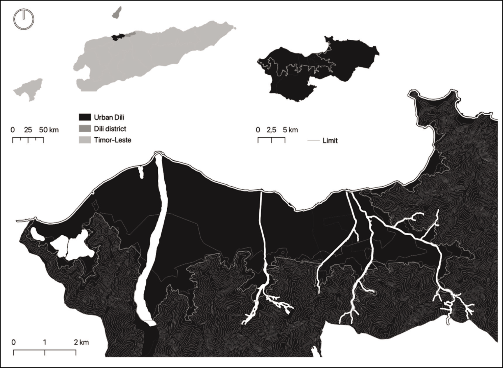
Mumbai, a city situated on the west coast of India, was once a collection of seven marshy islands. It now occupies a long, narrow peninsula in the Arabian Sea. According to the 2011 Census of India, informal settlements make up about 55 per cent of Mumbai’s population. They are typically found in low-lying areas near marshes and other marginal sites. Dharavi is a slum located along the Mithi River. Since its early inception in the eighteenth century, it originated as a ‘hidden’ slum on the edge of the city due to its strategic location in proximity to water. Mumbai’s integral railway line along the Dharavi slum provides a convenient commute for slum dwellers to other parts of the city. The physical and spatial organisation of the territory and its relationship with water are directly impacted by this position. The informal settlement that occupied low-lying marshy land, unsuitable for formal development, now lies in the centre of metropolitan Mumbai, as illustrated in Figure 2.
Location of Dharavi in the Island City of Mumbai and Its Relationship with Water.
An estimated 1 million people live in Dharavi, the largest informal settlement in Mumbai and the largest slum in Asia (World Population Review, 2024), with a population density of 277,136 people/km2 in comparison to Mumbai’s overall density of 28,185 people/km2. Throughout the making of Dharavi, the water and community network has contributed towards communal sectorisation according to livelihood and has thus driven spatial configuration. The evolution of Dharavi is illustrated in Figure 4.
In the 1800s, a small fishing village of the Kolis (a fishing community) stood where Dharavi stands today. This was followed by the reclamation of marshy lands and a massive in-rush of dwellers. The first instance of Dharavi’s resemblance to its present form began to shape in the late nineteenth century with the setting up of industries. Dharavi is composed of significant shared public spaces similar to formal neighbourhoods. It is made up of open spaces, such as maidans, squares, a fort built during the British era called Riwa, a sizeable cremation ground and river basin space, among others. People near the water engage in indigenous livelihood activities in these communal areas. In this informal settlement, there is a dependence on public space as an extension of private life, which ensures a high usage of all available public space. In Dharavi, the streets are adapted for diverse social functions and economic activities, with public spaces being utilised to support economic livelihoods and foster connections with the formal city of Mumbai. This dynamic use of space plays a crucial role in shaping the spatial configuration of Dharavi.
Historically, the monsoon season, which lasts from June to September, brings roughly 220 cm of rain to Mumbai each year. According to Patankar (2015), the average annual rainfall has grown to more than 240 cm since 2004. The year 2005 saw the most significant rainfall. Dharavi is a victim of recurring floods, being environmentally susceptible due to its geographical location and lacking the capacity to absorb and prevent floods. Dharavi has evolved over time in response to the ongoing conflicts between bottom-up spatial adaptation measures and top-down urban policies, particularly in its efforts to address flood hazards (Goyal et al., 2023).
Dili, Timor-Leste
Dili, the capital city of Timor-Leste, is located on the northern coast of the island of Timor, overlooking the Ombai Strait. The Portuguese arrived in Dili due to its protected bay, offering protection to boats from different places during windy and rainy seasons. The ruler of Motael gave permission to the Portuguese, the sandalwood merchants, to remain there. Portuguese colonial immigrants recognised the advantages of water availability for agricultural development when they settled in what was once a small fishing community with the sea to the north and a large plain to the south, where swamps and other water bodies existed, and with rice fields to the west. The settlement slowly gained structure and grew into the city of Dili (Ximenes Belo, 2014) and in 1769 became known as the Praça de Dilly after the Portuguese established it as the new capital of Portuguese Timor.
The 2015 Census noted that the municipality of Dili was home to 277,279 people, the equivalent to circa 23 per cent of the national population. Of these, 244,584 lived in areas considered urban (approximately 70 per cent of the total urban population of the country). The urban population density in Dili was 4,083.1 people/km2, whereas at the national level, the urban population density was 1,271.3 people/km2. Urban Dili occupies 59.90 km2 of the total 364.12 km2 of the municipality of Dili (Government of Timor-Leste, 2015).
Located circa 8º south of the equator, the climate of Dili is a monsoon regime, a period that most often occurs between November and April, rarely going over 150 mm per month (FA.UTL, 2002) and an annual average of 850 mm (Costa, 1966). The city’s growth is limited by its geography to the south, east and west, by the water lines that cross it and create hurdles to its extension, and by the sea, to its north (Figure 3).
Dili has developed around the presence of water. This can be seen through the morphology of the city and its lining up along the waterways and the natural coastline—with its expansion from the north to the south along seasonal water lines and water infrastructure. The city was first developed by the Portuguese and its planned layout is a classical octagonal Portuguese colonial urban form (Proença, 2007). The first point of connection between Dili and water is in the existence of the city in itself—the city was established because of its natural port, protected by coral banks and the possibility of sustaining fertility in its soils and providing access to water for its inhabitants (Boavida, 2011). Yet, while water provided sustenance and protection for the city, it also contributed to the issues surrounding the environmental health of the city, with mountains acting as barriers to the circulation of air and the existence of swamps concentrating mosquitoes and dissemination of illnesses such as malaria (Aguiar, 1951). In terms of the issues related to environmental health, several plans were made to try to regularise water flow through the construction of drainage channels, testing different solutions, reducing natural meanders and establishing a more direct path for water flow (Boavida, 2011).
The increasing informal occupation of the territory, coupled with soil impermeability and inadequate water retention in the surrounding areas due to deforestation and accentuated urbanisation over the past 20 years, along with insufficient management of drainage infrastructure, has resulted in a rise in flood occurrences (JICA et al., 2016). These events now impact a broader expanse of regions and a greater number of people each year. The riverside occupation of channels associated with livelihoods and densification of areas as people move to the city and build new homes in environmentally sensitive areas, has seen an increasing number of people affected by the floods. The worst flood event in Dili was recorded in April 2021, affecting the whole city and leading to widespread infrastructural destruction, loss of lives and livelihoods, and displacement of many families from their homes (Government of Timor-Leste, 2021). Such floods had only been experienced in the 1970s, yet in 2020, the floods also hit parts of the city with significant levels of destruction. Since then, many homes have been rebuilt on these same sites. Public space in Dili has been encroached by human occupation, particularly on the margins of the main waterbodies that cross the city and the environmentally sensitive area of Tasi Tolu (three lagoons) to the west of the city (see Figure 3).
Method
Context Analysis and Systematisation
The study employs a comprehensive analysis of various contexts within informal settlements to assess and create a systematisation of the use of spaces, while considering how these reflect on the ability of communities to adapt. By direct observations and examining local strategies developed by the communities, we aim to recognise their significance in enhancing the capacity to live with water. The findings indicate that these communities have identified and adapted spaces within the assessed territories to coexist harmoniously with water through constant adaptation to their changing environment, while also seeking access to the city, despite an absence of assured protection from the challenges and risks of their vulnerable living conditions.
Field Observations and Data Collection
As an exploratory exercise, this article makes use of direct field observations conducted at both sites over multiple periods between 2019 and 2023. This work is drawn from the research projects titled ‘Shaped by Water and Parsimony: A Lexicon for Urban Slums Adaptation in the Global South from the Dharavi Case’ and ‘Risks & Opportunities in Ordering the Post-conflict Disorder: Lessons from Dili, Timor-Leste’, at CIAUD, Research Centre for Architecture, Urbanism and Design, Lisbon School of Architecture, Universidade de Lisboa. Observations were carried out in Dharavi, Mumbai, and Dili, Timor-Leste, chosen for their distinct environmental and socio-economic characteristics. These sites were selected based on criteria such as vulnerability to flooding, proximity to water bodies, and the presence of established informal settlements. The observations were meticulously registered using drawings, photographs and videos at different moments to capture the experiences and perspectives, which present the spatial configurations and cyclical occupation between the slum dwellers and water in the adapted spaces within assessed territories. Additionally, it incorporates the review of pertinent state-of-the-art knowledge to articulate the water-related elements in the shared space of informal settlements and the cyclical adaptations in different seasons.
The reflections are further enriched by informal discussion at local gathering spots with local residents, based on their involvement with, experiences in or impact of the water-related challenges within the assessed territories. By ‘informal discussions’, we refer to casual, yet insightful conversations that took place in community public spaces, such as squares, streets and with local vendors. These interactions provided valuable, on-the-ground perspectives on how residents perceive and respond to water-related issues. Notably, similar issues were observed in a study conducted after the extreme July 2005 flood in Dharavi, where slum dwellers reported their homes being submerged annually during the monsoon season due to flood incidents (Patankar, 2015). Analyses of these observations and discussions combined with reviews of climate change reports, vulnerability studies and relevant literature provided the base for assessing space considering occupations and daily activities of the dwellers in these shared spaces. The article thus represents the exploration of this relationship and the conflicts that arise from dwellers sharing space with water in coastal informal settlements with perceptions of threat, opportunity and adaptive ability.
Typological Analysis
The cases are examined both individually and collectively, focusing on the reflections and intermingling of existing typologies, in an effort to find similarities in the analysis. We look at the relationship matrix and reflect on the space in relation to water—namely in terms of the relationship between the space and the kind of water body as well as the type of conflict that exists. The different relationships with this water body are analysed, namely if it is ‘near’ (public space along the shoreline), ‘in’ (amphibious public space which functions in flooded situations), or ‘on’ the water (floating public space) (Aguiar, 1951, p. 6). The relationship of water-related elements in the shared space of informal settlements and the cyclical adaptations in different seasons of the year is presented with cross-sectional drawings derived from the cases analysed.
Results and Discussion
Role of Water in Evolution and Development of the Settlements
While assessing the development and expansion of the settlements in time, we note that water has had a significant influence. Figure 4 illustrates how water has influenced both Dharavi and Dili in terms of opportunities and threats.
In these settlements, water (river and sea) is relevant not only to the establishment of settlements but also to their development. The presence of ports, for instance (to which the establishment of the settlements is owed), has led to economic growth, environmental relevance and accessibility, with the structure of the settlements developed around the sea. Water-related shared spaces also offer an area for culture and leisure, such as sporting activities, for dwellers as well as for tourism. These are also areas of local adaptation to address the risk of floods.
Risks and Challenges
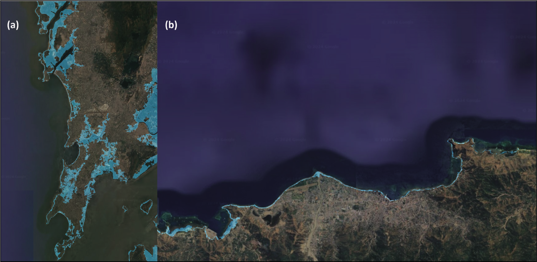
Water also presents significant risks, given the topography of these coastal informal settlements. Storms and increased incidence of hurricanes, as seen in Figure 5, demonstrate the impact of SLR for the cities containing Dharavi and Dili, in a moderate scenario proposed by Kopp 1 for the climate central modelling tool.
Projected SLR—2050: (a) Mumbai, in 2050; (b) Dili in 2050 (http://www.climatecentral.org /, accessed on 23 July 2021).
The form of the two sites has a close relationship with swamps and marshes. As noted above, both settlements, although different in the scale of the territories, were established around the presence of these water bodies, recognised in different urban initiatives and identified as problematic elements of the territory, presenting risks and problems (Aguiar, 1951; Boavida, 2011; GERTiL, 2005). These neglected low marshy sites are vulnerable to floods and have been occupied by informal settlements in Dharavi and Dili. In both cases, it is worth noting that periodic redevelopment plans also mention that local ‘indigenous’ communities were living in these sites of greater vulnerability (Aguiar, 1951; Boavida, 2011; Campos, 1972). There have been several formal and community-led attempts to improve these informal settlements, including cleaning of drainage channels and draining the swamps, improvement of drainage networks for addressing floods and building flood resilience over time. In Dili, the 1834 plans made reference to the need for improvements in the drainage of the city. The 1972 urban plan for the city of Dili also highlighted areas of recurring floods, and since the days of the UN Transitional Administration for East Timor (1999–2002) and subsequent reestablishment of independence (2002 onwards), different development partners have supported the development of drainage plans for the city, without significant success (JICA et al., 2016). Consequently, much of the structuring of the city is shaped around this infrastructure, whereby the plans developed during the colonial period refer to the centrality of the swamps in the life of the population and all urban development. This type of risk was always present in both cases, where the low-lying occupied marshy lands near waterways are at high risk, with lower quality of housing and water drainage infrastructure (Goyal & Silva, 2024). Additionally, these are areas of vulnerable environmental health, prone to health hazards given the concentration of mosquitoes that transmit malaria, dengue and other diseases. Topographically, Dharavi and Dili have a great predisposition to flooding and demonstrate flood adaptation initiatives similar to other coastal informal settlements (Goyal & Silva, 2024). The reasons for flooding and associated issues, risks and vulnerabilities are similar in both cases. They are primarily caused by insufficient drainage systems (URBZ, 2020), clogged water lines (Patankar, 2015) and obstructed drainage channels due to the accumulation of waste, impacts of various forms of livelihoods, and changes to river channels that are used as pathways for both pedestrians and vehicles. These are further aggravated by high levels of urbanisation and the consequent impermeabilisation of the ground (Almeida et al., 2015) that are echoed in previous analyses carried out in both sites (Goyal & Silva, 2024).
Adaptation and Conflict in Shared Public Spaces
It is, therefore, significant to examine the shared public space between water and anthropic use. This shared space must also be seen as a place for everyday activities and flood adaptation in informal settlements. Thus, despite the risks they pose, these spaces offer opportunities for use, often complementing inadequacies in homes, and providing a new kind of infrastructure where the formal infrastructure is missing. Sharing the space in such a manner may offer opportunities while addressing the flood risk and generating potential conflicts between the different uses and accesses.
This discussion also needs to frame the importance of access to public space on sites of informality. Cobbinah et al. (2021) note the importance of access to and availability of public space for the health of cities. It is also noted that greater importance is awarded to the fact that slums proliferate and the inadequate housing in slums, setting aside the importance and relevance of public space. Research in different locations such as in Ghana and South Africa (Cobbinah et al., 2021) demonstrates that the responses of communities in informal settlements on the importance of public space indicate that their significance is perceived to be connected to socio-cultural practices and needs as well as to physical urban aspects—be it for health, to reduce vulnerability or for aesthetic value. The evidence presented indicates that the lack of local involvement in the planning and maintenance of public spaces and the failure to recognise and integrate local authorities, such as community leaders and local councils, into development projects cause significant degradation in the living environment in these areas. This degradation subsequently places the communities under greater vulnerable conditions. The need to maintain these spaces is also relevant in the provision of improved security conditions for the communities. This is particularly important in ensuring that these spaces are available for community use, for instance, for youth groups to socialise and meet.
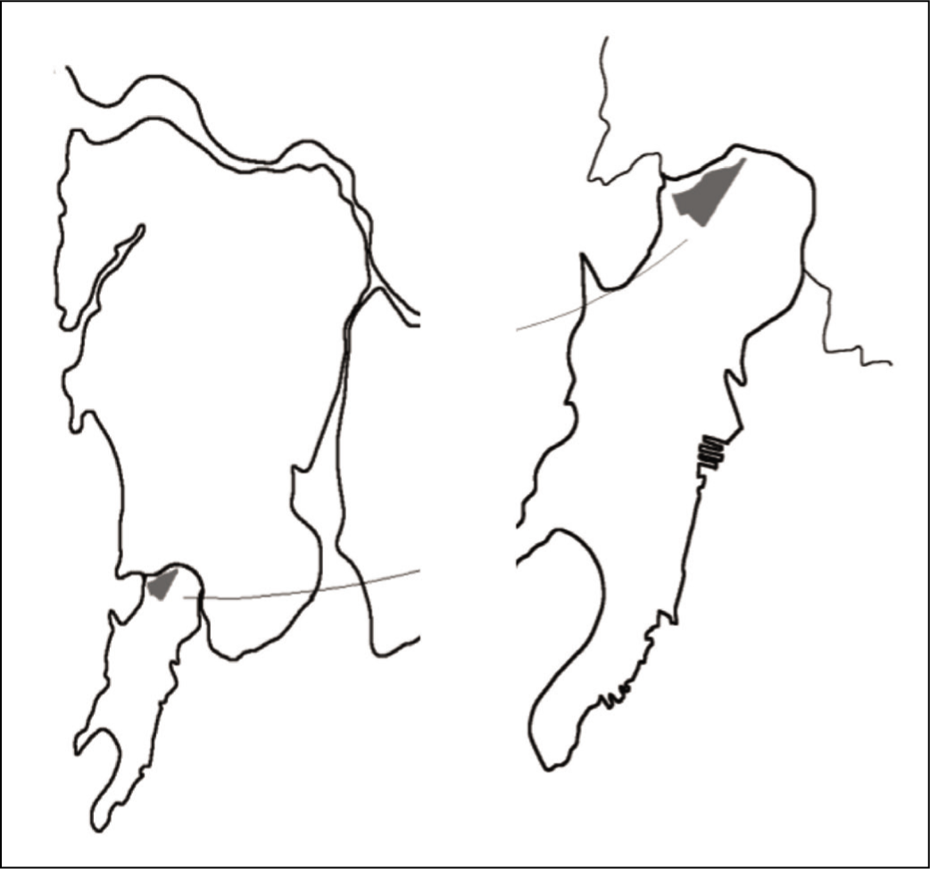
In the case of Dharavi, the space above the water drainage pipes is used as a pedestrian walkway to cross the Mithi River. Below the pipes, there is a shaded liveable space, a playground for children during the dry summer season and water in the monsoon seasons. The same water pipes also provide an access route to the informal houses on stilts in the river catchment (Goyal & Silva, 2024). The conflict and this shared use of public space are illustrated in Figure 6(a). In a similar context, the waterways provide for water throughout the year and housing on stilts, as illustrated in Figure 6(b). This is evidence of the constant adaptation to the use of space in close relation to water.
Cross-section Illustrating the Conflict and Shared Use of Public Space During Dry (Left Illustration: Between September and June) and Wet (Right Illustration: Between June and August) Seasons as Significant Flood Adaptation in Harmony with Water in Dharavi, Mumbai, and Dili, Timor-Leste. (a) Shared Use and Conflicts in Dharavi’s Public Space along Mithi River; (b) Continuous Adaptation in the Space of Water Lines in Dharavi; (c) and (d) Adaptation in the Riverbed Space in Dili, Timor-Leste.
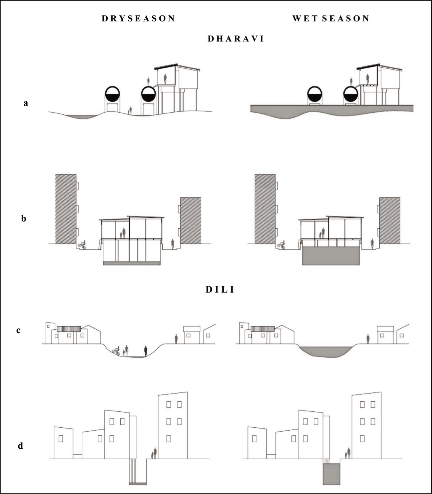
The cross-sections presented in Figure 6(c) and (d) illustrate examples of sharing spaces that take place in Dili. They show the use of the riverbeds by children in the dry season, who use it as a playground in a place where parks and playgrounds are missing and where backyards do not exist. It also shows how the riverbed is often used as a road by pedestrians, cyclists and those on motorbikes.
It is also observed, in both cases, that the water body is a place where rubbish accumulates amid inadequate waste management policies and that considering poor sanitation systems, this area may also be a place of great vulnerability to disease, particularly in the heat and humidity of the monsoon. It is also important to remember that the existence of rubbish in waterways may lead to the blocking of water passages, which causes further exacerbation of the flooding of the riverbanks. These have been some of the key issues in the floods of recent years since 2005 (Goyal, 2021).
Furthermore, as was observed on-site, the construction of homes or the presence of housing infrastructure has a close association with water infrastructure in both cases. In homes built right on the edge of available space, local adaptation strategies are developed, with the houses being built on water drains to support the walls or to support outside space that is used as a meeting place. In other cases, bridges were built over water drains to provide access to homes. This appropriation of public space leads to significant conflicts during heavy rains, when the water can easily destroy and displace the use of these shared public spaces. These conflicts often arise between residents who use the spaces for meeting and socialising and the changing water. Spaces shared with water are also used to produce food. In Dili, local communities use some drainage channels and areas surrounding swamps on which they built their homes, to grow kang kung (Chinese water spinach). In Dharavi, the water channels were also observed to be used for laundry and bathing, thus providing for economic opportunities. Noting the poverty of such communities, the dwellers have adapted their way of occupying these areas where they established themselves by producing and selling these goods across the city and transforming infrastructure into forms of livelihood. However, this same use of the space of production has also led to the malfunctioning of the drainage channels and the swamps themselves leading to retention of water and increased issues of environmental health. In both cases, it is found that in the absence of a larger number of formal spaces of leisure and of public use, there is an appropriation of public infrastructural space and of routes of water to make use of as spaces of interaction and used as public space.
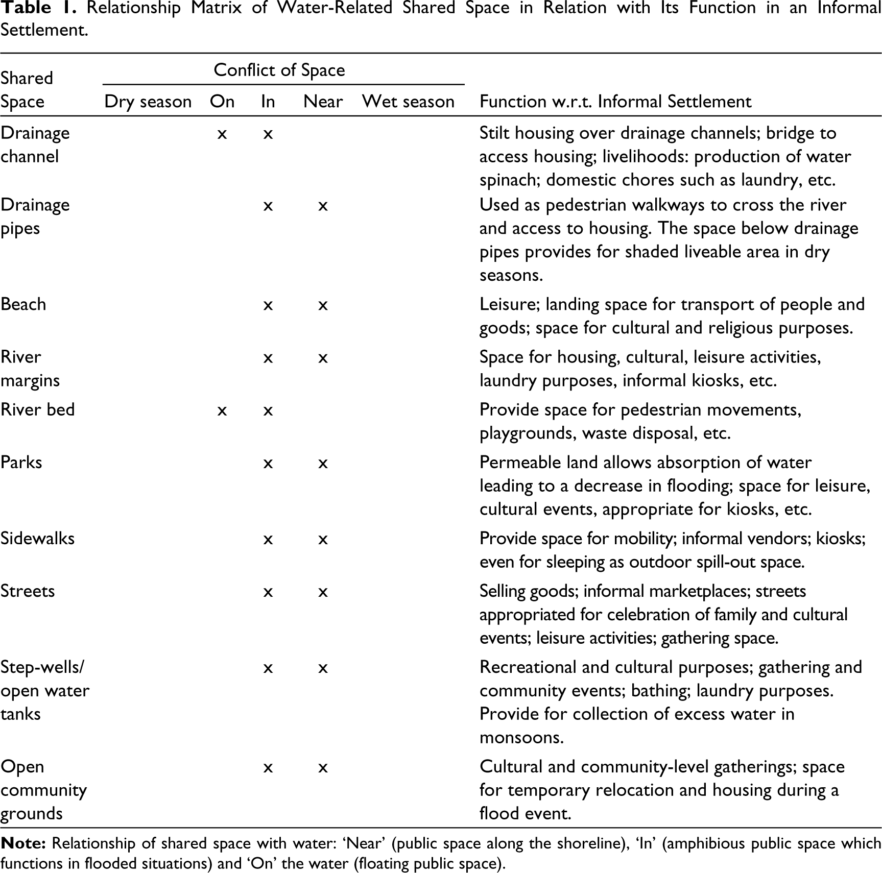
Table 1 illustrates the relationship matrix of shared space in relation with water and its function in an informal settlement, as derived from the assessment of the cases.
Relationship Matrix of Water-Related Shared Space in Relation with Its Function in an Informal Settlement.
Typology for Planning for Future Resilience
As seen in Table 1, most of the shared space categories fall within an ‘in’ amphibious space, that is, areas that have a strong mixed use between water and anthropic use, feeding into the significant vulnerability of the two sites. These public spaces support livelihoods, play important functions in water management and protection and provide space for flood adaptation. Therefore, it is essential that these communities receive attention from local governments. Such attention should include the development of infrastructure that can accommodate mixed-use spaces, policies that protect and enhance these areas, and community engagement initiatives to ensure that the needs and practices of the residents are understood and supported. Efficient application of local community-led adaptive solutions along with the ability of public space in addressing floods can provide for building future flood-resilient informal settlements. The mixed use of space, meaning the overlapping and shared utilisation of areas by both water and human activities, is necessary in these settlements. The mixed use, which often leads to conflict over space, must be managed and planned for to address the challenges posed by extreme weather events and SLR as illustrated in Figure 5. Through creative planning and accommodating both water-related and anthropic uses, it is possible to implement flood adaptation measures and improve water management. This approach helps protect the identity, characteristics, livelihoods and safety of the informal settlements, ensuring they are resilient in the face of environmental changes.
For the shared space categories in a ‘near’ relationship with water, safeguarding the shorelines and margins of the water bodies needs to be prioritised. What can often be thought of as a somewhat fuzzy boundary, that is, indistinct or unclear boundary, requires strong consideration, allowing for three key functions: securing water lines with water functions; creating safeguard areas to protect water bodies and those living there; and generating quality public space that allows for continued leisure, accessibility and economic activities with safety.
The fragility of the inhabitants when they are compelled to occupy more unfavourable physical space with local adaptation is starkly displayed in the ‘on’ public places. The risks encountered by the dwellers that use these spaces as spaces of leisure or infrastructural support to houses simply escalate their vulnerability.
Conclusions
Informal settlements have embedded in them many unreported community-level flood adaptation measures that are the result of regular adjustments over the years in harmony with water. For example, residents often elevate their homes on stilts to avoid floodwaters, use sandbags to create temporary barriers and so on. These locally developed measures demonstrate the community’s resilience and adaptability to their amphibious environment. Furthermore, these shared public spaces provide for flood adaptation in the absence of formal measures from the government in informal settlements. The absence of effective urban governance alongside urban expansion exposes a significant portion of the population to elevated risks arising from both natural and human-induced environmental hazards. Additionally, coastal and estuarine cities have specific concerns since the impacts of climate change are greater, given the level of infrastructural damage that may occur due to climate change as well as the impact on the local economy and population (Hardoy et al., 2001, p. 4). It is understood that water does not merely play a significant role in shaping the coastal informal settlements with SLR and increase in flood events, but also influences the housing architecture and built elements. Based on the initial assumption of water-related shared space supporting sustainable well-being for the coastal informal settlements, we find that the competing values for space and water between nature and communities need to be better mediated in the two case studies presented here, Dharavi and Dili. We observe that the absence of planning and the neglectful approach toward these spaces pose risks to communities and hinder the potential for public spaces to fulfil the necessary conditions for sustainable well-being. Furthermore, we find that the way communities are forced into these locations of vulnerability and their own lack of options in occupation, form and function, mean that they do not have an opportunity to truly function under the proposed benefits of social inclusion and democratic engagement, as the physical vulnerability of the sites means that they are unable to enter participatory processes to better improve their living space. Despite this, we identify that this shared space between water and people allows for leisure and livelihood generation, although informally, and thus, amidst the vulnerabilities of their environmental context, water conquers space, untamed and unregulated.
Through this assessment of the two cases and the proposal of typology for water-related public space (‘on’, ‘in’ and ‘near’), this analysis contributes towards reflections on the potential uses and opportunities for these spaces amidst informal settlements. From our analysis, we propose looking into the existing interventions and flood adaptation that occur to ensure that the nature of the spaces is maintained, while looking to reduce conflicts and upholding public spaces as places for social inclusion, engagement, leisure and livelihoods in harmony with water. The research underscores the importance of observing and addressing public space within informal settlements, highlighting necessary government interventions, including mangrove rehabilitation, grounds for community toilets, etc. When envisioning the future of informal settlements, flood-resilient interventions should capitalise on opportunities presented by water-related spaces while reducing vulnerabilities and threats.
Footnotes
Acknowledgements
The authors would like to acknowledge the support provided by CIAUD, Research Centre for Architecture, Urbanism and Design, at the Lisbon School of Architecture, Universidade de Lisboa in the development of this research paper which is drawn from the research projects titled ‘Shaped by water and Parsimony: A Lexicon for Urban Slums Adaptation in the Global South from the Dharavi Case’, and ‘Risks and Opportunities in Ordering the Post-conflict Disorder: Lessons from Dili, Timor-Leste’, financed by national funds through FCT—Fundação para a Ciência e a Tecnologia, I.P., under the Strategic Project with the reference UIDB/04008/2020.
The authors also acknowledge that the abstract of this manuscript was presented as ‘Finding Space for Water and Informal Settlements: A Conflict of Shared Space in Dharavi and Dili’, at the European Network for Housing Research (ENHR) Conference 2021, held in Cyprus at August 2021.
Declaration of Conflicting Interests
The authors declared no potential conflicts of interest with respect to the research, authorship and/or publication of this article.
Funding
The authors disclosed receipt of the following financial support for the research, authorship, and/or publication of this article: The authors wish to acknowledge support from FCT under PhD grants SFRH/BD/135980/2018 and 2022/13669/BD. This work is also supported by Portuguese national funds, through the FCT—Portuguese Foundation for Science and Technology, P.I., under the Strategic Project UIDB/04008/2020 and UIDP/04008/2020.