
Abstract
Informal and formalized settlements present unique forms of informality that are significant for research on the urban development of cities in the Global South. This study adds to the body of research on informal settlements by adding methodological tools to analyze the implicit rules of informal urban areas from a typo-morphological perspective. To ground this research, this article examines the urban morphology of informal built landscapes in two large urban agglomerations: São Paulo and Manila. Ten cases have been identified, mapped, and analyzed to show their morphology in terms of street configuration patterns, service delivery, location in city structure, terrain, public space, access to plots, building typology, negotiation and organization of inhabitants, order of construction of buildings and streets, as well as control over buildings and plots. This paper focuses on a morphological discussion of informal urban patterns, providing a means for urban practice to encourage the creation of more just cities for the many urban settlers arriving in cities globally.
Keywords
Introduction
The study of cities today is centred around urban growth in the Global South and informal strategies and urban transformations in the developing world, as informal settlements are widely considered the main mode of metropolitan city expansion (Roy, 2005). These modes of urbanization present unique morphologies that are thoroughly explored in this study.
The social, economic, and planning policies of informal settlements have been heavily debated in the literature (Rocco & van Ballegooijen, 2018; Roy, 2005; UN-Habitat, 2016), but the urban form, organization, and morphological composition of the settlements themselves have remained, until recently, mostly unexplored (Belsky et al., 2013; Buraglia Duarte, 2009; Castillo, 2000; Dovey et al., 2020; Fabricus, 2008; McCartney & Krishnamurthy, 2018; Sobreira, 2005). Recently, researchers have begun to address the urban forms of these settlements, revealing their uniqueness and internal organizational structure using satellite imagery and digital tools (Dovey et al., 2018, 2023; Tessari, 2020). This study adds to this body of research by adapting methodologies previously addressed to formal urbanization (M. R. G. Conzen, 1958, 1960; Whitehand, 2009), developing methodological tools to analyze informal urban areas from a typo-morphological perspective (Moudon, 1994) to inform urban planning practice. This study aims to answer the following questions: If informal urbanisms are the main mode of production of affordable housing and urbanization globally, what methodological tools should be added to the analysis of informal urban settlements? How can community organization and negotiation aid in both producing and understanding urban design structures? How can morphological analysis of the unique types of informal built landscapes expand urban practices, particularly with respect to planning and building strategies? In order to answer these questions, this study builds an understanding of informal settlement by analyzing spatial patterns of informal urban development longitudinally, employing maps, fieldwork, and analysis of satellite imagery of two large metropolitan cities: Manila and São Paulo.
Literature Review
Morphological Analysis of Informal Settlements
Urban morphology studies human habitats, surveying their elements, development and transformation processes, as well as economic and social impacts (Moudon, 1994). Morphological approaches that rely on the classification of urban forms—also referred to as typo-morphological approaches—apply type and typology to understand urban structures in constant change, combining typological and morphological methods (Saylan & Gürer, 2024). Traditionally, urban morphology analysis has focused on urban areas as layers of built and unbuilt structures, and on plot and boundary patterns in constant evolution (M. R. G. Conzen, 1958, 1960; M. P. Conzen, 2001; Muratori, 1960), relying on mapping to analyze the underlying structure (types) of planned and unplanned urban areas (Debray et al., 2023). Methodological aspects identifying these typologies, such as Conzen’s “town plan analysis,” consist in the identification of streets, parcels, and buildings, as well as the socio-economic disparities that shape a city. These approaches to urban morphology have resulted in thorough typo-morphological studies of city growth arising from mostly planned and legal structures (Moudon, 1994).
Various studies exploring informal settlement morphologies have emerged in recent years. These studies have increasingly proposed a shift towards urban morphology analyses of informal areas focusing on their internal organizational frameworks and form characteristics (Dovey et al., 2020, 2023; Jones, 2021; Kamalipour, 2017; Kamalipour & Dovey, 2020; McCartney, 2012, 2024; Samper et al., 2020; Suhartini & Jones, 2020; Thinh et al., 2024). Utilizing new mapping methodologies supported by digital technology and satellite imagery (Chakraborty et al., 2015), these studies have yielded various results, such as identifying informal settlements by their urban grain density (Kuffer et al., 2014); creating categories based on a settlement’s terrain-based location (da Fonseca Feitosa et al., 2021); developing and analyzing urban indicators (Mottelson & Venerandi, 2020); applying a shape grammar methodology to explore self-organization (Verniz & Duarte, 2021); and capturing the transformation of informal morphologies through time (Thinh et al., 2024). Researchers have presented various typologies of informal settlements, relying on factors such as the interaction between informal and formal morphologies (Dovey & Kamalipour, 2018) and growth processes (Dovey & King, 2011; Samper et al., 2020).
Although recent studies on informal settlements have focused on the urban morphology of the settlements, the studies have primarily relied on mapping and site-specific research, overlooking the typological commonalities of informal settlements. By centring informal urban analysis on a typo-morphological perspective, this study adds a systematic review of informal urban areas that can inform urban practice globally. A synthesis of the knowledge accumulated from this study serves to create a framework for practice and research that can be used in the development of public policies by city builders and researchers related to the creation of more connected and just cities. Studying the typologies and morphologies of informal settlements can improve our ability to engage more effectively in their incremental upgrading. Such a method provides valuable insights into how different informal practices develop within local contexts and, by extension, within the broader global framework of informal urban design (Thinh et al., 2024).
Between Formal and Informal, Planned and Unplanned
Informal settlement development is associated with rapid population growth, lack of housing accessibility, unaffordable land prices, lack of financial investment, and improper planning strategies (Thinh & Kamalipour, 2022). The term “informal” has been used interchangeably with other expressions, including “chaotic,”“unauthorized,” and “unplanned” (Dovey et al., 2020). Urbanizations labelled as informal are usually aimed at settlements that are created outside of the formal codes of the state, including land tenure, urban planning, construction, and design (UN-Habitat, 2018). Informal settlement practices include squatting, illegal occupation, informal rental housing, self-built dwellings, and pirating (i.e., having tenure without complying with land use legislation) (Gonzalez, 2009). These urbanizations are executed by organized and unorganized individuals and communal initiatives, sometimes with aid from third parties, including illegal developers or nongovernmental agencies (Ruiz, 2006). Some informal structures are overlooked and commonly accepted by the state (i.e., high-end gated communities) (Roy, 2005). Conversely, in marginalized urban populations, informal settlements or “slums” are characterized as illegal and insecure, deemed in need of resolution by eviction or demolition (UN-Habitat, 2016).
Researchers have often defined informality as intrinsically separate from formality, viewing such urbanizations as isolated from the formal sectors, and unable to create transactions in the formal capitalist system (de Soto, 2000). However, recent studies have problematized formal practices and noted their overlap with informality (Tonucci, 2024), finding that urban development of informal areas responds to interactions with the formal sector (McCartney, 2012; Payne, 2004). Individual actors, states, and private institutions have, historically, intervened in informal settlements, urban form, and development, but the planned or unplanned interventions of states have, in particular, shaped the urban tissue of informal areas. Dovey and Kamalipour (2018) have explored the built-unbuilt expansion and densification of informal urban areas, addressing gradients of informal and semi-formal built development, with a focus on morphogenic processes and variations in incremental design and construction as well as the spatial impacts of these processes on building morphologies, access networks, and public open space (Kamalipour & Dovey, 2020). McCartney (2024), on the other hand, has dealt with this issue through a large compendium of informal settlements—with and without formal interventions—to create a taxonomy of informal built landscape types. This study utilizes Castillo’s (2000) conceptual model of informality that considers its spatial dimension, distinguishing it from models solely guided by legal, economic, social, or anthropological characteristics. Focusing on settlement urban form permits a move away from the reductive terminology of “slums” to include the nuances of informal settlements depicted in this study.
Advancing Informal Morphology Analysis
Distinct nonspatial social, economic, and political factors affect the morphology of formal and informal settlements (Castillo, 2000). Even though informal settlements are often considered to be outside of traditional urban and legal frameworks, they are nonetheless affected by these forces (McCartney & Krishnamurthy, 2018). Informal settlements permit security of housing—due to the lax rent regulation of settlements—or more affordable options, particularly in areas close to infrastructure and employment. Areas without tenure or legal property land delineation leave inhabitants vulnerable to eviction by the public or by private landowners. Administrative or political forces can influence the perceived sense of security of tenure of residents (Hylton & Charles, 2018), affecting inhabitants’ choice in building materials and adoption of strategies that restrict or allow access to the territory, which in turn affect the possibility of future connections to services and infrastructure for the neighbourhood (McCartney & Krishnamurthy, 2018; Sotomayor, 2015).
Planned or unplanned government practices modify the morphologies of informal urban areas (Tonucci, 2024). Researchers have linked spatial and nonspatial planned interventions, such as “slum clearance,” tenure, rehabilitation, upgrading, service provision, and titling, to the shaping and development of informal morphologies (Abbott, 2002; Serageldin, 1990). Conversely, unplanned interventions, such as overregulation that impedes formal construction or tolerance of informality in terms of lax enforcement of rules and regulations, result in informal construction of buildings and settlements (Tonucci, 2024). These regulations impact informal urban forms, with compliant regulations that usually enable less dense and more connected urban forms, and rigid regulations that create dense and “protective” forms (McCartney 2012, 2024). A settlement that is compact and where access is restricted to limited points in the settlement’s configuration demonstrates the need for a heightened sense of security for its inhabitants, leading to diverse patterns of hierarchies of access and circulation within the neighbourhood. When inhabitants’ sense of security is provided by open policies and administrative tools, the settlement’s urban form is built to encourage higher connectivity with more access points—and less control—than those vulnerable to eviction (McCartney & Krishnamurthy, 2018). This constriction or openness can allow or prevent equal access to public services, such as water, electricity, and sewer systems, from the formal city grid (Sotomayor, 2015; UN-Habitat, 2012).
The location and development of informal settlements—that is, their situational factors—reflect the difficulty the urban poor experience in finding affordable land or housing within built-up urban areas, combined with the availability of cheaper, less regulated land for development on the urban periphery (Connolly, 2019). These settlements can be found at the edge of or in clusters within the urban boundary. The location of these settlements determines the value of the land, its affordability, methods of access, and proximity to built social and economic infrastructure (McCartney & Krishnamurthy, 2018). There are characteristic site factors that favour the choice of location, construction, and growth of informal settlements, such as undesired and hazardous areas that impede and limit the development of the formal city. They are typically located in hazardous terrains, such as steep slopes, flood-prone areas, former waste sites, and unoccupied and uncontrolled spaces around transportation corridors; on flatlands and wetlands; or on sites vulnerable to natural disasters or health risks or undesirable or unfit for residential settlements, such as unexploited rural areas (UN-Habitat, 2012).
Clearly marked public open spaces are the spaces that are meaningful for informal communities; they may be provided by the state, socially organized, or self-managed by a community. Public open spaces are those not yet occupied, such as open lots, especially in the centre of a settlement block, where they are accessed by a number of people in the block (such as a football or sport field) (Debray et al., 2023; McCartney, 2012). The streets in an informal settlement have multiple functions and are commonly used as public space, often being the only public space available (UN-Habitat, 2012).
The majority of the built structures in informal settlements are dwellings, with public institutions (such as schools, first aid facilities, or dining halls) located in small, house-like structures (that often also serve as dwellings). With the intervention of government programs, some larger structures become single-purpose facilities. Dwellings are analyzed and classified according to their materials, permanence, and investment (McCartney, 2024). Recognizing their shape, construction, and materials, these typologies change or “evolve” over time as residences become more permanent, inhabitants have more resources, and the capacity to build is negotiated with other households (Jones, 2021).
In traditional societies, individuals typically satisfy their needs via different forms of reciprocity, exchange, and redistribution (Bronfenbrenner, 1962). Likewise, in informal settlements, in order to avoid adversarial consequences, individuals cooperate with each other; and instead of establishing legal rights of ownership, families access resources to fulfill their needs via a range of social relations (Drèze & Sen, 1991; Southerton, 2011). The absence of a top-down government approach creates new dynamics and different levels of control over the space, prioritizing individual needs and one-to-one negotiation (McCartney, 2012). Negotiation is inherent to densification processes in informal settlements. As land is subdivided through occupation, everyday negotiation with neighbours is unavoidable in order to establish public spaces or institutions and accept, or prevent, occupation of these spaces. The process of space-making by subdivision of land and occupation, such as in-block densification, leads to new construction and extension of space within private or communal “backyards.” This usually occurs gradually: first, with occupation of movable or precarious structures; and, later, with more permanent building materials (Figure 1). In order to access these new structures, a de facto right of way would be negotiated by allocating part of the open spaces of the houses to pedestrian circulation, leading to a shift in the territorial division. All changes in the territorial division involve social contracts to modify and establish use and occupation in the future.

Subdivision and growth of an informal block in Cantinho do Céu.
Different levels of organization in a neighbourhood at inception can determine how deep an urban block is and thus how many buildings are accommodated in the depth. High levels of organization and security typically produce morphologies that anticipate future connections to services (McCartney & Krishnamurthy, 2018), which usually entails regularized grids and control with respect to the shape of blocks and lot distribution (McCartney, 2012). These are part of the “politics of infrastructure,” where inhabitants are inclined to start and maintain negotiations with local authorities and private institutions in order to legitimize the occupation of the settlements and receive accreditation from various public and private institutions (Hakim & Man, 2014). Circulation within the informal settlement will be impacted by the levels of social organization that existed when the circulation spaces were first established. Highly organized settlements—either by individuals or informal developers (Evers, 1987)—can predetermine the roads, lots, and public open spaces and institutions, in a pattern with some similarity to the formal city; with low levels of social organization, settlements usually have scattered or very compact morphologies, and fragmented patches of empty land that temporarily satisfy inhabitants’ need for open space (UN-Habitat, 2016). Types with low levels of social organization usually present a hierarchical or haphazard configuration of roads and access networks.
Formal responses to informal settlements have varied over time, ranging from top-down to grassroots engagement, with various results, accomplishments, and shortcomings (Maziviero & Silva, 2018). One of the fundamental attributes that aids or disrupts the maintenance of desired urban forms is the capacity for successful negotiation and community commitment to change. Large, top-down urban plans, crafted without proper negotiation or attention to local community needs and customs, will inevitably encourage the displacement of the initial settlers, who will continue their informal practices of occupation nearby (Hakim & Man, 2014), sometimes disrupting the intended urban form of the top-down plan. However, government plans that recognize and integrate local needs are usually more accepted and incorporated into the urban form, largely maintaining the intended form over time.
Methodology
This analysis of informal built landscapes is informed by a systematic methodology comprising a three-phase approach: city selection, identification of informal built landscapes, and informal morphology analysis. This methodology provides an unbiased and replicable process by thoroughly examining previous methodologies for compatibility and generalizability with respect to other contexts (M. R. G. Conzen, 1958, 1960; Dovey et al., 2020; McCartney, 2024; Whitehand, 2009). The aim of this paper is to analyze informal built landscapes in a way that recognizes their particular morphologies and informs research focused on urban morphology analysis. This study constitutes an essential part of a larger comparative study of informal settlements started in 2007 (McCartney, 2012), extending the previous work by analyzing the morphology of selected informal built landscapes in the cities of Manila, the Philippines, and São Paulo, Brazil, at the neighbourhood, building, and block scale (Figure 2).

Methodology of selection and analysis of informal morphologies.
Selection of Urban Areas
In order to select the urban areas, the initial research (McCartney, 2012, 2024) created a large dataset of large, fast-growing agglomerations of over 2,000,000 inhabitants categorized by geo-cultural regions. This permitted the identification of potential urban areas for analysis across the globe. Criteria for inclusion included: (1) similar growth dynamics; (2) representativeness of different geo-cultural regions; and (3) accessibility of available information. Manila and São Paulo mirror each other's growth dynamics (Demographia, 2023) at different time periods and in different geo-cultural regions. These cities also had available municipal information and historical aerial photographs that permitted a registry of informal settlements to be created at 10-year intervals for the years 1970 to 2020. Information was gathered from remote sensing (RS) data (Landsat and Google Earth Pro), historical maps (Library of Congress and Harvard University), and websites from municipal sources of each city (HABITA SAMPA, GeoSampa, City of Manila and City Planning and Development Office), the data was complemented with GIS software ArcGIS versions (9.3.1 to PRO 3.3) (ESRI Inc., 2009, 2024). From this initial informal settlement registry for built form examination, a selection was made of settlements in five urban areas in São Paulo and 10 in Manila that represented cluster and edge settlements in different growth periods (Figure 3).

Location of neighbourhood study sites in São Paulo, Brazil, and in Manila, the Philippines (1970–2020).
Identification of Informal Built Landscapes
Second, to create a classification of potential case study sites for analysis, this study identifies informal urban areas and classifies them according to X informal built landscapes (McCartney, 2024). Informal areas are typically located at the periphery of urban sprawl, in unoccupied areas or industrial areas, or in vacant structures (McCartney & Krishnamurthy, 2018). Informal areas in each neighbourhood were identified according to observable characteristics of informal and formal urbanism, such as unwillingness to maintain planning regulations, settlement location, and the connectivity of a settlement’s street network (UN-Habitat, 2018). The development patterns of such areas clearly contrast with the patterns of formal urban areas, particularly with respect to their distinctive irregular building allocation. Observable from satellite images at different time intervals (Figure 4), the built/unbuilt pattern reveals smaller, irregular structures that contrast with the formal city. At the block scale, with the assistance of satellite imagery, lots and blocks with uneven demarcations are observable, with patches and irregular spread of buildings. Over time, demarcations of lot lines become diffuse, and fluctuate with building additions and changes in construction materials. Additionally, the materials used are darker and more diffuse than in formal areas, and are distinguished particularly by variations in reflectance that hint at low-quality materials; in addition to their footprint, shape, and size (Cheng et al., 2022; Vicente et al., 2007). Construction of dwellings is usually the priority, but commercial and industrial uses are sometimes combined with dwelling uses. Institutional uses typically have a particular location, but will have different uses throughout the day (such as dining, school, daycare, and town hall gatherings) (Jones, 2021) In formalized areas—that is, locations subject to upgrading and relocalisation programs—and informalised areas—that is., where there is unlawful occupation of land—vacant structures are identified by existing literature and municipal sources: Habita Sampa (2022) and Stevens and de Meulder (2018).

Satellite images at 10-year time intervals of Heliópolis, São Paulo, Brazil (1954–2024).
Information for each settlement was verified on-site in São Paulo from August–December 2008 and in Manila from August to September 2009, and from 2022 to 2024 using street-level images. To ensure data validity of top-down information such as satellite imagery, site visits to these areas were executed, and interviews with experts and professionals authorized to provide information regarding practices of the community permitted distinguishing of building types and validated circulation routes, plot divisions, building typology, and materiality in mapped data. Following McCartney’s (2024) methodology for X types of informal built landscapes, this study first identifies and groups distinctive pattern type elements at three scales, neighbourhood (street pattern), block (lot division), and building (building typology), determining their classification: Scattered, Tree Form, Irregular Net, Linear Spine, Double Back, Deep Block, Superblock, Open Field Development, Civic Infill, and Readapted. From this initial analysis, a sample of 39 informal built landscapes was identified and classified (Figure 5). This selection permits verification of the informal built landscape classification across informal urban areas in Manila and São Paulo, indicating a wide variety of these landscapes across both regions in various terrains. This initial classification showed that there were not typo-morphological differences between the two cities but rather morphological similarities across each type. From these 39 informal built landscapes, a selection of 10 was made for analysis. These 10 examples (1) were representative of their type; (2) were representative of different periods of city expansion; (3) had grey literature or peer-reviewed data; and (4) had high-quality satellite or aerial photography available.
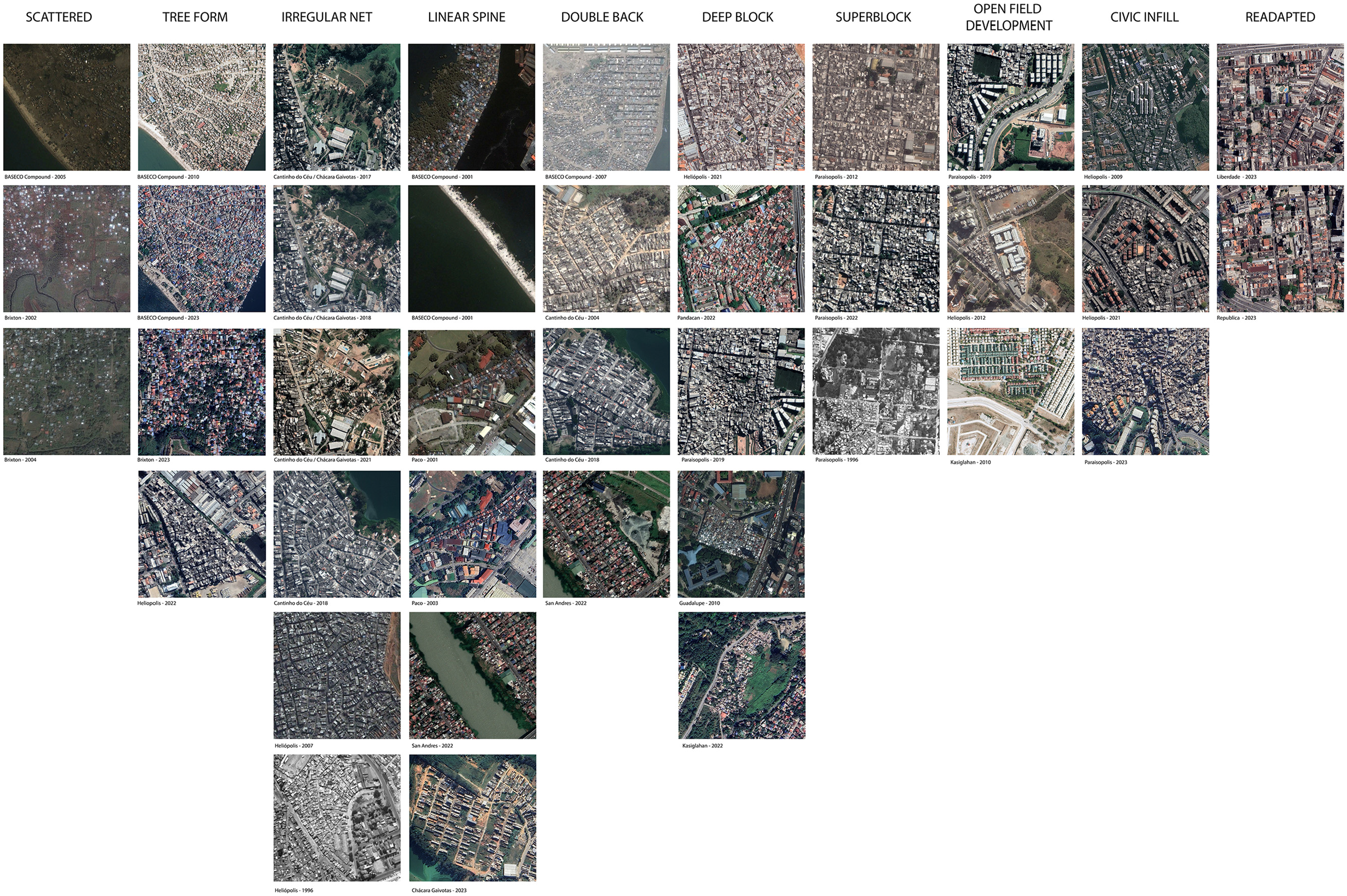
X types of informal built landscapes (400 × 400 m scale) in São Paulo, Brazil, and Manila, the Philippines.
Informal morphology analysis
With the aim of adding tools to expand the informal morphology literature, this study expands previous informal morphology methodologies to analyze informal urban forms (Dovey et al., 2023; McCartney & Krishnamurthy, 2018; McCartney, 2024). This urban form analysis builds on McCartney’s (2024) X types methodology and integrates McCartney and Krishnamurthy’s (2018) five morphological factors: non-spatial, situational, site factors, circulation space configuration, and building typology and patterns of analysis. The analysis also incorporates elements of Dovey et al.’s (2020) morphogenic properties: topography; building types (additions, construction materials); order of construction of buildings, plots, and networks; street type (car access, speed); public open space; and land coverage, adding analysis of the levels of social organization and negotiation; car access; and evolution of streets between buildings versus existing streets or paths affecting the disposition of buildings. These components are measured and analyzed by: sectional terrain analysis; observing adjacent industry and infrastructure in historical and current satellite images; circulation and connectivity—at initial occupation of land and at 10-year intervals; site visits; interviews with professionals, experts and municipal officials; historical map archives and observation of satellite images; built form mapping; circulation configuration; and block depth and building materials.
Terrain Analysis
To determine terrain characteristics (steepness or irregularities in the terrain, vulnerability, and the presence of infrastructure), Google Earth topographical information, aerial and satellite images, and literature were utilized. Perpendicular sections of informal built landscape areas were taken from Google Earth Pro (Figure 6), indicating the altitude range and average slope angle, and were used to determine the steepness, or incline, of the terrain: low (0%–5%), medium (5%–10%), and high (over 10%). The analysis also makes use of locational factors in the literature and those observable via aerial or satellite images, characteristics of vulnerability (such as flood risk, toxicity by proximity to industrial areas, and probability of mudslide), and adjacent infrastructure to the terrain.
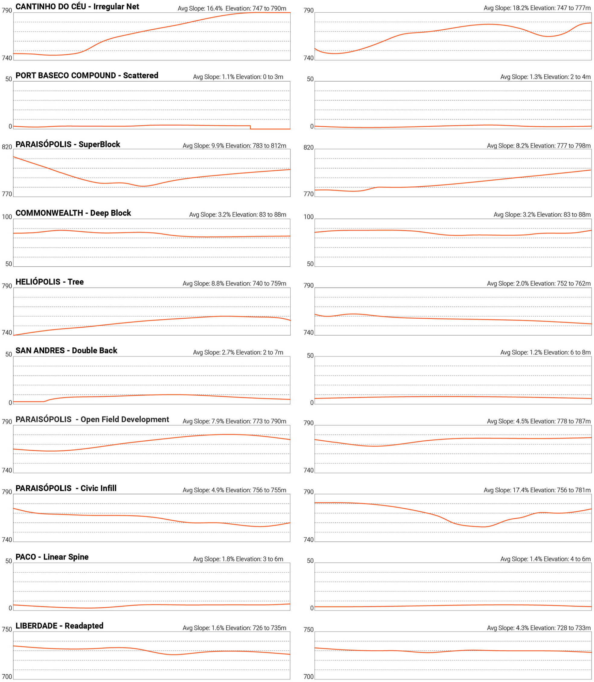
Sectional terrain analysis. Average slope percentage and altitude 300 m perpendicular to each site; altitude at 10 m increments.
Circulation and Built-Unbuilt Analysis
Even though all the data collected was digital, complemented by satellite images, the selected informal built landscapes were reproduced by hand, since this method permits a learning and analysis process that “reveals morphological patterns,” and human perception is more accurate than algorithms (Alegría & Dovey, 2022). These mapping processes, combined with terrain information from reliable municipal sources and websites (i.e., HABITA SAMPA; City of Manila and City Planning and Development Office), permitted the recognition of the influence of terrain on the resulting form and the presence of open public spaces and institutions.
In this study, the street pattern elements of each area are identified, permitting classification of the elements of the circulation configuration, as well as a settlement’s hierarchical connectivity and potential accessibility to services. These pattern elements can be present within another (i.e., a branch of the tree) and can be interpreted at various scales as the distance between nodes varies (Figure 7). The elements permit the identification of road segments and the intersection between segments or nodes (Patarasuk, 2013). The configuration of the routes and nodes defines the patterns and their internal connectivity (B. Han et al., 2020). Block depth is determined by the number of plots with access to a car-width street: shallow blocks (1–2 deep), medium blocks (3–5 deep), and deep blocks (more than 5). Street patterns, in combination with block depth, were used to determine anticipated water and sewage system connection and access to emergency services, as more connected, accessible dwellings facilitate service connection (UN-Habitat, 2012). High internal connectivity, with shallow-depth blocks, and flat terrain enable easy access to services with little to no demolition. Block depth can also determine the amount of daily negotiation required on behalf of inhabitants and emergency services to access dwellings.

Abstract street patterns, connection points, dead ends, and internal nodes of informal built landscapes.
Circulation space configuration is determined by its pattern and its road-width capacity for vehicular or pedestrian access (adapted from Dovey et al., 2020). Pedestrian circulation access between buildings is identified using street view combined with satellite images. Locations of pedestrian passageways are indicated by a visibly open space between buildings (0.60–1.5 m wide) or the presence of stairs at an access point. Some of these visibly open spaces have closed gates with a visible locking device; for the purposes of this study, such spaces are characterized as private (or semi-private) common open corridors rather than as pedestrian streets. Through analysis of previous studies, built-unbuilt mapping, and site factors, a community’s ability to use roads as open public spaces was determined by the level of formalization (informal areas) and density (high built-unbuilt density). Informal areas with high built-unbuilt density and with no access to safe public spaces typically use roads as public spaces.
Built Form Analysis
Satellite images, historical aerial images, site visits, and Google Earth street view images allow for visualization of types of materials and construction locations at different time periods (Figure 1) and enable determination of the type of building construction (Vicente et al., 2007), road characteristics (location, width, and material), the locations of lots and buildings over time, and the guiding order of construction—that is, streets first, then buildings (Dovey et al., 2020)—at the initial time of occupation.
This information determines the location of the settlement at the time of initial occupation with respect to the formal city, either as an edge or as a cluster. The location and the settlement grid pattern determine the amount of negotiation needed with neighbouring inhabitants at different times. Additionally, the number of access nodes to or from the formal city, combined with governmental policies applied to the area, indicates their level of independence from formal authorities (measured generally by a low to high scale).
At the time of occupation, potential encounters with neighbours and authorities may restrict the land options available to occupying inhabitants, as determined by the level of restrictions or tolerance from authorities (Tonucci, 2024). Less tolerant political environments tend to generate “protective” urban forms with restricted access (McCartney, 2012). The level of organization of the community at the time of occupation can be determined by the settlement's ability to create a particular built landscape (plot, block, and street layout) that adjusts to their requirements for protection or openness, which predetermines settlement growth. More organized communities predetermined their growth and maintained clear plot and street delimitations; conversely, unorganized communities have a plot-by-plot occupation with blurred limits to occupation.
Limitations
This study has important limitations in terms of the RS archives dataset and its visual and resolution level restrictions. Although Landsat imagery has been available since 1972, these low-resolution images are only able to document the presence of an urbanized settlement but not its detailed form. Detailed, high-resolution images are available through Google Earth Pro and Google Maps and its embedded images. Google Earth does not allow for the exact resolution of an image to be determined; it is estimated to be close to 30 cm. Detailed images of the settlements are constrained to more recent time periods between 2000 and 2022. Government websites, interviews with professionals who worked with community members and municipal officials, and a literature review provided data related to locating the edges of informal settlements, tenure, and relocation of settlements, but this information is fragmented due to the ingrained informality that characterizes these settlements.
The mapping of buildings and circulation networks has some limitations in terms of their precise identification, uncertainty with respect to demarcation (Kohli et al., 2012), and approximate location due to the vertical conflicts that can arise, as access routes exist under roof and upper-level overhangs of buildings and thus elude definitive identification. Images available from RS embedded images and long-term fieldwork were used to mitigate this limitation, and to understand building construction types and uses.
Morphologies of the Urban Poor
Manila and São Paulo
In Manila and São Paulo, the majority of the urban poor population settle in informal settlements. The densities of the built area of Metropolitan Manila are some of the highest in the world and almost two times that of São Paulo (Atlas of Urban Expansion, 2016). Manila is located in the north of the Philippines, on the eastern shores of Manila Bay in the South China Sea. The city contains a port within its limits and is bisected by the Pasig River, with significant land occupation along the waterfront edges. It is estimated that the population density is one of the highest in the world, with 33,135 persons/km2 (Cox, 2021). Informal settlements started to appear during the 1970s and grew considerably during the 1980s and 1990s. Initially located on vacant lands between the nucleating built area and the satellite areas of the city, some smaller settlements were located in higher-risk areas (i.e., flood-prone areas) close to high-income residential areas and major transportation hubs, industrial areas, and waterways on available land (McCartney, 2012). In the 2010s and onwards, informal settlements formed in large tracts of new hopscotch or leapfrog development in the peri-urban sector. With few exceptions, the lack of urban management institutions, coupled with the autonomy of each municipality, does not permit integrated design and execution to be put in place (UNESCO, 2016).
Metropolitan São Paulo is situated 70 km inland from the Atlantic Ocean. The urbanized area, with the exception of the northern section of the city, is characterized by rolling terrain. High-speed highways connect the city with the port city, defining the city as an inland trading nucleus. High internal national migration from rural areas led to an increasing need for housing, reflected in the growth of cortiços within the city and informal settlements in the periphery (Maziviero & Silva, 2018). After the initial occupations on the periphery were surrounded by urban development, the growth of informal settlement occurred in three sections of the metropolitan area: in northern areas, where its initial growth was in small pockets, and to the east and south west, with the settlements increasing in number and size. Most settlements in São Paulo are located outside the ring road and are not close to industry or new commercial centres, or high-income residential low lands that place increasing importance on transportation and infrastructural connections within São Paulo (McCartney, 2012).
Ten Broad Morphological Types of Informal Urbanisms
In this study, informal built landscape types from McCartney (2024) are morphologically analyzed in 10 sites in two large metropolitan cities: Manila and São Paulo. The X broad types of informal morphologies occur at three scales: neighbourhood, block, and individual building.
Figure 8a and b provides diagrams that enable analytic comparison among the X morphological types of informal settlements, while the analytical matrix presented in Table 1 expands on these X types to present a synthesis of morphological and morphogenic factors.

(a and b) X morphological types of informal settlements (2005–2022) in São Paulo, Brazil, and Manila, the Philippines.
Analysis of Informal Morphologies.

Source. Author.
Note. Based on morphological factors and patterns of analysis of McCartney & Krishnamurthy (2018), Dovey et al.’s (2020) morphogenic properties.
Building Typology: (a) developer built/(b) formally built multifamily housing/(c) self-built permanent/(d) self-built semi permanent/(e) existing formally built tenement/(f) self-built shack.
Considered at supergrid scale/nested scale.
Considering the building as an occupied vertical territory with similar characteristics to open land.
Scattered—Port BASECO 2005
Scattered in an open field types are usually located at the edges of the formal city and respond directly to topographic conditions. Initial satellite image survey of the settlement context locates Port BASECO in an industrial area disconnected from the formal city in an open field, flood-prone wetland. Analysis of satellite images from 2000 to 2024 presents a scattered configuration of the built landscape, with a building-first order of construction. Mapping of the area in 2005 portrays single houses and small clusters of houses (6–12 sq m each) with large spaces (8–60 m) between plots.
The 2005 circulation network shows that there is no clear road network present, and the road widths are undetermined as all vacant land is accessible for circulation by vehicles and pedestrians, and block and building frontage are not present. There is a loose and haphazard street layout that does not anticipate—at this point—water and sewage system connection. Due to its configuration, the block depth is mostly shallow, suggesting limited daily negotiation to access the dwellings. Additionally, the single dispersed and disconnected buildings indicate reduced need for negotiation with the community at the time of occupation. The level of reflectance identified in the 2005 satellite images reveals low-quality structures. Surveyed over time, the irregular vacant areas in Port BASECO gradually infill building by building, resulting in an Irregular Net morphology, with different characteristics, such as higher levels of daily negotiation and organization, from those that existed in 2005. Additionally, the low reflectance and regular shapes of the materials in the 2024 satellite images indicated better-quality materials and construction.
Tree Form—Heliópolis 2005
Tree Form is a low-level connection network that, while appearing chaotic to the outsider, is in fact made up of a complex hierarchy of streets and pathways (Habraken, 1998). Contextual satellite images reveal that Heliópolis is located within a cluster of the São Paulo formal city. The built-unbuilt mapping of the circulation network shows a dense composition, with three nodes of access.
In the Heliópolis Tree Form, the circulation configuration indicates three or more hierarchies of access streets, with a linear arterial main street (B. Han et al., 2020), wide enough for car access (varying between 3 and 10 m wide), that branches out into multi-directional car-width (varying between 2 and 5 m wide) and pedestrian streets, with several additional smaller pedestrian dead-end roads that connect to the dwellings. Sections of the area show that the terrain presents a steep slope perpendicular to the main road, and a main street section with a low-slope terrain that may be easier to connect with the settlement, forming a tree street pattern. This road branches out into smaller, steep pedestrian roads in order to facilitate access to harder-to-reach terrain. Researchers have linked single or restricted car-width access to high levels of control within a settlement, creating a defensive form against eviction for its inhabitants. As presented by Cuenya et al. (1990), this configuration strategy suggests high levels of negotiation between inhabitants as a result of controlling car road access to the neighbourhood.
Satellite images and historical aerial images (1954–2024) reveal that Heliópolis’Tree Form results from co-evolving buildings and streets. Street view images show that the main street and branches are used as public space for its inhabitants, and its compact configuration is dominated by self-built permanent or semi-permanent buildings. Built-unbuilt mapping shows varied block depth (three or more dwellings deep), indicated a medium level of negotiation required to perform everyday activities.
Irregular Net—Cantinho do Céu 2008
From contextual satellite images, it can be determined that Cantinho do Céu’s Irregular Net built landscape is located at the edge of the formal city. Cantinho’s Irregular Net has been established in an environmentally fragile area that is prone to flooding (Cavalcanti & Alvim, 2020), and responds to the high-angled slope observed in the sections of the study area and contours of the terrain by creating a non-orthogonal pattern.
The circulation configuration grid pattern (6–10 m wide) reveals multiple accesses and a high-connectivity car-width scale with little to no dead-end roads. This may indicate little administrative or political willingness to evict (Hylton & Charles, 2018) where existing access routes can facilitate the building and provision of urban infrastructure services. The built-unbuilt mapping indicates no daily negotiation is necessary for access to car-width streets for fronting structures, but some negotiation is needed for deeper block buildings (5–10 deep) with pedestrian access.
This area is characterized by an illegal subdivision (loteamentos irregulares) strategy of occupation with some security of tenure (Cavalcanti & Alvim, 2020), denoting a settlement layout with some (medium) level of organization. Satellite and historical images (1954–2024) indicate a co-evolution of buildings and streets, resulting in an irregular shape. The evolution of the block composition, with a frontage-first configuration, leaves a large open space at the centre of the block, providing temporary open public spaces, which are later filled in with other buildings located behind. Similar to other deeper block configurations, levels of reflectance indicate that frontage structure materials are mostly permanent, with more transient construction evident in the centre of the block. Due to the high level of negotiation and medium level of organization of inhabitants at the time of occupation, car-width streets endure as public open space.
Linear Spine—Paco 2010
Linear Spine built landscape types are clear responses to available yet constrained site conditions (McCartney, 2024). Contextual satellite images and sections indicate that Paco settlement is located on a flat site adjacent to industrial buildings, where the linear element forms the main access route and operates as a central public space. This location and the lack of administrative will to provide infrastructure services (Kwak, 2015) often prevents infrastructure provision despite adjacency to the formal city. In this Linear Spine built landscape, the level of reflectance in satellite images shows that the dwellings and structures are self-built semi-permanent buildings or shacks and follow the linear element of the railway corridor, conglomerating densely in various plot depths. The built-unbuilt mapping indicates blocks five to 10 deep, with deeper block configurations necessitating daily negotiation with frontage inhabitants to access the street or the linear element. The Paco settlement visible in satellite images organizes space along a linear street, which may indicate that low levels of organization are required at the time of occupation. Additionally, this dense configuration prevents the formation of open public spaces; public uses are circumscribed to the singular access road or linear element.
Double Back—San Andres 2010
The Double Back built landscape of San Andres consists of a double-building-depth layout, where every building or plot has direct access and frontage to a car-width access route (3–4 m wide). The built-unbuilt mapping of this structure reveals orthogonal development on a regular grid that is not significantly responsive to terrain and contours. San Andres is located by the Manggahan Floodway at the edge of the formal city, as shown in the contextual satellite images. The multi-access net configuration of the Double Back built landscape resembles a formal city development, suggesting little political or administrative willingness to evict. Images of the area from 2002 to 2024 indicate a street-first layout with a predetermined lot assortment. This configuration requires a high level of organization at the time of occupation to secure an orthogonal block orientation, constant block depth, and car-width access routes.
San Andres’Double Back morphology, viewed in street images, satellite images, and photographs, consists of permanent or semi-permanent self-built structures or developer-built multi-family housing. Location on a car-width public street provides inhabitants with negotiation-free access to everyday activities and public open space, while also permitting the easy facilitation of future infrastructure services.
Deep Block—Commonwealth 2010
The Deep Block type is a grid or net block configuration determined by the terrain and size of the grid, with varying block depths that consist of three or more plots that are densely placed and fill the block structure (McCartney, 2024). Contextual images show Commonwealth Deep Block located in a cluster of the formal city. The circulation configuration indicates large blocks with car-width streets (5–7 m) with individual pedestrian access alleys extending from the frontage through to the plots located at the centre of the block. With multiple nodes connecting the large block to formal adjacent settlements, this area is moderately connected.
Construction of most of the initial grid layout was led by the government, completing the car-width road frontage and later densifying inwardly towards the centre of the block (5–15 buildings deep) (Cabalfin, 2014). Built-unbuilt mapping indicates that small irregular courtyards of public space are formed within the block used for resident access to the deeper dwellings within the block. Satellite images from 2024 show that these vacant plots will be used as public space and infilled later, indicating a medium level of organization at the time of occupation. This inward densification may be a “defensive” strategy responding to administrative or political willingness to evict. Street view and satellite images of building reflectance show self-built permanent building types located along the frontage of the car access road and becoming more impermanent (semi-permanent and shack) towards the centre of the block.
Satellite and street view images show some institutions (i.e., churches) in the study area but few open public spaces in the blocks, with the available open space of inhabitants comprising the access road as well as vacant spaces within the urban block. Built-unbuilt mapping indicates that access for deeper plots and construction may be negotiated with successive frontal neighbours as the block deepens, and the further within the block one resides, the greater the number of neighbours with which one must negotiate in order to secure construction and right of way.
Superblock—Paraisópolis 2008
The Superblock type is composed of very large blocks, conveying two scales on the site, comprising a supergrid—resembling an Irregular Net or Deep Block type but much larger in size—that is nested with other forms in each block (McCartney, 2024). At the time of occupation, Paraisópolis, as shown in a historical image from 1954, is located at the edges of the formal city in an unoccupied, medium slope area that is large enough for very large blocks to develop. The circulation configuration shows supergrid-wide roads (4–7 m) of a consistent width and hierarchy, permitting car access and composing a multi-access net morphological configuration. Built-unbuilt mapping indicates that Paraisópolis has nested within it a Tree Form built landscape, characterized by clustered structures within an interior configuration of hierarchical dead-end car roads (2.5–3.5 m) or pedestrian pathways that branch into short dead-end roads.
Images from 1954 to 2024 reveal the settlement was established through an evolution of car-width streets at the supergrid scale from a rural lot division predating the later occupation (Maziviero & Silva, 2018). Initially, buildings primarily occupy the supergrid frontage, and later, within the block, buildings co-evolve to establish an internal street configuration. Street view images and satellite reflectance show self-built permanent structures in the frontage and semi-permanent buildings and shacks along main internal roads. Communities that inhabit the Superblock type have different levels of organization at each scale; historical images depict what appears to be a high level of organization at the time of first occupation in order to determine or secure the car-width supergrid configurations, and a medium level of organization when securing the main access points to the interior of the superblocks and further occupation within the block.
Similarly, the built-unbuilt mapping portrays a dense block configuration, with blocks 20 plots deep. This configuration implies a low level of negotiation in everyday life with those that control both the frontage buildings and access of the supergrid and a medium level with those that control the internal plots. Service provision is easily accessible along the main supergrid access roads, but within the block, the dense building configuration limits the possibility of connection to urban infrastructure services. Lot configuration and density also inhibits the formation of open public spaces, leaving inhabitants of Superblocks to use the main supergrid and internal roads and vacant areas or lots as open public space.
Open Field Development—Paraisópolis 2020
The Open Field Development type refers to multi-storey buildings containing multiple attached housing units constructed in an open field, at the edge of the formal city, commonly appearing in groups at the margins of a nearby informal settlement (McCartney, 2024).
The Paraisópolis Open Field Development contains a group of tall, multiple-storey developer-built multi-family housing built in association with a government agency (Maziviero & Silva, 2018), located in flattened, vacated, and low-land-cost areas next to a freeway. Although its structures are purposely connected with the infrastructure services of the formal city, due to Paraisópolis’ remote location, transportation and services provided by public institutions may be difficult to reach.
Built-unbuilt mapping and street view images show that Paraisópolis’ buildings are surrounded by areas that were designed for parking and open green spaces, constituting large open public spaces. Although located adjacent to the informal settlement, these buildings are disconnected from the settlement’s pedestrian circulation and access (i.e., by a tall fence), with block circulation limited to car access by a single looping street. Highly organized administrative and public resources are available for the construction of this type, particularly due to the need for demolition, as shown in satellite images from 2008 to 2016; but due to physical disconnection from the informal settlement, this type involves little negotiation with settlement residents at the time of construction and for everyday activities.
Civic Infill—Paraisópolis 2020
Civic Infill types comprise multi-storey buildings of various uses, typically developer-built or, as in the Paraisópolis case, government-funded medium or large structures, situated within or at the margin of an informal settlement and connected to the circulation configuration of the informal settlement. Originating from a political, administration-led participatory process with its inhabitants, Paraisópolis’ configuration aimed to become a “neighbourhood” (Maziviero & Silva, 2018). Additionally, this project provides mixed uses, services, and open public space to the area.
As shown in 2016 satellite images, part of this process includes demolition and relocation of the mixed—use buildings of some residents of the informal settlement (Maziviero & Silva, 2018); thus, high levels of negotiation and organization were needed. The circulation configuration indicates that the Civic Infill type is connected with the informal urban network and is built at the neighbourhood’s juncture with the formal city to facilitate connection to a transportation route and infrastructure services. The built-unbuilt mapping indicates that this construction creates a frontage or an edge, thus limiting the expansion of the informal settlement. Due to the formal separation between public and private spaces and the car-width street frontage access of the development, little everyday negotiation is needed.
Readapted—Liberdade 2020
Readapted types (also called cortiços in São Paulo) are usually located in well-connected formal urban areas, as they are abandoned structures later occupied and modified as informal settlements (Stevens & de Meulder, 2018). In Liberdade, they present as individual lots located within the formal city, where residents benefit from proximity to urban and infrastructure services as well as public spaces. However, these formal services do not usually exist within the lot or building.
Readapted types emulate the Tree Form’s distribution of plots due to a vertical or horizontal high hierarchical access “road”—for example, stairs, small pedestrian road, or elevator—and a distribution floor by floor of densely organized dwellings around smaller “branches,” such as hallways. Similar to Tree Form types, the same protection of entry from security forces, strategies of control, and negotiation of space are present. In Liberdade, the Readapted type varies according to its previous use: either formal housing, where the building is modified very little; or commercial or industrial, where modifications are required as dwellings are constructed within the building or plot and are self-built semi-permanent or shack building types.
With low levels of organization at initial occupation, location of initial dwellings typically prioritizes access to light, rather than having “frontage” on a main internal network “road.” High negotiation levels are needed at the time of occupation due to the preference for light by all inhabitants, which can be easily blocked by others. Everyday activities require low negotiation levels between inhabitants due to the shallow depths of the “blocks” established by the small floor plate size.
Discussion: Urban Form and Informality
Recent literature has contributed to a better understanding of informal settlements, particularly with respect to identifying their locations and development patterns (Dovey and Kamalipour, 2018; Dovey & King, 2011; Y. Han et al., 2017; Samper et al., 2020; Thinh et al., 2024). This has contributed to the creation of more effective strategies for addressing these settlements (Samper et al., 2020). However, researchers have emphasized the necessity of more rigorous analytical frameworks to supplement the increasing information flow from these informal areas (Chakraborty et al., 2015). This study addresses this gap by applying typologies of informal built landscapes developed by McCartney (2012, 2024) to create a methodology for analyzing informal urban morphologies that can be applied to these areas globally. This typo-morphological analysis highlights the differences among informal settlements in terms of service delivery, location within the city structure, terrain, public space, access to plots, building typology, organization, and the level of negotiation required by a community and its members, with a comparison of 10 types of informal morphologies recorded in Table 1. Additionally, this study aims to add to the literature by examining the implicit rules that shape particular forms and arrangements of buildings, lots, and streets within these types.
Analysis of informal settlement location, organizational characteristics, and tenure security indicates their particular influence on a settlement’s urban morphology and its potential access to services. A settlement’s internal organization can manifest in large, dense assemblages of structures and people, creating “protective forms” to guard against forceful evictions (Cuenya et al., 1990; Dekel, 2020). These morphologies are characterized by deeper block arrangements (Tree Form, Super Block, and Deep Block) and/or low connectivity (Scattered), which hinder potential access to services (McCartney, 2024). In contrast, morphologies that resemble the formal urban fabric (Double Back and Irregular Net), with high organization at the time of occupation due to pirating or illegal development, enable de facto security of tenure, making inhabitants feel safer from evictions (Doebele, 1977). These urban structures create circulation configurations with high connectivity, facilitating access to services.
Additionally, government formal action or inaction (Roy, 2005; Tonucci, 2024), and the social and self-organization of settlements (McCartney & Krishnamurthy, 2018; Sotomayor, 2015), contribute to the creation of particular informal urban forms that are interrelated with the formal city. Planned government interventions include relocation and resettlement strategies, as well as upgrading strategies, with the latter being linked by international organizations to “development opportunities, poverty reduction, optimization of land use and generation of wealth” (UN-Habitat, 2012, p. 17). In this study, two morphological types are identified as created by these interventions: Civic Infill and Open Field Development. These configurations indicate a willingness to create a permanent and open area that integrates the informal street layout with the formal city (UN-Habitat, 2012). Although these types have high levels of organization with the community at the time of construction, their respective morphologies have differences in terms of occupant behavior through negotiations required at the time of occupation, access connections desired with respect to the settlement circulation configuration, the daily organization of everyday life, and the availability of public space. Civic Infill allows a connection between the informal settlement and the circulation infrastructure via the opening of main streets or key alleys, which expands building opportunities for accommodating commercial functions (Thinh et al., 2024). This configuration involves negotiations that consider the specific needs of the community, usually resulting in small public spaces separated from the streets, organizing the public space (UN-Habitat, 2012). This organization and negotiation with the residents in the production of public space discourages appropriation by residents, which is otherwise common in informal urbanisms (Van Oostrum, 2022). In contrast, Open Field Development is situated in an open, unoccupied (or demolished) site requiring little to no negotiation with existing community members at the time of occupation. Following modernist principles, its street layout and self-contained building structures facilitate a clear, efficient connection with the formal city’s infrastructure, but it remains deliberately segregated from the adjacent settlement street layout.
Considering these types over time enables this study to contribute to a broader understanding of how each configuration has been “modified” by government action (Civic Infill) or has “evolved” as a result of its absence (Readapted, Tree Form). Settlements with low organization are typically characterized by lot-by-lot increments that begin with low-quality, non-permanent materials; as they secure their position, these structures evolve to incorporate better-quality materials (Dekel, 2020; Dovey et al., 2020; McCartney, 2012, 2024). Additionally, these initial structures maintain, or secure, a fronting position on the access streets (as seen in the Port BASECO evolution from Scattered to Irregular Net). When organized at the initial time of occupation, structures are typically constructed with better, more permanent materials and techniques (Double Back, Cantinho Irregular Net), securing their position longer and enabling more investment in their building construction (Payne, 2004). Public spaces in Open Field Development types are often later occupied by the growth of the neighbouring settlement, evolving into Civic Infill types. In response, governments and designers create strategies (fences, sport fields) to preserve these spaces (Collado & Potangaroa, 2020).
Various types can be part of a single neighbourhood or nested within each other, with Super Block typically nesting with other types such as Tree Form types, thereby creating high connectivity in the main streets and “defensive” encroachment processes described by Dekel (2020) manifested within the superblock. This approach permits researchers to identify distinct typologies within the same settlement and the connections among them. An example presented in this study is Paraisópolis, where different urban configurations (Super Block, Open Field Development, and Civic Infill) coexist as each configuration has experienced its own evolution and interaction with government programs and tenure security.
Even though approaches to urban management are particular to the two geo-cultural regions studied here, the commonalities of form permit a general discussion on strategies of settlement and the relative success or failure of government programs. The current paper’s focus on an analysis of urban forms is not intended to obscure the challenges of the urban poor, but rather to add to discussions of morphological and urban form challenges such as densification, growth, and connectivity, and the potential of inhabitants to access urban infrastructure, jobs, and security of tenure. This study does not reduce these settlements to their urban forms but adds to the literature on informal settlements to aid in the building of informal urban policies and to provide new perspectives on a path forward in the living conditions of their residents.
Policy Implications
Expanding the Language of Urban Policy to Include Morphological Types of Informal Urbanism
Researchers, governments, and NGOs agree on the benefits of mapping and the development of positive policies that address the particular needs and challenges of each settlement (UN-Habitat, 2012). Organizations wanting to better the lives of the urban poor would benefit from a recognition that the urban fabric of each community is heterogeneous, rather than defined only by its economic status, and analyzed according to its urban morphological type—a type that will likely evolve into other types (i.e, BASECO’s evolution from Scattered to Irregular Net) after settlement growth or formalization policies are put in place.
These morphological descriptions should be normalized in policy to discuss the urban form of a neighbourhood. Analyzing informal urban built landscape types links the discussion to other aspects of specific urban settlements that have previously been studied. This research will inform policy-makers, enabling them to systematically recognize and analyze accurately the forms of urban fabric in communities of the urban poor in their cities, as well as to address specific attributes of each of the types, and to formulate and implement planning and building strategies to better integrate settlement types with the infrastructure of the broader city.
How Urban Forms can be in the Way of Urban Integration With the City
Varying levels of social and self-organization of informal settlements respond to city dynamics in anticipation of formalization. Responses by the community include protectionism through urban form (i.e., Tree Form, Deep Block) or emulating formal codes and access standards (i.e., Irregular Net, Double Back) in anticipation of a potential formalization by the city administration and connection to urban services, such as power, water, public transportation, and public institutions. Block configurations like Irregular Net and building configurations such as Double Back are already prepared to be connected to services, while other configurations, like Tree Form, Scattered, and Linear Spine, may need adaptations to their block configurations to enable a connection. A common strategy to address this is to modify the pattern to emulate Irregular Net forms and to connect with existing transportation networks of the city. This underscores the importance of urban policies—that is, upgrading, tenure transfer, constructing incremental housing—that harness informal urbanisms of the urban poor as a positive strategy in city expansion. When there is no administrative or political will to evict or resettle, inhabitants feel secure and in the construction of their communities emulate open access morphologies of the formal city.
Certain types can affect potential access to open public spaces, while many would most likely use streets as a public space. Highly organized types such as Double Back, Irregular Net, Open Field Development, Civic Infill, and Superblocks usually contain within them regularized open spaces that will not be occupied by dwellings and will remain uninhabited for open space use or future social infrastructure development. Double Back and Irregular Net patterns usually contain more car-width accessible circulation spaces that are more conducive to their use as a combined public space than other types. Compact and often loosely organized types such as Tree Form and Linear Spine commonly lack controlled open public spaces. Here, the spaces allocated for public use can be scattered within the block or combined with pedestrian and car roads. Scattered types usually contain loose and dispersed public spaces in the vacant lots, but the unorganized nature of this type limits the endurance of such places.
Block depth is a major factor that can slow down access to services for the urban poor, as the physical structure of informal areas has been reported as a challenge with respect to service connections (UN-Habitat, 2012). Modification of internal pathways in order to enable easier access—that is, paved pedestrian roads and stairs—can provide the space for safer service connection and aid access to health and security services. A strategy to address at-risk tenants is to relocate inhabitants to Civic Infill types within the informal urban net. This strategy, also used for displaced tenants in grid pattern modifications, can help set boundaries to growth, provide public spaces, redefine the edges, and connect to urban services. When considering modifications to all neighbourhoods, site factors and risk particularities have to be examined for each type to address structural integrity, health, and other risk factors that can jeopardize human life. In these cases, public officials alongside the neighbours need to understand the limitations of the urban types within the neighbourhood. Moreover, the role of the state and other institutions as well as individuals in settlement growth and evolution should not be understated (Tonucci, 2024), as they are entangled in the production of these settlements and in the prevention of planning action to solve their issues.
Conclusions
This research analyzes informal urban typo-morphologies in order to recognize their commonalities and particularities and to inform research and policy analysis and practice. Through an analysis of 10 São Paulo and Manila case studies, this study provides a comparison of morphological patterns, advancing the emerging body of literature on informal settlements and establishing the foundation for further analysis of urban patterns and their varied configurations, organization, combinations, transitions, and community negotiations. This study moves the discussion away from the dichotomous concepts of formality and informality, planned and unplanned, by recognizing informal urban morphologies that have formal and informal planning intertwined in the urbanization process. The present study also furthers our understanding of informal settlement analysis methodologies, informing designers and planners encouraging them to harness the capacities and strengths of these living environments, while also highlighting that there are many dimensions of the examples of informal urbanisms contained herein that remain unexplored. This paper also aims to provide a means to enable further discourse and investigation to create more just cities for the many urban settlers arriving in cities globally.
Footnotes
Acknowledgements
I thank my doctoral dissertation advisor Dr. Joan Busquets, and committee members Dr. Hashim Sarkis and Dr. Mona Serageldin for their commitment to my work and growth as a scholar—and being examples of the type of professor that I would like to be. I gratefully acknowledge research assistance by Victoria Bell, Donna Bridgeman and Lily Huang, and especially for research assistance from Ximena Rosenvasser for deep discussions that pull this work forward. I also thank the four anonymous reviewers and article editor who helped me to improve the manuscript with excellent comments and suggestions.
Ethical Considerations
There was no animals or humans subjects used in this study. This research project was determined to not require ethics review or approval by Toronto Metropolitan University. Interviews occurred with individuals who are not themselves the focus of the research, but who are authorized in the course of their employment/expertise to provide information regarding policies, procedures and professional practices of the organization or community. Such individuals are not considered participants for the purposes of the TCPS2.
Funding
The author(s) disclosed receipt of the following financial support for the research, authorship, and/or publication of this article: This work was supported by the Harvard University Doctoral Fellowship Scholarship, Harvard University David Rockerfeller Center for Latin American Studies Travel Research Grants, Weatherhead Center for International Affairs at Harvard University Canada Research Fellowship, Joint Center for Housing Studies John R. Meyer Dissertation Fellowship Scholarship and IFMA Foundation Scholarship.
Declaration of Conflicting Interests
The author(s) declared no potential conflicts of interest with respect to the research, authorship, and/or publication of this article.
Data Availability Statement
Data sharing not applicable to this article as no datasets were generated or analyzed during the current study.