
Abstract
The goal of this study is to evaluate the use of the Geographic Information System (GIS) in tourism research. While there is a lot of research on the various aspects of GIS in tourism, there is currently a lack of a comprehensive overview of the existing studies. This study aims to address this gap by conducting a bibliometric analysis of 434 articles on GIS-based tourism and sustainability research papers that were published between 1996 and 2023 in the Web of Science (WoS) database. The research investigates 434 articles gathered as of January 11, 2024. Bibliometric analysis is conducted using the VOS viewer program. Multiple techniques are applied, including bibliographic coupling of countries and journals, co-authorship analysis among countries, co-citation analysis of journals, and examination of author keywords and abstract term co-occurrences. Moreover, longitudinal trends in publications and citations pertaining to GIS-based tourism and sustainability articles are analyzed in the study. The use of advanced GIS techniques is essential for making informed decisions in sustainable tourism management by better comprehending the factors that influence visitor demand.
Keywords
Introduction
Geographic Information Systems (GIS) is a computer-based instrument for mapping and analyzing data (Esen et al., 2008). Early in the 1990s, GIS began to be used in the planning and management of tourism (Yianna & Poulicos, 2011). According to Goodchild (2010), GIS is one of the technologically created systems with advanced information interpretation and data display during the previous 20 years. GIS can be applied to manage the extensive and varied data required for the tourism industry, predict indicators, and mainly support decision-making during the planning, monitoring, and assessment phases (Goodchild, 2010). Furthermore, the use of GIS technologies can significantly improve sustainable tourism development.
Sustainable tourism development has become a priority for destinations facing the adverse impacts of mass tourism. Authors such as Amerta et al. (2018) emphasize the need for sustainable tourism development to align with the regenerative capacity of resources. The accuracy and reliability of information about managed resources are crucial for making quality decisions in sustainable tourism (Amerta et al., 2018). Additionally, collaboration among stakeholders is deemed essential for promoting sustainable tourism (Vuković, 2022). To this end, GIS and spatial decision-making technologies have been proposed as critical components for supporting sustainable tourism (Jokar et al., 2021). In other words, GIS can be considered an appropriate framework for land suitability and decision-making for future tourism planning strategies if sustainable tourism is to be organized (Malczewski & Rinner, 2015).
The capabilities of GIS in the tourism sector have been widely discussed in the literature. Authors such as Bahaire and Elliott-White (1999), Farsari et al. (2004), and Waleghwa and Heldt (2022) have highlighted GIS applications in tourism, including inventorying tourism resources, identifying prime development sites, and assessing the impact of tourism on natural resources. Furthermore, Cvetkovic and Jovanovic (2016) have emphasized the use of GIS for regional master planning in sustainable tourism, demonstrating its global relevance in preparing regions for growth and development.
Given the various strategies for GIS usage, it is evident that GIS plays a vital role in developing sustainable tourism. The study, planning, and monitoring of indicators and conflicts using GIS have been identified as crucial for determining optimal locations for tourism industry development (Kyriakou et al., 2017). However, despite the extensive reflection on GIS applications in the tourism industry, there is a lack of an in-depth overview of the studies conducted in this area. Thus, this study attempts to fill this gap by carrying out a bibliometric analysis of the research available in the Web of Science (WoS) database, focusing on GIS-based tourism and sustainability. Collectively, the publications in this analysis span from 1996 to 2023. This selection of articles allows for an understanding of the current state of GIS-based tourism and sustainability research in the WoS and an insight into the historical development of this research area.
Literature Review
Geographic Information Systems (GIS) play a pivotal role in the tourism and sustainability domain, offering diverse analytical capabilities and serving as a valuable management and research tool (Bernhardsen, 2002; Serneels & Lambin, 2001; Wu et al., 2006). This literature review aims to explore the multifaceted applications of GIS in tourism and sustainability, encompassing its analytical, managerial, and research-oriented functions.
Analytical Capabilities of GIS
The literature reveals the diverse analytical capabilities of GIS in the context of tourism and sustainability. For instance, Chen (2007) highlights the applications of GIS in retail tourism and teaching curriculum, shedding light on visitor patterns and land suitability analysis. Similarly, Albuquerque et al. (2018) emphasize using GIS tools for tourism marketing, including environmental management and tourism development modeling based on scenario analysis. However, the literature indicates a significant gap in the empirical application of GIS for analyzing visitor patterns and resource allocation in tourism contexts. Chen (2007) emphasizes that most GIS applications in tourism focus on identifying suitable areas for future tourism development, neglecting the analysis of already established destinations. Vuković (2022) highlights that while GIS has been applied in various case studies, there is a lack of focus on how it can be utilized to analyze and manage tourism in areas that have already developed significant tourist infrastructure. Vuković (2022) also underlines a need for further exploration into how GIS can be effectively utilized to enhance decision-making processes in mature tourist locations, where visitor flow and resource management are critical for sustainability (Humsona, 2023).
According to Thapa et al. (2017), the scientific analyses conducted for tourism planning with the help of GIS are essential and need to be enhanced. They saw the value in GIS for data capture and tourism impact assessments but made a case for a more sophisticated use of this technology. This viewpoint is consistent with Simou (2024), who also found the potential in GIS to analyze and assess tourism planning for the space and infrastructure needed to host visitors. Both studies share an impulse to call tourism research to account for a missed opportunity to use GIS more creatively and meaningfully. Moreover, Lawelai (2024) notes that integrating GIS with big data analytics can fine-tune tourism development strategies. Still, few studies have applied these powerful tools to the context of tourism. Generally, the gap in knowledge surrounding the analytical capabilities of GIS means that more research is needed, especially in: (a) established tourism destination case studies, (b) the integration of huge datasets of various types (spatial and aspatial), (c) sophisticated analysis of those datasets to produce useful knowledge, and (d) visitor flow analysis to inform where GIS should sit within comprehensive decision support systems. Making good on these shortfalls will create more efficient and enduring tourist trilogies, giving GIS in the tourism sector a better chance to enhance its role within that sector.
GIS for Spatial Modeling and Analysis in Sustainable Tourism
GIS should be employed to facilitate efficient spatial modeling and analysis to achieve sustainable tourism objectives, since it is recognized as the most effective technology for developing tourism management strategies (Longley et al., 2015; Omarzadeh et al., 2022). Although many destination management organizations presently utilize GIS primarily for mapping tourist movements and routes during their visits (Ali & Frew, 2014), leveraging GIS to create a model for sustainable management could offer benefits in preserving tourism resources and fostering loyalty, ultimately contributing to long-term financial viability and sustainability. Even though GIS is acknowledged as a potent tool for spatial modeling and analysis, its use in the application of sustainable management strategies for tourism has yet to be explored. The authors Longley et al. (2015) and Omarzadeh et al. (2022) advocate for its application in the creation of sustainable tourism models. Still, many tourism management organizations appear to use GIS only for the rudimentary mapping of tourists. Simou (2024) also discusses the potential of GIS for assessing visitor flow patterns and infrastructure requirements. Yet, there is a need for more sophisticated analytical methods that can provide deeper insights into tourism dynamics. Research should focus on developing and applying advanced GIS techniques, such as spatial modeling and predictive analytics, to improve tourism management practices that could provide new insights into optimizing the allocation of both human and physical resources for the sustainable functioning of tourism.
GIS as a Management Tool for Sustainable Tourism
The use of GIS as a sustainable tourism management tool is not very thoroughly researched, particularly when it comes to leveraging GIS for multistakeholder collaboration and consensus building. Vuković (2022) underscores the vital role of GIS in sustainable tourism. Yet, scant attention has been paid to how the system engages an often-diverse planning stakeholder group. Furthermore, when McGehee (2014) and Aminu et al. (2017 describe the application of GIS in sustainable tourism contexts (such as community asset mapping and even trail planning), their conversations invariably lack the key ingredient of stakeholder engagement. The Theory of Geospatial Analysis provides a fundamental understanding of the use of geographical information systems for spatial data, including the location of biodiversity hot spots, which organized tour operators and their customers may find useful. Nizamani et al. (2023) contend that it is important to carry out research not only on how GIS can help with the sustainable development of this specific form of tourism but also on how practical applications of GIS can be used in real-world decisions within the tourism sector under the guise of boosting the sector’s resilience in the face of environmental, health, or economic shocks.
Aminu et al. (2017) discuss a framework for sustainable tourism planning in Malaysia, emphasizing GIS applications in sustainable tourism infrastructure planning, visitor segmentation, zoning, and transportation network planning.
Bahaire and Elliott-White (1999) were the first scholars to highlight the importance of GIS in analyzing sustainable tourism factors, assessing site appropriateness for planned growth, and identifying opposing viewpoints. Aminu et al. (2017) suggested integrating the application of GIS, ANP, and the Water Quality Index (WQI) for planning sustainable tourism. Sustainable tourism infrastructure planning (STIP) focuses on tourism planning as an integrated approach based on sustainability criteria. Using GIS, STIP seeks to incorporate several sustainability parameters into infrastructure planning, including development goals, visitor experience preferences, carrying capacity standards, and resource impacts (Boers & Cottrell, 2007). Sustainable Development Theory highlights the essential need to harmonize three constituents in the often-acronymized triple bottom line of economic growth, environmental protection, and social equity. These three constituents, often referred to in tourism development discussions, theoretically constitute a triad of essential components for achieving sustainable tourism destination development and management. This theory aligns with what Vuković (2022) noted about GIS applications and their use in sustainable tourism management. Xu et al. (2020) elaborates on mechanisms for making decisions in tourism but does not present well-formed ideas about how to use GIS to leverage these decisions for optimal outcomes in the tourism sector. Chen (2007) talks about the application of GIS to tourism and notes that few researchers have applied GIS to tourism planning and management practices, indicating a gap in the literature regarding the practical impacts of GIS on tourism sustainability. Integrating these theories (Sustainable Development Theory and Geospatial Analysis Theory), a solid theoretical foundation for the research on the use of GIS in sustainable tourism can be laid down. These frameworks emphasize the importance of spatial analysis and a balanced approach to tourism development, which considers economic, environmental, and social factors.
GIS as a Research Tool for Sustainable Tourism
The literature review also highlights the significance of GIS as a research tool in tourism and sustainability. Malczewski and Rinner (2015) provide an overview of GIS-MCDA applications, emphasizing the limited research on uncertainty associated with selecting the best GIS-MCDA methods. Vuković (2022) emphasizes the importance of utilizing GIS for master planning in sustainable tourism, while Thapa et al. (2017) emphasize the role of GIS in spatial data collection and processing for sustainable tourism initiatives and government decision-making. Ghorbanzadeh et al. (2019) used GIS to distinguish between places with no tourism value and the most popular tourist destinations, which could be utilized to identify sustainable tourism destinations further and classify them according to their level of sustainability. Even in studies like those by Thapa et al. (2017) and Ghorbanzadeh et al. (2019), where the researchers sought to highlight the power of GIS in relation to spatial data collection and processing, the actual demonstration of GIS’s effectiveness for this relatively new evaluative context is still lacking. Aminu et al. (2017) identified locations for sustainable tourist development, most less susceptible to human influence and only made up 0.57% of the areas. Additionally, they have identified limitation areas and regions that would be protected from tourism in connection with sustainable development. While Ghoochani et al. (2020) emphasize the need for consensus among stakeholders for sustainable tourism management, the specific contributions of GIS in measuring and monitoring tourism impacts on fragile environments are not sufficiently documented. The global importance of GIS in master regional planning for sustainable tourism cannot be overstated. An increasing interest in GIS-based research on tourism and sustainability can be seen from the analysis of the relevant publications. However, the authors of this bibliometric study urge caution. Even though interest is growing, significant gaps remain in the application of GIS tools and techniques to study the problems and arrangements of tourism, particularly in research contexts where tourism is a well-established and dominant activity (Fuchs, 2023). Additionally, the perspectives of local communities regarding tourism’s economic and social impacts are often overlooked in GIS applications. Research is needed to explore how GIS can enhance communication and collaboration among stakeholders, particularly in addressing local community concerns related to environmental sustainability and tourism development.
GIS for Environmental Protection and Local Community Perspectives
In addition to environmental protection, sustainable tourism also considers the perspectives of the local communities about tourism’s economic and social impacts (Janusz & Bajdor, 2013). As a result, GIS can be utilized to enhance the handling of waste, energy tracking, decision-making, data exchange, and collaboration (Ali & Frew, 2014). Enabling conveniently accessible and concise information could aid in this complex decision-making process to address significant concerns for sustainable tourism. Destination managers can concentrate on practicing sustainable tourism management once they can access this information. By creating platforms where all stakeholders may exchange information on issues related to sustainable tourism, this technology will improve communication between travelers and tourism organizations (Ali & Frew, 2014).
The literature review provides valuable insights into the analytical capabilities of GIS, its role as a management tool, and its significance as a research tool in the context of GIS-based tourism and sustainability. The diverse range of applications and research areas underscores the multifaceted nature of GIS and its pivotal role in advancing sustainable tourism practices and research. To effectively design and implement tourism plans, it is crucial to address the needs of enthusiastic people (Vuković, 2022). The preservation of the environment, financial security, customer satisfaction, and the promotion of social welfare are just a few of the issues sustainable tourism must tackle (Amerta et al., 2018; Chan et al., 2020; Hardy & Pearson, 2018). Therefore, various stakeholder groups must accept and use GIS to achieve sustainable tourism objectives. This study uses bibliometric analysis to explore the quantitative and qualitative use of Geographic Information Systems (GIS) in tourism research papers published from 1996 to 2023 in WoS database. The longitudinal patterns of publication and citation for GIS-based works on tourism and sustainability have also been examined. By these appearances, the importance of GIS in addressing the complex problems that face the tourism sector—especially the sustainable development of tourism—might not be fully grasped. As tourism becomes more integrated with the global economy, it increasingly needs the resilience that GIS can provide ineffective decision-making—especially under circumstances that demand planning for problem avoidance.
This research emerges from the global interest and increasing number of publications around the use of Geographic Information Systems (GIS) in tourism and sustainability research. It aims to contribute to a better understanding of the global collaboration patterns, thematic trends, and intellectual structure of GIS-based tourism and sustainability research. It takes a systematic and quantitative approach by assessing the impact and identifying the critical areas of knowledge. It uses bibliometric analysis tools and offers a “progress map,” to help guide potential future collaborations and partnerships beneficial for the GIS-based tourism and sustainability community.
The inaugural goal is to evaluate how GIS-based tourism and sustainability research has evolved over time, pinpointing key publication and citation developments between 1996 and 2023. This entails a detailed inspection of co-authorship patterns to map out the international collaboration networks that define this area of research. The emergence of keywords in the titles and abstracts of GIS-thematic papers has also been monitored, allowing us to reveal the leading and budding research areas in tourism and sustainability that are based on GIS. Finally, two complementary citation analyses have been used to spotlight the influential journals and papers that characterize this field of research. An additional main aim is to uncover links between GIS research and the Sustainable Development Goals (SDGs). The intention behind this is to grasp how the types of studies that fall under the umbrella of GIS contribute to global sustainability. One of the specific research questions that this team posed centers on the trends of the number of publications and the number of citations in GIS-based tourism and sustainability research.
Additionally, the study aims to discover which journals and articles have the most significant impact on GIS-based tourism and sustainability research. It probes deeply into how GIS-based tourism research corresponds with the United Nations’ Sustainable Development Goals and identifies which globally relevant sustainability targets are most prevalently discussed in the academic literature. This study clearly articulates an intellectual framework for the multifaceted and interdisciplinary field of GIS in tourism and sustainability. It also offers an incisive “future research” section that highlights potential directions for the next 5 to 10 years in GIS-based tourism and sustainability research.
Method
The bibliometric analysis summarizes large amounts of data to present the state of intellectual structure and emerging trends in a research topic or domain (Donthu et al., 2021). Bibliometric analysis is used to analyze large data sets in a broad sense. By utilizing both quantitative and qualitative data, bibliometric analysis has the benefit of providing a pleasant method for providing broad overviews of large datasets (Passas, 2024). The reason for choosing bibliometric analysis over meta-analysis or systematic literature review is that the review fits the rese-arch objectives and the scope of the literature. Because it is aimed to provide an overview of hundreds of studies obtained in the research where three different keywords with the theme of GIS, tourism and sustainability are used as filters. Bibliographic coupling, co-citation, co-occurrence, and co-authorship are some methods used in bibliometric analysis. By utilizing bibliographic coupling, it is possible to identify articles that use the same references and determine their similarity between two documents (Veloutsou & Mafe, 2020). The term “bibliographic coupling,” first used by Kessler (1963) at the Massachusetts Institute of Technology (Weinberg, 1974), refers to a technique for determining relationships between documents based on their shared citations. By examining the frequency of citations within the same publications, co-citation analysis establishes the relationship between papers (Perianes-Rodriguez et al., 2016). Co-authorship analysis enables the determination of a nation’s overall publication count and its primary international collaborations (Gao et al., 2021). The co-occurrence of author keywords reveals the frequency with which two keywords appear together in publications, indicating their thematic proximity (Gao et al., 2021; Veloutsou & Mafe, 2020).
As outlined above, this study uses several different bibliometric methods, such as the co-authorship analysis between countries, the co-citation analysis of journals, the analysis of how often author keywords and abstract terms appear together, and the co-authorship analysis of countries and journals. These techniques contribute to constructing a bibliometric network using either full counting or fractional counting methods. Full counting assigns a weight of one to each co-author of a jointly published paper, resulting in the total weighting of a publication being equivalent to the number of its authors. Conversely, fractional counting assigns a fractional weight of one to each co-author, resulting in the total weighting of the paper being equal to one (Perianes-Rodriguez et al., 2016). Fractional counting is the method employed in this research. This study uses van Eck and Waltman’s VOS viewer, a freely accessible Java application, for bibliometric analysis. It is designed to analyze and visualize citation networks of scientific collections. VOS viewer facilitates the graphical representation of bibliometric maps, particularly for visualizing large bibliometric maps in an easily interpretable format (Aria & Cuccurullo, 2017). The program provides a viewer that allows detailed examination of bibliometric maps.
Maps with at least a considerable number of objects benefit from the visualization capabilities of VOS viewers (van Eck & Waltman, 2010). Three visualizations are available in the VOS viewer. These are the network visualization, the overlay visualization, and the density visualization. In network visualization, the weight of an item affects both the label and the circle that represents it. The larger the weight of an item, the larger its corresponding label and circle will be displayed. The label may not be displayed for some items to avoid overlapping labels. The cluster to which an item belongs determines its color. The lines between items represent links. The separation of two graphic components shows how different features of approaches relate to one another. The stronger the relationship between the two items, the closer they are to each other. The density visualization comprises item density visualization and cluster density visualization. Similar to the network visualization, the item density visualization represents items by their label. Each point in the item density visualization has a color indicating the density of items at that point. Cluster density visualization is akin to item density visualization, with the distinction that the item density is depicted individually for each cluster of items (van Eck & Waltman, 2022). In this study, both network visualization and density visualization techniques are employed.
Furthermore, longitudinal patterns of publications and citations pertaining to geographical information system-based tourism and sustainability articles are examined. Additionally, the Web of Science (WoS) and Sustainable Development Goals categories are analyzed. Microsoft Excel was selected for descriptive analysis. This study encompasses articles published between 1996 and 2023. Figure 1 illustrates a systematic shortlisting of articles conducted using PRISMA. The PRISMA (Preferred Reporting Items for Systematic Reviews and Meta-Analyses) statement, published in 2009, is intended to help authors of systematic reviews to transparently report why the examination is conducted, what the authors do and what they find. The PRISMA statement replaces the 2009 statement. It provides new reporting guidance to reflect advances in identifying, selecting, assessing, and summarizing studies (Page et al., 2021). The Web of Science database can find geographic information system research publications. In the database, we used the following search query: “geographic information system*” (Topic) OR “GIS*” (Topic) OR “geographical information system*” (Topic) AND “tourism*” (Topic) AND “sustainab*” (Topic). In the Web of Science (WoS) database, utilizing these search queries yielded 571 papers. Articles to be included in the review, papers needed to measure or focus on geographic information system, GIS, geographical information system. Peer- reviewed journal papers were included if they were: published between the period of 1996 and 2023, written in English, involved all the methods as quantitative, qualitative and mixed-method studies were included. Papers, reviews, early access, book chapters, editorial material, book reviews, meeting abstracts, news, corrections, biographies, letters, notes, retracted publications, book, and data articles were excluded for reasons such as content coverage, quality and relevance and citation impact. Papers mentioning about tourism, sustainability, and sustainability were also included. This study conducted a search for relevant keywords in the topic field, which included search titles, abstracts, author keywords, and additional keywords. We excluded a total of 137 papers from the analysis. We conducted the bibliometric analysis using the bibliometric data of 434 eligible articles. The data were recorded on January 11, 2024, as of 11:20 AM.

PRISMA flow diagram for geographic information system records.
Results
Table 1 displays the number of articles and citations about geographic information system-based tourism and sustainability concerning years starting from 1996 to end of the year 2023. The results indicate that the number of articles on GIS-based tourism and sustainability has increased over time. The majority of the articles were composed in 2022. Table 1 further indicates that these studies amassed 5,862 citations, with the year 2022 being the most cited.
Articles and Citations per Year.

The trend of publications about sustainability and GIS-based tourism from 1996 is depicted in Figure 2. By 2008, the quantity of publications and citations had begun to increase. The figure illustrates the increasing trend in articles and citations on GIS-based tourism and sustainability in the current day.

Longitudinal distribution of the articles and citations.
Bibliographic Coupling Analysis
Bibliographic coupling is the process of analyzing articles that share similar bibliographies. For instance, in bibliographic coupling, papers A and B cite simultaneously a third paper C (Belussi et al., 2019). Journals and countries/regions were employed as the analysis units in this study. For each of the 80 countries/regions, the total strength of the bibliometric coupling links with other countries is calculated. The countries with the greatest total link strength are selected. Table 2 shows the top 10 countries/regions on GIS-based tourism and sustainability articles. Spain is the first country according to 1,025.00 total link strength with 48 articles, 613 citations. According to the table, the USA is the second with 25 articles, 437 citations, and 1,024.42 total link strength, followed by Australia with 16 articles, 289 citations, and 998.33 total link strength.
Top 10 Countries/Regions by Bibliographic Coupling Analysis.
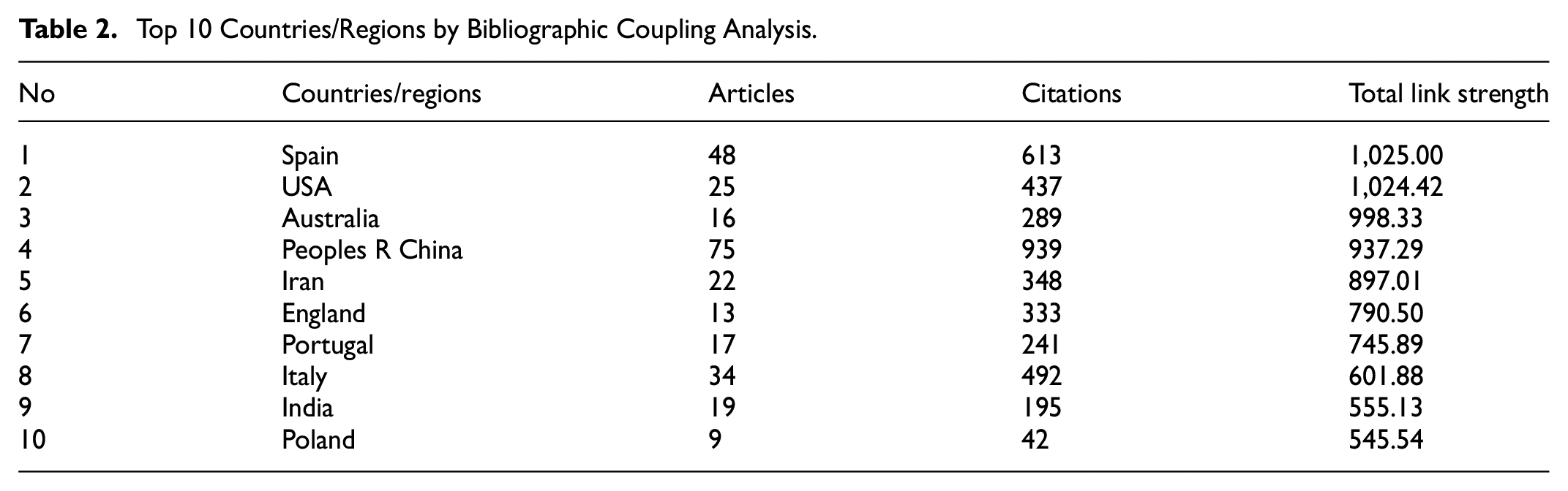
Figure 3 also shows 10 countries/regions on GIS-based tourism and sustainability articles. Based on the bibliographic coupling study, three groups of nations have been identified and there is correlation between the countries in each group. The first cluster comprises four countries: Italy, Spain, Portugal, and Poland. The second cluster comprises of four countries: India, the USA, Australia, and Iran. The third cluster consists of two countries: China and England.

Bibliographic coupling countries/regions network visualization.
For each of the 221 journals, the total strength of the bibliometric coupling links with other journals is calculated. The journals with the greatest total link strength are selected. Table 3 indicates the top 10 journals on GIS-based tourism and sustainability articles. The statistics demonstrate the top 10 journals with articles, citations, and total link strength. According to the table, the first journal is Sustainability, with 57 articles, 518 citations, and 511.15 total link strength. Then, Land Use Policy is the second with 10 articles, 354 citations, and 201.99 total link strength, and Tourism Management Perspectives is third with 4 articles, 94 citations, and 128.88 total link strength. Journal of Mountain Science, Applied Geography, Environmental Development and Sustainability, Land, Ocean & Coastal Management, Landscape and Urban Planning, and Environmental Monitoring and Assessment are the following journals.
Top 10 Journals by Bibliographic Coupling Analysis.
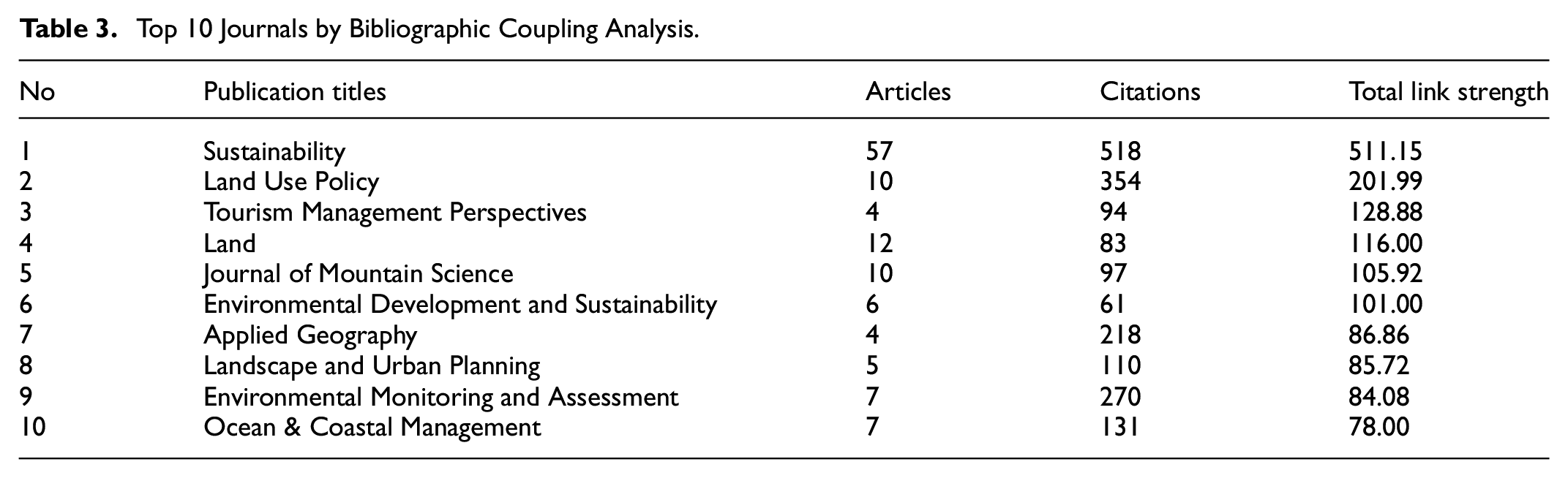
Figure 4 also shows the 10 journals on GIS-based tourism and sustainability articles. There are three clusters of journals according to the bibliographic coupling analysis and there is correlation between the journals in each cluster. The first cluster comprises five journals: Tourism Management Perspectives, Environmental Monitoring and Assessment, Environmental Development and Sustainability, Sustainability and Applied Geography. Cluster 2 consists of three journals: Journal of Mountain Science, Land and Land Use Policy. Cluster 3 consists of two journals: Landscape and Urban Planning and Ocean & Coastal Management.
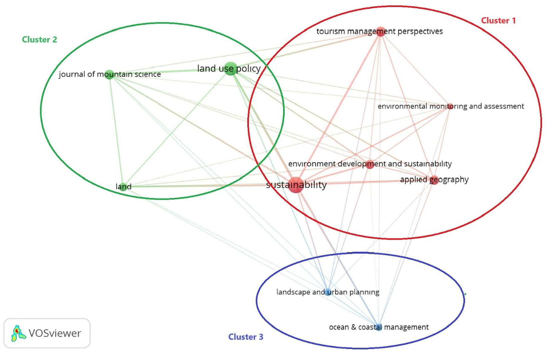
Bibliographic coupling journals network visualization.
Co-authorship Analysis
Co-authorship analysis unveils the publication output of a country as well as its international collaborations. In this research, countries/regions are utilized as the unit of analysis. For each of the 80 countries, the total strength of co-authorship links with other countries is computed. The countries with the highest total link strength are identified. Table 4 presents the top 10 countries in GIS articles related to tourism and sustainability based on co-authorship analysis. The USA leads with 25 articles, 437 citations, and a total link strength of 17.00. Following the USA, Spain ranks second with 48 articles, 613 citations, and a total link strength of 13.00, followed by Australia with 16 articles, 289 citations, and a total link strength of 12.00.
Top 10 Countries/Regions by Co-authorship Analysis.

Figure 5 depicts the top 10 countries in GIS articles related to tourism and sustainability, revealing four clusters of countries based on co-authorship analysis and there is correlation between the countries in each cluster. The first cluster includes three countries: Germany, Portugal, and Spain. The second cluster consists of three countries: Canada, Saudi Arabia, and the USA. The third cluster comprises two countries: Australia and Iran. Lastly, the fourth cluster encompasses two countries: England and China.

Co-authorship countries network visualization.
Co-citation Analysis
The closer two papers are cited together in the same publications, the stronger their relationship (Perianes-Rodriguez et al., 2016). For instance, in co-citation analysis, if papers A and B are both cited by a third paper, C (Belussi et al., 2019), it indicates a connection between A and B. In this research, journals are utilized as the unit of analysis. The total strength of co-citation connections with other sources is calculated for each of the 10,228 sources, and the journals with the strongest total links are selected. Based on tourism and sustainability, Table 5 lists the top 10 journals for GIS articles, as determined by the co-citation analysis. Just the top 10 journals in terms of publications, citations, and total link strength are shown in the statistics. According to the table, the most cited journal is Tourism Management, with 520 citations and 490.75 total link strength. Then, Sustainability-Basel is the second with 413 citations and 394.56 total link strength, and Landscape Urban Planning is third with 429 citations and 394.34 total link strength. The following journals are Annals of Tourism Research, Land Use Policy, Journal of Environmental Management, Ecological Indicators, Journal of Sustainable Tourism, Ocean & Coastal Management, and Applied Geography.
Top 10 Journals by Co-citation Analysis.

Figure 6 also presents the 10 most cited journals in the co-citations of journals network visualization. Based on co-citation analysis, two clusters are discernible and there is correlation between the journals in each cluster. The first cluster encompasses seven journals: Applied Geography, Ecological Indicators, Journal of Environmental Management, Land Use Policy, Landscape Urban Planning, Ocean & Coastal Management, and Sustainability-Basel. The second cluster consists of three journals: Annals of Tourism Research, Journal of Sustainable Tourism and Tourism Management.

Co-citations journals network visualization.
Co-occurrences of Author Keywords and Abstract Terms
The primary content of the articles is reflected in the crucial information found in the keywords (Yan & Zhiping, 2023, p. 5). For each of the 1,584 keywords, the total strength of the co-occurrence links with other keywords is calculated. Table 6 indicates the top 20 keywords on GIS articles based on tourism and sustainability according to the co-occurrence analysis. According to the table, the most frequently occurring keyword is “GIS,” with 91 occurrences and a total link strength of 92.00. Following GIS, “tourism” ranks second with 36 occurrences and a total link strength of 36.00, while “sustainable development” holds the third position with 32 occurrences and a total link strength of 32.00. The following keywords are, respectively, ecoturism, sustainable tourism, sustainability, remote sensing, spatial analysis, land use, rural tourism, AHP, geographic information system, geographic information system (GIS), climate change, urbanization, geographic information systems, PPGIS, tourism development, land use change, and cultural heritage.
Author Keywords by Co-occurrence Analysis.
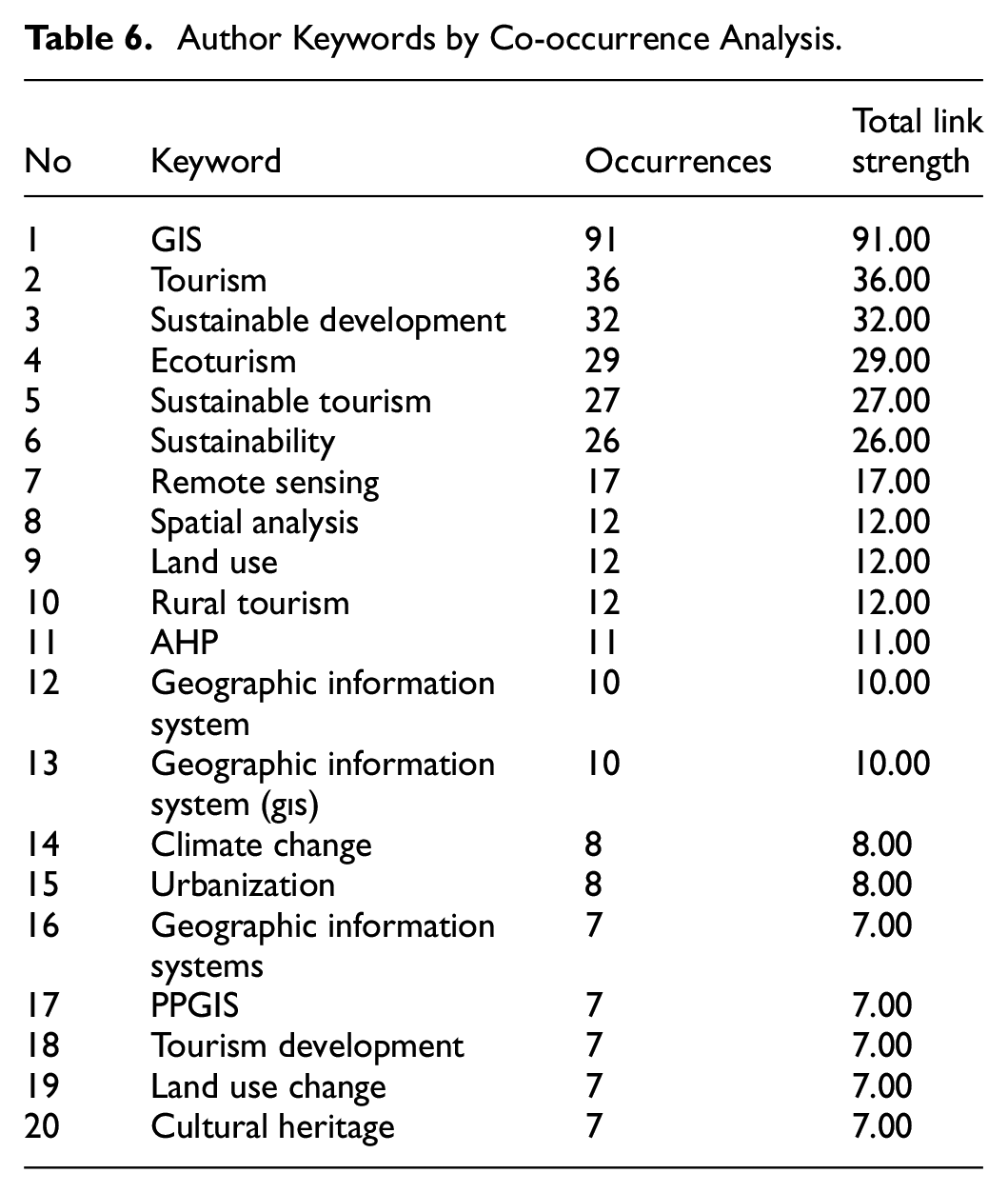
Figure 7 shows 20 recurrent author keywords on GIS-based tourism and sustainability articles. Based on the co-occurrence analysis, five term clusters were identified and there is correlation between the keywords in each cluster. The first cluster comprises five keywords: geographic information system (gıs), geographic information systems, land use change, rural tourism, and sustainable development. The second cluster comprises five keywords: GIS, remote sensing, spatial analysis, sustainability, and tourism. The third cluster comprises four keywords: AHP, climate change, ecotourism, and geographic information system. The fourth cluster consists of three keywords: cultural heritage, sustainable tourism, and urbanization. The fifth cluster comprises three keywords: land use, PPGIS, and tourism development.

Co-occurrences of author keywords network visualization.
For the 1,584 author keywords, the total strength of the co-occurrence linkages with other keywords is calculated. The density visualization of co-occurring author keywords is displayed in Figure 8. The most often occurring author keywords in GIS publications about tourism and sustainability are displayed in the red area. The color shifts from red to blue when the quantity of keyword repeats drops.
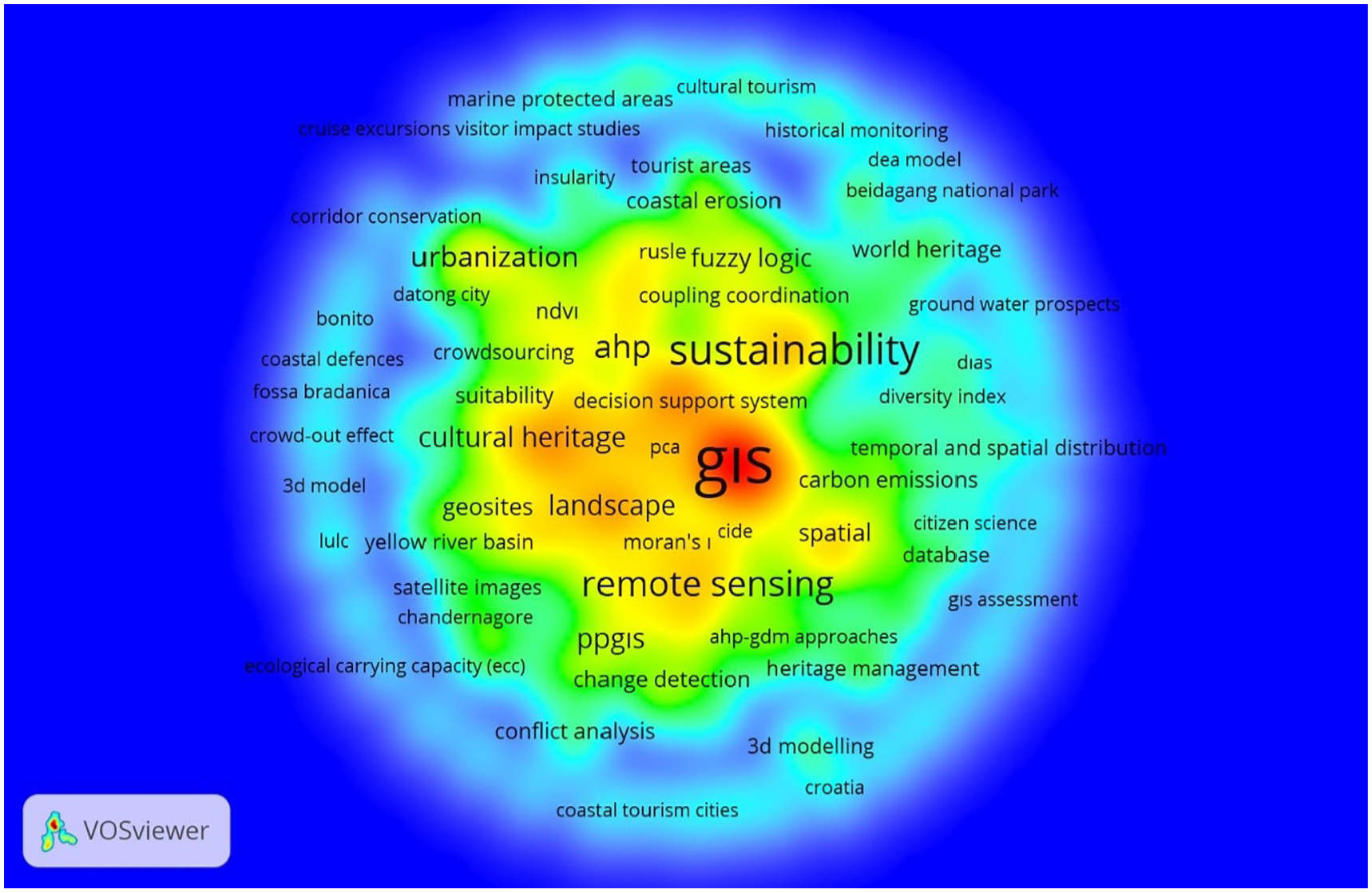
Co-occurrences of author keywords density visualization.
When working with terms, the definition of the occurrences attribute depends on the counting method. In the case of binary counting that is used in the analysis, the occurrences attribute indicates the number of documents in which a term occurs at least once (van Eck & Waltman, 2022). For each of the 275 terms out of 11,947 that repeat at least 10 times, relevance score is calculated. Table 7 indicates the 60 terms on GIS articles based on tourism and sustainability according to the relevance score. Terms with a high relevance score typically signify specific topics addressed within the abstracts, whereas terms with a low relevance score tend to be more general in nature and may not be indicative of any topic (van Eck & Waltman, 2022). According to the table, the most relevant term is “weighted linear combination,” with 10 occurrences and 5.01 relevance score. Then, “forest area” is the second with 11 occurrences and 3.58 relevance score and “analytic hierarchy process” is third with 15 occurrences and 3.01 relevance score.
Co-occurrence Analysis of Abstracts.

Figure 9 also shows 60 recurrent terms on GIS-based tourism and sustainability articles. There are two clusters of abstract terms according to the co-occurrence analysis and there is correlation between the abstract terms in each cluster. The first cluster comprises 33 terms: accessibility, ahp, analytic hierarchy process, benefit, challenge, criterium, cultural resource, decision making, ecotourism, elevation, expert, identification, interview, Iran, planner, possibility, preference, proximity, questionnaire, route, rural area, rural tourism, slope, Spain, suitability, suitable area, sustainable tourism development, territory, tourism sector, variable, visitor, weight, and weighted linear combination. The second cluster comprises 27 terms: change, climate change, coastal area, coastal zone, coastline, consideration, decrease, degradation, erosion, evolution, expansion, forest, forest area, human activity, increase, land cover, land use change, loss, monitoring, period, remote sensing, settlement, trend, Turkiye, urban area, urbanization, and vegetation.

Co-occurrences of abstract terms network visualization.
Figure 10 illustrates the density visualization of term co-occurrences. The red region highlights the most frequently occurring abstract terms in GIS articles related to tourism and sustainability. As the repetition frequency of keywords decreases, the color transitions from red to blue.

Co-occurrences of abstract terms density visualization.
WoS Categories and Sustainable Development Goals
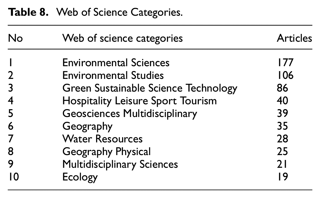
The distribution of studies in GIS-based tourism and sustainability according to Web of Science categories is shown in Table 8. According to the table, the GIS-based tourism and sustainability studies are mainly conducted under Sustainable Cities and Communities goals with 235 articles, Life on Land with 140 articles in second place, and Climate Action with 69 articles in third place. The following WoS categories are Hospitality Leisure Sport Tourism, Geosciences Multidisciplinary, Geography, Water Resources, Geography Physical, Multidisciplinary Sciences, and Ecology.
Web of Science Categories.
The distribution of studies in GIS-based tourism and sustainability according to the Sustainable Development Goals is shown in Table 9. According to the table, the studies on GIS-based tourism and sustainability are mainly conducted under the goals of Sustainable Cities and Communities with 235 articles, Life on Land with 140 articles in second place, and Climate Action with 69 articles in third place. The following sustainable development goals are Life Below Water, Clean Water and Sanitation, Zero Hunger, No Poverty, Quality Education, Good Health and Well-Being, Industry Innovation and Infrastructure, Responsible Consumption and Production, Affordable and Clean Energy, and Peace and Justice Strong Institutions. Forty-six articles do not contain data in the field being analyzed. There is no data about the goals of Gender Equality, Decent Work and Economic Growth, Reduced Inequalities, and Partnerships for the Goals.
Sustainable Development Goals.

The Most Cited Articles
Table 10 shows the most cited articles on GIS-based tourism and sustainability. The most cited article was prepared by Cetin in 2016, with 192 citations. The second most cited article was also written by Cetin in 2019, with 172 citations. The third most cited article was prepared by Nahuelhual et al. in 2013, with 170 citations.
The Most Cited Articles.

Conclusions and Discussions
GIS is one of the best tools for understanding locals’ perspectives on tourism and influencing visitors’ decisions about destinations, accessibility, time, and product availability (Ólafsdóttir & Runnström, 2009). Similarly, previous studies (e.g., Chu et al., 2012; Waleghwa & Heldt, 2022) claim that GIS-based research may increase visitor participation and improve their experiences. According to Bahaire and Elliott-White (1999), GIS has enormous potential for sustainable tourism planning and development. Hence, this paper evaluates GIS-based tourism research published in the Web of Science (WoS) database between 1996 and 2023, aiming to improve GIS techniques and make wise decisions in sustainable tourism management.
The bibliometric analysis of GIS-based tourism and sustainability research findings aligns with previous studies and contributes to this field’s ongoing development and understanding. The increasing trend in publications and citations reflects the growing interest and focus on GIS-based tourism and sustainability, consistent with the observations made by Ruhanen et al. (2015) in their 25-year bibliometric analysis of sustainable tourism research. Identifying top countries, journals, and collaborative networks provides valuable insights into this field’s research productivity and collaborative networks, aligning with the recommendations for fostering collaboration and knowledge exchange in tourism research.
The co-citation analysis of journals and the co-occurrence of author keywords shed light on the key themes and concepts central to GIS-based tourism and sustainability research, in line with the systematic review conducted by Montero and Lopez-Sanchez (2021). The analysis of journal co-citations yielded two clusters. The main fields of the journals effectively contribute to the formation of these two clusters. Upon considering the aims and focal points of the journals in the first cluster, we find that they share a common focus on environmental issues, adopt an interdisciplinary approach, adopt a global perspective, and prioritize sustainability. The journals in the second cluster share a common thread. They focus on tourism issues. The distribution of studies across Web of Science categories and Sustainable Development Goals provides valuable insights into the interdisciplinary nature of this research area, consistent with the emphasis on comprehensive literature review and evaluative bibliometric analysis in understanding the evolving trends in niche tourism products, as highlighted by.
The most cited articles in GIS-based tourism and sustainability research reflect the seminal contributions and impactful research in this field, consistent with the importance of analyzing highly cited studies to understand the trends in tourism development studies, as emphasized by. The content analysis of the selected articles reveals the diverse range of research topics and methods in GIS-based tourism and sustainability, aligning with the broader goal of sustainable tourism, as highlighted by Vuković (2022) and the evolving methodologies and tools used in evaluating the sustainability of tourism activities, as evidenced by.
Furthermore, the results highlight significant themes and terms prevalent in the literature, pushing future studies to delve deeper into these topics and investigate cutting-edge ideas and innovative GIS applications in sustainable tourism. Advanced spatial analytical methods like machine learning and big data analytics can help us better understand how tourists behave, how their actions affect the environment, and how to develop policies and strategies for sustainable tourism. The connection of GIS-based research with Sustainable Development Goals highlights the need to address urgent global concerns and utilize GIS tools for evidence-based policy formulation and decision-making, helping accomplish sustainable development targets. The preservation of natural and cultural resources while fostering economic growth and social well-being are all guaranteed by this bibliometric study, which serves as a platform for future research in GIS-based tourism and sustainability. The analysis sheds light on how GIS techniques, such as remote sensing and spatial analysis, can be applied in sustainable tourism, inspiring the creation of new theories and research methodologies for exploring the intricate relationships between tourism, sustainability, and spatial dynamics. In order to gain a thorough knowledge of the role of GIS in supporting sustainable development, theoretical frameworks can be created to investigate the synergies and trade-offs between tourism development and the SDGs. In conclusion, the applications of these findings support collaboration, direct research priority, and provide decision-making in sustainable tourism management. Theoretical implications enhance the literature on GIS-based tourism and sustainability and set the way for future research by encouraging interdisciplinary approaches, advancing GIS-based tourism research, and exploring the alignment with SDGs.
The findings from the bibliometric analysis contribute to the ongoing development and understanding of GIS-based tourism and sustainability research. The insights provided by the analysis offer valuable guidance for researchers, practitioners, and policymakers in the field. Identifying trends and patterns can inform future research directions and interdisciplinary collaborations. The references provided offer valuable insights into the diverse applications of GIS in sustainable tourism, reflecting the multifaceted nature of GIS applications in this field.
The findings from the analysis of recurrent terms and co-occurrence patterns in GIS-based tourism and sustainability articles provide valuable insights into the specific topics and themes covered in the literature. The identification of clusters of abstract terms and the visualization of co-occurrences contribute to a deeper understanding of the key concepts and areas of focus within this research domain.
The relevance score of terms, as calculated based on their occurrences and significance within the abstracts, offers a quantitative measure of the importance of specific topics. The most relevant terms, such as “weighted linear combination,”“forest area,” and “analytic hierarchy process,” shed light on the emphasis placed on spatial analysis, environmental considerations, and decision-making methodologies within GIS-based tourism and sustainability research. This aligns with previous studies that have highlighted the critical role of spatial analysis and environmental considerations in sustainable tourism management (Baggio, 2020; Connell & Page, 2008). If we interpret the words in the clusters, we can relate the first cluster to GIS for sustainable rural tourism development, the second cluster to spatial technologies for sustainable tourism, the third cluster to AHP for climate-responsive ecotourism management, the fourth cluster to heritage preservation in urban sustainable tourism, and the fifth cluster to participatory GIS for tourism land use planning. We can evaluate it within the framework of Sustainable Development Theory, emphasizing the need to harmonize economic growth, environmental protection, and social equity, as well as Geospatial Analysis Theory, which offers a fundamental understanding of the use of spatial data. Rural tourism can support the economic development of local communities while helping to conserve natural and cultural resources. We can use spatial analysis to optimize tourist flows and mitigate environmental impacts. This approach to Sustainable Development Theory addresses how ecotourism can cope with climate change and improve resource management. We can use spatial analysis to strike a balance between heritage site protection and tourism activities. This approach contributes to the development of sustainable land use plans within the framework of Sustainable Development Theory, taking into account communities’ needs and views. Geospatial analysis enhances the effectiveness of these processes.
The co-occurrence analysis reveals distinct clusters of abstract terms, each representing specific thematic areas. The first cluster encompasses terms related to accessibility, decision-making processes, sustainable tourism development, and spatial analysis techniques. This cluster reflects the multidimensional nature of GIS-based research in tourism and sustainability, highlighting the integration of geographic information systems with decision-making frameworks and sustainable development practices. This is consistent with previous research that has emphasized the importance of decision-making processes and sustainable tourism development in GIS-based studies (Ghoochani et al., 2020).
The second cluster, which includes terms such as “climate change,”“coastal area,”“land use change,” and “remote sensing,” underscores the significance of environmental and ecological considerations within GIS-based tourism and sustainability studies. This cluster reflects the growing focus on environmental monitoring, land use dynamics, and the impact of climate change on tourism destinations. This is in line with existing literature that has highlighted the importance of environmental monitoring and the impact of climate change on tourism destinations (Jamkhaneh et al., 2022; Mihalič & Kuščer, 2021).
The visualization of co-occurrences in Figure 10 further emphasizes the prevalence of specific keywords and their varying degrees of repetition. The identification of the most repeated author keywords provides valuable insights into the key thematic areas and research priorities within GIS-based tourism and sustainability literature. This supports the existing literature on the significance of specific keywords and their relevance in representing key thematic areas within GIS-based tourism and sustainability research (Cooper, 2018).
Comparing these findings with existing literature, the emphasis on decision-making processes, environmental considerations, and sustainable tourism development aligns with previous research on the integration of GIS in tourism planning, environmental management, and sustainable development. The identified clusters of terms and their co-occurrence patterns contribute to the ongoing discourse on the application of GIS in addressing environmental challenges, enhancing tourism accessibility, and promoting sustainable tourism practices. This is consistent with previous studies that have highlighted the multidimensional nature of GIS-based research in tourism and sustainability (Hamimah et al., 2022).
One of the biggest challenges facing the tourism sector today is the integration of tourism data with GIS data (Jovanovic & Njeguš, 2008). The increase in the number of articles indicates that the study of GIS-based tourism research in the global academic community is developing rapidly. According to the distribution of articles in different countries, Spain, the USA, and Australia rank in the top three, which indicates that these countries are the development centers and active areas of GIS-based tourism research. Furthermore, the country/nation analyses rank Iran and Saudi Arabia, both Middle East countries, in the top 10. This indicates the progress the region has made in this field. This finding indicates that researchers have studied the subject in various regions. Sustainability, Land Use Policy, and Tourism Management Perspectives are authoritative journals in the field of GIS-based tourism research, according to the bibliographic coupling analysis. When the top 10 most cited studies in GIS-based tourism research are examined, it is seen that there are more studies conducted in Türkiye. This indicates that Türkiye plays a notable role in GIS-based tourism research.
GIS provides direct services for tourist management because it has the capability to gather, store, process, analyze, and more. The ability to create an extensive thematic map and manage tourism information are the two primary functions of GIS in tourism management (Wei, 2012). Geographic information systems (GIS) aim to guide the development of a comprehensive system for managing tourism destinations, combining and organizing data currently stored on separate platforms (Levy & Dickson, 2006). Geotagged photos in tourism display places and times of high visitor density. Thus, this method, particularly in protected areas, provides reliable data for management actions like trail maintenance and the introduction of use limits (Orsi & Geneletti, 2013). Today, the majority of GIS applications in tourism are in the areas of inventorying recreational capacities, managing land use for tourism, evaluating visitor impact, identifying conflicts between mapping recreation and environment, developing a tourist information management system, and supporting decision-making (Cvetkovic & Jovanovic, 2016). In the context of smart tourism, a map that contains geographical information may help a tourist make decisions more quickly. For example, a traveler can quickly search, evaluate, and analyze a wealth of travel-related information with the aid of geotagged posts and images about a certain place.
In conclusion, the findings from the analysis of recurrent terms and co-occurrence patterns contribute to the ongoing development of GIS-based tourism and sustainability research. The insights provided by the analysis offer valuable guidance for future research directions, interdisciplinary collaborations, and evidence-based policy formulation in the context of sustainable tourism management. This supports the existing literature on the importance of recurrent terms and co-occurrence patterns in guiding future research and policy formulation in GIS-based tourism and sustainability (Rembulan & Kusumowidagdo, 2021).
The findings from this research contribute significantly to the theoretical background by reinforcing the principles of Sustainable Development Theory, which advocates for a holistic approach to tourism that balances economic growth with environmental sustainability and social equity. The application of GIS in tourism planning exemplifies how spatial analysis can facilitate informed decision-making that aligns with sustainable development goals. Additionally, the introduction of the Geospatial Analysis Theory enhances the existing literature on the application of geographic information systems (GIS) in the field of tourism. It provides an advanced analytical set of tools and techniques for assessing and visualizing complicated spatial relationships that have not been fully understood. This is particularly the case for impacts that the tourism industry does not have on relationships among local communities, their environments, and the tourism economy.
Even though this study offers insightful information about GIS-based tourism and sustainability research, it is crucial to recognize its limitations. The analysis was conducted based on data from the Web of Science (WoS) database, which might include only some pertinent articles. In addition, the 1996 to 2023 timeframe and restricted search phrases utilized in the investigation may have constrained the search query. Data analysis methods like co-authorship, co-citation, and co-occurrence analysis have drawbacks. The study focuses on GIS-based tourism and sustainability research from a worldwide viewpoint. However, the results could be skewed due to regional biases, with some nations or regions being overrepresented or underrepresented in the analysis. Citation numbers do not always represent the caliber or rigor of the research, and quality assessments of the included publications are not provided.
Future research should diversify data sources, broaden search terms, include non-English literature, extend the timeframe, and update data, incorporate qualitative analysis, take into account regional and contextual analysis, evaluate research quality, explore emerging technologies, address interdisciplinary gaps, and include stakeholder perspectives to get around these limitations. Future studies can contribute to the area and develop sustainable tourist management techniques by addressing the shortcomings of these recommendations, broadening the research’s scope, and improving knowledge and comprehension of GIS-based tourism and sustainability research.
Footnotes
Ethical Considerations
We testify that our article submitted to Sage Open not published in whole. However, its abstract was presented at the 9th EATSA Conference held in India on the 14th of September 2023, and it was published in the abstract proceedings of the conference. All authors have been personally and actively involved in substantive work leading to the manuscript and will hold themselves jointly and individually responsible for its content.
Funding
The author(s) received no financial support for the research, authorship, and/or publication of this article.
Declaration of Conflicting Interests
The author(s) declared no potential conflicts of interest with respect to the research, authorship, and/or publication of this article.
Data Availability Statement
The dataset generated during and/or analyzed during the current study are available from the corresponding author on reasonable request.