
Abstract
The increasing dissemination of geographic information systems (GIS) in recent years has broadened the availability and use of geospatial tools, mostly to analyze the spatial data of different territories. A territory can be viewed at different analysis scales, and some buildings are as complex as small cities, presenting the opportunity to use GIS to study the dynamics, patterns, and phenomena within a building. This study presents a systematic literature review of the relevant evidence focused on the utilization of GIS in indoor spaces. To this end, we searched in three scientific libraries following the PRISMA statement guidelines. All phases were analyzed independently by two of the authors and agreement between them calculated through the Kappa statistic. In total, 50 studies were included. A qualitative synthesis was performed, considering the assessment of data and heterogeneity of methodologies within the included articles. Subsequently, the studies were categorized into five groups: indoor management, indoor geospatial analysis, indoor positioning, indoor data acquisition, and indoor spatial data models. The results demonstrate that research on the use of GIS in indoor spaces is still emerging, despite its great potential to help and GIS users, data producers, researchers, or policymakers to improve their work, providing scientific evidence for decision support.
Introduction
A Geographical Information System (GIS) can be characterized as a decision support system framework which is designed to acquire, organize, manage, analyze, and visualize spatial and alphanumeric data (Duckham et al., 2003; Goodchild, 2009b, 2010). The first use of the term GIS was credited to Roger Tomlinson at the beginning of the 1960s, developing the ideas and knowledge that led to the tools used at present (Wing & Bettinger, 2003). In the late 1980s, specialists in a wide variety of scientific areas started to use GIS at a larger scale, due to the better accessibility of spatial information (Karimi & Akinci, 2009; Waters, 2018), and since maps became into powerful analytical devices, instead of being merely descriptive (Maliene et al., 2011; Teixeira & Pina, 2018). Indeed, they started to produce data and integrate additional analysis or comprehension tasks related to spatiotemporal clusters and statistical analysis into layers on top of a base map (Wieczorek & Delmerico, 2009). Nowadays, geospatial data is familiar to virtually everyone, providing vast potentialities to evaluate the GIS multidisciplinary and multiparadigmatic natures (Blaschke & Merschdorf, 2014).
Usually, other scientific areas than geography or cartography are ever more associated with these tools, such as health, computer vision, computational geometry, remote sensing, robotics, or architecture, for example, proving that there are no boundaries for GIS (Kumar & Shekhar, 2016; Obaidat & Al-kheder, 2006). Health researchers classically use GIS for processing, analyzing, and visualizing spatial data about diseases (Goodchild, 2009a). At the same time computer vision operators focus on the extraction process of highly accurate data, presenting spatial data inventory, introducing numerous analytical procedures, and developing advanced and sophisticated technical systems (Kistemann et al., 2002). Engineering or geometry usually integrate GIS data with a Building Information Model (BIM) mainly to analyze the existing spatial relationships, leading to tremendous improvements in efficiency, cost containment, and better decision-making (Kang & Hong, 2015; Zhang et al., 2009). Furthermore, some architects have used those tools to calculate isovists; such software can be applied to save and explore the spatial properties of the graphic structure inherent in space (Llobera, 2003).
Despite its incredible evolution in recent decades, the comprehension related to spatial information has not changed over time, with different GIS approaches, being applied and considering geographical features (such as neighborhoods, cities, and regions) of an external territory (Misra et al., 2020; Teixeira & Pina, 2018). However, at this moment, it is pointless to constrain the term “place” to an external territory since 80% of people’s daily lives are being spent within indoor spaces (Deng et al., 2013). According to Santos (1996) definition, a territory is a space where people and processes interact, in which history, dynamics, and phenomena take place, and does not necessarily have to be open-air (Zlatanova et al., 2014). Space characterization is a critical advance, providing a better understanding of it (Mennis & Yoo, 2018), since space, which is being studied today, is no longer restricted to being outdoors but can also be extended to the indoors (Li, 2008).
Indoor space varies from outdoor space in many characteristics. Outer space can be defined as a portion of land which is not enclosed by some environment, while indoor space is typically bounded and constrained by an architectural structure (Goetz, 2012; Li, 2008; Vanclooster et al., 2012; Worboys, 2011; Zlatanova et al., 2020). Besides that, the basic concepts, models, and standards must be redefined to encounter the requirements of indoor spatial applications, without necessarily changing the approaches. An excellent example of a proposed standard spatial data model for indoor space is the IndoorGML since it represents all the properties addressed in the model, such as geometry, symbolic space, network topology, and spatial reference (Afyouni et al., 2012).
Although indoor spaces are already being the target of several research approaches, not many researchers are using GIS, and their theories and data models. The raw data related to these spaces, need to present a viable collection method, since it is needed to show and correctly represent the space, with all associated information and integrating the topology concept (Afyouni et al., 2012; Kang & Li, 2017).
Consequently, reproducing the traditional use of GIS—which is more oriented to analyze the geographical territory—into another type of space, such as buildings, is a challenging task which could be extremely interesting for researchers from a wide variety of study areas, triggering essential developments in some works; due to the variety of complex infrastructures, such as hospitals or industrial centers, for example, with a high circulation of persons per day (Goetz, 2012).
To our knowledge, no review of studies associated to GIS utilization in indoor spaces has been published so far. Given the lately interest and the practical demand for it, in this paper, we aim to carry out a systematic review of the literature to identify and summarize the scientific evidence related to GIS utilization to modeling the indoor space or to analyze and comprehend the spatial phenomena which is occurring in this type of environment.
Our contributions are as follows: (1) we gave an overview of the applied methods for evaluating the GIS utilization in indoor spaces; (2) we identified the included papers and extracted its mains outcomes; (3) we grouped the studies and constructed an index co-occurrence of the included articles keywords; and (4) we discussed the results and highlighted the challenges and opportunities for future works.
Materials and Methods
To provide insights into various aspects of GIS applications to explore the distribution of events and dynamics happening within the indoor spaces, we evaluated and filtered a wide variety of publications based on a systematic literature review process. Even though this review process was initially associated to the medical research area, it has been used lately into another studies areas, such as GIS, for example (Klonner et al., 2016; Steiger et al., 2015; Unrau & Kray, 2019). It was applied to ensure that the selection of the included documents was based on clear eligibility criteria, making it less subject to bias, in order to answer the study specific question, providing methods that can be systematically described and reproducible (Randolph, 2009; Torraco, 2005).
The systematic literature review was performed independently by two of the authors (HT and AM), according to the guidelines presented by the PRISMA Statement (Moher et al., 2009), to carry out a critical and comprehensive qualitative review.
Eligibility Criteria
The included studies satisfied the following criteria:
(1) Original research papers which address the issue of the utilization of GIS in indoor spaces/environments.
(2) Studies analyzing data from indoor spaces of buildings, such as factories, companies, hospitals, malls, and universities.
(3) Studies providing indoor modeling/navigation techniques.
(4) Indoor Positioning studies using wireless sensors or GPS devices.
(5) Data acquisition studies using robots or deployed devices.
Studies were excluded for the following reasons:
(1) Studies using GIS methods applied to external physical territories, such as land-use, river basins, rivers, seismicity, and natural hazards.
(2) Original papers focusing on demographic data and, or the evolution of urban growth using 3D models of cities and landscapes such as CityGML—the interior of the building is the goal of this review analysis, not the set of buildings.
(3) Building Information Model (BIM) papers—despite the two technologies being complementary (GIS and BIM), BIM are often seen as the new generation of CAD tools and the paper focus is the GIS and its application to the indoor spaces.
(4) Non-original articles, non-peer-reviewed books of conference proceedings, dissertations, and studies that are providing duplicated information.
These eligibility criteria were considered in the four phases of the systematic review, which are described in the following subsections.
Identification Phase
The selection of terms to search for the articles is an essential process, since it, determines the number of studies found. For choosing the set of query terms, we used the subsequent strategy. First, we created a list of all reasonable terms, and two rounds of tests with the various terms were carried out. In these rounds, the terms were quantitatively analyzed, and the confirmation of related relevant studies was observed. There were no missings for the selection. Subsequently, the terms were tested in a single expression and “placing and removing” terms from the search expression, to identify whether there are chances of loss of relevant articles. Tests were performed for the composition of the three domains: GIS, indoor and spatio-temporal analysis. As well, the defined criteria were applied to build the query, and it was calibrated using MEDLINE (MeSH), as it offers an extensive dictionary of indexing terms (MeSH terms). The query string was used, with no restriction regarding the language of publication: (“GIS” OR “Geographic* Information System*” OR “Geographic* Information Science*” OR “Global Positioning System*” OR “Geographic* mapping” OR “Mapping” OR “Georeferencing”) AND (“building*” OR “edifice*” OR “premise*” OR “facility” OR “indoor” OR “indoor modeling” OR “indoor navigation” OR “inside” OR “hospital*”) AND (“Spatio Temporal” OR “Spatio-Temporal” OR “Spatial Temporal” OR “Spatiotemporal” OR “Geoanalysis”), which was applied to SCOPUS, Web of Science, and MEDLINE databases, from inception to April 30th, 2020.
Screening Phase
Eligibility criteria were assessed by reading titles and abstracts resulting from the search expression. In this phase, the authors (HT and AM) independently screened the database, searching all retrieved articles, titles, and abstracts by peer review. The resolution of divergences was solved by the consensus method, and concordance evaluation was measured using the Kappa statistic with corresponding 95% confidence interval (CI). Cohen’s kappa coefficient (κ) is a statistic utilized to measure inter-rater reliability (and intra-ratter reliability) for qualitative (categorical) items, in the case of this study, “INCLUDE” or “EXCLUDE.” It is a more robust measure than the simple percentage calculation of agreement (Kraemer, 2014). The reproducibility process was evaluated to ensure the transparency of the employed methods, allowing any user to address the same question and identify the same set of studies to reach a similar general conclusion.
Eligibility Phase
After the screening phase, all potential candidate articles were evaluated in full-text format. In this phase, the same authors (HT and AM) scrutinized the entire text of the studies to ensure their eligibility, using the criteria defined for inclusion or exclusion. Furthermore, the authors checked the reference lists of each eligible study, searching for any which were omitted in the database search. Once again, a concordance evaluation measure was evaluated through the Kappa statistic with corresponding 95% CI, and the divergences were solved by consensus. A record of the reasons for exclusion was also drawn up at this stage and then, the final list of included articles for qualitative synthesis was completed.
Data Extraction and Subgroup Criteria
The evaluation findings in the reviewed publications covered an extensive range of GIS usability in indoor spaces with different levels of detail. We classified the included publications into five categories, according to their applied analyses and findings, as described in the following.
(1) Indoor management: studies related with network analysis (including route planning optimization, optimal service areas, or carrying out location-allocation (Kamilaris & Ostermann, 2018)); emergency response analysis studies (allowing quicker and adequate decision-making in both offline and real-time contexts (Chiu & Liu, 2008; Franzese & Liu, 2008)); and facility management or multicriteria decision support studies (Chakhar & Mousseau, 2017; Crossland, 2017; Worboys, 2011).
(2) Indoor geospatial analysis: studies using spatial analysis methods to find patterns or detect anomalies, and test hypotheses and theories (Goodchild, 2008, 2009a) within indoor environments; and visualization technique studies to comprehend and study several features and dynamics occurring within complex indoor spaces (Yuan, 2008).
(3) Indoor positioning: studies using this type of technique to track an individual’s movement (Youssef, 2015); estimating the location of target objects from observation of data collected by a set of sensing devices or sensors (Caron et al., 2008; Kanaan et al., 2008; Yang & Li, 2008); and location-based service studies using geographic data to provide information to users, supporting additional information related to that location such as a point of interest or a street address (Francica, 2008).
(4) Indoor data acquisition: studies about indoor data collection and modeling (including automatic extraction techniques (Heipke, 2008), or information acquirement through Wi-Fi, GPS, automata cellular data, and sensors (Kalogeraki & Soheili, 2008; Rolf, 2001)); and studies using the human–robot interaction approach to enlarge the semantic information related to indoor GIS.
(5) Indoor spatial data models: studies related to the development of spatial data models, enabling the representation of the indoor environments using GIS (Afyouni et al., 2012; Hughes et al., 2014).
After categorization, we analyzed the qualitative data collection approaches used in the different studies and their aims, methodological lines, and main findings.
Results
Search and Study Selection
As a result of our database search, a total of 1,533 articles were returned; of these, 986 were from Scopus, 452 from Web of Science (WOS), and 95 from Pubmed®. After the removal of duplicate articles, 1,036 scientific articles were obtained (Figure 1).
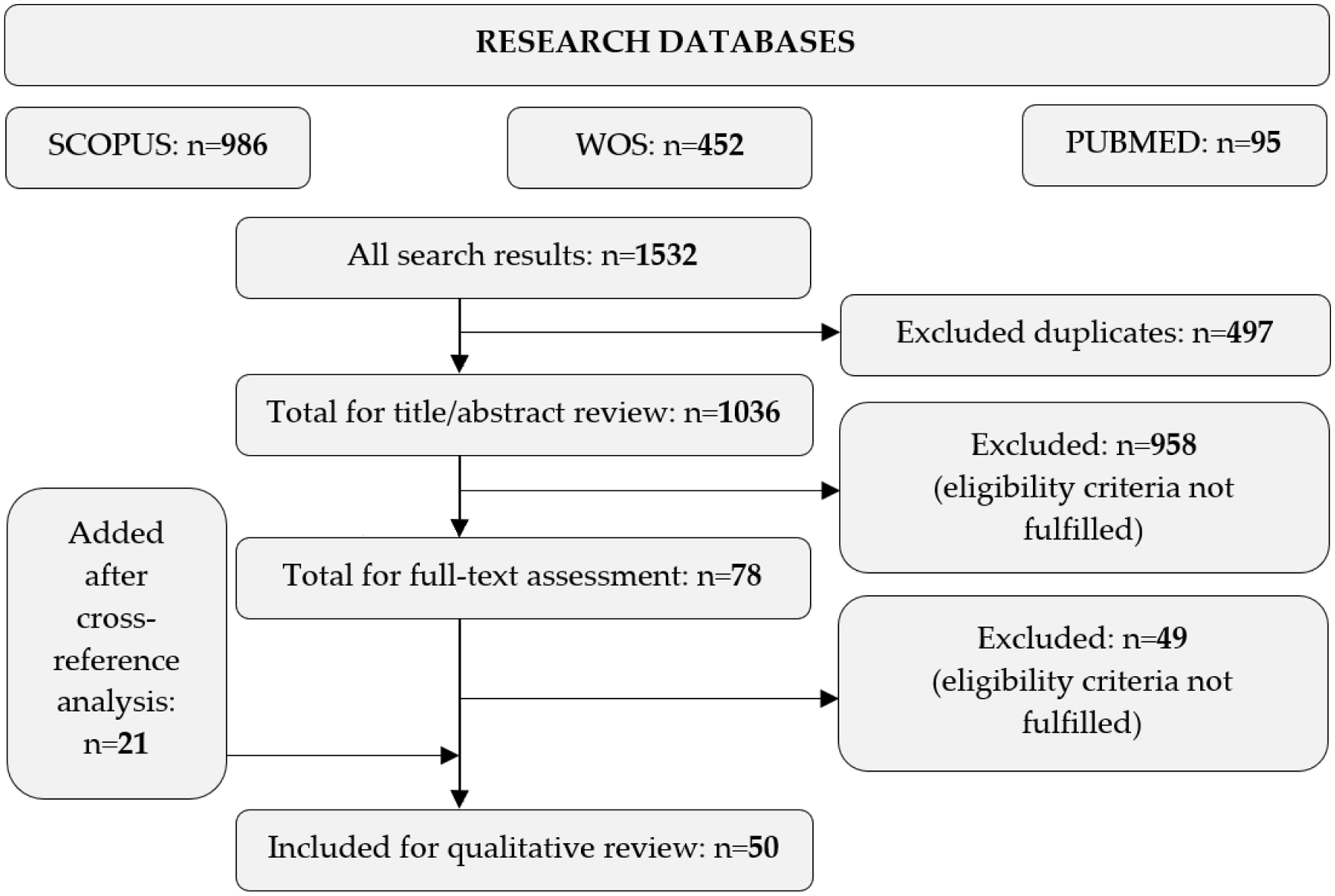
Article inclusion flowchart.
Two of the authors (HT and HM) independently examined all titles and abstracts according to relevance and, after the application of eligibility criteria, most of the studies (n = 958) were excluded.
An agreement meeting between the two reviewers was held at the end of this phase. Concordance evaluation by Kappa statistic resulted in .562 (95% CI = 0.452–0.671), which indicates moderate agreement; thus, the analysis of eligibility for inclusion was carried out, with full-text reading. The second phase started with 78 articles which were wisely scrutinized independently by the two reviewers based on the eligibility criteria. We excluded 49 studies after full-text analysis, for the following reasons: 31% focused on spatio-temporal analyses, but not within indoor spaces; 23% of the articles did not model GIS in an indoor space; 20% used robotics, but not to acquire data related to indoor spaces; 16% of the articles contained exclusion criteria features, such as the evolution of urban growth or the utilization of GIS methods for external territories; and 10% were excluded due to the unavailability of a full text, even after contact with the author.
Twenty-one studies were added after the cross-reference analysis, resulting in a total of 50 articles. In the same way, we performed a concordance evaluation that resulted in Kappa = .894 (95% CI = 0.778–1.000). After reading the articles in their full text-format and the consensus meeting between the reviewers, articles were selected for the extraction phase. The included studies characteristics are presented in Table 1, as detailed by authorship, year, country, setting, primary outcome, and subgroup assignment. From the 50 articles included in the qualitative synthesis, 12 were developed in North America, 22 in Europe, and 16 in countries and territories from Asia and Australia. The settings used in several studies ranged from public service buildings (n = 11), offices (n = 12), university buildings (n = 17), or even fictional models (n = 6) and others (n = 4).
Characteristics of Included Studies, Detailed by Authorship, Year, Territory, Setting, Main Outcome, and Subgroup Assignment.

An association between the terms appearing most commonly within the 50 included studies were made, using the VOS viewer software (Figure 2).

Co-occurrence of index or author keywords. The colors represent the clusters created based on co-occurrence of keywords, and the size of the circles represents the number of articles. The minimum occurrence of the words plotted was 5.
Checking the Figure 2 we realize that the words “GIS,” “Three-dimensional,” “indoor space” and “spatio-temporal” are those that have a stronger correlation, representing the searched domains that we intend to study and understand in the first place.
Subgroup Analysis
At this point, a descriptive synthesis is given to explain the different study methodologies by subgroup (Figure 3).

Treemap visualization of the of articles by category, after the full-text screening.
Indoor management
This subgroup represents 24% (n = 12) of the studies identified in this review. A reasonable number of articles emphasized emergency evacuation or rescue, using GIS to plan for this type of situation adequately. Kwan and Lee (2005) employed an integrating solution based on a decision support system for management of emergency response, providing the automatic calculation of shortest routes in a navigable three-dimensional GIS. The work developed by Pu and Zlatanova (2005) presented a new concept of evacuation route calculation for indoor spaces using three-dimensional models, take into consideration dynamic factors such as human movements or environmental problems. The study developed by Lee and Kwan (2014) had an emphasis on the construction of an optimal route, for emergency response and evacuation within the indoor space of a building. The authors Liu and Zlatanova (2015) carried out navigation and routing study based on an approach to compute indoor paths avoiding obstacles, allowing the user to create navigation networks with different dimensions. Wu and Chen (2012) elaborated a study based on fire-fighting search and rescue route analysis providing an emergency response support system. Tang and Ren (2012) represented, within a uniform framework, a GIS-based simulation model to generate an entire evacuation process automatically. Some studies (Chen et al., 2019; Schabus & Scholz, 2015; Schabus et al., 2017; Scholz & Schabus, 2017) focused on smart manufacturing, using GIS to perform indoor space analysis, allowing for understanding and optimization of the systems, data, and processes (Schabus & Scholz, 2015; Schabus et al., 2017). Scholz and Schabus (2017) worked on the construction of an optimal path calculation inside a manufacturing environment. Chen et al. (2019) established a GIS-based index system, which was used to address energy-saving issues, allowing for optimal operation and management of space heating and cooling systems in indoor spaces, thus supporting decisions. Finally, the articles developed by Dao et al. (2012) and Zhou et al. (2015) emphasized the creation of an optimal service area within multistory buildings, with the goal of the placement of emergency medical devices. They are using improved three-dimensional visualization techniques and the indoor network, to support the location planning of such devices.
Indoor geospatial analysis
This subgroup represents 14% (n = 7) of studies identified in this review. Bhattacharya et al. (2015) developed an algorithm which calculates line count inference and spatio-temporal density estimation to predict places of interest inside buildings in an automatic manner. Wan et al. (2017) established an operational framework based on people’s constant activities, using Global Positioning System (GPS) to collect information in both indoor and outdoor environments, allowing for the calculation of activity patterns and creating valuable data about people’s life routes. Yuan (2007) used cellular automata to simulate the movements of walkers inside a gallery building, allowing for the spatial-temporal analysis of their patterns. Kho et al. (2006) implemented a GIS-based software for infection control within hospital wards. Therefore, the authors were able to realize and conclude that this technology should be used as a nosocomial infection surveillance tool. Lake et al. (2015) developed several hazard maps related to workplace noise. They intend to identify patterns and areas of higher risk with the view to potentially help noisy working environments by clearly indicating where the high-risk places are located, thus protecting its workers. Qi and Du (2013) presented an experimental analysis method which includes automatic pre-processing, activity space characterization, trajectory segmentation, visualization, and density estimation using GPS. Vanclooster et al. (2012) defined a new measure (exitability) for indoor contexts, quantifying the quality of access to exits. This exitability measure calculates the accessibility not based on exclusively geometrical parameters, but also the movements of people.
Indoor positioning
This subgroup represents 12% (n = 6) of studies selected in this review. Ai et al. (2020) proposed a fast fingerprint construction, to allow the information collection that only requires sparse sampling of the received signal strength of the space, based on indoor localization. The study made by Coumans (2018) emphasized the human–machine interaction in smart production environments for indoor positioning, production asset monitoring, orientation, location-based management, and operational safety, as well as the situational perception of personnel and machines. Cheng et al. (2019) utilized a random walk approach to identify the spatial distributions of smoke intrusion based on an indoor positioning technique. Energy sustainability is essential to effective management (Kumar, 2019), and for that reason, Anjana et al. (2016) implemented a system within a building based on smart positioning, to fulfill that purpose.
The indoor system, implemented in one algorithm, can determine a person’s exact position, and can suitably control nearby electrical applications, thus saving energy. The study of Panta and Sèdes (2016) contributed to the understanding of a comprehensive framework related to sensor networks deployed within indoor spaces and usage of their generated information. Goetz (2012) used crowdsourced information associated with indoor spaces to develop a three-dimensional routing web app, allowing for the exploration and computation of routes and room visualization within an indoor space.
Indoor data acquisition
This subgroup represents 20% (n = 10) of the studies identified in this review. Several studies focused on human–robot interactions, allowing for the acquisition of indoor topological data as performed inside a building, resulting in the generation of dynamic maps. Będkowski et al. (2016) used mobile robots and the simultaneous localization and mapping (SLAM) algorithm to acquire three-dimensional data, to map the indoor space of some buildings, as well as perform and optimize specific security tasks. Mitsou and Tzafestas (2007) presented an innovative way to map dynamic indoor environments using mobile robots and a temporary occupancy grid. One of the advantages of this procedure is that it allows the extraction of information related to moving or static objects. However, the authors admit that the SLAM algorithm would be an asset for the work and will integrate it in future works. Rituerto et al. (2014) developed an augmented topological mapping solution based on omnidirectional vision and using the catadioptric image. Schaffernicht et al. (2017) used mobile robots to close the gap of the resulting measurements between learned local interpolation models and sensor nodes in indoor environments. Ishikawa et al. (2005) used a system based on mobile robot mapping three-dimensional data segmentation for exploration and surveillance of disaster areas. Wang et al. (2015) studied a navigation and pathway mapping approach based on Wi-Fi or cellular signals which, according to the logical map constructed, allows for guiding users to points of interest. Wong et al. (2010) used an approach based on SLAM association with robotic wireless sensor nodes network for data collection and mapping of indoor spaces. Xiong et al. (2017) converted indoor spaces into grids and automatically extracted the data from a building model. Nonetheless, the granularity of discrete grids determines the precision of indoor space modeling. This new method of extraction is commonly used in complex building models, with the right boundaries and structures. Zlatanova et al. (2014) presented an overview of approaches for indoor space subdivision for the purpose of indoor navigation, classifying the type of navigation (grid or graph), and provide its analysis. Pang et al. (2018) analyzed complex indoor environments in detail, presenting a new approach based on space boundary calculation for data extraction and reconstruction of such buildings.
Indoor spatial data models
This subgroup intended to select the studies related to the development of spatial data models to represent the indoor space. Fifteen articles were identified, representing 30% of the total articles included in the review. Several models were produced to be used at emergency response. The study produced by Lee (2007) focused on the application of a three-dimensional navigable data model, based on a spatio-temporal optimal route algorithm (the Dijkstra algorithm) for emergency response. Another study elaborated by Lee (2008) had an emphasis on the analysis of three-dimensional geospatial information models to manage emergency systems and improve the decision-making process. Ikeda et al. (2007) constructed an indoor spatial model for emergency response, based on sensors collected data. Song et al. (2019) developed a combinatorial spatial data model based on GIS to represent the indoor space of a building. The main goal was to provide enough information through fire simulation scenarios and analysis to support the decision-making process in case of emergency response. Tashakkori et al. (2015) elaborated a three-dimensional spatial data model to represent the indoor space of buildings, to provide fast response for fire-fighting rescue and route analysis in emergency case. Meijers et al. (2005) implemented a three-dimensional GIS-based indoor model, to be able to perform the calculation of the most accessible evacuation routes in case of a calamity. Xu et al. (2013) proposed a spatiotemporal-oriented three-dimensional model to represent the indoor space, which could be used to simulate indoor fire disasters in different scenarios. However, not all the presented models by the different grouped studies were made for emergency response. The study published by Billen and Zlatanova (2003) highlighted some concepts related to spatial relationships and cadaster techniques through the modeling and application of topology to develop a three-dimensional GIS model of buildings. Hussein et al. (2012) developed a flexible and expressive model capable of space plan segmentation to represent outdoor and indoor spaces based on data collection by receptor deployments. Song et al. (2016) employed a grid-based graph data model through a rasterization process, enable to represent the pedestrian routes within micro-spatial spaces, such as indoor environments. Goetz and Zipf (2011) developed an advanced model which represents indoor environments with topologic, semantic, and metric information (room labels, door accessibilities, stairways, or lifts) that allows nearly length-optimal routing in complex building structures. The work of Zlatanova et al. (2013) emphasized on the extraction process of indoor space information model through identifying the boundaries from three-dimensional data. This framework focusses specifically on physical and conceptual units of indoor space, which supports its localization and navigation. The works developed by Becker et al. (2009, 2008) emphasis on the construction of a multilayered space model, in which every single form of logical and physical feature is mapped in its space layer, with a novel concept since different semantic criteria can be applied to it. This model can be used for route planning, tracking and location. Finally, Saygi et al. (2018) carried out the implementation of an information management platform model to represent the indoor space of historical buildings, to provide better and well-informed decisions, such as the planning of restoration projects.
Discussion
This study provides a detailed review by screening several techniques and procedures to represent and model indoor spaces, which have broad applicability and can be vital and decisive for GIS users, data producers, and policymakers. The selected papers (n = 50) presented a publication year median of 2014, thereby bringing relevant information that should not be overlooked. From these papers, data collection approaches and primary outcomes were extracted, and a subgroup analysis (five categories were identified—Figure 3) was performed. The qualitative synthesis presented was fundamental to organize and summarize the gathered scientific evidence.
Indoor management contemplates studies using GIS technologies to comprehend the indoor spaces of buildings (inside and out) at a single location, providing resource exploration management, and process optimization (Chakhar & Mousseau, 2017; Chiu & Liu, 2008; Crossland, 2017; Franzese & Liu, 2008; Kamilaris & Ostermann, 2018; Worboys, 2011). The 9/11 terrorist attacks triggered the development of several studies (Kwan & Lee, 2005) concerned with the utilization of emergency response techniques in micro-spatial environments using the existing proposed standard models. These types of studies are presenting some interesting possibilities for analysis, such as scenario simulation, victim tracking and rescue, facility and resource vulnerability, real-time data delivery, data availability, and air monitoring (Kevany, 2011). The limitations of this type of approach have been identified, as it is necessary to identify the affected rooms and floors by the emergency. The verification of the occupation area is a fundamental task since it is needed to allow the system to calculate, in a viable way, a safe evacuation route (Zhou et al., 2015).
Regarding the indoor settings of production or working places, the three-dimensional visualization techniques are being used to perform optimization of the systems, routes, data, and processes, allowing better management of the associated costs, security, and action performance (Scholz & Schabus, 2017; Worboys, 2011; Zhou et al., 2015). Nonetheless, limitations have been described; for example, the amount of data and the complexity of the geometric and topological models used might favor the non-use of the system at its full potential. This process often leaves opportunities to gain a more detailed understanding of the unexploited problem (Zhou et al., 2015). In summary, the articles included in this group, intended to apply extended uses to the pre-existing models, valuing the spatial-temporal analysis to contribute for an efficient management of these spaces. The visualization, interpretation and validation approaches are the most used to optimize and enhance the expected results.
Although the “indoor geospatial analysis” subgroup might be considered the one with the most significant margin of development, it is currently under-explored with relation to the other categories. The reason for this fact may be interconnected with data availability and the lack of experience of researchers in geospatial studies that analyze the phenomena occurring within the indoor spaces. In this type of study, understanding the dynamics, movements, behaviors, and interactions of people within buildings is a fundamental condition, leading to the development of solutions which are essential for the existing problems (Goodchild et al., 2007; Yuan, 2007). Despite the heterogeneity present in the included studies, their applied mapping skills were the same, using data model representation, visualization, and simulation (Kho et al., 2006). In fact, a benefit that emerges from this type of studies is the creation of indoor space scenario models, which offers one of the most thoughtful possibilities for analysis, as the outcomes give clues that make the process of data inspection easier, helping to identify potential problems and generate solutions (Yuan, 2007, 2008). Of the several studies included in this subgroup, only one addressed the utilization of GIS to comprehend the spatial epidemiology of health data (Kho et al., 2006). This situation provides an unprecedented opportunity for health researchers, allowing the development of more studies associated to disease patterns within physical structures, such as hospitals or health facility buildings (Kistemann et al., 2000, 2002), contributing to a more complete and efficient analysis (Olimpio & Smith, 2009). The main limitations regarding spatial analysis in indoor spaces are usually related to the quality and quantity of available data, which typically leads to complex and multifaceted challenges (Vanclooster et al., 2012; Worboys, 2011). In brief, and according to the included studies, the spatial analytical functions that emphasis on discovering and learning the relationship between these spaces and the phenomena occurring there are the most applied approaches, although they vary through the scale of the study object.
More than 80% of people’s daily lives are spent within an indoor space, and the requirements of indoor positioning technologies have demonstrated to be very important in this context area, as GPS and other satellite technologies lack precision or fail inside multistory buildings (Deng et al., 2013). It has been noted that indoor positioning technologies have entered a period of significant change and development, providing a technological leap to ensure public security and significant economic and social benefits (Li et al., 2007). With the view to collect data related to person or object positions within an indoor space, some authors used methodologies based on fast fingerprint database networks (Ai et al., 2020; Li et al., 2007); while other built an indoor positioning framework to support human–machine interaction (Coumans, 2018). Even though the indoor positioning methods were developed to solve the limitations of GPS within indoor spaces, no technology is completely perfect (Jun et al., 2013). The diffusion of indoor positioning is still limited, considering its potential, requiring complementary research (especially in the performance field). The most used approach by the authors is related to track locations inside buildings through the indoor positioning system (IPS).
The fourth subgroup focused on the acquisition of data related to the indoor context, using devices such as mobile robots (with SLAM algorithm), wireless sensors, remote-sensing techniques, or smartphones (Będkowski et al., 2016; Rituerto et al., 2014; Wang et al., 2015). These processes generated vast amounts of spatial information, allowing the acquisition of topological data and the process of indoor mapping (Lee, 2008). We are aware that the included articles in this group do not represent the current field insight associated with indoor acquisition since there are many other methods to extract information. However, their results and primary outcomes should not be ignored. More than a few techniques have been developed during the last years, such as the laser scan to obtain a “cluttered point cloud” (Díaz-Vilariño et al., 2015; Lehtola et al., 2017; Nikoohemat et al., 2018, 2020) to perform the three-dimensional reconstruction. This method allows the detection of all the elements that are present within a building. Walls, doors, obstacles, and access to the stairs are the essential information to be attained in this process (Nikoohemat et al., 2020). Yet, like any other method, it also has some limitations, since processing a large amount of data to reconstruct such space is not a minor task and needs expert knowledge and sophisticated software and hardware (Nikoohemat et al., 2020). Also, in many situations, the process of data achievement (which is involved in several specific procedures) depends on human evaluation, to validate the entire process (Kanaan et al., 2008; Peersman, 2014).
Finally, the last group contemplates studies where the conception of spatial data models to represent the indoor space were the main goal. Most of the studies found, focus on emergency response as a main motivation (Lee, 2007; Song et al., 2019; Tashakkori et al., 2015). Despite the reason, the authors implemented different techniques and approaches to build their indoor space models. This is an essential work for field development, presenting relevance and being an opportunity to complement the identified problem related to the lack of support in software packages for indoor data collection (Park et al., 2020).
Nevertheless, the evolution occurring with indoor spatial data modeling, with published papers being using approaches that vary from the GIS utilization (Meijers et al., 2005; Saygi et al., 2018; Xu et al., 2013) or sensors and receptor deployments that collected the needed data (Hussein et al., 2012; Ikeda et al., 2007), have been complemented with the recent standard (OGC, 2012, 2014). This model, developed by the open geospatial consortium (OGC), the IndoorGML, provides a basis, that can be extended to meet the requirements of any indoor spatial application (Nagel et al., 2010; Zlatanova et al., 2016). Therefore, as we said above, this model is only the start of something that should be part of today’s science since only a few works have been done for assessing its potential and discovering how to apply it in practice (Kang & Li, 2017; Nagel et al., 2010; Park et al., 2020).
The scope of our study was clearly defined, and we have shown that, indeed, there are several studies using distinct GIS approaches related to the indoor spaces. The presented possibilities of analysis are vast, with papers focusing on facility management, occupational data pattern analysis, emergency simulation, route navigation, indoor modeling, indoor positioning, or optimal resource allocation. Notwithstanding these studies presenting numerous advantages, there were transversal limitations to all articles. Ethical and legal issues can appear in these types of studies; especially if people’s privacy is put at risk, leading to social issues such as reactions ranging from uneasiness to a plain refusal to adopt the technology. Even though the risk of bias and effect measurement analysis is frequently applied in this type of study (i.e., systematic reviews), the authors did not use it, as the objective of this work was to summarize the evidence, and not to evaluate measures of the results.
Study Limitations
This study, as a systematic review, present some important limitations since only considers peer-reviewed articles from the selected databases (Scopus, ISI, and Pubmed). Gray literature (not indexed) and other indexed databases or conference proceedings books were not investigated, where may usually present a fair amount of information showing a potential insight related to the most recent developments of the field. Besides, at the time of the search strategy creation for this review, the authors tried to guarantee the quality of the results making it fair and less subject to bias, through a greater rigor of the publications to answer the starting investigation question. However, given the considerable heterogeneity or lack of terms used by authors and indexing services, some studies may not have been included. Finally, this article does not pretend to be another state of art study about the scope “indoor,” but to give useful peer-reviewed evidence related to GIS applications to the indoor space.
Future Directions and Conclusions
Thus far, we have presented the different studies in a brief comparative way, highlighting its main outcomes, strengths, and weaknesses, clarifying in what they succeed at. However, the future directions of this type of research area may not be entirely evident. Even though it is known that GIS tools initially appeared to be applied to the external territory, they can undoubtedly be used to study the indoor spaces, as supported by the articles included in the present study. Nevertheless, we identified five main themes (subgroups), some already emphasized by the reviewed studies and others that resulted from this systematic literature search. The concept of space is increasingly drawing the attention of researchers from several scientific areas, with new approaches and methodologies about shapes and patterns emerging for graphical representation. Besides, the indoor spaces of buildings turn out to be bigger and more complex due to the fast urbanization (Kang & Li, 2017), thus requiring efficient and optimal management. It was realized that there is a lack of complex building maps and models, and an absence of a gold standard methodology to obtain this type of data. We pointed in this review several ways to acquire the information about the indoor spaces, being also essential to enhance the problems that might be associated with the process, such as topology errors, or base map problems. Another valid concern which can possibly appear, is related to the internal security of the buildings, since that when giving access to the indoor maps, it is clearly necessary to define who has access to it.
Despite the massive demand for this type of study, and with a few commercial services already available, such as Google Indoor Maps and ESRI ArcGIS Indoors, we still need a basic indoor spatial theory support to create a core of information and model forms for this subject. The studies are showing a lot of new techniques, and methodologies, but still more are needed, specifically considering the plumbing or ventilation systems, since it allows another type of approaches and considerations.
To the best of our knowledge, this is the first systematic review focused on the utilization of GIS in the analysis of indoor spaces. Since most part of the studies included in this review focus on the indoor spaces of university buildings or even fictional models (n = 23), it supports the idea that this approach is clearly in its first steps, and that research is still incipient and considerably less developed when compared with the utilization of GIS to study external spaces.
The introduction of the smart city concept has created an opportunity (Misra & Kumar, 2020), raising the awareness of researchers to the potential of GIS for the analysis of indoor spaces, providing a literature support for further work to evaluate the proposed visual models in real-world decision support environments.
Supplemental Material
sj-doc-1-sgo-10.1177_21582440211050379 – Supplemental material for Indoor Environments and Geographical Information Systems: A Systematic Literature Review
Supplemental material, sj-doc-1-sgo-10.1177_21582440211050379 for Indoor Environments and Geographical Information Systems: A Systematic Literature Review by Hugo Teixeira, Alexandre Magalhães, André Ramalho, Maria de Fátima Pina and Hernâni Gonçalves in SAGE Open
Footnotes
Declaration of Conflicting Interests
The author(s) declared no potential conflicts of interest with respect to the research, authorship, and/or publication of this article.
Funding
The author(s) disclosed receipt of the following financial support for the research, authorship, and/or publication of this article: This research was funded by Fundação para a Ciência e Tecnologia, grant number PD/BD/135004/2017 with European social fund and national MCTES funds and supported also by National Funds through FCT—Fundação para a Ciência e a Tecnologia, I.P., within CINTESIS, R&D Unit (reference UIDB/4255/2020).
References
Supplementary Material
Please find the following supplemental material available below.
For Open Access articles published under a Creative Commons License, all supplemental material carries the same license as the article it is associated with.
For non-Open Access articles published, all supplemental material carries a non-exclusive license, and permission requests for re-use of supplemental material or any part of supplemental material shall be sent directly to the copyright owner as specified in the copyright notice associated with the article.