
Abstract
It is of great significance to study the spatial and temporal distribution characteristics and influencing factors of national key cultural relics protection units in the Yangtze River Delta region. Taking the national key cultural relics protection units in the Yangtze River Delta as an example, the spatial and temporal distribution characteristics and influencing factors of the sites were studied by using the methods of nearest proximity index, spatial density, standard deviation ellipse, and geographic detector. It can be concluded that the number of key cultural relics under protection in the Yangtze River Delta region is concentrated in the Song, Yuan, Ming and Qing Dynasties and since modern times, with the main types of ancient buildings, and the largest number in the 100-year time scale since modern times. On the whole, the spatial density of the national insurance unit has formed contiguous areas dominated by “Shanghai, Suzhou, and Wuxi,”“Nanjing, Yangzhou,”“Hangzhou and Shaoxing” and single core areas dominated by Ningbo and Huangshan, with the spatial distribution characteristics of “three contiguous areas and two single cores.” During the eight periods from prehistoric period to modern times, the national security units showed a state of agglomeration in spatial distribution, showing the transfer trend of “Southwest-northwest-southeast-southeast-southeast-northwest-northeast” and the evolution process of “agglomeration—dispersion—agglomeration—dispersion—agglomeration—agglomeration.” Natural environmental factors such as altitude and river network density, and socio-economic factors such as economic development level, abundance of scenic spots, abundance of intangible cultural heritage resources and total population have a significant impact on the spatial distribution of national protection units in the Yangtze River Delta.
Plain language summary
It is of great significance to study the spatial and temporal distribution characteristics and influencing factors of national key cultural relics protection units in the Yangtze River Delta region. Taking the national key cultural relics protection units in the Yangtze River Delta as an example, the spatial and temporal distribution characteristics and influencing factors of the sites were studied by using the methods of nearest proximity index, spatial density, standard deviation ellipse, and geographic detector. It can be concluded that the number of key cultural relics under protection in the Yangtze River Delta region is concentrated in the Song, Yuan, Ming and Qing Dynasties and since modern times, with the main types of ancient buildings, and the largest number in the 100-year time scale since modern times. On the whole, the spatial density of the national insurance unit has formed contiguous areas dominated by “Shanghai, Suzhou, and Wuxi,”“Nanjing, Yangzhou,”“Hangzhou and Shaoxing” and single core areas dominated by Ningbo and Huangshan, with the spatial distribution characteristics of “three contiguous areas and two single cores.” Natural environmental factors such as altitude and river network density, and socio-economic factors such as economic development level, abundance of scenic spots, abundance of intangible cultural heritage resources and total population have a significant impact on the spatial distribution of national protection units in the Yangtze River Delta.
Keywords
Introduction
The national key cultural relics protection units are of great historical, artistic, and scientific value. They have witnessed the birth and evolution of Chinese civilization, are the characteristic carriers for the inheritance of Chinese culture, and demonstrate the world identity and status of Chinese civilization (Tian et al., 2021). It is of great significance to study the spatial distribution types, characteristics and influencing factors of key cultural relic protection sites in China for safeguarding national cultural identity, inheriting national spirit, and promoting cultural inheritance and utilization (Yue & Dai, 2020). In recent years, China has attached great importance to the excavation, protection and management of cultural preservation units, and has issued and revised a series of policies (C. Zhou et al., 2021). Up to now, The State Council has published a total of 5,058 national key cultural relics protection units in eight batches, involving archaeological, architectural, educational, industrial, agricultural, water conservancy, military, and other categories of relics. The Yangtze River Delta region covers Shanghai, Jiangsu, Zhejiang, and Anhui provinces and covers an area of 358,000 km2. In the area, there are Nanjing man fossil sites, Liangzhu, Hemudu, Shunshanji, and other cultural relics, which give birth to the Wuyue culture, Huaiyang culture, Chu-Han culture, Hui-shang culture, and Shanghai culture with homology, progressive, and complementary characteristics. In December 2019, the CPC Central Committee and The State Council issued the Outline of the Plan for Integrated Development of the Yangtze River Delta Region, which points out that cooperation and exchanges in the protection of key cultural relics, ancient buildings and intangible cultural heritage should be strengthened, and joint archaeological research and cultural heritage protection should be carried out. Therefore, it is of great significance to comprehensively sort out and grasp the spatial and temporal distribution characteristics of national key cultural relic protection units in the Yangtze River Delta region and their influence factors to promote the integrated development of culture and tourism in the region and enhance the influence of the Yangtze River Delta region.
Many scholars conduct research from the perspective of cultural heritage, focusing on the spatio-temporal structure characteristics of heritage sites, stakeholder studies, cultural heritage protection and planning studies, and cultural heritage development patterns (Szromek et al., 2021; Ranwa, 2021; C. Wu et al., 2020; Xia & Jinhai, 2016; Yao et al., 2021). Studies on Chinese cultural protection institutions have been gradually removed from the research framework of cultural heritage (C. Zhou et al., 2021). The research focuses on the protection mode of cultural protection units, the management and system construction of cultural protection units, the spatial structure and influencing factors of cultural protection units, the digital protection and inheritance of cultural protection units, and the application of single types of cultural protection units such as revolutionary sites and people’s former residences (D. Chen, 2019; Tian et al., 2021; X. W. Wang & Guo, 2021; Xi et al., 2013; Xu & Zeng, 2021; Yang & Feng, 2016; Yi & Chen, 2021; Yue & Dai, 2020; J. C. Zhang et al., 2019; Z. R. Zhang et al., 2017; C. Zhou et al., 2021; A. Q. Zhu et al., 2016; M. Zhu, 2020). In general, studies from the perspective of history, archaeology, architecture, and other disciplines are mostly involved, while studies from the perspective of geography are still few (Tian et al., 2021; Yue & Dai, 2020; C. Zhou et al., 2021). In terms of research scale, research results mostly involve the national level (Xi et al., 2013; Yi & Chen, 2021) and the provincial level of Shanxi province (Xu & Zeng, 2021), Hubei province (A. Q. Zhu et al., 2016), Jiangxi province (J. C. Zhang et al., 2019), Henan province (Yang & Feng, 2016), etc., and little attention has been paid to case studies at the meso-regional scale in the process of regional integration (Yue & Dai, 2020; Z. R. Zhang et al., 2017). In terms of research methods, qualitative description is needed, and quantitative analysis needs to be strengthened (Yang & Feng, 2016; Yi & Chen, 2021). Therefore, in order to provide a basis for the protection, development, and utilization of cultural relics protection units in the Yangtze River Delta region. Based on the research perspective of cultural geography, this study takes four provinces in the Yangtze River Delta region as the research boundary and 729 national key cultural relics protection units as the analysis objects, quantitatively discusses the spatial structure characteristics and influencing factors of cultural relics protection units in the context of regional integrated development of the Yangtze River Delta region, and puts forward targeted decision-making suggestions.
Materials and Methods
Data Sources
The data involved in this paper mainly involve three aspects about geographical location, age division and influencing factors of key cultural relic protection units in China. According to the list of eight national key cultural relics protection units published by The State Council, a total of 729 projects of national key cultural relics protection units in the Yangtze River Delta region are finally sorted out. The geographic coordinates of the project were obtained by picking up the Baidu map, and the database was established by Arcgis as the main data for spatial analysis. The historical periods of cultural conservation units in the Yangtze River Delta region are divided into eight periods based on previous research results (Tian et al., 2021; Yue & Dai, 2020; C. Zhou et al., 2021) namely prehistoric, pre-Qin, Qin and Han Dynasties, Wei, Jin, Southern and Northern Dynasties, Sui, Tang, and Five Dynasties, Song and Yuan Dynasties, Ming and Qing Dynasties, and since modern times. The time series data of cities in the Yangtze River Delta region were obtained from CHGIS Harvard Office Center for Geographic Analysis.
The city GDP, population, highway mileage mainly comes from China Statistical Yearbook (2019) and the city government website. The funds for cultural undertakings and the number of A-level scenic spots come from the China Culture and Tourism Statistical Yearbook (2019) and the list of A-level scenic spots of the Ministry of Culture and Tourism, respectively. The number of intangible cultural heritages comes from the China Intangible Cultural Heritage Website (http://www.ihchina.cn/). 90 m SRTM DEM data, annual rainfall, drainage density data are derived from resources and environment science, Chinese Academy of Sciences, China data center web site (https://www.resdc.cn/Default.aspx).
Research Methods
Nearest Neighbor Index
The nearest neighbor index can be used to determine the distance between the centroids of the spatial distribution points of the national key cultural relic protection units in the Yangtze River Delta and their nearest neighbors, and to study the spatial distribution types of cultural preservation units (uniform, random, agglomeration). This index is mainly calculated by the ratio between the actual nearest neighbor distance of an object point and the theoretical nearest neighbor distance (Yue & Dai, 2020).

Where
Spatial Density Analysis
Kernel Density Estimation (F. H. Wang, 2006) was used to estimate the Density of national key cultural relics protection units. By smoothing the data of point elements, the density surface is obtained, which shows the places where point elements are more concentrated, and intuitively shows the characteristics of spatial dispersion or accumulation of elements. The expression is as follows:

Where,
Standard Deviation Ellipse
Standard deviation ellipse can be used to summarize and express the spatial characteristics of geographic elements such as central tendency, dispersion, and directional tendency. The standard deviation ellipse is used to reveal the spatial distribution of national protection units in the historical period of the Yangtze River Delta region, and also to show the change and moving trend of their central positions (Tian et al., 2021; S. Y. Zhang et al., 2016; C. Zhou et al., 2021). The formula is defined as follows:

Where, SDx and SDΔy represent the standard deviation of X-axis and Y-axis, respectively; Δxi and Δyi respectively represent the deviation of X and y coordinates of each point element from its average center. θ represents the ellipse rotation Angle; N indicates the total number of protection units. These parameters can be obtained in Arcgis10.3 through the steps by “Arctoolbox—Spatial Statistics tool-Measuring geographical distribution-Directional distribution (standard deviation ellipse).”
Geographic Detector
Geographical detector method is a statistical method used to reveal the driving factors behind the research object, which can detect the spatial differentiation of elements. q statistic can measure the spatial differentiation, detect the explanatory factors, and analyze the interaction between variables (J. F. Wang & Xu, 2017). The calculation formula is:

Where, N and
Results
Time Distribution Characteristics of National Protection Units
The national protection unit of the Yangtze River Delta region has a huge time span since the beginning of the Nanjing man fossil site with a history of about 350,000 years ago. From the characteristics of the number of national cultural relic protection units in different historical stages (Table 1), the number of national cultural relic protection units gradually decreased from prehistoric period to Wei, Jin, Southern and Northern Dynasties, surged from Sui, Tang, and Five Dynasties to Song and Yuan dynasties, reached a peak in Ming and Qing Dynasties, and slightly decreased since modern times. However, in terms of the frequency of the number of national cultural relics protection units per hundred years, the number of national cultural relics protection units has been the largest since modern times. The main reason is that cultural relics are non-renewable resources. Due to the long age, short duration, or frequent wars, the number of national protection units in Xia, Qin, Three States, Jin, Sixteen States, and other dynasties is small (Szromek et al., 2021), resulting in the low value of the Qin and Han Dynasties, Wei, Jin, Southern and Northern Dynasties, Sui, Tang, and Five dynasties. During the Song, Yuan, Ming and Qing Dynasties, culture, education, science, and technology were highly prosperous, and the time since then was relatively short, so the main ancient buildings in the cultural relic protection units were more preserved. As a result, the number of national insurance units reached the peak value of 113 in the Song and Yuan dynasties, and 289 in the Ming and Qing dynasties (Table 1).
Statistics of National Key Cultural Relics Protection Units.

According to the proportion of types of national protection units in each period (Table 1), there were 69 in prehistoric times, mainly ancient sites, accounting for 98.55%. In the pre-Qin period, there were 33 sites in total, including 18 ancient sites and 12 ancient tombs, accounting for 54.45% and 36.36%, respectively. In the Qin and Han Dynasties, there were 22 sites in total, including 7 ancient sites and 10 ancient tombs, accounting for 31.82% and 45.45%, respectively. In the Wei, Jin, Southern and Northern Dynasties, there were 22 sites in total, of which 7, 5 and 6 were ancient sites, tombs, grottoes, and stone carvings, accounting for 35%, 25%, and 30%, respectively. In the Sui, Tang, and Five dynasties, there were a total of 44 sites, mainly ancient buildings, grotto temples and stone carvings, with 13 and 19 sites respectively, accounting for 29.55% and 43.18%. The Song and Yuan dynasties and Ming and Qing dynasties were dominated by ancient buildings, accounting for 72.57% and 83.39% respectively. Since modern times, the main historical sites and representative buildings in modern times, accounting for 97.84%.
From the longitudinal scale of historical development (Table 2), the number of ancient sites in the prehistoric period, the pre-Qin period, and the Song and Yuan periods was 52.71%, 13.95%, and 10.85%, respectively. There were more ancient tombs in the pre-Qin period, Qin and Han dynasties, and Ming and Qing dynasties, accounting for 24.00%, 20.00%, and 24.00% respectively. The number of ancient buildings in the Song and Yuan dynasties, Ming and Qing dynasties is more, accounting for 23.91%, 70.26% respectively. The number of grottoes and stone carvings in the Wei, Jin, Southern and Northern Dynasties, Sui, Tang, and Five Dynasties, Song and Yuan Dynasties is 13.33%, 42.22%, and 24.44%, respectively. The number of important historical sites and representative buildings in modern times is the largest, accounting for 83.95%.
Results of Number and Proportion.

Spatial Density Characteristics of National Protection Units in Different Historical Periods
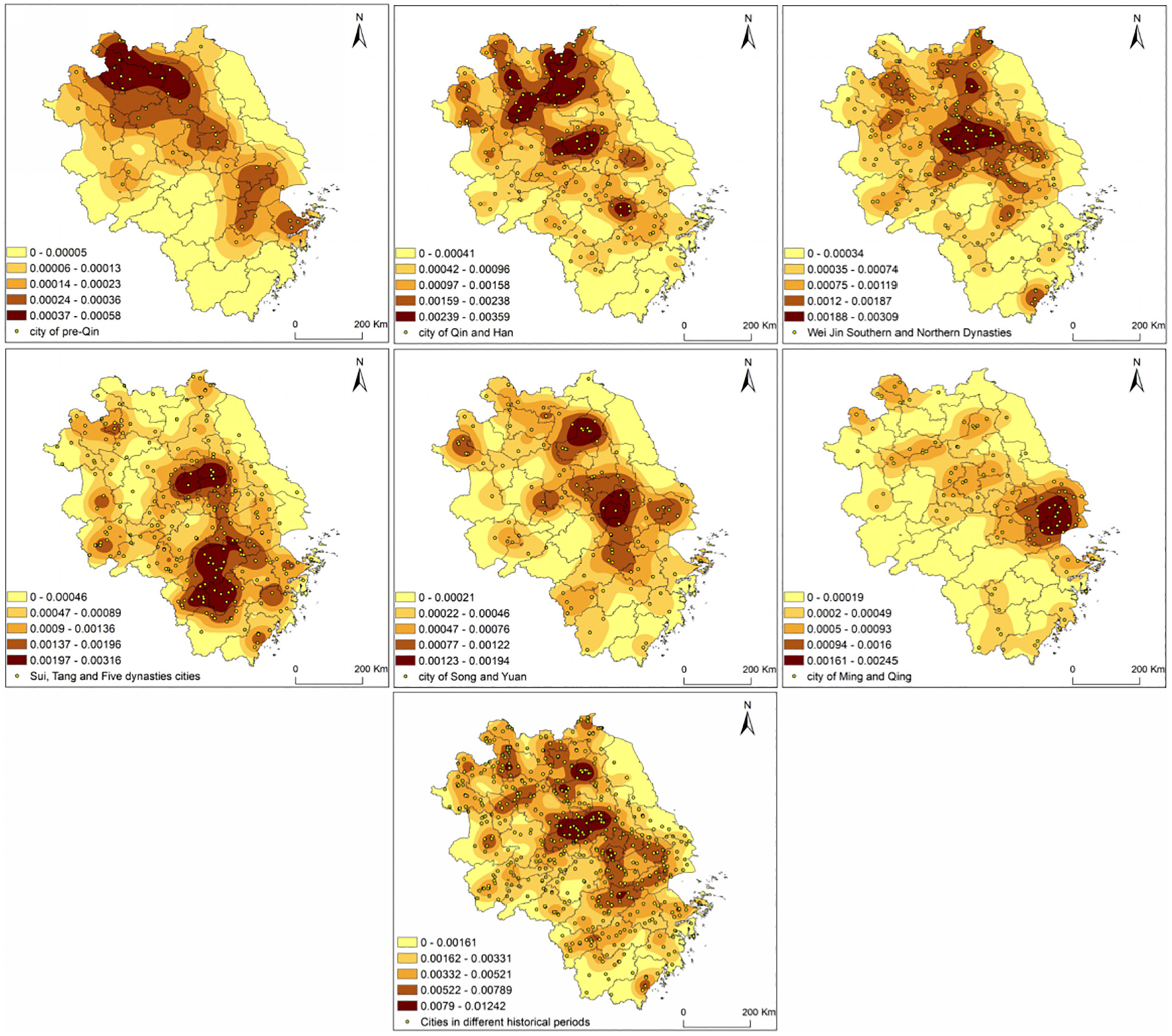
ArcGIS10.3 software was used to calculate the overall spatial density of national protection units in the Yangtze River Delta region and the spatial density pattern of national protection units in eight periods according to formula (2), as shown in Figure 1. On the whole, the national protection units in the Yangtze River Delta are distributed more in the south of the Yangtze River and less in the north of the Yangtze River. The spatial distribution characteristics of “three contiguous areas and two contiguous core areas” are formed, with Shanghai, Suzhou, and Wuxi as contiguous areas, Nanjing and Yangzhou as contiguous areas, Hangzhou and Shaoxing as contiguous areas, Ningbo as a single core area, and Huangshan as a single core area. In terms of individual provinces, the density of southern Jiangsu was higher than that of central and northern Zhejiang, the density of northern, eastern, and central Zhejiang was higher than that of southern and western Zhejiang, and the density of southern Anhui was higher than that of other regions. The core distribution areas of national protection units in the Yangtze River Delta region are mostly cities with a long history. There has been human activity since the Paleolithic. In history, it is also the economic center and political center of successive dynasties, creating a wealth of ancient sites, ancient buildings, modern and modern revolutionary sites, and other national key cultural relics protection types.

Nuclear density map of national key cultural relics protection units in different periods in the Yangtze River Delta region.
Prehistoric Times
In prehistoric times, national cultural relic protection units formed two core distribution areas (Figure 1). One was concentrated in Shanghai, Suzhou, Huzhou, Hangzhou, and Jiaxing regions where is the birthplace of Liangzhu civilization and Hemudu civilization around Taihu Lake. Second, it is concentrated in Xuzhou, Suzhou, and Huaibei where is the cultural area of the Huaihe River basin, with different prehistoric cultures such as Shishanzi culture, Dawenkou culture, and Longshan culture. From the nuclear density distribution map, we can see that the early civilization showed an obvious core-edge diffusion distribution characteristics (Tian et al., 2021), which also reflects that the Huaihe River region and the Yangtze River Delta region were important areas of ancient human life, and the derived Huaihe River basin civilization and the Yangtze River civilization constructed the common origin of the Chinese civilization.
Pre-Qin Period
In the pre-Qin period, national protection units formed contiguous high-density distribution areas with the core of southern Wuhu, northwestern Xuancheng, southern Nanjing, Zhenjiang, Changzhou, Wuxi, western Suzhou, Huzhou, western Hangzhou, and Shaoxing (Figure 1). Xuanwu Plain is located in the south of Wuhu and the northwest of Xuancheng city, where is suitable for the development of early agriculture. The ancient city sites, copper mine sites and mounds and tombs found in this area indicate that this area was an important political, economic and cultural center in southern Anhui from the Western Zhou Dynasty to the Spring and Autumn period (Zhi, 2005). In the late Shang and early Zhou dynasties, Taibo and Zhong Yong moved south from Shanxi to Meili in the south of the Yangtze River and established Gou Wu, which was centered in Suzhou, Wuxi, Changzhou and Danyang of Zhenjiang and radiated to Nanjing and Taihu basin (An & Shen, 2006). Shaoxing is the birthplace of the Yue nation (Ding et al., 2016), with ancient and profound cultural characteristics. During the pre-Qin and Spring and Autumn periods, the capital of the State of Yue was located in Shan-yin (now Shaoxing), and the urban density in this region gradually increased (Figure 2). As a conjugated area of Wuyue culture (W. R. Zhang & Song, 2018), Huzhou also formed a high-density area of national protection units.
Nuclear density map of city in different periods in the Yangtze River Delta region.
Qin and Han Dynasties
During the Qin and Han Dynasties, the number of national protection units in the Yangtze River Delta was small, with a total of 22, mostly for ancient tombs. Two core distribution areas are formed (Figure 1). One is concentrated in the junction area of Hangzhou, Shaoxing, Jiaxing and Ningbo, and the other is concentrated in Xuzhou, Suzhou, Huaian, and Lianyungang, where are also high-density urban development areas (Figure 2). The country was unified in the Qin Dynasty, Shaoxing region was set up as Kuaiji County. At the same time, the city of Hangzhou emerged with a relatively high social and economic level and a prosperous culture (G. C. Chen & Xi, 2000). Xuzhou, Suzhou, Huaian, and Lianyungang are the origin areas of Chu-Han culture (An & Shen, 2006). During the Han Dynasty, most of these areas were vassal states of the Han Dynasty and produced a large number of ancient tombs, thus forming a high-density core area.
Wei Jin Southern and Northern Dynasties
During the period of Wei, Jin, Southern and Northern Dynasties, the frequency of historical dynasties changing was fast, and the number of National Cultural Relics protection units in this period was the least. Nanjing was the capital of the six dynasties of Sun Wu, Eastern Jin, Southern Song, Southern Qi, Southern Liang, and Southern Chen. As a densely populated area during the Six Dynasties, the development of painting, calligraphy, tomb stone carving, and other technologies reached a climax, creating the present-day high-density core area of cultural relics protection units (Figure 1), and the high-density area of the city is formed with Nanjing as the center.
In the Eastern Jin and Southern Dynasties (Figure 2), people migrated from the north to the south, bringing advanced production technologies and tools, and large-scale development promoted the rapid economic and social development in the South of the Yangtze River (Hu, 2012), forming a sub-high-density area of national security units between Suzhou, Wuxi, Changzhou, and Zhenjiang. In addition, the integration of the Central Plains culture and the local culture of Zhejiang brought about by the southward migration of population also created the sub-high-density areas in Shaoxing and Lishui (L. Wu & Yu, 2021).
Sui, Tang, and Five Dynasties
In the Sui, Tang, and Five Dynasties, with the development of the Tang Empire, the society was prosperous and the national power was strong, and the number of National Cultural Relics protection units increased compared with that in the Wei, Jin, and Southern and Northern Dynasties. During this period, Buddhism gradually flourished, and grotto temples and stone carvings were widely distributed among Nanjing, Yangzhou, Suzhou, Wuxi, Hangzhou, Ningbo, Taizhou, Jinhua, Huangshan, and other regions in the Yangtze River Delta region (Figure 1), and more cities emerged in this region (Figure 2). In addition, during the SUI Dynasty, Hangzhou was the starting and ending point of the Grand Canal, and it was an important transportation hub in the lower reaches of the QiANTang River. During the Tang Dynasty, Hangzhou was an important source of tax revenue for the court, and during the Five Dynasties, the capital of the State of Wu Yue was established in Hangzhou. It can be seen that Hangzhou has always been an important economic, cultural and administrative center during the Sui, Tang, and Five Dynasties, so the National Cultural Relics protection units in this period formed a high-density core area.
Song and Yuan Dynasties
In the Song and Yuan Dynasties, the national protection units were dominated by ancient buildings, forming double core areas centered on Suzhou and Hangzhou, and sub-core areas centered on Ningbo, Wenzhou, and Jinhua, which were concentrated in Zhejiang province as a whole (Figure 1). The main reason is that during this period, the economic center of feudal society continued to shift southward. Especially since the middle of the Northern Song Dynasty, Zhejiang, Shanghai, and the southern part of Jiangsu have witnessed a significant increase in population and the emergence of more cities (Figure 2). With the social and economic development, Zhejiang has became one of the most developed and affluent regions in the country (Ding et al., 2016). During the Southern Song Dynasty, Zhejiang became the political, economic and cultural center of the Southern Song Dynasty, and the level of urban development reached the peak (G. C. Chen & Xi, 2000), leaving behind many ancient buildings such as temples and towers. Ningbo has been an important port city since the Tang Dynasty. After the Southern Song Dynasty, Ningbo and Wenzhou gradually became important ports of departure of the “Maritime Silk Road” (J. Zhou et al., 2019). Jinhua is located in the thoroughfare of four provinces, so it is an important transportation hub and economic development with a large number of ancient buildings survived.
Ming and Qing Dynasties
During the Ming and Qing Dynasties, the national cultural relic protection units formed a high-density area centered on Huangshan, Nanjing and Yangzhou, Suzhou and Wuxi, and Jinhua and Quzhou (Figure 1). However, the high value of urban density occurred in Shanghai during this period (Figure 2). In the Ming and Qing Dynasties, Quzhou and Jinhua were important transportation hubs with rich cultural heritage, and the Sanfan rebellion in the early Qing Dynasty caused the people migrate to the west of Zhejiang province (Ni, 2021), Which gradually became the birthplace of Wuzhou culture, and a large number of ancestral temples and dwellings were preserved. Huangshan City is the ancient Huizhou, after the middle of the Ming Dynasty, the Hui-shang culture flourished and developed. Under the idea of “relocation to the land,” a large number of ancestral halls, residential houses, archways, and other ancient village buildings were left in ancient Huizhou city, which still play an economic role in tourism. Nanjing was the administrative center of the Ming Dynasty in the early Ming Dynasty, and has been the economic center and cultural center of the Ming and Qing Dynasties since then. In the Qing Dynasty, Yangzhou gradually developed into an economic center represented by salt merchants and a cultural center centered on Wei Yang culture, leaving behind a large number of ancient buildings such as salt merchants’ houses and gardens. In addition, Nanjing was opened as a treaty port after the Treaty of Nanjing in the late Qing Dynasty, leaving behind important historical relics and representative buildings in modern times.
Since Modern Times
Since modern times, the national cultural relics protection units have formed core areas centered on Shanghai, Nanjing, and Hangzhou respectively. Shanghai opened its port in modern times, and the exchange and collision with foreign cultures formed a unique Shanghai culture (B. H. Chen, 2000). Nanjing area was the political center and economic center of the Kuomintang period, with a large number of foreign embassies and the former sites of the national government units. Since modern times, Hangzhou has been an important economic and cultural center in Zhejiang province, with many former residences of famous people. At the same time, there are many revolutionary relics in Shanghai and Nanjing, which reflects the revolutionary movement carried out by the early Communist Party of China with Shanghai and Nanjing as the central cities.
Spatial Agglomeration Characteristics of National Protection Units in Different Historical Periods
In order to determine the overall and different historical distribution types of national protection units in the Yangtze River Delta, the nearest neighbor index is calculated in the Arcgis 10.3 software, and the results are shown in Table 3. It can be seen that in general, the values of r1, re are 7,040.71 and 12,537.84 m, so the nearest ratio of national protection units in the Yangtze River Delta region is 0.56, less than 1, showing a condensed state in spatial distribution, which is consistent with the existing spatial distribution results of national protection units in the Beijing-Tianjin-Hebei region (Yue & Dai, 2020), Yellow River basin (C. Zhou et al., 2021) and Hubei province (A. Q. Zhu et al., 2016). From prehistoric times to modern times, the average observation distance of cultural relic protection sites in different periods is less than the expected average distance, the nearest neighbor index is less than 1, and the spatial distribution is also in a state of spatial condensation. Specifically, the value of the nearest neighbor index increased from 0.79 to 0.92 from the prehistoric period to the Qin and Han Dynasties (Table 3), it reflects that the spatial agglomeration degree of cultural protection units has decreased. In Wei, Jin, Southern and Northern Dynasties, the nearest neighbor index decreased to 0.69, and the spatial agglomeration degree of national protection units strengthened. In the Sui, Tang, and Five dynasties, the nearest neighbor index increased to 0.80, and the spatial agglomeration degree of national protection units decreased. Subsequently, the nearest neighbor index of national security units decreased gradually from the Song and Yuan dynasties to the Ming and Qing Dynasties, reflecting the enhancement of the degree of spatial agglomeration. In modern times, the nearest neighbor index increased which reflects that the spatial agglomeration degree of cultural protection units decreases. The Z score is all negative (Table 3), which also indicates that the spatial aggregation degree of cultural preservation unit space in different historical periods is agglomerative.
Results of Spatial Structure Type.

The standard deviation ellipse was used to understand the spatial distribution evolution and center of gravity shift trajectory of national protection units in different historical periods through Arcgis10.3 software (Figure 3, Table 4). In prehistoric times, the center of national protection units was located in Liyang City, Changzhou City (119.346°E, 31.609°N); During the pre-Qin period, the center of national protection unit moved from south to west to Langxi County, Xuancheng City (119.263°E, 31.271°N), with an offset distance of 39.56 km. During the Qin and Han Dynasties, the center of national protection unit moved from north to west to Liuhe District in Nanjing (118.831°E, 32.559°N), with an offset distance of 174.74 km. In the period of Wei, Jin, Southern and Northern Dynasties, the national protection unit center returned to Langxi County in Xuancheng City (119.298°E, 31.203°N) from south to east, with an offset distance of 155.69 km. During the Sui, Tang, and Five Dynasties, the national protection unit center continued to move southward to Anji County, Huzhou City (119.696°E, 30.850°N), with an offset distance of 54.48 km. During the Song and Yuan dynasties, the national protection unit moved from south to east, still within the Yuhang District of Hangzhou (119.889°E, 30.439°N), with an offset distance of 41.26 km. During the Ming and Qing Dynasties, the national protection unit center returned to Anji County, Huzhou City (119.473°E, 30.532°N), with an offset distance of 41.48 km. Since modern times, the center of national protection unit moved to Yixing City of Wuxi City (119.771°E, 31.263°N), with an offset distance of 86.35 km. In different historical periods, the national protection units showed a trend of transfer from south west to north west to south east to south east to northwest to northeast.

Ellipse and center of the national standard deviation of the Yangtze River Delta in different historical periods.
Elliptic Parameters of Standard Deviation.

The azimuth angle of the national protection units in the eight periods ranged from 131.25° to 158.38°, indicating that the spatial distribution pattern of national protection units had the characteristics of northwest to southeast distribution. From the pre-history period to the Qin and Han dynasties, the major semi-axis increased from 274.72 to 334.19 km as presented in Table 4. It indicates that the spatial distribution becomes scattered gradually., The value of the major semi-axis in the Wei, Jin, Southern and Northern Dynasties, Sui, Tang, and Five Dynasties, Song and Yuan Dynasties is close to that of the Qin and Han dynasties, but the value of the major semi-axis is smaller than that of the Qin and Han dynasties, indicating that the spatial distribution has changed from dispersion to agglomeration. However, the minor semi-axis increased from 105.18 to 162.67 km in the three periods. It shows that the spatial distribution also shows a dispersed trend gradually. Since modern times, the values of the major and minor hemispheres have become smaller, indicating that the spatial distribution and agglomeration trend has increased. Generally speaking, the eight time stages show the evolution process of agglomeration—dispersion—agglomeration—dispersion—dispersion—agglomeration—agglomeration.
Discussion
Construction of Influencing Factor Index System
There is a close relationship between National key cultural relics protection units and human activities. The formation and spatial distribution of cultural relics protection units fully reflect the interaction between human and earth, and the distribution must be affected by the comprehensive natural factors and social and economic development. Previous studies have revealed that topography, water system distribution, climate change, economic development, population density, and economic level are important influencing factors of cultural relic protection sites (Tian et al., 2021; Xi et al., 2013; Xu & Zeng, 2021; Yang & Feng, 2016; Yi & Chen, 2021; Yue & Dai, 2020; J. C. Zhang et al., 2019; Z. R. Zhang et al., 2017; C. Zhou et al., 2021; A. Q. Zhu et al., 2016). In order to explore which factor greatly influence the spatial distribution of national cultural relic protection units in the Yangtze River Delta region. Two dimensions and 13 index are constructed base on the Availability of prior research and data in Table 5. For example, the current road traffic in China is mostly evolved on the basis of historical roads or post roads, which can be quantified by highway mileage. In addition, the GeoDetector software (J. F. Wang & Xu, 2017) was used to detect the impact of each index on the spatial distribution of national protection units in the Yangtze River Delta region through q value. The q values can be calculated through the GeoDetector software.
Influencing Factors and Explanatory Power of Spatial Distribution of National Security Units in the Yangtze River Delta.

Space Factor Detection
Analysis of Natural Environment Elements
The size of q value obtained by geographic detector (Table 5) shows that the constructed factors have different effects on the spatial distribution of national protection units in the Yangtze River Delta, and both the natural environment and the level of social and economic development have effects on the spatial distribution of national protection units. Among the natural environment elements, relief and drainage density have significant influence on the spatial distribution of cultural relic protection units with the q value is 0.636 and 0.695. Especially in Zhejiang province and Anhui province, there are many ancient buildings. These areas have higher altitude, relatively large terrain relief, and relatively complex terrain and poor accessibility compared with plain, which has a protective effect on the preservation of ancient buildings. According to the national basic landform classification standard (Li et al., 2008), the relief less than 30 m is regarded as plain and platform, the relief less than 200 m is regarded as hill, the relief between 200 and 500 m is regarded as small undulation mountain, and the relief between 500 and 1,000 m is regarded as medium undulation mountain. The method of mean of change-point analysis was used to determine the best analysis window for the relief degree of the Yangtze River Delta (Chang et al., 2014). The relief degree is shown in Figure 4. The statistical results show that 465 national key cultural relic protection units distribute in plain and platform, and 206 in hilly areas, accounting for 92.04% of the total. Taking 15 km as a buffer zone for rivers and lakes in the Yangtze River Delta region, we analyzed the number of national key cultural relic protection sites, a total of 683 data points were found accounting for 93.69% of the total. The Yangtze River, Huaihe River, Grand Canal, Xin’an River, Taihu Lake, Hongze Lake, and other river systems are densely interconnected in Yangtze river delta region. Cities are born and thrive because of the rivers, and human social and economic activities are mainly distributed along the banks of river systems. There are many national key cultural relics protection units derived from different historical stages, so the density of river network has a significant impact on the spatial distribution of national cultural relics protection units.

The correlation between national key cultural relics protection units and gemorphic index in Yangtze River Delta.
Analysis of Social Environment Elements
Among the socio-economic factors, the level of economic development, the abundance of A-level scenic area resources, the abundance of intangible cultural heritage resources and the total population have a significant impact on the spatial distribution of national protection units. Shanghai, Nanjing, Hangzhou, Suzhou, Xuzhou city have high level of economic development and population agglomeration in history, this bring a high spatial distribution density of national protection units. The prosperity of social economy will give rise to the emergence of carriers of cultural protection units, and will also bring about the richness of intangible cultural heritage. Therefore, the increase of the abundance of intangible cultural heritage resources will also promote the high density of national protection units. The amount of funds invested in cultural undertakings is of great significance to the protection and development of national protection units, and also affects the spatial distribution of national protection units. In addition, the cultural division of the Yangtze River Delta region was carried out according to the researches of existing scholars (Han et al., 2021; Li et al., 2008; Zeng, 2013; F. Zhang & Cui, 2007) (Figure 5), among which Shanghai is the Shanghai culture area; Zhejiang is divided into northern Zhejiang cultural area, eastern Zhejiang cultural area, southern Zhejiang cultural area and central Zhejiang cultural area. Jiangsu is divided into Jinling Cultural area, Wu Cultural area, Huaiyang Cultural area, Chuhan cultural area, and Haiyan Cultural area. The regions with a large number of national key cultural relic protection units in different cultural areas are taken as examples to analyze.

Different distribution of national key cultural relics protection units in different culture areas of Yangtze River Delta.
It can be seen from Figure 5 that the high density areas of different types of cultural relics are mainly concentrated in Shanghai School cultural district, The North Zhejiang cultural area and the middle Zhejiang cultural area in Zhejiang province, Jiangnan Cultural District in Anhui province, Jinling Cultural District, and Wu Cultural District in Jiangsu province. According to the analysis of number about key cultural relic protection units in different cultural areas. There are 123 national key cultural relics protection units in the north of Zhejiang cultural area with traditional dwellings and stone bridge typically in China (Zeng, 2013). In this area, the national key cultural relics protection units are mainly ancient buildings, and the distribution of ancient buildings has formed a high-density value area (Figure 5), meanwhile, as the origin of civilization in the Yangtze River Basin, this region also has a large distribution of ancient sites created by ancient civilizations such as Liangzhu civilization (Figure 5). There is a total of 95 national key cultural relics protection units in Jiangnan culture of Anhui area, the region which mainly refers to the mountains and the folk patriarchal concept is strong in the south of Anhui has formed the national well-known village culture, in addition, the development of this region was restricted by the traffic conditions in history, a large number of Hui-style residential buildings have been preserved. Therefore, the national key cultural relics protection units in this region are mainly ancient buildings, forming another high density area of the distribution of ancient buildings (Figure 5). There is a total of 89 national key cultural relics protection units in Wu Culture District. This area has been the economic and cultural center since the Song and Yuan Dynasties. The residential buildings, garden buildings and Buddhist buildings in the water town have been largely built and left behind. It is also a high-density area with spatial distribution of ancient buildings. There are 86 national key cultural relics protected units in the cultural area of central Zhejiang which are Influenced by the terrain conditions such as narrow valley corridors (Figure 4), this area played the role of cultural diffusion channel in the historical period, and was greatly influenced by Huizhou culture, with typical hilly folk culture characteristics. The national key cultural relics protected units are mainly ancient buildings. There is a total of 70 national key cultural relics protection units in Jinling district where is greatly influenced by political, therefore many ancient architecture and ancient site culture were left. Especially as the political center of the Kuomintang government, it produced many important historical relics and representative buildings in modern times (Figure 5).
There are 41 national key cultural relics under protection in Shanghai Cultural District where is characterized by openness, creativity, sublation, and diversity. As a port city in modern times, it has digested and absorbed western cultural elements, and is dominated by important historical sites and representative buildings in modern times (Figure 5). It should be pointed out that the urban spatial distribution density (Figure 2) of different historical periods since the spring and autumn period to the Qing dynasty have less impact on the spatial distribution of cultural relic protection units, the q value is 0.457 in Table 5. The reason may be that many small cities have a short development time since their establishment due to various factors, and it is difficult to support and produce many ancient buildings, ancient sites, and other national protection units in a short period of time.
Conclusion
National key cultural relics protection units are important carriers of cultural inheritance and tourism development. This study uses multiple quantitative analysis methods to study the spatial distribution characteristics and influencing factors of cultural relics preservation units in the Yangtze River Delta region, which is helpful to deepen the understanding of cultural relics and cultural preservation units in the Yangtze River Delta region from the perspective of time and space. Through the research, this paper draws the following conclusions.
First, the number of national cultural relic protection units gradually decreased from prehistoric times to Wei, Jin, Southern and Northern Dynasties, surged from Sui, Tang, and Five Dynasties to Song and Yuan Dynasties, reached a peak in Ming and Qing Dynasties, and declined slightly since modern times. However, in terms of the frequency of the number of national cultural relics protection units per hundred years, the number of national cultural relics protection units has been the largest since modern times.
Second, on the whole, the national cultural relics protection units have formed the spatial distribution characteristics of “three areas connected and two areas single core” with Shanghai, Suzhou and Wuxi as contiguous areas, Nanjing and Yangzhou as contiguous areas, Hangzhou and Shaoxing as contiguous areas, Ningbo as single core area and Huangshan as single core area. In terms of individual provinces, the distribution density in the south of Jiangsu province is higher than that in the central and northern regions, the distribution density in the north, east and central of Zhejiang province is higher than that in the south and western regions, and the distribution density in the south of Anhui province is higher than that in other regions.
Third, the nearest neighbor index value of national cultural relics protection units in the Yangtze River Delta region is 0.56, which indicates a cohesive state in spatial distribution. In different historical periods, the national protection units showed a transfer trend from southwest to northwest to southeast to southeast to northwest to northeast, showing an evolution process of agglomeration—dispersion—agglomeration—dispersion—dispersion—agglomeration—agglomeration.
Finally, the natural environment and the level of social and economic development have a comprehensive influence on the spatial distribution of national protection units. Among the natural environment elements, relief and river network density have significant effects on the spatial distribution of national protection units. Among the socio-economic factors, the level of economic development, the abundance of A-level scenic area resources, the abundance of intangible cultural heritage resources and the total population have a significant impact on the spatial distribution of national protection units. From Spring and Autumn period to Qing Dynasty, the urban spatial distribution density had a weak influence on the spatial distribution of national protection units in different historical periods.
The aim of this paper is to provide reference for the protection, development and activation of cultural protection units in the Yangtze River Delta region. Specifically, first, to establish a long triangle area of cultural relics protection unit of geographic information database, and display of cultural relics protection unit name, location, detailed address, category, protection level, and overall description and the Yangtze river delta area of cultural relics protection unit integral space pattern, achieve modernization cultural heritage information service and management functions, It provides comprehensive reference information for the protection and development of cultural relic protection units. Second, under the trend of increasingly innovative science and technology, it is necessary to strengthen the application of modern science and technology, and improve the investigation and detection ability, data analysis and integration ability of national protection units. With the help of big data, cloud computing, artificial intelligence and other technological means, more intelligent key cultural protection units will be protected and inherited. Such as the use of 3D images, virtual reality, augmented reality and other new technologies, to achieve text, images, audio, and video forms through the Internet, mobile terminals, and other platforms to fully display, expand the audience at home and abroad. Thirdly, under the influence of development history, cultural protection units in different historical periods in the Yangtze River Delta formed different agglomeration areas, and their distribution was affected by topography, landform, rivers, and other factors. Therefore, measures should be taken according to local conditions and time, and targeted protection strategies should be formulated by region and type. For the densely distributed areas of national protection units, the overall protection and utilization of national protection units can be carried out through the construction of archaeological site parks and national cultural parks. Unit of high density area, Yangtze river delta regional countries located in the economically underdeveloped areas, these areas in the process of cultural heritage protection and utilization to increase investment in cultural heritage protection fund, enhance the cultural heritage protection work of propaganda, attaches great importance to the introduction of cultural heritage protection management professionals, professional skills training to strengthen grass-roots staff. Fourthly, relying on the huge tourist market in the Yangtze River Delta region, combining the types of cultural protection units and the characteristics of spatial and temporal distribution, tourism products should be designed according to local conditions to create characteristic cultural experience routes, promote the activation of cultural relics, and realize the protection and development of cultural relics in the process of development.
Based on the method of spatial analysis and geographical detector, this study discusses the spatial and temporal distribution characteristics and influencing factors of the national key cultural relics protection units in different time stages in the Yangtze River Delta region, which is of great significance for understanding the cultural context of the Yangtze River Delta region and promoting the integration of different regional cultures. However, the factors affecting the spatial distribution of cultural protection units were often also affected by social unrest, climate change and population migration. For example, during the Taiping Heavenly Kingdom, Hangzhou Prefecture, Jiaxing Prefecture, and Huzhou Prefecture in northern Zhejiang province became one of the main battlefields between the Taiping Army and the Qing Army. The spatial distribution density of cultural protection units in this region was low in the Ming and Qing Dynasties, which may have been damaged by wars to a large extent. In addition, when discussing the influencing factors of the spatial distribution of cultural security units, this study adopts the method of “comparing the present to the ancient,” which has a certain one-sidedness. In the future, more attention should be paid to the collection of historical records, and the mechanism of multi-factors such as culture should be deeply explored by means of interdisciplinary and multi-field cooperation.
Footnotes
Declaration of Conflicting Interests
The author declared no potential conflicts of interest with respect to the research, authorship, and/or publication of this article.
Funding
The author received no financial support for the research, authorship, and/or publication of this article.
Data Availability Statement
The datasets generated during and/or analyzed during the current study are available from the corresponding author on reasonable request.