
Abstract
The digitalization of urban mechanisms relies on the integration of digital terrain and 3D city models. However, a systematic examination of this topic within the context of integrated smart cities or digital twins has been lacking, hindering reproducibility and interpretation of results. To address this gap, this study conducts a systematic literature review to explore the role of digital terrain and 3D city models in supporting urban decision-making for integrated smart cities or digital twins. By following a review protocol, research questions were formulated, and systematic search strategies were implemented involving reputable databases such as Scopus, Web of Science, Science Direct, Emerald, Taylor Francis, Springer Link, and Sage Journals. The review process included identification, screening, eligibility assessment, quality appraisal, data extraction, and thematic analysis. The thematic analysis identified eight main themes and 22 sub-themes, shedding light on various aspects of digital terrain and 3D city models in urban decision-making, including (1) data integration and interoperability, (2) integrated visualization; (3) environmental simulation; (4) digital twins application; (5) smart cities application; (6) semantic enrichment; (7) applied planning; and (8) urban planning. This systematic review identifies gaps in the field and provides directions for future studies.
Plain Language Summary
This study addresses the digitalization of urban mechanisms and its reliance on the integration of digital terrain and 3D city models, particularly within the context of integrated smart cities or digital twins. Despite its significance, a systematic examination of this topic has been lacking, leading to challenges in reproducibility and interpretation of research findings. To bridge this gap, the study conducts a systematic literature review to explore the role of digital terrain and 3D city models in supporting urban decision-making. Following a rigorous review protocol, the study formulates research questions and implements systematic search strategies involving reputable databases. Key databases like Scopus, Web of Science, Science Direct, Emerald, Taylor Francis, Springer Link, and Sage Journals are used for comprehensive coverage. The review process includes stages such as identification, screening, eligibility assessment, quality appraisal, data extraction, and thematic analysis. The thematic analysis reveals eight main themes and 22 sub-themes, shedding light on various aspects of digital terrain and 3D city models in urban decision-making. These themes encompass data integration and interoperability, integrated visualization, environmental simulation, digital twins application, smart cities application, semantic enrichment, applied planning, and urban planning. The systematic review not only contributes to a better understanding of the role of digital terrain and 3D city models in urban decision-making but also identifies gaps in the field. By providing directions for future research, this study aims to enhance the development and application of integrated smart cities and digital twins, ultimately contributing to more effective and sustainable urban planning and management.
Introduction
Urbanization is a rapidly progressing global phenomenon, with millions of people moving from rural to urban areas in search of better living conditions and job opportunities. The United Nations predicts that by 2050, more than 60% of the world’s population, or 6.5 billion people, will reside in cities (Attaran et al., 2022). This rapid urban population growth poses significant challenges, straining existing cities and increasing demand for services, housing shortages, and environmental concerns (Panteli et al., 2020; Shahidehpour et al., 2018). As a result, stakeholders and individuals consistently experience negative consequences.
In response to these challenges, the concept of integrated smart cities or digital twins has emerged, driven by the economic importance of cities, the need for more sustainable lifestyles, and technological advancements (Cheng et al., 2022; Nathali et al., 2018). For example, natural disasters like floods have highlighted the technological gaps between cities and nations, leading to social, economic, and health crises. To address these issues, governments must improve sustainable communication and smart city capabilities (Hoang & Nguyen, 2021). By integrating technology, administration, and leadership with a conducive living environment, cities can better mitigate the destructive consequences of such crises (Kunzmann, 2020).
To support stakeholders and decision-makers in exploring the urban environment, the authenticity of digital models, specifically 3D city models (3DCMs) and digital terrain, is crucial (Yan et al., 2019; Zeleňáková et al., 2019). These models provide comprehensive representations of buildings, zones, and cities, offering enhanced options for city analytics, decision-making, and community involvement (Schindler et al., 2020; Zhang et al., 2021). The development of 3DCMs has rapidly progressed in recent decades, utilizing various data sources such as terrestrial laser scans, 2D Geographic Information System (GIS) data, UAV images, and airborne laser scanning data (Biljecki et al., 2017; Hassan & Abdul Rahman, 2021; Jovanović et al., 2020). However, integrating digital terrain, including the ground’s elevation data, with 3DCMs remains a critical aspect that enhances the accurate representation of smart cities or digital twins, particularly in hilly areas (Yan et al., 2019).
While the benefits of digital terrain and 3DCMs in digital applications are extensive, further efforts are needed to understand their roles in implementing smart cities or digital twins models. This understanding is crucial for enhancing decision-making processes among stakeholders and improving urban planning. However, a comprehensive review of the research on integrating digital terrain and 3DCMs in this context has not been conducted. This study aims to fill this gap by conducting a systematic literature review (SLR) that synthesizes and analyzes relevant research on the role of digital terrain and 3DCMs in developing smart cities or digital twins and their impact on the decision-making process. The review will draw on articles from reputable databases, including Taylor Francis, Science Direct, Emerald, Sage Journals, Springer Link, Scopus, and Web of Science (WoS). By adopting an integrative review analysis approach, combining mixed quantitative and qualitative methodologies, this study aims to provide an organized and comprehensive understanding of the roles of digital terrain and 3DCMs in integrated modeling for smart cities or digital twins, contributing to the existing body of knowledge in this field.
Analytical Frameworks
In the realm of smart cities and digital twins, there is a lack of in-depth analysis and identification of trends in existing research. Traditional literature review methods can introduce bias and transparency issues, making it difficult for subsequent researchers to replicate or evaluate the studies thoroughly. Typically, many authors select publications supporting their findings (Shaffril et al., 2021). To address this gap, the current study adopts a SLR approach, focusing specifically on the role of digital terrain and 3DCM in supporting decision-making for integrated smart cities or digital twins. The analytical framework depicted in Figure 1 guides the review process, allowing the authors to identify research gaps and provide directions for future studies.
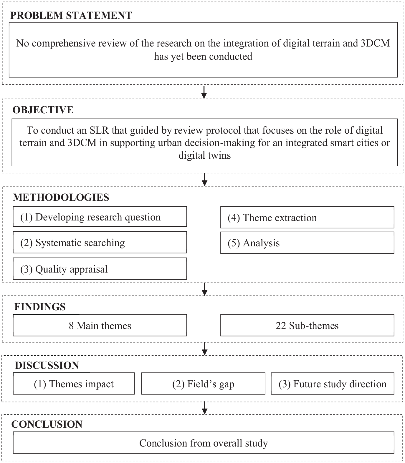
Analytical framework of this study.
The primary research question guiding this study is: What is the role of digital terrain and 3DCM in supporting decision-making for integrated smart cities or digital twins? The study highlights the crucial impact of digital terrain and 3DCM in enhancing the development and utilization of integrated smart cities or digital twins. By conducting a SLR, this study aims to uncover empirical evidence and shed light on the critical role of digital terrain and 3DCM in supporting decision-making processes for integrated smart cities or digital twins. This knowledge will contribute to advancing the field and guiding future research endeavors.
Methodology
The Reporting on the Systematic Evidence Syntheses (ROSES) review protocol guided the study’s current methodology. ROSES is a set of guidelines for systematic review and analysis in environmental management (Haddaway et al., 2018). ROSES is designed to encourage researchers to provide the right information with the right amount of detail. Where appropriate, the authors considered alternatives to the proposals made in the review to certify that the review process fulfilled the review’s goal.
Developing the Research Question
Two sources were used to formulate the research question: first, concepts from prior studies such as Buyukdemircioglu and Kocaman (2020), Rong et al. (2020), and Shirinyan and Petrova-Antonova (2022). Every article was related to the digital terrain and 3DCM, and urban decision-making for smart cities or digital twins. Second, recognize the acronym PICo, which stands for “P” for “Population or Problem,”“I” for “Interest,” and “Co” for “Context” (Lockwood et al., 2015). Based on these principles, the authors addressed three major components in their review: integration of 3D model and digital terrain (Problem), contribution (Interest), and integrated smart cities or digital twins (Context). It thus allowed the authors to establish the study’s major research question: What are the digital terrain and 3D City Model (3DCM) role in supporting urban decision-making for integrated smart cities or digital twins?
Systematic Searching Techniques
Shaffril et al. (2018) proposed three systematic techniques, including identification, screening, and eligibility, which were applied to extract the relevant articles. These techniques enabled the authors to discover and synthesize the research to organize and conduct an SLR transparently.
Identification
a. The identification was conducted to find more related articles for the review.
b. The authors consider synonyms, similar concepts, and variations of major keywords.
c. Four primary keywords were identified based on research questions: 3D model, terrain, integration, and smart cities.
d. Additional keywords and variations were searched using an online thesaurus (e.g., thesaurus.com), adapted from previous studies, compared to Scopus’s suggested keywords, and consulted with experts.
e. Keywords include 3D visualization, 3D object, Building Information Modeling (BIM), terrain intersection curve, Digital Terrain Model (DTM), landform, and digital twin.
f. Search methods: Used field code queries, phrase identification, truncation, wildcards, and Boolean operators in Scopus and WoS databases (see Table 1) and also by a manual search conducted in Taylor Francis, Science Direct, Emerald, Sage Journals, and Springer Link databases.
g. Article context specified: (1) Different applications of digital terrain and 3D models require varied preparatory approaches, and (2) the study focuses on the implications of urban decision-making for integrated smart cities or digital twins.
h. The number of potential articles discovered: 12,147.
The String Used for the Selected Database.

Screening
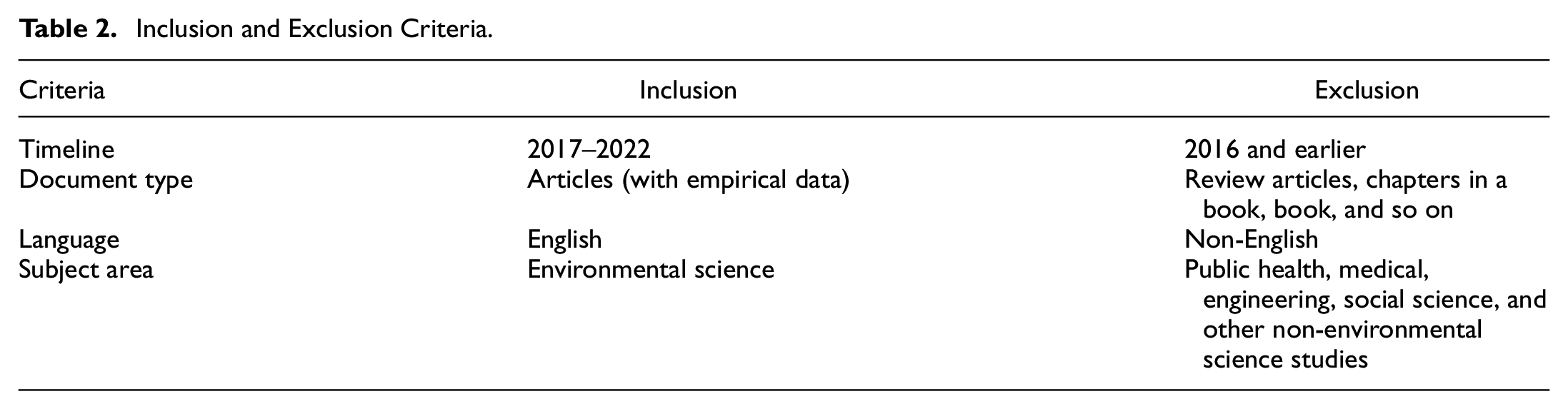
a. The screening was conducted using a combination of database search and manual evaluation by the authors based on requirements (refer to Table 2).
b. The screening process focused on articles published between 2017 and 2022, in line with the concept of relevant research sophistication emphasized by Kraus et al. (2020). This period was chosen because it provided sufficient published papers for a representative review.
c. Only factual research articles containing primary data were considered for review.
d. The evaluation was limited to English-written research articles to minimize misunderstandings.
e. To enhance the interdisciplinary approach to studying environmental systems, research publications from environmental science were included as benchmarks to identify additional relevant articles.
f. A total of 9,499 articles were excluded during the screening phase for not meeting the study’s requirements.
g. This resulted in 2,648 articles remaining for evaluation in the next round.
Inclusion and Exclusion Criteria.
Eligibility
a. The authors conducted the eligibility process and manually reviewed papers to determine if the articles met the inclusion criteria.
b. In the title screening stage, 2,384 articles were excluded.
c. In the abstract screening stage, 189 articles were excluded.
d. After reading the substance of the selected articles, 50 more were discarded.
e. During this stage, three articles were eliminated because the articles did not focus on digital terrain and 3DCM for urban decision-making. Instead, the articles referred to non-environmental science-based fields.
f. A total of 22 articles were accepted for the quality assessment stage (see Figure 2).

A flow chart of how searching works.
Quality Appraisal
A quality appraisal stage was conducted to ensure the accuracy and reliability of the reviewed studies. The Mixed-Method Appraisal Tool (MMAT), recommended by Hong et al. (2018), was employed for this purpose. The MMAT is useful for assessing different types of studies, including qualitative, quantitative, mixed-method, randomized controlled trials, and non-randomized studies (Table 3). The selected papers underwent two screening stages before undergoing quality assessment. The quality evaluation focused on specific criteria based on the research design. It helped address differences and discrepancies in research designs to ensure methodological and analytic quality. Using the MMAT, this study ensured that the reviewed studies met rigorous quality standards and provided reliable insights for the systematic literature review (Table 4).
The Criteria Used to Evaluate the Methodological and Analytical Rigor of the Selected Articles (Shaffril et al., 2018).

Quality Assessment Results.

Note. QA = quality assessment; QN = quantitative; QL = qualitative; MX = mixed-method; C = can’t tell.
Extraction and Analysis of Data
In this study, the authors analyzed different research designs to uncover meaningful patterns and connections. The authors followed a flexible approach Flemming et al. (2019) proposed for synthesizing data from various study designs. Thematic analysis, guided by Kiger and Varpio (2020), was used to identify patterns in existing research.
The authors began by thoroughly reading and understanding the complete dataset, gaining important insights. The authors then organized the data into detailed codes and extracted relevant information about their research question. Based on these codes, themes representing the entire dataset were identified using an inductive coding framework. Through this process, the authors discovered eight major themes and explored each to identify potential sub-themes, resulting in 22 sub-themes. To ensure the validity of their findings, the authors consulted experts in qualitative synthesis and the environmental field, who validated the themes and sub-themes. This systematic analysis provides valuable insights into the research area, offering a comprehensive understanding of the patterns and connections within the data.
Results
Background of the Selected Studies
Based on the final 22 articles, a total of three papers focused their studies in Bulgaria (Dimitrov & Petrova-Antonova, 2021; Petrova-Antonova & Spasov, 2021; Shirinyan & Petrova-Antonova, 2022), two in China (Pan et al., 2020; Rong et al., 2020) and two in Turkey (Buyukdemircioglu & Kocaman, 2020; Guntel & Aydinoglu, 2021). The following papers only involve one study location, including Colombia (Alomía et al., 2021), France (Delval et al., 2021), Netherlands (Biljecki et al., 2017), Russia (Sharma et al., 2021), Germany (Braun et al., 2018), United Kingdom (Wang et al., 2018), Switzerland (Schrotter & Hürzeler, 2020), Australia (Yan et al., 2019), and other seven are without focusing on the specific location (Clemen et al., 2021; Lafioune & St-Jacques, 2020; Lau et al., 2019; Lee et al., 2020; Li et al., 2022; Moon et al., 2019; Xie et al., 2020) as shown in Figure 3.

Countries in which the undertaken studies.
It was identified that 11 studies are focused on qualitative analyses (Alomía et al., 2021; Buyukdemircioglu & Kocaman, 2020; Clemen et al., 2021; Dimitrov & Petrova-Antonova, 2021; Guntel & Aydinoglu, 2021; Lafioune & St-Jacques, 2020; Lau et al., 2019; Lee et al., 2020; Petrova-Antonova & Spasov, 2021; Schrotter & Hürzeler, 2020; Yan et al., 2019), eight on the quantitative analyses (Biljecki et al., 2017; Delval et al., 2021; Li et al., 2022; Moon et al., 2019; Rong et al., 2020; Sharma et al., 2021; Wang et al., 2018; Xie et al., 2020), and three are focused on the mixed-method approach (Braun et al., 2018; Pan et al., 2020; Shirinyan & Petrova-Antonova, 2022) as shown in Figure 4.

Research design of the undertaken studies.
Regarding the year of publication, one article was published in the year 2017 (Biljecki et al., 2017), two articles were published in the year 2018 (Braun et al., 2018; Wang et al., 2018), three articles were published in the year 2019 (Lau et al., 2019; Moon et al., 2019; Yan et al., 2019), seven articles were published in the year 2020 (Buyukdemircioglu & Kocaman, 2020; Lafioune & St-Jacques, 2020; Lee et al., 2020; Pan et al., 2020; Rong et al., 2020; Schrotter & Hürzeler, 2020; Xie et al., 2020), seven articles were published in the year 2021 (Alomía et al., 2021; Clemen et al., 2021; Delval et al., 2021; Dimitrov & Petrova-Antonova, 2021; Guntel & Aydinoglu, 2021; Petrova-Antonova & Spasov, 2021; Sharma et al., 2021), and two articles were published in the year 2022 (Li et al., 2022; Shirinyan & Petrova-Antonova, 2022) as shown in Figure 5.

Publication year of the undertaken studies.
The review discovered that five articles were published in the International Society for Photogrammetry and Remote Sensing (ISPRS) (Clemen et al., 2021; Dimitrov & Guntel & Aydinoglu, 2021; Petrova-Antonova, 2021; Shirinyan & Petrova-Antonova, 2022; Yan et al., 2019), two articles were published in the Institute of Electrical and Electronics Engineers (IEEE) (Braun et al., 2018; Lee et al., 2020), one article were published in the Virtual Reality and Intelligent Hardware Journal (VRIH) (Alomía et al., 2021). The following publications, however, only published one article, which is International Conference on Computational Science and Its Applications (ICCSA) (Petrova-Antonova & Spasov, 2021), Automation in Construction (AIC) (Moon et al., 2019), Landscape and Urban Planning (LUP) (Li et al., 2022), Computers, Environment and Urban Systems (CEUS) (Biljecki et al., 2017), Environmental Modelling and Software (EMS) (Wang et al., 2018), Information Fusion (IF) (Lau et al., 2019), Innovation and Management Review (IMR) (Lafioune & St-Jacques, 2020), Journal of Hydrology (JH) (Rong et al., 2020), Journal of Photogrammetry Remote Sensing and Geoinformation Science (JPRSGS) (Schrotter & Hürzeler, 2020), International Conference on Computing in Civil and Building Engineering (ICCCBE) (Delval et al., 2021), Quaternary International (QI) (Sharma et al., 2021), Remote Sensing (RS) (Buyukdemircioglu & Kocaman, 2020), Tunnelling and Underground Space Technology (TUST) (Pan et al., 2020), Robotics and Autonomous Systems (RAS) (Xie et al., 2020). All selected articles had good quality, as both Scopus and WoS databases indexed the articles. Most were ranked either in Quartile 1 or 2—as shown in Table 5.
Selected Journals Ranking.

Source. Scopus (2022), Web of Science (2022).
The Developed Themes
Eight main themes emerged from the thematic analysis of 22 selected articles: (1) data integration and interoperability, (2) integrated visualization; (3) environmental simulation; (4) digital twins application; (5) smart cities application; (6) semantic enrichment; (7) applied planning; and (8) urban planning. These eight themes generated an additional 22 sub-themes (see Table 6). Based on the findings, the primary research question of this SLR, “What are the digital terrain and 3DCM role in supporting urban decision-making for integrated smart cities or digital twin?” was addressed by these eight themes and 22 sub-themes. The subsequent section provides background information about the selected studies.
Themes and Sub-Themes Findings.

Data Integration and Interoperability
The first sub-theme of data integration and interoperability concerns the foundation of a digital city. Rong et al. (2020) integrated 3DCM with high-resolution topographic DEM data for flood inundation simulation in Weihai City, China. BIM represented the 3DCM, while the GIS model served as the foundation for the digital city model. A comparison was made between 2D and 3D hydrodynamic models, demonstrating that a 3D foundation yields more precise and realistic results. Similarly, Clemen et al. (2021) emphasized the integration of BIM with DTM for the foundation of digital twins. They developed the IfcTerrain tool to facilitate integrating different data formats. Dimitrov and Petrova-Antonova (2021) adopted a Level of Detail 1 (LoD1) 3DCM model and DEM as the terrain base for their study in Sofia City, Bulgaria. They discussed the challenges of interpolating buildings’ footprints with DEM due to data accuracy gaps. Shirinyan and Petrova-Antonova (2022) implemented the LoD1 3DCM model and DEM for digital city development, focusing on technical aspects such as terrain intersection curves, geometry features, and attributes. These studies demonstrate the adoption of 3DCM and digital terrain as the foundation for digital cities.
Multidimensional interoperability is another sub-theme within data integration and interoperability. Guntel and Aydinoglu (2021) developed a 3D database that integrates topographic data, 3DCM, and cadastre information to support integrated smart cities visualization and query functions in Amasya, Turkey. Yan et al. (2019) discussed the integration of 2D building footprints and 2.5D digital terrain, highlighting multidimensional concepts and various integration approaches. Lau et al. (2019) proposed a multi-perspective classification for assessing smart city applications, emphasizing the use of diverse data sources. These studies showcase the use of 3DCM and digital terrain for multidimensional interoperability, supporting the development of integrated smart cities and digital twins. The third sub-theme of data integration and interoperability is data fusion bases. Delval et al. (2021) combined different datasets and parameters to assess the urban comfort and usability of public areas. Braun et al. (2018) used digital terrain and 3DCM as a basis for data fusion to improve the match between simulated and observed data. Moon et al. (2019) fused hybrid point clouds and digital terrain to enhance the 3D world model for equipment planning. These studies demonstrate the application of digital terrain and 3DCM as data fusion bases, allowing for managing multiple data sources and enhancing simulation results.
The fourth sub-theme of data integration and interoperability is analytical input. Li et al. (2022) highlighted the role of digital terrain and 3DCM in city information modeling, suggesting integration with GIS for improved quality and automation. Wang et al. (2018) emphasized the identification of different thresholds for modifying digital terrain elevations to effectively analyze urban micro-features like buildings and underpasses in flood modeling. Pan et al. (2020) utilized the digital terrain and 3D underground models to enhance the precision of 3D geological simulations. Sharma et al. (2021) recommended incorporating terrain parameters as analytical input for environmental analysis. These studies illustrate the involvement of digital terrain and 3DCM as analytical input, supporting urban and environmental decision-making. In conclusion, the studies emphasize the importance of the sub-themes in showcasing the diverse applications of 3DCM and digital terrain in supporting integrated smart cities and enhancing decision-making processes.
Integrated Visualization
The first sub-theme within the integrated visualization theme focuses on temporal visualization. This review discovered that digital terrain and 3DCM had extended their role in supporting decision-making for integrated smart cities and digital twins. This extension includes integrated and temporal visualization, which are significant in applying smart cities and digital twins. By employing temporal visualization, stakeholders can visualize the changes within a city and gain insights for future planning. Buyukdemircioglu and Kocaman (2020) integrated a future city model (Level of Detail 3 (LoD3)) and a representation of current urban structures (Level of Detail 2 (LoD2)) with a high-resolution DTM as the base data while exploring performance-tuning techniques such as web-based visualization. In contrast, Lee et al. (2020) focused on visualizing past city and road conditions using temporal visualization. Their work demonstrated the feasibility of recreating historical movable dynamic data within a digital twin-temporal visualization application. Thus, this sub-theme showcases how digital terrain and 3DCM have enhanced spatial visualization for urban and environmental decision-making.
The second sub-theme within the integrated visualization theme centers on representing vertical variation. Digital terrain and 3DCM serve as the foundation for representing vertical variation, particularly when combined with dynamic simulation and other multidimensional aspects. Lafioune and St-Jacques (2020) explained that data digitization and technology integration advancements enabled 3D smart city models that utilize digital terrain and 3DCM to provide searchable city information. This approach surpasses the limitations of 2D visualization and allows for the inclusion of additional information, especially regarding high buildings. Moreover, three-dimensional geological models that employ digital terrain as a base and the fundamental 3D data model help represent vertical variation (Pan et al., 2020). Pan et al. (2020) further discuss how reworking 3D geological formations and efficiently storing vast amounts of 3D data within a digital model, particularly representing volume information, can establish a robust foundation for urban decision-making. Rong et al. (2020) studied 3D urban flood inundation simulation, highlighting the failure of 2D hydrodynamic assumptions and approximations in urban areas with significant vertical fluctuations. This reinforces the crucial role of digital terrain and 3DCM in representing vertical variation within integrated smart cities and digital twin environments. Therefore, this sub-theme illustrates how research has leveraged digital terrain and 3DCM to enhance the representation of vertical variation.
The third sub-theme within the integrated visualization theme focuses on multidimensional visualization. This review indicates that digital terrain and 3DCM support decision-making for integrated smart cities and digital twins by enabling multidimensional visualization. The concept of multidimensionality necessitates a platform capable of projecting multidimensional visualization output (Nonato & Aupetit, 2019), which has sparked interest among software developers. For instance, Shirinyan and Petrova-Antonova (2022) enhanced multidimensional visualization through the ArcGIS Pro platform in their study, visualizing the components of 3DCM and digital terrains. Petrova-Antonova and Spasov (2021) explored web-based applications using Cesium Ion to visualize multidimensional components. These applications aid stakeholders in visualizing integrated data and facilitating the decision-making process for smart cities and digital twins. Visualizing multidimensional components allows issues related to component integration to be easily identified, leading to proposed solutions. Clemen et al. (2021) proposed IfcTerrain, a tool addressing terrain model issues compliant with BIM. Clemen et al. (2021) emphasize that digital terrain and 3DCM are core factors that contribute to precise modeling. Thus, the proposed solution through tools becomes the focal point of their study. Xie et al. (2020) focused on combining multidimensional components such as mobile laser scanner (MLS) data and building facet modeling. These components serve as a midpoint to expand the MLS point cloud into digital terrain and 3DCM. These are crucial for developing integrated smart cities or digital twins with multidimensional visualization capabilities. This sub-theme underscores how specific research has utilized digital terrain and 3DCM to meet the requirements of multidimensional visualization for urban and environmental decision-making. Overall, the review reveals that these technologies have extended their role in various sub-themes, ultimately contributing to urban and environmental decision-making in the context of integrated smart cities and digital twins.
Environmental Simulation
The first sub-theme in the field of environmental simulation focuses on physical simulation. One important application of digital terrain and 3DCM is their use as inputs for physical simulation, supporting decision-making in integrated smart cities and digital twin systems. Notably, Alomía et al. (2021) proposed a new method to generate accurate urban model approximations by incorporating various urban infrastructure and transportation networks. To simulate the operability of these approximations, the researchers integrated DTM, digital surface models (DSM), and 3DCM and employed vehicle and crowd simulation techniques (Alomía et al., 2021). Similarly, Braun et al. (2018) conducted building heating simulations, adjusting the digital terrain and 3DCM to accommodate slope conditions and replicate real-world scenarios. The accuracy of the 3D models was emphasized in this study, as high-quality 3D models yield precise results in heating demand simulations (Braun et al., 2018). Moreover, some articles employed digital terrain and 3DCM for flood modeling simulations. For instance, Wang et al. (2018) focused on high-resolution urban flood modeling, highlighting the need to separate critical urban features from topographic data to capture detailed flood mechanisms. In another study on urban flood inundation simulation, Rong et al. (2020) utilized the digital city model and DTM, demonstrating that accurate flood simulations require precise topographic data (Rong et al., 2020).
The second sub-theme in the realm of environmental simulation explores dynamic simulation in addition to serving as inputs for physical simulations, digital terrain, and 3DCM support urban decision-making through dynamic simulation applications. Delval et al. (2021) conducted a study incorporating dynamic simulation, digital terrain, and 3DCM through BIM. Their research focused on multiscale simulations, including noise, wind, and thermo-aeraulic aspects. For noise simulation, the researchers integrated digital terrain and 3DCM information with traffic evolution data to obtain noise level data for road and railway areas. Additionally, wind simulation was performed by integrating climate database, environmental information, digital terrain, and 3DCM data. Lastly, the study employed physiological equivalent temperature (PET) coding to rate all activities based on comfort levels. Finally, the thermo-aeraulic simulation facilitated an energy balance analysis between the human body and the external environment (Delval et al., 2021). Based on their findings, Delval et al. (2021) highlighted the challenge of incorporating structures and digital terrain surfaces into a single model and determining appropriate intersections, which required solving geometric specifications. The 3DCM faced additional constraints during this process, such as ensuring watertight ground and buildings without self-intersecting lines. These insights emphasize the crucial role of digital terrain and 3DCM in dynamic simulation. In conclusion, the first and second sub-theme reveals that digital terrain and 3DCM are crucial inputs in environmental simulation, enhancing outcomes and enabling informed urban and environmental decision-making.
Digital Twins Application
The first sub-theme in the digital twins’ application theme focuses on dynamic applications. This role involves utilizing digital terrain and 3DCM to aid urban decision-making for digital twins. Several studies have embraced this concept. For instance, Alomía et al. (2021) employed digital terrain and 3DCM as a foundation to track dynamic data related to people, vehicles, and municipal activities. The dynamic application produces crucial outputs that enable the integration of established urban structures into digital twins, thereby facilitating urban decision-making. Similarly, Dimitrov and Petrova-Antonova (2021) emphasized the importance of incorporating digital terrain and 3DCM in constructing digital city twins, allowing for the representation of the city’s dynamics. They demonstrated this through a case study in Sofia City, proposing a solution that involved interpolated building footprints. Lee et al. (2019)also contributed to the dynamic application by detecting, reconstructing, and visualizing past urban phenomena using dynamic data integrated with digital terrain and 3DCM. These examples highlight how digital terrain and 3DCM are inputs in developing digital twins to support urban decision-making.
The second sub-theme under the digital twins’ application theme is digital space. Within digital twin applications, digital space is crucial for their operation. One study by Schrotter and Hürzeler (2020) explored urban planning for implementing digital twins in the City of Zurich, where they linked digital space with 3DCM and digital terrain. The integration of these elements, based on Open Government Data, resulted in the creation of a 3D model of the city. This model acted as a connection between social and physical space and social and digital space, providing new perspectives for urban planning through the digital twins’ application. The authors emphasized that 3D spatial data is the foundation for subsequent spatial data, particularly for 3DCM and digital terrain. This interconnected nature of data enhances the similarity between digital and physical environments, facilitating the implementation of the digital twins’ application. Therefore, this sub-theme demonstrates how digital terrain and 3DCM create digital space within the digital twins’ application.
The third sub-theme focuses on real-time application, representing the core of digital twin applications. The real-time exchange of information between the components of digital twins and the database is vital. Schrotter and Hürzeler (2020) illustrated this concept by integrating established digital twin applications such as noise, air pollution, and solar potential with a digital city model incorporating digital terrain and 3DCM. This integration allows for real-time connections between the digital twins and essential components, such as sensors in the physical space, enabling instant updates. Dimitrov and Petrova-Antonova (2021) also emphasized the role of digital terrain and 3DCM in laying the groundwork for constructing city digital twins and capturing the city’s dynamics. They highlighted the inclusion of real-time applications, such as shadow information, to maximize the benefits of digital twins through web-map applications. Thus, this sub-theme demonstrates how digital terrain and 3DCM applications contribute to developing real-time applications in the digital twins’ environment.
The fourth sub-theme revolves around digital planning, a crucial aspect of urban decision-making. The implementation of digital twins assists stakeholders in this regard. The role of digital terrain and 3DCM in supporting digital planning within digital twin applications is discussed in various articles. For instance, Lee et al. (2020) employed high-accuracy digital terrain and 3DCM to envision past city and road conditions, aiding future planning digitally. Yan et al. (2019) also utilized the digital twins’ application for future planning, emphasizing the need to generate suitable 3D models that combine 3DCM with digital topography. This approach helps depict precincts and cities in the digital twins’ context, facilitating planning, analytics, and community involvement. Therefore, this sub-theme underscores the vital role of digital terrain and 3DCM applications in assisting digital planning through digital twin applications. Overall, these sub-themes demonstrate how digital terrain and 3DCM play crucial roles in the digital twins’ application, including aiding urban decision-making, creating digital space, facilitating real-time connections, and supporting digital planning processes.
Smart Cities Application
Within the theme of smart city applications, incorporating the first sub-theme, multipurpose city-based applications, is considered vital. Scholars have extensively discussed the significance of these applications. For instance, Lau et al. (2019) conducted a survey on data fusion in smart city applications, highlighting the contributions of digital terrain and 3DCM in various multipurpose city-based applications such as Smart Urban Area Management, Smart Environment, and Smart Infrastructure. Guntel and Aydinoglu (2021) further emphasized the role of 3DCM through BIM in multipurpose city-based applications. By utilizing three-dimensional geographic data to generate slope maps, digital terrain models, digital elevation models, and visibility analyses, these applications enhance the functionality of smart city initiatives, disaster management, sustainable sources, 3DCM, and real estate value. Thus, this sub-theme underscores the critical role of digital terrain and 3DCM applications in supporting multipurpose city-based applications within the context of smart cities.
The second sub-theme pertains to interconnected systems in smart city applications. Several studies have explored integrating city models with geographical data in different countries. For example, Lafioune and St-Jacques (2020) examined city models from Hong Kong, France, India, England, and Abu Dhabi to comprehend the application of interconnected systems in smart cities. These systems maintain data integration and digitalization while ensuring accurate data geometry. Combining digital terrain, 3DCM, cadastre data, and other geographic data within a single database forms the foundation for interconnected systems in smart cities projects and applications. Consequently, this sub-theme underscores the vital role of digital terrain and 3DCM applications in facilitating interconnected systems within smart cities. In conclusion, digital terrain and 3DCM enhance the functionality and efficiency of smart city initiatives. As smart cities evolve, integrating digital terrain and 3DCM applications will play a pivotal role in shaping their success.
Semantic Enrichment
The information enrichment sub-theme is the foundation for semantic enrichment, as it facilitates the delivery of semantic information and visualization to stakeholders. Petrova-Antonova and Spasov (2021) focus on implementing information enrichment through 3DCM to address the complexity of city activities, data heterogeneity, and specific scale requirements for urban planning and management. Their work also emphasizes the role of digital terrain in providing vertical value information to support information enrichment. Dimitrov and Petrova-Antonova (2021) also integrate digital terrain and 3DCM components to enrich information for implementing digital twins. Combining spatial data with building address information, the authors developed buildings based on integrated information to enhance user interaction with 3DCM through a web application. This sub-theme highlights the importance of digital terrain and 3DCM applications in supporting information enrichment and semantic enrichment, particularly in digital twin implementation.
The second sub-theme within semantic enrichment pertains to interconnected information. The value of enriched semantics is diminished without interconnected information. Lafioune and St-Jacques (2020) develop a searchable smart city using interconnected information through 3DCM and digital terrain components, enhancing stakeholders’ decision-making capabilities. Similarly, Biljecki et al. (2017) employ supervised learning models and various building attributes to approximate building heights and create LoD1 3DCM. Interconnected information involves combining predictors and exploring different attribute combinations to enhance semantic enrichment. These findings underscore the significance of digital terrain in providing precise information and generating comprehensive 3DCM, thereby supporting the implementation of digital twins, smart cities, and the decision-making process. This sub-theme demonstrates the role of digital terrain and 3DCM applications in assisting semantic enrichment applications, particularly in the context of interconnected information. Overall, the sub-themes confirmed that digital terrain and 3DCM applications significantly facilitate semantic enrichment within the context of digital twin implementation and smart cities.
Applied Planning
Applied planning encompasses two sub-themes: supporting judgment and data enhancement. Studies have explored the role of digital terrain and 3DCM in supporting judgment within various industries. For instance, Li et al. (2022) discussed using 3DCM as a decision-making tool for management and planning. Digital terrain components, such as DSM, DEM, and DTM, also contribute to the implementation, planning, and judgment of 3DCM. Similarly, Sharma et al. (2021) highlighted the extraction of terrain parameters using LiDAR data to develop 3DCM and support decision-making within the context of smart cities and digital twins. Overall, the first sub-theme underscores the role of digital terrain and 3DCM applications in facilitating applied planning and supporting judgment processes.
Data enhancement is the second sub-theme within applied planning, and it plays a crucial role in achieving project objectives in applied industries. In the context of integrated smart cities or digital twins, data enhancement involves integrating diverse datasets to complement each other and maximize project potential. For example, Moon et al. (2019) utilized point cloud data from photogrammetry and laser scanning to ensure accurate spatial placement, especially for locating 3D models of heavy equipment. Sharma et al. (2021) generated a high-resolution DEM and enriched it with other terrain parameters to create an enhanced DSM. This enhanced DSM serves as a reference for generating 3DCM. Hence, the second sub-theme emphasizes how digital terrain and 3DCM applications facilitate data enhancement for applied planning, particularly in supporting decision-making. In conclusion, the analysis of these sub-themes demonstrates that digital terrain and 3DCM applications have significant implications for applied planning. They support judgment and enhance data, enabling more effective decision-making within the context of smart cities and digital twins.
Urban Planning
Decision-making forms the first sub-theme within this theme, with stakeholders benefiting greatly from implementing digital twins and smart cities due to the robust decision-making foundation provided by both platforms. This study confirms the use of digital terrain and 3DCM as a basis for integrated smart cities or digital twins, as discussed by Schrotter and Hürzeler (2020). As organizing and decision-making processes become increasingly digitalized, these models become more illustrative and intelligible, replicating urban planning challenges on a computerized city scale. To achieve this, the digital city’s mechanisms must be regularly updated and supplemented with real-time data, using digital terrain and 3DCM as information analysis tools for decision-making (Schrotter & Hürzeler, 2020).
The second sub-theme focuses on the administrative reference perspective. In addition to supporting decision-making, digital terrain and 3DCM serve as valuable administrative references. Schrotter and Hürzeler (2020) mention that using geodata, including digital terrain and 3DCM, will expand for internal and external administrative purposes, driven by the planned expansion of 3D spatial data into comprehensive digital twins and new insights from exploration. Geodata acts as an information storage platform beyond the limitations of 2D perspectives, allowing better visualization and differentiation of data, such as high-rise building parcel tax information. City administrations utilize geodata extensively for environmental and urban planning, while subsets of this data are shared with external parties to visualize proposed development projects (Buyukdemircioglu & Kocaman, 2020; Schrotter & Hürzeler, 2020). Additionally, integrating point cloud data, such as MLS point cloud, enhances administrative references in urban modeling applications, improving efficiency and stability (Wang et al., 2018; Xie et al., 2020). Therefore, the second sub-theme explores how digital terrain and 3DCM applications aid administrative references in deploying integrated digital twins or smart cities.
Simulating models forms the third sub-theme within urban planning. Digital terrain and 3DCM are crucial in providing precise results for simulating urban models. Biljecki et al. (2017) emphasize the importance of elevation models derived from digital terrain and 3DCM, which accurately represent on-site conditions, which is crucial for urban planning. Alomía et al. (2021) further support this notion by demonstrating how combining 3DCM with computer-generated animations can effectively support urban decision-making through model simulations. Alomía et al. (2021) utilize the integration of digital terrain (using DTM) and 3DCM as a foundation for urban planning and simulation initiatives. Similarly, Buyukdemircioglu and Kocaman (2020) highlight the essentiality of 3DCMs in virtual planning environments for the city administration, enabling various planning simulations and analysis of risk and disaster scenarios. To align plans with the current city structure, Buyukdemircioglu and Kocaman (2020) conducted a pre-processing phase for the digital terrain model of the projected future city before employing virtual reality (VR) technology for urban simulation. Therefore, the third sub-theme explores how digital terrain and 3DCM applications can simulate models in implementing integrated digital twins or smart cities. Overall, integrating digital terrain and 3DCM in urban planning enables robust decision-making foundations, serves as valuable administrative references, and facilitates accurate model simulations. These findings, supported by previous research, contribute to understanding how digital twins and smart cities can enhance urban planning processes.
Discussion
The presented study emphasizes the importance of integrating digital terrain and 3DCM in the context of smart cities and digital twins. The European COST Action TU0801 initiative, involving academia, industry, administration, and regulatory bodies, focuses on enriching 3DCM with urban information to enhance sustainability (Billen et al., 2014; Gil, 2020). This endeavor addresses conceptual concerns, technological issues, and challenges related to the application and usability of enhanced models. By integrating multiple data sources and employing simulation capabilities, a high level of interoperability can be achieved, enabling effective city planning and management (Del Duca et al., 2022; Li et al., 2022; Wang et al., 2018). The integration and interoperability of digital terrain and 3DCM are pivotal for establishing integrated smart cities or digital twins. This integration enhances visualization, allowing stakeholders to observe and understand the city’s development and future plans (Lee et al., 2020). Moreover, combining digital terrain and 3DCM facilitates multidimensional visualization, overcoming the limitations of 2D representations, particularly for high-rise buildings and geological formations (Lafioune & St-Jacques, 2020; Pan et al., 2020). This aligns with the concept of smart mobility and emphasizes the role of visualization in urban and spatial planning (Hay, 2021). Stakeholders can explore and navigate these models by creating exportable virtual environments and supporting urban decision-making processes (Lee et al., 2020).
Digital terrain and 3DCM offer benefits not only in decision-making but also through environmental simulation. These models help address urban issues and contribute to urban planning, architecture, and design (Alomía et al., 2021). Integrating digital terrain and urban infrastructure into a single entity ensures a smooth simulation process, improving accuracy and establishing geometric specifications (Rong et al., 2020; Wang et al., 2018). While challenges exist in modelling structures and digital terrain surfaces simultaneously, integration advantages outweigh the limitations (Yan et al., 2019). These findings solidified the value of digital terrain and 3DCM in supporting the decision-making of smart cities and digital twins (Delval et al., 2021). Digital terrain and 3DCM play a dynamic role in the digital twins’ application, capturing the dynamics of a city’s processes and occurrences (Dimitrov & Petrova-Antonova, 2021; Lee et al., 2020). The deployment of digital twins relies on real-time and dynamic data, which can be collected through sensors and connected to essential components in the physical world (Schrotter & Hürzeler, 2020). Integrating data sources, including environmental simulations and analyses, is crucial for developing and applying digital twins (Dimitrov & Petrova-Antonova, 2021; Lee et al., 2020). Semantic data enrichment, combined with digital terrain and 3DCM, further enhances the utility of these models and contributes to a comprehensive understanding of urban environments (Schrotter & Hürzeler, 2020).
Beyond aiding decision-making, digital terrain and 3DCM have implications in applied planning. They contribute to managerial and strategic planning, offering tools for development, analysis, and evaluation (Li et al., 2022; Sharma et al., 2021). These models support data enhancement processes by integrating various data types, improving information quality and integrity (Guntel & Aydinoglu, 2021; Lau et al., 2019). The adaptation and augmentation of digital terrain and 3DCM with real-time data contribute to transparent and comprehensible urban planning and management, enabling efficient resource allocation, infrastructure development, and environmental sustainability (Li et al., 2022; Sharma et al., 2021). In the realm of transportation planning, the integration of digital terrain and 3DCM proves valuable. These models can support the analysis of transportation networks, traffic flow, and accessibility, aiding in designing efficient transportation systems (Rong et al., 2020; Yan et al., 2019). By simulating different scenarios and conducting predictive analysis, urban planners can optimize transportation routes, reduce congestion, and improve overall mobility within the city (Alomía et al., 2021; Wang et al., 2018). Furthermore, integrating real-time data feeds into these models allows for dynamic monitoring of traffic conditions, enabling prompt responses to incidents and congestion (Delval et al., 2021).
Integrating digital terrain and 3DCM extends to other urban planning and management aspects. It provides a platform for evaluating the impact of urban development projects, such as assessing the effects of new buildings on the skyline or the potential shadowing of green spaces (Lafioune & St-Jacques, 2020; Pan et al., 2020). Urban designers and architects can use these models to visualize proposed developments in their actual Context, facilitating informed decision-making and enhancing the quality of urban design (Hay, 2021). In addition to physical infrastructure, digital terrain and 3DCM integration can contribute to managing utilities and natural resources. By incorporating information about water systems, energy grids, and environmental factors, urban planners can optimize resource allocation, monitor energy consumption, and assess the environmental impact of urban activities (Del Duca et al., 2022; Guntel & Aydinoglu, 2021). This holistic approach to urban planning allows for identifying potential challenges and implementing sustainable solutions.
While integrating digital terrain and 3DCM presents numerous benefits, challenges exist in data acquisition, model accuracy, and interoperability. Collecting high-quality and up-to-date data for terrain and 3D models can be time-consuming and costly (Lee et al., 2020; Schrotter & Hürzeler, 2020). Additionally, ensuring the accuracy and reliability of these models is crucial for effective decision-making and planning (Dimitrov & Petrova-Antonova, 2021). Furthermore, interoperability between software platforms and data formats is essential for seamless integration and stakeholder collaboration (Gil, 2020; Lau et al., 2019). To overcome these challenges, ongoing research must focus on developing standardized data formats, improving data collection methods (e.g., LiDAR scanning and aerial imagery), and enhancing data-sharing protocols (Billen et al., 2014; Lee et al., 2020). Furthermore, advances in artificial intelligence and machine learning techniques can support the automated generation and updating of digital terrain and 3DCM, reducing the manual effort required (Dimitrov & Petrova-Antonova, 2021; Schrotter & Hürzeler, 2020). This study shows that integrating digital terrain and 3DCM is crucial to smart cities and digital twin initiatives. These models provide a multidimensional representation of urban environments, facilitating decision-making, urban planning, and resource management. Combining real-time data, environmental simulations, advanced visualization techniques, digital terrain, and 3DCM contribute to developing sustainable, efficient, and livable cities. Despite existing challenges, ongoing research and technological advancements pave the way for more effective integration and utilization of these models in urban planning.
Research Gaps and Recommendations for Future Studies
Accordingly, there is a pattern in the research gaps found based on SLR. Research gaps in integrating digital terrain and 3DCM have emerged as a crucial area of concern. Several studies have shed light on the pressing issues associated with this integration process. Delval et al. (2021) identified a significant and persistent gap in effectively integrating buildings and terrain data in 3DCMs. The authors highlighted the complexity of seamlessly merging these two data types into a coherent model, particularly when identifying valid intersections. The presence of self-intersections in 3DCMs is a persistent challenge that necessitates the development of watertight models. Addressing this critical gap can revolutionize the accuracy and usability of 3DCMs, with far-reaching implications for urban planning, architecture, and disaster response efforts.
Furthermore, Buyukdemircioglu and Kocaman (2020) emphasized the importance of high-resolution DTM in creating accurate and comprehensive 3DCMs. They identified a crucial gap in the current approach to 3DCM. It often relies on sparse DTMs, resulting in building models inaccurately sinking into the terrain or hanging in the air. Addressing this gap would lead to more precise and reliable 3DCMs and significantly enhance the quality of information available for urban planning and related applications. Similarly, Dimitrov and Petrova-Antonova (2021) highlighted the adverse consequences of the integration gaps between buildings and terrain data, often resulting in floating or sinking issues. These inaccuracies pose significant challenges to achieving reliable 3DCMs, particularly in areas characterized by complex or uneven terrains. Rectifying this critical gap is crucial for improving the accuracy and usability of 3DCMs, particularly in vital domains such as disaster response and urban planning.
Moreover, Yan et al. (2019) drew attention to a critical research gap in the computation of TIC in 3DCMs. Existing approaches inadequately account for scenarios where high-accuracy terrain is integrated with solid or surface objects, leading to substantial inaccuracies in the resulting models. Addressing this gap holds tremendous potential for generating highly accurate and reliable 3DCMs offering superior information for various applications. Lastly, Petrova-Antonova and Spasov (2021) highlighted another critical gap in the computation of TICs, specifically in parts of the terrain with insufficient points between building footprints. This limitation results in inaccuracies within 3DCMs, especially in regions with complex or uneven terrains. Rectifying this gap is essential for enhancing the accuracy and usability of 3DCMs in various critical applications, including urban planning, architecture, and disaster response. The cumulative impact of these identified research gaps underscores the pressing need to address the challenges and limitations of integrating buildings and digital terrain data in 3DCMs. Bridging these gaps would lead to more accurate and reliable 3DCMs, significantly enhancing their usability across various applications. However, achieving these advancements necessitates further research and development efforts dedicated to this key area.
Therefore, one potential area of future studies could focus on calculating the terrain intersection curve and developing new techniques for integrating buildings and digital terrain in 3DCM. This could involve exploring new approaches to identifying the valid intersection between buildings and digital terrain and addressing the floating and sinking issues that can arise. Additionally, future research could focus on developing new methods for computing terrain intersection curves that can handle high-accuracy terrain and complex terrain features. Addressing these gaps in the current state-of-the-art 3DCMs would have significant implications for various applications, including urban planning, architecture, and disaster response. Improving the accuracy and reliability of 3DCM could help decision-makers make more informed decisions and better plan for the future. However, this area of research is complex and challenging and will require a multidisciplinary approach that draws on expertise from geospatial, computer science, architecture, and urban planning, among other fields. Moreover, future research should consider the ethical implications of 3DCMs, particularly regarding privacy and security concerns. Therefore, future studies must be conducted interdisciplinary and ethically to ensure that the benefits of 3DCMs are realized and maximized for the greater good.
Conclusion
The absence of a comprehensive review of the research on the integration of digital terrain and 3DCM may be attributed to this study’s focus. The analysis of multiple studies on 3DCMs highlights their implication in aiding decision-making processes within integrated smart cities and digital twins. Before developing 3DCMs, understanding their potential applications, particularly the role of digital terrain in enhancing their capabilities, is essential. This study extensively examined and compared previous research on the role of digital terrain and 3DCMs in supporting urban decision-making for integrated smart cities or digital twins. Through a thorough analysis of 22 selected articles using an SLR technique, the review identified eight major themes: data integration and interoperability, integrated visualization, environmental simulation, digital twins application, smart cities application, semantic enrichment, applied planning, and urban planning.
The review findings emphasize that the inclusion of digital terrain and 3DCMs in urban decision-making processes for smart cities and digital twins offers numerous advantages. These include facilitating communication among stakeholders, enabling environmental simulations, creating multipurpose city-based applications, and enhancing semantic enrichment. Ultimately, adopting digital terrain and 3DCMs in urban planning leads to increased productivity and better outcomes, promoting a comprehensive network of urban knowledge through the integration of diverse information sources. In conclusion, this study fulfills the gaps in the systematic examination of this topic within the context of integrated smart cities or digital twins has been lacking, hindering reproducibility and interpretation of results. The identified themes and sub-themes demonstrate these models’ diverse applications and benefits. Therefore, identified gaps should be acknowledged, and future research should address them to advance our understanding of the potential of digital terrain and 3DCMs in supporting urban decision-making for urban contexts.
Footnotes
Declaration of Conflicting Interests
The author(s) declared no potential conflicts of interest with respect to the research, authorship, and/or publication of this article.
Funding
The author(s) disclosed receipt of the following financial support for the research, authorship, and/or publication of this article: This work was supported by the Ministry of Higher Education, Malaysia from Fundamental Research Grant Scheme (FRGS/1/2023/WAB09/UKM/02/2), and Universiti Kebangsaan Malaysia through a university research grant, Dana Impak Perdana (DIP-2021-006) and Earth Observation Centre, Institute of Climate Change, UKM for guidance and support.
Data Availability Statement
Data sharing not applicable to this article as no datasets were generated or analyzed during the current study.