
Abstract
In recent years, urban design development has been an important topic in Latin American cities such as Medellín due to the transformation of their urban spaces, along with the new methods used to evaluate the social, morphological, and, in some cases, economic impacts that have been brought about by the urban development projects. When inquiring about the development process and impact of urban studies, and the inhabitants’ relation to a transformed space, it is important to establish the context within which images, drawings, and photographs are analyzed, using graphical approaches triangulated with other research methods to define comparative criteria. In this article, we reflect on the expanded use of various research tools for the analysis of urban transformation, taking with reference the experience lived by a group of researchers in two Latin American cities. From this, it is intended to understand how they work and how they allow us to understand the urban transformation of these cities, the data obtained, and the vision of the researchers.
Introduction
To identify the role played by visual sources in conducting surveys for social economic studies, it is important to establish the context where an image, in its different representations, has been analyzed. In the past few years, urban design development has been a topic that, in certain Latin American cities such as Medellín, Colombia or Willemstad, Curaçao, has evolved in the shadows and is no longer far removed from concepts such as social innovation and social urbanism. This situation breeds new perspectives and concerns about the impact these transformations have on cities and their communities.
Although the purpose of this article is not to talk about the specific research project and its conclusions, it is important to mention the cities that were analyzed and why they were selected. Medellín, one of Colombia’s biggest and most important cities, has two striking characteristics: a marked inequality process within its territory and one of the lowest development indicators in Latin America confronted with innovation policies in the last development plans. Curaçao became a constituent country within the Kingdom of the Netherlands in October 2010, and Willemstad, its capital, according to the Organization of World Heritage Cities (OWHC) “[ . . .] show the subsequent stages of historical development over the course of centuries of the city. The city can be easily read and used as a textbook for its historical and cultural development” (OWHC web page).
The aim of this article is to document the confluence between urban analysis, photography, and visual studies, which is now becoming apparent. To this end, a number of developments in visual studies, sensorial mapping, and photographic techniques are reviewed, and recent examples showing how these techniques can be put to work in urban analysis are presented. Various methods and technical issues are covered (i.e., heterogeneity, morphology, perception) from the perspective of local and global forms of urban and spatial analyses. To highlight the relevance and usefulness of other methods in urban analysis of the tools and techniques reviewed, examples are drawn from two research projects and literature to illustrate how triangulating visual methods, sensory mapping, and photographic and drawing techniques can fruitfully assist in the task of analyzing processes of urban transformation. Although the potential of visual methods, sensory mapping, and photographic and drawing techniques remains yet to be realized by many urban analysts and planners, the examples presented in this article indicate a promising trend toward the application of expanded research tools.
Method
This article is based on two research projects conducted in Medellín, Colombia and Willemstad, Curacao between 2014 and 2017. In both cities, we attended numerous community meetings and public demonstrations, interviewed the community leaders and neighborhood associations, and attended various field work observations with students and researchers, in which we built information using multiple research tools that were selected due to the type of information we needed to obtain from field and the analysis needed.
Research tools and methods were chosen after a wide review on papers that suggested different methodological approaches to urban studies. Papers were published in journals indexed in Scopus and Web of Science, databases used to provide reasonable coverage of the diverse research that exists on urban analysis methods and tools, and also other research areas such as visual arts, sociology, and graphic studies.
Results and Discussion
Urban transformation analysis has been defined as the use of multidisciplinary knowledge and skills with the objective of solving urban problems and understanding the impacts of urban form and land use. There are strong methodological and conceptual arguments favoring the adoption of visual methods, sensory mapping, drawing and redrawing techniques, photography, and graphical reconstruction for the analysis of urban transformation processes and impacts
Triangulating Visual Research Methods
Visual research and analysis tools and methods are essential for understanding the context and character of the urban environment. They identify the qualities that make a place special and enlighten transformation development and decision-making. The wide scope of urban research encompasses, among other things, the history, physical form and characteristics of cities, and behavior of the citizens who inhabit them. These tools can be used in various ways to inform successful design, transformation, and management actions in urban contexts, and finally, we have found that they are often used in a variety of combinations.
The research projects in which the research group used visual analysis had as object of the study the city’s urban transformation and its impact on social issues and cultural and economic processes. One of the projects involved comparing different Latin American cities; its main goal was to acknowledge the impact of urban transformations on five different cities, compare them to find similarities and differences, and define criteria that will help determine whether an urban intervention project responds effectively to social innovation concepts. Achieving this requires an analysis of the space/spaces in which, according to Kuri and Aguilar (2006), the following approaches were necessary:
An understanding of the space/spaces as areas with multiple meanings.
An analysis from a sociocultural point of view that allows comprehending the elements of the identities of particular subjects.
Specifying transformations over time.
Relating them to broader contexts.
Latin American cities have been transformed by phenomena such as superposition, change, disappearance, and imposition and, simultaneously, by important emerging aesthetics that generate new configurations and diverse forms of relating to public place. This is why researchers needed to use different strategies and methodologies to understand these complex phenomena and relations both within and between different cities: Studies on the evolution of the urban form frequently use methods of analysis in which rigorous and precise graphic representation is revealed as an optimum means in the research process for measuring, comparing and assessing the changes and transformations experienced. (Temes Córdovez, 2019, p. 144)
By applying the approaches mentioned above, space can be created where it is possible to read the social dynamics and transformations. To do this, we propose a comparative analysis of multiple cases, along with a methodological triangulation that includes recurrent observation, photographic analysis, and graphical production—the latter as an explanation of the previous two steps of the triangulation. These visual sources are complemented by field diaries containing information arising from interviews that help with approaching community perceptions regarding spaces and their bonds of affection with them (Kuri & Aguilar, 2006).
Around conventional approaches and resources for research about territories and urban transformations, according to Lidia Decandia, the tools and methods of urban planning analysis, to produce an objective representation of spaces, are based on observing the territory from the top of the panoptic vision, taking into consideration only what is in front of us and what can be looked and described (Decandia, 2000). Multiple authors have argued that, with the purpose of the territory, town planning maps propose comprehensive description that returns the image of an immobile, homogeneous, measurable, and codified space. This space does not contain the complexity of the relationship dynamics with those who live there and does not give voice to the singularities of the elements that compose it (Boeri, 2003; Farinelli, 2009; Gabellini, 1996). When inquiring about these processes, their impact, and the inhabitants’ relationship to a newly transformed space, the research team suggests using graphical research methods that allow evincing, collecting, evaluating, re-elaborating, and establishing comparative criteria and identifying the repeated impacts caused by urban interventions. This makes the impacts’ current characteristics and others to be considered in the future.
Observation and question-based methods are the most common approaches used in urban transformation research, as they consider different factors. If we understand observation and question-based methods, both as an ethnographic resource, we can connect it with the concept of being in the same place (space-object), as indicated by Kuri and Aguilar (2006): there are many ways of being in a place, observing an action. You can look through video recordings and photographs by interdisciplinary groups, chroniclers, from above or from below, with a panoptic vision or “in situ” experiences, from the outside or from within. (p. 179)
Understanding change, development, and spatial appropriation processes in each of the cities in which this exercise was performed requires multiple and complex viewpoints and cannot be limited to a formal analysis exercise; instead, a comprehensive, multidisciplinary, and open perspective allows a simultaneous sensory and perceptual reflection on the contents of these spaces to reach an understanding of the dynamics of change established there. As Kevin Lynch (1985, p. 10) says, “Very often, our perception of the city is not continuous but rather partial, fragmented, mixed with other concerns. Almost every sense is active, and the image is the combination of all of them.” From this perspective, different research tools and instruments are presented below, which were key to the recognition of the findings of this research. Following the statement made by Lisa-Jo K. Van den Scott (2018), in her work “Visual Methods in Ethnography”, “Visuals can add a layer of depth to our analysis, can offer patterns for analysis, if we attend to them” ( p.721); in this reflection, we place special emphasis on what the visual can contribute to an investigation of this type.
Sensory Mapping
Taking as a starting point the definition given by Harley and Woodward (1987, p. xvi), where maps “are graphic representations that facilitate a spatial understanding of things, concepts, conditions, processes, or events in the human world,” making use of the map from a broad concept allows this tool to be used to its full potential. In this case, researchers used different graphical tools, including drawings, to build a sensory map with the purpose of identifying the area where impacts occur, population mobilize, and there is use of space and behaviors—all based on how the senses perceive the urban space. According to Lois (2017), the conviction persists that geographical space includes a sensitive dimension that has to do with social and even individual life, and that it does not ignore its materiality, its aesthetics and the “geographical elements” such as rivers, cities, relief, roads and lakes, among others—without differentiating whether they are natural or social but, rather emphasizing that they shape the shapes of our world. (Lois, 2017, p. 4)
Cartographic language not only addresses a geographical dimension, so when senses are included, recognition is given to the perception and languages recognized by researchers and actors.
Sensory mapping (see Figure 1), for example, allows researchers to express each phase of information collection and easily connect the perspectives obtained. When the senses are set to the task of discovering and recognizing reality, deletions, distortions, additions, and other changes with associational meaning can apply to their interpretations. However, this is not necessarily a bad thing because they can be combined with other internal and external interpretations to arrive at more conclusive results.
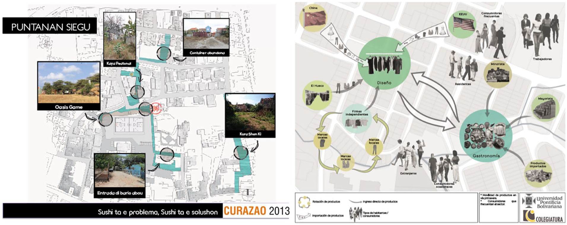
Left: Sensory map of the intervention area in Willemstad, Curaçao. By Sofia Saavedra Bruno (Curacao, 2013). Right: Sensory map of Via Primavera in Medellín. By Research group MCE (Medellín, 2017).
Comparing different sensory maps created in each of the five cities
1
between the communities and the research group allows researchers to identify characteristics, social phenomena, and recurrent development ideals the inhabitants had for their spaces, now transformed both positively and negatively. Albert Macaya-Ruiz in his text Trayectos en el mapa: artes visuales como representación del conocimiento[Paths on the map: visual arts as a representation of knowledge] (Macaya-Ruiz, 2017) assesses what today would be considered an “expanded cartography” and also the recognition of the researcher, from his individual voice, through new optics and new applications. In that sense, The appreciation of these aspects is justified by the interest in the research incorporating innovative methods that go beyond “listening” and “observing” using multiple media, including visual, sensory, and movement. And in that the investigation also goes beyond writing in the representation of what is observed, opening up towards artistic practices. This expanded field of research thus enables new ways of understanding the products it generates. (Macaya-Ruiz, 2017, p. 389)
2
Understanding the importance of not being reductionist in understanding the complexity of urban transformation, and more depending on comparing the journeys of different cities, is one of the most important factors when doing socio-special research. Now, to allow that from the sensitive experience of each researcher the information is embodied, and taken as food and not as a disturbance, is an important step in recognizing researchers also as subjects involved in spaces.
Regarding mapping and dematerialized representation of the city, there are other activities that should take place in analyzing urban morphology and transformation. These exercises have the aim to derive both from the need of representing different ways of living the city and from Facinelli’s critical considerations on the functions of mapping (Farinelli, 1992, 2009); according to this, other topographied, not limited to the morphological appearance of urban elements, may include depiction of the city under transformation through the impermanent presence of new inhabitants. In this context, maps, such as metal maps or sensorial maps, become tools to try to describe cities, Latin American in this case, differently from how they have been represented and conceived (Bocchi & Ceruti, 2009).
Through the drawings of the map, communities and researchers develop a sense of belonging in the city. The representation of the urban landscape drawn by different actors is a gesture of self-organization within the city. The action of imagining and drawing the urban geography corresponds to the act of mentally inhabiting the city, and in this way taking possession and transforming it from a space of estrangement into a space which is more articulated. We can say that the gesture of mapping makes explicit the act of taking to oneself a space which, no longer about an estranging experience, changes into a space open to unpredictable inhabiting conditions.
Drawing and Redrawing as a Tool for Urban Analysis
Drawing is the primary tool for rapprochement. As analysis tools, drawings can be divided into two groups: first, drawing as a form of inventory; second, drawings which allow viewing the proportions and visual relationships between places and architectural pieces located there through the focus of interest of the person drawing. In the first group of drawing tools, drawing as a form of inventory (that includes sensory mapping, and most of which are blueprints—technical drawings of the territory or the city), it is possible to clearly distinguish that infrastructure works both as furniture and as scenarios, which serve as physical determinants for spaces.
We can understand the relationships between places and their connections to their immediate surroundings by plotting mobility flows (see Figure 2) as most of the physical layouts of the cities studied are structured by lines and roads that have conditioned a sense of both territorial ownership and their neighborhoods, as stated by Jane Jacobs (2011, p. 55): “The streets and its sidewalks, the main public places of a city, are its most vital organs”

Collage made by redrawing blueprints of Medellín and drawings of the growth of structures within the city of Medellín (Medellín, 1944).
Through these drawings, it can be seen how one repetitive policy for new public interventions is to widen public spaces that articulate transitions with buildings and their connections to the main infrastructure, road, and landscape conditions. However, in some cases, these are not targeted or correlated appropriately. It can also be seen how urban furniture is distributed throughout these spaces and how it connects to activities proposed for them. One can also highlight in these drawings the factors that oppress the spaces, such as noise or lack of infrastructure. Díaz-Moreno states that Drawing as a city analysis tool always requires a process of redrawing, outline repeatedly what is embodied in two-dimensional images, whether these planes or aerial photographs. Redraw and discern, separate layers of information to reunite them by creating new relationships. But the image of the city is also one that is not reflected in the plans or orthophotos, the image of the pedestrian or the user. Its three-dimensional representation is also part of the graphical analysis. (Hernández et al., 2012, 1.-El dibujo como herramienta de análisis section)
This perspective allows the researcher to understand the space, and what happens in it, through its historical aspect, from the transformation and not from the static or stationary, from the modifications and alterations based on a specific category—in this case, a public policy.
From this, we connect to the second group of drawings that analyze places, which can be called sensory perspectives. Volumetric drawings for instance, which do not require dimensions, provide a proportional visualization of the ways in which places are set up and related to structures and the landscape, as well as the ways in which they are appropriated by residents and passersby. Through this group of drawings, we can perceive a description of the place’s atmosphere: “Atmosphere, character, and sensory qualities are becoming key factors in the definition of places, even from an economic perspective” (Zardini, 2005, p. 24) (see Figure 3).

Perspective drawings of the Casa de la Memoria building and its contextual relations.
We must clarify that, in these drawings, the recognition of the atmosphere corresponds to the unique structure of each place studied, and that behaviors and shapes are different in each case. However, the elements of these representations end up being the same (streets, sidewalks, furniture buildings), and those that change are weather, light, and smell, just as Christian Norberg-Schulz mentioned when referring to the spirit of place, the Genius Loci. According to an ancient roman belief, the Genius Loci is like the guardian spirit of every being; it gives life and character to people and places, determining their essences. It denotes what that being is, and when it is about places, it translates the idea of space into something more meaningful. That is important because in addition to the artifactual vision and the recognition of material characteristics, this kind of drawings let researchers identify the symbolic relationship and the most important or lowest points of identification about the landscape.
Elizabeth Zenteno Torres in her text La percepción del espacio urbano [The urban space perception] (Zenteno Torres, 2018) affirms that The city and everything it include cannot be considered in themselves without taking into account the content, value or readings that are made of these urban objects, the trajectories (Certeau, 2012) that are carried out inside the city constitute the very content of the territory (Ragonese, 2006). That is, the city cannot be regarded as an innocuous or objective space, but, on the contrary, it is loaded with subjective meaning and acquires a symbolic value (Caravedo, 2012). (Zenteno Torres, 2018, p. 105)
Therefore, city and territory are loaded with material and symbolic meanings that need to be reviewed, analyzed, and studied through different methods that will allow the understanding of these types of information in multiple levels, and finally, it allows researchers and urban planners the use of data to transform the city and the social living circumstances.
Following the work of Ayala and Koch (2019) about nonconventional methods that can support ethnography, they state that “The plasticity of the drawings brings it into a privileged meaning-making place” (p.3), and that this contributed to a more fluid construction of a hermeneutical bond, because the significant load and its evolution are given by the participants, not the researcher. In this way, drawing and redrawing being a tool to providing information on the formal characteristics, it also allows to collect information on the symbolic social processes of what inhabits the place, adding to the analysis a vivid and realistic perspective without which one could comprehend by completing the phenomenon studied.
Photography as a Research Tool
The use of visual research methods has become increasingly widespread throughout the social and human sciences. From their origins in disciplines such as social anthropology and sociology, visual research methods are now firmly rooted in major fields of inquiry, including urban studies, educational research, and cultural geography; media and cultural studies; management and organization studies; and political science and policy analysis. The fast development of information technology, facilitating the creation and editing of digitized data, and computer-based techniques for the storage and management of visual data allows new methodological approaches to be developed. (Doucet, 2019; Elshater, 2018; Knoblauch et al., 2008)
In this sense and as some scholars have pointed out, visual methods enhance the richness of data by discovering additional layers of meaning, adding validity and depth, and creating knowledge. They add to traditional methods by capturing more detail and a different kind of data than verbal and written methods. (Xantle, 2017, p. 2)
Photography, on the contrary, has been adopted by a wide range of approaches within social and human sciences that focus on the peculiarity of the visual and its specific symbolic structure, and has been used as a method for multiple disciplinary analysis.
In general, we refer to photography as a method that applies to a wide range of research strategies: from analyzing and interpreting photos taken by research groups to having inhabitants take photos of themselves in relation to the space they inhabit. It is important to acknowledge that Any photograph may have ethnographic interest, significance or meanings at a particular time or for a specific reason. The meanings of photographs are arbitrary and subjective; they depend on who is looking. The same photographic image may have a variety of (perhaps conflicting) meanings invested in it at different stages of ethnographic research and representation, as it is viewed by different eyes and audiences in diverse temporal historical, spatial, and cultural contexts. (Pink, 2001, p. 51)
Pink encourages the use of visual technology but urges the researcher to be versed on what may transpire as a result of combining this method with qualitative research.
The use of images allows a complex understanding of social phenomena based on a visual appropriation of spaces along with new and existing records, building parallels between historic and current user and researcher perspectives. This visual appropriation is a starting point for developing collective visions of the city and how it connects to the social purpose behind macro projects or urban interventions. During the phase of collecting information, looking for evidence of these macro projects in the cities already mentioned, researchers used two types of photography: (a) environmental photography with qualitative aspects that encourage evaluating relationships between the space and its users, daily life, and overall atmosphere; and (b) a technique with more quantitative characteristics that helps understand the spaces’ physical proportions and morphological behavior. All this is done by using historical photographic archives and comparing them with photographs taken by the researchers in the field to understand different narratives and social phenomena.
As John Berger proposes, the first type of picture used are current-day ones that serve as research tools for describing spatial relationships, trying to find “defining moments” that bring us to events related to the ways of life and appropriation of these places by residents and passersby. Similarly, these images allow describing and identifying the spaces’ textures, colors, and perceivable characteristics, which can point to the aesthetic qualities of the researched environments and population that inhabits them (Berger, 2000; see Figure 4).

Field work on the path of Casa de la Memoria, located along the development axis of the Santa Elena stream, Medellín.
These photographs provide support for drawings and analysis presentations, wherein the correspondence between the blueprints’ quantitative emphasis and details to be found in the photographs can be seen. The second type of photograph incorporated into the analysis are historical pictures taken by photographers with training in aesthetics and composition and can be found in the photographic archives of the cities where this analysis is performed. In these archive photographs, researchers can find three factors that define the interests through which the reconstruction of these places was approached. The first one is related to the composition in terms of the figures and the ground; the second, to geometry in terms of vanishing points and the observer’s position regarding image configuration; the third has to do with the idea or concept related to the expression of the subject of the photograph, which refers directly to its context (See Figure 5).
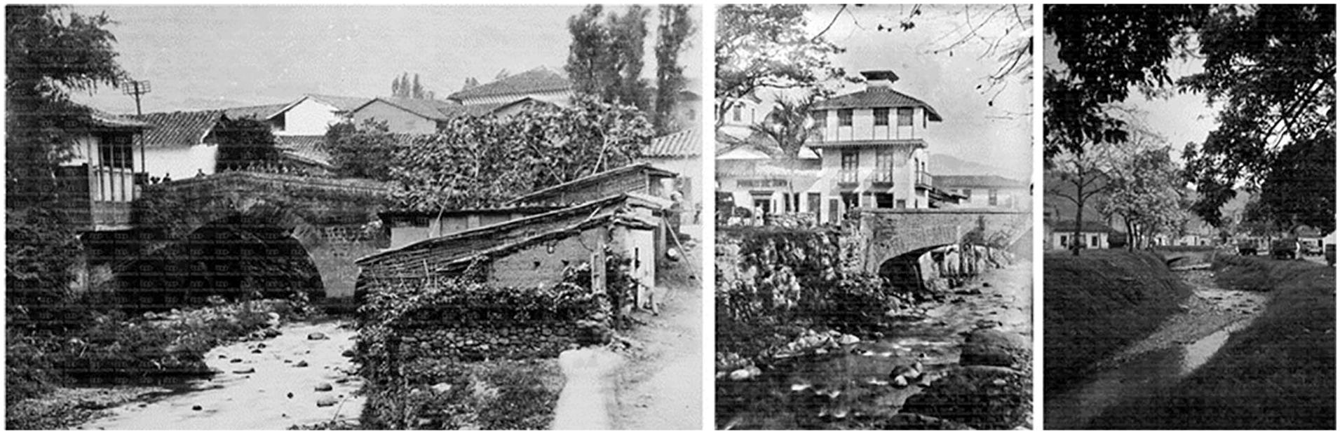
Collage. Left: Historical photograph of the Santa Elena stream’s development axis. [Photograph by Rafael Mesa] (Medellín, 1900). Digital archive. Biblioteca Pública Piloto, Medellín. Retrieved from: http://www.bibliotecapiloto.gov.co/archivo-fotografico. Center: Junín bridge. [Photograph by Rodríguez] (Medellín, 1900). Digital archive. Biblioteca Pública Piloto, Medellín. Retrieved from: http://www.bibliotecapiloto.gov.co/archivo-fotografico. Right: La Playa, Santa Elena. [Photograph by Gabriel Pérez Carvajal] (Medellín, 1900). Digital archive. Biblioteca Pública Piloto, Medellín. Retrieved from: http://www.bibliotecapiloto.gov.co/archivo-fotografico.
Memories are reconstructed by comparing historical photographs with more recent images showing the progressive or radical transformation of those places. These changes can be described simultaneously from formal, historical, and environmental points of view, by identifying the same places of interest or photographed objects and in certain cases with the same focal points in the photographs being compared. It is also important to mention that in many comparative analyses, photographs can be correlated by identifying the observer’s point of view and his or her position within the blueprint of the place being studied. In this way, information from several pictures can be grouped and overlaid.
Visualizing photographs simultaneously and comparatively—with the goal of establishing criteria for identifying common characteristics among the images—is a method of visual analysis belonging to the historiography of the art and its application as a strategy for iconographic analysis. It establishes the basis upon which images are formally studied. This type of analysis requires being complemented by a reconstruction of the cultural images of the environment. This could be done through documents, graphs, or additional images.
In this manner, images—and particularly photographs—are not isolated representations in a process of visual analysis. On the contrary, they play a key role in the process of understanding the impact and transformations a place is subjected to by identifying every formal variable that can be extracted from the photograph and simultaneously relating such variables to external documents. Reading and interpreting photographs require understanding initially that the process will be—very often—tied to the researcher’s (or the person analyzing the photograph’s) subjective critical and interpretative position. It takes a great deal of effort to minimize this risk factor but becomes necessary when seeking to establish an initial analytical approach through a contextual study of the image. Sarah Pink (2001), in her book Doing Ethnography: Images, Media and Representations, recognizes this as an important issue, but also encourages researchers to use visual methods in any context of researcher. So, for her “Images are ‘everywhere. . .’ They permeate our academic work, everyday lives, conversations and dreams” (Pink, 2001, p. 17)
The first step toward removing oneself from a viewpoint that is “too subjective,” is understanding the historical and social background of the photograph’s author and acquiring knowledge of the techniques she or he used. This allows the critic to approach a more accurate interpretation of the original conditions under which the work was created. Having acquired a less subjective opinion, the critic can now focus on a context governed by form.
The second step supports that compositional patterns define every image and make it possible to study them from a formal point of view. However, there are many aspects to and opinions on how to approach a formal analysis. As the researcher analyzes the image through a filter defined by his or her own perceptions, we can conclude that interpretational and subjective points of view now play a crucial role in the process: These images are actually capable of stealing reality because, above all, a photograph is not simply an image (in the same sense that a painting is), an interpretation of reality; it is also a vestige, a direct trace of reality, like a footprint or a mortuary mask. (Sontag, 2006, p. 216)
In consequence, finding the exact description and analysis of an image becomes a great challenge as no linguistic guidelines or precise language exists for decoding the images’ meaning.
Now, the third reading level is more a correlation between the previous two aspects. It studies the articulation of space and time by looking at types of perspective and rhythmical tensions in an attempt to interpret the inner meanings articulated by the image. The final step is to analyze the message presented by the image. To do this, we must identify key factors pertaining to the photographer’s vision and intention and the way her or his image is constructed. These factors include the location the photograph was taken, the photographer’s location, and his or her frame of interest (what the photographer decides to frame and in what direction). All images are influenced and mediated by the intentional actions of their author and the reasoning behind them.
Visual sociology recognizes photo-elicitation as an interview method that uses images for the purpose of obtaining commentaries. In this method, the interviewer provides images, videos, or drawings that generate commentaries and interpretations from the community: In simple terms, Photo-elicitation uses image as a motivation for discussing and developing narratives with its participants. This methodology implies that the researcher carries out a series of interviews that serve as a basis from which the participants can tell their stories and explain the photos, they took. (Alvarez, 2018, p. 125)
This method has become a highly effective ethnographic tool to reach a greater understanding of the way in which people relate to their habitat. It allows people and researchers to explore the relationship they have with a specific space and others who inhabit the same space. Photo-elicitation has three different strategies that are associated with the use of it: (1) researchers may use existing images linked to the research questions, (2) researchers can use their own pictures, and (3) researches can give cameras to the participants allowing them to take pictures (Glaw et al., 2017).
Graphical Reconstruction and Architectural Drawing Strategies
Finally, a graphical reconstruction is used as a tool for identifying urban and architectural strategies that suggest connections between usage and the user, seeking to understand and confront the intentions of the urbanists responsible for project development and infrastructure construction. It behaves as a temporal and spatial tracking method.
The exercise of redrawing architectural and urban structures is done to achieve a far wider understanding of the studied area, acknowledging the relationships between the city’s structures through morphological drawings, shapes, traces, and buildings. Methodologically, the way in which predrawn urban maps are presented responds to a type of organization known technically as grids. The different planes (depending on their characteristics, focus, or topic) are placed relationally on columns or rows. Grids allow communicating and displaying simultaneous issues and their correlations. This method of presenting information analytically is one of a group of interdisciplinary tools that appeared with the modern movement. It remains valid to the point it can be used for studying development processes and urban transformations as it is able to identify the individual characteristics of each case study. This facilitates comparisons with other cases and simultaneous visualization for continuously validating other studies.
Grids—in most cases—allow time lapse-based evaluations and display the impact and results of putting different strategies and urban development projects in place. They allow an optimal visualization of the structures in the cities being studied and how they compare with each other, with mountains or rivers as initial conditioners for implementation, and existing transportation routes and infrastructure as a second parameter.
The way the city’s structure is superimposed upon the territory’s morphological features directly conditions—mostly negatively– all issues of appropriation and relations within the cities that are being the studied. This negative effect results from the current view of development as an alternative driven by economic benefits. All of this, added to a rapid and inadequate territorial appropriation, is diminishing the importance of having structures that allow for healthy social exchanges and interactions with the landscape.
Using architectural tools, such as drawings and blueprints, we can understand a location’s distance, orientation and scale, and the spatial characteristics of the areas studied and can then, by comparing past and present drawings of these places, define a record of the changes that have occurred in its urban layout, road connections, and public space (see Figure 6).

Comparative blueprints of areas where trigger pieces were built.
The first level of analysis is to graphically locate “trigger pieces” or public buildings built in the last 10 years, in urban blueprints, structured from aerial views where topographical appropriations, relationships with natural structures, changes in paths, and increasing or decreasing public space can be compared. In this type of blueprints, we can also identify uses and variations that have arisen in relation to urban transformations experienced simultaneously by different places.
The second group of drawings are technical detail blueprints, wherein we can establish a relation between the human scale and the context to study the relations of scale between pedestrians, buildings, and public spaces. These drawings are mostly sections, quantitative representations of a building’s walls, platform, furnishings, and ceiling. Analyzing them will identify the spatial strategies used by architects and planners to establish the living conditions and usage of public spaces in relation to the buildings and areas in which they are located.
It is important to note that, although these exercises provide data on the urban and architectural morphology of the sectors studied, these results cannot simply be formal. There is evidence that the overall interest of the governments that plan cities includes the definition of strategies related to the development of said cities by designing roads and public spaces. Although this strategy provides information on physical conditions, it does not reflect social realities with any depth.
These three stages embrace the three dimensions considered in the research to build a wider perspective of the problem being analyzed:
Morphological space: consists of all that is observable as “dead areas” with no human interactions: land, natural environment, buildings, equipment, and so on. All of these result from human interventions.
Social, political, and economic space: refers to urban practices, citizen participation. and private and public behavioral analysis.
A connection between the previous two dimensions: the other/others in relation to the space; what/how people represent, perceive, and inhabit it.
Conclusion
The use of the analyzed tools and methods provided different positions vis-à-vis the objects of study, which, in addition to allowing the discovery of quantitatively verifiable information, opened the way to also include the researcher’s own vision—in addition, to also allow the recognition of space through the static and movement or superposition.
The three research tools analyzed in this article—mapping, drawing, and photography—define a recurrent method that creates an effect of distance, which increases the effect of designation (Pink & Alonso, 2004) and shows how urban dynamics can articulate submerged realities discussed through the visual sources that were exposed, allowing a closer relationship between the research and the representation that has been made. It is clear that a “static image” offers both advantages and disadvantages. It provides the researcher with the possibility of looking at a situation again from the point of view of any number of observers, expanding their social thinking.
Sensory mapping and the drawing and redrawing tool are also tools that, in a next stage of the investigation, could allow linking cultural aspects with the same transformation of the place. Identify how, to the extent that these images are created, they also speak of cultural moments typical of the analyzed space. It would be interesting to be able to do a historical follow-up of what the constant application of these tools could yield.
By simultaneously looking at various photographs and plans of intervention in different cities, we were able to identify reiterating development processes and similar reactions to urban transformations. The transformations undergone by Latin American cities in recent years have left deep marks mostly in the way formal and social structures are arranged and perceived. In fact, perceiving each of the analyzed cities and their transformations is a complex exercise, because one runs the risk that the image built at first glance by a person with no prior knowledge of the city can be chaotic. Even so, this image may also approach the image of a city renewed through “social planning” instead of simply structural planning. The sensory mapping tool is of great help when approaching this image from a social point of view; it allows delving into what photographs, advertising campaigns, or blueprints cannot describe: the “Genius Loci.”
Photography is a way to understand times and record changes. Photographic productions are useful for building formal references that account for advancing urban production and architectural constructions, and for revealing social practices and expressions of life throughout history. Currently, this way of using and producing photography is being adopted around the world, with an interest not in simply registering large urban developments, but rather in the way in which people relate to the urban environment, their life stories, and the way these connect to economic and social conflict.
Any answer to such a complex question, such as the one posed by this research project, requires restating traditional research methods and involving other nontraditional ones to thus acquire a global and more complete perspective of these phenomena. The senses, especially sight, allow researchers to analyze external occurrences. Visual exposure allows them to go farther and observe in greater depth other aspects presented by the culture and all the complex details in full; here, materiality is recognized as an agent that captures, presents, and exposes information. Therefore, we believe it is important to adopt, and in other cases restructure, other research methods that involve a variety of tools to achieve a wider and more complex analysis and understanding of the problem.
The tools and methods mentioned and discussed in the “Results and Discussion” section of this article can be applied to any group of cities in the world, and they do not need any certain or special urban circumstance, such as urban transformation processes, like the ones studied by the researchers in Medellín, Colombia and Willemstad, Curacao. The advantage of this group of tools in the cities studied is that they allow a more fluid circulation between their processes of social complexity. Recognizing the difficulties and particular characteristics of each community, which respond little or nothing to planned and articulated cities, a research tool that comes from a complex thinking space provides a flexible position in front of the data, the observer, the people, their experiences, and the lived reality. It does not mean that these tools do not work to make observations in the urban transformations of other cities, simply that they present advantages for the analysis of these.
Footnotes
Declaration of Conflicting Interests
The author(s) declared no potential conflicts of interest with respect to the research, authorship, and/or publication of this article.
Funding
The author(s) disclosed receipt of the following financial support for the research, authorship, and/or publication of this article: This work was supported by the Universidad Pontificia Bolivariana.