
Abstract
Antakya, also known as Antioch, is a special historic city for many reasons. It has maintained a unique blend of authentic values that result from a deep historical background, a rich culture, and a diverse religious population living together with tolerance and in peace for centuries. As a city in the southeastern corner of Turkey near Syria, its rich cultural identity is reflected in various aspects and parts of the city. Kurtuluş Avenue is one of the major urban axes of Antakya and is a remarkable case. It stands out from other parts of the city for having a unique architectural style that is defined by an interesting group of buildings with characteristics between vernacular and modern. Kurtuluş Avenue, a version of the ancient Herod Road, was widened and redirected during the French Mandate Period. Half of its buildings were demolished and renewed and the other half were renovated and reused, creating this particular group of buildings that define this new main artery with a new Western architectural style. The buildings are the products of a nuanced synthesis with common references to vernacular and modern architecture. Kurtuluş Avenue can be considered as a good example for the reflections of the transformations from vernacular to modern architecture and can help to understand this process from a different perspective. With the aim of analyzing, defining, and presenting the reflections of the transformations of urban and architectural characteristics of the buildings located along Kurtuluş Avenue, urban morphology and typo-morphological methods are used.
Keywords
Introduction
Antakya, also known as Antioch, is a special historic city in Anatolia for many reasons. It has maintained a unique blend of authentic aspects that result from a deep historical background, a rich culture, and a diverse religious population. As a city in the southeastern corner of Turkey, near Syria, its rich cultural identity is reflected in different parts of the city. For example, Kurtuluş Avenue is one of the major urban axes of Antakya and it is a remarkable case. It stands out from other parts of the city for having a unique architectural style that is defined by an interesting group of buildings with characteristics between vernacular and modern.
Kurtuluş Avenue, following the path of the ancient Herod Road, was widened and redirected during the French Mandate Period. Half of its buildings were demolished and renewed and the other half were renovated and reused, creating this particular grouping of buildings that define this new main artery with a new Western architectural style. The buildings are products of a nuanced synthesis with common references to vernacular and modern architecture. Kurtuluş Avenue could be considered a good example from a different part of the world, as its reflection of the transformations of 20th-century architecture could help with understanding this evolution process from a different perspective. At a different geography with different dynamics, Kurtuluş Avenue brings vernacular and modern characteristics together in an unusual and remarkable way. With the aim of revealing these urban and architectural characteristics, urban morphology and typo-morphological methods are used to analyze, define, and present the buildings’ distinctive characteristics. This study will include the analysis and definition of the characteristics through a comparative study of the buildings on Kurtuluş Avenue that were built shortly after the avenue was widened in 1927 with the earlier vernacular houses of Antakya, and with the modern urban houses built during the late 19th to early 20th centuries in the urban commercial zones of Turkey.
Theoretical Framework
Urban morphology is now a wide-ranging interdisciplinary field, including the study of human settlements, their structure, and their processes of formation and transformation (Kropf, 2018). Study of the built environment starts with an elementary cell of the urban fabric and its relationship to other elements. Depending on the focus and the qualities of the case, the characteristics, relationships, and interactions of the urban elements—building, open space, building lot, street, block, district, and the city as a whole—are studied at different scales and interpreted. For instance, the street could be the cell studied as the elementary element of the urban structure. Urban morphology explores the process of genesis from a certain period, the interim states of flux, and the existing situation of the urban whole, as well as its elements. It tries to read and define not only the physical changes but also the consequential social, economic, and cultural changes (Mıhçıoğlu Bilgi, 2013).
With the aim of capturing the city’s unique spirit and qualities where the traces remain and inherited to future, several generations of scholars from a variety of disciplines and countries have been active in the field of urban morphology with different approaches. Following the studies of the most influential initiators in the field, urban planner and geographer M.R.G. Conzen, and architect and academic Saverio Muratori, the main approaches for this study became clear. One of these approaches is known as the typo-morphological approach. It was initiated based on architect and academic Saverio Muratori’s (1959; Muratori et al., 1963) “operational history” studies and continued in the “procedural typology” studies of his major follower, Caniggia (Caniggia & Maffei, 2001). Both had a focus on building types as the elemental root of the urban form. This approach is used widely in the fields of architecture and urban design 1 and was the inspiration for the analysis of the case study in this article.
The typo-morphological approach was developed within the context of architectural practice and education in the first half of the 20th century, initially in Italy, then in France. The approach was interpreted as a reaction to modern architecture and refusal of modernism or neglect of history. It seeks to inform architectural and urban proposals with a critical understanding of the built environment as a context for development by examining its detailed structure and the historical process of its formation. It also seeks to understand the formative processes and evolution of building types to inform specific design proposals (Kropf, 2018).
Carlo Aymonino (1967, 1974) also recognized Muratori’s view in establishing a strong connection between urban morphology and building typology while carefully keeping a critical distance from his attempt to identify structure with history (Marzot, 2002). The book of Aldo Rossi, his teaching assistant, Architecture of the City, has been published in 1966. The book explained his approach to the concept of city, focusing on typology as a fundamental basis for the architectural project (Rossi, 1966/2002) and assuming type is the idea or essence of architecture itself (Oliveira, 2016).
Institut Parisien de Recherche Architecture, Urbanistique et Société, IPRAUS, an architectural research center in Paris, took the Italian research notions developed by Aymonino and Rossi and blended them with French typo-morphological notions. The main point of the blended method is the reevaluation of the concept of architectonic typology (Koster, 2001). Parallel to the IPRAUS developments and following the dissolution of Beaux-Arts in France, architects Panerai and Castex together with sociologist DePaule founded a second approach at the School of Architecture in Versailles (Panerai et al., 1997). This approach, also known as Versailles School or French School, partly was based on Italian ideas but has a more theoretical–normative approach benefiting from vibrant intellectual discourse on urban life and engagement of powerful critics like sociologist Lefebvre and architectural historians Boudon and Chastel. An important part of the method is the reading of the spatial disposition as a direct result of earlier transformations, but it also has prescriptive purposes of developing a theory of urban design and identifying how cities should be built using written and graphic sources (Koster, 2001; Moudon, 1997).
Method
Keeping in mind the theory and the case studies of typo-morphological approach, as well as the data available for this specific case, this research is based on the outcomes of two site surveys. The first site survey occurred in April 2008, when participants studied early vernacular houses of old city of Antakya and later houses along Kurtuluş Avenue. The second site survey, conducted in October 2014, completely concentrated on Kurtuluş Avenue houses. Twenty buildings along this main axis in the historic center of Antakya were selected as the subject of this article because of their common references to both vernacular and modern architecture.
Especially using the visual expression of typo-morphological approach, a comparative analytical method will be used to define the similarities and differences with the other two related groups of buildings: first with the earlier vernacular houses of Antakya, then with the modern urban houses built during the late 19th to early 20th centuries in the urban commercial zones of Turkey, which will be categorized with respect to each building’s location and access, ground floor plan typology, upper floor plan typology, façade typology, and structural system and materials.
Urban Characteristics of the City
Antakya (also known in antiquity as Antioch the Great, Antioch on the Orontes, Antioch of Syria, or Antiocheia) is the administrative center of Turkey’s southernmost province, Hatay. The city is located on the border with Syria and was established at the crossroads of three regional throughways serving military and commercial purposes (Aktüre, 1999).
As Downey mentions, with its Hellenistic foundation, Antioch had all the advantages of contextual siting and planning and was one of the most fortunate cities in the area. It was located in the prosperous, water-rich, and well-drained northwest corner of Syria and was a convenient distance from the sea—close enough for easy travel, but far enough for safety. It had a water system supplied by an aqueduct that carried water from Daphne. The streets were laid out northeast to southwest, and northwest to southeast in a gridiron pattern to catch the breezes blowing up the valley (Downey, 1962). In addition to its topography, the Mediterranean climate, and related temperature, precipitation, and wind conditions, and the city’s traditions and social life are major forces affecting its historic urban and architectural characteristics (Arıman, 2002).
The city’s core zone has comprised the area between Mount Silpius (Habib Najjar Mountain) and the River Orontes (Asi River) since its founding (Açıkgöz, 2008). Although the ground plan was mostly conjectural, the ancient city had straight streets intersecting at right angles. Those routed toward east and west, ran roughly parallel to the river, and natural obstacles were, when possible, smoothed away. The general form of the city is irregular and oblong, with the greatest extension in the east–west direction. Historically, it was enclosed in walls more than 12 km long (Bouchier, 1921; Tekin, 1993). Aktüre (1999) presented evidence supporting the idea that all the cities established by Seleucus I Nicator, the successor to Alexander the Great around 300 BCE, were built with the same gridiron plan, which used blocks (insulae) of a uniform size (112 m × 58 m, nearly a 2:1 ratio). Antioch, including its port of Seleuceia Pieria, Apameia, and Laodiceia, are several examples (Aktüre, 1999). The city pattern has shifted to organic, through the formal changes of building lots and roads, and implementation of dead-end streets, under Islamic influences on the city in later periods (Ömeroğlu, 2006; Figures 1 and 2).

(Left) Ancient Antakya with gridiron plan; (right) gridiron plan, organic Ottoman urban pattern, and Kurtuluş Avenue.

(Left) Antioch in the Roman Period; (right) Antakya in the Ottoman Period.
Modern Antakya has mostly preserved its organic street patterns, developed within the grid iron pattern (Açıkgöz, 2008). Despite the French Mandate’s (1918–1937) call for demolitions, extensions, and general rebuilding, as were performed in the other colonial cities in Syria and North Africa, Antakya’s rich architectural heritage was preserved (Açıkgöz, 2008). Large-scale urban transformations could not be realized in the historic core of Antakya where its residential fabric, extensive bazaars, prevalent religious landmarks, ancient city walls, and archaeological remains prevailed. The municipality of Antakya, however, did carry out a number of projects, such as the opening of new roads, the construction of significant buildings (e.g., a slaughterhouse), and the installation of other infrastructure under the mayor of Süreyya Bey (Açıkgöz, 2008; Figure 3).

(Left) Aerial photo of Antakya in 1932; (top right) 1931 Antakya map and Kurtuluş Avenue; (bottom right) aerial view of Antakya in 1932.
Kurtuluş Avenue
One such project occurred on what is now called Kurtuluş Avenue even though this avenue has a long and prominent history. In the Hellenistic Period, this roadway ran alongside a Seleucid settlement. Later, it has eventually become the main street used by the Romans (Downey, 1963). During the Roman Period, one of the principal undertakings was the construction of great colonnades for two Roman miles (2,962 m or 9,720 ft) along this street. In that time, the roadway width was 9.45 m (31 ft) and each of the porticos were 9.75 m (32 ft) deep. Together, they formed a broad main axis in the city. King Herod supplied the paving for the street, so the street was called Herod Road. Later, Tiberius built roofed colonnades and erected tetrapyla 2 at each main cross street (Downey, 1963). The colonnaded road, which constitutes the base of today’s Kurtuluş Avenue, ran parallel to the River Orontes (Asi River) and on an axis that reached the road to Aleppo-Latakia (Tekin, 1993).
The colonnaded streets of Antakya reflect those found in the ruins of Palmyra, as was common to many Syrian towns of the time. These primary roads were covered with polished marble and the columns on both sides were, in many cases, surrounded by statues on these colonnaded streets (Bouchier, 1921). The colonnaded street that has laid out from northeast to southwest, in the place of current Kurtuluş Avenue gradually faded due to repeated earthquakes, the encroachment of tenants, and a general transformation in the city pattern (Ömeroğlu, 2006). The results of a detailed archaeo-geophysical investigation in 2014, which used a georadar, or ground penetrating radar (GPR) technique, indicated that the remains of the Roman colonnaded street are 5 m below the level of today’s Kurtuluş Avenue, according to information coming from the GPR reports in the Antakya Municipality archives (Antakya Municipality, 2014; Figure 4).

(Left) Restored plan for Antioch, depending on the excavations of the 1930s; (top right) plan for the Roman Period’s colonnaded street; (bottom right) colonnaded street shown in a mosaic, with colonnades at 28 and 33 and the statues between 29 and 32.
In the Ottoman Period, the commercial area on Kurtuluş Avenue reached from Great Mosque to Uzun Çarşı Avenue. Kurtuluş Avenue was one of two main arteries of the city and the spaces alongside the avenue were reserved for various types of professions. Small workshops, khans, and soap factories could be found in this area that comprised almost a quarter of the city (Ömeroğlu, 2006). The streets soon became deformed by encroachment. They became narrower and more winding; they had lost the straight, broad character of streets in the Roman Period (Tekin, 2000).
In the early 20th century, the need arose for wider roads, but by then, the avenue had become barely passable. Simultaneously, an opportunity emerged for city planning. As part of the French Mandate, the French government completed an extensive cadastral survey and prepared 1/500-scale cadastral plans between 1926 and 1929. Certain planning studies, practices, and infrastructural improvements were executed under the supervision of Halefzade Süreyya Bey, the mayor at the time (Rifaioğlu, 2014). The most important intervention in the ancient city was the widening and redirection of the old Herod Road. The construction works were started in 1927, and the road was finally opened to traffic in 1935. The name of the avenue was changed from Kışla-Dörtayak to Rue Jadid during the French Mandate Period. This intervention provided a main artery in the city, facilitating the movement of vehicles and goods in the city center. It would eventually connect the interregional Aleppo Road with Harbiye Road (Açıkgöz, 2008).
During the intervention process, planning decisions resulted in the demolition of half of the buildings along the route. The other half were renovated and returned to use. The renewed and replaced buildings came to define the street and mark the official image of the main artery for Antakya (Açıkgöz, 2008; Tekin, 2010). With its new European architectural style, the avenue soon became the location of choice for the bureaucratic elite and other wealthy families of Antakya (Rifaioğlu, 2014).
After the French Mandate, the avenue was renamed Kurtuluş (meaning “liberation”). It is 11 m wide and 1.3 km long today. Habib Najjar Mosque is located at a midpoint along the avenue and serves as a landmark for this long axis. Some buildings on Kurtuluş Avenue reflect the late 19th-century styles of Ottoman residential architecture; these are completely different from the colonial architecture found elsewhere in the city. In addition, new building types along the avenue synthesize Antakya’s vernacular architecture, late architectural approaches used in Ottoman cities, and contemporary building techniques and materials (Figure 5).

(Top left) Plan for Antakya and Kurtuluş Avenue in the late 1960s (Hatay Eski Eserler Derneği Yayınları, No. 3); (top right) general view of the city in 1973, with Kurtuluş Avenue indicated by a red line; (bottom left and right) Vviews from Kurtuluş Avenue.
Herod Road, in the Hellenistic and Roman periods buried and faded with natural and artificial causes, then Kurtuluş Avenue reappeared in the same path in the Ottoman Period and transformed in the French Mandate Period, changing character multiway, will be scrutinized.
Analysis and Comparison of the Building Typologies on Kurtuluş Avenue
Although the districts through which Kurtuluş Avenue passes have different social and physical characteristics, the features along the avenue are relatively homogeneous. There are differences in detail and craftsmanship, but only rare discrepancies in mass relations and spatial characteristics.
The goal for this section of the research is to define and present the unique characteristics of this group of buildings. According to the site survey of this study, the number of historic buildings on Kurtuluş Avenue is 52, of which 20 could be surveyed, 21 of them could not be surveyed, and 11 of them are historic monumental public buildings, which are out of consideration for this study. There are 61 completely new buildings, or too altered–renewed historic residential buildings. In that sense, out of 41 historic residential buildings on Kurtuluş Avenue, which shall be called as “buildings of interest,” 20 of them could be surveyed both externally and internally mostly, 3 which is 49% of the whole of buildings of interest, and this group will be called as “Kurtuluş Avenue Houses.”
According to the site survey, for ground floor typology, 19 buildings with 20 ground floor plans are included, as one of the Kurtuluş Avenue houses consisted of two dwellings at the ground floor. For upper floor typology, 19 buildings with 21 upper floor plans are included, as two of the Kurtuluş Avenue houses consisted two dwellings. For façade typology, 20 buildings with 20 façades, and for structure and material analysis, 20 buildings are used in the analyses (Figure 6). Their original qualities and original schemes were taken into consideration, whereas recent alterations were ignored.

Map showing Kurtuluş Avenue study area and the places of the selected buildings.
To analyze and define the characteristics of the buildings on Kurtuluş Avenue that were built shortly after the avenue was widened in 1927, two types of comparisons are made. First comparison is made with the earlier vernacular houses of Antakya, which will be called as “vernacular Antakya houses,” to explore the similarities and differences between the earlier vernacular residential architecture of Antakya and the buildings of interest on Kurtuluş Avenue. Then, second comparison is made with the modern urban houses built during the late 19th to early 20th centuries in the commercial zones of larger and more urbanized cities of Turkey that used to be models for smaller cities through nine examples from İstanbul-Kadıköy, İzmir-Urla, İzmir-Alsancak, and İstanbul-Kumkapı (shown in Figure 10), which will be further called as “contemporary commercial zone houses,” to explore the similarities and differences between the aimed group of buildings (Figure 7). Within this framework, comparisons are made with respect to each building’s
- location and access,
- ground floor plan typology,
- upper floor plan typology,
- façade typology, and
- structural system and materials.

Examples to the buildings of interest on Kurtuluş Avenue.
Location and Access
The selected buildings have mostly two stories (18 buildings, 90%); the remaining (two buildings, 10%) are three-story buildings via addition of a mezzanine floor. They are all in parallel alignment and adjacent to one another along Kurtuluş Avenue. Most of these buildings do not have any courtyards or back gardens (68%), with the exception of buildings (32%) with courtyards such as the buildings numbered 20, 94, 134, 140, and 151 and buildings with backyards and the buildings numbered 46 to 48. Both the ground and upper floors of these buildings have individual entrances directly accessible from the street.
In comparison, all vernacular Antakya houses had courtyards, and their single entrances opened first to these courtyards and then the buildings were accessed from the courtyard. On a single building lot, several buildings would be arranged around the courtyard in I-, L-, or U-shaped configurations (Arıman, 2002). Each lot had buildings added over time and placed according to the needs of the occupying family; thus, each had different locational orders that were not repeated on neighboring lots.
Conversely, though similar to Kurtuluş Avenue buildings in some ways, contemporary commercial zone houses are mostly located on narrow plots, adjacent to one another, and perpendicular to the street; their entrances always lead directly from the street into these buildings.
Ground Floor Plan Typology
As a result of the common commercial uses of the Kurtuluş Avenue houses, the ground floors tend to have an extraverted and welcoming character. Entrances to single or multiple commercial spaces on the ground floor are accessed through wide openings with large doors and mostly featuring displays. Apart from residential entrances and their vertical circulation connections, these commercial buildings need to be accessible from the street (Figure 8). Twenty ground floor plans of Kurtuluş Avenue houses can be grouped into three categories according to their use.
1. Completely commercial:
ο Commercial spaces in a row (parallel to the street; 26%), as seen on Kurtuluş Avenue at building numbers 133, 134, 145–147, 152, and 158 (five examples).
ο One large commercial space (21%), as seen on Kurtuluş Avenue at building numbers 42, 57, 66–68, and 142 (four examples).
2. Commercial and residential together:
ο Commercial in the front and residential in the back (37%), as seen on Kurtuluş Avenue at building numbers 46–48, 86, 94, 140, 151, 156, and 171 (seven examples).
ο Commercial and residential, side by side (1%), as seen on Kurtuluş Avenue at building number 155 (one example).
3. Completely residential (15%):
ο As seen on Kurtuluş Avenue at building numbers 15, 20, and 159 (three examples).

Ground floor typology of Kurtuluş Avenue houses (by the authors).
Grouping of commercial and residential uses together at the ground floor is unconventional in the vernacular Antakya houses. Moreover, commercial uses of vernacular buildings are usually limited to khans, bedestans, arastas, and special areas such as bazaars in most Ottoman cities of Anatolia.
Under the influence of Mediterranean geographic and climatic conditions, vernacular Antakya houses are entered through a covered narrow entrance corridor called aralık. Aralık provide an indirect connection between the entrance and courtyard (Çelebi, 1982). Rooms on two or three sides, surrounding the courtyards, provide variety of spaces for both summer and winter uses. As a result of the introverted spatial character of the houses, the ground floors of buildings were completely closed to the exterior except for the street door. Vernacular Antakya houses were mostly two storied, separated from the street by high stone walls, and had cool and spacious courtyards under the shade of olive, cypress, pomegranate, lemon, orange, or myrtle trees. These characteristics allowed occupants to endure the long, hot summers in comfort. Generally, vernacular Antakya houses had rooms on one side. The main room was called başoda, which was the most decorated room and was used to welcome guests. Often there was an open or semiopen sitting platform called a seki located next to it, and service spaces such as the kitchen, hela (toilet), cellar/storage areas, and barns were located on the opposite side of the ground floor (Akın et al., 2005; Çelebi, 1982; Figure 9).

(Top left and right) views from the street and courtyard; (bottom left and right) plan examples from earlier vernacular houses of Antakya.
Contemporary commercial zone houses have commercial uses on their ground floors, but mostly only have a single unit in front of the residential unit or at the basement floor. Originally (neglecting later alterations), there was either a single door leading directly from the street to the ground and upper floors of residential units, or there were separate doors for the entrance to each commercial space and the residential space. Related to the topographic conditions, there also may have been a commercial space with a separate entrance at the basement floor in cases where street levels shift according to the terrain on each side of the building. Houses of this type usually have backyards (The Authors, 2012; Figure 10).

Late period residential examples from urban commercial areas in Turkey with partial commercial use together with residential service areas at the ground floors and residential at the upper floors.
Upper Floor Plan Typology
The upper floors of Kurtuluş Avenue houses were originally designed only for residential use, either as single or duplex houses. The access to upper level residences are always directly from the street through separate and private doors for each residential unit. The doors are situated at the sides or in the middle of the main façade. The upper levels are accessed via private staircases.
When we look at the vernacular Antakya houses, the first floors were always designed in connection with their ground floors, with an interior staircase located in one of the rooms. Multiple separate buildings surrounding the courtyard were built to accommodate the growth in the occupant family (usually through the children’s marriages), and subsequent generations were welcomed to build on and use the same building lot. Vernacular residential buildings constructed during the 19th century in other Ottoman cities were mostly similar to those in Antakya, even though there was a newly introduced residential typology without courtyard in larger cities toward the end of the century.
Similarly, Kurtuluş Avenue houses have many common characteristics with the “contemporary commercial zone houses.” Most of the houses of early 20th century had two stories and a plan with a sofa located between the side rooms. A sofa is a common space that is used for daily living and circulation in traditional Anatolian and Ottoman houses. The upper floor programs were more closely related to the ground floors due to where staircases were located and the first-floor plans usually mirrored those of the ground floors in other examples. The major difference between these contemporary commercial zone houses and the selected buildings on Kurtuluş Avenue is their orientation. Mostly because of being situated perpendicular to the street, contemporary commercial zone houses had narrow façades. Their rooms in the back did not have any openings facing the streets, whereas the Kurtuluş Avenue examples faced the avenue longitudinally with a larger street view. As a distinctive characteristic, the inner sofas of Kurtuluş Avenue houses always have larger façade openings and even additional skylights on their roofs (as seen at building numbers 64, 66, 145, and 155 on Kurtuluş Avenue) to make the houses feel spacious and full of light. This effort to achieve interior lighting resembles the traditional courtyards of earlier Antakya houses and became possible because of the wider façades parallel to the street.
On Kurtuluş Avenue, the buildings are large and spacious, with high ceilings on each floor. They generally include more than four rooms per residential unit, excluding service and circulation areas. Three buildings (16%) have two separate residential units on their upper floors, when 17 buildings (84%) have only one residential unit on their upper floors.
The upper floor plans for the Kurtuluş Avenue buildings can be categorized into two groups: those with inner sofas and those with outer sofas.
According to the organization of the spaces around the circulation area sofa, the plan schemes with an inner sofa have four different types depending on their shape.
I-shaped inner sofa, building either parallel (as seen for number 68) or perpendicular to the street (as seen at numbers 15, 48, 57, and 158);
U-shaped inner sofa (as seen in number 159);
L-shaped inner sofa (as seen in numbers 42, 46, and 94); and
T-shaped inner sofa (as seen in numbers 86, 151, and 152).
Plan schemes with an outer sofa only have an I-shape and are either open (as seen in number 142) or closed. Closed sofas are one of two types:
outer sofa at the corner (as seen in numbers 134 and 155) or
centralized outer sofa (as seen in numbers 20, 133, 140, 145, 147, 156, and 163).
In front of their sofas at the upper floors, all the selected buildings either have projections, or balconies. Eleven of the selected buildings have projections (without any balconies), three of them have balconies (without any projections), and six of them have both projections and balconies on their main façades looking over Kurtuluş Avenue (Figure 11).

Upper floor typology of Kurtuluş Avenue houses (by the authors).
Façade Typology
One common distinction of the Kurtuluş Avenue houses is that each upper residential unit has a separate, private door on the ground floor. Although the main façades facing Kurtuluş Avenue (if a corner building, it has a rear façade on the side as well) are quite elaborate with arched, trefoil openings, ornamented frames, ironwork, moldings, and pseudo-stucco (Figure 12), the rear façades are mostly ignored, sometimes constructed without any windows or any kind of architectural or decorative elements, as cannot be seen by the public. The forms and decorations on the openings are similar to those on earlier vernacular courtyard façades.

Details of the buildings on Kurtuluş Avenue.
With projections being the main element of the façade typology, the façades of Kurtuluş Avenue fall mainly into two categories: those with projections (17 buildings, 85%) and those without projections, but with balconies (three buildings, or 15%). Of 17 buildings with projections, six have balconies (35%) and 11 do not have (65%). In addition, at 13 buildings with projections, the projections continue along the entire façade (76%), and at four of the buildings (24%), the projections cover the façade partially, but mostly.
At six cases within the selected buildings with both projections and balconies, three of them have small French balconies without projection (46–48, 86, 158), two of them are small recessed balconies (152, 171), and only one of them is a small semiprojecting balcony on one side of the projection (133). However, at three cases within the selected buildings with only balconies without any projections, small balconies are the only projecting elements on the façades (20, 42, 158).
Similarly, the most important external features of vernacular Antakya houses are their projections, buttresses, and wide eaves. In such houses, the first-floor openings are wide in contrast to the mostly blind ground floors. Meanwhile, we did not observe such a contrary approach in the façade design of Kurtuluş Avenue houses due to shifting perceptions of privacy. The single doors into the courtyards of vernacular Antakya houses have plain arches. In contrast to their street façades, façades facing the courtyards are highly ornamented with advanced stone workmanship. After the elimination of the courtyard, which used to be the major element of vernacular Antakya houses, Kurtuluş Avenue house façades were handled as elaborately as the earlier inner courtyard façades.
However, when we look at the contemporary commercial zone houses with respect to the Kurtuluş Avenue houses, most have very narrow, limited-depth projections with curvilinear buttresses. They are designed according to building regulations put into effect due to catastrophic fires that occurred at many Anatolian cities in the past and affected the contemporary commercial zone houses (The Authors, 2012). Somewhat like the Kurtuluş Avenue houses, the street façades of the contemporary commercial zone houses have more advanced decorations, when their rear façades facing the attached gardens are comparatively plain, though often not completely ignored as much as the selected buildings on Kurtuluş Avenue. Ornamentation on the main façades of contemporary commercial zone houses usually carry classical features of antiquity, such as medallions, architraves, and volutes, demonstrating the influence of neoclassicism, more in number and emphasized than the ones on the selected buildings on Kurtuluş Avenue (Figure 13).
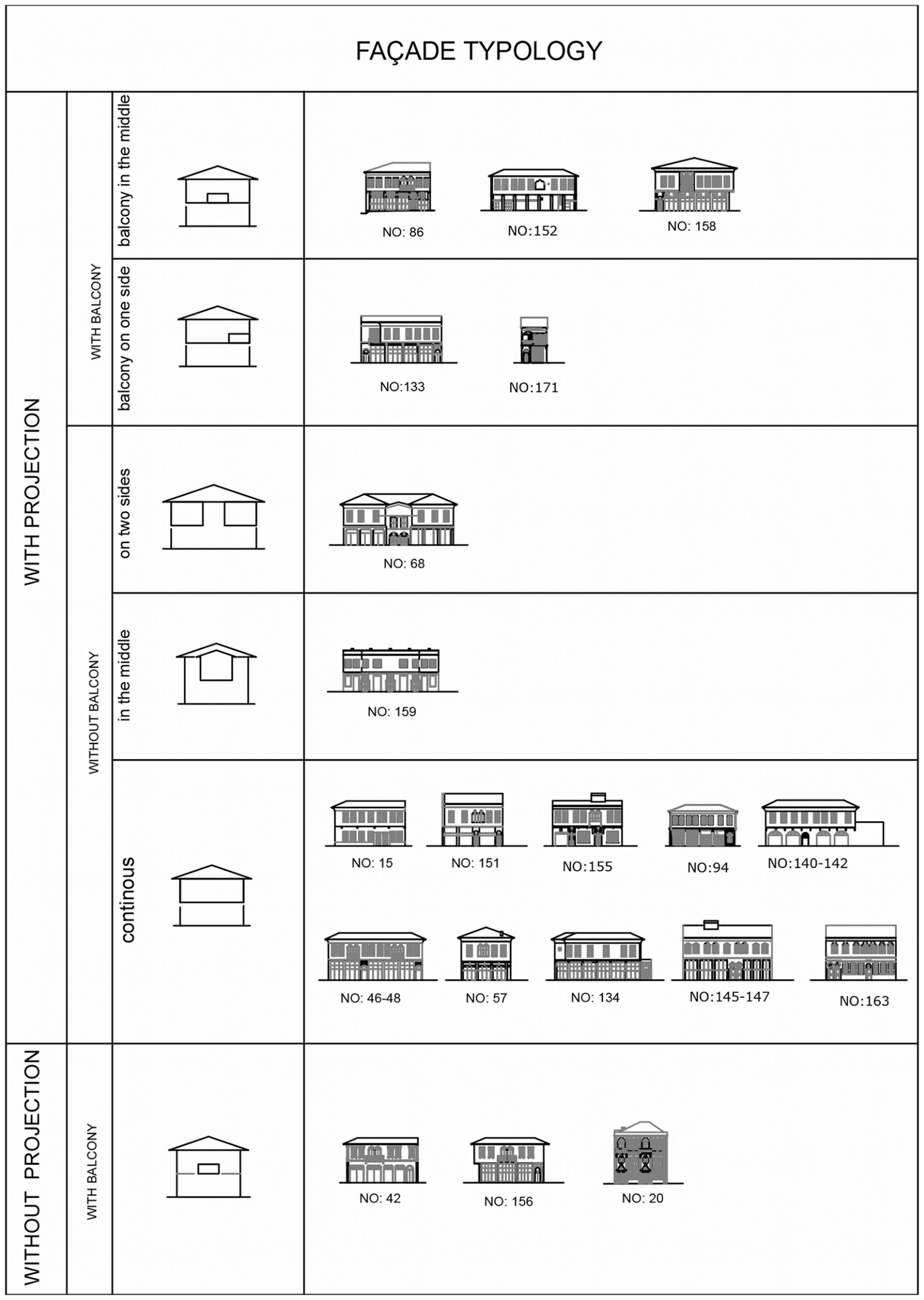
Facade typology of Kurtuluş Avenue houses (by the authors).
Structural System and Materials
The selected buildings on Kurtuluş Avenue primarily have brick masonry outer walls with timber posts and lintels, both on the ground and first floors. The inner walls are of a timber skeleton with timber lath cladding. There are also examples of timber skeleton frames with brick infill or timber lath cladding used for the outer walls of first floors. Reinforced concrete slabs supported with I-beams are used as flooring. Another floor type in the study area is vaulted brick with I-beam bracing. I-beams not only carry the floor slabs but also buttress the projections. The eaves of the timber roofs are veneered with timber and metal sheets. As mentioned above, in some examples, there are skylights on the roofs, over the sofas.
The outer walls of vernacular Antakya houses are of stone masonry, either for the entire building or at least for the ground floor. The system on the first floor is timber skeleton and interior walls are timber skeletons clad with timber lath. The floors are supported by timber beams and the projections have stone and wood bracings. The wide eaves of the timber roofs are also veneered with timber lath (Demir, 1996).
Contemporary commercial zone houses can have brick masonry outer walls both on the ground and upper floors. Inner walls have timber skeletons and cladding with timber lath. Generally, floors are structured with timber beams, but sometimes vaulted brick is used with I-beams. The projections are usually braced with metal buttresses and the buildings mostly have hidden timber-structured roofs without eaves but having cornices.
Evaluation
According to the abovementioned analyses, the following evaluations are derived.
Plot division as well as the tradition of placing building blocks parallel to the courtyards affected the development of this type of construction and can be seen on Kurtuluş Avenue. From vernacular Antakya houses, the relationship of the building block to the courtyard is reflected by Kurtuluş Avenue houses in the relationship of the building to the streets. This reflection can be seen in terms of orientation, access, individuality, and even, façade elaboration.
As a result of being located parallel to Kurtuluş Avenue, Kurtuluş Avenue houses have wide façades with larger openings, consequently with larger street view and rooms with more light unlike contemporary commercial zone houses, but spacious like the vernacular Antakya houses. The frontal avenue façades of Kurtuluş Avenue houses are elaborately decorated, as the highly ornamented courtyard façades of vernacular Antakya houses, when the rear façades are either ignored or blind. Instead of the elaborate stone workmanship at the courtyard façades of vernacular Antakya houses, pseudo-stucco is preferred on the frontal façades with or without projections with somehow similar earlier decorative elements.
The introduction of single or multiple commercial spaced uses—when completely commercial, in a row or as one large space, when together, commercial in front/residential at the back, or side by side on ground floors, with an extraverted and welcoming way, in contrast to private and noncommercial tradition and similar to contemporary commercial zone houses—is synthesized with the idea of individuality in vernacular residential buildings.
Wide openings on the ground floors related to commercial use are completely new after the blind façades of earlier traditional residential ground floors. Similarly, floor heights increased together with the enlargement of the fenestrations on the first floors.
Decreasing the complete privacy behind the blind courtyard walls of vernacular Antakya houses, the upper floors of Kurtuluş Avenue houses are used only for residential purposes either as single or double unit with individual accesses directly from the street from private doors and staircases. The use of a sofa in between the rooms, like the most of the houses of early 20th century, had wide glazing and a skylight on the roof at Kurtuluş Avenue houses, which is a very creative interpretation of and evolution instead of a courtyard. Parallel to the houses of early 20th century, the toilets became a part of the closed and heated area of Kurtuluş Avenue houses, unlike the vernacular Antakya houses located at the courtyards. As the courtyard is replaced with a sofa, the elements or spaces such as the well, pool, and woodshed at the courtyard of vernacular Antakya houses disappeared in Kurtuluş Avenue houses.
Contemporary technology was employed in the adaptations of Kurtuluş Avenue houses, such as the incorporation of I-beams with reinforced concrete was also a unique combination of materials from the modern era, though their form stemmed from the traditional use of rafters. Complete or partial use of stone masonry outer walls at vernacular Antakya houses is replaced with complete or partial use of brick masonry outer walls at Kurtuluş Avenue houses, when both used timber skeleton frames for the upper floors or inner walls, as well as the contemporary commercial zone houses.
The projections seem to be similar to those of earlier vernacular street façades; however, they appear to be wider and more elongated across the front façade in most of the examples. The latter probably results from the need to enlarge the first floor.
Under the light of this evaluation, it can be clearly stated that the design of this building type was influenced by both earlier traditional Antakya houses and concurrent tendencies in larger Ottoman cities, as well as the new building type that emerged on Kurtuluş Avenue in the early 20th century was a product of the transition from vernacular to modern.
Conclusion
The building type examined in this research is particular to Kurtuluş Avenue in Antakya though it was compared with building types in other parts of Antakya and in other cities across Turkey. The identification of this building type is important for understanding of local attitudes toward the modern age of architecture. The typo-morphological approach used to classify the urban and architectural characteristics of Kurtuluş Avenue houses, and the comparative method used to define the similarities and the differences from different aspects under the influence of local and concurrent effects are believed to be the best way to handle this kind of a study. The specific typology defined in this article is an unusual and distinctive case as a transition from vernacular to modern that must be conserved and kept as the evidences of this transition process. The architectural approach, which developed this unique group of building type, has already met and continues to meet the local needs of the inhabitants and their living habits by interpreting the local vernacular architecture and providing an excellent example of the effort to adapt vernacular to modern before modernity became much more dominant. The innovations employed to adapt traditions to a new type of living and emerging technologies in construction deserve further research. Apparently, reconsidering the diversity of societies and their local architecture, instead of proposing that they be standardized or globalized as residential and commercial units would help to improve the quality of built environments further.
Footnotes
Declaration of Conflicting Interests
The author(s) declared no potential conflicts of interest with respect to the research, authorship, and/or publication of this article.
Funding
The author(s) received no financial support for the research, authorship, and/or publication of this article.