
Abstract
Anthropogenic strata form the layered urban archive in the underground of large cities. In a transdisciplinary project involving geosciences, isotope physics and urban archaeology, we looked for artificial isotopes and anthropogenic trace metals. The tested archaeological site Karlsplatz is situated in the city of Vienna (Austria). Archaeology and historical data sets provide age constraints around 1922, post-1945 and at 1959. A layer on top of the WW2 rubble that covers foundations of a 1922 building post-dates 1945, and pre-dates the levelling of the artificial park ground in 1959. The fine-grained sediment matrix of these layers is mixed with backfilled soil material. Samples were analysed for trace elements such as lead, copper and zinc, and prepared for chemical separation of actinides analysed by Accelerator Mass Spectrometry (AMS). Several artificial radionuclides, including the plutonium and uranium isotopes 239Pu, 240Pu and 236U, were found in the post-1945 layer, and the 240Pu/239Pu isotope ratio clearly points to the presence of atmospheric atomic bomb fallout material of the 1950s. Thus, the bomb-spike can be identified and used as a primary stratigraphic marker even in coarse urban anthropogenic sediments, exemplifying the correlation potential of these radionuclide markers and marking a correlative reference section for the Anthropocene series.
Introduction
Today, urban artificial sediments form a major part of the global anthropogenic sediment mass load (e.g. Luberti, 2018; Terrington et al., 2018) and record the growing influence of humans on depositional processes, especially in the human-worked ground of cities from the Late Holocene (Meghalayan) to the Anthropocene. In urban areas, archaeological and geological stratigraphy meet within these youngest, often reworked sediment layers that build the uppermost urban ground (Edgeworth, 2014). Although not ideally suited to define the Anthropocene in terms of chronostratigraphic methods, requiring the definition of a base by a Global boundary Stratotype Section and Point (GSSP) (see Waters et al., 2018), anthropogenic urban sediments provide substantial, datable and significant geological archives for stratigraphic correlation. The preparatory activities of the Anthropocene Working Group, including events leading to the submission of GSSP proposals and the binding decision that the base of the Anthropocene should align with stratigraphic signals dating to the mid-20th century, are detailed in the introductory article to this special issue (Waters et al., 2023).
Vienna was selected as a site for a potential Anthropocene GSSP project on urban sediments based on the pioneering work of the Austrian geologist Eduard Suess (1831–1914), who produced the first geological map of a major capital city (around 1900, Vienna had about 2 million inhabitants), which included anthropogenic deposits, termed ‘Schuttdecke’ (rubble layer) by Suess (1862). Suess (1897) later published a further Vienna map, recording the changes within more than 35 years of city growth, especially the newly formed parts of his ‘Schuttdecke’, due to the demolition of old city wall and fortresses. Although, >40 m thick deposits are proved in the borehole core data base in Vienna (https://www.wien.gv.at/baugk/public/), sites with sediments dating from mid-20th century are comparably rare due to multiple reworking of the uppermost parts for construction purposes, including metro lines, buildings and underground parking facilities.
The settlement history in the Vienna area started at least around 5000 Before Common Era (BCE) when settlements were established along the Danube River in the early Neolithic period, or even before in the Late Palaeolithic (Schmitsberger et al., 2019). In the first century Common Era (CE), Vindobona, the Roman garrison town (i.e. military fortress and associated civilian settlements) with up to 30,000 inhabitants (e.g. Kronberger and Mosser, 2015), marks the birth of the city of Vienna. Ample Roman remnants were found in the city, especially in the first district near to the Danube River (Figure 1). However, most of the cores and excavated sections in and around the first district lack post-1945 layers of considerable thickness due to extensive reworking and construction.
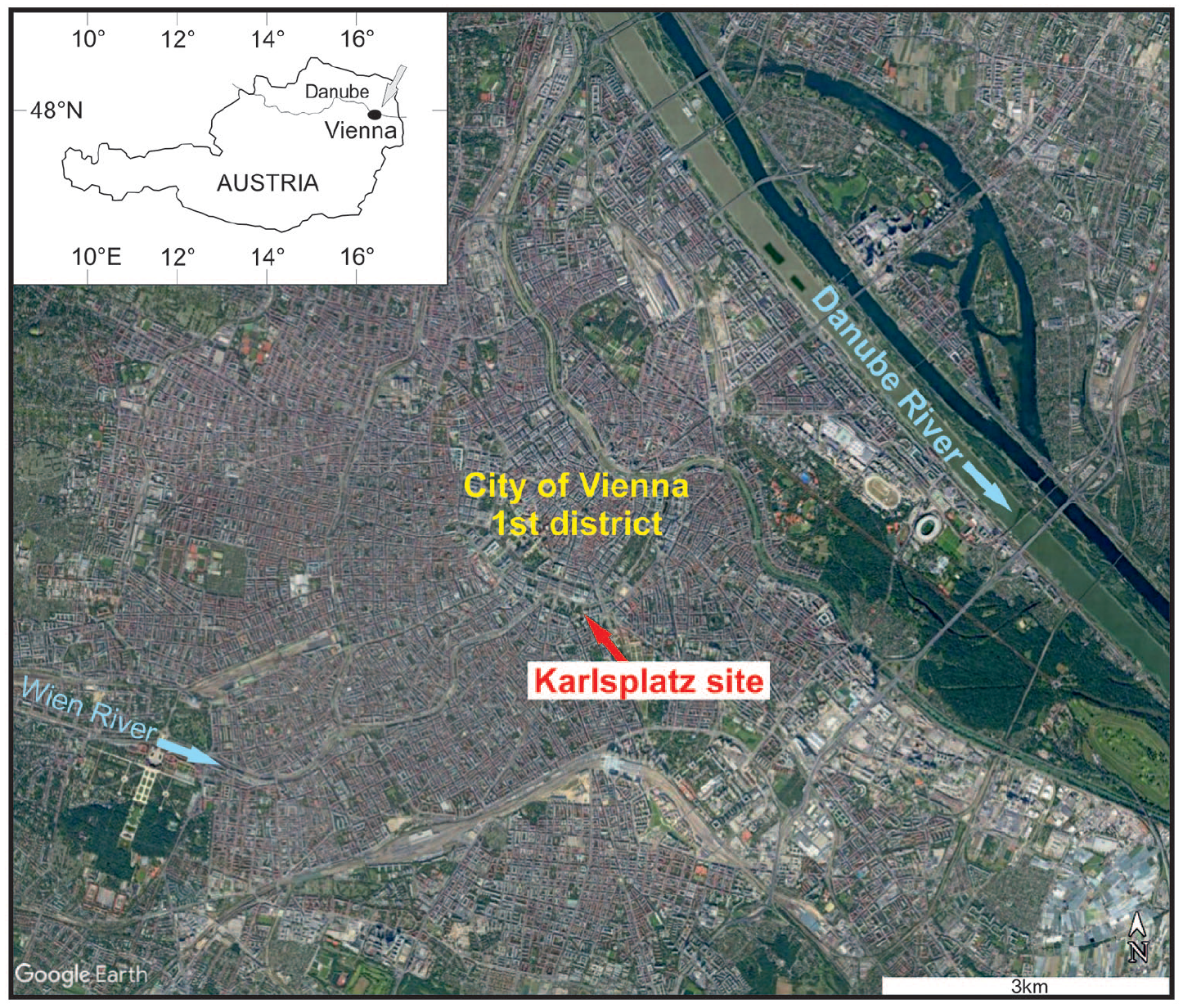
Google scene from the city of Vienna with the Karlsplatz archaeological site indicated. Inset shows the position within Austria, Central Europe. Reproduced in colour in online version.
Based on historical site investigations, the archaeological excavation site at the Karlsplatz (Figure 1), in front of the Wien Museum, was chosen as a candidate for a mid-20th century base of the Anthropocene. It includes the anthropogenic fill of the Wien River before 1900 and a levelling period of the park area in the 1950s which showed the potential of finding urban anthropogenic deposits and layers deposited during this decade. Therefore, the archaeological excavation was tested for artificial radionuclides from the elemental group of the actinides, such as plutonium (239Pu, t1/2 = 24,100 years) or uranium (236U, t1/2 = 23.4 million years), which accumulated in significant amounts only from human activities, that is nuclear weapons or reactors (e.g. Waters et al., 2015). Furthermore, the section includes some trace metals such as lead, copper and zinc which have a strong affinity to anthropogenic contamination.
Materials and methods
Geographic setting
The archaeological excavation Karlsplatz – Wien Museum (Vienna Urban archaeology site # 2019_26: Karlsplatz, Wien Museum, Vienna, Austria; Mosser, 2019; Mosser and Litschauer, 2021) is situated within the City of Vienna, the capital of Austria, close to the southern boundary of the first district of Vienna (Figure 1). Before 1860, the Karlsplatz site was outside the (mediaeval) main city walls, in a suburban naturally vegetated area in the vicinity of the Wien River, a tributary of the Danube. After the demolition of the city walls and fortresses starting around 1860, the area was part of a park located in front of the Karlskirche (church built in 1739), which was modified into an urban square during 1894–1900 by enclosure and vaulting of the Wien River into an underground canal and by filling the natural course of the river channel with urban rubble. From 1922 onwards, a sales hall (emporium) for luxury goods was situated at the site. After the end of WW2 in 1945, excavations for the construction of for the Wien Museum began in the 1950s with the park in front of the museum opened in 1959. Later construction work of the wider area, such as the metro in the 1970s, did not affect the actual excavation site. The geographic coordinates of the section are N 48.199167° E 16.372611° (the base of section is at an altitude of 169.92 m above Adriatic sea level).
Field collection and sampling
The archaeological excavation at Karlsplatz ran from October 7, 2019 to January 21, 2020, with reconnaissance work continuing until March 2021. The composite geological section at Karlsplatz consists of two parts, which were cleaned and sampled during October 25–October 29, 2019 (Figures 2 and 3). Sampling was done in ca. 10 cm intervals in the upper 64 cm of the first section (Figure 2, samples AZ3–AZ7). A composite section (Figure 4) was necessary in order to sample downwards because of the short lateral extent of individual archaeological layers such as the WW2 rubble, and the common existence of unconformities. Sample splits are archived at the collection of the Department of Geology, University of Vienna.
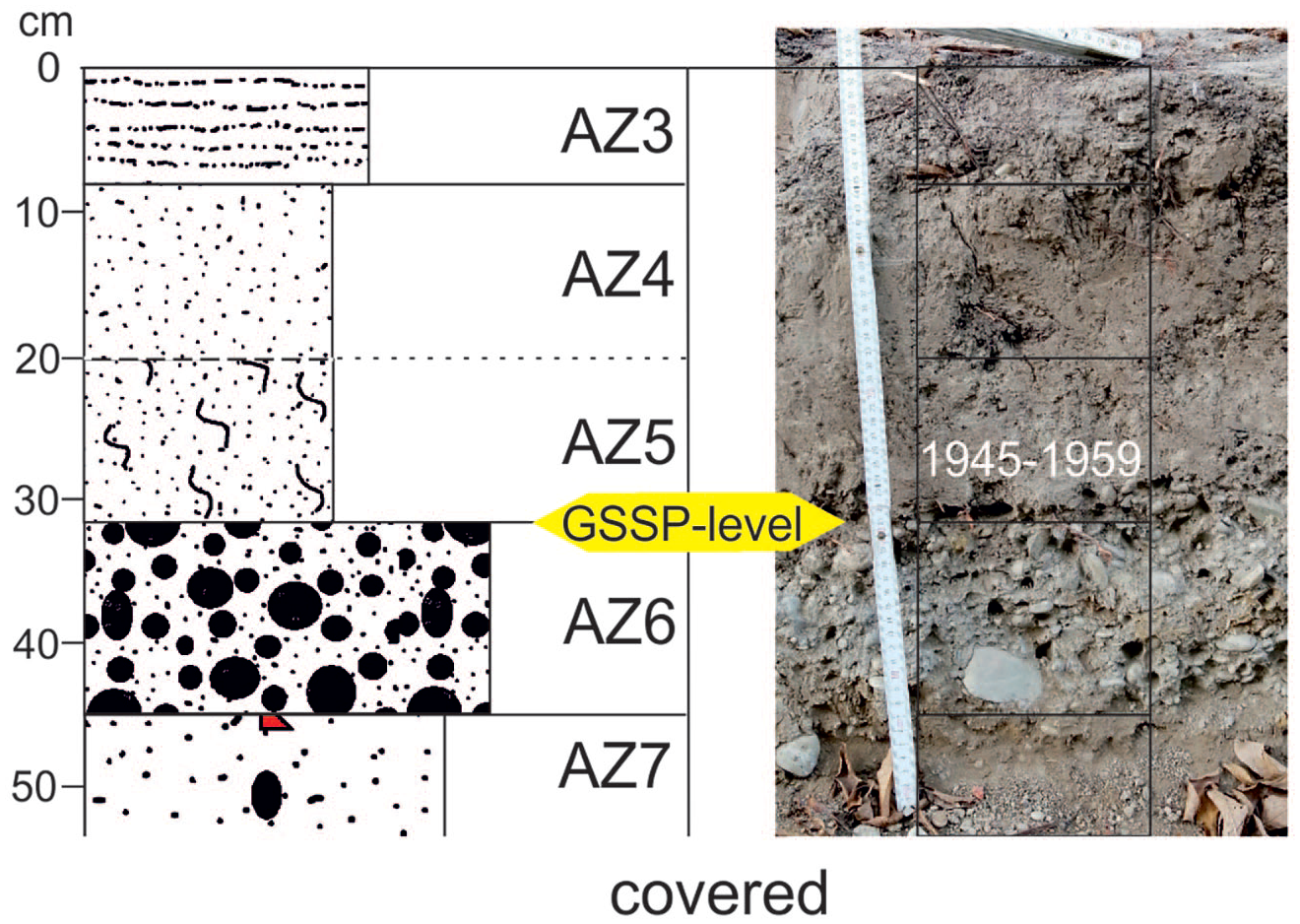
Schematic sedimentological log and in situ section photograph from the Karlsplatz archaeological site. AZ3 denotes the fine-grained top soil, AZ4 sandy silt, AZ5 (fallout marker layer) bioturbated sandy silt, AZ6 sandy gravel, AZ7 gravelly sand. The base of AZ5 is indicated by a yellow arrow as the reference point level. Reproduced in colour in online version.
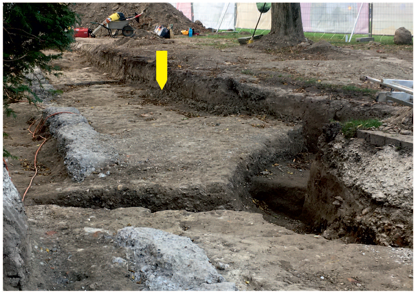
Photograph of the Karlsplatz Wien Museum excavation site, view southwards, Wien Museum to the left. White concrete basement structure of the sales hall (1922), to the left mainly level of the WW2 rubble, to the right (yellow arrow) the main part of the sampled section (samples AZ3–AZ7, see Figure 2). Reproduced in colour in online version.
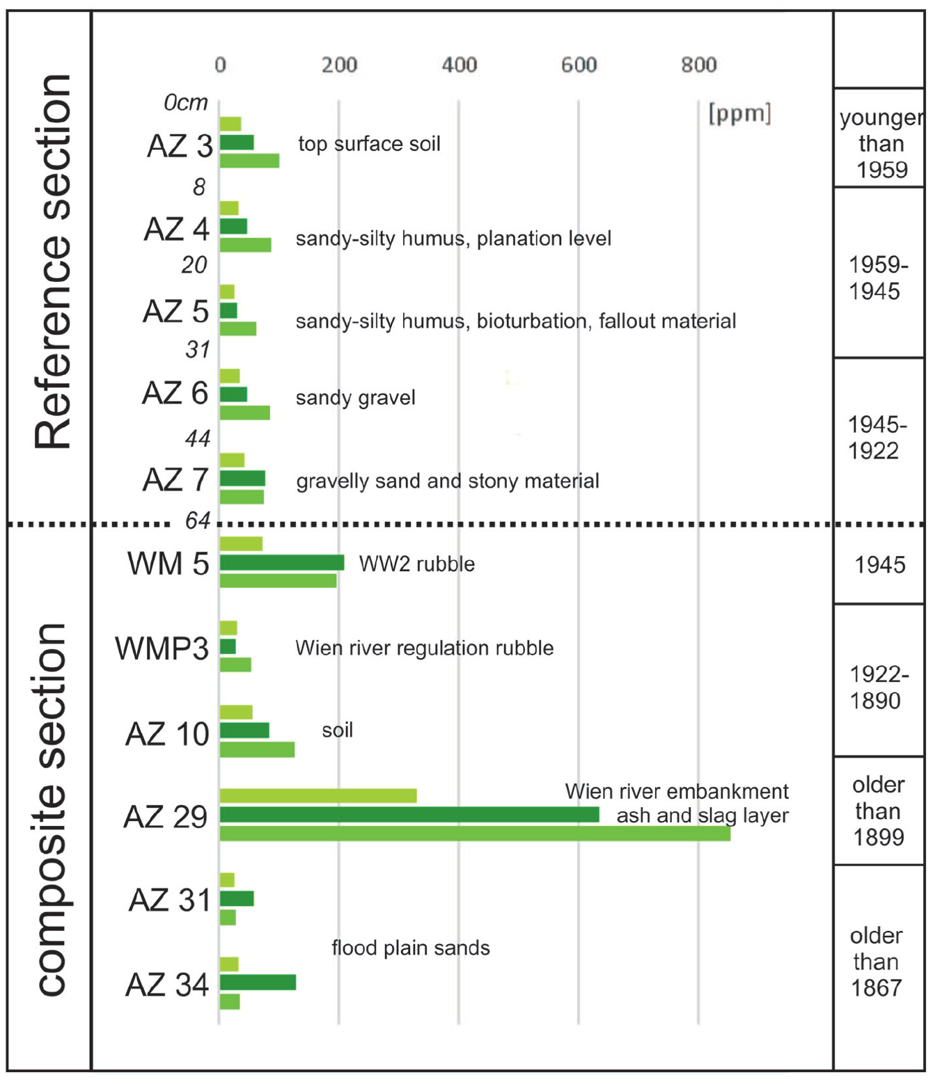
Copper (light green, top), lead (dark green, middle) and zinc (medium green, base) concentrations in ppm of the reference section (upper part of figure, compare Figure 2) and the composite section (lower part of figure). The ages are constrained by historical and archaeological site data. Reproduced in colour in online version.
Further access to the excavated section is hindered by the fact that the investigated area is now used for a deep storage facility of the Wien Museum, so there is no possibility of excavating or coring at exactly the same site. Resampling further to the west of the Wien Museum building may be possible in the future, but needs special permits from the city administration.
The high-resolution archaeological photographic documentation of the site resulted in a 3D-model that is available at the web address (done by Crazy Eye, https://crazyeye.at; https://sketchfab.com/3d-models/grabung-vor-dem-wm-verkaufshalle-1922-1934-ba5206bf380f464bae969cac1026700e).
Chronological controls
The chronological context and controls at the site are based on the pre-excavation historical survey of the building activities in the Karlsplatz area, using historical maps, plans, photographs, paintings and a few borehole logs. This survey predicted probable chronological constraints, including the filling and containment of the Wien River in 1900, the opening of the sales hall in 1922, and the opening of the Wien Museum in 1959. During the excavation, dating of archaeological layers was combined with the survey data (Mosser, 2019; Mosser and Litschauer, 2021), and done using artefacts (technofossils), for example, the layer identified as WW2 rubble included military helmets, insignia, dated coins and toys from the WW2. The overlying levelled layer, finished in 1959, yielded a mixture of artefacts from the 19th to the 20th century, and in the surficial layer recent waste such as polyethylene terephthalate (PET) bottles.
The sequence of layers at the Karlsplatz excavation site and the stratigraphic section is: The oldest road structures date from the 18th century, and are interbedded with some fluvial sands from flooding events by the Wien River (up to 4.2 m below ground surface at 165.93 m a.s.l.). This is followed by road structures of the first half of the 19th century (around 1825), including slag and waste products from metal-working industry. In 1867, the first major regulation of the Wien River was finished, the location of the river bed was redirected, and new roads with cobblestone pavements were built. During 1894–1900, the containment of the Wien River into an underground canal and filling of the natural course of the river with urban rubble took place. From 1922 to 1934 a sales hall (emporium) for luxury goods was located at the site (see basement structures in Figure 3), but it was abandoned and demolished in 1934, resulting in an unbuilt area until the end of WW2. After 1945, groundwork for the Wien Museum started in the 1950s, and the opening of the Wien Museum was in 1959, with planation of the park in front of the Wien Museum.
Anthropocene proxies
Anthropogenic sediments, mostly coarser-grained such as gravelly sands, were sampled focussing on the finer-grained matrix. Visible larger particles, artefacts and technofossils were handpicked for further analyses. About 300–500 g of the finer-grained sedimentary matrix was collected from the freshly opened excavations. Samples were prepared by sieving sediments, with a mesh size of 2 mm to provide a comparable basis for geochemistry analyses of the grain-size fraction finer than 2 mm. Samples for chemical analysis were pulverized in an agate mill (achate) from the sieved and dried fine-grained sediment fraction.
Changes in the geochemistry of this stratal archive, especially for trace metals such as Pb, Cu and Zn, were analysed by X-Ray fluorescence (XRF), using the Philips PW 2404 XRF spectrometer of the Department of Lithospheric Research, University of Vienna, Austria. Samples were calibrated against rock standards (international standards as tabulated by the International Association of Geoanalysts at www.geoanalyst.org) that were physically prepared for chemical analysis following the same methods used for field samples.
Artefacts, used as technofossils to provide age information, were collected during the excavation. However, the mixing of artefacts and sediment from several decades or even centuries was recognized within single stratigraphic units due to the large amount and volume of reworked material in these urban sediments. This hindered a more precise dating of the layers, providing something more comparable to a broad biostratigraphic zone correlation concept (e.g. Remane et al., 1996) than precise geochronological dating.
Detection of anthropogenic marker actinides by AMS
Accelerator Mass Spectrometry (AMS) is an ultra-sensitive ion counting technique for long-lived radionuclides. The advantage of AMS for measuring actinides is the absence of analytical tails from neighbouring masses and the virtually complete suppression of molecular isobars, such as the hydrogen compounds 235UH and 238UH in the measurement of the uranium (U) and plutonium (Pu) isotopes 236U and 239Pu, respectively. The AMS setup at the Vienna Environmental Research Accelerator (VERA) has demonstrated an abundance sensitivity for 236U/238U of about 10−13 (Steier et al., 2019). AMS is a relative measurement technique, which means that the detected radionuclides have to be normalized by isotope ratio measurements. Anthropogenic U isotopes usually are normalized against naturally occurring 238U, with for example 236U measurement results reported as 236U/238U ratios. For the analysis of radionuclides without stable isotopes, that is Pu, americium (Am) or neptunium (Np), a defined amount of another artificial isotope (called a ‘spike’) of the corresponding element has to be added at the beginning of sample preparation. From the measurement relative to the spike an absolute concentration of the radionuclide of interest in the initial sample can be calculated. There is no sufficiently pure isotopic spike available for the mass-spectrometric analysis of environmental 237Np (Hain et al., 2022), so the Pu spike is used for normalisation, leading to higher uncertainties of the final 237Np results.
AMS requires only a few mg of solid sample material for the measurement. The aim of the sample preparation, therefore, is to extract the atoms of interest from several grams of sediment and to embed them in a pure material, usually Fe2O3. A first test measurement on sample AZ5 from Karlsplatz showed that half of the initial sample, that is around 10 g, is sufficient for the detection of the anthropogenic radionuclide signal using the AMS. Similar to the procedures published for marine sediments (e.g. Sakaguchi et al., 2009), also the urban sediments were leached in concentrated HNO3 to extract the anthropogenic actinides, which in general are attached to the surface of the sediment particles. The actinides were then further purified and separated from each other using an established procedure (Hain et al., 2022), based on extraction chromatography which yields a U, a combined Pu and Np, and an Am fraction. From each of the three fractions a solid AMS sample was prepared by Fe(OH)3 co-precipitation of the respective actinide using 2 mg of Fe. The precipitate was calcined at 800°C to obtain Fe2O3 so that the actinides were also prepared as oxides. The Fe2O3 powder was pressed into aluminium sample holders, forming the final AMS sample. Consequently, for each initial sediment sample, three AMS samples were installed into the AMS ion source, that is one for the U fraction, one for Am and one for the Pu/Np fraction of the initial sample. In parallel with the samples, process blanks were also generated from the suprapure chemicals used in the chemical procedure, in order to check for impurities.
Routine actinide analysis at VERA was described in detail previously (e.g. Hain et al., 2020; Steier et al., 2019; Winkler et al., 2015). The actinides of interest, mainly plutonium herein, are extracted from the caesium sputtering ion source as oxide molecular anions, for example PuO−. After a first mass separation, these anions are injected into the tandem accelerator, which is operated at a terminal voltage of around 1.7 MV. In the high-voltage terminal of the accelerator, the ions are stripped to positive charge states in a helium gas and the molecular bindings are broken so that molecular background is efficiently suppressed. This leads to the exceptionally high sensitivities of AMS for trace radioisotopes. After passing additional momentum, energy and velocity filters after the accelerator, for example a 90° dipole magnet, the remaining ions in charge state 3+ are identified by a Bragg type ionization chamber. While the ions of the spike isotopes 242Pu and 243Am are counted in the same detector for normalisation, 238U3+ is measured as a macroscopic beam current. In order to account for differences in the detection efficiency between the current and the count rate measurement and for quality assurance, the analysis of the two 236U in-house standard materials Vienna KkU (236U/238U = (6.98 ± 0.32) ×10−11 (Steier et al., 2008)) and Vienna-US8 (236U/238U = (1.01 ± 0.05) ×10−8) (Shinonaga et al., 2014) are included in the measurement. For the interpretation of the results, the conservative assumption was made that the 236U blank level is equal to, or below, the concentration of the sample with the lowest count rate of 236U events, that is sample WMP3. This approach is in good agreement with the results of the process blanks from which similar count rates of up to 0.004 counts/second were obtained. Correspondingly, the formal blank correction led to an upper limit for the absolute concentration of Pu isotopes in this sample (compare Table 2). As 241Am is produced from Pu in a nuclear device, this radioisotope was only analysed in samples in which a distinct Pu signal above background was detected.
Results
Lithology
The walls and basement of the sales hall built in 1922 form the base of the continuously logged and sampled Anthropocene candidate ‘GSSP’ section (Figure 2). The WW2 rubble, a sandy gravel which fills the remains of these constructions (AZ6 on Figure 2), contains significantly high concentrations of lead, zinc and copper and some traces of plutonium (which may reflect contamination from the formerly exposed rubble surface and/or later sediments). The WW2 rubble, together with the debris from the destruction of the 1922 market hall, are separated by an unconformity from the overlying finer-grained artificial ground and soil that is interpreted as post-WW2. The unconformity is overlain by sandy to silty, humus-rich layers and soil layers with interpreted ages up to 1959, the year of the opening of the Museum when the park area was levelled and recultivated. Increasing upwards in the 1959 soil layer, bioturbation gives the fine-grained sediment a more massive appearance lacking clear layering, with some visible winding tubes up to 5 mm in diameter resembling earthworm structures. Weak solidification of these clay-rich intervals occurs especially after drying.
Mean sediment accumulation rates, although rather arbitrary due to the non-continuous and strongly episodic character of sedimentation, ample signs of reworking and strong lateral thickness changes, are about 0.64 cm/year using the 1922 levelling (which includes AZ3–AZ5 and the thickest part of the WW2 rubble layer), and 0.75 cm/year (AZ3–AZ5) based on the 1945 WW2 rubble top unconformity and the lack of indications of the 1986 Chernobyl event within the section top (Figure 2). For the maximum depth of the excavation (6.30 m) and the corresponding age of the base at the beginning of the 18th century construction of, and around, the Karlskirche, a mean sedimentation rate of about 2 cm/year can be calculated; this higher value is partly due to the significant infilling of the former Wien River channel.
Plastics have been reported during excavation of the WW2 layer (AZ6) and the top part of the section (AZ3 and higher). Due to the possibility of contamination and lack of a clean preparation lab, microplastics have not yet been tested or analysed.
Trace metals
The concentrations of lead, copper and zinc (Table 1) show co-variance, with two peaks within the composite section. The first and most pronounced peak of these three trace metals is within sample AZ29 (Figure 4; Pb 633 ppm, Cu 330 ppm, Zn 852 ppm, Table 1) from the Wien River embankment which is older than 1899 (the last phase of Wien River regulation) and probably older than 1867 (the first major phase of river regulation). It relates to an ash and slag layer from the first half of the 19th century.
Absolute concentrations (in ppm) of the trace metals copper, lead and zinc in the reference and composite Karlsplatz sections. Sample AZ5 denotes the base of the post-1945 levelling layer of the 1950s.
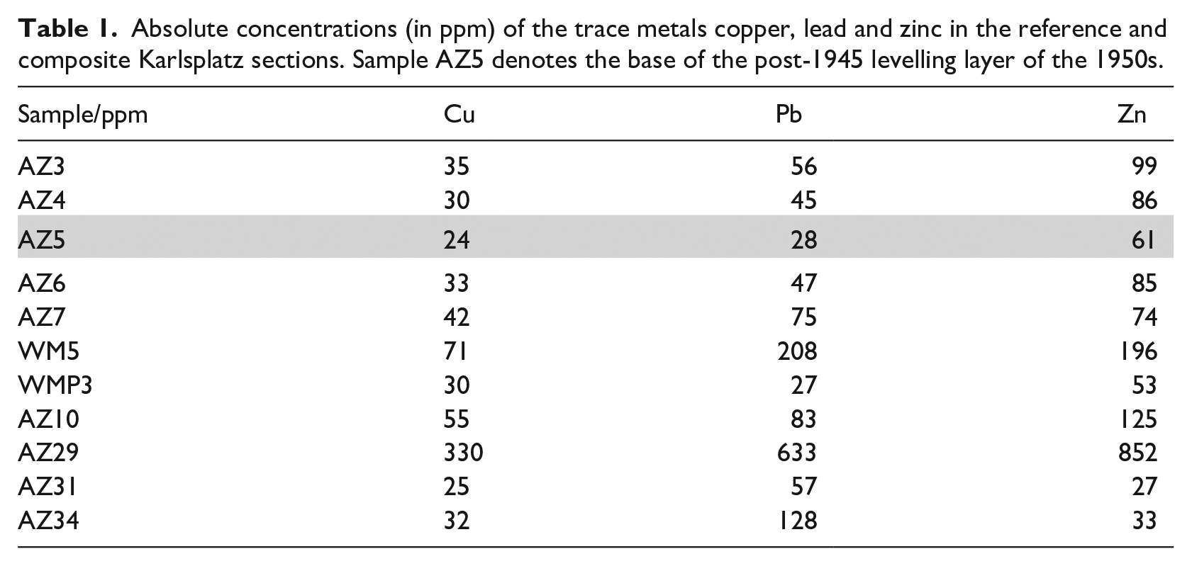
The second peak, not as pronounced as the first one, is noted within the WW2 rubble layer (sample WM5, Pb 208 ppm, Cu 71 ppm, Zn 196 ppm). Values from higher levels, within sample AZ5, show normal mean values that are about one-third of the concentration of WW2 values (Pb 28 ppm, Cu 24 ppm, Zn 61 ppm) and thus show no trace metal peak after 1945. Instead, in the uppermost layer, the active top soil, a slight recent enrichment is marked in sample AZ3 with nearly doubled values compared to the 1950s (Pb 56 ppm, Cu 35 ppm, Zn 99 ppm).
Radioisotopes
AMS analyses of actinides (Table 2) showed a clear signal of high 239Pu and 240Pu concentrations (5.0 × 10⁷ and 1.6 × 10⁸ atoms/g of 239Pu) in samples AZ5 and AZ3. 239Pu as marker signal is also present in the topmost part of the WW2 rubble, however in considerably lower concentration of 8.0 × 10⁶ atoms/g. No Pu signal above background was detected in sediments older than 1922 (sample WMP3).
Concentrations (atoms/g) of plutonium isotopes as well as the 236U/238U ratio which are clearly increasing from the oldest to the youngest layer.
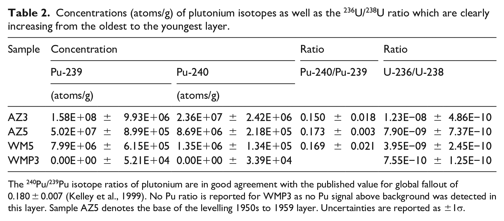
The 240Pu/239Pu isotope ratios of plutonium are in good agreement with the published value for global fallout of 0.180 ± 0.007 (Kelley et al., 1999). No Pu ratio is reported for WMP3 as no Pu signal above background was detected in this layer. Sample AZ5 denotes the base of the levelling 1950s to 1959 layer. Uncertainties are reported as ±1σ.
In addition, an increasing trend from the oldest to the youngest sample was identified for several other artificial radionuclides including 236U/238U, and 237Np (Meszar et al., 2021). For the two youngest layers AZ5 and AZ3 with the highest Pu concentrations, a clear 241Am signal was also detected above background. Isotope ratios such as 240Pu/239Pu (Table 2) and 233U/236U, the latter which was recently introduced as an anthropogenic tracer (Hain et al., 2020), also point to atmospheric nuclear weapons fallout material of the 1950s to 1960s. A significant input of material from the 1986 Chernobyl accident is also considered unlikely in the uppermost sample AZ3 based on the ratio 240Pu/239Pu (Table 2). Published 240Pu/239Pu ratios of 0.408 ± 0.003 (Muramatsu et al., 2000), which have been attributed to the Chernobyl accident, are clearly higher than the ratio assigned to global fallout ratio (240Pu/239Pu = 0.180 ± 0.007) (Kelley et al., 1999), whereas the measured ratio of AZ3 is slightly lower but still in agreement with global fallout within 2σ uncertainty. An in-depth discussion of the radionuclide results and the interpretation of isotope ratios will be published elsewhere.
Technofossils
Technofossils occur throughout the section, and are especially abundant and diverse in the WW2 layer, including entire components and fragments of glass, plastics, ceramics and bricks but also cartridge casings, a German army helmet and guns. However, the ample reworking and re-usage of construction material indicates a strong re-mixture of various older technofossils, including Roman bricks, into the younger layers. Therefore, dating using technofossils is not straightforward and needs careful sampling to find the youngest technofossil from a layer to provide a maximum age.
Discussion
The urban Anthropocene, exemplified by the anthropogenic sediment layers and the section at the Karlsplatz archaeological excavation, Vienna, provides means of stratigraphic correlations and gives information on the suitability of marker signals (Figure 5). The appearance of artificial radionuclide markers, such as 239Pu and 240Pu, in coarse urban anthropogenic sediments of a major capital city as Vienna demonstrates the globally-synchronous appearance of these radionuclides, which makes them exemplary for defining the Anthropocene (chrono)stratigraphically. Thus, the fallout radionuclides were found in the expected artificial soil layer that had been transported to the area until 1959, before the opening of the Wien Museum nearby to the section site. In the rather heterogeneous material the fallout markers show some redistribution, with very low concentrations extending into the 1945 WW2 rubble layer below, caused by radionuclide migration due to illuviation and/or human activity. With the maximum global fallout in the Northern Hemisphere deposited in 1963 (UNSCEAR, 1982), as expected, the top soil layer (younger than 1959) shows the highest radionuclide concentrations. Smaller contributions to the top soil layer at a later date might originate from global fallout which was re-mobilized at other locations and transported to the sampling site. No clear evidence for an admixture of younger radionuclide events, including the Chernobyl reactor accident (1986), was found within the top soil layer.
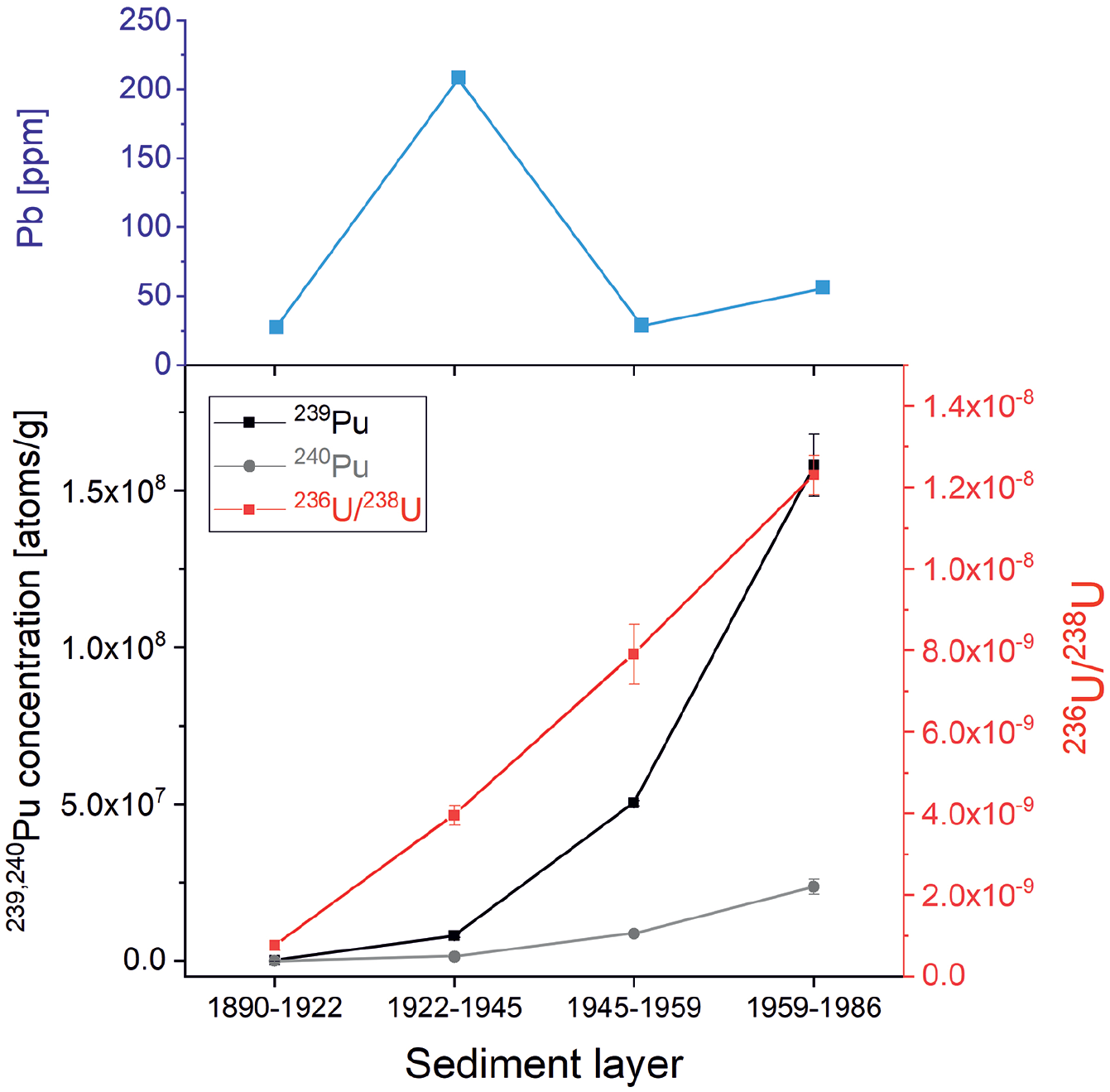
Summary of main marker concentrations of the four time slices archived in the Karlsplatz section and analysed for plutonium isotopes and lead. Uncertainties are reported as ±1σ. Reproduced in colour in online version.
Trace metals show a significantly different distribution, with highest levels in the 19th century in a layer rich in charcoal and ash, and in the WW2 rubble. This indicates strong anthropogenic contamination and local control on the trace metals lead, copper and zinc, as indicated also by the correlation with technofossil (artefact) findings such as slag remains and cast iron hardware from nearby cast iron manufacturers, active from 1750 to 1851 and 1872, respectively (Mosser, 2019; Mosser and Litschauer, 2021). The second peak in trace metals derives from the WW2 rubble, where artefacts including a German army helmet and Nazi insignia and other similar technofossils were found. These very local trace metal contaminations surpass the background values 3–10 times, but the suggested base layer AZ5 of the Anthropocene shows no significant trace metal accumulation, also owing to its origin as a transported layer of soil and humus for the park area developed in front of the Wien Museum. Similarly, the technofossil content of this layer is rather suppressed and negligible due to probable sieving and manual sorting of this 1950 humus. Only in the topsoil, plastic becomes a more wide-spread component and trace metals show a mild enrichment, which may correlate to the gasoline lead peak of the 1960s to 1970s (e.g. Gałuszka and Wagreich, 2019).
The requirements for a GSSP broadly relevant to the Quaternary System are indicated by Head and Gibbard (2015). The GSSP section should provide the best possible record of the relevant marker events, and especially the primary event, in an exposure over an adequate thickness of sediments, but also any relevant auxiliary markers, in order to achieve maximum correlation potential (italics cited following Head and Gibbard, 2015). The data from the Karlsplatz section suggest the primary marker be the correlation of the fallout radionuclides, especially the 239Pu and 240Pu concentrations and ratios. Secondary markers are trace metals such as lead, copper and zinc and various technofossils including plastics, glass fragments, bricks, but due to local sources and ample reworking, these signals do not form clear markers and cannot be correlated more regionally. Concerning plastics, it has to be noted that synthetic material was already used during WW2 times, and for precise dating, a closer look on the types of plastics to infer a detailed plastic stratigraphy is essential (Zalasiewicz et al., 2016).
The thickness of the reference section of about 60 cm is adequate to resolve the Holocene-Anthropocene transition; however, sedimentation is highly episodic, marked by severe unconformities between more rapidly deposited ‘event’ layers (e.g. the WW2 rubble ‘event’), with common reworking and redistribution of these artificial sediments and soils. Mean sediment accumulation rates are in the range of 0.6 cm/year, but rather meaningless due to the episodic nature of the deposition. Due to the anthropogenic reworking, anthroturbation in the sense of Zalasiewicz et al. (2014), and the resulting extremely heterogeneous and strongly disturbed layering, unambiguous interpretation of the sedimentary sequence both vertically and laterally is difficult to achieve. Instead of fossils, various kinds of (correlatable) technofossils were found and allow more precise correlations when analysed in detail, such as WW2 material. Due to the nature of these artificial sediments, the base of the Anthropocene in the section at the base of bed AZ5, and thus the potential ‘Golden Spike’, shows an unconformity and lithological change from a gravel to a finer-grained soil that was surely transported to the site a few years later. This is a sign of a major paleoenvironmental perturbation as noted critically for GSSPs by Head and Gibbard (2015).
The necessary direct quantitative calibration with dating is achievable in a resolution of decades by historical (such as photographs of the area of the section) and archaeological/technofossil evidence. Methods such as magnetostratigraphy and astrochchronology are not applicable, but a calendar decade historical dating is possible. Intensive research was performed in and around the section, including detailed archaeological stratigraphical and chemostratigraphical methods.
Accessibility and protection of the Karlsplatz site poses a further problem physically, as the section was excavated for the foundation of the deep storage facility in front of the Wien Museum, therefore the section itself is no longer accessible, only documented by photographs and a 3D model. Re-sampling of the section is therefore not possible due to the cover by a building. However, coring nearby in front of the building would be possible given permissions from the municipality of Vienna.
Based on the criteria as noted by Head and Gibbard (2015), and unlike other proposed GSSP sites for the Anthropocene, the Karlsplatz site cannot be a candidate GSSP, since it does not fulfil major criteria needed to define the lower boundary of a geological epoch, as specified by the International Commission on Stratigraphy (e.g. Remane et al., 1996). Importantly, because the investigated samples are urban deposits – including rubble from World War 2 and anthropogenic soils – there is no continuous record as required for a GSSP. There are rarely annual layers in anthropogenic sediments since deposition rates are usually highly variable, and mixing as well as redeposition is common. Further, because the site will be overbuilt, preservation and future sampling will be hindered.
However, the Karlsplatz site can be used as a reference section for the Anthropocene, as the stratigraphic markers and technofossils in the urban rubble contain signals that have potential correlations with findings from other GSSP sites, including the fallout radionuclides such as plutonium, the trace metal concentrations, although strongly locally affected, and the technofossil record.
Footnotes
Funding
The author(s) disclosed receipt of the following financial support for the research, authorship and/or publication of this article: This work was supported by the Vienna Science and Technology Fund (ESR17-040), Wien Museum, and the UNESCO International Geoscience Program (IGCP 732).