
Abstract
We review and compare proposals for 12 reference sections submitted to the Anthropocene Working Group of the International Subcommission on Quaternary Stratigraphy, of which one will be recommended as the Global boundary Stratotype Section and Point (GSSP) to define the base of the Anthropocene as a series within the Geological Time Scale. The sites span five continents and are located in diverse environments, with all but one sampled by coring. Many sites show annually resolved laminae (here considered optimal for GSSP selection) that can be independently dated radiometrically to confirm a complete succession over the critical interval. An extensive range of proxies, documenting profound human modification of the Earth System at around the mid-20th century interval, has been analysed. Airborne signals (e.g. radioisotopes, fly ash, stable carbon and nitrogen isotopes) provide the most widespread and near-isochronous proxies, applicable across most environments. Additional means of correlation include the appearance of microplastics and persistent organic pollutants, and shifts in heavy metal concentrations and lead isotope ratios. Assemblage changes of microfossils (and some macrofossils) in marine, estuarine and lake settings reflect environmental changes and biological introductions. These systematic and comprehensive datasets, with correlation established between sections, provide the basis for a proposal to formalize the Anthropocene.
Introduction
The Anthropocene Working Group (AWG) was established as a task group in 2009 by the Subcommission on Quaternary Stratigraphy (SQS) to assess evidence for the potential suitability of an Anthropocene chronostratigraphic unit and, if found suitable, propose to the SQS its definition (Zalasiewicz et al., 2017, in press). The AWG initially addressed: whether the Anthropocene possessed geological ‘reality’; the most suitable timing of its beginning; the hierarchical rank the unit should have and by which means it should be defined (Waters, 2019). Regarding the last of these, two types of stable reference point may provide formal definition of a unit in the Geological Time Scale: a numerical age known as a Global Standard Stratigraphic Age (GSSA), based on an agreed date and currently restricted to the Precambrian; or a physical boundary known as a Global boundary Stratotype Section and Point (GSSP, colloquially known as a ‘golden spike’).
Zalasiewicz et al. (2015a) suggested an Anthropocene boundary defined by a GSSA based on the precise time of the world’s first nuclear detonation of the Trinity A-bomb on July 16th 1945 at Alamogordo, New Mexico. This exact moment resulted in the first local dissemination of bomb-produced radionuclides, though Waters et al. (2015) suggested that a globally distributed fallout signal would relate to the first detonations of thermonuclear (fusion) devices in 1952 and be more practically correlatable. An alternative ‘neutral’ date for a GSSA of 1950 was also suggested by Zalasiewicz et al. (2015a), reflecting the timing of the Great Acceleration (Steffen et al., 2007, 2015) and with some geological resonance in that radiocarbon dates have been commonly quoted as ages relative to BP (before present), taken as 1950. No precedent exists for a chronostratigraphic unit in the Phanerozoic Eon to be defined formally by any means other than a GSSP, but potentially Anthropocene-relevant modifications have been made, such as accepting that the timing of the Cretaceous/Paleogene boundary should reflect the moment of impact of the Yucatan bolide and not the age of the accumulated ejecta (Molina et al., 2006), and effectively assigning a date of 4250 years before 2000 CE (b2k) for the Meghalayan GSSP (Walker et al., 2018).
In 2016 the AWG reported their majority agreement that the concept of the Anthropocene is stratigraphically real (34 for, 0 against, 1 abstain), should be formalised as a chronostratigraphic unit (29 for, 3 against, 3 abstain), that the optimal boundary level aligns with the mid-20th century based on substantial evidence as described below (28.3 for, 2.6 preferring other levels and 4 preferring a diachronous informal unit), that epoch status is most appropriate (20.5 for, 6.5 preferring alternatives, 1 preferring none, 4 abstain) and that the group should work towards such a proposal (Zalasiewicz et al., 2017). The vote recommended, too, that the AWG follow the GSSP route (25.5 for, 1.5 preferring GSSA and 8 uncertain) as this is the most familiar and widely accepted method of defining formal chronostratigraphic units in the Phanerozoic.
In 2019 the AWG held a binding vote, which recommended by supermajority of 29 votes for and 4 against on both proposals (AWG, 2019): (1) defining the Anthropocene as a formal chronostratigraphic unit within the International Chronostratigraphic Chart (ICC, Cohen et al., 2013), which serves as the basis for the international Geological Time Scale (GTS) and (2) that the primary guide for the base should be one of the stratigraphic signals in the mid-20th century (Zalasiewicz et al., 2020).
Since 2019 there has been a concerted effort to provide multi-proxy assessments of a number of potential GSSP sites and other reference sections around the planet (Figure 1; Table 1), in a unique analytical programme enabled by Berlin’s Haus der Kulturen der Welt (Rosol et al., 2023). The 12 publications contained in this thematic set present the results of these studies. Some sites had been fully or partly analysed prior to 2019, with any missing key markers being subsequently determined by an AWG-coordinated programme of analysis, and a few had been studied entirely independently of this coordinated study. The site analyses were guided by, but are independent of, the AWG, though many AWG members were involved in one or more studies.
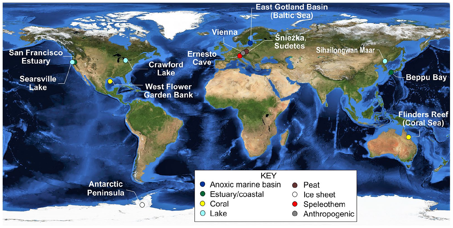
Location of the 12 candidate and other reference localities indicating the depositional environment. Satellite image: NASA visible earth.
The core codes, locality names and environments of the 12 candidate and other reference sites, listing the core/site altitude at time of collection, the full core length and length of that part that is deemed to be Anthropocene in age (with recommended date – see Table 4) and the relevant reference in this thematic set.
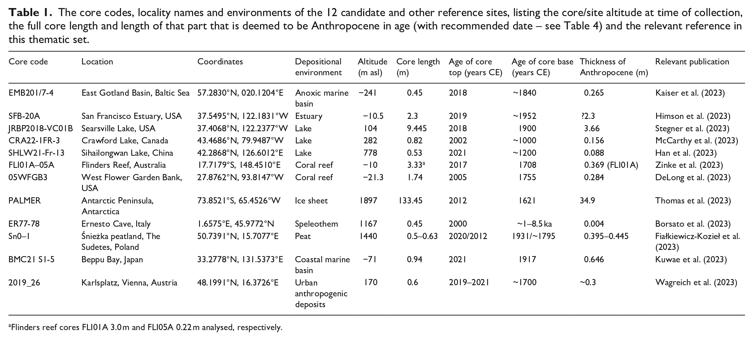
Flinders reef cores FLI01A 3.0 m and FLI05A 0.22 m analysed, respectively.
Each study provides a comprehensive, data-rich description of a single site, describing all the proxies analysed (including those with incomplete or imprecise results). The full datasets are provided in the Supplementary Information for each site. The teams were asked to recommend what they consider to be the primary marker at their respective site and from this to suggest the most suitable GSSP level. To facilitate comparison among sites, each publication follows a consistent format and describes the following: (1) strength of the chronology; (2) whether there are potential hiatuses or reworking/bioturbation; (3) timing and abruptness of the different signals; (4) how the various proxies may relate to known social/landscaping/industrial activities or climatic/flooding events; and (5) the extent to which there is consistent alignment within their site of the proxies and how they relate to the mid-20th-century agreed base of the Anthropocene. Some sites were ultimately deemed by their authors as unsuitable to serve as GSSPs but are included in this special issue as potential reference sections.
The descriptions provided in this thematic set comprise the main source of information for voting members in the selection process. By producing these articles in a consistent style, such members would more easily: (a) decide the preferred rank (series/epoch has not yet been agreed by binding vote) and (b) recommend which (if any) of the sites should be proposed to SQS as the GSSP, and additionally consider auxiliary sites. Subsequently, a single formal proposal for formalisation will be compiled for submission to the SQS management team.
Decisions require supermajority (60% or more) voting outcomes, first by voting members of the AWG, which leads to a formal recommendation, followed by voting members of the SQS to endorse the proposal, and then by the voting members of the ICS (three voting executive officers and all chairs of the 16 subcommissions) to approve the proposal. Final ratification by the International Union of Geological Sciences (IUGS) Executive Committee (EC) requires assurances that ICS policies and procedures have been followed (Finney, 2014). No single step in this process guarantees success. Once ratified, a GSSP provides a stable reference: it cannot be subsequently modified for at least 10 years (Remane et al., 1996). The exact stratigraphic position chosen (the ‘point’ in the GSSP) remains the reference point, even if the key marker is later found to have appeared elsewhere in the stratal succession at the same location.
Evidence for an Anthropocene series/epoch commencing in the mid-20th century
The AWG initially needed to assess whether the Anthropocene has merit as an official GTS unit and if so to then build a geological description, and in particular to decide upon a primary guide by which to locate its potential lower boundary. Widely differing ages for the onset of the Anthropocene have been proposed, each in turn receiving consideration by the AWG. Proposals include aligning with the latest Pleistocene megafaunal predation and vegetation change (the Late Quaternary Extinction) (Doughty, 2013) or with the Early Holocene (11–9 ka BP) emergence of significant human niche construction such as urbanism, agriculture and pastoralism (Smith and Zeder, 2013). In both cases, the effects noted are associated with several distinct centres and are highly diachronous and as such are unsuited for defining an isochronous chronostratigraphic boundary; hence neither plays a role in defining formal units for the Late Pleistocene and Holocene. Reversals in the falling trends for atmospheric CO2 from about 7 ka BP (arguably through deforestation) and for CH4 from 5 ka BP (through increased wet-rice farming and livestock production) were the basis of an ‘early anthropogenic hypothesis (EAH)’ by Ruddiman et al. (2020), with the advantage of being globally distributed and abrupt and hence more suited as a chronostratigraphic boundary. However, Zalasiewicz et al. (2019a) noted studies questioning the anthropogenic origins of the slow CO2 rise and suggesting that the oceanic CO2 reservoir contributed much of the increase, with such slow upturns also recorded in the interglacials MIS 11c and MIS 15e (~400 and ~600 ka respectively). In particular, Zalasiewicz et al. (2019a) noted that: it was important not to conflate anthropogenic activity and the Anthropocene, the latter not representing initial human impact, but a planetary response to later, overwhelming human impact, and that mid-20th century changes emphatically mark a major departure. A similar proposal by Lewis and Maslin (2015) was for a 1610 CE ‘Orbis’ date which reflects a short-lived decline in atmospheric CO2 of ~10 ppm which they associated with depopulation in the Americas following European colonisation, forest regrowth and resultant CO2 uptake. However, Zalasiewicz et al. (2015b) noted that this marker is problematic stratigraphically, being only observed in ice core records, that it is insignificant with respect to the entire Holocene record, that the anthropogenic origin of the dip has been questioned, and that it is dwarfed by the more substantial perturbation of atmospheric CO2 concentrations in the mid-20th century.
When introducing the term Anthropocene, Crutzen and Stoermer (2000) and Crutzen (2002), working within the Earth System science (ESS) community, proposed the beginning of the Industrial Revolution in Europe, with the introduction of Watt’s improved steam engine. This technological breakthrough led to changes in greenhouse gas concentrations in the atmosphere through increased burning of fossil fuels. However, the resulting geological effects were gradual and varied in time and space, leaving no single clear isochronous signal in the geological record. The ESS community, in continued assessment of the Anthropocene, identified an array of global and near-synchronous signals ~1950 CE, reflecting abrupt changes of socio-economic factors, biophysical processes and consequent environmental and climatic change. This was termed the ‘Great Acceleration’ and was coincident with, and driven by, unprecedented increases in population, energy consumption, industrialisation and globalisation following the end of World War II (Steffen et al., 2007, 2015). These studies considered data from the mid-18th century onwards, but an equivalent analysis for the past 12,000 years (Syvitski et al., 2020) found the fundamental drivers of change and consequent global effects to be highly correlated and show steep increases in growth at around 1950 CE. The Great Acceleration, reappraised, is shown to provide a quantitative basis for an Anthropocene series/epoch (Head et al., 2022a).
The AWG initiated wide-ranging assessments of the physical (lithostratigraphic), chemical (chemostratigraphic) and biological (biostratigraphic) signals that might justify an Anthropocene chronostratigraphic unit, compiling several thematic volumes exploring its geological nature and meaning (Waters et al., 2014; Williams et al., 2011; Zalasiewicz et al., 2019b) and contributing to the Geological Time Scale 2020 (Zalasiewicz et al., 2020). These studies concluded that the Anthropocene is significant at geological scale because of the rapidity and magnitude of its impacts, many of which have brought irreversible change. An important range of proxies of anthropogenically-driven change, coincident with the Great Acceleration curves, were recognised in geological strata. These include novel markers associated with radionuclides from above-ground nuclear detonations (Waters et al., 2015), fly ash (Rose, 2015), microplastics (Zalasiewicz et al., 2016), fundamental indicators of carbon-nitrogen-sulphur cycle changes such as nitrogen isotopes and diatoms (Wolfe et al., 2013) and biodiversity changes involving species losses, translocations of species and expansion of domesticated species (Williams et al., 2022). A summary of the identified patterns (Waters et al., 2016) clearly showed that that the presence and/or magnitude of these proxies departed from the range of Holocene variability, hence justifying the Anthropocene at series/epoch rank.
A further proposal by Gibbard et al. (2021, 2022) suggested that the Anthropocene should represent an informal diachronous ‘geological event’ rather than a formally defined chronostratigraphic unit. This interdisciplinary concept described the Anthropocene as encompassing up to ~50 ka of transformative human cultural and societal impact. In response, Head et al. (2022b, 2022c) and Waters et al. (2022) noted that while this ‘event’ recognised important early phases of anthropogenic activity, it overlooked and in effect minimised the overwhelming human modifications seen in the mid-20th century. They also argued that Gibbard et al. (2021, 2022) provided a non-standard interpretation of an event, which is typically brief certainly by Quaternary norms; and that the recognition of events and chronostratigraphic boundaries need not be mutually exclusive. Waters et al. (2022) summarised the numerous events centred on the mid-20th century (termed the Great Acceleration Event Array) which will assist in globally correlating the chronostratigraphic boundary.
Criteria for selection of a good GSSP
Established stratigraphic procedures for deciding on a GSSP have been described by Salvador (1994), Remane et al. (1996) and Remane (1997, 2003). A GSSP usually requires: (1) a physical stratigraphic marker to enable precise visual recognition locally and (2) at least one primary stratigraphic marker (i.e. a proxy signal, such as a geochemical change) facilitating global correlation. The GSSP should have an exemplary record of this primary stratigraphic marker, although other signals should be present to assist in correlation where the primary stratigraphic marker is not present. The GSSP may be supported by one or more standard auxiliary boundary stratotypes in which the same interval is represented by similar or other proxy signals in different facies and in other parts of the world (Head et al., 2023a, b). The GSSP alone, however, fixes the position of the chronostratigraphic boundary.
An effective checklist of ideal requirements for a GSSP (see Table 2) applicable to the Quaternary is based on Head and Gibbard (2015). Not all requirements need be met.
Requirements for a GSSP based on Remane et al. (1996) and Head and Gibbard (2015), with comments relevant to the Anthropocene as an epoch/series and on suitability of specific sites.
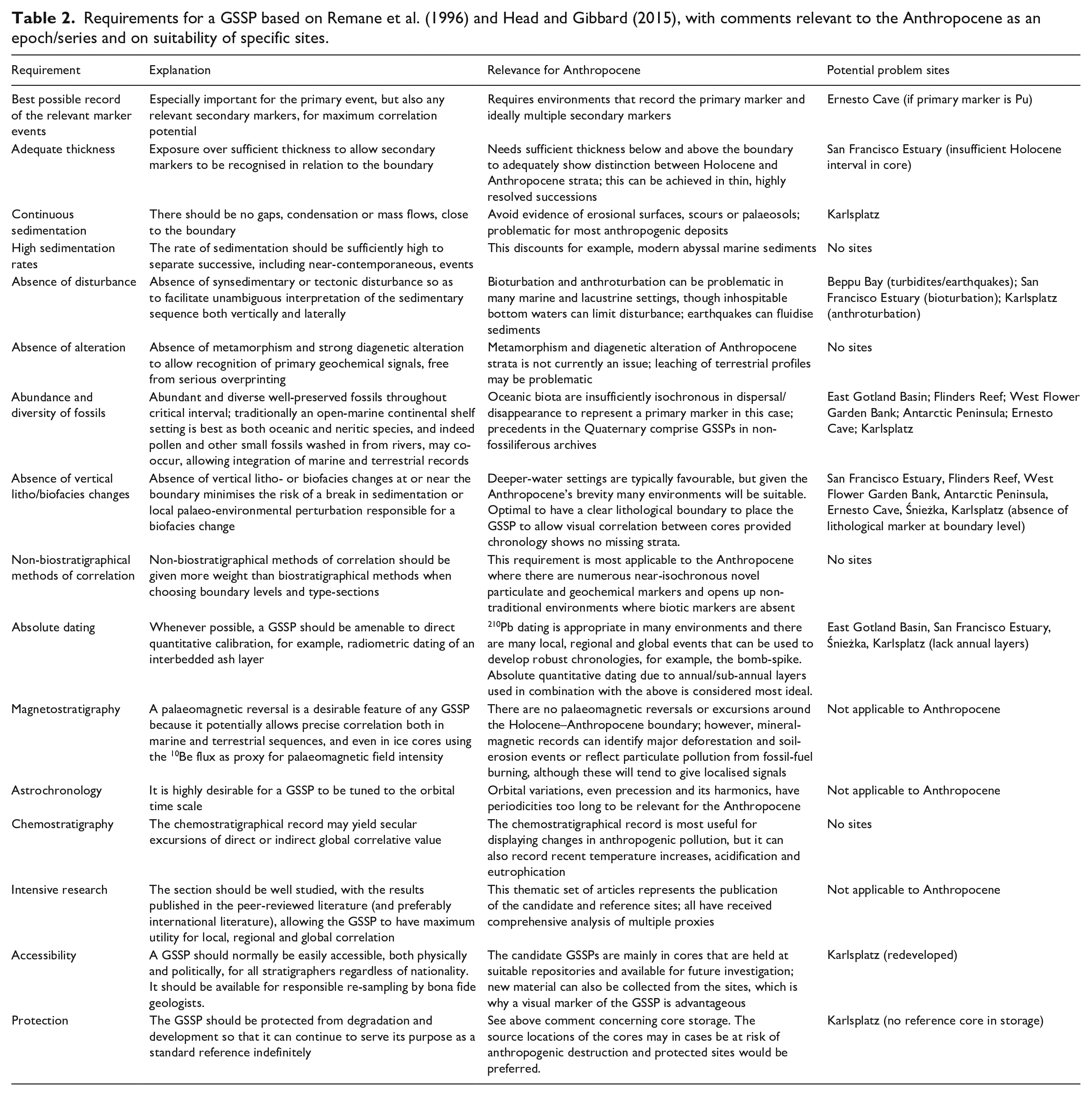
Along with the supermajority AWG decision in 2019 to seek a GSSP defining the base of the Anthropocene series (AWG, 2019), initial review helped establish the most suitable environments and potential locations for such a stratotype (Waters et al., 2018). Although GSSPs in general do not require numerical dating (Table 2), high-precision dating of some kind for the Anthropocene seems necessary to establish maximum synchroneity of correlative signals, and provide confidence that no strata are missing.
The most robust dating (Waters et al., 2018) comprises annual resolution in seasonally layered archives in which layer counting can be supported by radiogenic dating techniques (e.g. 210Pb dating) or unambiguously historically dated events. Examples are varves in anoxic marine basins and meromictic lakes, annually laminated speleothems, annual growth increments in corals, bivalves and trees and annual glacial ice layers. Nonetheless, Waters et al. (2018) also recommended consideration of other environments that lack clear annual laminae (Table 2), such as anthropogenic deposits and ombrotrophic peat bogs, which contain useful signals at high resolution.
Review of the candidate GSSP and other reference locations
Most GSSPs throughout the geological column are within marine strata and, given that the oceans cover ~70% of the Earth’s surface, it was considered important to have at least one marine reference site. However, accumulation rates in large parts of the deep ocean are too slow to have developed a meaningful thickness of Anthropocene sediments, while continental shelf and slope deposits are prone to disturbance through bioturbation and anthroturbation by trawler fishing, and slope settings may be affected by sediment remobilisation (Waters et al., 2018; Table 2 herein). Waters et al. (2018) therefore suggested undisturbed marine anoxic basin deposits as most suitable, and two of the candidate GSSP sites are within such an environment.
The East Gotland Basin is a deep anoxic basin within the largely enclosed Baltic Sea (Kaiser et al., 2023). The single sediment core EMB201/7-4 shows a clear colour change at ~27 cm depth (1956 ± 4 CE), with homogeneous grey silty clay with low organic carbon content below and brown to black, organic-rich sediments above. Although laminated, the succession lacks annual varves. The colour change coincides with an increase in nitrogen and phosphorus input to the Baltic from agricultural discharges, resulting in the expansion of anoxia. The chronology is largely determined through event stratigraphy, including the appearance of dichlorodiphenyltrichloroethane (DDT), known dates of major Baltic inflows of oxygen-rich waters from the North Sea (which produce manganese carbonate horizons) and the 1986 CE Chernobyl event. Key proxies showing significant changes at or close to the proposed base of the Anthropocene at the lithological change include (Table 3): increased concentrations of DDT, spheroidal carbonaceous particles (SCPs), microplastics (MPs), total carbon and total nitrogen (TN), organic content (TOC), heavy metals and mercury and δ13C transition to less negative values. The initial upturn in 239+240Pu and 241Am occurs at 27.3 cm depth (1953 ± 4 CE), just below the lithological transition.
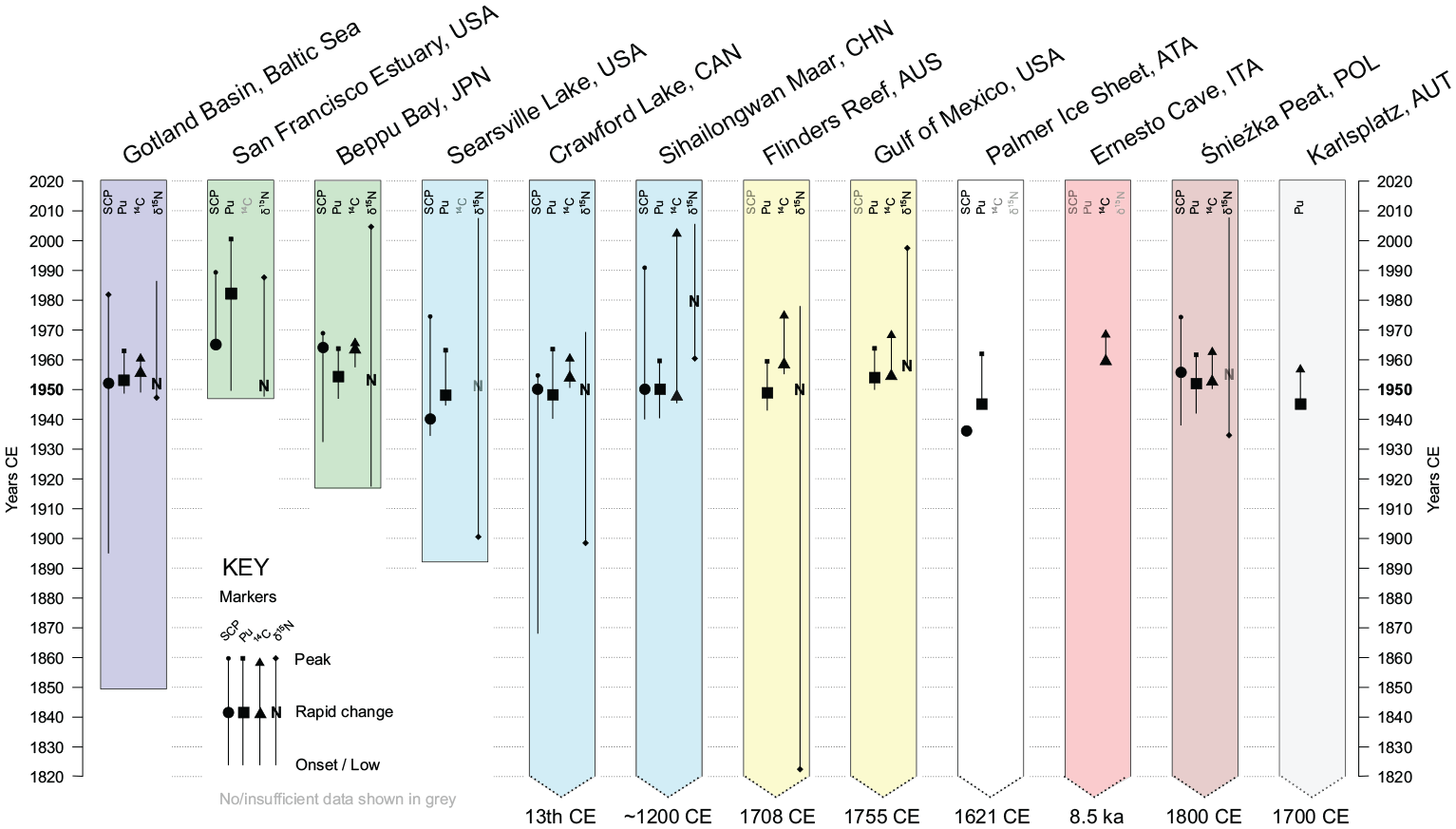
The range of stratigraphic markers investigated at the 12 candidate GSSP and other reference sites, with indication of the date (in years CE) that these proxies show most abrupt change.
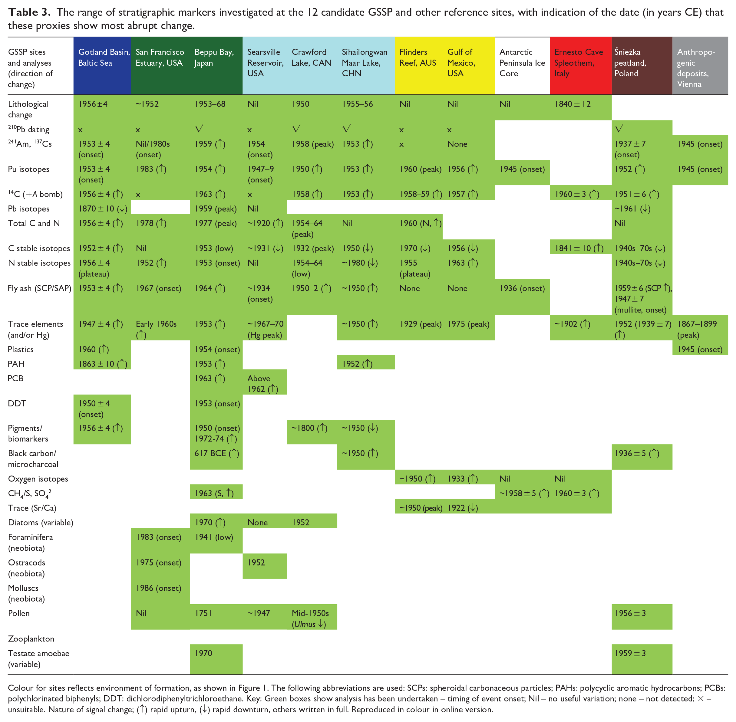
Colour for sites reflects environment of formation, as shown in Figure 1. The following abbreviations are used: SCPs: spheroidal carbonaceous particles; PAHs: polycyclic aromatic hydrocarbons; PCBs: polychlorinated biphenyls; DDT: dichlorodiphenyltrichloroethane. Key: Green boxes show analysis has been undertaken – timing of event onset; Nil – no useful variation; none – not detected; × – unsuitable. Nature of signal change; (↑) rapid upturn, (↓) rapid downturn, others written in full.
The second marine site is within an isolated basin located in relatively shallow coastal waters of Beppu Bay, Japan (Kuwae et al., 2023). It differs from the East Gotland Basin site in displaying annual varves and numerous turbidite layers. The study has a comprehensive analysis of 99 proxies determined from numerous cores from five sites, with the candidate GSSP core BMC21 S1–5 including Pu analysis. A colour change at the top of the 1953 CE flood layer coincides with a change from weaker-laminated and higher-density pale olive-green sediments below and finely laminated, lower-density black sediments above. The chronology is largely determined through varve counting supported by 210Pb and 14C dating, with event stratigraphy, including the known dates of: typhoon resedimentation events at three levels (1964, 1993 and 2004 CE); flood events at 13 levels between 1949 and 2017 CE; and the 1968 Hyūga-nada earthquake event. The event chronology is further supported by consistency with the radionuclide bomb-spike and Fukushima Daiichi event in 2011 CE. The proposed base of the Anthropocene is at the base of a visible flood event layer at 0.646 m (1953 CE) that coincides with a slight increase of 239+240Pu as a primary global marker, and of 137Cs, as well as with unprecedentedly high values of δ15N of anchovy fish scales for the last 290 years and heavy metal concentrations (e.g. Pb, Hg, As) for the last 1300 years. A little above, at 0.60 m depth (1954 CE), there is a prominent Pu upturn (and again in 1959 CE consistent with post-moratorium increase in fallout), the appearance of microplastics (1954 CE) and initial increase in PAHs (1953 CE). Higher in the core are prominent changes to Pb stable isotopes (1959 CE) and increased concentrations of PCBs (1963 CE) and SCPs (1964 CE), whereas the secondary lithological change at 0.48 m depth (1968 CE) approximately signals shifts in diatom and palynomorph abundance and zooplankton-derived pigments (1970–1974 CE) (Table 3) which are associated with the start of intense eutrophication.
River estuaries record evidence of anthropogenic impact of the entire catchment, but can be prone to bioturbation and gaps in succession (Waters et al., 2018). The San Francisco Estuary has a well-documented history of invasive species, these showing considerable promise for high-resolution biostratigraphy in core successions. The study by Himson et al. (2023) shows the reference core SFB-20A to be unlaminated and homogeneous except for two sandy layers that are believed to reflect El Niño events in the 1950s and 1980s. Only the upper part of the 210Pb model was considered robust but deviated from timings of known events. Furthermore, the radiocarbon and plutonium bomb-spike is evident but with atypical profiles, yielding an uncertain chronology in which the base of the core is estimated at ~1952. Both mercury and SCPs show elevated levels in sediments interpreted as deposited in the 1960s (Table 3). Five introduced species were recorded from 1975 CE, their relative appearance matching the pattern in other cores taken in the Bay: two Japanese ostracod species, an Atlantic coast ostracod, a Japanese foraminifer and a Chinese mollusc, the latter coinciding with the 1982–1983 El Niño event.
Lake successions can include seasonal varves, particularly in deep glacial and volcanic crater (maar), meromictic (including hypoxic) or saline lakes, the last of these being more prone to drying out and loss of lamination (Waters et al., 2018). Small deep glacial scour and maar lakes that lack feeder streams are advantageous for receiving direct atmospheric deposition and thus the varves record regional and global signals. Three lacustrine successions, with distinct origins and relationships to pollution events, have been studied.
Firstly, the Searsville Lake, California records sedimentation initiated in 1892 CE through dam construction, the river outflow being close to, and effectively upstream of, the San Francisco Estuary site (see above). The study by Stegner et al. (2023) reveals a layered lake sediment succession of silts/clays reflecting regular, seasonal deposition. The study is based upon the main reference core JRBP2018-VC01B, with microfossil data from a nearby closely correlated core. Both 210Pb and 14C models proved unsuitable and the chronology is determined using layer counts tied to event stratigraphy, including the known dates of: 1906 and 1989 earthquakes recognised in the core; first documented use of CuSO4 as an algicide in 1943 and again in 1952 and 1953; and the bomb-peak of 137Cs in 1963. Additional key proxies showing significant changes at the proposed base of the Anthropocene in the fall of 1948 include (Table 3): onset of the bomb-peak in 239+240Pu, slightly preceded by the first appearance of SCPs, first increase in Pb concentration, first declines and increased variance of stable carbon isotopes, and a major turnover in ostracods after 1952; and succeeded by peak Hg during 1967–1970 and Pb in 1970 and 1985 CE.
The Crawford Lake, Ontario site, discussed by Waters et al. (2018), is detailed by McCarthy et al. (2023) with new data from five cores collected in 2019. Originally investigated to demonstrate the sporadic occupation by pre-European indigenous peoples and subsequent colonisation by Europeans, the new study has provided a wider range of proxies (not just those indicative of agricultural change) and a more detailed investigation of the younger part of the succession. The succession since the time of indigenous settlement has produced distinct seasonal varves comprising pale calcite and dark organic laminae. The varve representing the preferred age of 1950 CE occurs ~8 mm below a distinctive triple cluster of pale laminae. This is closely coincident with the rapid rise in 239+240Pu and SCPs between 1949 and 1954, low δ15N from 1954 to 1964 and major ecosystem change in siliceous microfossils in 1952 (Table 3). The proposed GSSP core CRA22-3-1FR was collected in 2022 in which Pu, radiocarbon, 210Pb, 137Cs, 241Am and SCP analysis is being undertaken to compare with the existing data.
The Sihailongwan Maar Lake, China succession described by Han et al. (2023) comprises varves of clastic silt and clay (winter) interlaminated with layers of algae and organic matter (summer–fall). Varve counting produces a robust chronology corresponding with radiometric (210Pb, 137Cs) dating. Analytical work was carried out on nine cores, from a total of 28 that were collected, with SHLW21-Fr-13, from which the 239+240Pu data were analysed, being the GSSP candidate. The proposed succession extends back to ~1200 CE. A prominent colour change occurs from lighter to darker laminae at a depth of 85 mm (1955–1956 CE). A very distinct pale marker layer in these upper darker laminae occurs at ~60–62 mm (~1977–1978 CE). The preferred age of 1953 CE (at a depth of 88 mm) for the GSSP is broadly coincident with the rise in 239+240Pu, 129I, 14C in fossil fuel soot, SCPs and PAHs and a drop in δ13C from 1950 (Table 3). Sedimentary eDNA preserved in the lake sediment also indicates a decrease in lake productivity/biomass/phytoplankton diversity from ~1950.
Tropical shallow-water coral bioherms represent a potential host for a GSSP because of annual growth bands that can show large growth rates, though some coral reefs have become increasingly stressed by bleaching events, increased runoff-related turbidity, rises in pollution, eutrophication, acidification and overfishing (Waters et al., 2018). The two sites included in this study are distant from local effects of human activity and hence more clearly record regional to global signals, with these Atlantic and Pacific examples testing any distinctions between the two oceans.
The Flinders Reef, Coral Sea is located 250 km off the Australian coast, with the candidate site located within a Porites sp. coral colony. The chronology comes principally from annual growth layer counting as the 210Pb activities are too low for dating. 241Am was detected only in the sample from 1965 CE (Zinke et al., 2023). The analysis was undertaken on a composite of two cores, but with the GSSP level being in FLI01A. The preferred GSSP level at 36.9 cm (1958 CE) coincides with the start of a clear and pronounced radiocarbon bomb-spike (Table 3) which peaks in 1980, consistent with other coral records. The 1950 CE level coincides with Sr/Ca records indicating accelerated warming, with a shift in δ18O consistent with potential salinification following a long-term warming/freshening trend and reversal in δ15N trend suggesting ocean denitrification. The plutonium signal (taken at two-yearly intervals) comprises four peaks, the earliest in 1948. The Suess effect on δ13C accelerates post-1970 CE.
The West Flower Garden Bank, Gulf of Mexico site is located in a Siderastrea siderea colony living above a salt diapir 180 km from the coast of Texas, USA. The single core 05WFGB3 is dated by counting growth rings, confirmed by seasonal variations in coral Sr/Ca and δ18O and 230Th dating; 210Pb activities are too low for a precise chronology and 137Cs and 241Am were not detected (these three radioisotopes are not used in dating coral chronologies) (DeLong et al., 2023). The onset of the radiocarbon bomb-spike commences at 28.4–27.8 cm (1957 CE), the preferred level for the GSSP, and peaks in 1970 CE. The 239+240Pu shows an initial peak in 1956, a dip related to the moratorium in testing, and a second larger peak in 1964; as with Flinders Reef (above), the Pu pattern broadly corresponds with other coral records (Sanchez-Cabeza et al., 2021). An upturn of δ15N to more positive values from 1963 CE (Table 3) suggests increasing fertiliser input, likely from the Mississippi River. Monthly coral Sr/Ca suggests that sea-surface temperatures have risen by 1.1°C in the last 73 years. Coral Ba/Ca peaks in 1982 coincide with the height of Gulf of Mexico oil drilling, which uses barite (BaSO4) as a drilling mud that is discarded on the seafloor thus increasing concentrations of barium in the seawater.
Ice accumulations offer strong candidates for a potential GSSP (Waters et al., 2018), given annually resolvable snow layers which capture anthropogenic signals derived from regionally to globally distributed aerosols, and the historical precedence of using this environmental archive for GSSPs for the Holocene Series (Greenlandian and Northgrippian stages). Polar continental ice sheets provide a more permanent record than do alpine glaciers, which are prone to seasonal melting, while Greenland ice records more Northern Hemisphere contamination than does the comparatively pristine Antarctic ice. The single Palmer ice core, Antarctic Peninsula site is located on an ice divide, associated with slow ice movement, distant from mountains that could provide local dust sources, and at high altitude so less sensitive to local climate change (Thomas et al., 2023). The chronology is resolved through annual layer counting, determined through seasonal variations in non-sea salt sulphate, stable water isotopes and hydrogen peroxide (Emanuelsson et al., 2022). This chronology is supported by well-dated volcanic horizons identified in the sulphate record, with an estimate dating error of < 6 months, although there are no such markers close to 1950 CE. The earliest 239+240Pu record is 1945, with the earliest of several peaks in 1952/1953 CE. The first documentation of SCPs in an Antarctic ice core is confirmed independently by optical microscopy and by SEM. The earliest SCPs are recorded in the ice layer from 1936 (Table 3), and continue in low concentrations for the remainder of the 20th century. The base of the Anthropocene is proposed at a depth of 34.9 m and dated to 1952 CE, coincident with the first peak in Pu. This depth is within the firn column, where air can move freely between the ice layers. The point at which the air-bubbles become fully-sealed is the close-off depth, reached at 62.8 m at this site. Methane analyses can be depth-shifted using a varying depth-age difference, producing a profile with a detectable inflexion as early as 1883 CE (±5 years) and a more significant change in trend at 1958 CE (±5 years). Stable water isotopes show warmer surface temperatures and snowfall rates become higher and more irregular, both showing a shift from ~1930 CE.
Speleothems, typically stalagmites, provide a potential GSSP location as they show annual lamination and there is precedent with definition of the Meghalayan Stage (Upper Holocene Subseries) in this medium. The Ernesto Cave, Italy illustrates the potential of speleothems (Waters et al., 2018) and Borsato et al. (2023) reassess all data for two speleothems from this cave. The site had been occupied by humans until isolated by a landslide ~8.0 ka; following its rediscovery in 1983 CE the site has been accessed only for scientific study, with long-term monitoring of the site. In the two selected stalagmites, the speleothem chronology is dated by annual laminae, comprising annual couplets of a thin organic-rich brown calcite layer and thicker translucent calcite layer. There is a prominent lithological change at 1840 ± 12 CE with the older succession dominated by high-fluorescence microcrystalline calcite high in organic matter and younger laminae with columnar calcite with fewer organic matter impurities and low fluorescence. This lithological change around 1840 CE, coincident with a marked shift to less negative δ13C (Table 3), occurred at the end of the Little Ice Age in this part of the Alps. Parameters such as growth rate, carbon isotopes and heavy metal concentrations are affected by local human disturbance, particularly deforestation in the early 20th century. The vegetation and soil filter many atmospheric signals, leading to lagged and muted signals in this speleothem. This is seen in the sulphur concentrations which show a rise from 1960 and peak in 1995, a 15–20 years lag compared with national emission data, whereas the 14C record starts to rise ~1960 and peaks in ~1973, a lag of 5–10 years.
Ombrotrophic peats which receive mineral nutrients primarily from atmospheric inputs were considered by Waters et al. (2018) to be potentially suitable for a GSSP, despite a lack of annual lamination. The Śnieżka peatland, Poland site includes three adjacent cores (to ensure sufficient material for analysis, with core Sn0 presented here and retained as reference material). The chronology was determined using 210Pb and 14C and compared with 137Cs and 239+240Pu activities (Fiałkiewicz-Kozieł et al., 2023). The 239+240Pu profile in Sn0 shows a marked increase from 1952 CE (the preferred GSSP level) and peak in 1965 ± 5 CE; the earliest signal of 1934 ± 8 CE may reflect the higher uncertainty of the 210Pb model with depth. The Pu deposition is consistent with the 14C data with onset of the bomb-spike at 1951 ± 6 CE (Table 3). The 137Cs profiles differ markedly between cores Sn0 and Sn1, suggesting significant mobility or local spatial heterogeneity, though the latter core shows the 1986 CE Chernobyl peak. The Sn0 GSSP level broadly coincides with the lowest occurrence of spheroidal aluminosilicates (SAPs) and mullite (1947 ± 7 CE) in all profiles and upturn in SCP abundance (1959 ± 6 CE) in Sn0. Sn1 shows a prominent spike in Al, Pb, Zn, REEs and SCPs around 1972 CE linked to peak industrial activity in Central Europe (the so-called Black Triangle). Pollen and testate amoebae analysis of Sn1 shows a maximum pastoral and agricultural phase from 1929 to 1980 CE, with a shift between 1951 and 1965 CE indicating a lowering water table. The introduction of ragweed (Ambrosia) in 1956 ± 3 CE is a clear neobiotic signal. The appearance of a new ecotype of testate amoebae, with fly ash incorporated into the test, was observed. Trends of δ13C and δ15N show shifts to more negative values from ~1963 and ~1952 CE, respectively, but these are not abrupt and there is a broad decline in values for both during the 1940s–1970s.
Anthropogenic (artificial) deposits are directly emplaced by human actions, and so represent the sediments that most immediately record human interaction with the planet. Hence, it is appropriate to have a reference section within such an environment. Such deposits may have comparatively rapid accumulation rates, so the Anthropocene record can be substantial, and may incorporate a highly resolvable technofossil stratigraphy. However, they typically lack annual lamination, and are prone to missing deposition with no guarantee of normal superposition (Waters et al., 2018). Given these challenges, the Karlsplatz, Vienna study (Wagreich et al., 2023) shows how the combination of geological and archaeological analysis of an urban section (this being the only reference section not in core) can provide a highly resolved stratigraphic record spanning the mid-20th century interval of interest. Phases of redevelopment of the site are preserved in the section, with a chronology determined from artefacts in association with archival records of the site’s development. A critical interval is associated with debris from the 1934 demolition of a market hall, post-1945 WWII debris, subsequent development of a museum in 1959 and a post-1959 change to modern surface soil. The earliest plastics are found in the WWII debris which also shows high trace-metal concentrations. The post-1959 soils have the highest 239Pu concentrations with isotopic ratios consistent with global signals. Pu was also present in the WWII debris, suggesting some mobility from above.
Discussion and summary
All sites examined, from widely varying and globally distributed environments, include or delimit an interval that may be clearly referred to the Anthropocene sensu Waters et al. (2016), usually on the basis of multiple stratigraphic signals. This analytical exercise has hence emphasised the stratigraphic reality of the Anthropocene, as well as providing the factual basis for formal definition. Many sites record predominantly anthropogenic signals via atmospheric deposition, for instance, Śnieżka Peat and Palmer ice core, or from the atmosphere and water column, such as for the East Gotland Basin, Crawford Lake, Sihailongwan Lake, Searsville Lake, Flinders Reef and West Flower Garden Bank. These would be expected to show the clearest resolution of regional to global signals, with the Palmer ice core, Sihailongwan and Flinders Reef and West Flower Garden Bank far distant from substantial anthropogenic development, hence limiting local perturbations of signals. San Francisco Estuary, Searsville Lake and to some degree Beppu Bay receive sediment transported by fluvial systems, and hence additionally record local anthropogenic impacts within respective catchments; all sites will to some degree also receive locally sourced airborne signals. Regional to global signals are still recorded in these three sites, but sedimentary reworking in the catchments does not appear to have led to peak and recovery phases being shifted to apparently younger ages, for example, Pu profiles in Beppu Bay show consistent double peaks in 1959 and 1963 CE (as does the Searsville Lake site). The Ernesto Cave site records atmospheric signals too, albeit modulated through vegetation and/or soil layers, which can lead to significant, decadal-scale lags in the timing of speleothem signals. The anthropogenic deposits of Vienna provide a local and immediate record of human development, while still including regional and global signals.
The 12 sites comprise a robust collection that covers five continents and eight distinct environments (Figure 1). South America and Africa include promising sites (e.g. Rose et al., 2021), but given the tight schedule of this process, the AWG was unable to establish research teams that were both already involved in relevant work and were able and willing to address the specific research required to define this GSSP. Of the potentially suitable environments listed by Waters et al. (2018), only trees lack a current proposal. Trees have annual growth rings with good dendrochronological control and preservation of environmental/climate signals, although growth rings may not clearly record mid-20th century climate change, living trees are at risk of destruction or disturbance, and there is no precedent of using a single organism as a GSSP. A proposal suggesting a candidate tree GSSP in a non-native Sitka spruce from Campbell Island, New Zealand (Turney et al., 2018) was based upon a single marker (14C), the record being analysed between 1961 and 1967, resolving the bomb-peak but not the critical onset of the signal. The 14C analyses here would need to be extended to provide at least the full range of the bomb-spike, with preferably a multi-proxy analysis (as in the current 12 sites), for a viable proposal.
Collectively, the 12 reference sites described herein, via analysis across many sites using similar multiple proxies, show the extent to which the proxies at each site cluster at an approximately coincident level around the mid-20th century, consistent with the Great Acceleration Event Array (GAEA) proposed by Waters et al. (2022). This demonstrates the degree to which the primary marker chosen at a site represents the range of critical changes encompassed by that section. Each site team has identified a level where significant changes cluster, these ranging in age between 1945 and 1968 CE (Table 4), though for most sites the level chosen dates to the 1950s. Furthermore, correlation of multiple proxies among sites can be used to demonstrate the extent that they are isochronous or diachronous (Figure 2). For example, key shifts in Hg, trace metals and PAH concentrations show markedly different ages, suggesting strong local influences in their timing.
Dates of suggested GSSPs or significant changes in proxies for the 12 candidate and other reference sections, and suggested name for a stage/age depending which, if any, of the sites ultimately is formalised as a GSSP.
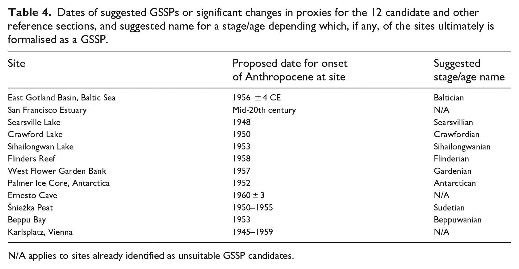
N/A applies to sites already identified as unsuitable GSSP candidates.
Correlation of significant shifts in or appearances of markers between sites documented in this thematic set. Colour of cores reflects environment of formation, as shown in Figure 1.
Most site teams identified plutonium as the primary guide and proposed the base of the Anthropocene relative to a prominent change in its signal. In the Searsville Lake core the proposed GSSP is located just above the lowest occurrence of 239+240Pu in late 1946–early 1947 at a lithological boundary coincident with a lamina deposited in 1948 CE (Stegner et al., 2023), though an alternative level is the marked increase in activity commencing ~1955–1956 CE or first minor peak at 1958–1959 CE. In the Antarctic Peninsula core, 1952 CE is proposed for the onset of the Anthropocene from the initial peak in 239+240Pu (Thomas et al., 2023). For the Śnieżka peat, 1952 CE is chosen based on a prominent increase in 239+240Pu activity (Fiałkiewicz-Kozieł et al., 2023), while at Beppu Bay, the initial upturn in Pu values in 1953 CE is chosen. For the East Gotland Basin, changepoint analysis of 239+240Pu and 241Am indicates a prominent upturn at 26.5 cm depth (1956 ± 4 CE), coinciding with a prominent colour change (Kaiser et al., 2023). Further change point analyses of anthropogenic pollutants (SCPs, MPs, metals, DDT, PAHs, coprostanol) and organic proxies (TOC, TN, δ15N, δ13C, brassicasterol, tetrahymanol) indicate that for these proxies the most significant change occurs at 25.5 cm (1960 ± 4 CE). In the Sihailongwan Lake core, statistical analysis of all measured proxies identified a 1954 change point, but the rapid increase in 239+240Pu activities at 88 mm (1953 CE) was selected as the preferred GSSP level (Han et al., 2023), supported by rapid increase in radioactive 129I concentrations from ~1950; alternatively, the base of the lowermost dark-yellow lamina at 85 mm (1955–1956) forms a prominent lithological boundary. For the Crawford Lake core, the GSSP is proposed at 15.6 cm depth, at the base of the calcite lamina deposited in the summer of 1950 CE, selected because of the rapid rise in key markers between 1950 and 1954 and in particular the primary guide of 239+240Pu having a significant initial upturn at ~1950 CE (McCarthy et al., 2023). A prominent triplet of laminae mark the summers of 1956, 1957 and 1958 CE, with the proposed GSSP located near the base of a ~1-cm-thick interval below in which there are weakly perceptible white laminae. The GSSP level selected for the Flinders Reef core at 1958 CE is primarily based upon an upturn in 14C activity, broadly coincident with secondary markers of δ15N and δ18O, which respectively show increase in 1955 and 1958 (Zinke et al., 2023). The 239+240Pu signal is also quoted as a primary marker coincident with peak values, but the profile has multiple peaks (1948, 1954, 1960 and 1966 CE) suggesting sources from the Pacific Proving Grounds, atypical of global Pu signals which have a lesser peak in 1959 and main peak 1963 CE. The West Flower Garden Banks site differs from Flinders Reef in having clear upturns in 14C from 1957 CE and 239+240Pu from 1956 CE. The Ernesto speleothem, San Francisco Estuary and Karlsplatz Museum sites were proposed as suitable reference sites, no GSSP level being proposed for them.
The East Gotland Basin site shows a visually clear lithological change in 1956 ± 4 CE that closely coincides with many of the analysed anthropogenic pollutants and organic proxies. The Beppu Bay site shows that the timings of the significant changes of the diverse markers are diachronous and progressive, but the numbers of the signatures abruptly increase after 1953 CE, a level coincident with a visible flood event layer (Table 3). The San Francisco Estuary core also displays late signals in the 1960s (Hg and SCPs) and 1980s (137Cs, Pu, total C and N and invasive species). This core has a poorer chronological constraint, no clear GSSP level and with insufficient thickness of underlying Holocene deposits, precluding it as candidate GSSP (Table 2), though valuable as a reference section.
The Crawford Lake and Sihailongwan Lake sites show close similarities despite their geographical separation, the latter being condensed but sufficiently resolved to separate successive events and to recognise annual signals. Both show clear, pronounced changes through the mid-20th century from a range of regional to global signals. The Searsville Lake site is radically different in nature, with high accumulation rates providing thicker layers of marker signals and limiting the functionality of some chronological techniques.
The two coral sites have extremely well resolved chronologies. Interestingly, the Flinders Reef has a 3-year lag in the onset of the radiocarbon bomb-spike (consistent with a Southern Hemisphere to Northern Hemisphere lag), and a 5–10 years lag in the peak compared with the West Flower Garden Bank in which the record is consistent with those from other Gulf of Mexico corals. Consequently, the Flinders Reef shows a key date of significant change in 1958, one year after the key date 1957 from the West Flower Garden Bank, which is likely due to differences in atmospheric circulation between hemispheres. The West Flower Garden Bank has a 239+240Pu profile generally reflecting globally sourced fallout, whereas the spiky profile at the Flinders Reef suggests that the Pacific Proving Grounds have sourced regional signals.
The Palmer ice core represents one of the most pristine environments on Earth, and here tested the extent to which any anthropogenic record was clearly preserved. Though at low concentrations, a Pu bomb-spike is evident, and SCPs are recorded for the first time in Antarctic ice. Changes to methane concentrations in the atmosphere, uniquely preserved in this environment within ice bubbles, show several marked inflexions including in ~1954 CE. The Śnieżka peatland, in contrast, is close to industrial contamination sources in Central Europe, but includes many markers that are consistent with a 1950s base for an Anthropocene series.
Ernesto Cave, despite being the thinnest section analysed by at least an order of magnitude (Table 1), nonetheless allows recognition of proxies consistent with the Anthropocene. However, the inherent lags affecting this speleothem record, while of negligible relevance in defining the Meghalayan Stage (in speleothem KM-A; Walker et al., 2018, 2019), reduce their suitability in an Anthropocene context. Recently analysed annually laminated stalagmites from the Cook Islands, Oceania, where a barren, soil-free karst results in little or no lag (Faraji et al., 2023), show that such speleothem sites may more directly track Anthropocene signals.
The anthropogenic deposits of Vienna are acknowledged by Wagreich et al. (2023) to be unsuitable as a GSSP candidate, but have great value as a reference site allowing correlation into urban deposits. The succession includes gaps in deposition, has significant facies changes across these omission surfaces, has only been dated via artefacts and the section is no longer accessible for research.
The AWG during late 2022 began using these detailed site assessments to determine which one should be proposed as the candidate GSSP, and to suggest additional auxiliary sites. Should this site be approved and ratified, its name will guide the name of the stage defined by the GSSP (Table 4). If the AWG, SQS, ICS and IUGS EC accept that the Anthropocene warrants series/epoch status, its base will be coincident with that of this newly named stage.
Footnotes
Acknowledgements
This thematic set and corresponding analysis of the 12 sites were facilitated by a collaborative research project between numerous research laboratories (acknowledged in each respective publication) and the Anthropocene Working Group (AWG) to define the stratigraphic Anthropocene (see Afterword by Rosol et al., in this issue). We gratefully acknowledge the Haus der Kulturen der Welt (HKW, Berlin) for its support and collaboration. The collaboration was realised in the framework of HKW’s long-term initiative Anthropocene Curriculum, an international project for experimental forms of Anthropocene research and education developed by HKW and the Max Planck Institute for the History of Science (MPIWG, Berlin) since 2013. The contributions of the 12 project leaders and the comments of an anonymous reviewer to improve the content are gratefully acknowledged.
Declaration of conflicting interests
The author(s) declared no potential conflicts of interest with respect to the research, authorship, and/or publication of this article.
Funding
The author(s) disclosed receipt of the following financial support for the research, authorship, and/or publication of this article: This work was supported by the Haus der Kulturen der Welt, Berlin.