
Abstract
Countries may utilize a long coastline in relation to their landmass as a resource to develop their maritime economy. This paper argues that ASEAN countries differ in utilizing their maritime potential. As a basis for further comparative studies the Center for Policy Research and International Studies (CenPRIS) in Penang developed a set of indicators to measure the maritime potential of nations, the state of their maritime industries, and the degree to which the maritime potential has actually been utilized. Using the CenPRIS Ocean Index (COI) shows that Brunei and the Philippines have underutilized their maritime potentials, whereas Singapore and Thailand have made full use of it. Malaysia still has the potential to further develop its maritime economy.
Maritime Resources
In a global world economy countries have to strive to improve their competitive position versus each other by using their available resources. All nations and regions are endowed with resources that range from minerals, oil and arable land to cultural diversity and knowledge assets. These assets are unevenly distributed between countries that have made full or less than optimal use of these resources. Fortunately there is a trade-off: Nations without natural resources can compensate for this by using human resources, talents and knowledge to maintain and enhance economic and socio-political performance. Nevertheless the search for new resources is still on, and once resources are defined they can be classified as either optimally utilized, over- or underexploited. Another aspect would be sustainability. A short-term economically “optimal” exploitation of a resource may lead to its extinction in the long-run. Over-exploitation of fisheries would be an often discussed example. Sustainable development rather than just optimization of resource exploitation needs to be emphasized. A new perspective would, however, be the search for resources that are not threatened by extinction through economically optimal exploitation. The search for renewable resources, like solar, wind or biologically renewable energies been one avenue, another less often discussed resource is location. This research note will emphasize location with access to oceans and sea lanes as a sustainable resource, which may be turned into a competitive advantage of a region or nation.
Measuring the Maritime Potential
Numerous ranking systems have been designed to show the relative position of countries either regionally or globally. The underlying values and indicators are diverse but combined into indices they show whether a country holds a top position on dimensions like economic growth, good governance, human development, corruption, technology readiness or knowledge assets. 1 These indicators are usually devised to monitor socio-economic trends, but are also used as planning instruments that provoke administrative action or monitor results of policy measures. The CenPRIS Ocean Index (COI) described in the following paragraphs is a combination of the Maritime Potential Index (MPI) and the Maritime Economy Index (MEI). It is designed to measure how much a nation has utilized its geographical location next to seas and oceans to develop a maritime economy. 2
For example, UNDP: Human Development Index (HDI), Worldbank: Knowledge Economy Index (KEI), World Economic Forum: Technology Index, and many others.
The indices were developed jointly by a team from the Centre for Policy Research and International Studies (CenPRIS), Universiti Sains Malaysia and the Center for Development Studies (ZEF), University of Bonn.
The Maritime Potential Index (MPI) measures the geographical dimension of the natural resource “proximity to seas and oceans”. It shows the natural potential of a nation, state or region to make use of this resource. A landlocked state has no natural potential to use maritime resources, whereas the potential of an island state or a state with a long coast line should be very high. The Maritime Economy Index (MEI) combines various typically maritime industries like fisheries, shipping, ship building, harbours and other economic fields. Whether or not the potential is utilized is measured by the CenPRIS Ocean Index (COI).
A less often discussed natural endowment consists of coasts and access to the world oceans. Nations with a long coastline will be in a better position to make use of maritime resources than countries with a short coast line, let alone land-locked countries. A long coast line offers the opportunity to engage in fishing, ship building, sea transport and other maritime industries. Its harbours facilitate international shipping, labour migration and the transfer of goods and knowledge. Location along an ocean and access to blue water, maritime ecology and marine bio-diversity are as much a natural resource as gold, copper or oil, but unlike other natural resources it is fairly stable, not easily depleted and therefore naturally sustainable.
A look back in history shows that several great civilizations have been built on the advantages of a long coastline. The Roman Empire on Italy's far-stretched peninsula as well as Great Britain with its island position are civilizations that have made extensive use of their long coastlines and access to seas and oceans. The same holds true for Sumatran-based Srivijaya, and classical Melaka on the Malay Peninsula.
Measuring the Maritime Potential of ASEAN
Countries with a long coastline in relation to their landmass have a competitive advantage over countries with a shorter coastline. The Maritime Potential Index (MPI) is a composite measure of the geographical maritime potential and therefore a selected aspect of the competitive advantage of a nation.
The question is, then, whether ASEAN nations have made use of this potential and turned it into a competitive advantage in relation to other countries in their reference group. Our data for 2005 shows that ASEAN countries have, indeed, made different use of their maritime potentials. Brunei, Cambodia, Myanmar, Thailand, and Vietnam rank below the average Ocean Index, Indonesia, Malaysia, the Philippines, and Singapore rank above the average.
Comparing the ASEAN countries, Singapore due to its big container harbour ranks highest, Brunei, Cambodia, Myanmar and the Philippines below the average of the Maritime Economy Index (MEI) (see figure 2). If we take, however, the maritime potential into account, a quite different picture emerges (figure 3). Singapore and Malaysia, the achievement index (CenPRIS Ocean Index, COI) says, have achieved less than would have been expected according to the Maritime Potential Index (MPI). Both countries rank on the CenPRIS Ocean Index (COI) only minimally above the ASEAN average.
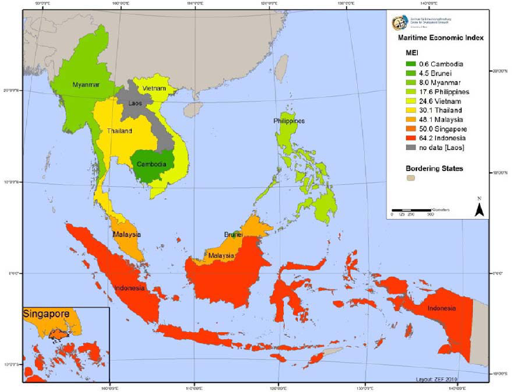
Maritime Economy Index, ASEAN 2005
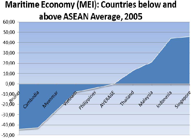
Maritime Economy: Countries below and above ASEAN MEI Average, 2005
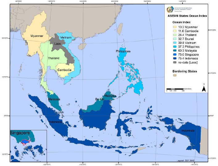
CenPRIS Ocean Index (COI), ASEAN 2005
As for all other indices, comparing time series tends to reveal the most relevant results. Comparing the development of the Ocean Index from 2000 to 2005, it is evident that the utilization of the maritime potential has increased by about 11%. Malaysia's COI has risen by 57%, the highest next to Singapore. Likewise, higher values are also calculated for Indonesia and Vietnam. But changes of the CenPRIS Ocean Index of Brunei, Myanmar, and Cambodia seem to be negligible (table 1). These countries have remained below the average for all ASEAN nations (excluding, of course, landlocked Laos).
CenPRIS Ocean Indices, ASEAN 2000 and 2005
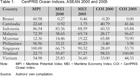
Note: MPI = Maritime Potential Index; MEI = Maritime Economy Index; COI = CenPRIS Ocean Index.
Source: Authors’ own compilation.
This research note should be read as a first step towards the development of a more comprehensive and robust ocean index (COI). Towards this end additional variables will have to be introduced to enhance the accuracy of the Maritime Potential Index (MPI) and the Maritime Economic Index (MEI).
A Note on Methodology
In constructing the indicators we have largely followed OECD standards (Nardo, Saisana et al. 2005). We have also adopted standard computing practices used for the Human Development Index (UNDP 2009: 208-212) and the Knowledge Assessment Methodology (KAM) of the World Bank (World Bank Institute 2008). The GIS mapping methods are described in our earlier paper (Evers, Genschick, and Nienkemper. 2010).
For the Maritime Potential Index (MPI), the standardized variables “Mean Distance to coastline in kilometres” (MDC) 3 and “Percent of coastline of total country outline” (PCTCO) were chosen. The last mentioned variable potentially ranges between the poles of a landlocked country (= 0) and a pure island country (= 100). The variable “Mean Distance …” generally relativises the maritime potential for those countries, which may have a higher percentage of coastlines in their total outlines but on the other hand also have relatively big landmasses; those countries are assumed to have a relatively lower maritime potential, which should be reflected in the MPI.
The values for this variable were substracted from the value 100 so that both variables “Mean Distance to coastline (in kilometres)” and “Percent of coastline of total country outline” have the same poles (100 = high maritime potential; 0 = low maritime potential).