
Abstract
Informed by critical cultural justice inquiry, this article reflects on participatory mapping activities undertaken on Norfolk Island that were aimed at capturing practices, routes, and emotions associated with Kingston and Arthur’s Vale Historic Area. We discuss how participants understood the parameters of mapping tasks; adapted and individualized activities; engaged in collaborative practice; and exercised reflexivity. The article finds that participatory mapping captures variances in how participants relate to and engage with Kingston. The article emphasizes the importance of recording conversations during participatory mapping to offer greater nuance and insight into visual data recorded on the maps.
Keywords
Introduction
Participatory mapping has the capacity to illuminate places, relations, memories, and practices that may be excluded or obscured by traditional maps. This article reflects on participatory mapping activities undertaken for the Australian Research Council-funded project, “Reimagining Norfolk Island’s Kingston and Arthur’s Vale Historic Area” (2021–2024). Norfolk Island is a small, remote island located approximately 1,470 km southeast of Brisbane, Australia, with a population of 2,200 (Australian Bureau of Statistics, 2022). There are four key human settlement periods in the island’s history: a Polynesian settlement (c. 1150–1450); a British agricultural settlement (1788–1814); a British penal settlement (1825–1855); and the Pitcairn settlement (1856–present). Norfolk Island is home to the UNESCO World Heritage-listed Kingston and Arthur’s Vale Historic Area (also known as KAVHA, Kingston or, in the Norf’k language, Daun’taun). Although its heritage listing and past heritage management plans place emphasis on KAVHA’s colonial heritage, Kingston is also a rich living heritage site. The island’s Pitcairn settler descendants—who make up a quarter of the island’s population (Australian Bureau of Statistics, 2022)—are an ethnically, culturally, and linguistically distinct group of people descended from Polynesian women and British men who, following the HMS Bounty mutiny in 1789, began a community on Pitcairn Island; the entire population of Pitcairn relocated to Norfolk Island in 1856 with the intention of being its sole occupants. A long history of tensions ensued between the Pitcairn settlers on Norfolk Island and the British colony of New South Wales (see, e.g., R. Nobbs, 2006) and, from 1914 onwards, the Commonwealth of Australia (see, e.g., O’Collins, 2010), including more recent impacts of the removal of self-governance (see, e.g., C. Nobbs, 2017, 2019, 2021, 2023). In the context of Kingston, this history has been marked by the experience of numerous injustices, including the evictions of Pitcairn settlers from their homes in 1908 and the removal of islanders from key decision-making roles attached to KAVHA’s management in 2016. Opposition to the current governance model of the island is visible in the ongoing presence since 2016 of a Tent Embassy on the grounds of Kingston’s Old Military Barracks.
Our project aims to reimagine Kingston through amplifying, in particular, Pitcairner settler descendant memories, experiences, and knowledge, as well as stories of other island residents who have long and deep connections to the site. In contrast to the top-down consultation, interpretation, and management processes that have dominated Kingston in recent years, our project has sought to work with the community from the ground up, using collaborative and arts-based methods to co-produce outputs that tell Norfolk Islanders’ stories and share their views on their own terms. The research can be described as participatory while acknowledging that participatory research ranges “from being minimally participatory to being fully egalitarian” (Brown, 2022, p. 201). The Reimagining KAVHA project is situated between these two extremes, with the level of participation varying across different research activities. Though arts-based research is often imagined as intrinsically participatory, Brown (2022) cautions that using creative methods in research “does not automatically translate into a participatory research design” (p. 201). According to Brown (2022), “participatory research enables participants to be involved in, take charge of and [be] responsible for the research process” (p. 207). While this does not mean individuals need to participate in every aspect of research design and delivery, “it does mean that the researcher needs to position themselves reflexively, transparently and critically” at every turn (Brown, 2022, p. 207).
Our approach to participatory research is informed by critical cultural justice inquiry—a conceptual, methodological, and practical approach to attend to cultural injustices in research and practice. Conceptually, cultural justice encompasses doing justice to and through culture—valuing cultural infrastructure, rights, identities, materialities, institutions and work, and attending to matters of power, representation, participation and access (Baker et al., 2023; Cantillon et al., 2021). Critical cultural justice inquiry, then, is concerned with the cultural expressions and dimensions of justice while also contributing to critical understandings of the symbolic and material consequences of cultural practices, processes, products, and policies. Methodologically, critical cultural justice inquiry emphasizes multiplicity, reflexivity, and collaboration in research, including through the use of participatory methods, such as participatory mapping, which can serve to highlight cultural injustices. Practically, critical cultural justice inquiry is concerned with producing resources and guidance that can equip participants and end-users of research with “tools and processes to reflect on, discuss and resist” cultural injustices (Baker & Cantillon, 2022, p. 545). What this form of inquiry shares with other frameworks and approaches described as participatory is its emphasis on doing research with participants rather than on subjects (Vaughn & Jacquez, 2020).
This article reflects on participatory mapping workshops we undertook with Norfolk Islanders to capture practices, routes, and emotions associated with Kingston that are often intangible, ephemeral, or undocumented in authorized heritage management and interpretation practices. We focus primarily on methodological insights about mapping, with less attention given to thematic findings about place (which can be explored further in Baker et al., 2023) or the conceptual and practical aspects of critical cultural justice inquiry, except where these are instructive about the methods used. Below, we summarize some relevant literature on maps and participatory mapping, especially in relation to the heritage field, before outlining our chosen methods and methodological approach. We then discuss experiences of the mapping workshops in terms of four key areas: how participants understood the parameters of each task; adapted and individualized activities to express what they felt was important; engaged in collective, collaborative practice; and exercised reflexivity along with the researchers. The article finds that participatory mapping can overcome the limitations of traditional cartographic practices by capturing variances in how participants understand, relate to, and engage with Kingston. However, the recording of conversations during participatory mapping activities is critical if researchers are to more fully tease out the visual and aesthetic information recorded on participatory maps. In this sense, the value of participatory mapping is less about the maps that are produced and more about what is revealed during the process of mapping.
From Traditional to Critical Cartographies: Participatory Mapping for Critical Heritage Studies
On Norfolk Island, hegemonic cartographic practices and products dominate the historic record with ramifications for the understanding of the living heritage of Pitcairn settler descendants. For example, the historical maps and contemporary mapping practices that have been central to heritage management in Kingston since 1980 are “part of a system that prioritises ‘expert’ knowledge and ways of working (e.g., cataloguing, segmenting, assigning value)” (Baker et al., 2023, p. 537). As we have previously illustrated, the cartographies that underpin heritage management in KAVHA can reinforce injustices and “flatten what are in reality, complex relationships that local residents have with different spaces” in the World Heritage-listed site (Baker et al., 2023, p. 549).
Maps, like all representations, “are not neutral reflections of the world,” but are “socially and politically constructed texts” (Baker et al., 2023, p. 534; see also Harley, 1988). Processes of mapping, surveying, “discovering,” and otherwise carving up and naming space have been core to coloniality and other processes of power (see, e.g., Sletto, 2009). Traditional maps are also simplifications or abstractions of often complex, pluralistic experiences and relations (Wainwright & Bryan, 2009). They are primarily visual forms that foreground tangible dimensions of the landscape, such as topography, buildings, roads, rivers, and water bodies. As Reitz (2022) observes, “traditional maps fail to recognize the importance of subjective spatial experiences . . . that foster connection and place attachment” because “[a]bstract qualities of space challenge representation: the passing of time, flows and rhythms, memories, values, and interests” (p. 328).
To critique and counteract some of these issues with traditional maps, a range of techniques have been developed such as participatory mapping/cartography (e.g., Rye & Kurniawan, 2017; Sletto, 2009), counter-mapping (e.g., Boatca, 2021; Peluso, 1995), sketch mapping (Boschmann & Cubbon, 2014; Lobo et al., 2020), hand-drawn mapping (e.g., Nolte-Yupari, 2020), social cartography, and deep mapping (e.g., Reitz, 2022). Such participatory mapping practices can capture both expected “stock” stories and less obvious “concealed” stories (Bell, 2010; Nolte-Yupari, 2020). Relating to the latter, participatory maps seek to elevate and do justice to marginalized, “unseen,” or “unheard perspectives” (Reitz, 2022, p. 327, 328), revealing experiences and relations that may be “veiled” in traditional maps (Campos-Delgado, 2018). These techniques highlight how maps can be used as a tool for resistance, disrupting dominant perceptions of space and place and documenting or amplifying other ways of seeing and relating to the world. Kim (2015) has posited that participatory techniques can be categorized as either “testimony mapping,” whereby maps are used to re-present subject matter (whether that be injustices or other forms of “overlooked phenomena”), or “visionary mapping,” which is more focused on reimagining “to present alternatives of what could be” (p. 215).
In critical heritage studies and related fields, the use of participatory mapping is connected to the growing recognition of the importance of local communities’ experiences, interests, values, and knowledge in relation to their own heritage—rather than only that of heritage professionals or “experts” (see Schofield, 2016; Smith, 2006). In Hussain’s (2021) study, for instance, local communities were invited to “‘draw-in’ tangible, immaterial, invisible, human, spiritual, and more-than-human entities, and their worlds that are at risk of erasure”—qualities of space that may not always be featured in traditional maps or conventional heritage interpretation practices (p. 217). Álvarez Larrain and McCall (2018) report that the benefits of participatory mapping in the field of archeology can include strengthening relationships between archeologists and local communities; “incorporating indigenous/vernacular knowledge” to identify new heritage sites and enhance the interpretation of current sites; and creating “more socially useful archaeology” (p. 664). Moreover, De Nardi (2014) notes that participatory mapping can assist in showcasing that heritage sites are not just the locations of artifacts or fossils, but “lived-in cultural landscape[s]” (p. 6). Álvarez Larrain and McCall (2019) do note, of course, that there can be several drawbacks to participatory mapping, such as issues with the oversimplification of rich, complex local and/or lndigenous knowledge; unequal power relations between researchers or heritage professionals and local communities; and the potential that the maps created might “fix or solidify a sense of space and place that, in reality, is much more dynamic, fuzzy, ambiguous, imprecise, and often emotional and spiritual” (pp. 665–666). To mitigate such issues, it is crucial for mapping methods to be “adaptable” (Álvarez Larrain & McCall, 2019, p. 666) and “promot[e] transparency, time sensitivity, flexibility, and trust” (p. 669).
Map-Making Methodology
Methodologically, participatory mapping should be designed to foster “dialogue, empowerment, and transformation” (Reitz, 2022, p. 328). Writing about social cartography, Reitz (2022) argues that there is “an intrinsic social justice orientation in this method” in that “[s]ocial maps give concreteness and a sense of urgency to issues perceived and criticized by the most vulnerable,” making them “compelling tool[s] for protest” (p. 351). This capacity is enhanced by “the active involvement of communities in the process of mapping” (Reitz, 2022, p. 351). Kim (2015), however, critiques the idea that new critical cartography methods are inherently participatory and democratizing. They suggest that researchers should acknowledge and be reflexive about “the critical cartographer’s own position and influence of the project,” “choices made of what not to include in the map,” “the politics of aesthetics,” and how to pursue “deeper social engagement” regarding what the map does and what it was made for (Kim, 2015, p. 215). On the latter point, Kim (2015) explains that: The social position of the new map and how it engages institutions is key. In other words, it is not enough to just put a map “out there.” While visualizing new knowledge claims is a valuable feat, if a critical cartography map does not engage, its radical claims may be a farce (pp. 216–17).
Below, we have endeavored to address Kim’s suggestions in our own mapping process and explicitly return to them in the article’s conclusion. We note that a part of the critical cultural justice approach to participatory mapping involves making the means of production of maps more transparent, and in this article, we seek to provide a clear account of the opportunities and challenges we face.
The Reimagining KAVHA research team is composed of two residents of Norfolk Island (Sarah and Chelsea) and one resident of the Gold Coast, Australia (Zel). Chelsea is a Pitcairn settler descendant, and Zel and Sarah are of European (Zel) and British (Sarah) descent. The project uses qualitative methods for data collection, primarily semi-structured interviews and multi-method zine-making workshops. This article reports specifically on findings from three 3-hour workshops undertaken in September 2022, which were focused on participatory mapping of KAVHA. Participants were invited to map “sites of significance, practices, feelings and movements ‘from below’ as an alternative to the official types of maps, tours and signage that originate ‘from above,’ designed and distributed by groups such as heritage management authorities” (Baker et al., 2023, p. 537; see also Muzaini & Minca, 2018). The workshops were held at the Centre for Democracy, an indoor space located on the main street of Burnt Pine and operated by the Norfolk Island People for Democracy (see Figure 1). The workshops operated on a “drop-in” basis, with attendees contributing as little or as much as they desired. Of the project’s 69 total participants, 27 attended the mapping workshops, with 11 of those having previously contributed to other data collection activities for the research.
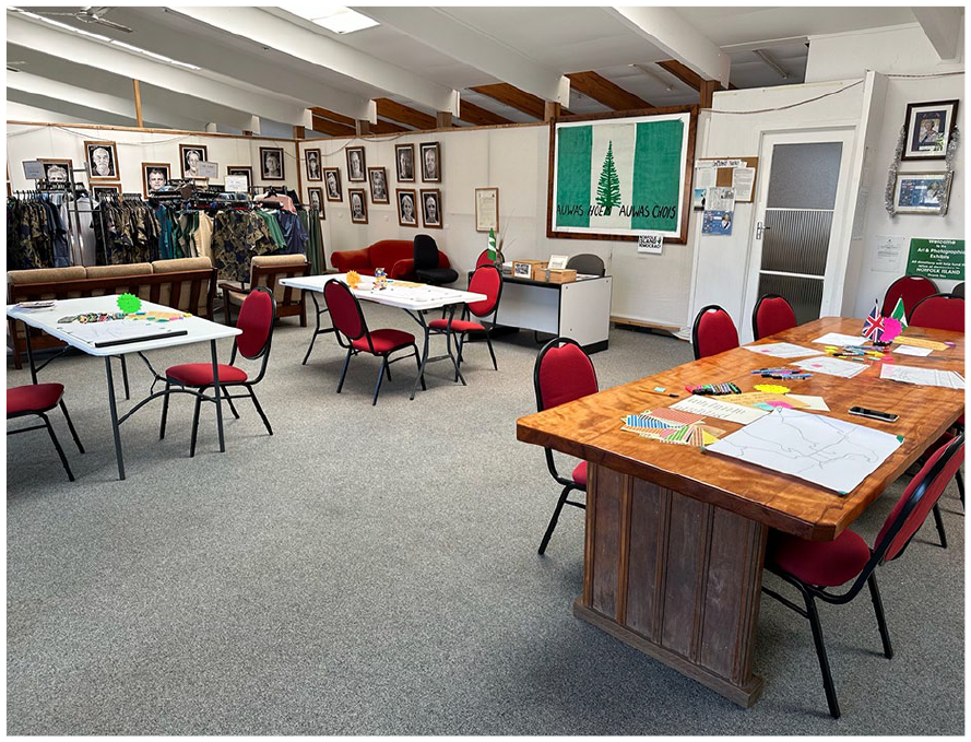
Tables With Mapping Activities at the Norfolk Island People for Democracy Space.
Each workshop was organized around four activities using printed copies of a base map (see Figure 2). To create the base map, Zel traced a screenshot of the Google Maps birds-eye view of the official boundaries of the Kingston heritage-listed area using ProCreate on iPad. The research team decided to keep the base map as simple as possible, only including the coastline and a few of the main roads to help orient people. We chose not to include any street names, labels, or landmarks, so as to not make assumptions about what was considered significant enough to be included—that was the task for participants.
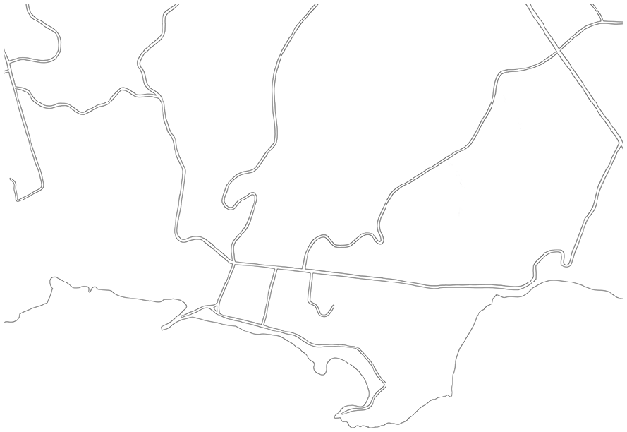
Base Map Depicting the Coastline and Main Roads Within Kingston and Arthur’s Vale Historic Area.
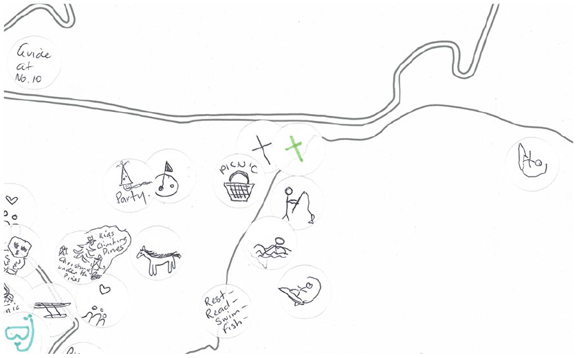
Three activities invited attendees to contribute to large (A2-sized), collaboratively produced maps, while the final activity invited them to work on their own smaller (A4- or A5-sized) individual maps. The prompt for the first activity was: “How do you move through Daun’taun? Draw your routes (driving, walking, biking, etc.).” These could be past or present, or a combination. Our intention was to highlight how people move through space and how this changes over time. It was also intended as an ice-breaker activity that would provide the participant with an opportunity to become familiar with the base map and to reflect on their connection to Kingston at a more rudimentary level before moving on to activities that demanded more challenging forms of reflection. The second activity asked: “Where do traditional or customary practices take place?” We asked people to draw symbols that represented these practices onto stickers and attach those to the particular spots where the practice occurs. This prompt was inspired by one of the project’s interviewees who felt that capturing Norfolk Islanders’ customary practices could be integral to their claims for having a distinctive culture that is in need of protection and respect. The third activity was designed to create a “heat map” that represented the most emotionally charged sites; it posed the questions: “How does Daun’taun make you feel? What emotions are attached to specific locations?” This prompt built on findings from the interviews and zine-making workshops, which detailed “a plurality of attachments” (Tolia-Kelly et al., 2016, p. 5), including the role of affect and emotion in how Norfolk Islanders engage with Kingston as a site of “living heritage” (Poulios, 2014). Drawing attention to emotions is important because, first, it is broadly recognized that heritage sites are imbued with feeling; second, “emotion is a form of evaluative judgement of matters that are understood as affecting . . . well-being” (Smith & Campbell, 2015, p. 448); and third, emotions are “historically and culturally contingent, and bound up in power relations and politics” (Wetherall et al., 2018, p. 2). Participants were provided with a predefined list of emotions and corresponding colored stickers that reflected emotive words that had frequently popped up in our engagements with contributors to the project, but they could also add their own. The fourth and final activity invited participants to create an individual map: “Add the locations, spaces and places that are most important to you (e.g., family, personal, community).” This activity was intended to give contributors an opportunity to mark down anything that was missed in the collective activities.
To extend the visual representations of participant experiences on the maps, we recorded all of the conversations that accompanied each mapping activity, with the research team asking probing questions to “facilitate a process of: description—elaboration—theorisation” (Emmel, 2008, p. 2). To capture the multitude of conversations happening simultaneously, in each workshop there were multiple recording devices. Devices placed at the four activity stations in addition to roaming digital recorders produced a total of 31 hours of audio. The recordings were time-stamped and partially transcribed by Chelsea to capture participants’ observations about their decisions on what to include on the maps, challenges experienced in articulating their relationship to Daun’taun, and reflections on the mapping activities. The timestamping document was then coded by the authors, noting specific themes that emerged from the mapping tasks relating to the process of participatory mapping. Written components of the maps were transcribed and coded thematically, while visual representations such as stickers and drawings were categorized according to their location on the map.
The maps we created were published in 2023 across three zines—one each focused on the collaborative activities, with individual maps interspersed throughout—as part of the Reimagining KAVHA zine series and can be accessed on the project website (https://reimaginingkavha.com/). Zines are self-published booklets, often with a do-it-yourself, cut-and-paste or bricolage aesthetic. They have a history as tools for activism; much like participatory maps or counter-maps, zines subvert dominant modes of cultural production and represent marginalized perspectives (Baker & Cantillon, 2022). In our project, we conceptualize zines as a community archive that “work[s] to strengthen the presence of marginalised voices in dominant historical narratives while also offering an important resource for community-building and political resistance” (Baker & Cantillon, 2022, p. 543). The project zines purposefully attend to community archiving principles of affect (see Caswell, 2020), reflexivity, archival activism, multiplicity, shared stewardship, participation (Caswell, 2014), and collaborative reminiscence (Baker & Cantillon, 2022). The zines incorporated both researcher-led and participant-generated content, including pages where contributors were fully responsible for writing copy, image selection, content curation, and page display. The zines were lodged in libraries and archives on Norfolk Island, distributed to project participants, and made freely available to other interested locals for circulation in the community. In addition to their publication in the zines, the nine collaborative maps were also made available for download on the project website.
The Participatory Mapping Experience
Understanding Activities
As participants sat down to complete each activity, they would often take a few moments to orient themselves to the task of mapping. Many needed time to adjust to the base map, expressing confusion about where particular sites were located: “What is this road? This is confusing me,” “Oh, I’m lost” (Sharyn) 1 ; “I’ve got to get my bearings right here” (Eddy); “Where am I?” (Pat); “Where’s the Assembly?” (George); “Where is Queen Elizabeth Lookout?” (Deb); “I’m so confused . . . I need some guidelines, some words” (Margaret); “Weyas auwa?” 2 (David). In some cases, this led to contributors placing stickers and markings in the incorrect spots on the maps. On the Emotions map, for example, stickers indicating hurt, anger, and sadness that appear in the location of the Pound Paddock were actually intended for the New Military Barracks but were misplaced due to Albert and Chelsea being momentarily disoriented. Mikiela explained this experience of disorientation with the base map, commenting that “when focusing on Kingston, I would think of it as a whole rather than in a bird’s eye view.”
Participants also sought to clarify the parameters of each activity before making a start on adding their contributions to the maps. Though participants were assured there was no wrong way to undertake the tasks, they double-checked what might be expected of them: “So I just run around, do I?” (Michael); “Wi el jes yuus eni kala fe work?” 3 (Gaye); “So what you are saying is that we put the sticker down, is that it?,” “How far back are we going with emotions?” (Fran); “You can write on this?” (Ken). On the collective maps, most participants were contributing to maps that were already populated by markings, stickers, and words from earlier attendees, leading some to check in with the research team about what they were looking at: “So what we see here is all from today?” (Deb). There was also a question around what constitutes a “customary practice,” with participants trying to discern if an activity they undertake in KAVHA, whether it be diving off the reef or collecting eels from the creek, would be considered “a traditional or customary practice” (Kym). In such cases, they were reassured that there are “a lot of different ways to interpret what a customary practice is” and that the map can capture “things that are important about the space” (Zel) and its uses.
Individualizing Activities
Although the mapping activities were predefined by the research team, workshop attendees had the opportunity to exercise agency and make the task their own. Each activity was designed to be individualized to an extent—participants were encouraged to use different colors and patterns in the Routes activity, add new feelings to the Emotions key, and think up their own ideas about what counts as a customary practice and how to represent that through a drawn symbol. For example, on the Routes map, Gaye chose to depict her drive through Kingston using arrows, whereas Chris focused on the use of color: “I need a color that’s unique to me—green, go Nepean.” 4 Looking at the Emotions key, Pat noted that “romance” had not been included. For Pat, this was a word that captured her strong attachment to Kingston. Romance was then represented by a sticker featuring a few small red love hearts, and Pat placed this at the location of the former Paradise Hotel “where I met my husband.” Mikaela wanted to represent Norf’k dancing on the Customary Practices map. She drew a flower symbol and placed these stickers on a number of locations where dancing takes place and then, to increase clarity, added the words “Norf’k daans.” 5
Conversations with the participants during the Emotions activity revealed their different thought processes regarding which emotions to select for sites. Zel questioned Damien about his use of a “hostile” sticker on the Compound:
Ah, the first “hostile,” no one’s used it yet. Why did you put that one there?
For the history of it. Penal settlement, the gaol, hanging people. It’s part of history but to me it’s not a nice history . . . I’ve known people who won’t go in the buildings just because of the feeling they get. They can still feel [it].
In this case, the sticker does not represent Damien feeling hostile, but rather that the site is associated with hostility because of the suffering of convicts. Similarly, Sarah asked Sharyn to expand on why they added “hurt” and “proud” stickers to the Old Military Barracks, to which they explained: “Hurt as in—I’m not hurt that the Tent Embassy is there. The Tent Embassy is the reminder, the symbol of being hurt. But [I’m] also proud of them for what they’re doing.”
Other participants tried to think of ways to convey the extent and intensity of certain emotions. Ken opted to add three yellow “worry” stickers to the New Military Barracks as a way to express a deep concern for the state of the island’s governance at that time. David observed that they felt worry about everywhere:
Yu nor gat wan big yelo thing wi el pat krors d’ hoel lot? 6
You could colour it in.
We could get the yellow highlighter and go over everything.
Pretty much.
But are you worried about everywhere?
David: Of course! Absolutely. Very worried.
. . . did [you] want to do a big yellow –
Or rait et. 7
Worried about everywhere.
We’re worried!
Yeah, do. Go.
This exchange prompted David to draw a box around Kingston in gold pen, adding the word “WORRIED” (see Figure 3). The intensity of this emotion was felt deeply by Chelsea, who responded to David’s contribution with “Daa kaina brek mais hart, anieh.” 8 Chelsea’s broken heart indicates a cascading of emotion, with the mapping activity generating a visceral and deeply felt dimension of collaborative reminiscence, a term that “captures the collective and dialogic memory-work” (Baker & Cantillon, 2022, p. 558) fostered in the mapping workshops.
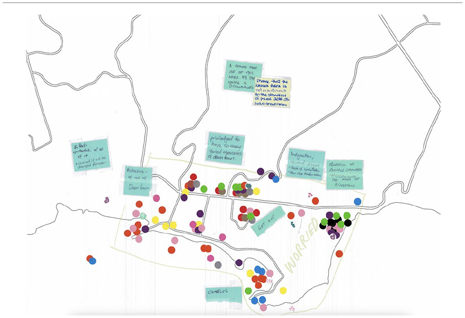
Emotions Map From Workshop 2.
Contributors in workshops 2 and 3 also decided to deviate from the emotion task’s parameters by adding written messages (see Figure 3) rather than only colored stickers. Notes like “get out” and “bugger off” were attached to specific sites, such as Government House, where Australia’s appointed Administrator of the island lives and works. Other times, the written messages were used to express emotions that applied to the whole Kingston area—again, something that was not specifically asked for in the task, which was intended to map feelings associated with specific spots. Such notes included: “indignation, insulted, disgust—lack of consultation—How dem treaten ucklun” 9 and “Fearful of possible changes—modernising the area of Kingston.”
Participants took a similar approach to their individual maps. Rather than only adding points of interest that were personally significant to them, many chose to use written messages (see Figure 4) to make statements about Kingston’s cultural and historical significance to Norfolk Islanders: “Kingston es auwas
10
playground. All relaxation en
11
fun happens in Kingston. Bounty Day, school sports. All serious matters happen in Kingston. Assembly, funeral, government. If Norfolk is our soul then Kingston es auwas heart!” (Gaye) “A place where our way of life and Norf’k culture comes to life each and every day” (Mikiela) “The whole lot is special and so . . . very important to ucklun!!”
12
(Dids) “Its all important. It all has history of my heritage. It’s our peoples first homes. It’s where we love, live, play, rest, eternal” (Tane) “Even with no one there this whole place is constantly occupied by those from the past” (Margaret)
Relatedly, some participants wrote on their maps brief commentary on the political dimensions of the site in relation to heritage management (see Figure 5): “The site Master Plan is . . . taking all of what is ours out” (George) “May they NEVER destroy our heartfelt love of this place by changing or modernising it. It is a NATURAL Beauty—which needs preserving” (Bev)
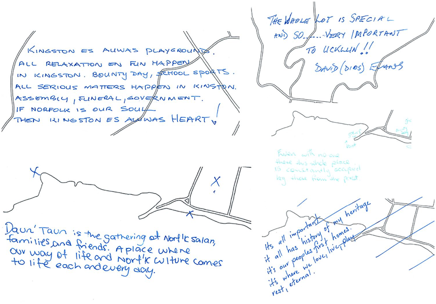
A Selection of Written Messages From Participants’ Individual Maps.
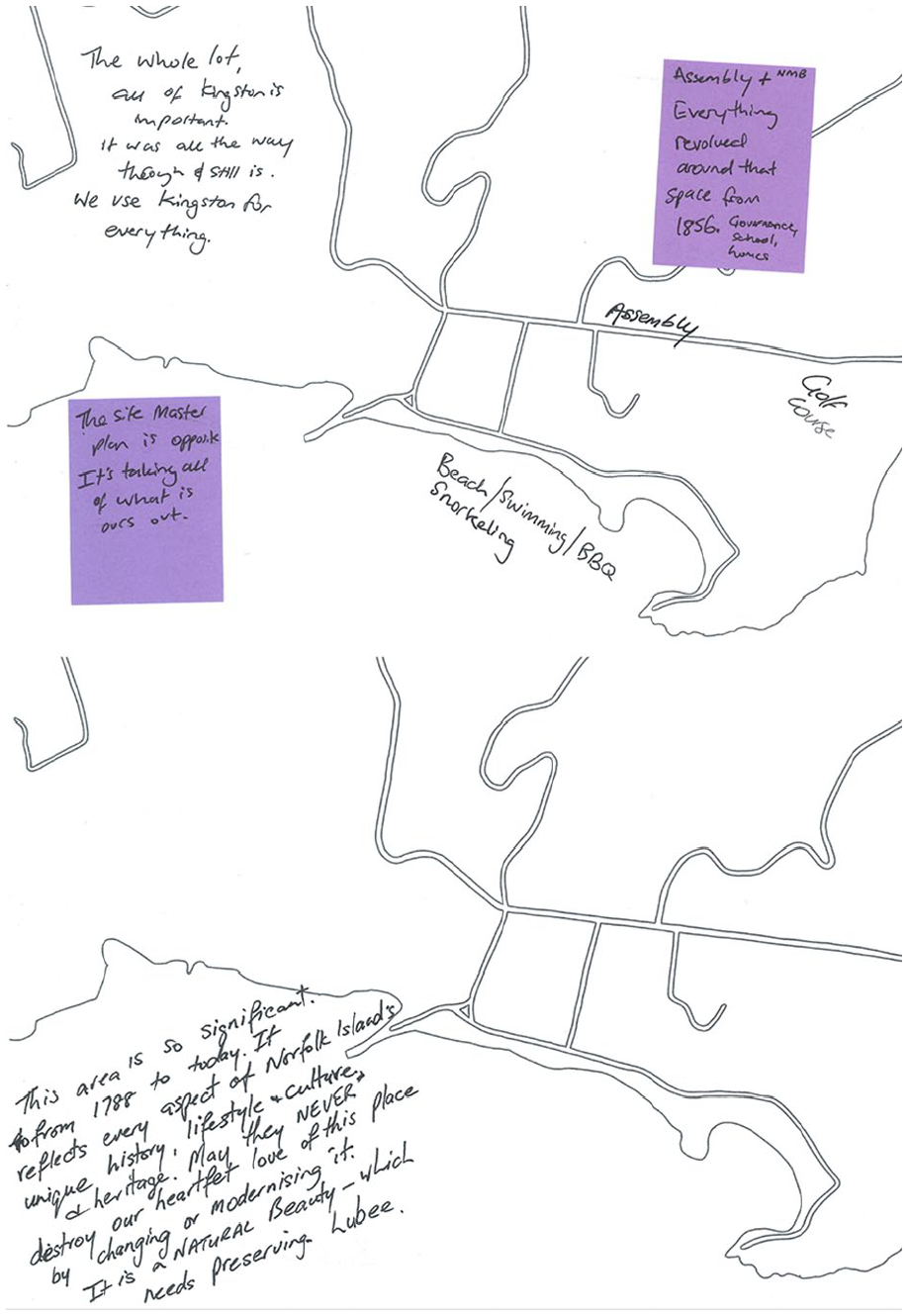
Written Messages From the Individual Maps of George (top) and Bev (bottom).
In these ways, participants individualized and adapted the activities to convey what was most meaningful and important to them and what they wanted to make sure was documented in the mapping process.
Collective Practice
Workshop attendees showed awareness of and engagement with the contributions of those who had added to the maps before them. Sitting down to the Emotions map, Margaret remarked on the Legislative Assembly at the Old Military Barracks: “So, we’re proud and we’re sad and we’re worried. I can understand that mixture.” At other times, participants noticed which emotions were most prominent at particular sites on the map and asked us why people had placed those colors there. For example, Heidi and Amy noticed several “angry” stickers in the Emily Bay/Lone Pine area and asked if this was because of recently installed BBQ areas or the erection of fencing.
Deb commented that seeing others’ symbols on the Customary Practices map served as “good inspiration.” Likewise, participants picked up on new feelings that others had added to the Emotions map key. Gaye queried the addition of “productive,” which had been attached to the Old Military Barracks earlier in the workshop:
Productive was Pat’s contribution. That was because the work that had been done felt productive.
Before or today?
No, not today. The positive feelings of [Pat] working [in the past] as the secretary [to the Legislative Assembly]. So, feeling like important work was being done back in the day . . . Contributing to something worthwhile.
Yes, that’s great. Productive is that funny green? Ok, thank you.
In a subsequent workshop, Michael picked up on Pat’s contribution to the key and added a productivity sticker to a new site: the Kingston Pier, where shipments come in and are offloaded by lighterage workers.
Acknowledging the work others had already put into the maps, particularly the Customary Practices map where participants had drawn bespoke symbols on their stickers, contributors to the workshop would sometimes be hesitant to add further stickers to a particular site for the fear that their additions would obscure what was already there or take away from another’s contribution. Although we told attendees to add whichever customary practice symbols they wished to—stressing that multiple of the same symbol at one site would highlight the popularity of that activity—many were reluctant to “put them over other people’s beautiful work” (Deb). Likewise, on both the Emotions and Customary Practices maps, participants did not always add an additional sticker if one had already been added to a site with the practice or emotion they mentioned, feeling that it was already represented. This was especially the case for sites that looked particularly busy, with contributors asking if there was value in them adding further marks or stickers; working on the Customary Practices map, Margaret expressed: “Obviously, we’re all there [the Cemetery] all the time, aren’t we? So I don’t know how many [people] you need to have . . . putting ticks on the cross?” (see Figure 6).
A Close-Up of Workshop 1’s Customary Practices Map Shows Two Cross Stickers Affixed to the Area of the Cemetery.
A number of attendees came to the workshop with friends or family, and in these instances, each activity was undertaken together with the participants sitting around the same map to add their individual marks and stickers while simultaneously talking through their decision-making process. In these cases, a sticker placed by one member of the group could prompt others to replicate an emotion or activity at a particular site. For example, Fran attended with daughter Kym and they tackled each activity together. Fran spoke extensively about feelings attached to a memorial garden on Rooty Hill Road. Kym asked Fran if nostalgia would be the emotion sticker to add on that part of the map, to which Fran agreed, saying this would also be a feeling of respect. The discussion prompted Kym to ask Fran, “Can you put a nostalgic at the church too please, Mum?,” and Fran then added this sticker on behalf of Kym. These collaborative engagements with the maps opened up rich opportunities for storytelling and collaborative reminiscence whereby personal and collective memories become productively entangled and intergenerational knowledge and experience are shared.
Collective practice also took place between the research team and participants. For instance, during the Customary Practices activity, some attendees who were not as comfortable with or interested in drawing (e.g., Dids, Albert, Eddy, Kym) verbalized or wrote down activities, which the research team then translated into drawn symbols in situ. In other cases, the researcher and participant engaged in a dialogue around the best way to represent a practice in the form of a small symbol. Colleen and Sarah, for example, negotiated the best way to represent weaving:
I often go down there [picnic table behind Chimney Hill] to do weaving.
Oh, you do? Oh gosh, can you do [draw] this one? . . . It’s important to get the weave in properly, and Chelsea did this [points to another symbol; see Figure 7].
Yes, but that’s plaiting.
Oh, that’s plaiting. What would we put for weaving? . . .
It’s hard to draw because it’s interweaving, you see.
Yeah, but I’m already seeing something like a woven hat or a woven basket—is that the type of things you would be weaving? . . .
That [holds up their own woven basket]. I don’t know, that [symbol being drawn] doesn’t look right.
. . . Maybe if we just add a little bit of colour, it would show –
The extent of it.
The extent of the weave. And we can also write “weaving” on it.
That’s a good plan, that’s easier.

Customary Practices Map From Workshop 3. A Weaving Sticker With a Drawing of a Plait can be Found Near the Government House, While Colleen and Sarah’s Depiction of Weaving is Located to the Left, in the Area Above the Kingston Pier.
In such cases, a back and forth between researcher and participant ensured the symbol being captured appropriately represented what the attendee was wanting to include on the map, even though they themselves were not doing the drawing.
Collective practice also manifested in the ways that the research team sought clarification and elaboration from participants to provide more depth than what could be represented visually. For instance, in the case of the Routes map, we would question contributors about what mode of travel or what period of time was being accounted for by different lines being drawn on the Routes maps. While watching Deb fill out their individual map, Zel and Sarah inquired about one of the symbols she was using:
I love your love hearts to mark the locations—that’s really cool.
What does the love heart represent?
It’s a connection point. It’s memories. When being away, and when I would think of Norfolk Island, I would think of these iconic places or these things that meant so much to me, and probably all of my memories of being away were of Kingston.
This exchange prompted Deb to add a key to the individual map which explained what the heart symbol represents (see Figure 8). Without additional information drawn from a productive dialogue between us and participants, the symbols, markings, and emotion stickers placed on the maps would have far less meaning, or potentially the meanings would be taken for granted. For example, the customary practice of “gwen rama” might encompass different things for different people. Chelsea queried David’s use of gwen rama, 13 asking “Jes gwen f’ hihi? 14 ” He responded, “Gwen f’ hihi en’ kraab en wat aewa yu want.” 15 Chelsea’s understanding was that it was only connected to hihi, noting “I have been corrected! Es f’ hihi en’ kraab en sam salan tal fishen too. But mostly hihi en’kraab.” 16
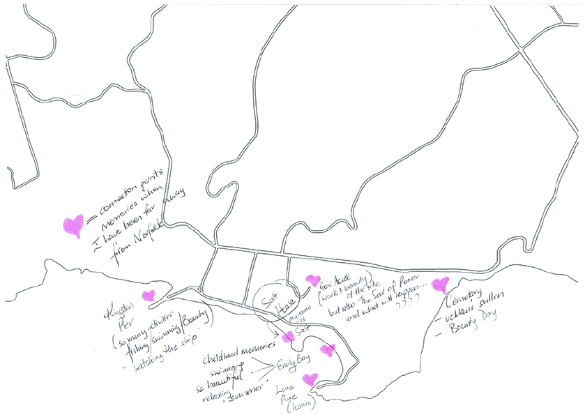
Deb’s Individual Map With Hearts Drawn in Pink Highlighter to Represent “Connection Points”.
Reflective Practice
During and after the mapping activities, attendees would often reflect on the process with the research team. Margaret, for example, spoke about the Emotions key and the selection of words we included:
And this is what you can do with language, of course, you can lead people . . . If you only had positive words [in the key] . . . the whole thing would be, “oh, it’s such a lovely happy place.”
Exactly, whereas we tried to get the spectrum from joyful as the most happy feeling . . . and grief at the very end . . . and then a whole bunch of things that are in between. It’s not even a continuum, is it? Because hostility [in the context of KAVHA] could presumably be connected to things like grief and sadness and hurt. But it’s an offshoot.
Margaret queried Sarah’s connection of hostility with emotions like grief and sadness. For Margaret, grief and sadness are better explained by a connection to how people feel about sites like the cemetery. Hostility, on the other hand, they identified as being characterized by “loss of self control and life and all that sort of thing. . . . Insult fits in there as well.” Margaret ended by observing, “I’m so a word person.” In this exchange, Margaret highlighted that the selection of words in the initial key was important because they did not just orient participants to positive emotions they might feel about Kingston, but instead provided a spectrum of emotions that could be built upon.
Many participants reflected on the difficulty of adequately capturing what Kingston means to them on the maps. During the Routes activity, Mikiela struggled to simplify their engagement with Kingston by sticking with the roads on the map, noting “Wi kud jes fil ieh hoel maep iin anieh.” 17 Tane commented that the Emotions task was “tricky” because “it’s all incredibly important,” making it hard to assign feelings to only a few specific spots or distinguish between one area of Kingston and another. While working on their individual map, Ken explained the challenge of representing the multitude of memories, feelings, and histories associated with Kingston:
There’re so many things that are floating around in there, it’s really hard to put it down on paper . . . the love I have in here [points to their chest] for everything on Norfolk is just really difficult to put down on paper. I might actually put that [on the map].
Pinning down discrete sites of emotion when feelings encompass the whole area emerged as a limitation of the activity. Many contributors encountered this, with Gaye, for example, saying “I am in awe of all of Kingston. So I don’t know how to [represent] that.” Despite this limitation, the activities were illustrative in showcasing how feelings about and connections to this special, treasured place transcend visual or textual representation. Participants overcame this limitation by individualizing the activities to make them their own, collaborating with others to make sense of the task and their ideas, and expressing to us through conversations the shortcomings of the mapping.
In an exchange with Kym, the research team proposed the possibility of including a pop-up mapping activity at an upcoming island event. Kym’s immediate response was positive, but on hearing that it would only involve one of the mapping activities—likely the Emotions task—they identified possible drawbacks:
My only concern . . . [is] if people are only doing negative [emotions], then that’s their feelings, I guess. How they come away thinking about it after they put their feelings down compared to the whole [series of] activit[ies] –
Yeah, that’s a great point.
Because doing—ok, this is where I go [Routes], this is what I do and these are the types of the things that I do [Customary Practices] and this is what’s happening down there and how it makes me feel [Emotions] and then all [these are] incorporated together [individual map].
It’s in context. . .
So, from doing all of them, you walk away, I guess, thinking of the negative and the positives . . . and because we have that sense of belonging and have that attachment to the things that we do on Norfolk, then you lose—you may not get all of that from that feelings [map alone].
That’s true, Kymmy.
That’s really useful.
For Kym, the value of the mapping is in the suite of activities, acknowledging what they provide the participant for thinking through the complexities of their relationship with Kingston. Kym observes some of these valuable nuances may be lost if the Emotions activity is held as a standalone task where contributors would not have had the opportunity to be invited to think about how they are connected to the site beyond emotion. This point also connects to Margaret’s observation about words, with Kym reflecting that because the contributors will not be coming to the activity holistically, they may be oriented toward negative feelings due to contemporary issues and the lack of scaffolding that the Routes and Customary Practices activities provided.
Participants acknowledged that their engagement with the mapping activities would extend beyond the defined time of the workshop, with Margaret, for example, noting “I think I’ve gone where I can go [with the Emotions map, but] I’ll go home and think about [it] a whole lot more.” Ongoing reflections after leaving the workshop led Pat to return at the end of the day to revise some of the language they had included on a sticky note on the Emotions map, where they had commented on the quality of heritage management in Kingston. Pat had reflected on their contribution after leaving the workshop and came to the conclusion that their original wording was too harsh. Coming back to the maps later in the day, they explained to the research team that their original wording may be experienced as hurtful if read by those who worked directly on the site’s management. Pat’s revised statement read: “Shame that the KAVHA area is not maintained to the standard of prior [to] 2016. It’s such a great area.”
On the Value of Conversation
The mapping activities effectively captured some of the ways that our participants understand, relate to, and engage with Kingston as a deeply meaningful historical place and a space for more mundane, everyday practices, both of which are tied to the complex and layered experiences of Kingston as a living heritage site. What was particularly revealing for us as researchers was not just the maps as a finished product, but the process of negotiating the activities with our workshop attendees, trying to create material representations of often immaterial relations. As Sletto (2009) describes: mapping workshops become theaters for the performances of identities, the reading and interpretation of histories, and the production of material and imaginary landscapes that participants consider “theirs.” Mapping is a performative practice in which individuals speak and act their histories of landscapes and belonging, and through these performances, they negotiate their relationships with each other, with space, and with power (p. 465).
As such, the maps are not necessarily simple to interpret as standalone visual data but are best understood in the context of the conversations we recorded. These conversations highlight how participants feel about Kingston as a living heritage site with a rich, fraught, complicated history. For example, the discussions during the Emotions activity showed the multiple interpretations that contributors can have of the same emotion word and, therefore, the complexity of what ends up being represented on the map (and how the map may be interpreted by others). Participants’ collaborative orientation to the maps—being cognisant of others’ labor and the impact their own additions may have on what others had chosen to record on the maps—also meant that the maps do not necessarily convey the popularity or intensity of particular feelings or activities.
Reflected in the findings were Álvarez Larrain and McCall’s (2019) observation that participants can have limited abilities to work with base maps due to not normally viewing sites with an aerial perspective. We quickly learned that the birds-eye view of KAVHA that the map presents is not how workshop attendees conceptualize or understand Kingston. Mikaela’s comments captured above indicate that the inclusion of key sites would have assisted orientation to the map. Álvarez Larrain and McCall (2019) propose that the challenge of working with base maps can be addressed by delivering training workshops prior to holding the participatory mapping workshops. However, Mikaela’s comments also highlighted that how participants conceptualize Kingston differs from its two-dimensional representation, suggesting that training in the use of base maps would not satisfy the depth of understanding, local knowledge, and relationships that shape their connections and attachment to Kingston. Whereas we, the researchers, had been thinking about mapping in terms of specific sites, for our participants the mapping activities were an opportunity to underscore a more holistic approach to thinking about culture, living heritage, and governance, and, subsequently, addressing why safeguarding Kingston is so important. Though the base maps were initially discombobulating for attendees, they quickly adapted to the mapping process with individualized and collaborative approaches that could capture their rich, multi-layered relationships with Kingston. But, while the maps do capture those aspects, it is only through conversation among participants and between participants and researchers that such relationships become apparent. While participatory mapping can overcome the limitations of traditional cartographic practices, the recording of associated conversations is critical if researchers are to more fully tease out what is captured on the maps and why.
Despite the limitations of the maps as standalone visual data, the reflexivity and critiques of contributors during and after the workshops contributed to a deeper understanding, for researcher and participant, of the potential value of mapping for recording the significance of Kingston’s living heritage. As Deb observed, “What an interesting exercise in thinking about that area and what it means. And to us personally.” Dialogues between participants and between participants and the research team inspired a type of collaborative analysis on-the-go, resulting in, for instance, the building of a more representative Emotions key and the adaptation of activities to add words rather than only colored lines, stickers, and drawn symbols. Such dialogues also assisted the research team to better understand aspects of the research design that they had taken for granted. Kym’s comments, for example, about the importance of the sequencing of mapping activities and how this informed the project’s outcomes prompted us to think more deeply about the suitability of maps to be used as activities outside of the workshop context. Wainwright and Bryan (2009) suggest “map-making” can be approached “as a political . . . process,” not just a “technical” one (p. 170). What we created with participants was not limited to the data on the maps themselves. Indeed, as this article highlights, some of the most important insights for the project came from the conversations sparked by the process of thinking about space, talking about place attachment, sharing memories, and questioning the conditions under which the maps were created and why we as researchers were doing what we were.
Conclusion
The maps created as part of the Reimagining KAVHA project demonstrate the special connection that Norfolk Islanders have to their home and the strong sense that Kingston belongs to them (was and is theirs, “auwas”/ours). The mapping process highlighted the deep love and pride participants have for Kingston, but also their fears that the integrity of this treasured place was under threat because of ongoing injustices related to heritage management practices and governmental affairs more broadly. Taking a critical cultural justice inquiry approach, the participatory mapping does not function simply to create an inventory of things and places but to reveal the complexities of relationships to space, custodianship of heritage, and politics of belonging and ownership.
What is clear from this article’s findings and discussion is that the maps produced during the project’s participatory mapping workshops can only tell a partial story of attendees’ relationships with and experiences of Kingston. In line with Kim’s (2015) suggestion that critical cartography must engage in “deeper social engagement” (p. 215) rather than merely creating a visual representation of knowledge, we were aware from the outset that the value of the maps would be in their being placed alongside other forms of storytelling which capture the many nuances of people’s long engagement with Kingston. The project’s Reimagining KAVHA zine series, in which the maps were published, was critical for us to fulfill this function of deeper social engagement. By way of this series of eight zines, the maps are situated in the context of participants’ memories and stories of Kingston (see Figure 9) and views of its management that were produced through interviews, zine-making workshops, and independent submissions. The editorials of the three mapping-focused issues of the zine series added more specific context including incorporating brief snippets of conversations from the mapping workshops (see Figure 10). By situating the maps alongside a tranche of contributors’ stories told on their own terms, they become more impactful meaning-making tools for the community and other stakeholders. Rather than producing a fixed sense of place, their placement in the zines ensures the maps become part of a dynamic storying of Kingston’s past, present, and future. The mapping zines also have their own “afterlives” (see Baker & Cantillon, 2022; Radway, 2011) that further facilitate engagement with their content, offering themselves as resources for education and activism or spurring new dialogues and the sharing of memories and knowledge beyond the bounds of this project.
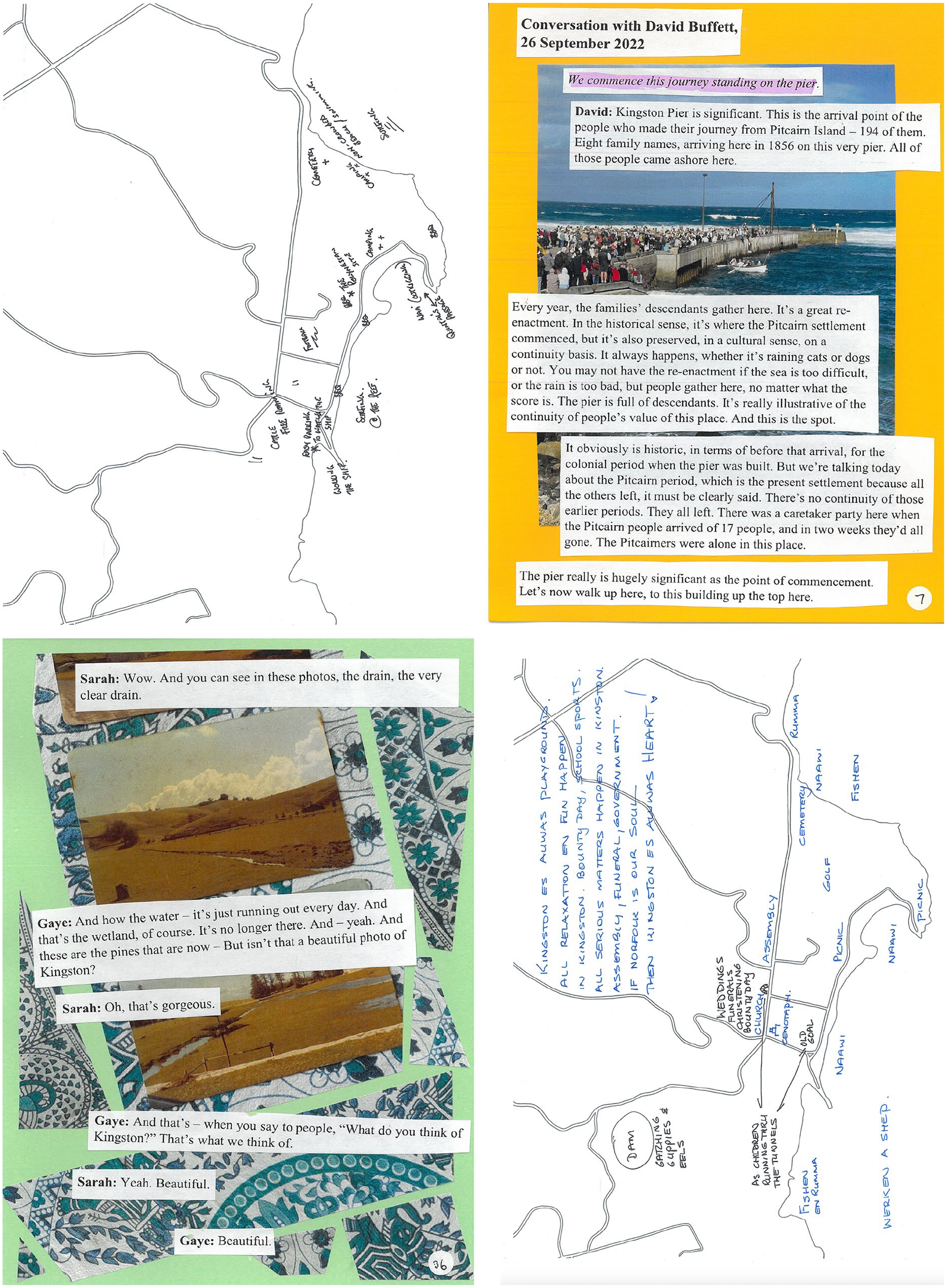
Adjacent Pages in the Wathing Yu Bin Duu?: Mapping Customary Practices in Kingston Zine (Cantillon et al., 2023c, pp. 6–7; Top) and Watawieh Yu Fiilen?: Mapping Emotions in Kingston Zine (Cantillon et al., 2023b, pp. 36–37; Bottom) Showcase How the Mapping Activities Appear Alongside Conversations (Interviews) Conducted at Other Points During the Project.
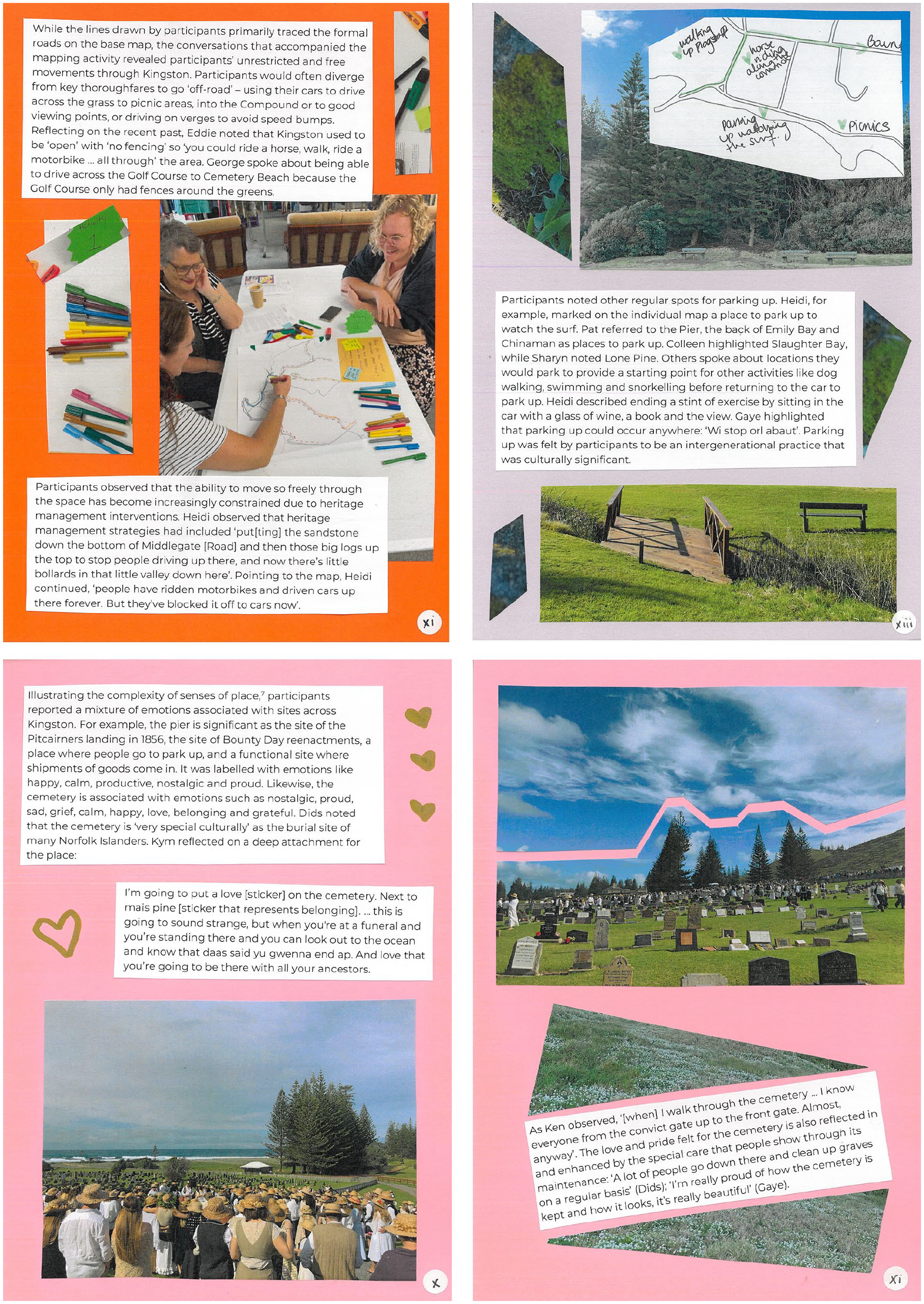
The Zine Editorials Draw on Quotes From the Mapping Workshops to Contextualize the Maps that Follow. Top Left: Defi Ala Daefi?: Mapping Routes in Kingston (Cantillon et al., 2023a, p. xi). Top Right: Wathing Yu Bin Duu?: Mapping Customary Practices in Kingston (Cantillon et al., 2023c, p. xiii). Bottom: Watawieh Yu Fiilen?: Mapping Emotions in Kingston (Cantillon et al., 2023b, pp. x–xi).
Critical mapping techniques are not participatory, democratizing, or ethical by default. Being guided by critical cultural justice inquiry enabled us to embed reflexivity, flexibility, and collaboration into our mapping methodology. The ongoing reflexivity of dialogues between us and the participants—which proved to be critical to understanding the content of the maps—was facilitated by and enabled genuine participation and collaboration. At each step of the mapping process—from designing the activities to running the workshops and publishing the zines—we, the researchers, sought to be reflexive about our own choices (aesthetic or otherwise) and the aftermath of the mapping endeavor. In particular, we learned the most from remaining open to and encouraging participants’ adaptations and critiques during the workshops themselves, and by putting more emphasis on the mapping process rather than on the maps as products. Being committed to participatory approaches means supporting participants’ senses of agency and embracing what unexpected insights reveal about relationships to place and the efficacy of chosen methods.
Footnotes
Declaration of Conflicting Interests
The author(s) declared no potential conflicts of interest with respect to the research, authorship, and/or publication of this article.
Funding
The author(s) disclosed receipt of the following financial support for the research, authorship, and/or publication of this article: This work was supported by the Australian Research Council [SR200200711].