
Abstract
Long-held ideas concerning early Neolithic Linearbandkeramik (LBK) settlements in central Europe have been thoroughly challenged in recent years, for example, regarding their internal organisation or the use-life of individual houses. These topics have now also been addressed with the help of large radiocarbon (14C) datasets. In the light of this discussion, we present findings of our ongoing research at Vráble in south-western Slovakia. Intensive prospection by fieldwalking, geophysics and sedimentology, complemented by targeted excavations and archaeobotanical investigations, aims to unravel social and temporal relationships between three adjacent LBK settlements. A total of 23 of the c.300 houses revealed by geophysical prospection have been dated. Bayesian chronological modelling of this dataset, comprising 109 14C ages from 104 samples, indicates that the three LBK settlements at Vráble coexisted, and that overall the LBK settlement lasted for c. 200–300 years. Our results imply a ‘short’ use-life for individual houses (median c.20–30 y), suggesting that relatively few houses were inhabited simultaneously. Our data suggest that the overall LBK population at Vráble might have increased over the course of occupation, but probably never exceeded 200–300 individuals, based on the number of houses that could have been occupied contemporaneously. We compare the Vráble evidence with Bayesian chronologies for other LBK sites, and discuss the implications of these findings for models of population agglomeration and recognising the environmental impact of early farming communities.
Keywords
Introduction
Early Neolithic horticulturalists in Central Europe certainly transformed their environment and contributed to the creation of a cultural landscape, but to recognise the environmental impact of early farming, it is essential to have some idea of both the population size involved and the longevity of settlements. These parameters are closely linked through investigations of the scale, density and temporal dynamics of Linearbandkeramik (LBK) settlements. Recent fieldwork at Vráble, in south-western Slovakia (Figure 1), allows us to challenge assumptions often made when discussing these issues. Large-scale settlement plans, based on excavations or – as at Vráble – geophysical prospection, allow better visualisation of the spatial configuration of LBK settlements, particularly of the number of longhouses in each settlement area. With regard to temporal dynamics, several issues have to be distinguished:
- The overall dates and life spans of settlements, which are pertinent to the number of settlements occupied in a region at any moment in time. Recent case studies have produced divergent estimates of LBK settlement life spans, from very short (10–35 years at 68% probability, Jakucs et al., 2018), to longer (120–155 years at 68% probability, Jakucs et al., 2016) and very long (290–410 years at 68% probability, Oross et al., 2016 [2013]).
- The internal chronology of settlements, if not all areas or houses were occupied simultaneously. LBK settlements rarely provide detailed stratigraphic sequences, and conflicting interpretations of how they expanded or contracted are therefore plausible. In terms of population trajectories, whether different areas were occupied consecutively or concurrently, or whether the number of houses occupied increased over time, are important questions which overall site chronologies do not address.
- The life spans of individual houses: while short life spans of c. 25 years were traditionally assumed (Whittle, 2012: 195f), it was recently suggested that LBK houses could have been used for up to 100 years (Schmidt et al., 2006). The longer house life span implies that a settlement had four times as many inhabitants as the shorter life span, other things being equal.
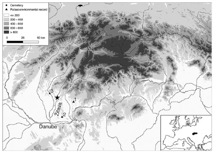
Terrain map of Slovakia and the surrounding region, showing the location of Vráble (star), palaeoenvironmental sequences spanning the LBK at Santovka (1) (Šolcová et al., 2018), Nová Vieska (2) (Jamrichová et al., 2014) and the LBK cemetery at Nitra (3).
By analysing data from Vráble, we estimate the overall settlement period, the life span of single houses and, thus, the population size. These results can be used to estimate the impact of early Neolithic settlement on the natural environment of the Upper Žitava Valley.
The site
Vráble-Veľké Lehemby lies on the edge of the Danube plain in south-western Slovakia, on several terraces south and south-east of the town of Vráble, separated by the brook Kováčovský potok. This stream flows into the Žitava River, in the immediate vicinity of the site. Before LBK settlement, a mixed oak forest probably covered the terraces of the Žitava (Jamrichová et al., 2014; Šolcová et al., 2018).
Research on the early Neolithic site, a cluster of three settlements (northern, south-western, south-eastern), began with extensive geophysical surveys from 2009 to 2012 (Furholt et al., 2014). Targeted excavations took place in 2012, 2013, 2014, 2016 and 2017, which showed the usual spectrum of LBK features and finds, that is, houses with lateral pits containing most of the finds, as well as postholes and storage pits. The finds mainly comprised pottery and burnt clay, chipped stone and bone artefacts, and groundstone artefacts such as millstones, rubbing stones or adzes. In relative chronological terms, the pottery belongs to the Želiezovce group, that is, the later phase of the local LBK (Pavúk, 2007). Thus, the Vráble settlements might overlap chronologically with the LBK cemetery at Nitra (Pavúk, 1966: Figure 1), c. 20 km to the west, where the latest graves contain Želiezovce pottery. During the 2017 season, an extensive coring programme was carried out in the south-western settlement, with the aim of obtaining datable samples from lateral pits of as many houses as possible.
The geophysical surveys provide an excellent overview of the shape and size of all the LBK settlement areas (Figure 2). Only the north-western corner of the northern settlement is now built over. The characteristic lateral pits, which are clearly visible in geomagnetic images, also provide a detailed picture of the number, spacing and orientation of houses, even if not all houses have necessarily been detected. The northern settlement covered an area of c.11.9 ha, on which at least 130 houses stood. In the south-eastern settlement, 92 houses were distributed over 14.0 ha. At least 82 houses can be identified within the 8.6 ha south-western settlement, which uniquely has a surrounding ditch interrupted by several entrances, enclosing a total of 14.5 ha. From the shape of the ditch, it appears that the south-west settlement was initially rectangular, and that its north-eastern part was added later.
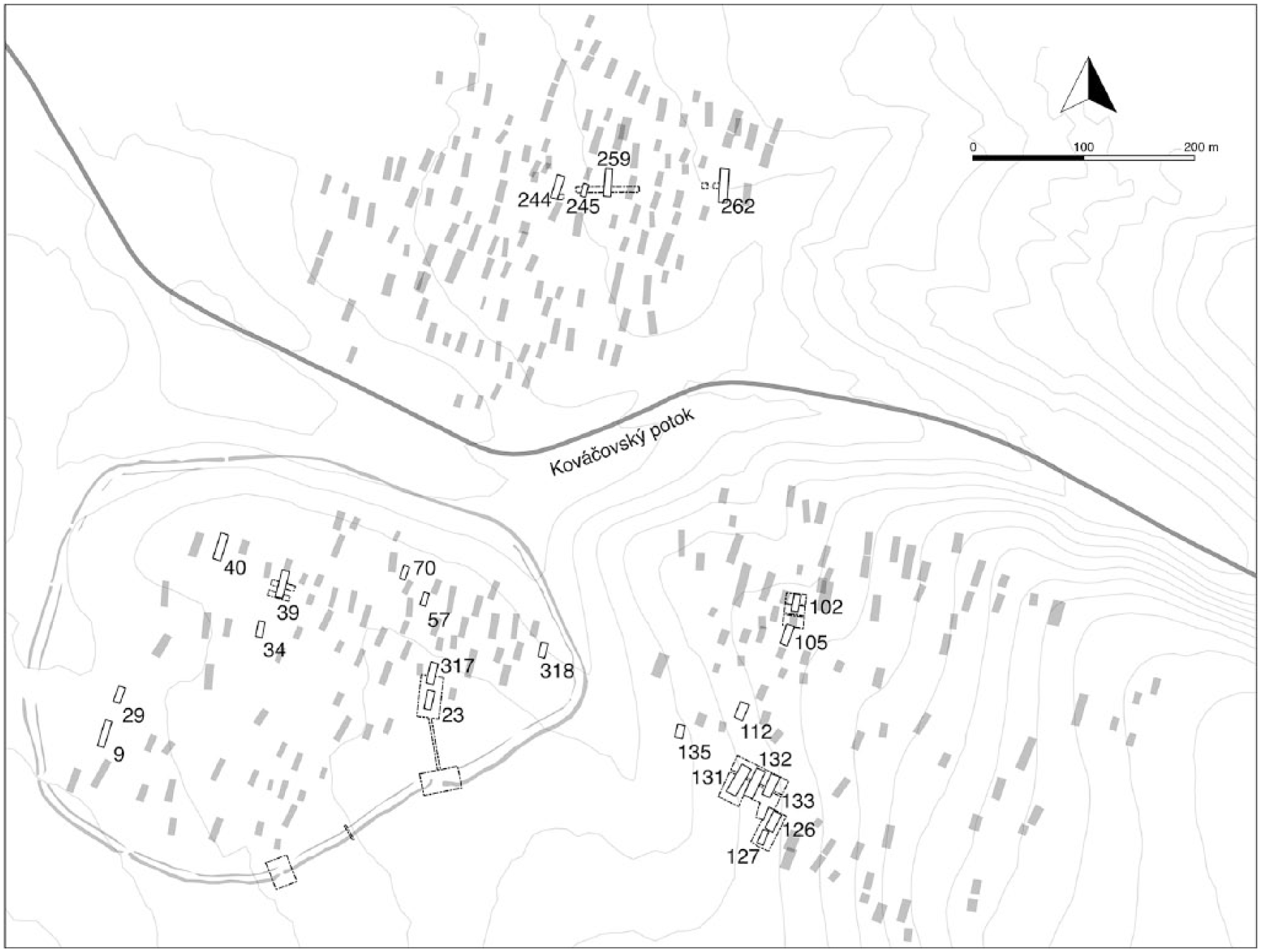
Plan of the LBK settlements at Vráble, derived from geomagnetic images, showing houses dated in this paper. Contour interval: 1 m.
Paleoenvironmental context
The only palaeoenvironmental data from Vráble are plant macrofossils from the excavations, which are not yet fully analysed. Nowaczinski et al. (2015) analysed sedimentological changes in the Žitava near Vráble, but a waterlogged site spanning the LBK has not been found, so there is no relevant local pollen record. The closest multi-proxy palaeoenvironmental records are from near Santovka, 35 km east of Vráble (Šolcová et al., 2018), and Nová Vieska, 40 km south of Vráble (Jamrichová et al., 2014) (Figure 1). Nowaczinski et al. (2015) interpreted an apparent hiatus in alluvial sedimentation in the Žitava valley from 14500 to 6500 cal. BP as reflecting constant vegetation cover, so the Vráble LBK settlements are not visible as erosion events (indeed, Nowaczinski et al., 2015 found no charcoals dating to the LBK period in their cores). Likewise, despite there being LBK settlements at Santovka, the arboreal/non-arboreal pollen ratio only decreases at c. 6650 cal. BP, around the time that erosion increased in the Žitava valley. At Nová Vieska, a clear decrease of tree pollen is only seen after 5960 cal. BP, but a charcoal peak and an increase of shrubs and trampling indicators were detected around 7400 cal. BP, which we might link to the start of the LBK locally, although the proposed date is 100–200 years too early.
Research questions
Temporal dynamics refers to any archaeologically visible activity with a temporal dimension, such as evidence of house rebuilding or recutting of lateral pits, the sequence and longevity of individual houses or settlements, temporal patterns in the location and orientation of new houses, and change over time in the rate of construction of new houses and abandonment of existing houses. Any or all of these issues could be discussed if enough reliable 14C dates are available from samples securely associated with a large and representative set of features. We also aim to consider the implications of dating results from Vráble, both for the potential local environmental impact of LBK activity, and more generally for the validity of assumptions about temporal dynamics at LBK sites in general, and the methods used to construct absolute chronologies for large flat settlements. While we do not assume that every LBK settlement followed the same trajectory, in terms of longevity, population growth and so on, we want to understand how the methods applied (e.g. sampling strategy and chronological modelling techniques) could produce different narratives for the same site, and therefore whether our perceptions of temporal patterns at LBK sites are reasonably robust, and whether it is possible to make useful generalisations.
One major current discussion concerns the organisation, growth and development of LBK settlements. The sampling strategy for the south-west settlement (see below) was originally conceived in order to investigate these issues. For several decades, the Hofplatz (house ward) model was accepted without criticism (Zimmermann, 2012), based on the idea that a small group – presumably a family – lived at a Hofplatz for several generations, regularly building new houses around the original Hofplatz, although inhabiting only one house at a time. In recent years, the Hofplatz model has been juxtaposed with the thesis of the construction and organisation of LBK houses in rows (Rück, 2013). There have also been attempts to combine these two basic theses. It would be desirable to test these models because conclusions from the Hofplatz model have influenced the interpretation of archaeological data, for example, regarding the contemporaneity of individual houses or the affiliation of individual pits to specific houses or wards.
Simulation modelling of the Vráble south-west settlement showed that with a sufficient number of dated houses, dated following a spatially randomised sampling strategy, it would have been possible to test versions of the row model, which predicts that there should be a vector (e.g. from east to west) along which houses were built successively; another alternative, of concentric growth from a point of origin, could also be tested. The Hofplatz model is the most difficult to model, as the starting point of Hofstellen is arbitrary. If we suppose that each house had a life span of 25 years, and that a settlement was occupied for 200 years, there should be clusters of up to eight houses per Hofstelle, within which only one house was occupied at any point in time.
Unexpectedly poor recovery of suitable dating material, combined with poor bone preservation, means that these questions cannot currently be answered, and that this paper therefore focuses on the following:
- The overall chronology of LBK activity at Vráble
- Whether the three settlement areas were fully contemporaneous, overlapped in time, or followed each other, with or without hiatuses
- The life span of each settlement area
- The life span of individual houses in all three areas
- Estimating the number of houses occupied at any point in time
- Detecting any trends in the number of houses occupied
- Estimating the population and land requirements of the Vráble settlements.
In addition, we compare the Vráble chronology, developed here on the basis of new 14C dates for 104 samples, with recently published Bayesian chronological models for three LBK sites in Hungary, which were excavated in advance of highway construction using different fieldwork methods and modelling decisions.
Methods and materials
Excavation
In all, 14 houses, mostly in the northern and south-eastern settlements, were partially excavated by hand after mechanical removal of ploughsoil (Figure 2). Where possible, excavation followed natural stratigraphy, but where natural strata were not visible, or natural layers were more than 10–15 cm thick, artificial layers 10–15 cm thick were excavated. Most bones taken for 14C dating were located three-dimensionally to within 1–2 cm. Except for two grains from a storage pit, all other 14C samples were taken from long lateral pits. Ideally, only articulated bones would have been selected for dating, as articulation indicates that bones were deposited where they were found before soft connecting tissues had decayed. However, in general, bone preservation at Vráble is very poor, and we cannot argue for articulated deposition of any of the bones dated for this study.
Coring of the south-west settlement
The 2017 coring campaign aimed to maximise the number of houses in the south-western settlement that could be dated by at least three 14C samples. Based on test coring in 2016, in which c. 60% of cores in lateral pits yielded datable material, it was estimated that drilling 5–7 cores from each house would allow more than 20 houses to be dated, assuming that up to 200 cores could be drilled in total (Figure 3).
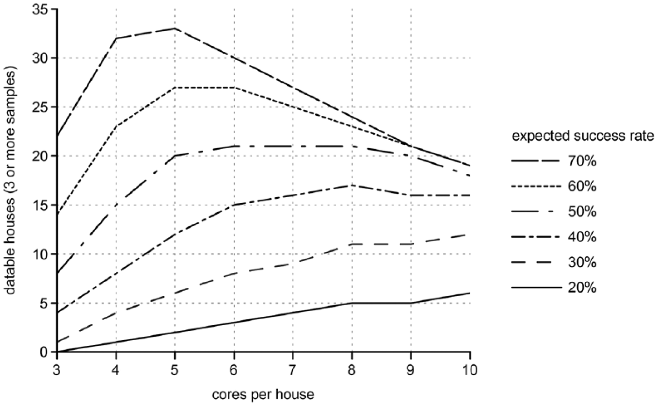
Estimated number of houses yielding three or more samples suitable for 14C dating as a function of the number of cores drilled per house, based on the expected success rate (% of cores yielding datable material), if 200 cores are drilled altogether. High expected success rates favour more extensive drilling (i.e. fewer cores per house); low expected success rates favour more intensive drilling of fewer houses.
A total of 34 of the 82 recognised houses in the south-west settlement were therefore selected using PostgreSQL’s ‘random’ function, providing relatively even coverage of the settlement area (Figure 2). Five potential boreholes per house were identified. The lateral pits to be cored were selected to avoid potential double dating of close-lying houses. In the field, three cores were drilled per house to see whether it was promising or necessary to drill the two further boreholes. In all, 134 cores were drilled in lateral pits associated with 34 houses (3–5 per house).
Drilling was carried out with a percussion drill with liner tubes 5 cm in diameter, reaching depths of 1–2 m. The liner tubes were opened with a rotary tool, documented and then from one-half each recognised layer was sampled, except the topsoil and virgin soil. These samples were wet-sieved (0.5 mm mesh), and from the dried residue, bones and plant macro-remains such as charred grains and charcoals were picked and determined as far as possible.
Laboratory methods
A total of 104 unique samples were dated by four laboratories: the Poznan Radiocarbon Laboratory, Poland (Poz-, 65 samples), the Centre for Isotope Research, Groningen University, the Netherlands (GrM-, 22 samples), the Royal Institute for Cultural Heritage, Brussels, Belgium (RICH-, 17 samples) and the Leibniz-Laboratory, Kiel, Germany (KIA-, 5 samples, which were replicates of bone samples also dated by Groningen or Brussels). The last three laboratories were only used to date samples from the south-western settlement, whereas Poznan dated 10 samples from the northern settlement, 39 from the south-eastern settlement and 16 from the south-western settlement.
Pretreatment
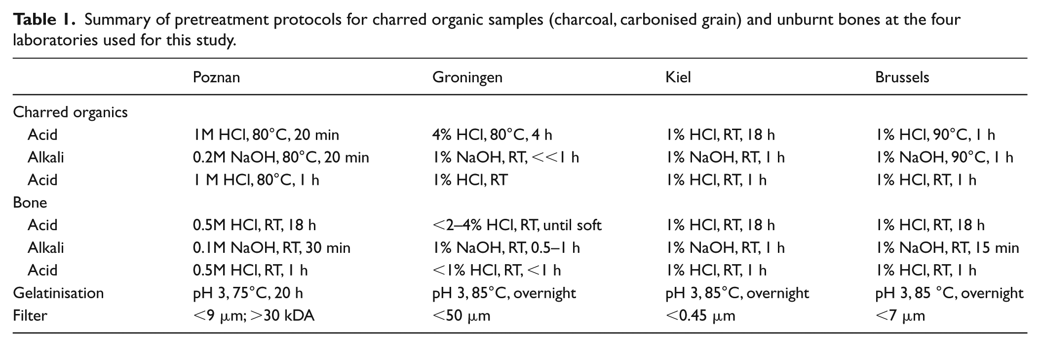
Chemical pretreatment is used to isolate the most robust original organic component of each sample and remove soluble contaminants from the burial environment. Samples were extracted following standard acid–base–acid protocols, which varied only slightly between laboratories (Table 1). At Poznan, the filtered collagen is ultra-filtered following Brock et al. (2010b) to remove degraded low-molecular-weight collagen fragments. At all laboratories, the extracted collagen is dried and weighed, allowing the extraction yield as a percentage of the starting weight to be calculated.
Summary of pretreatment protocols for charred organic samples (charcoal, carbonised grain) and unburnt bones at the four laboratories used for this study.
Measurement
A sufficient quantity of each extract was combusted to give CO2, which was reduced to graphite for 14C measurement by accelerator mass spectrometry (AMS). Again, the basic procedures at each laboratory are similar. At Groningen, an elemental analyser is used to combust the extract, allowing direct measurement of its carbon and nitrogen content, and for stable isotope ratios (δ13C and δ15N) to be measured immediately on an isotope ratio mass spectrometer (IRMS). The Brussels laboratory also reports EA-IRMS measurements by a collaborating laboratory data on collagen extracts.
At Poznan, 14C ages are measured either on an NEC 1.5 MV Pelletron AMS used since 2001, or a second compact NEC system installed in 2013. The Kiel laboratory uses a 3 MV HVEE Tandetron AMS, in operation since 1995 and upgraded in 2015. Brussels and Groningen use 195.5/180 kV IonPlusMicadas AMS systems, installed in 2013 and 2017, respectively. All the AMS systems simultaneously measure 12C, 13C and 14C ion currents from each graphite target; the 13C/12C ratio (AMS δ13C) is used to normalise the 14C current for natural and instrumental fractionation, and thus to calculate conventional 14C ages. The reported 14C age errors incorporate uncertainties in sample measurement, standard normalisation, instrumental background, blank correction and additional uncertainty arising from sample pretreatment, based on long-term experience with laboratory standard and known-age samples of similar materials.
Results
Spatial coverage
Lateral pits of houses in the southern part of the south-western settlement, where most cores reached sterile ground at a depth of only 1 m, were generally very poor in potential samples, perhaps because of stronger erosion in this area. Although charcoal occurred in many cores, the vast majority was oak of undetermined maturity, which is unsuitable for dating because of the long potential lifetime of an oak tree. Material suitable for dating was obtained from only 7 of the 34 houses sampled by coring in the south-western settlement, and the simulation shown above was therefore far too optimistic. Samples were available from three houses excavated in 2012 and 2017. Of the 82 houses of the south-western settlement, 10, that is, 12%, were therefore dated.
Datable material was available from four houses of the northern settlement excavated in 2014, and seven houses in the south-eastern settlement excavated in 2013 and 2016; a single charcoal sample was obtained from test coring of a further two houses in the south-eastern settlement. Overall, datable material was obtained from 23 of the 304 houses visible in the magnetic image, or 8% (Figure 2).
Radiocarbon
Results from all the dated samples are given in Table 2. Six plant samples (macrofossil or charcoal) date to long after the early Neolithic, and one dates to the late Mesolithic; these results can be omitted from LBK chronologies. 1 All other plant remains (n = 22) gave 14C ages between c.6300 and 6100 BP, equivalent to c.5250–5050 cal. BC. There is no reason to doubt the accuracy of these results, or the assumption that these samples were associated with the LBK occupation.
Radiocarbon results, Vráble. Each sample consisted of a single fragment of bone or charcoal, or a single plant macrofossil.
Most of the 75 dated bone samples also gave 14C ages between 6300 and 6100 BP (n = 40), but a significant proportion (n = 21) gave 14C ages between 6100 and 6000 BP, or between 6000 and 5800 BP (n = 7). 2 These samples may (in theory) all be associated with LBK occupation. All four laboratories reported some bone 14C ages below 6100 BP, and the same pattern is seen in all the three settlements. Bones may be skewed towards younger 14C ages than plant remains because of changes in the subsistence economy, but it is much more plausible that bones were affected by diagenesis in ways that plant remains were not, because collagen yields were often poor (a significant number of bone samples failed altogether). All bones dating between 6000 and 5750 BP, and almost half of those with 14C ages between 6100 and 6000 BP, yielded <1% collagen, the threshold suggested by Dobberstein et al. (2009) and Brock et al. (2010a) as a minimum requirement for reliable isotopic measurements (Figure 4).
14C ages (1σ errors between ±25 and ±40 in almost all cases) of bones from the LBK settlements at Vráble, by collagen yield classes (% of starting weight).
Nevertheless, over a third of bones with 14C ages of 6100–6000 BP yielded >2% collagen, and 30% of bones with 14C ages >6100 BP yielded <1% collagen, so we cannot simply apply an arbitrary collagen yield limit. Collagen yield can vary according to laboratory extraction protocols. The ultrafiltration method used to remove low-molecular-weight fragments at Poznan must reduce overall yields, but the 14C age of the remaining higher molecular weight fragments is assumed to be more reliable. Arbitrarily applying a 1% yield threshold would mean excluding around half of the Poznan results, but almost none of those from the other laboratories that did not use ultrafilters.
A second criterion commonly applied to evaluate isotopic data from collagen is whether its atomic C/N ratio is between 2.9 and 3.6 (DeNiro, 1985). The Brussels and Groningen laboratories, which measure %C and %N in the collagen extract, automatically reject dates if C/N>3.6. However, the true C/N ratio in mammal collagen falls within a much narrower range, of 3.16–3.32 (Szpak, 2011), and if the C/N ratio in an extract is really 3.6, c. 10% of the carbon could be exogenous. At Vráble, 10% modern carbon contamination would mean 14C age offsets of up to 800 years, so the level of contamination required to produce 100–200-year offsets would not necessarily lead to unacceptable C/N values. However strictly the C/N criterion is applied, it can only be applied to the Brussels and Groningen dates, and therefore to south-west settlement dates.
Collagen stable isotope (δ13C and δ15N) IRMS measurements are available for bones dated by Brussels and Groningen, and for some of those dated at Poznan, and are shown in Figure 5. In terms of validating the 14C ages, these results are unhelpful, as most bones were too fragmentary to identify to species, and the normal ranges of collagen isotope values from domestic animals in this region and period are unknown. There is no apparent relationship between 14C age and either isotope value.

Stable isotope data (permille) from dated collagen extracts. Circles: indeterminate bone. Dots: large mammal (e.g. cattle, horse). Diamonds: cattle. Asterisks: sheep/goat.
Given these issues, five bones with a range of collagen yields were replicated in Kiel. In two cases, the paired results are statistically consistent, as expected (Table 3). In one case (bc14_340_1), the collagen yield was much lower in one fragment than the other, and gave a much lower 14C age. In two cases (P30135-1 and KNRC221112-1), collagen yields were similar, yet the paired 14C ages were significantly different. The two lowest 14C ages (RICH-25476, KIA-52747) can be rejected on the basis of collagen yield, but neither result for P30135-1 is obviously wrong, and it is true that 14C age may lie between the two measurements.
Results from independent replicate dating of animal bones, Vráble south-west settlement.
Given the limited supporting evidence for many samples (i.e. acceptable collagen yield and %C/%N), differences in the overall pattern of 14C ages between bone and plant samples, and the difficulty of replicating bone dates, a significant proportion of bone dates that appear to belong to the LBK phase must be misleading, even if most bone dates are reasonably accurate. The only data available to predict which dates might be more or less reliable are collagen yields, and in our interpretation (see below) we give greater weight to results from bones with higher yields.
Discussion
Taphonomy
Most samples dated were cultivated plant macrofossils or animal bones, interpreted as food waste discarded in lateral pits during the occupation of the adjacent house. While it is usually taken for granted that the long pits flanking LBK houses were used as clay extraction pits and were subsequently filled with waste, their function and the filling processes are still debated (Petrasch and Stäuble, 2016; Wolfram, 2013). However, recent research (e.g. Allard et al., 2013) as well as our own excavations (Müller-Scheeßel et al., in press) have shown that the debris is recurringly patterned and thus reflects activities having taken place during the existence of the corresponding house. Charcoal in the lateral pits may come from fuel used in the same occupation episode, but firewood could have included, for example, old timber from abandoned houses. It is difficult to distinguish recutting episodes within lateral pit fills, and in theory these pits may have been emptied regularly, so that datable material is derived mainly from the final phase of use. It is equally possible that pits were extended horizontally as required, and that by coring along the length of a lateral pit it is possible to obtain samples spanning the whole occupation. In some cases, the upper levels of lateral pits may have been eroded by ploughing or truncated by mechanical excavation, and here the remaining samples probably underestimate the house life span. Aside from one Mesolithic charcoal (Poz-90168, 7030 ± 40 BP), the oldest samples include cereal grains, which should be associated with the LBK, as agriculture appeared in this region in the early Neolithic. The domestic status of fragmentary animal bones is less obvious, but no bone samples gave older dates than the oldest cereals.
Interpreting bone dates
Considering the questions raised above, bone 14C ages from Vráble must be used cautiously in Bayesian chronological models. OxCal’s Outlier_Model function (Bronk Ramsey, 2009b) is designed for situations in which we suspect that some dates are misleading, but are not sure which. Outlier_Model parameters can be set according to our understanding of the potential problems. A ‘type r’ Outlier_Model applies when calendar dates are relevant (e.g. samples are not residual or intrusive), but 14C ages may be misleading because of contamination. We have used the default R_Scaled model, which envisages 14C-age offsets drawn from Student’s t distribution; that is, we assume that most results will be very close to the correct 14C age, but a few will be much younger or older. We used collagen yield to set an arbitrary prior probability that each result is misleading (Table 4).
Prior probabilities assigned that 14C ages of bone samples are misleading (‘type r’ outliers, Bronk Ramsey, 2009b).
These prior probabilities give more weight to better-preserved samples, and little statistical weight to samples yielding <1% collagen. Depending on sample 14C ages, and their relationships with other samples in the model, OxCal’s posterior estimate of the probability that each result is misleading may be higher or lower than the prior probability. If the posterior probability was much greater than the prior probability, we concluded that either the 14C age was unreliable, or that the sample was not associated with the adjacent house, and omitted it from the site chronology.
Chronological modelling
Model specification
Bayesian chronological models incorporate two types of relative dating information. Informative priors typically require some samples to be older than others; for example, a stratigraphic burial sequence implies a strict date order. Uninformative priors impose a statistical distribution on the dates of events that are not regarded as independent, for example, the assumption that potential 14C samples are uniformly distributed in date between the start and end of the period of interest. Without such assumptions, we could not use the scatter of 14C results to estimate the dates of these parameters.
Our Vráble models do not contain informative priors, except that samples associated with House 132 are required to be older than those from Houses 131 and 133, which are stratigraphically later. We are interested in when each house was built and abandoned, so where there are at least three usable 14C dates from one house, we use the OxCal Boundary function to estimate the dates of the beginning and end of its occupation. When there are only two usable dates for a house, we use OxCal’s First and Last functions to give an impression of its longevity.
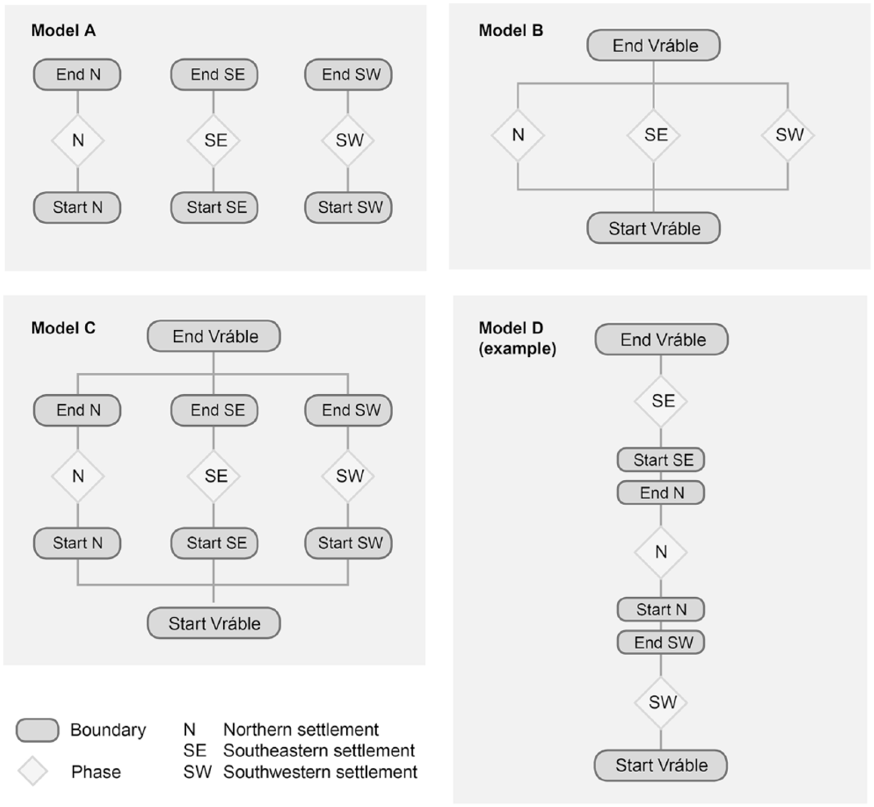
A priori, chronological relationships between the three settlements can be modelled in several ways:
The three settlements might represent independent, potentially overlapping phases of occupation; thus, we should focus on dating the construction and abandonment of each settlement.
The three settlements might have been fully contemporaneous (even if not all houses within them were occupied simultaneously) – in which case, the entire LBK period at Vráble represents a single phase of occupation; the main challenge is to detect any trends in the number of houses in use.
The three settlements might not be chronologically independent, but the clustering of houses into three settlements is probably indicative of significant changes in the intensity of LBK occupation at Vráble, which are incompatible with Model B.
The existence of three adjacent settlements might imply that only one was occupied at any point in time; thus we should test the potential sequences of settlements and the potential hiatuses between them.
Each interpretation implies different uninformative priors (Figure 6), and may require the exclusion of a different subset of results to reach a satisfactory fit between the 14C data used and the model structure. In this paper, we only present Models A and B, as Model C, which essentially combines Models A and B, provided no additional insight, and no permutations of Model D are permitted by the 14C results.
Schematic representation of uninformative prior information embodied in potential chronological models of the Vráble LBK settlements. The terms Boundary and Phase are OxCal CQL functions (Bronk Ramsey, 2009a). In each model, time proceeds from the bottom to the top of the diagram.
We regard the dates of samples from the south-western settlement as more reliable and more representative than those from the other two settlements, because of the following reasons:
- Randomised selection of houses for coring reduces the risk that the dated houses are unrepresentative.
- Collagen yields were generally better, and almost half the dated samples were charred grains, not bones.
- Bones were dated at four laboratories, with supporting %C and %N data for most samples.
One check on our models, therefore, is whether including the northern and south-eastern settlement dates dramatically affects model output for the south-western settlement, compared with modelling the south-west settlement dates separately. The collagen Outlier_Model parameters were first tested on data from the south-west settlement only, and accepted when a stable chronology emerged, which was not affected by the addition of bone dates from the other settlements.
A second aspect of the modelling process was the manual removal of samples with dates that are incompatible with their position in the model (outliers sensu (Bronk Ramsey, 2009b)). The collagen Outlier_Model only suggests which results appear to be misleading (because the posterior estimate that the date is an outlier is significantly higher than the prior probability). When the OxCal dynamic index of agreement, Amodel, is unacceptably low, posterior estimates of the Outlier_Model parameters show that large 14C-age offsets are required for the dates of outliers to be compatible with the model structure. As outliers are removed, Amodel increases until a threshold value of 60% is reached. At this point, the prior and posterior probabilities that each result is an outlier are very similar (Figure 7) and the Outlier_Model serves primarily to give greater weight to better-preserved samples, rather than to ‘correct’ the calibrated dates of samples with misleading 14C ages. The posterior distributions for the Outlier_Model parameters also indicate that large 14C age offsets are not necessary after the misfitting dates are removed (Figure 8).
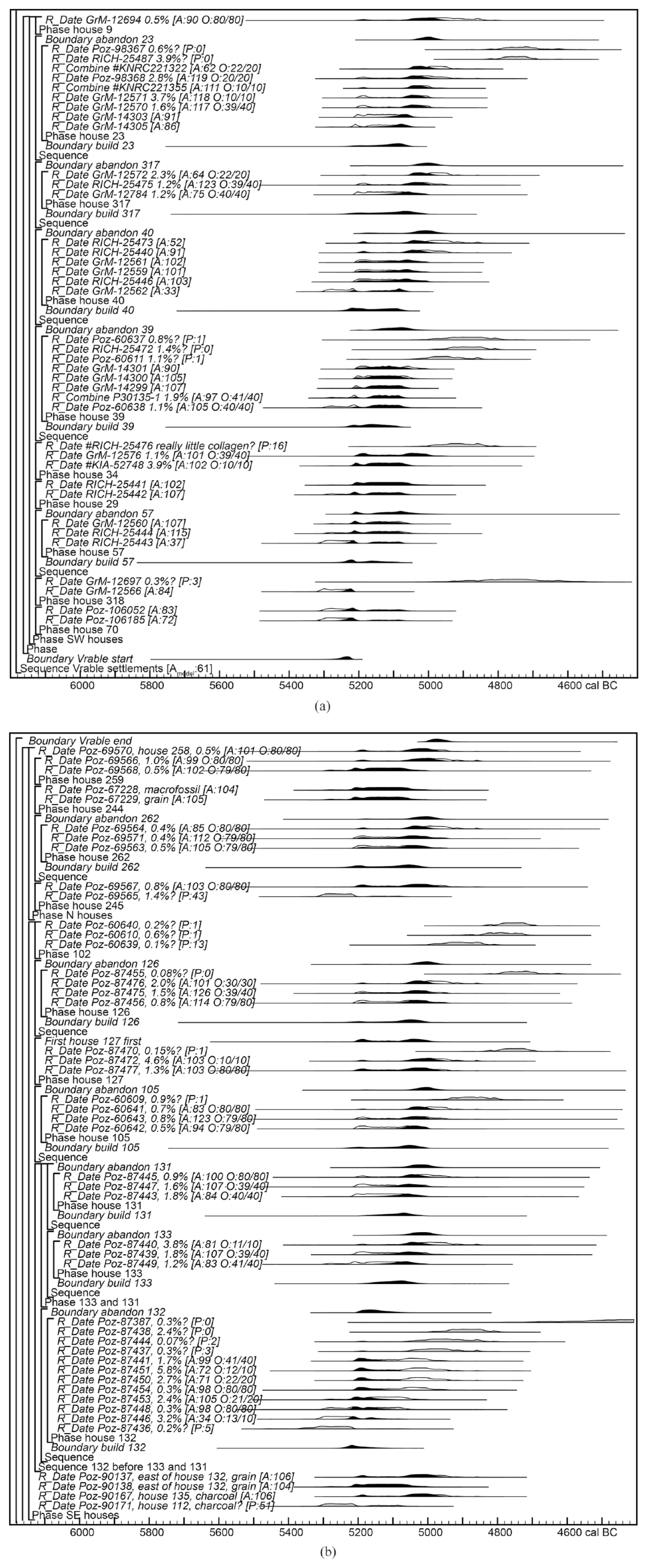
Model B dates from the south-western settlement (a) and the northern and south-eastern settlements (b). Brackets and OxCal CQL keywords define the model structure. Dates used in the model have two probability distributions: in outline, the result of simple calibration; solid black, the model’s posterior density estimate of the date of the sample. For these results, an individual index of agreement (A) compares the posterior density estimate with the simple calibrated date. For bone samples, labels also show the collagen content (%wt) and posterior/prior estimates (O) of the probability that the result is an outlier. Grey distributions are simple calibrations of results which have been omitted from the model as radiocarbon outliers or stratigraphic misfits, for which OxCal calculates a probability (P) that the result fits the expected age of the sample, given its notional position in the model. Solid black distributions for other parameters are posterior density estimates of dates calculated by the model. Full details are included in Supplementary information (available online).
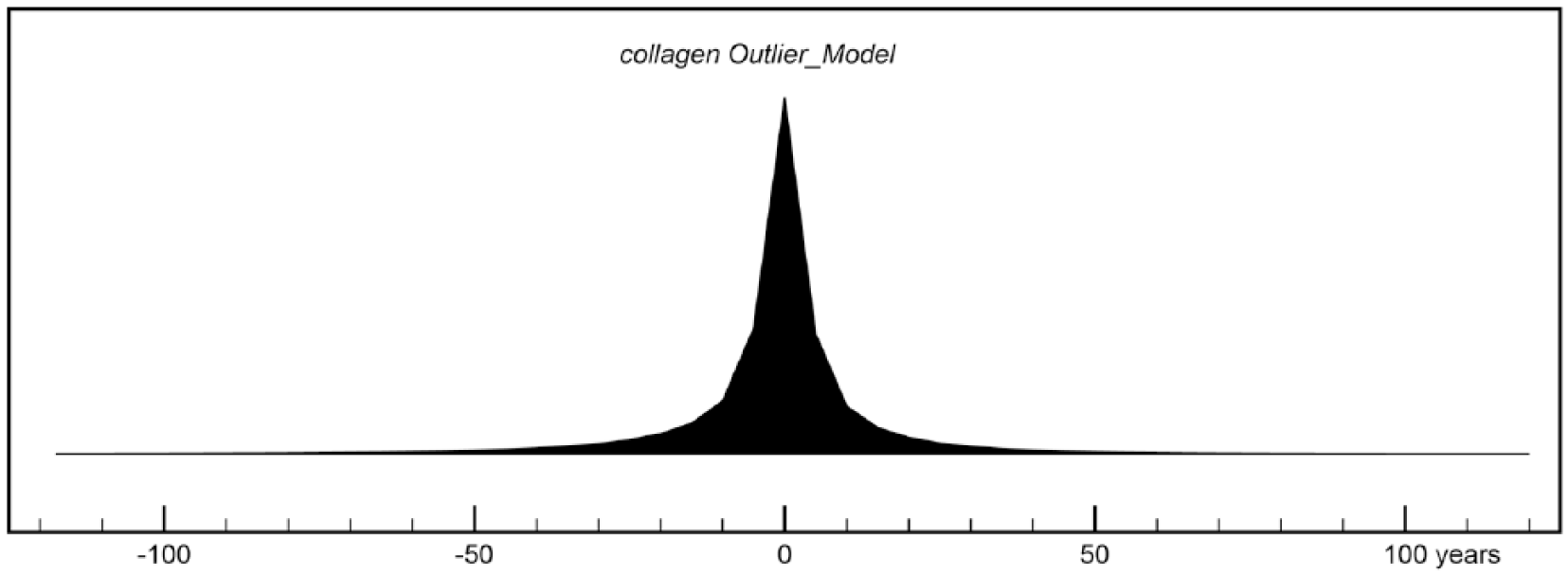
Model B, posterior distribution for the parameter collagen Outlier_Model, after manual removal of outliers (until Amodel = 60.9%). The distribution shows that only negligible 14C-age offsets (e.g. −20 to 20 years) are required for the remaining dates to fit the overall model structure.
Model A output
In Model A, the three settlements are treated as separate bounded phases, with no overall boundaries for the beginning and end of LBK activity at Vráble. Although these sequences are not entirely independent in Model A, as they use the same collagen Outlier_Model, modelling each settlement separately has little effect on output. Figure 9 shows the estimated dates of the start and end of each settlement, and the resulting life span. The overall span of LBK activity at Vráble would be almost identical to that for the south-west settlement.
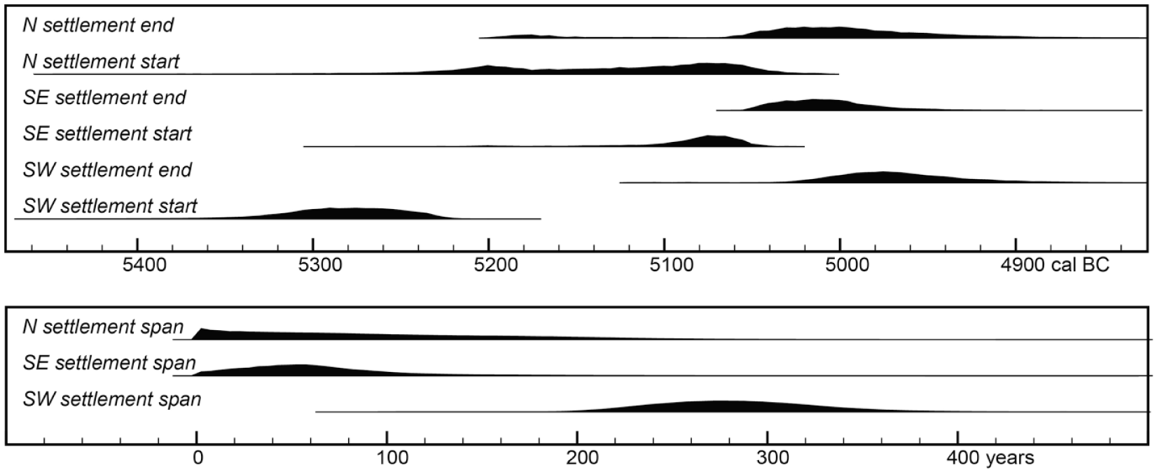
Top: posterior density estimates of the dates of the start and end (OxCal function Boundary) of LBK activity in each settlement area at Vráble, derived from Model A (Supplementary information, available online). Bottom: posterior density estimates of the life span of each settlement (OxCal function Span).
All the three areas were apparently abandoned around 5000 cal. BC, but they appear to have been founded at different times. Whereas the south-west settlement appears to have been long-lived, beginning before c.5250 cal. BC, the chronology of the north settlement (based on only nine dates from five houses) is poorly constrained, while the south-eastern settlement appears to have been short-lived. This is partly because of manual outlier removal. One of the earliest dates from the south-eastern settlement, Poz-90171 (6250 ± 40 BP), on unidentified charcoal from House 112, was omitted on the basis of a potential wood-age offset, but we were reluctant to exclude Poz-87446 (6270 ± 40 BP, 3.2% collagen) from House 132. Poz-87446 does not fit the bounded phase for the south-eastern settlement, however, and its low individual index of agreement (A = 6%) reduces Model A’s overall index of agreement below 60%, but removing Poz-87446 would produce an even shorter life span for the south-eastern settlement, and other House 132 results would then become outliers. The real problem is perhaps not with the date of Poz-87446, or the sample, but with the uniform prior of the bounded-phase model, which assumes that potential samples are evenly distributed in time between the start and end of the phase. House 132 seems to be older than not just houses 131 and 133, but perhaps all the other dated houses of the south-eastern settlement, which were concentrated in one area. With a more randomised sampling strategy, the houses dated may have been more representative of the overall occupation of the south-eastern settlement, whose estimated life span could have been longer.
Model B output
When all three settlements are placed in one bounded phase, the House 132 conundrum is resolved, as Model B allows it to have been built long before the other dated houses in the south-eastern settlement. Model B gives an acceptable index of agreement (Amodel = 60.9%) and provides estimates of when LBK activity at Vráble began and ended, which are more precise than equivalent estimates for individual settlements, being based on more data (Jakucs et al., 2016). However, the overall start date in Model B (median 5240 cal. BC, Figure 10) is later than the start of the south-west settlement in Model A (median 5280 cal. BC, Figure 9), presumably because of the dating of mainly the later houses in the south-eastern settlement. As the bounded-phase model assumes that the dated houses are evenly distributed across the entire phase, such a bias would underestimate the duration of occupation overall. Model B’s overall span (200–330 years at 95% probability, 220–290 years at 68% probability) may therefore be conservative.
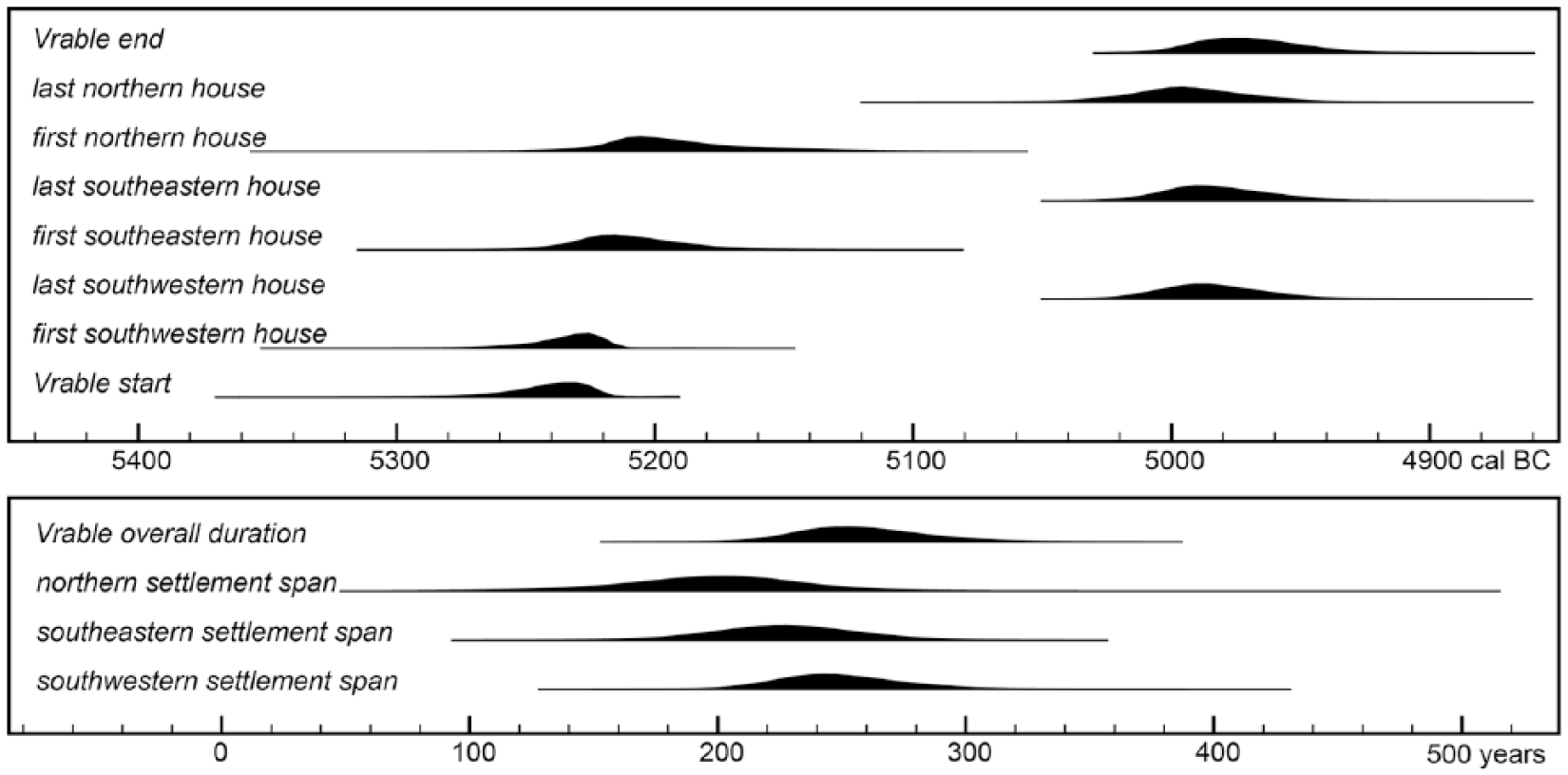
Top: Model B estimated dates of the start and end of LBK activity at Vrable, and of the first and last dated houses from each settlement area. Bottom: estimated overall duration of LBK activity and estimated life span of each settlement.
Model B estimates the dates of the first and last dated samples in each settlement (Figure 10), which suggest that all three areas coexisted for most of the LBK period at Vráble; indeed, it is possible that with a more systematic sampling approach, it would appear that the northern and south-eastern settlements began at the same time as the south-western settlement.
The question of how many houses were occupied concurrently can be investigated through two relevant parameters, the date of the oldest sample from each house with at least two reliable dates (OxCal function First) and the life span of houses with at least three reliable dates (OxCal function Span). Both the estimates are too imprecise for an unambiguous solution, even assuming that the dated houses are sufficiently representative of the great majority of undated houses. Most houses may have lasted only a few decades at most (Figure 11), but some may have lasted several generations (e.g. House 23). Overall, our results support the traditional model of short life spans for individual houses, however. If the Model B estimates are placed in a sigmoid bounded-phase model (i.e. assumed to represent a Gaussian distribution of life spans; OxCal function Sigma_Boundary), the life span of a typical house can be expressed as a probability distribution for an unknown in the same phase (OxCal function Date); the results suggest that most houses were occupied for less than 20 years.
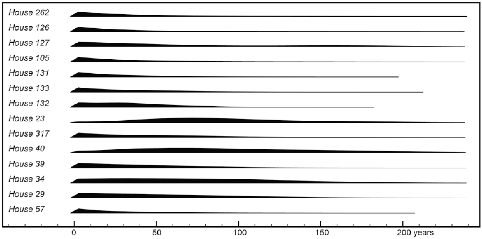
Model B estimates of the life span of houses with at least three reliable 14C dates.
Given the settlement life span, this means that the number of houses occupied at any point in time should be mainly a function of when they were built. A kernel-density estimate (OxCal function KDE_Plot) of First dates suggests only a slight increase in the rate of construction over time. While this is perhaps partly a reflection of the uniform prior underpinning the bounded-phase model, our approach avoids the misleading effects of summing calibrated probability distributions of individual dates, or of kernel-density estimation using all the 14C dates (before or after modelling), which would be biased by the larger numbers of samples dated in some of the later houses. Moreover, a KDE_Plot of the Last dates suggests a peak in house abandonment in the past few decades of settlement, which implies that the more uniform distribution for First dates is not determined by the uniform prior for bounded phases (Figure 12).
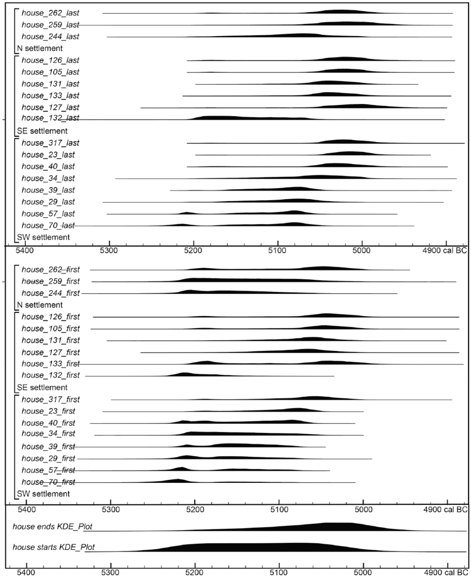
Top: Model B estimates of the date of the First and Last dated sample from each house. Bottom: kernel-density estimates of the overall temporal distribution of the First and Last dates, based on Model B estimates.
There therefore appears to be a contradiction in Model B output, between a long site chronology, short house lives and different trends for First and Last dates, which would make more sense if few houses were abandoned before the site as a whole was abandoned. This may be because five of the 14 house spans are for a cluster of later houses in the south-eastern settlement (105, 126, 127, 131, 133), which may have had relatively brief lives, if they were abandoned abruptly at the end of the LBK occupation. Omitting these houses, our sigmoid bounded-phase models indicate a median house life span of 27–28 years, close to the traditional estimate of 25 years.
Chronology of comparable sites
This study is the first systematic attempt to date an LBK settlement in Slovakia, but Whittle et al.’s (2013) simple bounded-phase model of the dates of 12 graves at the LBK cemetery at Nitra suggests that it dates from c.5300 cal. BC to probably shortly after 5200 cal. BC. The most recent graves at Nitra contain Želiezovce pottery (Pavúk, 1966), the type found at Vráble, supporting our conclusion that LBK settlements at Vráble began shortly before 5200 cal. BC.
Bayesian chronological models have been published for three LBK settlement sites in Hungary (Alsónyék, 23 LBK-era dates (Oross et al., 2016 [2013]); Szederkény-Kukorica-dűlő, 39 dates (Jakucs et al., 2016); Versend-Gilencsa, 65 dates (Jakucs et al., 2018)). When comparing these models with our Vráble models, it is important to note that each of the Hungarian sites was excavated in advance of road-building, with archaeological excavation of a proportion of the cut features visible within a 60–70 m wide transect mechanically stripped of topsoil. The overall number of houses at each site, and their spatial distribution outside of the areas excavated, are unknown, but at Versend and Szederkény the transects cut through 2–3 separate clusters of LBK longhouses, comparable to the three settlements at Vráble. The 14C samples come from the excavated houses and other cut features such as graves, rather than coring, and consist almost exclusively of articulating bones, which must be contemporaneous with the features in which they were found. However, later fills of these features were probably truncated by mechanical excavation, and the 14C results may therefore underestimate the longevity of these settlements. Collagen yields are not reported, but Oross et al. (2016 [2013]) note that a significant proportion of the Alsónyék samples were rejected on the basis of poor collagen content.
Excavation, unlike geophysical prospection and coring, can provide detailed stratigraphic relationships between dated features, where they exist. However, although the Alsónyék and Versend models include some termini ante quos from burials cutting LBK features, in general the Hungarian sites are similar to Vráble in lacking stratigraphic sequences that can be used to constrain site chronologies. Thus the published models are structurally comparable to Vráble Models A and B; the question at Versend and Szederkény was whether to treat the separate clusters of houses as chronologically independent (as in our Model A) or to treat the whole LBK occupation as a single phase (as in our Model B); both the approaches are tested in these publications, but as at Vráble, the authors favour the simpler, Model B interpretation. One of the main differences in our approach is that at Vráble, there are enough dates associated with some houses to create bounded-phase models for each house, nested within the overall settlement model. Jakucs et al. (2018) discuss house life spans, but these are only really constrained by the overall scatter of dates from Versend, rather than by chronological models for individual houses.
Despite their formal similarities, the Hungarian models gave contrasting estimates of LBK settlement life spans (Versend 10–35 years, Jakucs et al., 2018; Szederkény 120–155 years, Jakucs et al., 2016; Alsónyék 290–410 years, Oross et al., 2016 [2013]), all at 68% probability). The implications of these differences have not been explored, but logically they imply quite different populations, and consequences in terms of detecting the environmental impact of these settlements. We suspect that differences in estimated life spans may also be due in part to the overall sampling strategy employed. In contrast to the more randomised sampling of houses in the south-west settlement at Vráble, the Hungarian sites were excavated in linear transects. Depending on the internal chronology of each settlement, a transect might intersect houses spanning the full occupation of each site, or only a part of the settlement life span. Unfortunately, there are not enough dated houses at Vráble to realistically test this idea by modelling results from artificial transects through the site.
Modelling LBK land-use
There are various approaches for calculating the land-use of LBK settlements on the basis of population (overviews, e.g. in (Ebersbach and Schade, 2005: 265, Figure 7; Milo et al., 2004: 149, Figure 15)). Most authors assume a requirement of 0.5–1.0 ha arable farming area per person. According to ethnographic parallels, herds up to 0.5 cattle per person can be assumed (Ebersbach and Schade, 2004: CD-ROM 7) Ebersbach and Schade (2005) suggest that cattle needed 10 ha of grazing per animal, corresponding to an additional land requirement of 5 ha per person, but (Milo et al., 2004: 150, Figure 16) assume a forest grazing requirement for domestic animals of only about 2.5 ha per person. This results in a total demand of 3–6 ha per person in the vicinity of the settlement, in addition to the actual settlement area. Two further parameters determine the total land requirement, the number of simultaneously occupied houses and the number of persons per house. The first can be estimated by chronological modelling, but for the second we have to rely on assumptions; a small family group of on average 8.5 individuals has been assumed in recent years (Zimmermann et al., 2009: 368).
Assuming an average useful life of 25 years for LBK houses, with a relatively constant number of houses during an overall time span of c. 250 years, the c. 300 houses at Vráble imply that c. 30 houses would have been inhabited concurrently. Assuming an average of 8.5 inhabitants per house, this implies an average population of c. 250. The Vráble population would therefore have needed c. 125–250 ha of arable land and 750–1500 ha of forest grazing, in addition to the actual settlement area of 34.6 ha. The ‘footprint’ of the Vráble settlements would therefore have been between 9 and 18 km2. Given these estimates, it is not surprising that the next contemporaneous settlements are several kilometres away (Tóth et al., 2011: 312, Figure 3).
Beyond Vráble, there was a dense network of LBK settlements along the Žitava and its tributaries (Gabulová, 2015; Milo et al., 2004). These settlements also include a high double-digit number of houses (e.g. Čierne Kľačany: Cheben, 2015, 114, Figure 3). In light of these numbers, it is perhaps surprising that the LBK settlers left no easily detectable signal in the paleoenvironmental record, such as charcoals in alluvial sediment (Nowaczinski et al., 2015).
Conclusion
Bayesian chronological modelling indicates that three settlements may have coexisted throughout the LBK period at Vráble, which lasted from c. 5250 to c. 5000 cal. BC. The extended occupation of the south-western settlement is clearly demonstrated, whereas the earlier houses in the northern and south-eastern settlements may be under-represented, because of a combination of the limited areal excavations undertaken and reliance on dating low-collagen bone samples, so the three settlements may have been fully contemporaneous, even if our models would indicate that the south-western settlement began first.
Our results do not contradict the traditional view that LBK houses typically had a short life span of, for example, 20–30 years, which means that on average, given an overall occupation lasting c. 300 years, less than 10% of the 304 LBK houses recorded by geophysical prospection would have been occupied at any point in time. Although we appear to have more dates from the later stages of occupation (after 5100 cal. BC), the rate of house construction may not have changed very much over time. The rate of house abandonment appears to have been higher in the later stages, suggesting that many of the dated houses, particularly those in the south-eastern settlement, were occupied until the entire site was abandoned. Although the bounded-phase models applied at Vráble (and at the Hungarian sites) imply that we believe that Vráble was abandoned instantaneously, it is more likely that no new houses were built after a certain point in the mid–late 51st century, and that extant houses were quickly abandoned over the following decades.
Extensive geophysical surveys and prospections have also been carried out in recent years of smaller LBK settlements around Vráble. These also allow the reconstruction of settlement and population size. In a next step, it is planned to include the neighbouring settlements in reconstructions of LBK population and environmental impact in the Žitava valley. The evidence from Vráble alone suggests that there was a low and relatively constant anthropogenic impact throughout the later LBK, which may explain why it is not immediately obvious in palaeoenvironmental sequences.
Supplemental Material
supplementary_information – Supplemental material for Temporal dynamics of Linearbandkeramik houses and settlements, and their implications for detecting the environmental impact of early farming
Supplemental material, supplementary_information for Temporal dynamics of Linearbandkeramik houses and settlements, and their implications for detecting the environmental impact of early farming by John Meadows, Nils Müller-Scheeßel, Ivan Cheben, Helene Agerskov Rose and Martin Furholt in The Holocene
Footnotes
Acknowledgements
This paper is the result of collaboration between members of subprojects C2 and G1 of the CRC1266 Scales of Transformation – Human-Environmental Interaction in Prehistoric and Archaic Societies. New radiocarbon analyses at the Poznan laboratory were funded by subproject C2 (The dynamics of settlement concentration processes and land-use in early farming communities of the north-western Carpathian Basin; PIs M Furholt until mid-2018; J Müller since). Analyses by the Brussels, Groningen and Kiel laboratories were funded by subproject G1 (Timescales of change - chronology of cultural and environmental transformations; PIs J Meadows, T Meier). We thank the staff of all four laboratories for their cooperative and professional work. We gratefully acknowledge funding of CRC1266 by the Deutsche Forschungsgemeinschaft (DFG, German Research Foundation, Project 2901391021), and the helpful feedback from other colleagues in the CRC, particularly Wiebke Kirleis, Dragana Filipović and Johannes Müller. We would further very much like to thank the Institute of Archaeology of the Slovak Academy of Sciences for its continuing support. The work discussed in this article was also funded by the VEGA-Project 2/0107/17. Civilization development and settlement structure during the Linear Pottery culture era in the Lower Žitava basin.
Declaration of conflicting interests
The author(s) declared no potential conflicts of interest with respect to the research, authorship and/or publication of this article.
Funding
The author(s) received no financial support for the research, authorship and/or publication of this article.
Supplemental material
Supplemental material for this article is available online.
Notes
References
Supplementary Material
Please find the following supplemental material available below.
For Open Access articles published under a Creative Commons License, all supplemental material carries the same license as the article it is associated with.
For non-Open Access articles published, all supplemental material carries a non-exclusive license, and permission requests for re-use of supplemental material or any part of supplemental material shall be sent directly to the copyright owner as specified in the copyright notice associated with the article.