
Abstract
This paper summarizes the informal settlement upgrading processes in the Namibian municipality of Gobabis, which are arguably the most accomplished bottom-up developments in the country so far. As these processes were made possible through a broad coalition of partners, we employ the lens of co-production and engage with the more recent literature on it, which focuses on questions of equity and empowerment. We note how co-production achieves more efficient use of resources and decentralizes power in urban development. We argue that in this case, efficiency and equity are aligned. We also note how despite these achievements, the balance of power remains uneven in favour of central and local governments. The paper also briefly describes the context of urban development in Namibia, and concludes with a set of questions for further research on co-production of land for housing the urban poor.
Keywords
I. Introduction
The purpose of this paper is to expand on the relevance of co-production for access to and development of land for housing in informal settlements of Gobabis, an urban area in the east of Namibia. The processes outlined here are familiar to many, given the more than two decades of documented bottom-up efforts in urban development by the Shack Dwellers Federation of Namibia (SDFN) and its support NGO, the Namibia Housing Action Group (NHAG). This partnership has become an exemplar of bottom-up urban development in Namibia, and its work in Gobabis may well be one of the most studied cases in Namibia’s recent urban development. Associated research has included work on the potential of affordable tenure forms,(1) the use of self-enumeration data in informal settlements for the purpose of participatory settlement upgrading,(2) analyses of co-produced socio-spatial processes,(3) and outputs of local organizations detailing the processes as solutions for the urban poor.(4) This paper aims to mobilize this literature to provide a synthesis of the case, while raising new questions for further research.
Several upgrading processes have taken place in Gobabis, or are underway. Although we also refer to these processes in two other settlements, the primary location in question here is Freedom Square, one of the oldest informal settlements in Gobabis and a pilot project for the implementation of the Flexible Land Tenure (FLT) system.(5) (This system allows for the creation of alternative forms of titling, which can eventually be upgraded to freehold titles.) After briefly introducing key aspects of co-production (Section II), the Namibian urban context (Section III) and the policy framework (Section IV), we outline the processes in question (Section V), employing the lens of co-production to explore questions regarding housing and land that are raised in this particular issue of this journal. The experiences related here are analysed and discussed (Section VI), and we conclude with a set of questions emerging from this case (Section VII).
This paper draws on the direct experiences and involvement of all four authors, as well as detailed accounts from various stakeholders, gathered for the doctoral research of one author and the master’s thesis of another.(6) For the PhD thesis, semi-structured interviews were undertaken with local authority (LA) officials, Shack Dwellers Federation of Namibia (SDFN) representatives, Namibia Housing Action Group (NHAG) staff, foreign cooperation agency workers, and students; several documents were gathered and analysed to triangulate these accounts. For the master’s thesis, semi-structured interviews with stakeholders, focus group discussions, and secondary data analysis (spatial data and settlement profiles) were undertaken.
II. Recent Questions about Co-Production
Early debates on co-production, a term now broadly used in the field of urban development, emerged in the area of public administration in the 1970s and 80s, when ideas of “participation” in urban development were already considered widespread.(7) Early writing on co-production, as Mitlin notes, reinforced “Weberian divisions” with regard to “the public” and “the private”.(8) Later writings focused on partnerships for development that included the state, civil society and an array of other stakeholders.(9) The state was repositioned as one of the actors within a constellation. This has significant implications, considering the centrality of the state within the modernist paradigm, particularly well documented in former colonies.(10)
Today, discussions on co-production include various actors, and also profit from being in dialogue with contemporary debates on transdisciplinarity(11) and intersectionality.(12) In this recent literature, the virtues of co-production are challenged with fundamental questions, for instance regarding its overall purpose in processes that can easily be reduced to such utilitarian issues as land delivery. Castán Broto and Neves Alves warn that “when co-production is approached as a mere means to improve efficiency in service provision, equity questions are displaced”.(13) They furthermore question whether co-production in fact challenges oppressive urban structures.
Our paper engages with these more recent questions by examining in detail the co-productive practices in Gobabis. Another key question is the ultimate aim of co-productive practices: Is it the improvement of living conditions along lines that are acceptable to inhabitants, or is it empowerment, understood as additional benefits for parties previously lacking these?
III. Namibia: Advances and Urban Crises
Namibia is the second least densely populated country on the planet,(14) in part because large parts of the country are extremely arid. The country’s small population only recently started living primarily in urban areas. This is partly due to its relatively recent independence from South Africa, which imposed apartheid across its territory, reserving urban areas as the domain of whites while relegating the black and coloured(15) population to rural “homelands”.(16) This is the background to stark socioeconomic imbalances in the country,(17) making it the world’s most unequal country after South Africa.(18) Urban areas were segregated along racial lines and functions, an attribute that remains both unchallenged due to vested interests in property values,(19) and arguably even enhanced by urban growth along these existing structures.
Today, half of Namibia’s population lives in an urban area, mostly in informal settlements, which were virtually nonexistent on independence in 1990.(20) This figure is projected to reach 70 per cent in the coming three decades. This will mean housing an additional 2 million urban inhabitants.(21) Despite a considerable rural bias among decision-makers, urban land seems today to be at the centre of the national discourse, although this has yet to translate to policy and national budget readjustment. Only recently has “urban land” become one of the key areas of land reform, with the president describing the situation in informal settlements as a “humanitarian crisis” and vowing to declare it a “national emergency”.(22) It will be interesting to see how implementation can happen during times of austerity, given the current economic recession.(23)
At the same time, Namibia is host to remarkable urban development advances achieved through bottom-up approaches. De facto “self-help” housing existed throughout the first half of the 20th century in settlements where black people housed themselves to be able to work in urban areas.(24) While undertaken through engagement with the authorities, this was a precarious relationship. The apartheid state engaged in housing provision, but premised on influx controls. In the 1980s, with support from churches and socially committed professionals, groups of inhabitants started organizing to approach local government for access to urban land.(25)
After independence in 1990, these groups multiplied, and the support organization, NHAG, was established in 1992 to serve what became a federation of grassroots groups. An existing alliance in India established connections,(26) exchanges were organized, and the Namibian federation and NHAG joined the international organization that became known as Shack/Slum Dwellers International (SDI) – an umbrella for national affiliates from 32 countries in Africa, Asia and Latin America.(27) SDI-supported federations share a number of core practices, central to which are the savings groups that use the funds saved for housing loan deposits. Also core is the self-enumeration process, through which communities collect socioeconomic and spatial data about themselves and their settlements, which are discussed and used in the negotiation with local and national government for improvement of living conditions. This has proven in various contexts in the global South to be a vital component in creating awareness of informal settlement conditions, and in enhancing inhabitants’ social capital.(28) Another key practice is conducting learning exchanges through which member federations visit and learn from each other, within countries and internationally.
In the late 2000s, SDFN–NHAG gained support from central government to undertake self-enumeration exercises in informal settlements nationwide, which resulted in the Community Land Information Programme (CLIP)(29) (see Section Va). The Namibian federation was one of the first internationally to complete a national community-led informal settlement profile.(30) The central government provided additional support in 2000, when the then- Minister of Regional, Local Government, Housing and Rural Development (today the agency is the Ministry of Urban and Rural Development [MURD]) pledged an annual contribution to the SDFN and NHAG-managed Twahangana fund. This support has gradually increased from N$ 1 million to almost N$ 10 million annually (about US$ 682,000). During the 2010s, most housing efforts and attention were absorbed by the government-driven “mass housing” programme, and almost no land was allocated for bottom-up and other initiatives. Nevertheless, SDFN–NHAG achievements have received increasing recognition and support from private organizations nationally.
Despite recognition of the federation as a national stakeholder in various governance and policy platforms,(31) the land available to SDFN–NHAG remains limited, and the increased government funding is negligible relative to both the much-increased membership(32) and other state expenditure allocations.(33) Yet the Namibian federation is considered to be among the “mature” SDI affiliates,(34) and proportional to Namibia’s population, is the largest federation within SDI.(35) Despite the challenges, SDFN is present in nearly all urban areas and many settlements in the country, and currently has nine active projects servicing land or building houses. Based on emerging partnerships among academia, local government associations,(36) and other allies, a National Alliance for Informal Settlement Upgrading is currently in formation, with the aim of coordinating stakeholders to enhance implementation.(37) In short, despite (or, perhaps thanks to) these advances and setbacks, Namibia has reached a point where participatory bottom-up upgrading is generally regarded as viable, and the conversation now revolves around how to learn from past experiences in order to undertake a scaled-up nation-wide endeavour.
IV. An Ambivalent Policy Framework
While the policy and legal framework in Namibia remains anchored in the modernist fundamentals of apartheid’s planned separations of functions and people, there are elements that have enabled some of the processes we describe below. Shortly after independence, a Local Government Act(38) established local government in the country as we know it today, outlining its governance and procedures. At that time, the census listed 27 “urban localities”. Today there are 57 local authorities (LAs), most of them small(39) and largely dependent on central government. In 2000, a Decentralisation Act was passed, aiming to devolve central powers.(40) In practical terms, however, the central government still holds considerable power over local government matters.(41) It is important to highlight that Namibia does not have a “ward system”. Instead constituents elect a political party that in turn delegates members to the local council in question.
Also, soon after independence, Namibia formulated its National Housing Policy, which recognized bottom-up approaches, but also included such limitations as a minimum plot size of 300 square metres. The policy was revised in 2009, reflecting a more neoliberal approach repositioning housing more as an economic asset than a human right. “Affordable” housing would increasingly be regarded as a profitable sector and the government would subsequently lure the private sector into this, sometimes with subsidies not targeting the lowest-income groups.(42)
In terms of global frameworks, Namibia participated in both the Habitat II and III global conferences on housing. While the former spurred the development of local plans,(43) the latter has had little impact on national agendas and plans. Although its constitution does not confer the right to housing, Namibia is a signatory to the International Covenant on Economic, Social and Cultural Rights, which binds it to observe the right to adequate housing. However, there seems to be little awareness of what this right entails, and it has not yet been invoked or interpreted in court.(44)
One apparent opportunity that Namibia has, with regard to the provision of secure tenure, is the Flexible Land Tenure System (FLTS),(45) an affordable form of titling conceived in the mid-1990s. Legislation was only passed in 2012, and regulations finally adopted in 2018. While in principle this titling was thought of as a co-produced form of tenure, entailing the formation of associations to undertake some tasks in the process, recently published regulations involve considerable bureaucratic requirements. The process is led by the Ministry of Land Reform (MLR); and although some activities have been taking place, it is only since the regulations of the act were passed (2018) that the system could be implemented. MLR will however start piloting this only in three identified urban areas, one of them Gobabis. Results, therefore, remain to be seen.
V. What has Happened in Gobabis
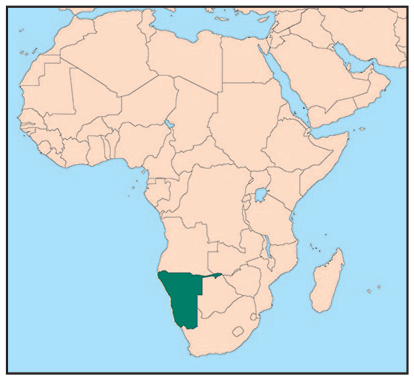
Gobabis, the regional capital of the Omaheke region east of Windhoek, has a population of 19,101.(46) The town is the main urban part of a cattle farming area, but its economic base, like that of the larger area, is otherwise limited. The town follows the typical apartheid planning structure, with a central area and wealthier southern neighbourhoods, separated by the industrial area to the north and a golf course to the east from the black and coloured neighbourhoods, respectively. The informal settlements do not appear in the latest town planning scheme. However, the local authority recognizes and reports on them,(47) as they cover a considerable portion of northeastern Gobabis (Map 1), along with the low-income (formerly black) areas (Epako).
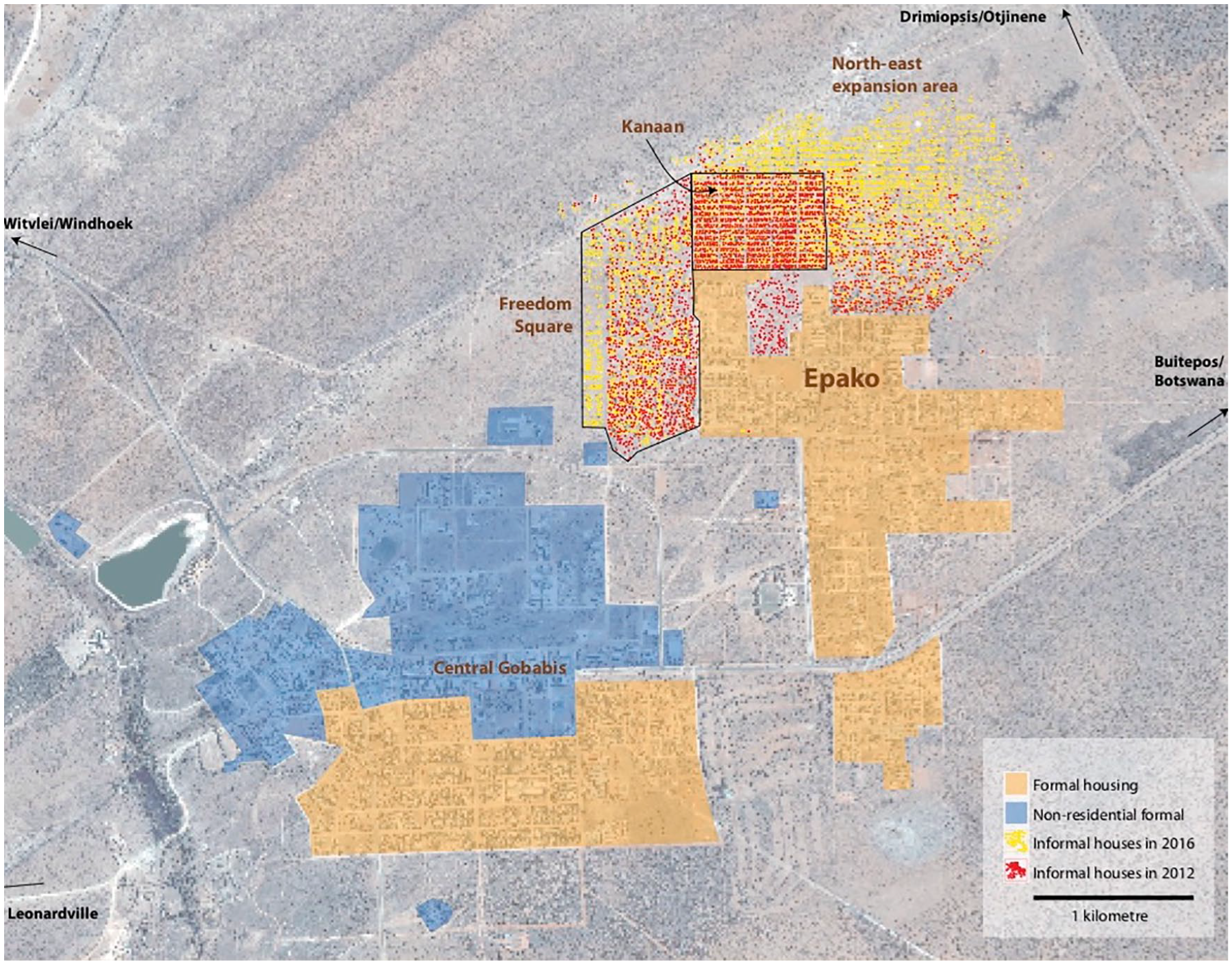
Mapping of informal settlements in Gobabis by Development Workshop Namibia
a. The Community Land Information Programme
Gobabis has seen successfully completed cases of SDFN-supported housing developments since the late 1990s. An early example was south of Epako, where a savings group upgraded its neighbourhood through a process recognized by UN-Habitat.(48) Other groups secured tenure and built houses in 2008. Information collection is a key process for SDFN, and door-to-door enumeration was undertaken by inhabitants in the early 2000s (an activity thereafter known as CLIP). The partnership mainly referred to in this paper started with community-driven mapping and data collection in 2012 as part of a city-wide CLIP initiative including all its informal settlements. During a feedback session on the results, the inhabitants of Freedom Square protested against municipal plans to relocate them to an even more peripheral area, in order to develop the land for “formal” housing. With the assistance of a Spanish NGO that supported NHAG during CLIP,(49) a learning exchange was organized to visit Cape Town and Stellenbosch in South Africa.(50)
Through the exchanges organized with Gobabis, local inhabitants, an LA official, a councillor, NHAG officials and SDFN representatives were exposed in South Africa to the process of reblocking (i.e. the repositioning of housing structures to improve spatial qualities of an informal settlement) and incremental services improvement; the virtues of self-enumeration;(51) upgrading through a partnership approach; and the value of written agreements between LAs and inhabitants.(52) Arguably, this experience changed the way Gobabis Municipality liaised with inhabitants in local informal settlements. The municipality proposed a similar reblocking approach, which led to upgrading instead of relocation, and paved the way to development of a partnership for upgrading in Freedom Square. The partnership expanded, and a wider array of stakeholders became involved. The ambition at this point had started to focus on the wider perspective of “city-wide planning”, gradually including the other informal settlements, with Freedom Square taking the lead with significant physical improvements.
b. Planning studios
The concept of “planning studios” derives from collaborations between communities and academics. The academic interest was initiated by the Association of African Planning Schools (AAPS)(53) working with SDI. During a conference they held in Tanzania in 2010, academics were inspired by studios Kenyan professionals presented, undertaken as a partnership between SDI and the University of Nairobi. A programme was thereafter developed to undertake joint AAPS–SDI studios in different countries, including Namibia, with the objective of exploring alternative planning methods based on partnerships with local inhabitants, organized through the SDI network.(54) At the same time, there were physical improvements at some of the sites, and in other cases, memoranda of understanding (MoUs) were forged between partners.
The Namibia University of Science and Technology (NUST), SDFN and NHAG implemented the planning studio in Gobabis as part of the “community-based projects” within the undergraduate programme of Town and Regional Planning. The first studio in September 2013 had site analysis as an objective. Students prepared a land-use survey and, with community representatives, examined the drainage, vegetation, physical infrastructure and access to bulk infrastructure. Inhabitants had already done an extensive CLIP exercise and made these socioeconomic data available to students.
The 60 hectares of land in Freedom Square would ordinarily have been subdivided into four “townships” for conventional servicing.(55) For the purpose of these co-production processes, the land was subdivided into eight blocks by the enumeration teams, guided by NHAG and the local authority. The blocks’ divisions were created using aerial images and guided by walking paths and the natural drainage pattern. The few permanent building structures were identified, along with trees of importance, the most prominent roads, flooding areas and other features. The process of reblocking, which entailed relocation, strongly involved inhabitants, which made the issues of compensation and reimbursement of expenses due to displacement less of a concern.(56)
The second planning studio in March 2014 made use of the tools previously employed to facilitate participatory design of layouts. Connectivity within the settlement and to other neighbourhoods was discussed and incorporated in the design. The event was attended by officials, politicians and SDFN members from other regions, as well as an SDI team from South Africa. The process of creating the spatial layout involved many Freedom Square inhabitants. This studio brought new life to the planning process and allowed for inhabitants’ needs to exert an influence on the layout. The different blocks had to present their results, and changes were made to tie the eight plans into one coherent layout plan. The initial submission for the creation of the larger piece of registered land as one block, to allow for land registration, was undertaken by a NUST town planning lecturer and approved by the local council. When the Ministry of Land Reform took over the process as part of the piloting of the FLT project in 2015, it decided to divide the informal settlement into still smaller blocks, using as a guide the proposed number of households that each association applying for FLT titles was required to have under the regulations.(57)
c. Reblocking and preparations for Flexible Land Tenure
The council-approved layout enabled inhabitants to embark on the reblocking with the support of the other stakeholders. In neighbouring South Africa, reblocking seems only a temporary exercise not necessarily leading to longer-term security of tenure;(58) but here this exercise was undertaken with the goal of long-term settlement. High-quality aerial images were captured by a land surveyor who was piloting the use of drones,(59) and the new layout was overlaid on them. This assisted the residents in identifying the structures that needed to be shifted to fit into the new plots. At some point during this process, it also became clear that Freedom Square would become a pilot for FLT. As part of this, the outside boundaries of the settlement were measured by a qualified land surveyor with support from the German Cooperation Agency (GIZ) as part of its Support to Land Reform programme in Namibia in 2015. The Global Land Tool Network (GLTN) supported the implementation of the Social Tenure Domain Model (STDM),(60) which enabled the measurement of the inner blocks by a survey technician, while the plots were measured by residents assisted by a NHAG technician and a land surveying student from NUST.
Land measurement took place in November 2015 before relocation started. First, structures had to be moved to make space for the bulk sewer line that would serve the settlement. Other structures also required shifting to clear streets, including those outside the boundaries of the settlement, which needed to be brought in and situated within a plot. In all, about two-thirds of the structures were moved to fit within the layout. Structures had to be dismantled, and in some instances the municipality assisted with transport, but in most cases inhabitants themselves transported the structures in wheelbarrows. In some cases, younger members assisted older ones. NHAG and the municipality helped guide the process, indicating where the boundary pegs were. Existing structures that were closest to designated parcels were moved there; those households that could not obtain parcels within their blocks had to move to open parcels in other blocks. Within two months, 70 per cent of the households occupied their land.(61) This process had to be completed relatively quickly to prevent people from outside the settlement from occupying open plots.
The initial eight blocks had plots for more than 100 households – a large number in relation to the usual size of SDFN-affiliated groups. While the process of reblocking strengthened ties among inhabitants, especially when it became clear that the land was not exclusively for members of SDFN saving groups, the numbers involved presented challenges for organizing. The large extent of the area necessitated continuous engagement with all the households, and not all residents were able to attend meetings or take part in the activities. NHAG and SDFN members realized the problem of operating at this scale, and to facilitate maximum participation, they organized the communities within each block into smaller clusters (up to 40 households). This was done to prepare the occupation certificates, generated as part of the STDM land recording tool. This in turn required the involvement of residents in order for them to gain an understanding of the tenure privileges and responsibilities.
However, despite considerable work undertaken to this end, the Strategic Executive for Local Economic Development at the municipality subsequently decided not to make a submission to the council for approval of the certificates, but rather to wait for the subsequent implementation of the FLT pilot. Perhaps due to a limited understanding of the role of communities in the process, and despite the flow of information among parties so far, the ministry (MLR) did not include NHAG, SDFN and the inhabitants in implementation of the Gobabis pilot. It started to focus instead on implementing regulations as a technical process involving the local authorities and town planning consultants. This affected local ownership of the process by community members, who were initially supposed to lead this process, and who as a result had less understanding of the practical implications of their formalization. From this point on, the responsibility for establishing the process of voluntary association relied primarily on MLR in collaboration with the municipality, and less so on the inhabitants.
d. Service installation
The priority need of inhabitants for the installation of sanitation and more water points had been one motivation for the reblocking of Freedom Square, and was presented by the inhabitants to the LA. The municipal engineer prepared the service plans and bill of quantities, and a partnership formed by SDFN, NHAG and the Gobabis Municipality applied to MURD for funds. The ministry made N$ 8 million (about US$ 546,000) available for materials so that inhabitants could install their own water and sewer infrastructure, with training from a plumber hired by the NGO. They were to do the excavation themselves. In the end, only a small group received the sewer installation training because the soil was found to be too rocky and the required excavations were too deep and dangerous to be done manually. A contractor with the necessary skills and equipment was identified by the municipality and contracted to provide his services at a negotiated fee for the construction of 340 manholes, a number that some engineers found too high for the intended purpose.
Inhabitants subsequently requested prepaid water meters, which allow greater control over expenditure. These had not been included in the original budget, but NHAG obtained support from SELAVIP to purchase 200 of these water meters,(62) with the intention that repayment from residents would fund the remainder. Currently, 90 per cent of the planned infrastructure has been installed, and 90 water points are now being used communally (Photo 1).
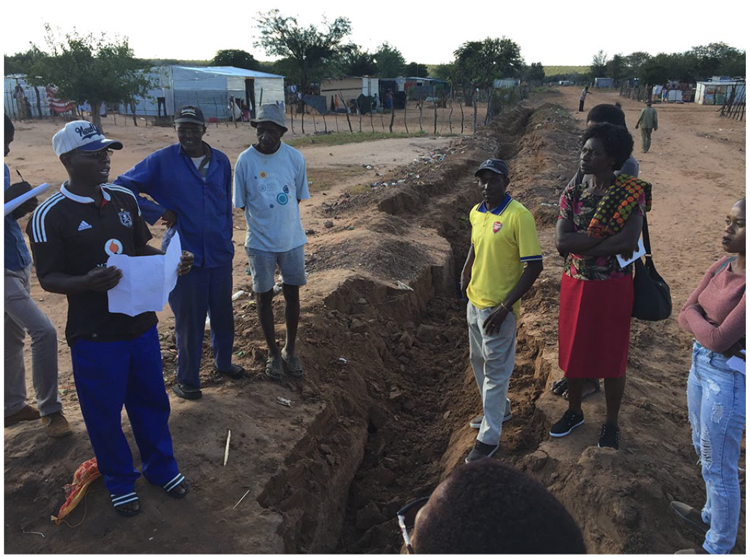
Digging of trenches for the infrastructure in Gobabis
e. Kanaan C and Tuerijandjera studios
During the process of reblocking Freedom Square, the neighbouring settlement of Kanaan C was rapidly expanding, as people anticipated that this area would also be included in this ongoing process, perceived by some as a “land allocation” exercise. Kanaan already had communal water taps and was not facing the threat of eviction that Freedom Square was, so the engagement from inhabitants in the process was less strong than in Freedom Square. There was in fact an understanding between SDFN–NHAG and the municipality that after the upgrading of Freedom Square, Kanaan C would follow, but the illegal occupation of allocated land following one of the first CLIP enumeration exercises in Kanaan C resulted in the police having to intervene. The 40 per cent increase in structures at this point might also be explained by the generally rapid growth in Gobabis, exacerbated by a drought affecting farming in the region. Farm workers in Namibia lack tenure security on the farms where they work,(63) leading many to settle in the nearest urban area. In the face of this occupation, enumerations were halted. The process stagnated and was only resumed in 2017, after a year of negotiation, to enable the studios to follow as the next step in the process.
As with the previous studios, those in Kanaan put upgrading into the wider context of Gobabis, given how upgraded settlements connect to the rest of the urban area in terms of roads, water and sanitation infrastructure, and such services as clinics and police. Different kinds of urban layouts were presented to participants, but inhabitants participating in the studios preferred conventional arrangements largely following the pattern of the Kanaan A settlement neighbouring Freedom Square, which the LA used as a relocation area in 2004 for inhabitants settled illegally elsewhere, and which follows a conventional grid layout. While the planning studios took a city-wide perspective, considering aspects beyond the settlement itself, they lacked the information to consider broader land and housing needs, since only information about lower-income groups had been collected. While the process remained limited to the northeastern areas of Gobabis, recognition of the importance of thinking beyond the settlement’s confines was an advance.
As in the planning studios in Freedom Square, inhabitants split into small groups and presented the layouts they developed to each other. These 12 layouts were thereafter combined into one by the students and presented to both the municipality and other residents to ensure that it had been done according to the priorities established in the studios (Photos 2A and 2B). Along with information gathered in the enumeration, the layout was used in a door-to-door verification process.
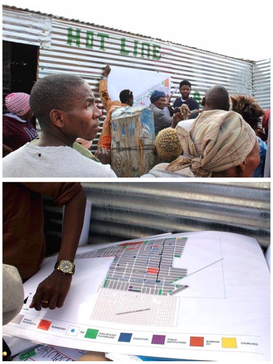
Plans for Kanaan C
This planning process was completed in Kanaan by 2018, but actual upgrading was put on hold because of the slow progress in the neighbouring Tuerijandjera informal settlement. Some of the houses in Tuerijandjera were on surveyed land that the municipality had allocated to a private developer, with the plan to relocate some inhabitants to unplanned northern areas. Inhabitants resisted this decision, and as a result, planning studios in Tuerijandjera were much slower and no verification process has taken place yet. Arguably, the non-negotiable relocation in the portions of land allocated to developers has made forming partnerships in this settlement the most challenging. The team is currently waiting for guidance from the council to re-engage with Tuerijandjera political leaders and committees in future actions.
f. Ongoing initiatives
Gobabis continues to be the site of various transformations in the settlements discussed above. In Freedom Square, for instance, a team of students from NUST and the Katutura College of the Arts approached the Gobabis Municipality with assistance from NHAG and international cooperation to develop and improve the settlement’s public open spaces. The project was participatory in its design and construction, with the municipality providing technical and logistical assistance.
The project used the methods from the planning studios for involving inhabitants and the LA. As inhabitants shared their vision for their public open space, it soon evolved to include a community centre, an informal trading area and a playground – a reflection of the need they expressed for larger social and economic interventions. With the help of inhabitants, this space was built within just a weekend (Photos 3A and 3B).
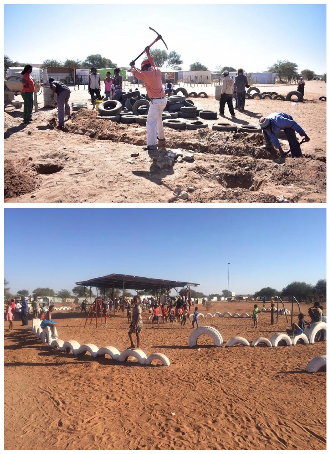
Construction (A) and finished (B) public space in Freedom Square
The processes here have gained recognition, and exchanges continue to happen, both for others to come and learn from Gobabis and vice versa. For instance, there was recently a learning exchange between Kanaan C and Karibib, a town in the Erongo region of western Namibia, where the local authority and inhabitants from one informal settlement had initiated an upgrading process based on previous exchanges. The success of prior exchanges has encouraged key stakeholders within Namibia and internationally to visit and learn from the Gobabis case.(64) This has included visits from the CEOs of eight other LAs to witness the experiences in Gobabis firsthand (Photo 4).(65) The recently appointed National Housing Advisory Committee has also organized a learning visit to Freedom Square. A booklet documenting the process describes Gobabis as a “learning centre”(66) for many today.
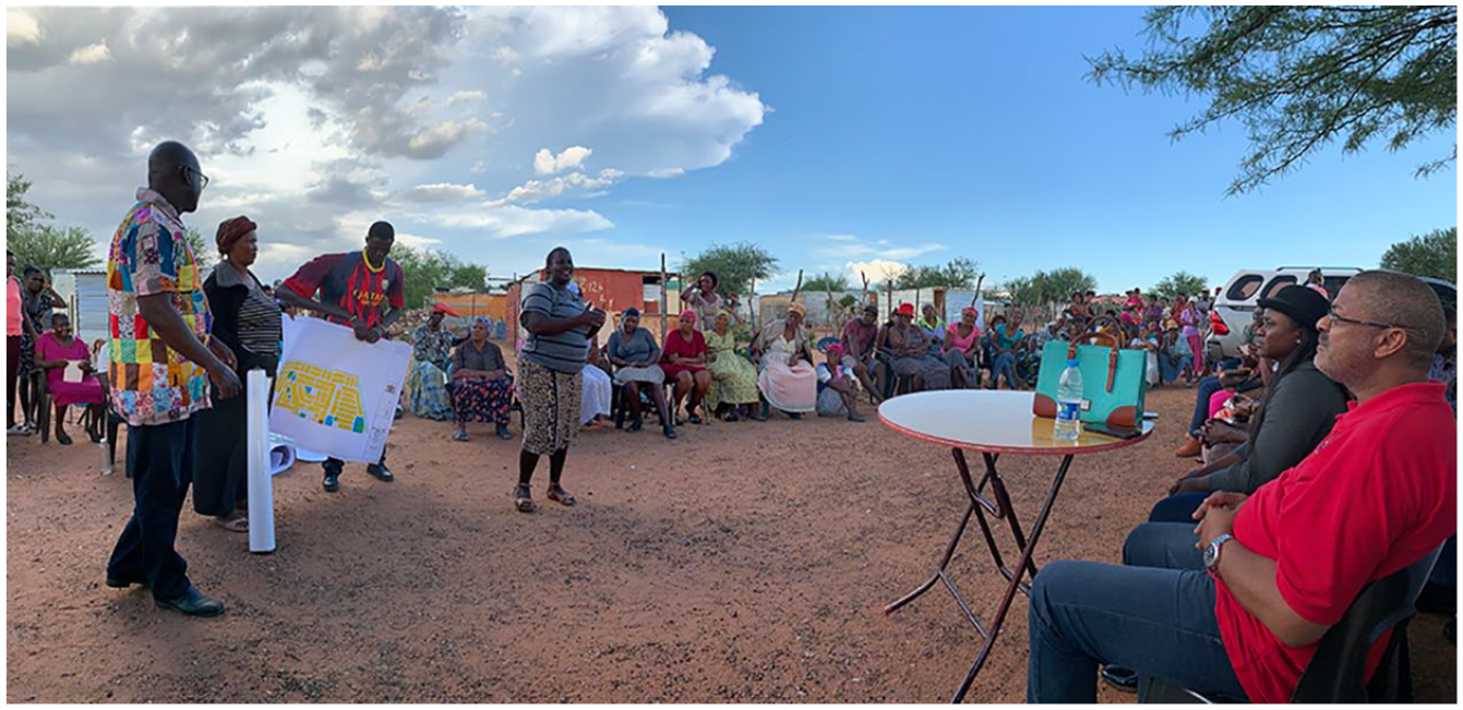
Eight CEOs from different LAs in Namibia listening to the experiences of informal settlement upgrading in Gobabis
VI. Discussion
In this section, we discuss the effectiveness of co-production in the processes described above, and in particular whether they have contributed to equity and/or challenged oppressive urban development processes and structures.
Co-production in Gobabis was in part driven by necessity, but it was also a key factor in changing attitudes towards bottom-up upgrading. The area of Freedom Square is the equivalent of almost four township developments. Servicing this area, at the average cost,(67) would have represented an investment of almost N$ 90 million (about US$ 6.1 million). The process in Freedom Square has not reached the level of full servicing, but some degree of tenure security and basic services has been attained for less than a fifth of the average cost.(68) This includes the empowerment of those who took part in the process, the technical skills they acquired, the social organizing, the engagement with authorities, and the understanding of urban development processes. This involvement on the part of inhabitants included their uncompensated contribution of labour on sewer lines, road construction, and their participation in various professional services through partnerships. Through a shared notion of partnership, the more challenging aspects of the process, such as relocation and the adequacy of compensation for loss of property, became less contentious. Residents’ cooperation around the relocation of the large majority of structures in the reblocking of Freedom Square demonstrates considerable acceptance of the process and confidence in the future upgrading of the other areas. The entire endeavour was done on a non-profit-making basis. In conventional land delivery processes, every contract entails a markup for whoever is tendering their services.
It is beyond the scope of this paper, given the lack of the readily available information, to calculate the costs in Freedom Square as compared to state expenditures for urban development,(69) but arguably we would find that the co-productive processes outlined here make far more efficient and equitable use of public funds. A reliance on regular statutory procedures for serviced land would not only have excluded those who benefitted through the current process but would actually have displaced them. Those living in Freedom Square would have needed to move to give way to the planned higher-income development. A subsidy could have bridged the gap between the cost of servicing a household’s land through these Gobabis processes (N$ 15,000 [about US$ 1,000]) and that of more formal processes (N$ 85,000 [about US$ 5,800]). But the use of the bottom-up processes described here in effect allows that subsidy to extend benefits to four other households. Here, efficiency becomes aligned with equity, as more people are reached with public funds. Through the practices described here, the impact widens.
At the same time, it must be acknowledged that the state is not in a position to consider subsidies of this kind or other larger expenditures due to the current economic slowdown. This raises the question of the kind of action that is compatible with the absence of “big budgets”. Are co-productive practices a practical solution where the state is not able to perform? Or even more critically, what should be made of a situation where a state may be in a position to afford urban development for the lowest-income groups, but does not prioritize it? Does co-production “bail out” the state from its duties or does it demonstrate alternatives? One key item to consider in the case of Freedom Square is that the initial plans were intended to displace and relocate low-income inhabitants in order to build a housing development most certainly out of their reach. The “formal” processes of land and housing delivery favoured by the state remain structurally predetermined in favour of waged higher-income earners who, while certainly in need of housing, are nevertheless vastly outnumbered by those in the ultra-low-income bracket, who are most likely to be in the informal sector or unemployed. While we argue that co-production in this case contributes to enabling elements of urban development that the government has so far not undertaken, the benefits with regard to empowerment may need to be considered as a related but ultimately separate discussion. In the case we present here, the key moment when co-production proved its power was when a shared understanding was reached that favoured upgrading for those already living there, instead of their displacement allowing for development for a more affluent group.
On the other hand, at the scale of the larger urban area, the entire process has taken place within the framework of a formal city structure that still displays the modernist and apartheid characteristics described above. The planning layout of Gobabis is a clear diagram of modernist economic, racial and functional segregation. However, in terms of process, the relationships among stakeholders have been significantly subverted. It would have been unthinkable 30 years ago to have inhabitants of the black areas presenting to the LA their information about and plans for the place where they lived. Furthermore, their achievement of upgrading rather than relocation would have been difficult to imagine during pre-independence times. The partnership approach and the new actors involved are thus significantly different from those dictated by the modernist spatial production that characterized apartheid times. The question remains whether these new processes will eventually result in a new kind of spatial reality on the ground, considering that the plans produced in the planning studios still resemble significantly the generic suburb-like planning layouts and single-use patterns that can be found in most of Namibia’s urban areas. This is in part due to the parameters set in the studios (e.g. templates for plots of land, roads, public space). The power of planning schemes in Namibia remains strong, and planning regulations have considerably influenced the spatial outcome in the studios. However, if these processes are viewed incrementally, this might change at a later stage.
The processes outlined here illustrate the participation of a broad constellation of stakeholders, and the nuances of the situation raise important questions for co-production. The partnerships in this case remain uneven. Consider the unilateral decisions taken by the local authority official who did not submit the tenure certificates to the municipal council for approval, or the decision of the ministry (MLR) not to include NHAG and SDFN in the implementation of the pilot. The latter may have had significant consequences in the subsequent rolling out of the FLT process. It also suggests that, despite the lessons learnt, inhabitants remain seen predominantly as “beneficiaries” rather than partners in implementation.
Another lesson is that associational life among inhabitants works better in smaller clusters, and that it needs to be voluntary. The relationship between clusters is important and currently not mentioned in the FLT act and regulations. This is significant; ultimately there should be widespread awareness of the process, as the illegal land occupations that risked destabilizing the process showed. Further questions also emerge regarding the constellation of stakeholders, such as: Who leads? Who initiates such partnerships? Who decides in these processes?
While the sequence of events was triggered by a concrete need on the ground, the actual process of engaging partners for the case of Freedom Square started from the request of the LA to NHAG–SDFN. From there on, the NHAG–SDFN partnership can be said to have steered this process; but it is possible to zoom in still further. One can examine in some detail who was doing what, when and how; and the account we provide in this paper allows a grasp of only some of these nuances. For instance, within the LA, it is sympathetic officials, usually with more social commitment than their colleagues, who help to adjust existing frameworks and make themselves available beyond the usual requirements of the job. In the case of NHAG and SDFN, while federation members were indeed mobilizing on the ground, it was the support NGO that effected the required action (e.g. a letter to the municipality, sourcing technical expertise). More recently, some of the latest interventions in Gobabis were youth-led. Leadership in the process outlined so far has shifted hands.
The experiences outlined here relate primarily to the upgrading of Freedom Square, west of the formal parts of Epako. By now, informal settlements have expanded considerably to the northeast, more than doubling the area of Freedom Square itself. Aspects of the process in Freedom Square are being implemented in 15 other informal settlements across Namibia.(70) However, the circumstances that led to the events in Freedom Square were unique. Therefore, rather than seeing the process as “replicable” or “transposable”, it can be described as a model or “learning centre”.(71)
It is also important to highlight that the LA itself has undertaken other interventions in the northeastern areas without the collaboration of SDFN–NHAG or the other partners mentioned here.(72) Although the upgrading in Freedom Square has unquestionably had an impact, it would be farfetched to assume we could determine the actual extent of its influence on other developments in Gobabis and in other LAs in Namibia (and, perhaps, internationally).
VII. Conclusions
The experiences in this paper reveal some attributes and limits of co-production. The modernist criterion of efficiency can, through co-productive practices, become aligned to issues of equity. Engagement through co-production can also lead to those in power, such as local government, prioritizing the needs of lower-income groups over those of higher-income ones. Furthermore, although co-productive practices can supplement low budgetary allocations from central and local governments towards urban development, benefitting the lowest-income groups, the overall goal of persuading the state to prioritize spending in this regard should not be forgotten. While the physical structures in Gobabis do not yet seem to be significantly challenged by these co-productive practices, the processes leading to these physical structures seem to have been significantly transformed.
Additional questions that are raised here for further research are whether transforming the processes behind urban development would ultimately lead to material changes in the built environment, and how it is that this has not yet emerged as a bottom-up demand. The question of “who leads” the process, appears in this case to be a less important matter than the fact that the leadership of activities in both Freedom Square and the other settlements has shifted hands. This is evidence that power has not been centralized or accumulated in one stakeholder. At the same time, SDFN–NHAG’s longer-term relationship with some LAs is a sign of trust that encourages other LAs to engage. This long-term relationship might nevertheless have come at a cost, but SDFN–NHAG has prioritized partnership over confrontation.(73) In the case of Gobabis, the relationship between the LA and the federation spans almost 20 years; and despite changes in the administration of both political and technical office-bearers, this remains arguably the most successful partnership between LAs and communities in Namibia. This is due not merely to its size, but also to its implicit potential for scaling-up processes that so far have taken place only in localized spaces within low-income areas led by a number of saving groups. The lessons about the “model” that Gobabis represents remain relevant for the national efforts in informal settlement upgrading, and arguably for international practices of co-production of land for housing through wide-ranging partnerships with strong involvement of inhabitants.
The Gobabis case points to the capacity for some degree of empowerment to take place, not only at the grassroots level but among other parties now recognized as “partners”. Although self-determination was not spelled out as an explicit demand of residents as part of the process, certainly the process supported their determination of some priorities. A key moment was when the relocation of Freedom Square inhabitants was ruled out in favour of on-site upgrading. This provided a kind of de facto security of tenure to inhabitants. However, if we consider this a gradual process of development, it seems this was a concession made to inhabitants, possibly signalling a progression to more balanced power relations. These more balanced relations imply a redistribution of power, which raises further questions: Is this trend aimed at a hypothetical balance of power between local government and inhabitants (some form of co-government)? A concern voiced by the LA was to keep inhabitants engaged during the process, as if they might eventually be “lost” through disengagement. From this point of view, co-government is not only an opportunity for bottom-up processes to gradually acquire power in co-producing the built environment with the local or central government, but also the opportunity for both levels of government to retain relevance, at least with regard to urban development.
The case of Gobabis, if understood as a co-productive practice, presents important nuances that themselves raise important questions. The Gobabis experiences raise further questions too. For example, is there a need for cohesion within the constituency in question, or is it sufficient to have pockets of cohesion representing a geographical unit and able to organize within it? Are the inherent challenges an obstacle that must be overcome, or merely characteristics of any process entailing larger groups of people? If long-term relationships between partners are important, particularly between government and organized, low-income groups of inhabitants, at what cost should they be maintained? Is the objective merely to develop quicker and cheaper plots of land, or should these processes build towards some degree of equity? Is there a need to become “equal partners”, or can asymmetries remain in order to achieve co-government? Is it possible for inhabitants to have an equal say in the finances and funding priorities of the LA in the absence of external funding for informal settlement upgrading, or should their role be limited to their settlement only?
Gobabis holds lessons in this respect, but it has the potential to yield more insights as the processes continue and evolve. While questions of “replicability” still linger, Gobabis is certainly a “learning centre”,(74) engaging us from both practical and analytical perspectives.
Footnotes
4.
5.
Enabled by a 2012 Act of the Namibian Parliament, FLT is currently being piloted in three urban areas (Gobabis, Oshakati and Windhoek). This is expected to be rolled out nationally, but the timeframe is not yet clear in publicly available documents. The pilots were selected based on the readiness of the local authority and the community. See ![]() .
.
6.
Mabakeng (2018); ![]() . The experiences of the four authors regarding this process vary in terms of time and their roles: Anna Muller leads the support NGO, has been involved in urban development in Namibia since the late 1980s, and has been instrumental in the Gobabis developments through it. Royal Mabakeng was previously part of the technical team of the support NGO, NHAG. Guillermo Delgado and Martin Namupala participated through their more recent involvement as a faculty member and a student, respectively, of the Namibia University of Science and Technology.
. The experiences of the four authors regarding this process vary in terms of time and their roles: Anna Muller leads the support NGO, has been involved in urban development in Namibia since the late 1980s, and has been instrumental in the Gobabis developments through it. Royal Mabakeng was previously part of the technical team of the support NGO, NHAG. Guillermo Delgado and Martin Namupala participated through their more recent involvement as a faculty member and a student, respectively, of the Namibia University of Science and Technology.
10.
During this period, “modern” urban development flourished under centralized, almost dictatorial environments assisted by technocrats and professionalized elites; examples of literature documenting this are Holston (1989); Avermaete et al. (2010); and ![]() .
.
13.
Castán Broto and Neves Alves (2018), page 373.
15.
Racial segregation in Namibia was practised in different ways earlier than the time that the apartheid policy was adopted in South Africa in 1948. The official classification included in the Population Registration Act 30 of 1950 defines a person as “white”, for those of the Caucasian race; “native” for “a member of any aboriginal race or tribe of Africa”; or “coloured” for those not fitting in the previous two categories; see Republic of South Africa (1950). For this paper, we use the term “black” instead of “native” to allude to the political and intellectual tradition that reappropriates the term in emancipatory ways; see ![]() .
.
17.
According to the Namibia Labour Force Survey, of the country’s 2.3 million inhabitants, only 700,000 are employed. Out of these, 75 per cent earn less than N$ 8,000 (about US$ 550) per month; furthermore, about 60 per cent of those employed are considered to be in the informal sector. Some of these numbers were obtained directly from the Namibia Statistics Agency, while others are found in ![]() .
.
20.
Recent estimates vary, ranging from those released by the NSA (which put the number of those living in informal settlements at about one-fourth of the population), to those of the Community Land Information Programme undertaken by SDFN/NHAG (which estimate that about half of the population already finds itself living in an informal settlement). See NSA (2016); and ![]() .
.
22.
24.
26.
31.
SDFN and NHAG have been recognized as national stakeholders in various ways. A few examples of recent engagements have been their recognition as delegates and presenters at the Second National Land Conference, their appointment to the task team to develop the implementation plan of the conference resolutions on urban land, and their membership of the National Housing Advisory Committee.
32.
In an SDFN document dated October 2017, the total number of members nation-wide was 23,000.
33.
For instance, in the 2016/17 National Budget, the three largest development budget expenses were railway network upgrading (N$ 390 million [about US$ 27 million]), farm land purchases for the land reform programme (N$ 327 million [about US$ 22 million]), and the “research and development” of the Ministry of Defence (N$ 306 million [about US$ 21 million]). Their budgets were 39, 33 and 31 times respectively more than the recent N$ 10 million (about US$ 682,000) allocated to the Twahangana fund. See ![]() .
.
34.
35.
SDI’s annual reports show that although most of the members are in Kenya, Zimbabwe, India, Zambia and Uganda (2014, 2015), the proportion of members vis-à-vis the country’s population (2014) puts Namibia at the top. SDFN members represent about 0.77 per cent of the population of Namibia.
36.
The Namibia Association of Local Authority Officials and the Association of Local Authorities in Namibia gather LA officials and councillors respectively.
39.
The largest urban areas in Namibia are Windhoek, with a population of about 350,000; followed by Rundu, Walvis Bay, Swakopmund and Oshakati, all with a population of 30–65,000; and 13 urban areas with a population between 10 and 30,000; while the rest have fewer than 10,000 inhabitants. The census reports on some urban areas with fewer than 1,000 inhabitants. See ![]() .
.
41.
Examples of these are appointments of LA CEOs, sales of land, tariffs, budgets, and local council matters.
42.
47.
49.
The NGO HabitAfrica later transformed into Alianza por la Solidaridad (in Spanish, “Alliance for Solidarity”). This was coordinated by the Spanish Cooperation Agency, which subsequently closed operations in Namibia.
50.
The settlements visited were Langrug in Stellenbosch, and Mshini Wam in Cape Town.
52.
53.
AAPS was supported through a grant from the Rockefeller Foundation to link up planning education institutions on the continent.
55.
56.
57.
Section 2(1) of the FLTA Regulations stipulates that a starter title or a land hold scheme “must accommodate 25 to 100 households unless circumstances make it desirable to have a different number”.
60.
61.
62.
63.
This differs from, for instance, South Africa, where legislation such as the Extended Security of Tenure Act (No 62 of 1997) enables some land rights for farm workers in the farms where they live and work.
67.
68.
N$ 15,000 (about US$ 1,000), which includes land survey costs, water and sanitation reticulation.
69.
70.
Currently, similar upgrading processes are active in 15 informal settlements in 10 other urban areas in the country: Karbib, Tsumeb, Otjinene, Henties Bay, Helao Nafidi, Outjo, Khorixas, Rundu, Mariental and Rundu.
72.
Some of these include the relocation from a plot of land within Epako slated for a “mass housing” development to an area in the north, where inhabitants were resettled in “planned layouts” for future development.