
Abstract
Over the last three decades, Windhoek, Namibia has grown substantially. In line with the general urban growth, Windhoek’s informal settlements have expanded, making it ever more pressing to secure basic services and suitable housing for residents of these settlements. This paper, drawing from the author’s PhD completed at the University of Manchester in 2013, documents how one social movement, the Shack Dwellers Federation of Namibia (SDFN), has challenged and collaborated with the City of Windhoek to improve living conditions. The analysis draws on varied data sources – including extensive interviews with government and federation representatives, the SDFN’s own data, and maps showing the spatial transformation of the city – to trace the recent history of co-production in Windhoek. The continuing marginalization of the city’s informal settlement dwellers points to a need for reimagining Windhoek’s residential development and integrating this into planning, as well as working with social movements like the SDFN to ensure that reforms are grounded in local realities and reflect the aspirations of those on the city’s northwest fringe.
Keywords
I. Introduction
Windhoek, Namibia experienced considerable urban growth in the years both before and after independence in 1990. Between 1991 and 2011, its population more than doubled, going from 147,000 to 326,000. This growth was characterized by the expansion of informal settlements with an attendant lack of services, security and employment opportunities.
This paper draws on a study investigating how the urban poor in Windhoek have negotiated the political, economic and social landscape to establish and advance their struggle for access to land, secure housing and services. In particular, the paper explores the contribution of one network, the social movement called the Shack Dwellers Federation of Namibia (SDFN), which is affiliated to the global movement SDI (formerly Shack/Slum Dwellers International). The paper investigates the interaction between the federation and the City of Windhoek. And it identifies the impact of this relationship on housing policy and programming, and on the spatial form of the city.
While social movements have positively influenced city planning and related policies in the decades following Namibia’s independence in 1990, these impacts have been mediated by the politics and power centred within the City. A process of co-production for upgrading informal settlements and developing new areas with a range of community groups was introduced by the City in 1999, with encouragement for self-help and incremental improvements.(1) However, while the City has reacted positively to the agency shown by the federation and individual organized communities, with changes in policies and processes through which the urban poor could secure land and access housing and services, reforms have been limited by the structure within which the planning decisions are made. This, in turn, has limited the overall impact of the movement.
Section II describes the methodology used in this study. Section III provides contextual information about the development of Windhoek and the challenges faced by the urban poor in the city. Section IV describes the efforts undertaken by SDFN and its support organization, the Namibian Housing Action Group, and documents the City’s shift towards a progressive policy on informal settlements. Section V analyses the impact of these reforms on the spatial form of the city. Section VI concludes.
II. Methodology
To explain the spatial transformation of the city and explore how spatial dynamics are linked to social and political processes, the research methodology drew on mapping data from 1990 to 2010, records of the city’s physical development and other relevant documentation, and interviews with policymakers and key informants. Two types of mapping materials were collected: GIS satellite images and layout plans. The GIS software ArcGIS was used to analyse the rate of growth of informal settlements in the northwestern part of the city. The three sets of images (2001, 2005 and 2010) were geo-referenced by the IT Officer for Spatial Data at the School of Environment and Development (University of Manchester). Models of settlement growth were then developed by consecutively superimposing each set of images over the others chronologically. To separate informal and formal dwellings, development characteristics derived from the images were used. A regular street pattern was assumed to denote some kind of formality, and informality was identified by an absence of such recognizable patterns. The analysis of materials used for the construction of the housing drew first on aerial photographs. Once areas were marked as either formal or informal, maps were developed with a colour-coded key denoting the two patterns over the three sets of images; field visits were then used to corroborate the accuracy of the findings and adjustments were made accordingly.
To understand other aspects of the impact of the social movements on the city, SDFN members and related key informants were interviewed to assess their experiences of engaging city authorities to secure land and housing for federation membership. Ninety semi-structured interviews were undertaken in 2009 in three informal and semi-formal settlements in Windhoek: Okahandja Park C, Havana, and People’s Square in Katutura East. These were supplemented by interviews with 15 key informants, including leading figures in the social movement, NGO leaders, and city and government planners and professionals. Multiple focus group discussions were undertaken with individual savings groups and SDFN leaders to test out assumptions and explore the findings.
To understand planning practice, extensive interviews were undertaken with four key informants able to explain planning choices in Windhoek: a retired town planner within the City; a former head of the planning department; the current head of planning; and a worker within the Community Development Division in post for seven years. Documentation analysed included electronic copies of council meeting minutes, annual reports, external and internal evaluation reports, correspondence between the City of Windhoek and the SDFN, survey reports complied by the SDFN and its support NGO (the Namibia Housing Action Group), and data from the SDFN’s enumeration and survey teams.
III. The Challenges Of Urban Poverty And Urban Development
a. Urban poverty and urban growth
Urban poverty in Namibia is characterized by limited employment opportunities and inadequate or insecure tenure, and often makeshift housing without water or sanitation. Urban poor communities often have little or no access to social protection.(2) Incomes are low; in 1995, 85 per cent of households in Windhoek’s informal areas had incomes below the primary household subsistence level (a measure of short-term subsistence income).(3) A 2010 survey carried out by the SDFN of its members in Windhoek showed their average monthly household income to be N$ 744 (US$ 99), with a median income of N$ 611 (US$ 81). Women’s income was, on average, 69 per cent that of men’s.
Prior to independence, urban areas in Namibia were by and large classified and reserved for the use and residence of people of the white racial grouping under the apartheid policies of the South West African government, South Africa’s proxy administrator of the Namibian territory from 1920 to 1990.(4) Blacks and other non-white races were only allowed to stay under a variety of permits. Namibia’s more recent urban growth is related to independence, and the associated deregulation of influx control measures. Rural dwellers were drawn to urban areas by the higher income expected in urban areas, and such “push” factors as declining prices for agricultural commodities(5) and the concentration of the majority-black population in the most unproductive regions, where soils were poor and rainfall sporadic.(6) In northern Namibia, the tsetse fly, along with the civil war in neighbouring Angola up to the mid-1990s, provided an additional impetus for migration southwards.
b. The historic responsibilities of the City of Windhoek
Local government structures are perceived by the centre to be designed principally to support orderly, controlled urban development.(7) Historically, urban development strategies and policies reflected unease about uncontrolled urbanization. Subsequent policy developments have largely been fragmented and overly concerned with urban housing and infrastructure, with little informed understanding of rural-to-urban migration, economic development, and/or the productive potential of rural and urban linkages.
While formally racial segregation is a thing of the past, larger cities in Namibia like Windhoek, the capital, and Walvis Bay remain divided, racially and economically.(8) The most important objective of the nationalist movements in Southern Africa was eliminating all forms of racial segregation. The new Namibian government also had highly ambitious targets for land reform and redistribution.(9) However, the focus was, and remains, on the skewed distribution of agricultural land despite the growing numbers of landless urban poor.
In Windhoek, the rich, the poor, the upwardly mobile, new migrants, and particular social and/or ethnic groups all inhabit distinct spatial zones. Most cities develop a spatial structure reflecting their society, with income, kinship, political affiliation, and religion playing a large part in determining their shape and form.(10) Where planning has been based deliberately on racial segregation, a particular urban form is created.
Windhoek in the 1950s was a more compact city, and while they were segregated, black and white people lived in relative proximity. In 1960, mass evictions and relocation of black people from the areas of Main Location, Klein Windhoek and Owambo Man’s Hostel to the black township of Katutura, some five to six kilometres from the city centre,(11) resulted in the creation of, to all intents and purposes, a separate but dependent town. Katutura was administered separately from the rest of the city, with its own town board that included non-white members.(12) With increased migration into Windhoek from the late 1980s, formal and informal residential developments further northwest of Katutura continued to be viewed as extensions of Katutura.(13) Worsening conditions in the hostels that provided accommodation for single black workers had, by the late 1980s, resulted in the development of backyard shacks in the vicinity. To avoid detection and reprisals from the City, families with formal housing constructed makeshift “chicken coops” or converted disused cars into rental accommodation or extra family living space. Overcrowding was an issue and communal sanitation facilities became so grossly overstretched that the municipality felt obliged to evict households, forcing them to find alternative accommodation. Some families found rental accommodation or space to build on farms surrounding Windhoek, where building regulations were not enforced.
Following independence in 1990, a formal land-use zoning system continued, separating land uses on the basis of a pre-determined functional logic. The “historic” Namibian city has a distinct pattern: a business district at the centre, followed by an industrial belt and a green belt in one direction; and in the other, areas of high-income housing for white people, another green belt and then low-income housing for black people. The exception to this rule was housing constructed in the colonial period for skilled white workers adjacent to the industrial belt.(14) While state-sanctioned segregation was eliminated at independence, urban planning processes continued to separate high- and low-income neighbourhoods, and the Windhoek of 2011, when this research was conducted, was still to a large extent racially and economically divided.
c. The urban housing backlog and self-help efforts
Within Namibia, the emergence of self-help housing groups began in the late 1980s, as increasing numbers of low-income urban dwellers found themselves with neither accommodation nor state support.(15) As the capital, Windhoek had borne the brunt of the huge pre-independence influx of people. At the height of the major influx between 1987 and 1992, the City estimated that up to 600 new residents were settling into Windhoek per day, 58 per cent of them in the northern and northwestern suburbs extending outwards from Katutura.(16)
The problems associated with informal and overcrowded homes, makeshift backyard shacks and communal hostels led to collective action by residents to improve their situation. The Council of Churches in Namibia took an interest and in 1987, as part of its initiatives to commemorate the UN International Year of the Homeless, convened a meeting of the homeless. This resulted in the creation of a solidarity group of men and women living in Katutura’s single quarters and backyard shacks. The emphasis was on self-help and the goal was to improve housing conditions. The process resonated with many domestic workers, women bearing the brunt of inadequate housing in the city. This initial meeting led to support from Oxfam UK and a revolving fund was created, linked to an established credit union scheme. Saamstaan (Standing Together) emerged in the centre of Katutura as a group of self-managed urban poor communities. Three savings groups were formed – People’s Square, United People and People Force – and operated a credit union with individual monthly savings. Using these collective savings and social capital, the groups began negotiating with the City of Windhoek for land on which to build housing. The Saamstaan process was happening at a time when South Africa’s political hold on Namibia was beginning to wane and there were clear signs of impending independence. The authorities were therefore accommodating and by 1991 the Saamstaan groups had built 18 houses through a self-help process.
Interest in the Saamstaan methods spread among Windhoek’s urban poor, as well as to disadvantaged families in other towns and cities. New housing groups became active and, in 1992, these groups came together and established a voluntary association, the Namibia Housing Action Group (NHAG). The NHAG’s main objective was to bring together the urban landless and homeless across Namibia, building a movement that would use collective self-help methods to address their shelter and tenure needs, while also lobbying for better policies to address the needs of the urban poor. The organization NHAG Support Services, led by a group of architects and social workers who had volunteered with the first Saamstaan groups, was established to provide technical support to these initiatives and to offer training in areas such as bookkeeping, leadership, and group mobilization and management. By 1996, the NHAG-associated savings groups had increased to 33. However, their outreach was relatively small, with only 800 families saving intermittently in often very weak savings groups. Meanwhile, an estimated 40,000–60,000 families lived in informal settlements across Namibia. To expand activities, these groups set up and capitalized a revolving loan fund, the Twahangana Fund, through which savings groups could access collective loans for housing as well as employment and income generation. During this period the fund actively sought to access government funds for housing, which were administered by the Ministry of Local Government and Housing under their Build Together Scheme.
Due to slow progress, and following reflection and an external evaluation, the NHAG was restructured into two organizations, an NGO and a people’s movement. The 33 savings groups re-launched themselves as the Shack Dwellers Federation of Namibia, a new grassroots movement that sought to attract the ordinary informal settlement dweller. Members of the saving schemes began to clearly identify with their own people’s movement and their activities started to grow exponentially. The support NGO retained the name Namibia Housing Action Group.
This process of reflection and restructuring within the Namibian alliance was happening at a time when the international network of slum dwellers, Shack/Slum Dwellers International (SDI), was also beginning to take shape. Links across urban poor movements in Asia and Africa were being developed with regular exchange visits of slum dwellers from mainly South Africa and India, and the occasional inclusion of nascent groups in Zimbabwe and Namibia. This provided an impetus as well as a wider array of experiences for the emerging SDFN to learn from, as well as share its own experiences.
This newfound regional and international solidarity through links with SDI(17) increased the confidence of the SDFN’s emerging grassroots leadership and provided it with enhanced support. This, in turn, resulted in dialogues with local and national governments for land allocation, as well as better and more enabling policies on housing. Through documentation and exchanges, the federation and the NHAG sought both to provide evidence of federation member needs and to demonstrate the self-help solutions being implemented by their sister federation in South Africa, establishing their claims on support from the government. For example, a survey undertaken in Windhoek’s informal settlements in 2000 found that the average length of time current residents had spent in the city was 12.4 years.(18)
In 2002 the Ministry of Regional and Local Government and Housing announced an annual fiscal allocation of N$ 1 million (US$ 100,000) to the SDFN movement, which would match the movement’s own savings and would be channelled to its revolving fund, Twahangana. The ministry also created a joint working group on habitat issues, in which the SDFN was asked to participate. And the SDFN began to work with the city on developing a new approach to informal settlement upgrading that underpinned the city’s Development and Upgrading Strategy.
By 2008, the SDFN movement was active in all of Namibia’s 13 regions. By 2011, 5,000 families had secured tenure and 2,500 houses had been constructed; total savings were over N$ 10 million (US$ 1.32 million). Nearly 18,000 families were members of the SDFN (at least 30 per cent of the estimated informal settlement dwellers in the country).(19) More significantly, the SDFN process and methodology had been widely accepted by both the central and local governments as a method though which the tenure, services and housing needs of the urban poor could be addressed.
IV. The City’s Response To Housing Needs
By 1995, an estimated one-third of Windhoek’s population of 182,000 lived in informal settlements in the northwest of the city. As a result the City’s planning department was under pressure to respond to and manage what at that time was perceived as a potential “time bomb”, in terms of the associated illegality and unsanitary conditions. Between 1991 and 1994, the planning department put together an interim “Squatter Policy”,(20) which sought to manage informality by directing new settlers to designated reception areas (Big Bend, Babylon and Kilimanjaro) established in 1992. Hence the ability of the Saamstaan groups to secure land reflected this relatively supportive attitude of the authorities. In addition to the provision of land for self-help groups, the municipality expanded the reception areas (with communal water points and sanitation blocks that migrants to Windhoek could use on their arrival). An estimated 4,000 plots were provided between 1992 and 1999.(21) New immigrants to the city and other long-term city dwellers seeking to escape the restrictions of the Katutura backyards or employer accommodation were allowed to build their own kambashus (corrugated iron shacks) in these areas. However, the rate at which the City could deliver land could not keep up with the number of new residents moving into these areas. The result was the formation of several informal settlement areas in and around open plots of land (including those reserved for schools and clinics), and increased densities in the established reception areas.
The City appeared to believe that families would increase their incomes and move out of the reception areas to fully serviced plots, although this did not happen.(22) At that time, the municipal policy was to maintain housing and service quality, and resist a decline in standards.(23)
In the new reception and informal settlements in the northwest of the city, people built mainly with corrugated iron sheets. Houses ranged in size from a single room of about 8 square metres to residences as large as 90 square metres. Most settlements had access to a communal water point within a walking distance of up to a kilometre from each home. Even though the city’s standards, as established in the Squatter Policy, called for a water point within 200 metres of each plot, this was only possible in the settlements that had been laid out before people moved in. A community leadership structure emerged in some settlements, drawing on the political structures of the political party SWAPO, in which households are organized into cells at the settlement level. A collection of cells makes a section and a number of sections make a branch. Across settlements, branches are then organized into a district, each level with its own leadership. At the settlement level, this leadership helped in laying out plots, to ensure that access was provided for ambulances and other emergency services. Where facilities pre-dated the settlement and the settlement had already been planned, households were organized around the water points and communal sanitation facilities. In the reception areas the layout of the shacks followed a grid pattern, with each household/unit having access to between 100 and 200 square metres of land. Most of the shacks had road frontage. By the year 2000, there were 33 recognized settlements, including both reception settlements the city had developed and those that had developed spontaneously.
The Squatter Policy, which decriminalized squatting, operated from 1990 to 1998. The City originally assumed that once migrants had settled, they would leave the reception areas and find more permanent housing. Between 1992 and 1999, the city developed 800 low-income erven (surveyed plots with titles) with full services in Otjomuise and nearly 3,000 low-income plots in Goreangab. However, following independence in 1990, it became apparent to City planners that the assumption that this level of servicing would be affordable to people in reception areas was flawed. Instead the reception areas became permanent homes. The number of informal settlement dwellers also continued to grow, and by 1999 every piece of open land in the Okuryangava Extension and Goreangab Extension had been occupied informally. It was also recognized that employment opportunities in both the formal and informal sectors would not expand at the level required to ensure full employment for all these people.(24)
Enthusiasm for reforms within the City of Windhoek culminated in the production of guidelines for informal settlement upgrading that both enabled informality through reception areas and extended the concept, taking into account the kinds of emerging self-help strategies used by the SDFN-affiliated groups. A small group of the City’s planners felt they could not continue to ignore overcrowding in the hostels, nor could the City continue its intolerance of informal housing. Officials also recognized that the City could not provide land and housing conforming to desired standards, given the rate at which people were migrating to the city. There was a consensus, therefore, to plan for the existing overcrowding as well as expected influx. City officials attribute these changes to policy debates emerging out of UN-Habitat, as in the period before and after independence, UN-Habitat played a critical role in shaping Namibia’s human settlements policy.
Some specific successes could be demonstrated to the City. People’s Square, for instance, was a group in Windhoek, mainly of women domestic workers who joined forces in 1989, and who pioneered the SDFN’s methodology. In 1991, they bought the first urban communal plot in Namibia and continued their upgrading until 1997, taking loans of N$ 12,000 (US$ 2,400), sufficient to finance the construction of 32.9-square metre houses with water and sanitation but not electricity. Families would install electricity at a later stage. The group received national recognition with the first Best Practice award from the National Habitat Committee of Namibia in 1999. During the period of consultation on the City’s Policy, a group of municipal councillors and staff also accompanied the federation to visit developments by the South African Homeless People’s Federation in Port Elizabeth and Durban in South Africa, to learn about savings scheme activities there and the extent of self-help processes to develop low-income settlements.
From 1997, the City began to look at an alternative policy to address inward migration and the resultant growth of informal settlements, providing a basis through which the new settlements could be upgraded in a way that did not place the burden of the cost on the City. Prior to 1999, the City did not have a policy document determining the manner in which the informal settlements would be managed. The Squatter Policy did not address issues of tenure security or even permanency. However, it had resulted in the decriminalization of squatting and became a preamble to the more progressive Informal Settlement Upgrading Policy of 1999. The Squatter Policy has made it apparent that if the City were to address the housing challenges as well as living conditions of the lowest-income citizens, it had to recognize that residents in this income category could not afford the full level of services provided for under the City’s existing by-laws.
The savings groups that would later form the SDFN began to advocate for community-management approaches in Windhoek in 1993. The experience of working with SDFN-affiliated groups had provided the City with a template through which communities could organize and facilitate their own residential development. Around 1997–98, when the City consulted on a new informal settlement upgrading policy, the SDFN and the NHAG put forward a development model based around self-help and a new partnership between the poor and the municipality.
The Development and Upgrading Strategy was approved by the City in 1999 and become operational the following year. The strategy dealt with the challenge of land delivery and services provision by introducing seven development levels, ranging from 0 (no planned plot layout and services) to 6 (planned plots with full services provided) (Table 1). Differentiated service levels made it possible for the City to provide serviced land at more affordable prices to low-income residents.
Development options in the City of Windhoek
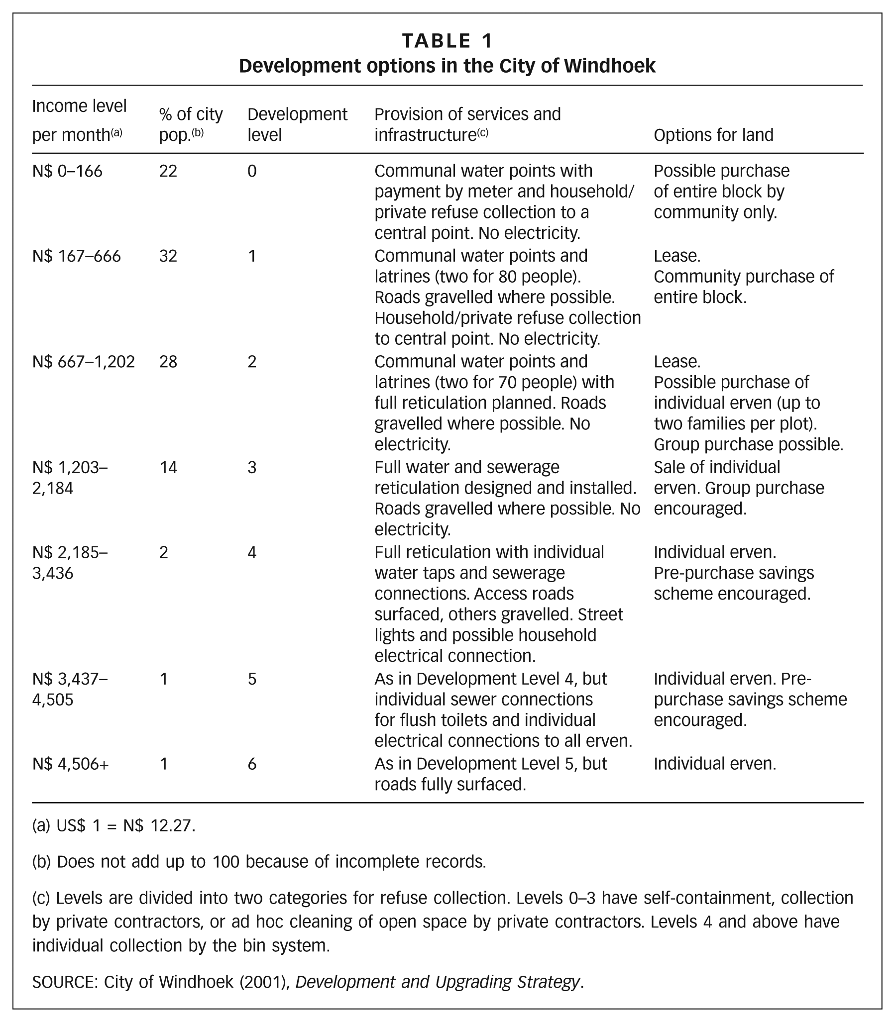
US$ 1 = N$ 12.27.
Does not add up to 100 because of incomplete records.
Levels are divided into two categories for refuse collection. Levels 0–3 have self-containment, collection by private contractors, or ad hoc cleaning of open space by private contractors. Levels 4 and above have individual collection by the bin system.
SOURCE: City of Windhoek (2001), Development and Upgrading Strategy.
Once the City had decided where the people would be settled, it initiated a capital investment programme to open up new greenfield areas as well as to upgrade the capacity of water and sanitation in anticipation for the rollout of the proposals for the upgrading strategy. Up until 2000, the plan was to develop settlements along the Khomas Hochland Mountains, as this location enabled the City to use gravity for water and wastewater management. However, the expansion of this part of the city went beyond what had been anticipated. In 2001 (at the beginning of the rollout of the strategy), the City estimated that almost 30 per cent of its population (at least 8,000 households) lived in informal, unplanned communities, in substandard structures on unsurveyed land without legal titles. However, the 2001 census reported that informal dwellings in Windhoek sheltered 13,541 households, with a total of 48,183 people. Although most households in the informal areas had access to safe water, communal taps could be at a considerable walking distance and fewer than 20 per cent of households were connected to a waterborne sewerage network.
The strategy sought to establish development options for the city’s low- and ultra-low-income households.(25) In 1999, the City estimated that 54 per cent of the city’s population could only afford Development Level 0. The highest level of tenure for this income level is a lease option with a possible purchase of land through collective means as the land could only be sold as an entire block. Under the terms of the strategy, until a community organized, there was no obligation to upgrade its neighbourhood. However, the strategy did provide a mechanism through which the newcomers, once settled, could upgrade their houses and settlement to an acceptable standard. The expectation was that they would begin with minimum services such as a communal tap and toilets, and advance to the higher level of services such as waterborne sewerage systems, piped water and a road network. It was anticipated that this process would take a number of years depending on the capacity and financial resources of the groups. The operational principles of the strategy validated self-help approaches and there were guidelines within which self-help development would be promoted and facilitated by the City. A unit within the Sustainable Development Department encouraged and facilitated the formation of self-help groups that would then enter into a social compact with the City to either lease or purchase land.
Since the inception of the Development and Upgrading Strategy in 2000, the City has followed two approaches to deliver land and provide services. The first is the physical upgrading of existing qualifying informal settlement areas and the second is greenfield development. Informal settlements qualify for upgrading on the basis of a feasibility study carried out by the City; this assesses the ease with which services can be brought to the respective areas, the associated cost, and the capacity of residents to organize self-help, including paying for upfront costs. This process is triggered when households approach the City for regularization of their occupation of the land. Formalization then occurs either through the City taking the initiative to set out blocks that people upgrade over a period of time or through a collective process by which families would come together and approach the City. This latter process, where households within a given neighbourhood form a group that enters into a land purchase agreement with the City, was popularized by groups affiliated to the SDFN and became part of the Development and Upgrading Strategy from the beginning. Groups, which may range from 10 to 200 households, organize themselves according to a block layout designed by City officials and commit to incrementally develop housing and infrastructure within the block. This process is partly financed by the Build Together housing programme of the Ministry of Regional and Local Government and Housing. Groups enter into a land purchase agreement with the City and then apply for a housing loan with favourable terms and conditions from the Ministry of Regional and Local Government and Housing. This process has resulted in opportunities to purchase land that had been informally settled, transforming it into formal townships. It demonstrates a process whereby groups can co-produce urban development, with the state providing some of the funding required through loans, and with residents deciding how they want to improve their neighbourhoods. They can either undertake the work themselves or hire contractors; whichever option they choose, they are responsible for managing the process.
Greenfield developments are supported by the City. Staff identify and plan suitable areas that are provided with minimal services based on World Health Organization standards: communal water points at a radius of about 200 metres from each household, sub-graded access roads to enable emergency services to reach the area without necessarily providing road access for each family, and communal waterless toilets at a standard of four families per toilet unit. Sanitation may be connected to sewers, depending on the proximity of the network.
a. The realization of the strategy and related challenges and opportunities
As the policy rolled out, SDFN groups were able to negotiate for more flexible terms of payment on the land purchase. While the City formally maintained its full cost recovery policy, the SDFN negotiated land loans as well as reduced interest charges. The City, as early as 1998, had sought to encourage development by making it easy to purchase land: all land purchases in the city were made on the basis of a 5 per cent deposit, with the balance payable over five years at an annual interest rate of 15 per cent. Between 2001 and 2010, continued negotiation by SDFN groups resulted in further concessions negotiated on a group-by-group basis. In general, SDFN groups could count on being able to pay for land over a period of up to 10 years, with the initial deposit payments of less than the 5 per cent stipulated by the City. SDFN members who defaulted due to difficulties in covering all the various costs associated with development, including water and land repayments, were able to negotiate with the City’s Treasury department. SDFN records in 2009 show that two groups had failed to meet their monthly land payments, with four more groups in arrears for service charges. While the City threatened to repossess the land, in all these cases a settlement was reached after the intervention of the SDFN’s national and regional leadership as well as NHAG. Terms of payment were renegotiated, and the groups were allowed to pay over a longer period.
Interviewed in 2010 and 2011, City officials appeared realistic about problems of affordability and the difficulties that low-income households had in paying for upgrading, as well as land and service charges. In this context, and without access to a direct subsidy for infrastructure installation, the City struggled to extend services. The Development and Upgrading Strategy was conceived as a self-sustaining, full cost recovery programme. It was anticipated that the expected rollout would be financed by residents’ payments for infrastructure and services. However, the research findings are that the City’s planning department officials acknowledge the need to revisit these assumptions and base the strategy on the lessons learnt about people’s capacity and willingness to pay. They believe they should make a stronger case to central government for financial support to help fund informal settlement upgrading; but this has not been forthcoming. However, despite this perspective, the City has failed to subsequently address the tenure needs of low-income groups that struggle to secure access to land and services.
V. Spatial Changes In The City
Both the spontaneous settlements and the City’s greenfield developments were set up to follow the City of Windhoek’s long-term plans as detailed in the 1996 Structure Plan. Cities use structure plans as a planning tool to manage development in an integrated and holistic manner. The 1996 Structure Plan reflected the decision of the Windhoek City Council to expand the city’s low-income settlements in a north-westerly direction, following a well-established linear model.(26) This would result in the spreading of employment opportunities over a greater area (i.e. alongside the corridor), making it easier to connect city residents while ensuring higher residential densities within the linear corridor spine. The Structure Plan proposed extending a corridor northwards within the Windhoek–Okahandja main transport node.
The Development and Upgrading Strategy consolidated these proposals by providing a framework within which informal settlements that had formed in the basin, extending in a north- westerly direction, would be upgraded. The City saw these developments as extensions of Katutura, rather than freestanding neighbourhoods. Hence the Development and Upgrading Strategy was conceived both as a spatial plan aimed at shaping the northwestern part of the city and as a process to enable informal settlement dwellers to contribute to the upgrading of their own settlements.
Windhoek’s outer edge at independence in 1990 was limited to the edges of Katutura. Over the following two decades, the northwestern boundary changed both formally, as new township developments were proclaimed, and de facto, as informal settlements continued to expand in that direction. Townships like Wanaheda, Hakahana, Goreangab and Okuryangava (Map S1 in the online supplement) were developed in the aftermath of the post-independence influx into Windhoek. A contributing factor was the decongestion of parts of Katutura such as the hostels. From 1990 to 2002 there was an increase in residential space of about four times the size of Katutura, with commensurate change in Windhoek’s population.
Map S1 shows the settlement plan for the northwest of the city and proposed development levels, as conceived in the Development and Upgrading Strategy. Each settlement within the plan is matched to the development level envisaged in the Development and Upgrading Strategy, and assigned based on the average incomes of the community in that settlement. The blue areas were earmarked for Development Level 0 (Table 1), for which the service level was communal water points with no sanitation, and the possibility of purchasing a block for upgrading. At Development Level 0, residents were not expected to pay anything. The green areas are at Level 1: access to communal water and sanitation, with a lease agreement with the City and the possibility of communal purchase of a block. The pink area denotes Development Level 2 while red areas are designated for Development Levels 3. Development Levels 2 and 3, which provided for the allocation of block erven, were sold to groups with individual or communal services.
To communicate the implications of the policy for Windhoek’s spatial development, three maps were developed examining changing land use in the northwestern quadrant between 2001 and 2010 (Maps 1–3).
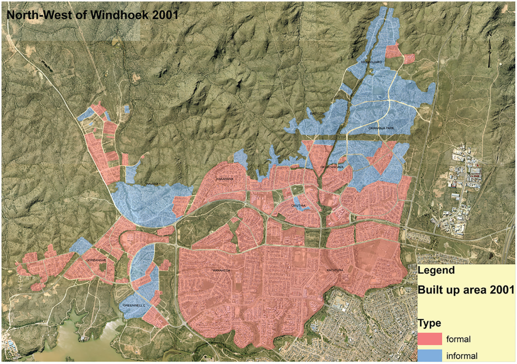
Northwest of Windhoek, 2001
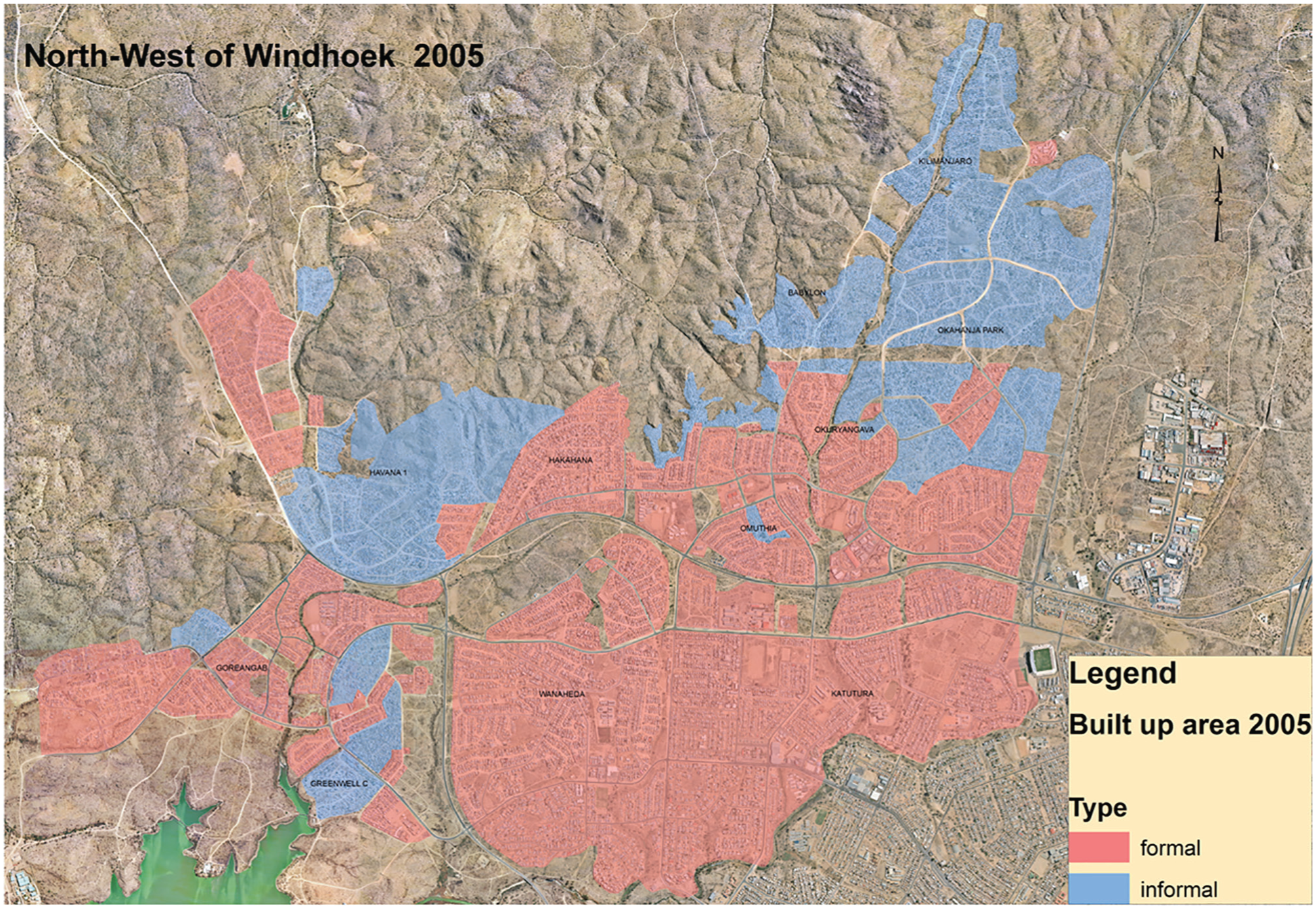
Northwest of Windhoek, 2005
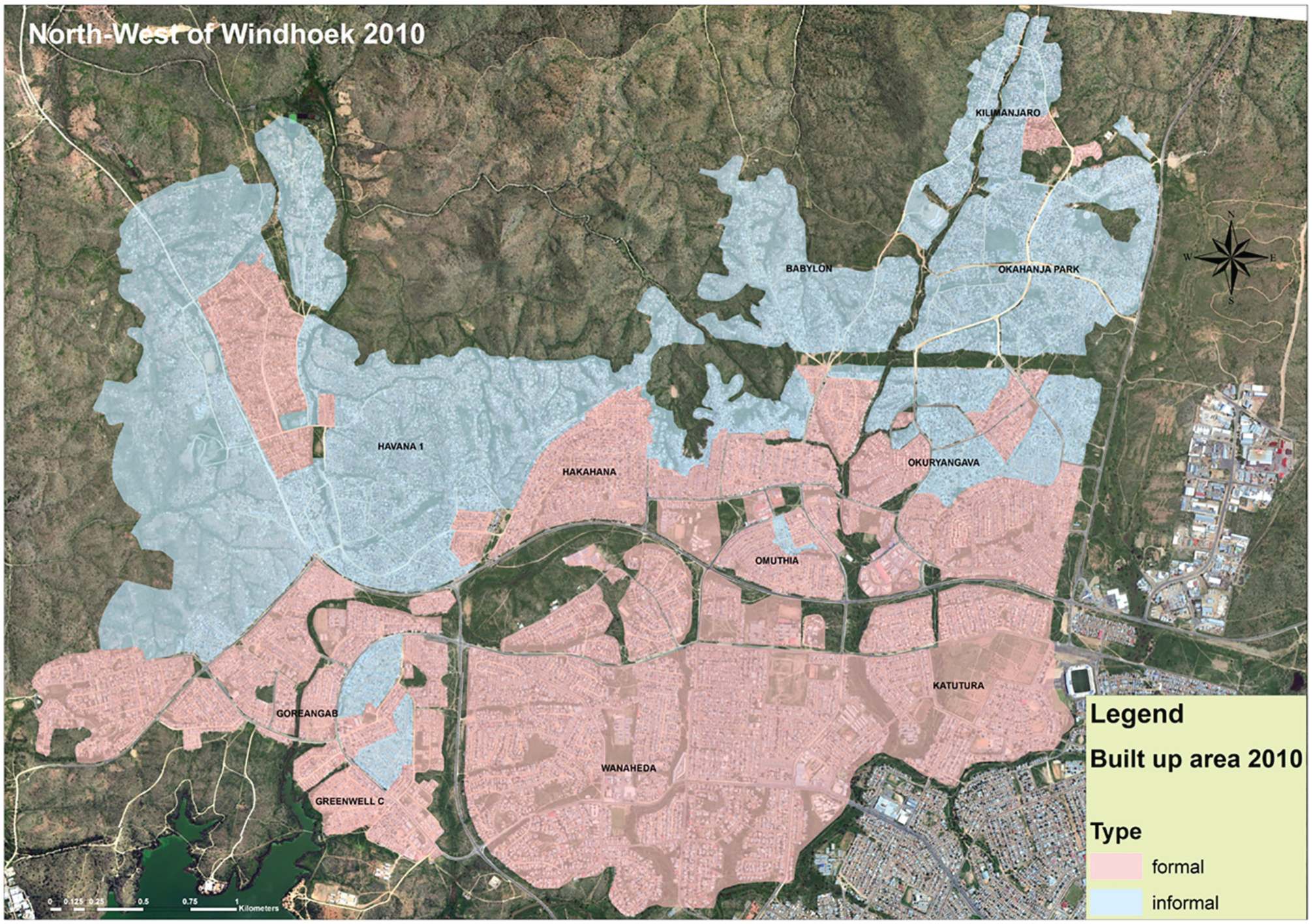
Northwest of Windhoek, 2010
The maps show the growth of settlements. The pink areas are formal and improved (Development Levels 1 and above). The blue areas are unimproved (Level 0) and include reception areas developed by the City and those spontaneously developed by citizens that had not been removed by the City (although their permanency is not guaranteed). The formal improved settlements (Level 1 and above) are concentrated to the south of the quadrant. Significant progress with upgrading and formalization would have shown a progression of this formal area northwards.
An analysis of the spatial change shows a 135 per cent increase in terms of land covered by Level 0 residential areas from 2001 to 2010 (2,974,799 square metres in 2001 and 7,003,003 square metres by 2010). In comparison, the area covered by improved settlements (Level 1 and above) increased by only 4.3 per cent. Table 2 shows the calculated change over this period. What is evident is that the rate of unimproved settlement development during this period continued to outstrip the pace of upgrading. Despite the intentions of the City and the Development and Upgrading Strategy, a significant proportion of Windhoek’s population continued to live in informal housing.
Changes in acreage by development level: northwest Windhoek
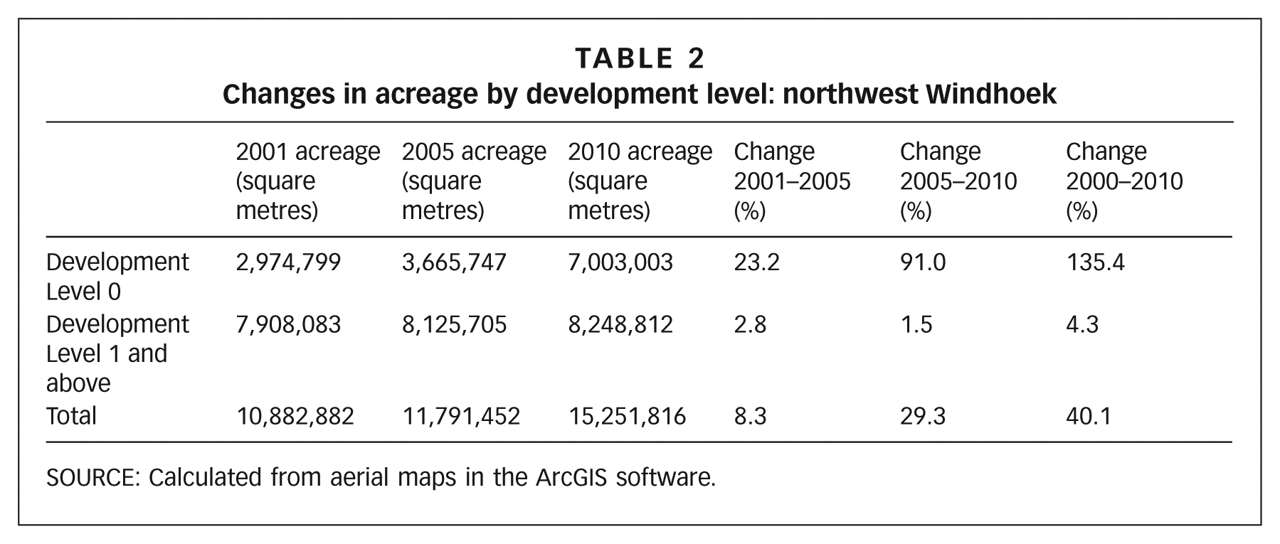
SOURCE: Calculated from aerial maps in the ArcGIS software.
With the City’s progressive strategy, it might be assumed that households would formalize their tenure and upgrade their settlements. When explaining the lack of progress, interviewees suggested that the primary consideration determining households’ preferred tenure option is cost. Given that there have not been any summary evictions since the Development and Upgrading Strategy became operational, households may choose to put their scarce resources into other investments. The consequence is that the City has preferred to invest in greenfield development over in-situ upgrading. SDFN groups continue to organize and make efforts to upgrade in part due to the insecurity (real or perceived) associated with informality. The perception of permanency associated with formalization motivates households to organize to purchase a block or individual plots. A second motivation, despite the perceived cost, is the status associated with home ownership. Eighty-five out of 90 interviewees mentioned these two factors – permanency and status – as their reasons for joining the SDFN.
When asked to explain their choice of location, interviewees explained that where families choose to settle is initially determined by who they know in a particular locality; there are other reasons for subsequent moves, including securing their own land and external factors such as the municipality policies.
In summary, the spatial form Windhoek has taken between 1990 and 2010 has entailed expansion of low-income settlements exclusively in the northwest. There is evidence that the direction of this expansion results from the City’s Structure Plans of 1996. By siting the first reception areas in the zone reserved for high-density, low-income housing, the City encouraged low-income households coming to Windhoek to settle in this area. While residents in this part of the city appear to have been largely self-directed, in practice settlement conforms to the City’s design. The ways the City determines location are further reinforced by the fact that, when upgrading is agreed upon, there is a need to decant some families to create space for social amenities or lessen densities, and the City has discretion as to where they will have to be relocated. The resulting settlement pattern at the macro level (beyond the neighbourhood) has continued to replicate the apartheid city, and while the basis for segregation may not be racial, it has certainly been social and economic.
An unintended or perhaps unaddressed consequence of the 1996 Structure Plan and the Development and Upgrading Strategy of 2000 has been the spatial marginalization of the urban poor in Windhoek. The northwest expansion of informal settlements means that the urban poor live farthest from the city centre, with increased transport costs for people already on very low incomes. A round trip into the centre of the city from the informal settlements cost N$ 10 in 2009. The affordability studies of the SDFN show that the lowest-income households would have to spend half of their monthly income on transport for one person. As well as leading to a very spread-out city, this model increases the cost of extending services to the outlying settlements. The lack of established markets (informal or formal) and trading opportunities causes further problems.(27) The consequence has been the suburbanization of Windhoek. These important planning factors do not seem to have been sufficiently taken into account.
VI. Conclusions
From independence to 2002, the City of Windhoek worked with the SDFN to find new ways to address shelter needs. The policy framework shifted considerably as a result of both commitment by City officials and politicians and pressure from the federation. The result was a more permissive paradigm, with the City adopting a new potentially radical approach to informality. It recognized the potential of the SDFN to mobilize communities to help address their own development needs.
However, the continued growth of informal settlements and the slow speed with which the upgrading strategy is delivering development makes it clear that the City is not achieving its intended progress. The number of settlements that remain at Development Level 0 suggests that the strategy is failing because it is premised on full cost recovery and an assumption that the urban poor can afford to pay for minimum services. This has slowed down the investments required for higher development levels.
While the intentions of the Development and Upgrading Strategy are to enable development, there are also contradictions in the policy. The authorities have been successful in influencing the pattern of urban development and maintaining an urban spatial form consistent with the historical division of Windhoek, with low-income households concentrated in one part of the city. The City has ensured that its spatial framework conforms to the bounds and dictates of the Structure Plan, meaning that the urban poor, living farthest from the city centre, continue to be spatially marginalized, with increased and unrealistic transport costs for people already on very low incomes.
The initial impression is that the city changed significantly from 1991 to 2011, with more progressive approaches. However, this has happened within the confines of spatial zones planned by and acceptable to the City, with expansion following the linear path the City anticipated and sought to secure through the Structure Plan of 1996. The plan established a broad vision for the city’s future development within a broadly modernistic vision that saw Windhoek as a thriving economic centre.(28) If planners were committed to social reform, they would have to radically challenge the prejudices embedded within the establishment, accepting the implications for the status quo. Despite Namibia’s independence and the democratic government of the country – and of the City – by the nationalist party SWAPO, the city’s form remains very similar to that prior to independence.
The SDFN has had an impact on the development options open to low-income households, but appears to have had little influence on the city’s spatial form at the macro level. Rather than concerning itself with this issue, the SDFN has focused on supporting member groups to meet their immediate needs. Within the context of the SDFN – a movement that is still significantly led by people who lived through the apartheid years – the present position of the state and city might still be considered quite radical. It will be interesting to see how the movement’s position shifts with time. Will a younger generation of leaders with no residual memory of apartheid act differently towards the City and demand more? Currently, whatever the people’s intention, the outcome of this process is to replicate a city segregated by income and hence, for the most part, by race.
SDI affiliates have developed their data collection processes significantly in the intervening years. By 2017, 120 cities had been profiled “citywide”. This means that data on living conditions had been collected for 85 per cent or more of the informal settlements in the city and, using GIS, the location of these settlements had been mapped. With this information, federations are informed about the patterns and location of informal neighbourhoods and able to dialogue with the city authorities about the needs of informal residents, and the patterns of urban development that are taking place.
In terms of Windhoek, significantly changing the city’s spatial form will require turning planning on its head and developing radically different ways of imagining the city. However, the urban poor can only challenge the structures that reproduce the divided city on the basis of the information they have. With information comes power, and without information the options of the poor are limited and their strategies are shaped by what they know. Knowing this, the SDFN takes a pragmatic stance in its interactions with the state, carefully weighing the risks and benefits of any decision. But the federations are also learning institutions, and as groups seek to advance their needs and interests and experience both successes and failures, they rethink their strategies. It is clear that the SDFN is currently rethinking its strategies towards neighbourhood development in the northwestern area of the city. As the costs of peripheral development become clear, demands for a more integrated city may also emerge.
Supplemental Material
chitekwe-biti-supplement – Supplemental material for Co-producing Windhoek: the contribution of the Shack Dwellers Federation of Namibia
Supplemental material, chitekwe-biti-supplement for Co-producing Windhoek: the contribution of the Shack Dwellers Federation of Namibia by Beth Chitekwe-Biti in Environment & Urbanization
Footnotes
Notes
References
Supplementary Material
Please find the following supplemental material available below.
For Open Access articles published under a Creative Commons License, all supplemental material carries the same license as the article it is associated with.
For non-Open Access articles published, all supplemental material carries a non-exclusive license, and permission requests for re-use of supplemental material or any part of supplemental material shall be sent directly to the copyright owner as specified in the copyright notice associated with the article.