
Abstract
The impacts of climate change tend to be unevenly distributed, affecting mostly urban poor communities. This research analyses the case of El Colli, a community with high levels of marginalization and urban poverty in an area characterized by informal settlements in the Metropolitan Area of Guadalajara (state of Jalisco, Mexico). The main objective was to analyse the vulnerability to climate change in El Colli, focusing on the flood risk it is exposed to and using a mixed-methods design with various research tools. The findings show the specific aspects of vulnerability in a context of urban poverty, in which basic municipal services are scarce, government action is inadequate and residents show a high acceptance of risk. Based on the data, we state the need to incorporate local urban challenges into the debate on climate change, particularly those affecting informal settlements.
I. Introduction
Climate change is a global phenomenon with a wide range of potential impacts, posing serious threats to human life and constituting one of the main environmental problems. The Intergovernmental Panel on Climate Change (IPCC) has pointed out that since the 1950s there have been significant changes in the frequency and intensity of extreme weather and climate events, exacerbating risks (and creating new ones) for natural and human systems.(1) Between 1995 and 2015, climate disasters have claimed 606,000 lives, with an average of 30,000 deaths per year. Forty-seven per cent of these events were floods, the main occurrence affecting 56 per cent of the total number of people who were affected by some form of weather-related disaster.(2)
Various risks associated with climate change (sea level rise, floods, extreme rainfall, heat increase, drought, and water shortage) have intensified, and it is expected that their impacts will be felt more acutely in urban areas.(3) In particular, climate change has an impact on regional hydro-meteorological patterns, exacerbating the occurrence of hazards such as flooding, owing to the increased frequency and magnitude of rainfall.(4) Due to factors such as population concentration, flood risk in cities is of particular concern.(5) In 2014, about 54 per cent of the world population lived in cities, and it is expected that by 2050 this proportion will go up to 66 per cent.(6) In addition to the demographic aspect, the vulnerability of cities to climate change is shaped by culture, institutional capacity, built environment, provision of ecosystem services and the environmental pressures introduced by human beings, such as water and air pollution.(7) It has also been acknowledged that certain urban economic processes, such as industrial activity, public transport and local commerce, should be taken into consideration for mitigation and adaptation purposes.(8)
The impacts of climate change are distributed unevenly,(9) due to differences in the degree of vulnerability among individuals and groups.(10) Thus, the effects are expected to fall more heavily on poor and marginalized communities.(11) Studies carried out on these aspects argue that the urban poor are especially vulnerable to climate change.(12) It should be mentioned that, worldwide, the number of people living in marginalized spaces totalled 791 million in 2000, rising to 881 million in 2014. By 2025, another 1.6 billion are expected to need adequate housing.(13)
In Latin America, the growth of cities has been characterized by irregular expansion beyond the peripheral areas, giving rise to highly marginalized informal settlements with very precarious basic services and infrastructure.(14) According to Revi et al.,(15) in low and middle-income countries, accelerated urbanization tends to be accompanied by a significant growth of potentially vulnerable communities that live in informal settlements with greater exposure to climate risks. In this sense, the poorest people suffer the most from urban transformation processes.(16)
In a 2018 article that adopts the perspective of the scientific advisory committee that led the IPCC Cities and Climate Change Conference, Bai et al.(17) suggest that informal human settlements should be one of the priority topics in climate change research. The authors emphasize the need to work on adaptation processes in these communities, as well as to carry out studies that address potential risks. They also mention the importance of including the voices of marginalized groups through the development of analytic models that take into account the sparseness of data, the informality of socioeconomic processes, and the limitations of local capacities.
These priorities are highly relevant for Mexico, where, out of 2,456 municipalities, the National Institute of Ecology and Climate Change (INECC, for its acronym in Spanish) has identified 1,385 as vulnerable to climate change and 480 as very vulnerable.(18) Since the beginning of the 20th century, climate trends in the country indicate a slight increase in the average rainfall, with greater intensification in some regional areas, such as the central-southern region of the country.(19)
Moreover, the country has high poverty rates, with 53.4 million people living in poverty and 9.4 million in extreme poverty in 2016.(20) Among the metropolitan areas of Mexico, Guadalajara has the second largest population living in areas ranked as medium to very high in the marginalization index.(21) The Metropolitan Zone of Guadalajara is located in the state of Jalisco; it had 4,865,122 inhabitants in 2015. In 2010, 27.1 per cent of the total population was considered to be living in poverty.(22) A significant portion of the territory of this metropolitan area is considered to be in a condition of marginalization, with 36.3 per cent of its neighbourhoods ranked as medium in the urban marginalization index.(23) In this context, the case of El Colli stands out, as it is one of the areas with the highest degree of urban marginalization, and is also located in a zone at high risk of flooding in the Metropolitan Area of Guadalajara. The objective of this research was to assess the vulnerability to climate change in relation to the risk of flooding in a context of urban poverty. Here, the community of El Colli was an ideal choice for a case study.
For this purpose, three specific objectives were formulated: 1) to identify the risk perception of El Colli’s inhabitants with regard specifically to their vulnerability to floods; 2) to describe the risk of this threat; and 3) to assess the vulnerability of the community. Each of these objectives involved a data collection and analysis process using qualitative and quantitative tools, which is why the methodology of this project has been described as mixed. By contrasting information obtained from various sources, this research allowed us to generate a more complete and complex image of vulnerability, which is crucial to improving our knowledge about climate change from the perspective of developing countries.
Some researchers have already started to study the implications of climate change in the context of urban poverty in informal settlements. A search for publications on the topic in the research databases ScienceDirect and Web of Science yielded research papers that also assess climate risks such as flooding in specific case studies.(24) These publications cover issues such as vulnerability,(25) resilience(26) and adaptation,(27) and contribute useful knowledge to better prepare communities to face the challenges of climate change. This article seeks to join the effort to help reduce risk and vulnerability for disadvantaged populations.
For the purposes of this research, vulnerability is defined as the inability to cope or to secure wellbeing in the face of climate change.(28) It is conditioned by a social dimension determined by socially constructed factors such as poverty, marginalization, quality of dwellings, etc. and by a biophysical dimension, determined by physical components related to certain dangers, such as proximity, location and infrastructure, among others.(29) The risk of flooding is defined as the combination of the probability of its occurrence and the potential consequences.(30) This notion of risk is related to the traditional conception, which is represented by the following equation: risk equals threat multiplied by exposure. In accordance with these definitions, the perception of risk is a fundamental aspect when trying to analyse problems of vulnerability and adaptation.(31) For the purposes of this study, risk perception includes the assessment of the subjective probability of the occurrence of a specific hazard and its potential consequences.(32)
II. Study Area
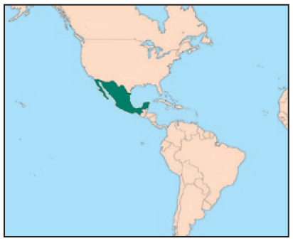
El Colli is located in the municipality of Zapopan, one of the nine municipalities that make up the Metropolitan Area of Guadalajara. The study area developed over a period of urban expansion between 1970 and 2000, during which the city spread beyond the borders of the urban periphery. It is estimated that in 1990 El Colli had 22,721 inhabitants; by 2010, the population had increased to 121,084.(33) The geographical location of El Colli is shown in Map 1.

Study area
On the east side, El Colli borders the periphery of the Metropolitan Area of Guadalajara and on the west, La Primavera Forest. The Cerro El Colli (El Colli Hill), which is part of the forested area of La Primavera, is located to the north of the area, while the city spreads towards the south. Twenty-six streams converge in this area, flowing down from La Primavera Forest towards the settlements of El Colli. The main streams are the Teistinque, Las Pilas and Arroyo Grande. Thus, urban sprawl, as it moves away from the edge of the city, tends to invade La Primavera Forest. In addition to increasing the exposure to floods due to the proximity to bodies of surface water, this creates certain risk factors, such as the change of land use and the loss of vegetation cover in a significant catchment area. El Colli has grown from an approximate area of 518 hectares in 1987 to 1,277 hectares in 2016 (figures estimated from satellite images on Google Earth).
There is no specific information available on climate scenarios for the study area. The closest weather station is Station 14169 in Zapopan, 11 kilometres away. Based on two periods of climatological normals (1971–2000 and 1981–2010), as defined by the World Meteorological Organization,(34) there has been a general increase during the rainy season for the current period at that station. Additionally, according to data from the same station, between 2010 and 2016 the average annual rainfall was 90.78 millimetres, which indicates an increase in comparison with the data that have been recorded for all decades since 1960 (see data and complete calculations in Supplement 1 available online).
Vulnerability, when associated with poverty and marginalization, most often occurs within a context where there is a shortage of basic urban services coupled with the poor quality of the built environment. This is evident in El Colli, an area that developed irregularly with the arrival of “parachutists” (paracaidistas in Spanish) – a colloquial term that, in the Mexican context, refers to low-income inhabitants who occupy land to build housing without formal or legal permits, albeit with unofficial acceptance by the government. In El Colli, 93.26 per cent of the population lives in spaces with a medium to very high index of urban marginalization(35); the settlement ranks as one of the most marginalized spaces in the Metropolitan Area of Guadalajara. Photo 1 shows a general view of the study area; note the quality of housing and the lack of infrastructure for flood prevention, which contributes to its vulnerability.
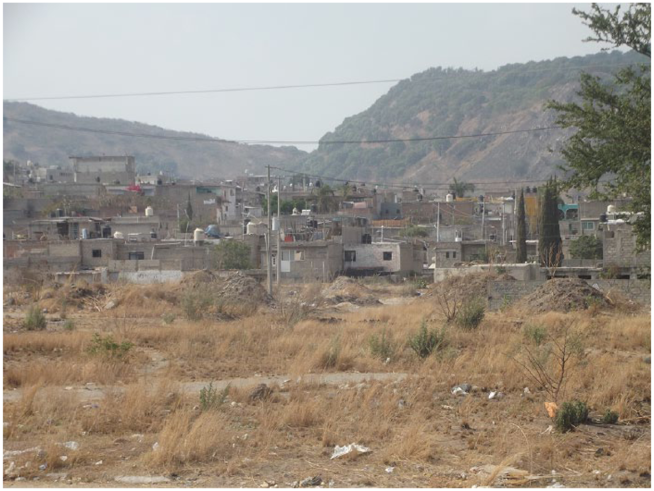
General view of the study area, El Colli
III. Materials and Methods
This research adopted a mixed-methods approach using a convergent parallel design, based on the mixed research typology proposed by Creswell and Clark.(36) In this approach, qualitative and quantitative methods are used independently for the collection and analysis of data, and the information obtained through the two approaches is then triangulated to interpret the results.
In order to achieve the objectives, the research process was carried out in three phases, one for each objective (Figure 1). Data collection required, on the one hand, establishing direct contact with the community and its inhabitants and, on the other hand, reviewing official information sources. This preliminary stage was carried out in the second half of 2017.
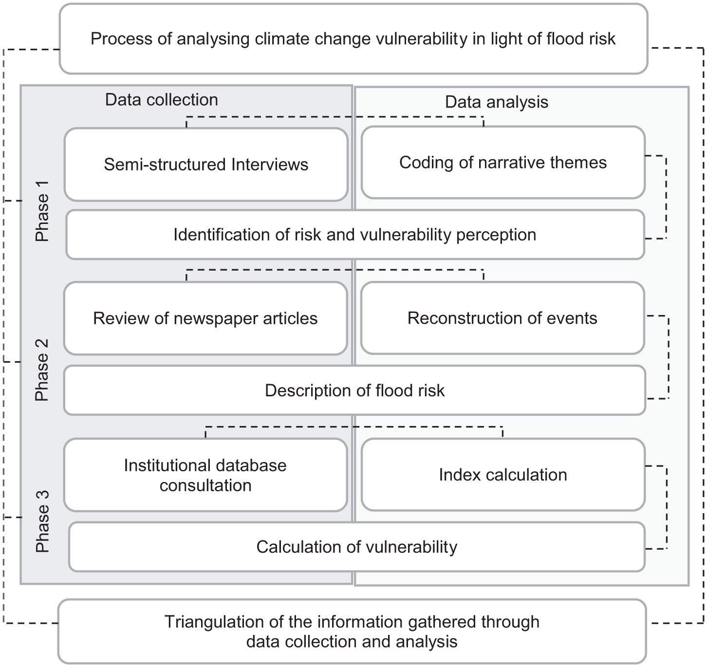
Methodological design
a. Phase 1: identifying perceptions of risk and vulnerability
For the first objective, namely identifying the perceptions of risk and vulnerability among the residents of El Colli, semi-structured interviews were conducted with heads of households. The interviews were held with a sample of volunteer participants, also known as a self-selected sample. In this type of sample, participants are chosen intentionally until a saturation point is reached.(37) For this particular case, the saturation point was reached with 27 interviews. The interviews were conducted in homes located in medium to very high marginalization index areas within El Colli. Each interview was transcribed and analysed through the coding process suggested by Saldaña(38) and Grbich,(39) and using the MAXQDA 12 software.
To conduct the interviews, a guide consisting of 40 questions, split into two main topics, was used. The two main topics were: a) perceptions of flood risk, including questions to detect the way residents describe climatic conditions and changes, identify hazard and exposure due to such changes, and interpret their experiences regarding adverse events; and b) perceptions of vulnerability to floods, including questions to capture the experiences of the inhabitants regarding floods, identify the types of actions that people undertake (or not) to protect themselves, and determine the information they have, as well as their trust in the institutions embedded in their community as support agents. A section was also added on their perceptions of the living environment, as well as questions to build their sociodemographic profile (see Supplement 2 online for the interview guide).
b. Phase 2: describing the flood risk
The second objective was a description of the flood risk, which was achieved through a reconstruction of the flood events that have affected El Colli in recent times by reviewing newspaper articles on the topic. To select the news articles, a search was carried out on the online archive of El Informador, a local newspaper. This source was selected because it is one of the highest-circulation newspapers in the state of Jalisco and because it has an open online archive. For the search, keywords such as threat, risk, flood, rain, storm and El Colli were used, as well as the names of the neighbourhoods that make up the area, such as Arenales Tapatíos, Miramar and Lomas de la Primavera.
Searches were carried out for news articles between 2011 and 2016, based on the knowledge that in those years several floods in El Colli were reported. For the analysis of the retrieved news articles, the MAXQDA 12 software was used to identity categories for each news item related to the consequences for health and life, property and the environment; responses to the events by the government and by the residents; testimonies; and facts and data of special relevance. The information collected was complemented by a request for public information addressed to the municipality of Zapopan (where El Colli is located), to provide the number of emergency events and a list of the damage caused by flooding in the study area.
To generate a more accurate description of the flood threat, additional sources of information were used to identify the houses, educational institutions, health centres, leisure and recreation spaces, and businesses with greater exposure – that is, those located at a distance of 50 metres or less from surface water bodies. The sources of information used for this purpose were the Population and Housing Census(40) and the National Housing Inventory.(41) The information was analysed with the QGIS software.
c. Phase 3: calculating the level of vulnerability
The level of vulnerability was calculated considering two factors: social and physical. The first was comprised of several variables, including education, health, housing and demographics; and the second included infrastructure and urban services. Table 1 shows the indicators for each variable, as well as the scale and data sources. The selection of these components for the estimation of vulnerability was carried out based on the availability of information in the official databases and through an extensive literature review, mainly following authors such as Adger, Brooks, Delgado and Eriksen.(42) It is worth noting that the collected data do not cover the entire territory of El Colli, since the areas that lie on the slopes of La Primavera Forest are still informal settlements for which no official data exist.
Factors used to calculate vulnerability
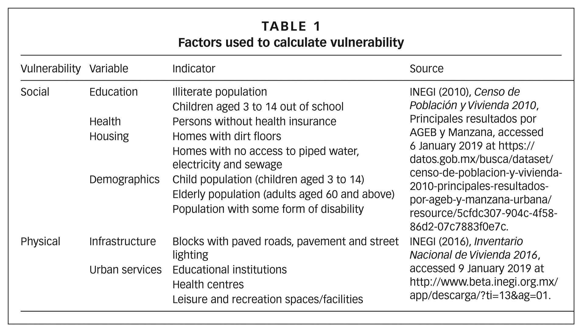
For the calculation of the vulnerability index, the normalization method was applied, a method commonly used in the literature on vulnerability to climate change.(43) The formula below was used for each indicator and then the average of the results per BGSA (Basic Geo-statistical Area) was calculated. The resulting indices are expressed in values from 0 to 19, whereby the lowest value refers to the least vulnerable area and the highest value to the most vulnerable one. To calculate the index, only social vulnerability was considered, with the information determined by BGSA (combining the data from multiple blocks would have led to error). The information was processed with the QGIS software. (See Supplement 3 online for the treatment of the data used to calculate the index.)

IV. Findings
a. Perceptions of risk and vulnerability
The saturation point in the sample of volunteer participants was achieved with 27 interviews: 22 women participants (81 per cent) and five men (19 per cent), with an average age of 48. An unexpected factor was the significantly greater participation of women compared to that of men. This gave us insight into some gender aspects in the study area: during our fieldwork, we found that women were at home or running small businesses such as grocery stores, while men travelled longer distances to get to work. The fact that women stay in the area gives them a more comprehensive knowledge of events in their environment, but at the same time, their exposure to flood events is greater. Moreover, their willingness to participate is a factor to consider when developing communication and education strategies to reduce vulnerability.
Regarding their level of education, two participants (7 per cent) had no schooling; six participants (22 per cent) had completed primary school, a grade equivalent to six school years; 12 participants (44 per cent) had finished middle school, a grade equivalent in Mexico to nine school years; three (11 per cent) had finished high school, a grade equivalent to 12 school years; another three had university degrees, equivalent to 16 years of education, approximately.
With reference to the monthly income per household, the majority of participants, a total of 15 (56 per cent), said they earned between 1,000 and 3,000 Mexican pesos (between US$ 53 and 159, according to the average exchange rate for 2018), while 12 participants (44 per cent) reported earnings between 4,000 and 6,000 Mexican pesos (US$ 212 to 318). At the time the interviews were conducted, none of those interviewed reported a household income over 12,000 pesos (US$ 636) a month, despite the fact that an average of five people per household was recorded. The possibility of a degree of error in income responses must be considered: people may have reported less than their actual monthly income for security reasons. However, when carrying out fieldwork it was possible to confirm that, in fact, the people interviewed had low incomes. This is further confirmed by the fact that 17 interviewees (63 per cent) are beneficiaries of Seguro Popular – that is, they have free medical care provided by public institutions, and only two participants (7 per cent) have private health insurance; the rest do not have any health insurance.
When asked about their reasons for moving to El Colli, the interviewees stated that their main motive was their desire to acquire a plot of land or a home of their own. The low prices for land in this area were mentioned as an important factor for choosing to live in El Colli, while the issue of the irregularity of land use was hardly raised. On average, the interviewees had lived there for 15 years and some observed that when they first came to this area, the natural environment was practically unaltered and the area lacked such basic services as street lighting, paved roads or piped water. According to the experiences of the interviewees, several neighbourhoods developed quite unexpectedly, and the population increase and the urban sprawl came as a surprise.
Regarding the perception of climate patterns over the last 15 years (counting backward from the day the interview was conducted), according to the interviewees there has been an increase in the number of hot days and a decrease in the number of cold days in the months of November and December, as well as an increase in intense cold weather days in January and February. They also mentioned an increase in intensely hot days throughout the year, especially in March and April, in addition to intensely rainy days during the rainy season, from June to August.
In terms of the dangers associated with climate change, respondents referred to floods as the most frequent threat in their community. In the second place, they mentioned forest fires and extreme heat. The interviewees did not show much concern regarding risk for any of the categories mentioned, with the exception of floods. The perception of the community is strongly shaped by past experiences of flood damage, which explains why they see this threat as the most significant.
There is a sense of fear regarding floods. The interviewees reported that every year they experience floods, which are so intense that they destroy houses, sweep away vehicles, damage household goods, and even cause fatalities. Interviewees expressed feelings of helplessness regarding the situations as they see very few options and little hope for the future. Most of the 27 respondents have had at least one flood-related experience, affecting either themselves personally (19 per cent), other members of the community (71 per cent) or both (10 per cent). Furthermore, in addition to damage to their houses, two interviewees described cases where the floods had also caused damage to businesses, an important loss considering their crucial role in providing an income. The costs to repair damage are covered by the affected parties, as there is no support from the government or any other body.
The respondents display a level of acceptance of the risk that is mainly attributable to their poverty, as they lack the resources to buy a house outside the flood risk zone. In this sense, the risk becomes “consciously” acceptable in the face of the lack of options or other economic possibilities. Due to their poverty, among other socioenvironmental factors, the inhabitants of El Colli are not only forced to live in high flood risk areas, but also are less capable of recovering from the damage. Respondents addressed this issue. As one resident stated, “Who wants to live here? I would have bought in Bugambilias [a high-income neighbourhood in the municipality of Zapopan], but our income was not high enough.”
Faced with this situation, many respondents also expressed a feeling of outrage against the authorities for the lack of concrete actions to reduce the flood risk. Some respondents went as far as to express a deep distrust of government institutions. It was mentioned, for instance, that bodies such as the Unit for Civil Protection and Firefighters do not provide the necessary support to prevent flood hazards in El Colli. Interviewees who had more direct experience of floods showed greater dissatisfaction, as they have had to manage the risk on their own, resorting to measures such as using bricks to raise their furniture above flood level and placing sacks full of rubble so as to prevent the water from running into their homes. These adaptation measures are carried out individually. Despite the magnitude and frequency of the risk and the effects of floods, so far no joint efforts have been organized to establish community strategies in El Colli.
b. Description of flood risk
The search of the online library of the newspaper El Informador yielded a total of 32 news articles dealing with cases of flooding in El Colli between 2011 and 2016. The highest number of articles retrieved was for 2013, with a total of 12, followed by nine for 2012, five for 2014, four for 2015 and two for 2016. Of the 32 references obtained with this search, 83 per cent reported mainly consequences for property, 14 per cent consequences for health and life, and 3 per cent consequences for the environment.
The flood events that occurred between 2012 and 2016 affected 316 dwellings, with the greatest damage reported in 2012 and 2013. It should be noted that household goods are not mentioned in the news articles, only damage to buildings. Nor do the news articles report official figures of damage to public infrastructure, although there are references to severe damage to roads, a public transport vehicle, a drainpipe, and structures that protect against heavy rainfall, among others. Additionally, damage to businesses, homes and household goods is reported through testimony cited in the news articles. Only one fatality was recorded during the 2011–2016 time period.
This reconstruction of past events indicates that floods in El Colli affect mainly the houses near streams and that, given the poor quality of the construction materials used, they suffer severe damage. The most affected neighbourhoods during the rainy season, as recorded in the news articles, are usually Arenales Tapatíos, Carlos Rivera Aceves, Miramar, Lomas de la Primavera, 12 de Diciembre, El Rehilete and El Tizate. Up to 63.7 per cent of the population of El Colli, or 77,740 people, live in these neighbourhoods.(44)
The incident with the highest impact occurred in 2012, after heavy rainfall on 6 October, with a large number of people affected and one fatality. The municipality set up two shelters for people who had to abandon their homes and spoke of mandatory eviction of those with homes at risk of collapse due to weakening caused by the floods. Eight families were removed as required, according to news articles.(45) In 2013, it was reported that the authorities had established the need to relocate 150 families of El Colli who were living in high-risk areas close to streams.(46) Reports noted that authorities were “searching” for public works solutions that would contain the waters.(47) In the absence of solutions to the risk, the inhabitants of the area have demanded information and clarity on any measures the local government plans to adopt to address this issue.
On 14 June 2014, it was reported(48) that the authorities tore down 20 homes in the neighbourhood El Tizate, arguing that they were informal houses located in a flood risk zone; six of these dwellings were made only with sticks and tarps. In the news reports, the residents who had been evicted mentioned that they were only given 30 minutes to gather their belongings before their houses were demolished. The Zapopan government declared that it would not provide any help to relocate them, since their homes were informal.
Between 2015 and 2016, as in previous years, the authorities informed residents that their homes were in high-risk areas, but according to the director of the Unit for Civil Protection and Firefighters of Zapopan, only five out of every hundred persons were willing to vacate their homes voluntarily. However, it was also reported(49) that the mayor of Zapopan, during the 2015–2018 period, periodically declared that he intended to carry out demolition works to prevent flooding in the neighbourhoods of El Colli, although no specific details were provided.
To compare these data, a request for public information was made to the City of Zapopan through the transparency platform Infomex (registered under Folio 2166217), which allows specific information to be requested from different authorities in the state of Jalisco. Information on the number of floods that occurred between 2012 and 2016 in El Colli was requested with a breakdown by year and neighbourhood, indicating their specific effects on the residents, assets and environment of the community. The response of the authorities indicated that there was no record of flood-related emergencies for this period, nor of any kind of damage – a response that differed significantly from the information obtained from the interviews carried out for this research.
The proximity to the numerous streams in the area places many of El Colli’s significant assets under the threat of flooding. In total, there are five educational institutions, three health centres and social assistance facilities, two recreation units, 83 shops and 322 blocks in an area within 50 metres of the streams. The data provided by INEGI indicate that the area consists in total of 1,552 blocks, with an average of 28 dwellings in each block.(50)
c. Calculation of vulnerability status
According to the last national census carried out in 2010, a total of 44,275 El Colli residents live in areas with a high or very high marginalization index. This figure represents 36.57 per cent of the total population of this zone. There are 8,278 homes located in areas with this degree of marginalization, representing 34.86 per cent of the total. In terms of urban infrastructure, the coverage of basic services in El Colli is severely deficient: of its 1,552 blocks, only 703 (45.3 per cent) have paved roads, 827 (53.29 per cent) street lighting and 582 (37.50 per cent) sidewalks. The coverage of other services, such as education, healthcare, and leisure and recreation, is also insufficient, with fewer than one centre per thousand inhabitants.
Map 2 shows the result of the calculation of the vulnerability index, on a scale from 0 to 10, whereby the lowest value refers to the less vulnerable BGSAs (Basic Geo-statistical Areas) and the highest value to the most vulnerable. The values indicate that 10 of the BGSAs, equivalent to 20 per cent of the total territory of the study area, are ranked between 4.22 and 9. The neighbourhoods with the highest vulnerability index are Arenales Tapatíos, El Rehilete, Lomas de la Primavera, Colinas de la Primavera, Carlos Rivera Aceves, 12 de Diciembre and La Gloria, with a population of 40,155 – that is, 33 per cent of the total population of the study area.
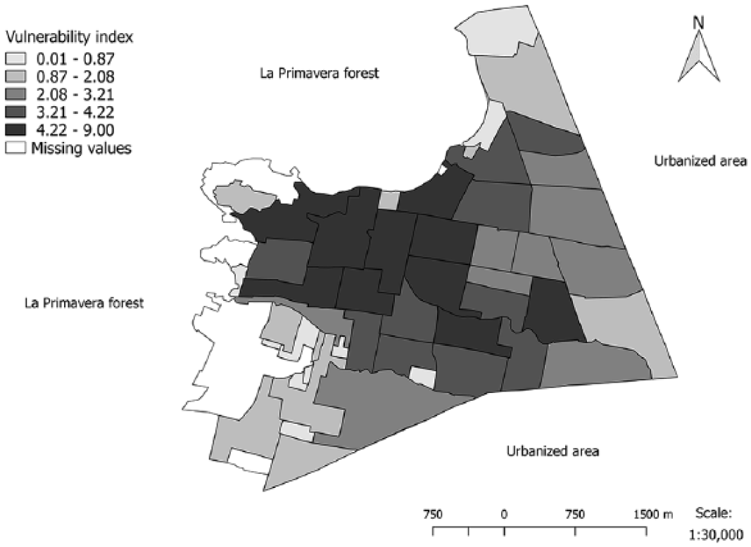
Vulnerability index for the territory of El Colli
It is worth mentioning that there is a significant number of missing values for the areas located on the banks of La Primavera Forest and El Colli Hill, which are also the areas that according to the available data have less coverage of municipal services and infrastructure. This is because these are informal settlements and, thus, do not figure in the official databases.
V. Discussion
The field of studies on climate change vulnerability has grown in recent years and a series of interpretive frameworks and methodologies have been put forward.(51) In this research project, we have carried out a vulnerability assessment using a mixed-methods process to analyse and compare data collected from various sources. This has enabled us to provide a more complete picture of the prevalence of flood risk in a specific context of urban poverty. The main finding of the study has been a determination of the degree of vulnerability in a context of urban poverty in the case of a specific local community in Mexico.
This research has established that, according to the testimony of the inhabitants of El Colli, floods pose the greatest risk associated with climate change. According to the experiences of the interviewees, there is a feeling of fear and uncertainty, along with an acceptance of the high risk associated with the state of urban poverty. That is, due to the lack of other options, people under this condition opt for housing in spaces with greater exposure to risk, a conclusion that has been reached in other studies.(52)
Marginalization plays an important role in the state of vulnerability, as it is associated, in the case of El Colli, with irregular settlements located in spaces with greater exposure to environmental risk and with a shortage of basic municipal services. A number of authors(53) recognize that inhabitants of spaces with these characteristics lack services in comparison with those of other socioeconomic strata, which increases vulnerability to flooding, especially in a context of climate change. The calculation of the vulnerability index for El Colli shows a trend towards greater vulnerability as the settlements move away from the urban periphery, which will continue to increase as expansion continues into this still informal area.
A comparison of the data obtained from the sources used for this project regarding the flood events in the study area revealed a disparity between the testimony of the interviewees and the reviewed news articles. The inhabitants mentioned that every year there is damage to property and even fatalities due to floods, while the media reported fewer adverse events over the years. The information provided by the municipal government authorities does not record any flood-related emergencies in the area between 2012 and 2016. Therefore, in the presentation of risk, it can be assumed that the inhabitants of El Colli have been excluded; Beck(54) argues that risks become real for society only if they can be defined as such, but also if they are successfully “staged”, mainly by experts such as the media and public officials. In the case of El Colli, the facts have not been considered as part of the scenario.
For this particular case, we consider that improving the government response to flood risks and flood events would significantly supplement the response capacity of the inhabitants of El Colli vis-à-vis these issues. Both the news articles reviewed and the testimony of interviewees revealed that the response of the authorities to this problem has been inadequate. Consequently, members of the community have taken their own measures to prevent flood damage; however, given the magnitude of the risk, these measures have been insufficient. Additionally, the community lacks the organizational structures to coordinate communal adaptation actions. When carrying out this research, we found there was a significant crime problem in the area. We assume that this factor can partially explain the lack of communal organization, but further research is needed in this regard.
We believe that an emphasis on gender could be used favourably to strengthen the response capacity of the community. The interviews and the fieldwork for this project revealed that women have a greater presence in the study area and stronger links with other members of the community. They could be leaders and promoters of the organization that is required to develop concrete actions towards adaptation and vulnerability reduction. This kind of action arising from the community could exert pressure on the authorities and provide the right orientation for the kind of response that is needed. Hossain and Rahman(55) have pointed out that, among the urban poor, significant transformations in terms of adaptation to climate change have materialized through negotiation and cooperation with government actors. Bulkeley’s article(56) on climate change and governance is also important for this discussion.
The literature dealing with the impact of climate change on people living in poverty and in informal settlements frequently highlights the importance of government action in the processes of adaptation and vulnerability reduction.(57) In the case of El Colli, the municipal government does not display any commitment regarding the problems posed by frequent flooding. Changing this attitude is in itself a challenge for the inhabitants of the study area, where approaches such as community organization,(58) co-production of knowledge,(59) and attention to the gender dimension would provide key tools for addressing climate change. For example, a very useful tool would be community risk maps, which could be created by taking these approaches into consideration with the participation of the different members of the community to identify the main risks and the points of greatest exposure in their daily environment. We believe that this study provides the basis to develop such a tool.
VI. Conclusions
In this article, we have presented a climate change vulnerability assessment for a local urban poor community living in an informal settlement with high exposure to flood risk. We have taken as a case study the community of El Colli, located in the Metropolitan Area of Guadalajara, in the state of Jalisco, Mexico. We have described the situation of this community in terms of flood risk, showing that the condition of urban poverty involves issues such as high risk acceptance by the inhabitants, disparity between the experiences of the residents and the reports in local newspapers, lack of basic services in the home and in the area at large, and low support from the authorities to establish concrete measures to reduce risk and vulnerability.
The limitations faced with this research had to do mainly with the availability of data due to the scale of the territory and to the environment of urban poverty. In particular, we found that no work has been done to develop local models of climate change, a lack that was observed at both the metropolitan and state levels. To correct the lack of data, we implemented diverse methodologies to collect information from the different sources that were available. For future research at the local level and in urban poverty contexts, it is necessary to continue formulating methodologies that make the best use of available resources through qualitative and quantitative tools, as argued by Delgado and Gulbrulnet.(60) It is crucial to continue producing information about the conditions faced by this type of urban poor community in an informal settlement, in order to generate the necessary knowledge to promote more robust adaptation strategies and reduce vulnerability to climate change in these areas.
In addition to the above, this research supports the thesis that a mixed methodological approach produces outcomes that can be used as inputs for the design of strategies to reduce vulnerability. For the specific context of the case study, we suggested a series of strategies (Supplement S4 online). It should be noted that the application of these strategies requires further analysis, and they are mentioned here to exemplify the way our findings allowed us to put forward some possible options to reduce vulnerability.
El Colli is a community demonstrably vulnerable to floods. This risk can be exacerbated by the effects of climate change. However, establishing a link between vulnerability to floods and climate change in El Colli requires the generation of local climate models. It is urgent that this type of information be produced to determine more clearly the implications of adaptation and vulnerability reduction in contexts similar to those of El Colli. The first data that we generated from the analysis of perception indicate a strong correlation with the existing climate data on precipitation, which has been increasing in recent decades.
This case study represents a small portion of the reality of urban poverty and informal settlements in Mexico. There are many other communities like El Colli, living in precarious conditions and unprepared to manage the effects of climate change. We carried out this research taking into consideration the Edmonton Declaration, issued during the IPCC Cities and Climate Change Science Conference, held in 2018 in Edmonton, Canada. This highlights the need to pay special attention to small and medium-sized cities, as well as to informal settlements, so that they are adequately included in the debates on climate change, since they generally lack the technical capacity, resources and basic data for decision-making at the local level. We see our study as a contribution in this sense, at the same time that we acknowledge that the findings need to be strengthened with additional studies that consider this scale.
Supplemental Material
EAU827850_supplemental_material_1 – Supplemental material for Climate change and flood risk: vulnerability assessment in an urban poor community in Mexico
Supplemental material, EAU827850_supplemental_material_1 for Climate change and flood risk: vulnerability assessment in an urban poor community in Mexico by Juan Alberto Gran Castro and Silvia Lizette Ramos De Robles in Environment & Urbanization
Supplemental Material
EAU827850_supplemental_material_2.pdf – Supplemental material for Climate change and flood risk: vulnerability assessment in an urban poor community in Mexico
Supplemental material, EAU827850_supplemental_material_2.pdf for Climate change and flood risk: vulnerability assessment in an urban poor community in Mexico by Juan Alberto Gran Castro and Silvia Lizette Ramos De Robles in Environment & Urbanization
Supplemental Material
EAU827850_supplemental_material_3 – Supplemental material for Climate change and flood risk: vulnerability assessment in an urban poor community in Mexico
Supplemental material, EAU827850_supplemental_material_3 for Climate change and flood risk: vulnerability assessment in an urban poor community in Mexico by Juan Alberto Gran Castro and Silvia Lizette Ramos De Robles in Environment & Urbanization
Supplemental Material
EAU827850_supplemental_material_4 – Supplemental material for Climate change and flood risk: vulnerability assessment in an urban poor community in Mexico
Supplemental material, EAU827850_supplemental_material_4 for Climate change and flood risk: vulnerability assessment in an urban poor community in Mexico by Juan Alberto Gran Castro and Silvia Lizette Ramos De Robles in Environment & Urbanization
Footnotes
References
Supplementary Material
Please find the following supplemental material available below.
For Open Access articles published under a Creative Commons License, all supplemental material carries the same license as the article it is associated with.
For non-Open Access articles published, all supplemental material carries a non-exclusive license, and permission requests for re-use of supplemental material or any part of supplemental material shall be sent directly to the copyright owner as specified in the copyright notice associated with the article.