
Abstract
Rapid urbanization and climate change together increase the vulnerability of poor urban communities to natural hazards, undermining urban resilience. It is therefore critical to identify and deepen our understanding of the main variables, and the complex interactions between them, producing and shaping the vulnerability of poor urban communities to natural hazards. Identifying factors that challenge or support the efforts of these communities in responding to hazards is also helpful in policymaking for urban resilience. To develop this understanding, it is necessary to conduct detailed research at the local scale. This paper aims to contribute to this knowledge by applying participatory modelling techniques to a particular case study of an informal settlement in Durban, South Africa. The aim is to elucidate how this detailed empirical research can contribute to broader theoretical knowledge on urban vulnerability and resilience in the face of climate change and rapid urbanization.
I. Introduction
Rapid and unplanned urbanization, in combination with the impacts of climate change, increases the vulnerability of the urban poor to natural hazards. Currently 3.9 billion people, or just over half of the world’s population, reside in urban areas.(1) This number is projected to rise to 6.3 billion by 2050, when 66 per cent of the world’s population will be considered urban. In absolute terms, this represents an addition of approximately 2.4 billion people to the global urban population.(2) This rapid urbanization process, which will largely take place in cities and towns of the global South, poses significant challenges to both authorities and ordinary citizens, as the majority of these fast-growing urban areas already have high levels of poverty, unemployment, informality and environmental risk, as well as housing and service backlogs.
The rapid growth of cities places pressure on the state and civil society organizations to provide adequate and affordable shelter and services for the urban poor, especially new migrants. Insecure employment and unemployment, poverty, the lack of alternate housing opportunities, social and economic exclusion, and the need to be located close to urban resources and opportunities, result in the urban poor claiming their right to the city through the establishment of informal settlements. Informal settlements, defined as unplanned residential areas “where housing, shelter and services have been constructed on land to which the occupants have no legal claim, or which they occupy illegally”,(3) can therefore be seen as one of the many outcomes of unequal and uncontrolled urbanization.(4) With the overall number of people residing in informal settlements globally estimated to be increasing by 10 per cent each year,(5) it is critical to understand the risks, costs and opportunities of this form of urban settlement, particularly in relation to the increasing environmental risk produced by climate change. The risks associated with the combination of rapid urbanization and climate change therefore require that climate variability, and its relations to the socioecological, political and economic dimensions of life in informal settlements, are understood in more depth.(6)
Climate change projections indicate significant increases in the frequency and intensity of natural hazards, in particular storm events and floods, which are the natural hazard most frequently experienced by the urban poor.(7) The location of informal settlements on floodplains, and their insufficient waste and drainage networks, combined with higher runoff from hardened surfaces such as roads and pavements, compound the impact of flooding on the urban poor.(8) Impacts from flooding include loss of informal housing, inundation, soil erosion, poor water quality, injury and death, as well as disruptions to livelihoods and city economies, damage to homes, assets and public infrastructure, population displacement, and the spread of diseases.(9)
The increasing exposure of poor urban residents to natural hazards both accentuates and changes the relationship between communities and their biophysical environment. An understanding of the uncertainties around the evolution of codependent environmental, political and socioeconomic processes is therefore critical in building urban resilience in the face of climate change.(10) This is an area in which further knowledge is required.(11) This paper aims to contribute to this knowledge by exploring the relations among environmental, socioeconomic and governance processes at the local scale where these challenges are most intense, using an informal settlement in Durban, South Africa as an example. Knowledge of environmental risk and urban vulnerability in this context is constructed through detailed empirical research, conducted in the Quarry Road West informal settlement. However, this understanding and knowledge needs to be scaled up to be useful to resilience building at the city, regional, national or global scale.(12) The particular historical and geographical contexts of specific informal settlements change how the relations among risk, vulnerability and resilience are assembled, creating a wide range of outcomes that require the response of policymakers and authorities. This raises the question of practice: How can the rich and varied empirical data and research produced in the global South be translated into universal theories and general models of urban resilience? And can this universalization of knowledge lead to transitions toward greater sustainability?
II. Natural Hazards, Urban Vulnerability and Resilience
The importance of assessing urban vulnerability to natural hazards, emphasizing the necessity for increased resilience to achieve sustainable development, has been highlighted by several national and international organizations.(13) Natural hazards are defined as natural processes or phenomena “that may cause loss of life, injury or other health impacts, property damage, social and economic disruption or environmental degradation” .(14) The likelihood and extent of adverse effects are determined by vulnerability, produced through susceptibility and ability to cope. Alternatively phrased, the likelihood and extent of these effects are a function of exposure, sensitivity and adaptive capacity.(15) In the urban context, the determination of vulnerability to natural hazards considers how climate change may alter the exposure and sensitivity of urban populations, with a particular emphasis on social, economic, political and environmental issues with which climate change combines to produce risk.(16) Resilience, seen as an antonym of vulnerability,(17) is the ability of a system to rebound or bounce forward after a period of stress.(18)
It is therefore critical not only to identify disturbances that urban areas may experience, and to increase urban resilience through appropriate disaster risk management and landscape and urban planning,(19) but also to develop an understanding of the main interacting components determining social and biophysical vulnerability in urban areas.(20) This research focuses on the interaction of multiple variables in producing vulnerability to flooding in an informal settlement in Durban. It uses the concept of a socioecological system(21) to explore the connections between this social system and its biophysical environment. The complexity and multifaceted nature of risk from natural hazards further mean that the response to the hazard cannot be undertaken by one single actor, but require a move from dependence on unipolar government to multipolar governance.(22) Governance, in the context of risk, is understood as a “multitude of actors and processes” collaborating in decision-making procedures.(23) In essence, effective governance can decrease vulnerability of socioecological systems to climate-induced natural hazards and strengthen resilience.(24)
Governance for climate change requires both vertical and horizontal integration of governance processes, supporting the inclusion of multiple actors, the state, private sector and civil society into policymaking.(25) While international and national policy agendas dealing with climate change shape the success of adaptation processes, local authorities are considered to be critical to successful climate change governance.(26) This is because they are located at the closest interface to citizens and environmental change and therefore can build inclusionary and participatory processes within affected local contexts, supporting improved state–citizen relations, which have been shown to be essential for climate adaptation.(27) Governing climate change adaptation and building resilience in urban areas takes place at the local, regional and national levels, and across different temporal scales, necessitating the elucidation of a multitude of complex interactions between natural and human systems. Policy and management efforts therefore need to consider these complex interactions.(28) This multilevel approach provides a frame within which to analyse the complexities of local urban governance and to examine the interdependent and interrelated fields of urbanization, environmental quality and poverty.(29)
This paper explores urban vulnerability in relation to climate change in informal settlements through a socioecological systems analysis, and further reflects the need for “integrative approaches that are capable of analysing and elucidating the dynamic effects of interdependencies”.(30) Our objectives therefore are to identify key variables within the socioecological system, and to define the relationships between these variables. This form of analysis illuminates the relations and codependencies among environmental, political and socioeconomic dynamics in informal settlements in the face of natural hazards. By identifying and examining the main socioecological processes in the Quarry Road West informal settlement in Durban, this research demonstrates how critical issues affecting the vulnerability of the informal community, with a particular reference to flooding, could be identified, and the relations between them understood. This study can be seen as a prequel to a governance assessment,(31) with findings providing emerging knowledge for local adaptation and serving as an analogue for similar urban socioecological systems vulnerable to climate change elsewhere.(32)
III. Quarry Road West Informal Settlement, Durban
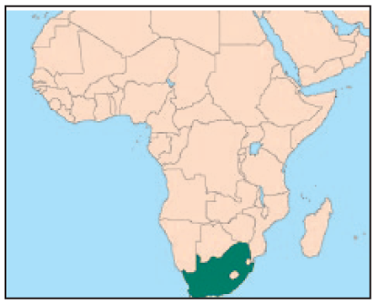
Quarry Road West is an informal settlement located in the urban core of Durban, or its administrative entity eThekwini Municipality, South Africa. It is officially home to 550 households or approximately 1,640 residents, though unofficial figures are twice as high. Residents have illegally occupied the land and do not have formal security of tenure. However, given the relatively progressive approach to informal settlements in South Africa and Durban, residents have some legal protection here, as households cannot be evicted from the site without a court order. The settlement is located in Ward 23 of eThekwini Municipality on a precarious site on the floodplain of the Palmiet River (Map 1). The Palmiet River is 26 kilometres in length and originates in the Kloof escarpment.(33) Its headwaters are located at an elevation of 510 metres above the mean sea level, and it flows through the Quarry Road West informal settlement at an elevation of 18 metres above mean sea level.
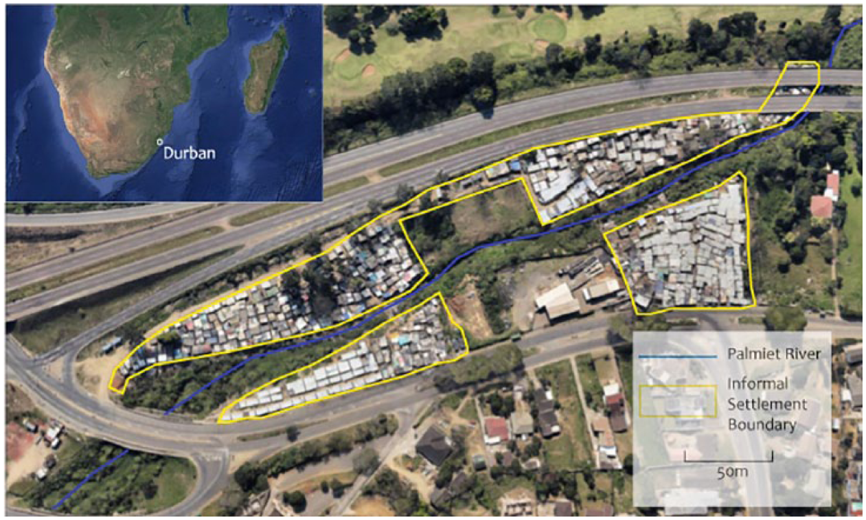
Four sections of the Quarry Road West informal settlement, intersected by the Palmiet River flowing from west to east
The catchment, described as steep and undulating, is 37 square kilometres in extent and heavily urbanized.(34) Changes in the river’s water levels are determined largely by summer rainfall, which results in peak discharge between October and March.(35) The Palmiet River reaches peak discharge very quickly after heavy rain due to the steep, highly modified catchment. The flooding risk associated with this river encouraged the municipality’s Coastal, Stormwater and Catchment Management (CSCM) Department to develop an early flood warning system for the river using its newly established radar monitoring system at the University of KwaZulu-Natal (UKZN). Flooding in the Quarry Road West informal settlement is not caused only by the Palmiet River. Unmanaged stormwater flow emanating from the roads surrounding the settlement can cause even more damage than the river during storm events. For a more detailed demographic description and history of flooding in the settlement, the context of urbanization dynamics in Durban, and climate projections affecting the exposure of residents to flooding, please refer to Williams et al.(36)
IV. Methodological Approach
Participatory systems mapping is an analytical approach that can reveal the complexities and connections between variables in a socioecological system by integrating and mapping stakeholder knowledge, and was thus selected as the method for this study. The importance of stakeholder participation has been highlighted in the context of sustainable disaster risk management.(37)
a. Participatory systems mapping
System dynamics is primarily a modelling methodology applied to improve understanding of dynamic behaviour and feedback patterns within complex systems.(38) Collste et al. further describe system dynamics modelling as a “systems analysis approach that is used to study behavioral patterns of systems”.(39) As Pruyt explains, this can be applied to “describe, model, simulate and analyze dynamically complex issues and/or systems in terms of the processes, information, organizational boundaries and strategies”.(40) The aim when building system dynamics models is to model the perceived underlying structure of a system.(41)
The system itself has boundaries. Interactions are created between components of a system within a boundary,(42) separating the “dynamically significant inner workings of the system from the dynamically insignificant external environment”.(43) System dynamics also allows for the consideration of non-linear causal relationships – an important criterion when considering complex systems.(44) System structures should include physical and informational aspects, as well as policies and traditions influencing decision-making processes and affecting system behaviour. When undesirable behaviours are to be improved, the variables and their causal relationships can be identified, and an attempt can be made to change the underlying structure of the system.
Participatory systems mapping is a form of system dynamics,(45) and can be used to maximize the involvement of stakeholders during the data collection phase.(46) Using participatory systems mapping as an approach for sustainable development research has previously proven successful, in particular due to the possibility of including the perspectives of stakeholders, and of integrating information, both scientific and contextual, from a broad range of disciplines.(47) It has been argued that this form of predetermined social interaction can facilitate social learning between participating stakeholders and help bridge the science–policy gap.(48) In participatory and mediated modelling, various stakeholders (including community members, government officials or business representatives) can use system dynamics tools as a basis to produce simulation models.(49) The direct inclusion of stakeholder data during the model-building phase further enhances the accuracy and authenticity of the model, and increases the legitimacy of the process.(50) One of the distinct advantages is the ability to incorporate previously marginalized communities and include local knowledge and perceptions, which is essential for improving quality of life and reducing risk in informal settlements.(51)
The application of participatory modelling via a participatory systems mapping exercise results in a collective causal map, which is a simplified form of a systems model. Collective causal maps form the initial structure of system dynamics models, displaying the causal hypothesis through a simplified representation of the model.(52) Though it is not possible to quantify and simulate this conceptual and diagrammatic model, this method has proven highly effective in scoping complex issues and in furthering understanding of the dynamic characteristics of the system.(53) As a diagnostic tool for issue identification and conceptualization, the causal map can incorporate a broad synthesis of information gathered. Collective causal maps can also be effective tools for diagnosing causal relationships and identifying potential risk management and risk mitigation options.(54)
Conducting preparatory interviews prior to the participatory systems mapping exercise is recommended to identify key variables of the system, which are then corroborated during the exercise itself.(55) Thus, participatory systems mapping was undertaken for this case study in three stages to build a systems model of vulnerability to flooding in the Quarry Road West informal settlement. First, important stakeholders from eThekwini Municipality, local research institutes, civil society organizations and the community were identified for consultation. Second, to initially identify key variables within the socioecological system, preparatory semi-structured interviews were carried out with stakeholders who had sound knowledge of the settlement and its relationship with the Palmiet River. Third, to confirm the key variables identified during the interviews, and to establish the causal relationships between these variables, a participatory systems mapping exercise was undertaken with six members from the Quarry Road West informal settlement.
b. Three stages of research
Phase 1: Consultations with local experts
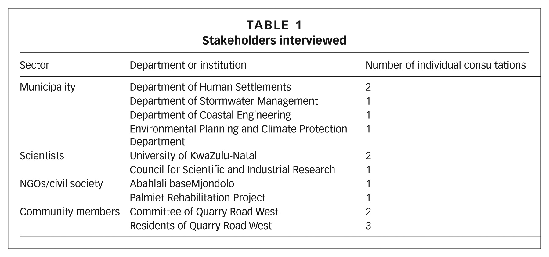
Officials from various departments in eThekwini Municipality who have a responsibility for, or an interest in, the Quarry Road West informal settlement were interviewed, as were two representatives from the School of Built Environment and Development Studies, University of KwaZulu-Natal, who are conducting research in Quarry Road West. Interviews were also conducted with a local hydrology expert from the Council for Scientific and Industrial Research (CSIR) and representatives from Abahlali baseMjondolo, a social movement concerned with the rights of the urban poor, as well as with the members of the Palmiet Rehabilitation Project (PRP), a community-based organization dealing with water and climate governance of the Palmiet Catchment.(56) Finally, conversations and interviews were undertaken with residents and committee members of the Quarry Road West informal settlement. Table 1 lists the stakeholders interviewed. They have been kept anonymous; however, their sectors and departments are shown.
Stakeholders interviewed
Phase 2: Semi-structured stakeholder interviews
Semi-structured interviews were carried out with all of the stakeholders who had been purposively selected for their detailed knowledge of the relationship between the informal settlement and the Palmiet River. They were asked to identify key variables influencing the vulnerability of Quarry Road West to climate-induced natural hazards. Interview questions were categorized in accordance with the IPCC’s definition of vulnerability.(57)
Information pertaining to exposure was gathered on past and present climate observations, as well as expected future climate developments, in order to determine perceived climatic trends, variability and extremes.(58) Stakeholders were also asked about frequency, timing, duration and extent of flooding. Questions focused on causal and contributory factors leading to flooding, as well as specific locations within the settlement where flooding was most intense. The tradeoffs selected by the community members in deciding to settle in environmentally risky areas were also discussed.(59)
Information on sensitivity was gathered by discussing the extent of damage and destruction in the aftermath of a flood. When a flood occurs, the nature of the impact affects different parts of the system in different ways. It was therefore important to establish preconditions such as the quality of public services and basic infrastructure, as well as the levels of residents’ education and health.(60) The nature of the interaction between residents and their natural environment can also affect the impacts of flooding, as well as the level of knowledge and awareness of flood risk and potential climate change impacts.(61) Stakeholders were asked to identify groups particularly affected by flooding, and whether social or spatial factors influenced their sensitivity.
Data on adaptive capacity were gathered through questions relating to the holistic response in the immediate aftermath of flooding, not only by community members themselves, but also by the municipality, scientists, NGOs and civil society. The effectiveness of previously implemented adaptation measures was discussed, along with the reasons for their success or failure. This included discussion of social networks, local knowledge, institutional arrangements, and natural and economic resources.(62) Data on economic status and assets were also gathered, as access to financial resources affects the ability to adapt to flooding.(63)
Phase 3: Participatory mapping exercise
Key variables and causal relationships characterizing the dynamic problem, in particular between ecological and economic issues, were discussed during the participatory modelling session, conducted in the isiZulu language with six residents of the Quarry Road West informal settlement.(64) This allowed for the inclusion of knowledge that had not previously been considered. Additionally, two interpreters and one model-builder/facilitator took part in the session. All participants were involved to the same degree and the session lasted for approximately three hours. The resulting collective causal map was then supplemented with information gathered previously during the semi-structured stakeholder interviews.
The flooding of the Palmiet River was identified by the participants as the main natural hazard in the settlement at the beginning of the modelling exercise. The deliberations among the participants over the variables producing and shaping the community’s vulnerability to flooding were then allowed to flow freely, with some interventions from the model-builder/facilitator to guide the process when clarity was required. The narratives were recorded by the model-builder/facilitator using a large poster as a model interface, smaller coloured cards for the key variables, and markers for the causal relationships between the key variables. The participants were invited to mark causal relationships between key variables themselves. This maximized stakeholder participation and encouraged the co-production of knowledge as well as the co-design of the model.
V. The Collective Causal Map for Vulnerability to Flooding in the Quarry Road West Informal Settlement
The collective causal map (Figure 1) identifies variables of interest underpinning or driving the vulnerability of the socioecological system, and defines their causal relationships, which are represented by arrows. The nature of the relationships is shown through the arrow line style, with solid lines expressing positive polarity/correlation (if one variable goes up, the other variable goes up), and dotted lines expressing negative polarity/correlation (if one variable goes up, the other variable goes down, and vice versa). Once the causal map was constructed, the relations between the variables were presented in a range of narratives that explained and attempted to account for these relations. Letters have been assigned to each variable to assist in connecting the narrative to the model. Understanding the historical and geographical context of the settlement is critical in understanding the relationships between the variables.
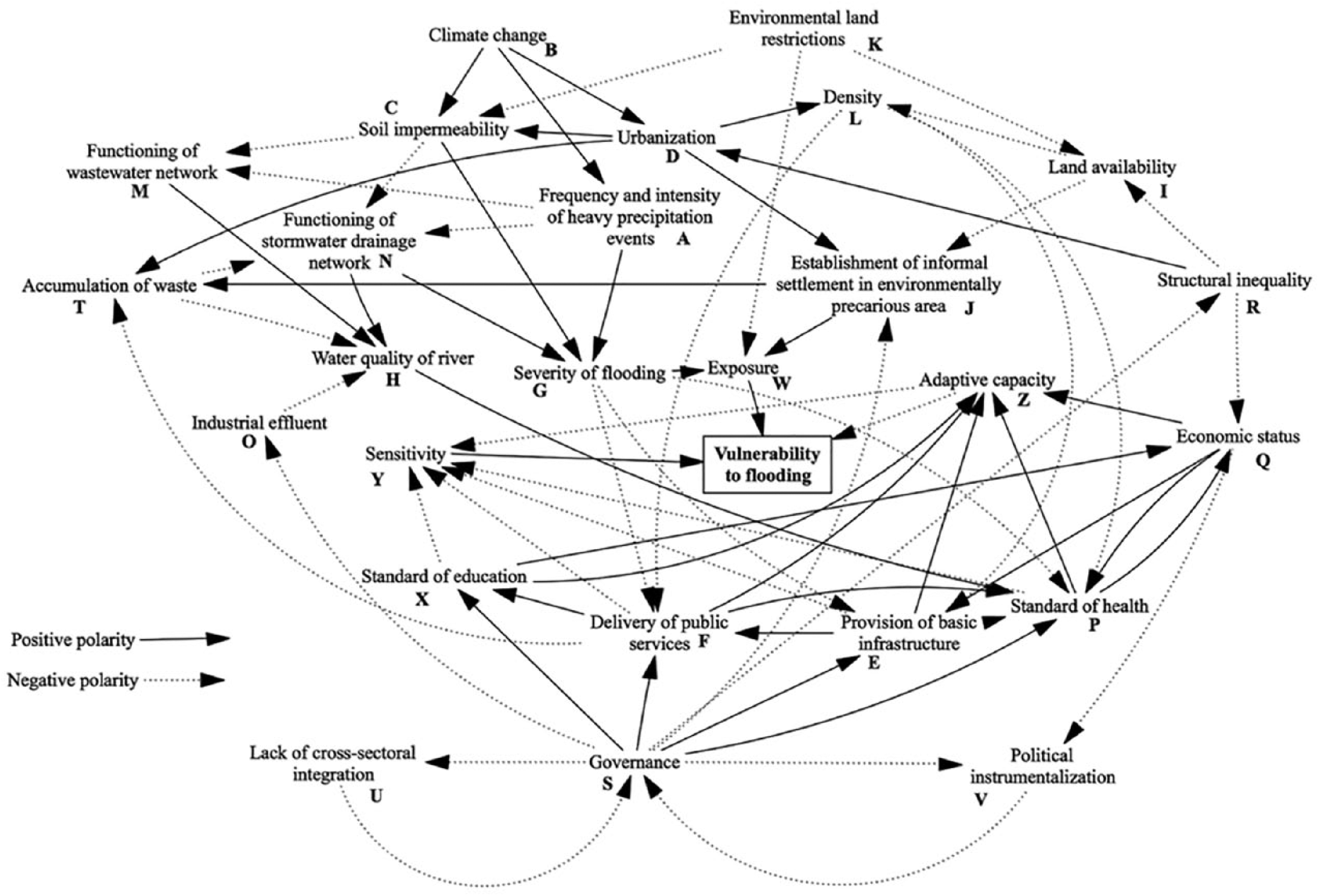
Collective causal map constructed during the participatory systems mapping exercise with community members, with supplementary data from stakeholder consultations incorporated
Stakeholders from most sectors have already observed an intensification of precipitation events (A) over recent decades, with a shortening of the recurrence intervals of extensive floods across eThekwini Municipality. Municipal officials, the CSIR hydrologist, and members of the PRP also reported an increase in the duration of droughts, causing hardened surfaces and a rise in soil impermeability (C). These changing weather patterns were attributed to climate change (B). Heavy rain and flooding restrict the mobility of residents; both basic infrastructure (E) and public services (F), such as pathways and drainage around the communal ablution blocks, are affected by the severity of flooding (G), as these services do not function well with increased surface water flow. Flooding further increases the dispersion of sewerage, solid waste and other greywater, which is disposed of in pathways and open spaces. This affects the spread of disease and increases the pollution of the river (H).
Community members from the Quarry Road West informal settlement cited the close proximity to economic opportunities and access to urban resources such as schools, public services, basic infrastructure and medical facilities as the main reasons for leaving their rural homesteads and settling in Durban. The availability of land (I), albeit marginal land, in a location with good access to urban resources, also determined the initial choice of the site. Residents trade off the risk of floods in the settlement with the urban opportunities it provides. Diasporic relations were also found to determine the choice of Quarry Road West for migrants. The river itself provides a significant ecosystem service. It is used as a medium to disperse waste, including wastewater, food, household and material waste, faecal matter and urine, as well as for the washing of clothing and household goods, for fishing for those in deep poverty, and for spiritual practices.
The shortage of safe and affordable land influences the establishment of informal settlements in environmentally precarious areas (J). Both the NGO and municipal representatives argue that the shortage of land suitable for the development of low-income housing is exacerbating the housing crisis. Land is expensive in the city and many owners of large parcels of land, who are often absentee landlords, do not wish to sell their land at affordable prices due to the potential for market speculation. Current legislation, which is framed by anti-land expropriation principles in the South African Constitution, limits options for expropriation of land by the municipality. Hence this land remains empty and is often poorly maintained.
Another factor constraining the availability of land is environmental land restrictions (K). The Environmental Planning and Climate Protection Department (EPCPD) protects the Durban Metropolitan Open Space System (DMOSS), a system of open spaces controlling urban development for the protection of biodiversity. By protecting floodplains and keeping natural sinks and wetlands undeveloped, DMOSS has significantly limited the extent of flood damage to infrastructure and homes. This has however caused tensions with other municipal departments over land-use strategies, as the EPCPD defends DMOSS for the ecosystem services it provides to the city, while the Human Settlements Unit (HSU), and more particularly politicians, view open space as potential sites of low-cost housing in a city with significant housing backlogs.
Urban development (D) and densification (L) lead to an increase in hard surfaces, which affects soil impermeability through the removal of vegetation and open spaces. This process, particularly prevalent in the upper Palmiet catchment, with its steep slopes, accelerates water flow into the Palmiet River, enhancing the potential for flash floods. This increase, combined with a rise in intensification and frequency of heavy precipitation events (A), is placing pressure on wastewater (M) and stormwater drainage networks (N), resulting in their failure to cope with greater volumes of stormwater.
The poor functionality of the stormwater system further increases surface water flow as rainwater is not being channelled into stormwater systems. This dynamic process has a detrimental effect not only on the severity of flooding (G), but also on water quality (H), as runoff does not infiltrate the ground and is not naturally filtered. Industrial effluent (O) is a further pollutant affecting water quality (H) in the Palmiet River.
The severity of flooding (G) determines whether, and to what extent, polluted water spreads throughout the Quarry Road West informal settlement. According to residents of the settlement, this influences the prevalence of mosquitoes and, depending on water quality (H), can increase vector-borne diseases, vulnerability to which is exacerbated by already low standards of health (P) in the settlement. The frequency and intensity of heavy precipitation events (A) also impair the standard of health through rising damp in informal houses, which causes respiratory illnesses. The standard of health is further affected by the high density within the settlement. Informal houses are built adjacent to one another in close proximity and lack adequate sanitation facilities, accelerating the spread of communicable diseases. Commenting on the standard of health in Quarry Road West, NGO representatives and residents lamented that access to good healthcare in South Africa is largely dependent on economic status (Q), which in turn is determined by broader structural inequality (R). This implies that those most in need of basic healthcare as a result of their poor living conditions have the lowest levels of access to these services.
Municipal officials and emergency services are constrained in fulfilling their mandates due to the previous conflictual relationship between the municipality and the community, as a result of tensions over the use of illegal electricity and ongoing land invasions. Access to the settlement is also limited due to the lack of roads. Both the provision of basic infrastructure (E) and the delivery of public services (F) are affected by the status of the settlement as a deferred relocation project. Due to the precarious characteristics of the Quarry Road West informal settlement, options for formally upgrading the settlement are limited. However, eThekwini Municipality’s progressive incremental approach to providing services to informal settlements means that the community has access to communal ablution blocks, communal tap points and formal electricity in one section of the settlement. However, the density of the settlement (L) restricts the options for upgrading and for providing services in the settlement.
The factor that stakeholders see as exerting the highest degree of influence on flood risk and vulnerability is governance (S), confirming other assessments of governance as the main determining factor impacting on socioecological systems.(65) Public services (F), basic infrastructure (E), the standard of health (P) and education (X), as well as structural inequality (R) and the establishment of informal settlements in environmentally precarious areas (J), are all heavily influenced by governance (S). Governance also plays a role in determining the accumulation of waste (T) and industrial effluent (O), influencing the severity of flooding (G) and water quality (H).
At a technical level, governance can reduce the build-up of waste (T) through appropriate waste-removal services and through the funding of community-based organizations. Governance, through the action of the municipality and community watchdogs, can also reduce the output of industrial effluent (O) by monitoring pollution and enforcing regulation. It shapes the delivery of public services (F) and the provision of basic infrastructure (E) through communication and consultation across different sectors of government, and it therefore improves public health (P). Participatory governance improves the level of education (X), as multiple actors engage with each other, participating in social learning and building knowledge and capacity to address environmental challenges. Governments also have the ability to influence structural inequality (R) through economic development and social policy programmes. The political will to engage in such practices is often an outcome of meaningful relations between the state and its citizens, which both illuminate the need to address social inequality and reconstruct the state’s understanding of the rights and needs of the urban poor.
The semi-structured stakeholder consultations and participatory modelling revealed that the two variables central to influencing governance processes were the lack of cross-sectoral integration (U) and political instrumentalization (or the use of poor communities by ruling parties for political gain) (V). The lack of cross-sectoral integration is understood as the lack of cooperation between different sectors and departments in solving challenging issues due to the institutional arrangements of local government. The “silos” in local government, mistrust and conflict between the state and its citizens, and fragmentation of civil society organizations mean that instead of solving problems collectively, stakeholders tend to work in isolation. Political instrumentalization, which is also a recurring theme identified by community members and NGOs, limits the ability of informal settlers to achieve self-development in partnership with the state. Key determinants of political instrumentalization (V) and lack of cross-sectoral integration (U) were found to be economic status (Q) and, by extension, structural inequality (R).
The exposure (W) of the settlement to floods is determined by its geographic location in a precarious area and the increasing number of storm events and climate variability in Durban, while good environmental management, through restricting development on land that provides valuable ecosystem services, can be a mitigating factor. The standard of education (X), the delivery of public services (F), the provision of basic infrastructure (E) and the standard of health (P) all affect sensitivity (Y), exacerbating the effects of flooding. Similarly, they all play a key role in adaptive capacity (Z), as they determine the capability of inhabitants to adjust to, and cope with, natural hazards. The sequence of reactions dictates that all variables causally related to exposure, sensitivity or adaptive capacity affect the overall vulnerability to flooding.
VI. Urban Management Implications for Informal Settlements
Economic status is an influential factor shaping many variables of interest. Structural inequality undermines people’s efforts to elevate themselves out of poverty, and is particularly relevant in the South African context given the legacy of apartheid. Poverty and vulnerability are directly linked and constrain the ability of individuals, households and communities to improve their living conditions.(66) This, coupled with the challenge for the state to provide public services and basic infrastructure, perpetuates the cycle of poverty, vulnerability and inequality.(67) The fact that the Quarry Road West informal settlement is already chronically underserved in both of these regards heightens the impact of natural hazards on the community. This is also true of many other informal settlements around the world. However, in the face of natural hazards, this community has shown remarkably high levels of resilience, bouncing back from floods, fires and storms, through both its own efforts and support from the municipality, to resume life in the informal settlement. However, resilience is not only about bouncing back but should also be about bouncing forward to better and improved conditions of life.(68) Incremental upgrading, ensuring provision of higher-quality public services and basic infrastructure to reduce the risk of physical danger, and to lower levels of vulnerability, is essential. However, this need produces a dilemma, as it is not in the municipality’s interest to provide services and build infrastructure at disproportionate cost in inappropriate or high-risk locations, such as the floodplain of the Palmiet River.
The severity of flooding is mainly determined by three factors: the physical characteristics of the river, climate change, and urban development of the catchment further upstream. Urban development causes greater impermeability through the hardening of land and the sealing of surfaces, which decrease the capacity of soil to retain moisture, and increase the discharge of rainwater and stormwater into rivers. Combined with changing precipitation patterns, these processes compound the severity of flooding downstream.(69) Comprehensive research and hydrological modelling are required to identify appropriate river-management options, as some form of water flow retention infrastructure may be appropriate.(70) Whether measures should also include methods of diversion and storage mid-catchment, or the retro-engineering of stormwater drainage networks, needs to be discussed by the appropriate stakeholders.
The high rates of urbanization in Durban are a result of a complex set of historical and contemporary political, economic, social, environmental and spatial relations. Colonialism, apartheid, and more recently increasing inequality have resulted in urban and rural poverty.(71) During the apartheid era, spatial segregation, the control of the movement of black people into urban areas, and the Group Areas Act (1950) dramatically affected the ability of black people to settle permanently in cities. According to representatives from the NGO sector, this resulted in South Africa becoming one of the most unequal societies in the world, not only in terms of income and wealth, but also in relation to the spatial distribution of, and access to, resources. South Africa has for generations consistently been ranked amongst the most unequal countries in the world, with a Gini coefficient of 6.5.(72) Emerging from this situation is a form of delayed urbanization, a contributing factor in the growth of informal settlements in eThekwini Municipality’s urban areas.
In the context of the increasing risks associated with the combined impacts of urbanization and climate change, land-use management is critical to preserve the permeability of soils and to reduce runoff. Land-use practices in upstream river catchments need to be managed, as the effect of urban development on populations downstream is evident in Durban, as shown in the Quarry Road West case study. DMOSS plays an essential role in increasing the capacity of soils to retain moisture – not only increasing water retention, but also improving water quality through natural filtration.(73) Though industrial effluent does negatively impact water quality, the failure of stormwater drainage and wastewater networks – as a result of poor maintenance, the impact of solid waste and alien vegetation on stormwater systems through the creation of blockages, and increasingly hard surfaces – contributes significantly to the deterioration of water quality. Environmental regulation invariably constrains land availability; however, research on the benefits of ecosystem services in Durban has revealed that the environmental risk-reducing benefits outweigh the losses from economic growth in the long term.(74) This has resulted in contested incorporation of the open space system (DMOSS) into the municipal planning scheme, strengthening the authority of local governance to legislate in terms of environmental issues.(75)
Challenging and conflictual relations between the South African state and civil society, which undermine good governance, and which were identified in this research, permeate all sectors in the country, as is evident in the high levels of protest and social unrest, as well as the mobilization of social movements.(76) This can be seen as a legacy of South Africa’s struggle for freedom and democracy; this produced an active and socially mobilized citizenry, which is willing and able to challenge the state.(77) However, at the same time there is strong evidence in South Africa of the political and state capture of the development of ordinary citizens. The theory of “political instrumentalization of disorder” argues that poverty, disorder, and a lack of institutions are ideal conditions for political actors seeking to acquire personal benefits at the cost of the development of communities.(78) According to local narratives from community members, as well as NGO representatives, there is a deeply held belief that there are political agendas that drive the underdevelopment of the Quarry Road West informal settlement, as political actors benefit personally from controlling resources that are meant to be redistributed to the poor in South Africa. All these influencing factors can be found in similar contexts in other parts of the world, and are necessary to consider when designing urban management plans in the face of climate change in the global South.
Many of the variables presented in this discussion reflect relatively well-established scientific theories about the relationship among informal settlements, environmental conditions, flooding and adaptation. However, understanding governance and how it shapes risk and vulnerability is less well understood in practice. Governance literature supports participatory, inclusive and deliberative processes where multiple actors collaborate to solve environmental problems, such as the challenges experienced in Quarry Road West. While more detailed empirical evidence is required, revealing the critical role of governance processes and the most successful forms of governance, what is most telling about the governance variable is that it directly shapes the standard of education, the delivery of public services, the provision of basic infrastructure, the standard of health and economic status, which all strongly increase adaptive capacity and reduce sensitivity. It is therefore critical for the reduction of vulnerability, which is determined by sensitivity and the ability of communities to cope with risk through their adaptive capacity. The collective causal map reveals that socioeconomic capabilities (level of education, health and economic status), as well as sociotechnical responses (basic services and infrastructure), which are essential for building resilience by reducing vulnerability, are shaped by governance.
While the method of participatory modelling is not a new approach, it is argued that the novel application of this method in this research has illuminated the value of adopting this methodology, which is highly replicable in the context of issues surrounding climate change, poverty and rapid urbanization. The lessons learnt from this case study can be transferred to and compared with other case studies with similar geographic and socioeconomic conditions, to examine the causes of communities’ vulnerability to climate change. The method shows promise in terms of fostering the co-production of knowledge and social learning across multiple state and non-state actors, which is critical in supporting good governance.(79) The collaborative co-production process leading to the creation and design of the model generated a sense of ownership amongst the participants, enhancing the credibility of the results. While this case study only engaged the informal community members in the participatory modelling process, it is argued that multiple actors can be drawn into this process, either by producing other iterations of the causal map in collaborative processes, or by adding to the causal map produced by other actors. This process would include engagement, mediation and willingness to learn, promoting consensus and mutual problem identification, and increasing the capacity for future cooperation.(80)
VII. Conclusions
This paper has revealed the value of adopting system dynamics and participatory systems mapping to understand the complexity of a socioecological system constructed in relation to a natural hazard in informal settlements. It enriches our understanding of the relationship among urbanization, environmental quality and poverty, and contributes new knowledge about the sociopolitical processes underpinning successful adaptation to climate change in South Africa. The integrative methodological approach chosen has proven useful in synthesizing individual narratives to construct a model for identifying key issues and their relationships for urban planners and environmental managers, and in addressing the multifaceted and complex risks related to climate-induced natural hazards.
The interconnectedness of the variables, which interact through chain reactions and feedback loops, results in a high level of complexity and interdependence. This confirms the notion that, either directly or indirectly, everything is related to everything else,(81) calling for a more integrated form of governance for responding to the increased impacts of flooding downstream due to uncontrolled development of urban areas upstream. Furthermore, it clarifies the multi-causal nature of vulnerability, which is determined not solely by geographic location, but by various social, economic, political and biophysical aspects. The causal relationships between variables of interest also illustrate the potential knock-on effects that increased climate variability could potentially have, causing reverberations and shifts in relations through the system. The research reveals that, as the combination of rapid urbanization and climate change in a context of poverty increases the vulnerability and risk of the urban poor located in environmentally precarious areas, innovative and integrative approaches to development and environmental sustainability at the local governance level become essential.
Several critical lessons that emerge from this particular case study are relevant to the global interest in addressing the challenge of the increasing vulnerability of the urban poor to natural hazards. Partnerships between multiple actors, particularly those between the local state and its citizens through participatory governance, are essential in reducing vulnerability. The value of ecosystems and ecological infrastructure in reducing the impact of more severe storm events on the urban poor, particularly through the protection and restoration of these services in the upper reaches of catchments, is vital. The transformation of institutional arrangements in local government, allowing for greater integration and communication across sectors and for cross-sectoral collaboration, is essential in the face of complex risk. This reflects the interconnectedness of social, economic, political and environmental variables in socioecological systems. The development of incrementally provided basic services by the state, in supporting the upgrading of informal settlements, is critical. The maintenance and functioning of a basic level of services, particularly water, sanitation and stormwater management, are essential to reduce risk and vulnerability.
Structural inequality is a major factor in driving risk in informal settlements, and this needs to be tackled through global and national legislation, policies and programmes. This inequality, produced through broader political and economic relations, directly determines the impact of urbanization and climate change on society, which in turn has global implications. As urban populations become more vulnerable, less resilient, and more exposed to risk, this will result in greater social instability, protest, and global migrations. This will affect the safe operating space of humanity,(82) as environmental resources across the planet, located in multiple local spaces, become degraded. The outcome of the “wicked” relationship between rapid and under-serviced urbanization and climate change will therefore not be restricted to the spaces of the urban poor and will have global implications. Finally, as this paper has shown, detailed empirical research that reveals the particular connections and relationships between variables in a local setting can be scaled up to inform city, regional, national and global responses and policymaking.
Footnotes
Acknowledgements
The authors would like to thank the Council for Scientific and Industrial Research (CSIR) for being the host organization, and Helmholtz-Zentrum Geesthacht for covering publication fees. This work was supported in part by the German Science Foundation (DFG) through the Cluster of Excellence “CliSAP” (EXC177). Furthermore, the authors would like to express their deep gratitude to all those willing to be interviewed for this research, in particular those residing in Quarry Road West informal settlement, and to the reviewers and editors for their valuable input. Finally, without the dedicated help and support of Sibongile Buthelezi and Duduzile Khumalo, both funded through the CLIMWAYS project of the National Research Foundation South Africa, this research would not have been possible.
Funding
This research was funded by the European Commission Marie Curie IRSES Grant (IRSES-GA-2013-612-615).
1.
United Nations Development Programme (2015), Sustainable Development Goals, accessed 13 April 2018 at ![]() .
.
2.
United Nations Department of Economic and Social Affairs (2014), World Urbanization Prospects, accessed 13 April 2018 at ![]() .
.
3.
United Nations High Commission for Refugees (2014), Global Strategy for Settlement and Shelter, page 16, accessed 20 April 2018 at ![]() .
.
4.
UN-Habitat (2003), The Challenge of Slums - Global Report on Human Settlements, accessed 20 October 2017 at ![]() .
.
5.
UN-Habitat (2010), State of the World’s Cities 2010/2011 - Cities for all: Bridging the Urban Divide, accessed 20 October 2017 at ![]() .
.
6.
Rodriguez Lopez, J M, K Heider and J Scheffran (2017), “Frontiers of urbanization: identifying and explaining urbanization hot spots in the south of Mexico City using human and remote sensing”, Applied Geography Vol 79, pages 1–10.
7.
See reference 4; also see IPCC (2014), Climate Change 2014: Mitigation of Climate Change, Summary for Policymakers and Technical Summary, Part of the Working Group III Contribution to the Fifth Assessment Report of the Intergovernmental Panel on Climate Change, accessed 28 December 2018 at ![]() .
.
8.
Douglas, I, K Alam, M Maghenda, Y Mcdonnell, L Mclean and J Campbell (2008), “Unjust waters: climate change, flooding and the urban poor in Africa”, Environmental Urbanization Vol 20, No 1, pages 187–205.
9.
Moser, C and D Satterthwaite (2008), “Towards pro-poor adaptation to climate change in the urban centres of low- and middle-income countries”, Human Settlements discussion paper, International Institute for Environment and Development, London.
10.
Romero Lankao, P and H Qin (2011), “Conceptualizing urban vulnerability to global climate and environmental change”, Current Opinion on Environmental Sustainability Vol 3, No 3, pages 142–149.
11.
Walker, B, C S Holling, S R Carpenter and A Kinzig (2004), “Resilience, adaptability and transformability in social–ecological systems”, Ecology and Society Vol 11, No 2, Article 5.
12.
Dupont, V, D Jordhus-Lier, C Sutherland and E Braathen (2016), The Politics of Slums in the Global South, Routledge, New York.
13.
Godschalk, D R (2003), “Urban hazard mitigation: creating resilient cities”, Natural Hazards Review Vol 4, No 3, pages 136–143; also United Nations Office for Disaster Risk Reduction (2017), Terminology, accessed 27 October 2017 at ![]() .
.
16.
Bulkeley, H and R Tuts (2013), “Understanding urban vulnerability, adaptation and resilience in the context of climate change”, Local Environment Vol 18, No 6, pages 646–662.
17.
Adger, W N (2000), “Social and ecological resilience: Are they related?”, Progress in Human Geography Vol 24, No 3, pages 347–364.
18.
Klein, R J T, R J Nicholls and F Thomalla (2004), “Resilience to natural hazards: How useful is this concept?”, EVA Working Paper No 9; also Roberts, D, R Boon, N Diederichs, E Douwes, N Govender, A Mcinnes, C Mclean, S O’Donoghue and M Spires (2011), “Exploring ecosystem-based adaptation in Durban, South Africa: ‘learning-by-doing’ at the local government coal face”, Environment and Urbanization Vol 24, No 1, pages 167–195.
19.
Ahern, J (2011), “From fail-safe to safe-to-fail: sustainability and resilience in the new urban world”, Landscape and Urban Planning Vol 100, No 4, pages 341–343.
20.
Cutter, S L, B J Boruff and W Lynn Shirley (2003), “Social vulnerability to environmental hazards”, Social Science Quarterly Vol 84, No 2, pages 242–261.
21.
Gual, M A and R B Norgaard (2010), “Bridging ecological and social systems coevolution: a review and proposal”, Ecology and Economics Vol 69, No 4, pages 707–717.
22.
Renn, O, A Klinke and M Van Asselt (2011), “Coping with complexity, uncertainty and ambiguity in risk governance: a synthesis”, Ambio Vol 40, No 2, pages 231–246, page 231.
23.
See reference 22.
24.
Busby, B J W, T G Smith, K L White and S M Strange (2012), “Locating climate insecurity: Where are the most vulnerable places in Africa?”, in J Scheffran, M Brzoska, H Brauch, P Link and J Schilling (editors), Climate Change, Human Security and Violent Conflict, Springer, Berlin/Heidelberg; also Máñez, M, M Carmona and B Gerkensmeier (2014), Assessing Governance Performance, Climate Service Center, Report 20.
25.
Newig, J and O Fritsch (2008), “Environmental governance: participatory, multi-level - and effective?”, UFZ discussion paper, Leipzig.
26.
Corfee-Morlot, J, I Cochran, S Hallegatte and P J Teasdale (2011), “Multilevel risk governance and urban adaptation policy”, Climatic Change Vol 103, No 1, pages 169–197; also Rosendo, S, L Celliers and M Mechisso (2018), “Doing more with the same: a reality-check on the ability of local government to implement Integrated Coastal Management for climate change adaptation”, Marine Policy Vol 87, pages 29–39; and Baker, I, A Peterson, G Brown and C McAlpine (2012), “Local government response to the impacts of climate change: an evaluation of local climate adaptation plans”, Landscape and Urban Planning Vol 107, No 2, pages 127–136.
27.
Desportes, I and D R Colenbrander (2016), “Navigating interests, navigating knowledge: towards an inclusive set-back delineation along Cape Town’s coastline”, Habitat International Vol 54, pages 124–135.
28.
See reference 26, Corfee-Morlot et al. (2011); also Leck, H and D Simon (2013), “Fostering multiscalar collaboration and co-operation for effective governance of climate change adaptation”, Urban Studies Vol 50, pages 1221–1238.
29.
Bulkeley, H and M M Betsill (2005), “Rethinking sustainable cities: multilevel governance and the ‘urban’ politics of climate change”, Environmental Politics, Vol 14, pages 42–63.
30.
Collste, D, M Pedercini and S E Cornell (2017), “Policy coherence to achieve the SDGs: using integrated simulation models to assess effective policies”, Sustainability Science Vol 12, No 6, pages 921–931, page 921.
31.
Williams, D S, M Mañez Costa, L Celliers and C Sutherland (2018), “Informal settlements and flooding: identifying strengths and weaknesses in local governance for water management”, Water Vol 10, No 7, pages 871–892.
32.
Adger, W N, S Huq and M Hulme (2003), “Adaptation to climate change in the developing world”, Progress in Development Studies Vol 3, No 3, pages 179–195.
33.
Moodley, K, S Pillay, K Pather and H Ballabh (2014), “Heavy metal contamination of the Palmiet River: KwaZulu Natal South Africa”, Environmental Sciences Vol 2, No 11, pages 397–409.
34.
See reference 33.
35.
See reference 33.
36.
See reference 31.
37.
Hedelin, B, M Evers, J Alkan-Olsson and A Jonsson (2017), “Participatory modelling for sustainable development: key issues derived from five cases of natural resource and disaster risk management”, Environmental Science and Policy Vol 76, pages 185–196.
38.
Videira, N, P Antunes and R Santos (2009), “Scoping river basin management issues with participatory modelling: the Baixo Guadiana experience”, Ecological Economics Vol 68, No 4, pages 965–978.
39.
See reference 30, page 922.
40.
Pruyt, E (2013), Small System Dynamics Models for Big Issues: Triple Jump towards Real-World Complexity, TU Delft, Delft, page 1.
41.
See reference 40.
42.
Forrester, J W (1975), Collected Papers of Jay W Forrester, Wright-Allen Press, Cambridge, MA.
43.
Richardson, G P (1991), Feedback Thought in Social Science and Systems Theory, University of Pennsylvania Press, page 297.
45.
Sedlacko, M, A Martinuzzi, I Røpke, N Videira and P Antunes (2014), “Participatory systems mapping for sustainable consumption: discussion of a method promoting systemic insights”, Ecological Economics Vol 106, pages 33–43.
46.
Hovmand, P S (2014), Community Based System Dynamics, Springer, New York.
47.
See reference 37.
48.
See reference 37.
49.
van den Belt, M (2004), Mediated Modeling: A System Dynamics Approach to Environmental Consensus Building, Island Press, Washington, DC; also Scheffran, J (2006), “Tools for stakeholder assessment and interaction”, in S Stoll-Kleemann and M Welp (editors), Stakeholder Dialogues in Natural Resources Management: Theory and Practice, Springer, Berlin/Heidelberg.
50.
See reference 37; also Vennix, J (1996) Group Model Building: Facilitating Team Learning Using System Dynamics, John Wiley & Sons Ltd., Chichester; and Adger, W N, N Brooks, G Bentham, M Agnew and S Eriksen (2004), “New indicators of vulnerability and adaptive capacity”, Technical Report 7, Tyndall Centre for Climate Change Research.
51.
Sutherland, C, D Scott and M Hordijk (2015), “Urban water governance for more inclusive development: a reflection on the ‘waterscapes’ of Durban, South Africa”, European Journal of Developmental Research Vol 27, No 4, pages 488–504.
52.
Vlachos, D, P Georgiadis and E Iakovou (2007), “A system dynamics model for dynamic capacity planning of remanufacturing in closed-loop supply chains”, Computers and Operations Research Vol 34, No 2, pages 367–394.
53.
See reference 38; also see reference 45.
54.
See reference 46; also Scavarda, A J, T Bouzdine-Chameeva, S M Goldstein, J M Hays and A V Hill (2006), “A methodology for constructing collective causal maps”, Decision Sciences Vol 37, No 2, pages 263–283.
56.
See reference 31; also Vogel, C, D Scott, C E Culwick and C Sutherland (2016), “Environmental problem-solving in South Africa: harnessing creative imaginaries to address ‘wicked’ challenges and opportunities”, South African Geographic Journal Vol 98, No 3, pages 515–530.
58.
GIZ (2014), A Framework for Climate Change Vulnerability Assessments, accessed 12 December 2016 at ![]() .
.
59.
Huchzermeyer, M (2009), “The struggle for in situ upgrading of informal settlements - case studies from Gauteng”, Development Southern Africa Vol 26, No 1, pages 59–73.
60.
Satterthwaite, D (2007), Climate Change and Urbanization: Effects and Implications for Urban Governance, United Nations Expert Group Meeting on Population Distribution, Urbanization, Internal Migration and Development.
62.
See reference 58.
63.
See reference 58.
64.
See reference 38; also see reference 45.
65.
See reference 11.
66.
Hope, K R (2009), “Climate change and poverty in Africa”, International Journal of Sustainable Development and World Ecology Vol 16, No 6, pages 451–461.
67.
See reference 9.
68.
eThekwini Municipality (2017), Durban’s Resilience Strategy, accessed 12 July 2017 at ![]() .
.
69.
See reference 60.
70.
Kavdir, Y, W Zhang, B Basso and A J M Smucker (2014), “Development of a new long-term drought resilient soil water retention technology”, Journal of Soil and Water Conservation Vol 69, No 5, pages 154–160.
71.
Turok, I (2014), “South Africa’s tortured urbanization and the complications of reconstruction”, in G McGranahan and G Martine (editors), Urban Growth in Emerging Economies, Routledge, London/New York.
72.
World Bank (2018), Overcoming Poverty and Inequality in South Africa: An Assessment of Drivers, Constraints and Opportunities, accessed 6 January 2017 at ![]() .
.
73.
Davids, R, M Rouget, R Boon and D Roberts (2016), “Identifying ecosystem service hotspots for environmental management in Durban, South Africa”, Bothalia Vol 46, No 2.
74.
See reference 72.
75.
See reference 18, Roberts et al. (2011); also Roberts, D and S O’Donoghue (2013), “Urban environmental challenges and climate change action in Durban, South Africa”, Environment and Urbanization Vol 25, No 2, pages 299–319.
76.
Vickers, B (2013), “Africa and the rising powers: bargaining for the ‘marginalized many’”, International Affairs Vol 89, No 3, pages 673–693.
77.
Bradford, B, A Huq, J Jackson and B Roberts (2013), “What price fairness when security is at stake? Police legitimacy in South Africa”, Regulation and Governance Vol 8, No 2, pages 246–268.
78.
Okeke, R C and A N Idike (2016), “The dialectics of political economy and elite corruption in a postcolonial state: a Nigerian case study”, Kuwait Chapter of Arabian Journal of Business Management Review Vol 5, No 2, pages 55–60.
79.
Antunes, P, R Santos and N Videira (2006), “Participatory decision making for sustainable development - the use of mediated modelling techniques”, Land Use Policy Vol 23, No 1, pages 44–52.
80.
See reference 79.
81.
See reference 21.
82.
Rockström, J, W Steffen, K Noone, Å Persson, F S Chapin III, E F Lambin, T M Lenton, M Scheffer, C Folke, H J Schellnhuber, B Nykvist, C A de Wit, T Hughes, S van der Leeuw, H Rodhe, S Sörlin, P K Snyder, R Costanza, U Svedin, M Falkenmark, L Karlberg, R W Corell, V J Fabry, J Hansen, B Walker, D Liverman, K Richardson, P Crutzen and J A Foley (2009), “A safe operating space for humanity”, Nature Vol 461, pages 472–475.