
Abstract
This paper describes the community-driven mapping and data gathering in informal settlements in cities in the Philippines and the valuable basis this provides to inhabitants for working with local governments, contributing to city planning and decision making. This process, supported by the Homeless People’s Federation of the Philippines, also provides communities with opportunities to think through their priorities. Background information on the federation and other key national and local actors is followed by a description of the mapping and data gathering process in Muntinlupa City and its contribution to the creation of plans and proposals, and to the networks and partnerships that are key to their implementation. The paper then outlines the federation’s experience with mapping and data gathering in informal settlements in Valenzuela City, Intramuros in Manila, Davao City and Iloilo City. It discusses the challenges and possibilities for supporting this process on a larger scale, including developing the capacity to change cities’ shelter policies and land-use management.
Keywords
I. Introduction
In recent years, the Philippine government has placed a greater focus on addressing the needs of the informal settlement population, in part because of the rapid growth of the urban population. In 2011 the government allocated a 50 billion peso (US$ 1.15 billion as of 2011) social housing fund for families living in danger areas, such as along waterways and river systems. This applies particularly to Metro Manila, where about 600,000 families reside in informal settlements.(1) In addition, the government, through its Housing and Urban Development Coordinating Council (HUDCC), introduced the National Informal Settlements Upgrading Strategy in 2014, a 10-year strategic plan formulated primarily to institute reforms and improve delivery of services to the housing sector.(2) In addition, the government’s Social Housing Finance Corporation has been promoting and testing the Citywide Development Approach to Upgrading Informal Settlements (CDA), which is an alternative to the usual project-based schemes. While all these efforts promise positive change, the role of communities in managing their own development must not be ignored.
For the Homeless People’s Federation Philippines, Inc. (HPFPI), which has a membership of 88 associations and 88 savings groups(3) across the country, the initiatives and plans of communities must be integrated into these efforts to actually become effective. This federation was formed in 1998 to bring together low-income community organizations that had developed housing savings groups and to support the formation of other savings groups.(4) These groups seek ways to develop their own homes – for instance, by negotiating for secure land, forming new homeowner associations, and identifying land on which they can build.(5) The federation and its support NGO, the Philippine Action for Community-Led Shelter Initiatives Inc (PACSII), have also developed a support programme for communities hit by disasters, which includes community-based data gathering and support for network building, savings, and the formation of community organizations for disaster response and disaster risk reduction.(6) The federation faces the challenge of getting land and persuading local governments, donors and activists to respect their position. Moreover, as this paper will describe, many local governments are becoming more supportive of the federation and the agencies with which it works.(7)
In addition to its support NGO, PACSII, HPFPI gets support from the Technical Assistance Movement for People and Environment, Inc (TAMPEI). TAMPEI consists mostly of architects and engineers who provide support to community upgrading, community mapping and other community-led initiatives. HPFPI is also supported by LinkBuild, a social enterprise partner that provides development finance and builds houses for HPFPI’s members, and by Community Resources for the Advancement of Capable Societies (CoRe-ACS), a microfinance institution that provides end-user financing for low-income families through loans. This group of organizations is known as the Philippine Alliance.
II. Mapping AND Data Gathering in Muntinlupa
The mapping and profiling of informal settler families in Muntinlupa City, which began in January 2015 and was completed within a year, demonstrates the importance of the genuine participation of communities in informal settlement upgrading. This was a multi-stakeholder collaboration under the project Citywide Development Approach to Informal Settlements Upgrading (later renamed the Citywide Community Upgrading Strategy), supported by the World Bank. It was citywide in scope in that it aimed to map not just pockets but all of the informal settlements in the city, with local government as the coordinating body.
The mapping activities in Muntinlupa City are facilitated by the civil society groups (both membership-based organizations and support NGOs) that make up the Philippine Alliance, and by other local partners including the Muntinlupa Development Foundation (MDF), Urban Poor Alliance Muntinlupa and Bukluran.(8) MDF has been providing technical assistance since the 1990s as a mobilizer of informal settlement communities intending to sign up to the national government’s Community Mortgage Program (CMP).
a. Citywide mapping and shelter planning
Muntinlupa is located south of Metro Manila and in terms of population is the 10th largest of the 16 cities and single municipality in the National Capital Region, with over half a million residents in 2015.(9) While the city has progressed economically since the 1990s, and now hosts numerous commercial, industrial and business establishments and an expensive residential village, about a third of its population has been left out of the area’s development and remains living with inadequate services and insecure tenure, vulnerable to risks and disasters. Based on local government data, more than 34,000 households in 2007 lived in informal settlement communities in eight of the city’s nine barangays (the smallest administrative divisions in the Philippines).(10)
Bounded on the east by Laguna Lake, Muntinlupa lies along an 11-kilometre shoreline where there are scores of informal settlement communities. These are areas that the national government prioritizes under its Oplan Likas project, whose aim is to clear structures and relocate informal settler families residing along waterways and river systems to pave the way for the implementation of a metropolis-wide flood control project.
The city government reported that of the total 34,098 households in informal settlements as of 2007, 16,653 were living on private land, 13,265 were in danger zones, and 4,180 were on government land. The city government’s socialized housing programme as of 2007 had provided security of tenure to 5,780 households and had ongoing shelter initiatives intended for 11,771 households. Still, the city computed at the time that 16,547 households had yet to come under the social housing programme.(11)
Given these issues, the city government recognizes the need to reexamine and revise its housing strategies for its low-income constituents by updating its city shelter plan. It hopes to undertake this through its participation in Citywide Development Approach (CDA) activities and with technical assistance from the World Bank. The CDA is just one part of the efforts of the national government to bring about reforms in its national housing and urban development agenda. Changes are also being introduced in the programmes of the Social Housing Finance Corporation, the lead government agency in charge of financing social housing programmes for low-income families.
HPFPI is a key player in CDA activities. With its long experience in carrying out such CDA practices as community savings and finance among low-income groups, the formation of city networks of urban poor communities, the conduct of community-driven enumerations and informal settlements upgrading, and partnering with local governments, HPFPI was hired along with TAMPEI to help improve the Social Housing Finance Corporation’s products and processes, including the scaling up of its Community Mortgage Program through CDA activities.
The creation of a relevant and responsive shelter plan for Muntinlupa City will need not just an update on the number of families living in informal settlements but also an assessment of the current situation of residents, including the actual condition and location of their homes, as well as their capacities and vulnerabilities. Thus, the Philippine Alliance and the local civil society groups were engaged to assist in mapping communities and in facilitating the formulation of shelter plans initially in four barangays of District 2 – Sucat, Buli, Cupang and Alabang – focusing on families in danger zones, such as those residing along the lakeshore and waterways.
b. A participatory and learning process
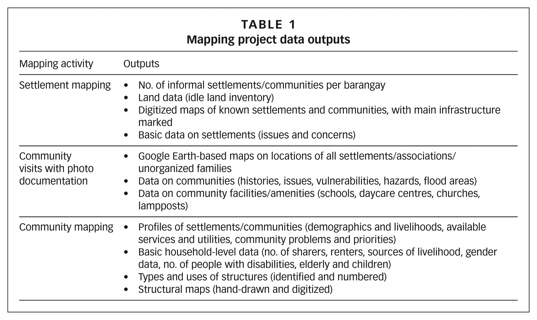
The mapping team, which includes the communities themselves, was tasked with collecting data on the informal settlements and using this information to create shelter plans at the barangay level and to develop projects for priority communities. The assessment stage of the planning process consists of 1) data gathering through the mapping and profiling of settlements and communities, and 2) analysis of data outputs. Data outputs relate to specific activities, to be carried out as shown in Table 1.
Mapping project data outputs
The local core mapping team puts all the data together to create assessments of the communities mapped. Essential to the analysis of each community are data on measures of community capacities such as organizational maturity, presence of community savings, livelihood sources, etc. Also crucial are data on measures of risks at the location, including natural or anthropogenic hazards and the legal status of land. All data outputs and assessments are validated in meetings and community assemblies. During these meetings and assemblies, community members themselves assess their own capacities and location hazards and risks based on agreed sets of criteria. Results of mapping and assessments will help communities identify their priorities around shelter and other development options during barangay-level shelter planning, carried out jointly by all city stakeholders.
The technical group, TAMPEI, is tasked with undertaking training sessions on mapping activities for the local key actors who will compose the local core mapping team, which includes members of the Urban Poor Alliance Muntinlupa and Bukluran, local HPFPI members, and a representative of the city’s local housing board. The team is trained on the use of GPS devices, profiling of communities through focus group discussions and interviews, surveys of households, and preparation of maps. The core team is also involved in conducting validation workshops, and helps facilitate data analysis and the planning activities of communities.
The local core team is expected to manage and facilitate activities on the ground at first, and later on to be able to form and train other local teams in the mapping process. In the actual mapping activities, community members themselves, during general assemblies, are asked to draw their own homes on base maps, carry out a household data survey, and write down the information on prepared data sheets. They also relate their own community histories, issues, concerns and aspirations through focus group discussions and informal interviews.
The active participation of communities from the mapping process up to the development of plans is critical to ensure that the output plans are responsive to their needs and priorities. No person or group knows or understands the situation of low-income households better than those families themselves.
The process of participation becomes a learning tool for the communities as they gradually begin to understand their situation, at first, simply by talking about their families and their communities. This is followed by chatting with neighbours during meetings and assemblies, and afterwards by attending validation workshops and planning activities to prioritize projects for their communities. At the same time, the communities’ confidence is built so that they learn to negotiate and build relations as they meet and work with people within their communities, in government, in various groups and organizations, and from other communities. The local government and development agencies involved in this project recognize that the participation of local actors, especially communities, means having an internally driven mapping process that is more likely to yield concrete data and assessments. This process can also be beneficial in terms of a community’s own internal relationships. For instance, in one settlement, Purok 4 in Barangay Sucat, a community divided by factionalism (having two presidents at the same time) decided to set aside its differences after members and officers realized (during the presentation of community capacities and location risks) that it would be advantageous for them to unite when negotiating with the landowner for the acquisition of the land they resided on.
c. Sustaining gains through savings
For the federation, the mapping process also serves as an entry point to the possible organizing of the communities, and orientations on savings groups have been included as a component of the mapping initiative, facilitated by HPFPI after mapping activities in an area. Savings groups are the core organizing tool for the federation, providing a platform for strong local women-led organizations, as these groups are able to respond to the communities’ needs and build their collective capacities (Photo 1). Saving helps to deepen the communities’ understanding of their realities and strengthens relations among members when they begin to get together and talk about their needs, find solutions collectively, and collaborate with government and other groups for their development.
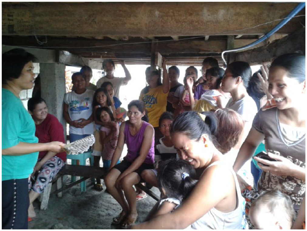
Savings orientation among residents of the West Kabulusan community in Barangay Cupang, Muntinlupa
Saving is also a strategy for addressing low-income families’ vulnerabilities to risks and calamities. Not only does it create a fund for household or emergency needs, but – when developed as community savings – it leverages external resources for securing tenure, upgrading facilities, and meeting other development requirements of the community.
The mapping activity in Muntinlupa City aimed to demonstrate the importance of involving communities in any city, regional or national development effort such as poverty alleviation, shelter provision or disaster intervention projects. An initiative that has involved communities in arriving at decisions and solutions, and that recommends community-driven strategies, will be more likely to prosper than one formulated without integrating ideas and experiences from the ground.
d. The city planning process
The Local Government Code of 1991 (or Republic Act 7160) mandates city and municipal governments to formulate a Comprehensive Land Use Plan (CLUP), which is the plan for the management of local territories.(12) There is also the Comprehensive Development Plan (CDP), a multi-year, multi-sectoral plan that “consolidates the programmes and projects” of different development sectors.(13) The CLUP is the long-term framework plan while the CDP is the medium-term plan. The creation of the CDP includes a consideration of the sectors of social development, economic development, infrastructure development, environment and natural resources, and institutional development. Housing as a social service forms part of the social development sector.(14) If a city or municipality has a local shelter plan, this is used as an input to the CDP(15) and CLUP.
As a policy, the government encourages broad, multi-stakeholder participation in the preparation of these plans and has established various platforms for the participation of city stakeholders in the development of the CLUP and CDP. Among these are the local development councils at the city or municipality and barangay levels, which actually lead in the formulation of the city’s CDP. These councils consist of city stakeholders, including representatives of local civil society.(16)
Meanwhile, the process of developing the city’s CLUP or long-term framework plan is assigned to the City Council and the city’s planning core group. Participating in this process are the technical working groups that assist the city’s planning core group; the technical working groups also include representatives from civil society groups.(17) In Muntinlupa City, the Muntinlupa Development Foundation, which is also a key member of the mapping initiative described here, sits in the technical working group for both the city’s local development council and CLUP.
The third platform set up by government is the local housing board, which was revived in Muntinlupa City when the incumbent mayor was re-elected in 2013.(18) These housing boards, like the local development councils, are special bodies in a city – established, in general, to formulate and monitor housing policies and act as a clearing house for eviction and demolition activities in the city. The local housing board membership consists of city officials and representatives from NGOs and people’s organizations.(19)
Finally, one other platform is the city/municipal Disaster Risk Reduction and Management Council (DRRMC), composed of members from among local officials, the private sector, and civil society groups. The council is tasked with developing, approving, monitoring and evaluating local DRRM plans.
While these platforms provide communities with opportunities to participate in the city planning and decision-making processes, some issues may arise with regard to city councils being able to properly deliberate on informal settlement concerns.
One issue is how these local bodies can satisfactorily discuss the concerns of communities without having concrete information on them – for instance, basic profiles of each community, what it really needs, common issues affecting particular settlements, and perhaps a blueprint for how the communities intend to respond to these issues. “Without the proper information on communities, output proposals or recommendations of councils may not be based on the actual needs of communities, just token projects that turn out to be supply- and not demand-driven”, said Ruby Papeleras, HPFPI Coordinator for the National Capital Region and a coordinator of the CDA (Citywide Development Approach) project in Muntinlupa City.
Another limitation of these special councils, according to Papeleras, is that, without a concrete, integrated plan of activities from the communities, patronage politics may come into play in council deliberations, resulting in some groups being favoured by political personalities or by the ruling political party. This situation results in resources of government “being improperly allocated or utilized to the detriment of the communities”, she said.
The initiative of the Muntinlupa City government to formulate its local shelter plan under the CDA project bodes well for the informal settlement communities in the city because it provides an opportunity for community members to participate in the plan creation via the mapping activity and initial shelter plan discussions at the barangay level.
e. Adding value to the planning and implementation of land use and shelter strategies
The recent mapping project in Muntinlupa City facilitated the city’s planning initiatives in many ways and contributed to more informed decisions by council members. It also encouraged genuine participation of communities in the process and promoted better relations among the city stakeholders (Photo 2).
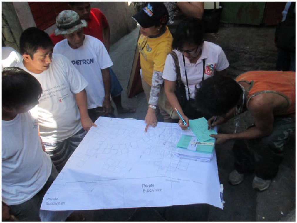
Community members in Sitio Pagkakaisa in Barangay Sucat locate/draw their homes on a base map
One way the mapping activity added value to city plans is in the type and quality of information it generated and the process by which this information was gathered. In the mapped settlements, the activity was able to generate information on the following:
Household demographics, including the number of families, vulnerable members, types of employment, and educational levels of family members
Housing, such as the number of structures, types of materials used for housing, and uses of structures
Services and amenities that households/communities are able to access, including power, water and sanitation
Community or settlement profiles, including issues and concerns of communities
Hand-drawn and digitized maps to determine community boundaries, community resources, amenities and infrastructure
Hazards and risks that communities face due to natural and human-induced disasters
Community capacity and readiness, and assessment of the locations (physical and legal status) by the communities themselves
For project development, preliminary inventory of land available within the city for informal settlement communities
Based on this information, a more or less concrete and detailed profile can be generated for each informal community in the areas mapped, which can serve as a guide and basis for action in determining and addressing the real needs of communities, as well as identifying prospects for upgrading and other initiatives. Related to this, the information generated will support the creation of plans and proposals from communities that ensure better use of government resources, because budget allocations will be based on the actual requirements of communities and not on assumptions about people’s needs.
An added value of the mapping activity is the participation of communities in the actual gathering of information (Photos 3A and 3B). This is important because through the mapping process the communities become more aware of their own situation and can judiciously decide on their own futures based on concrete information generated by the mapping activity. When community members sit and participate in the special bodies, they are better able to articulate their concerns, having a more complete picture of the situation of informal settler families at different levels: household, settlement or barangay.
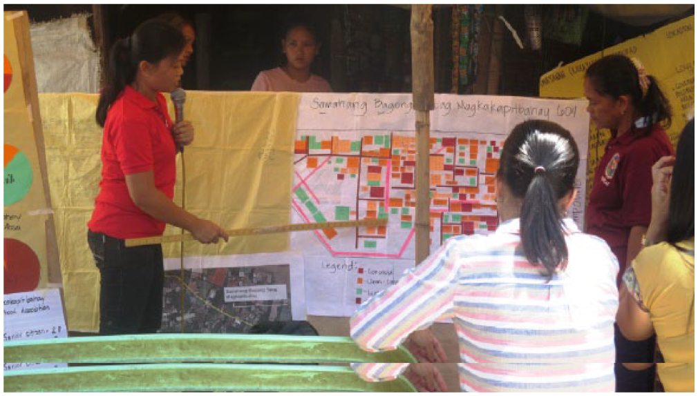
Residents of Samahang Bagong Tatag Magkakapitbahay 604 in Purok 6, Barangay Putatan, Muntinlupa City present the maps they prepared for validation
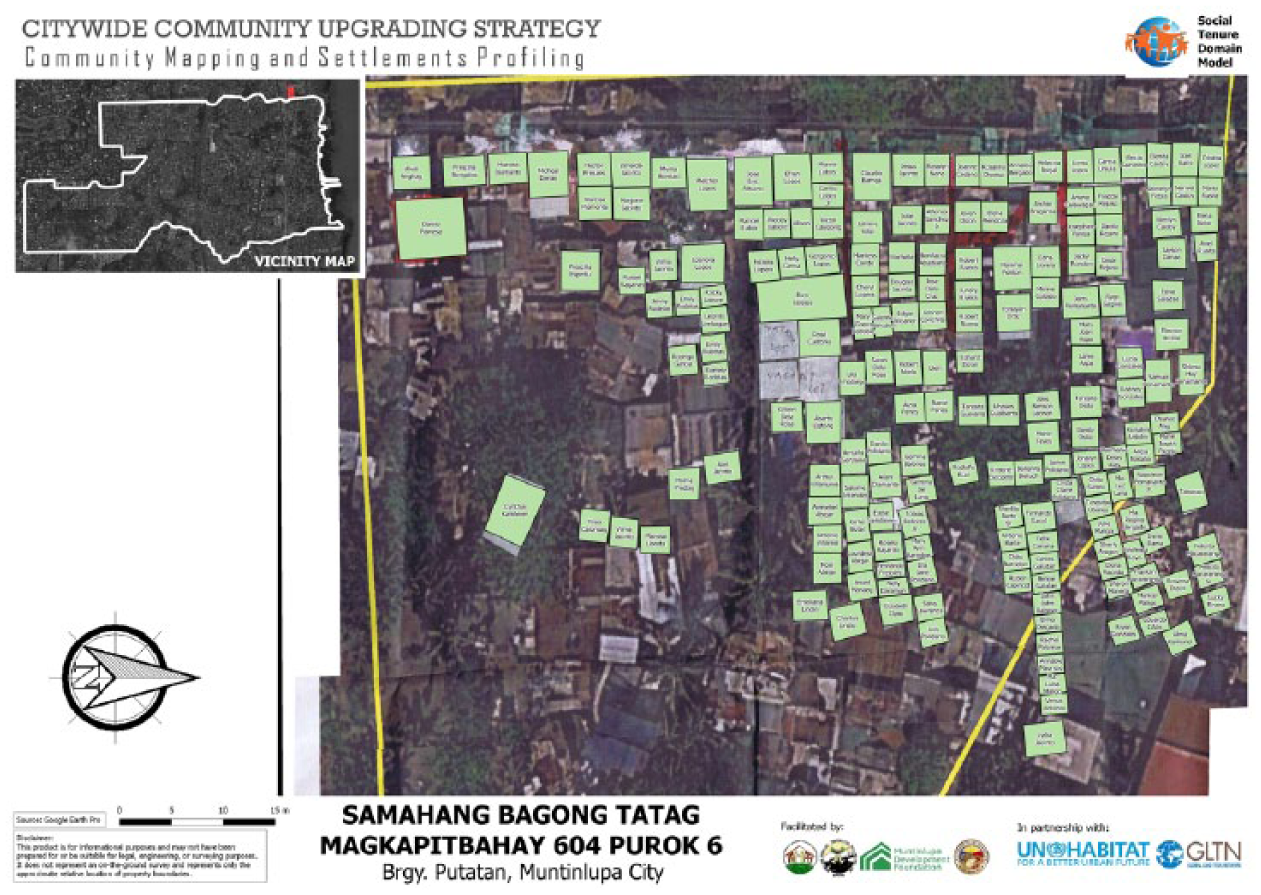
Digitized map of Samahang Bagong Tatag Magkakapitbahay 604 in Purok 6, Barangay Putatan, Muntinlupa City
Also, the mapping information actually helps other members of special bodies to understand communities better and to make more sensible decisions on different shelter concerns. Nestor Villanueva, who, for two terms, had been a member of the local housing board focusing on informal settler families in private lands, said, “I was groping in the dark before information from the mapping activity and profiles of informal settler families became available.” Since he is also an active member of the mapping team, the process greatly helped Villanueva to get to know the communities well and enabled him to provide concrete responses to queries on the status of informal settlement families.
The mapping activities in each barangay culminated in a participatory barangay planning activity in which a network was formally established to facilitate communication within and among the different mapped communities, the barangay government and city government. Focal persons from different settlements were strategically chosen to represent the different communities in barangay meetings and ensure that they were able to bring their concerns to the table. Even when they did not sit in the special bodies, communities could still directly correspond with the barangay chair to give and receive updates on issues affecting them.
Once they are able to develop their own People’s Plans, with details of their intended shelter project and its management, the communities can negotiate directly not only with local governments but also with national housing agencies such as the Social Housing Finance Corporation. By creating their own plans based on the mapping information, communities can also get different stakeholders to sit at the same table and discuss the pooling of resources for communities’ initiatives. This process contributes to better coordination between the local government unit and different national agencies and more synchronized delivery of projects.
Moreover, the mapping activity can enhance the city’s DRRM plan since the gathered information, which includes data on identified hazards and risks in specific communities or locations and the subsequent vulnerability assessments by the residents themselves, can help the city develop more proactive ways of responding to disasters.
The mapping initiative hinged on the belief that appropriate solutions to the shelter issues in Muntinlupa City should involve those concerned or most affected. More participatory approaches to the city’s planning processes ensure that solutions are based not on guesswork but on concrete needs. Participatory planning approaches also engender awareness and sharing of information that facilitate decision making by city stakeholders, especially between the communities and local government. Also, they strengthen capacities of the stakeholders, particularly the communities that are now able to articulate their situation and concerns because of the information they wield. Lastly, participatory approaches build and sustain partnerships among stakeholders. Through regular dialogues, workshops and coordination meetings to update each other on activities, stakeholders share and validate information or reflect on experiences encountered and lessons learned, gradually developing trust among themselves that may lead, hopefully, to better plans for the city.
The mapping in Muntinlupa City aimed to gather data on the situation of informal settlements in the city and feed this information into the city’s shelter plan and land use plan. But while it was participated in and supported by a number of stakeholders, including the national and local governments, the World Bank, civil society organizations and informal settlement communities themselves, it was not an easy process of collaboration, as explained below. Some segments of the urban poor for instance were sceptical about the process because surveys and censuses had also been made in the past but did not really help improve their situation. Even so, HPFPI put all its efforts into the initiative, seeing it not simply as a forum for the planning and upgrading of informal communities but also as a process that could bring about change in people – and especially in the relations between communities and the government, and in their ways of thinking and doing things. There is a hope that the urban poor communities in Muntinlupa will continue to participate in the mapping, contribute to the land and shelter planning of their city, and eventually be recognized as legitimate partners of the city in development.
When the mapping team of NGOs, people’s organizations and community volunteers first introduced the activity in the communities, it generated mixed reactions from community members. “The people were perplexed; some were questioning and others felt afraid that their homes might be demolished when we visited their communities”, said Elenita Flores, a community member who volunteered to become part of the core mapping team. Some thought at first that they would be evicted and refused to cooperate and participate in the activity. The mapping team needed to visit the communities many times until it understood what the mapping activity was all about. Other community members, meanwhile, thought that the activity was part of an election campaign for a politician. Still others thought that help had finally come and they would finally be given land.
The team had to explain that the mapping activity was intended to gather information about the communities – that it was not part of any election campaign activity, and did not carry any threat of eviction or the promise of benefit, such as land or housing. They explained that the only guaranteed benefit was that, once the mapping was completed with the communities’ participation, they would be able to use the information generated to negotiate with the government and other stakeholders.
An even bigger challenge for the mapping team was getting the full support of local authorities for the activity during the first few months of the mapping. While some government officials and staff were most accommodating to the team, others were indifferent, or even had reservations about the ongoing activity. Initially, some even questioned why the mapping activity needed to be undertaken, when the government was already marking the locations of informal settler families. This reaction is indicative of the government’s lack of openness and its propensity for top-down planning and decision making, with little involvement from other stakeholders, especially the communities.
When the project was completed after a year, the communities’ attitude changed. The communities and the mapping team presented the results of the mapping activities to the city stakeholders, especially the barangay and city governments, which clearly appreciated the information. Chair Mamerto Sevilla of Barangay Sucat said that the “data on ISFs [information on informal settlement families] will definitely help the government in providing the needs of the people”. And, referring to the maps generated, he said, “We know now where our fire trucks will pass through should there be an emergency.” Indeed, with the information gathered from the mapping activity, five land acquisition projects have been started in this barangay, and the five communities are now being prepared for the CMP in collaboration with the national government’s Social Housing Finance Corporation and the city government.
This outcome has also contributed to establishing trust between communities and the local government. Community members of the networks, or the so-called “technical working groups” formed in each of the barangays that were mapped, openly discuss and engage in healthy debates with their respective barangays and with city officials during meetings.
The success of the mapping activity also opened doors for the continuation of the mapping activities in the other four barangays in District 1 – Bayanan, Tunasan, Poblacion and Putatan. These were jointly supported by the city government of Muntinlupa, UN-Habitat, and the Global Land Tool Network under the Social Tenure Domain Model Project, which seeks to generate a citywide profile of all informal settlement families in Muntinlupa.
III. Mapping in The Cities of Valenzuela, Manila, Davao and Iloilo
The mapping initiative in Muntinlupa City is just one of those in which HPFPI and the rest of the Philippine Alliance institutions were involved in 2015. Mapping activities in which the Alliance plays a key role are also taking place in other areas such as Valenzuela City, Intramuros in Manila, Davao City and Iloilo City. While the depth and scale of mapping activities in these areas vary, the federation employs the same community-driven approach and faces experiences and challenges more or less similar to those encountered in Muntinlupa City.
a. Valenzuela City
The Valenzuela People’s Network or VALPONET, an alliance of about 13 urban poor communities, led the implementation of the settlement mapping and profiling in 16 barangays (out of 33) in the city in 2015. The mapping activity, facilitated by HPFPI and the TAMPEI and supported by SDI,(20) is part of VALPONET’s effort to gather data on the situations of informal settler families to determine their specific needs and advocate for their inclusion in the shelter plans of the covered barangays.
The 2015 mapping in the city is a follow-up of mapping activities in 12 communities in two barangays carried out the previous year. A barangay planning activity was held after the mapping in Barangay Mapulang Lupa, and this experience led to the opportunity for HPFPI to partner with the World Bank for the Muntinlupa City mapping.
Community leaders and VALPONET volunteers trained with HPFPI and TAMPEI on the use of GPS and the conduct of interviews and focus group discussions, with the aim of gathering these individuals into the core mapping team. This core team’s main duty is to teach other communities the various mapping activities. “I had a good experience doing settlement profiling and mapping”, said Erlinda Mosqueda, President of VALPONET. “I learned how to use the GPS device. I want other leaders to learn as well how to interview using the settlement profiling form. I am happy that with this mapping activity more community leaders have learned how to interview and fill out the form.”
In Valenzuela City, specific activities included mapping of boundaries of settlements or communities, mapping of amenities and infrastructure, and profiling of settlements. The mapping team deferred carrying out the structural mapping and household surveys, especially those in moderate risk locations, because it intended to organize and strengthen the communities to prepare them well for possible project development. Following the mapping of the communities and settlements, HPFPI conducted savings orientations for communities that were ready to organize.
Similar to Muntinlupa City’s experience, VALPONET faced many challenges, among which was convincing communities to participate in the mapping. “One community refused to participate and give out information about their area for fear that the data gathered might be used against them”, said Mosqueda. Despite hearing a number of times an explanation of the purpose of the mapping, several communities still refused to participate.
The Alliance is keen to support the mapping initiative in the city because it wants to make sure that the communities are able to get hold of concrete data on informal settlements and prepare them for negotiations with local authorities – particularly the city government, which is currently implementing a number of government-initiated social housing projects. This is what VALPONET also has in mind. “The important thing about doing the settlement profiling and mapping is when one community asks for their own data, VALPONET is ready to give them”, said Mosqueda.
b. Intramuros, Manila
Early in 2015, the Intramuros Administration (IA) explored partnering with the Philippine Alliance team of HPFPI, TAMPEI, PACSII and LinkBuild to address the shelter and development concerns of nine informal settlements in vacant lots within the national heritage site of Intramuros, or the “Walled City” in Manila, which covers four barangays. There has not been any systematic attempt to understand the situations of the informal settler families in this area. No baseline information is available on the physical, socioeconomic and tenure situation and on how upgrading in the informal settlement communities should be undertaken.(21) The Philippine Alliance agreed to facilitate the mapping and profiling of the informal settlement communities with the IA as the coordinating body. The Philippine Business for Social Progress, which was brought in by IA, extended technical assistance for the project.
Mapping activities on the site started in April 2015 with members of informal settlements taking the lead in the various mapping processes, such as the settlement and structural mapping. Since there was no local organized community to facilitate the focus group discussions for the settlement profiling and interviews for household surveys, HPFPI and TAMPEI, with the help of architecture student interns, at first took on these tasks with the intent of later training core leaders of communities within the area.
The Intramuros mapping faced a number of challenges in its implementation. First was the reluctance of the communities in the beginning to participate because of their past experiences with previous administrations of Intramuros, which had harassed them or duped them into participating in surveys that were later used as a basis for evicting them. The mapping team had to explain carefully to the communities that the mapping was intended to gather data that the communities could use to negotiate with the IA and government agencies.
The second challenge was that the authorities in the four barangays within which the nine settlements were located refused to cooperate and support the activity, afraid to change the status quo that protected their political and/or business interests. The barangay officials dismissed the current IA administrator’s call for support, and the efforts of the mapping team to persuade the city officials of Manila to intervene and convince the uncooperative barangays came to naught. As a result, the team was only able to map two of the nine settlements in the area, with only one barangay participating in the activity, out of the targeted four within the IA jurisdiction.
Despite having been able to map only two settlements/communities, the information gathered by the team was enough for stakeholders to convene and discuss shelter options in a public forum. This was held during the Community Architects’ Network (CAN) Regional Workshop in June 2015 in Manila, which used the occasion of the mapping activity in Intramuros as an opportunity for learning and for extending support to other community initiatives by CAN delegates from different countries in Asia and other parts of the world. The forum was attended by key national government agencies, especially the Social Housing Finance Corporation and the Philippine Commission for the Urban Poor. Several proposed shelter options were developed by the team:(22) 1) onsite upgrading for the nine settlements/communities; 2) mixed-use development of IA properties; and 3) relocation to abandoned buildings and other nearby (in-city) locations. Under option 1, a schematic shelter plan was further developed for the one community (Banana Island) that went through the mapping process and whose members formally established their organization with the support of HPFPI.
The mapping results and the forum brought to light the situation of the Intramuros communities for the first time, setting off a dialogue between the communities and other urban stakeholders. Weeks after the forum, the Department of the Interior and Local Government reported the availability of funds to address the shelter needs of the Banana Island community in Intramuros. However, the funds can only be used for an off-site relocation project by the community.
Although dismayed by the government’s restrictions on the use of funds, HPFPI believes that the mapping initiative in Intramuros was a significant event for the participating communities. By locating their own homes (through hand-drawn maps) and relating their community histories, the communities gained a deeper understanding of their strengths and capacities. “The mapping succeeded in raising awareness among the community members which is the first step towards getting them to act on their situation”, says Ruby Papeleras, HPFPI National Capital Region Coordinator.
c. Davao City
In November 2014, the local government of Barangay Ilang in Davao City asked for the assistance of HPFPI in its plan to relocate about 2,000 informal settlement families living along the coastline within the barangay. The area has been identified by government as a high-risk area. HPFPI suggested that they first carry out mapping to determine the families’ actual situation and needs. Training sessions on mapping were conducted and participated in by HPFPI in Davao, TAMPEI architects, student interns, and a number of leaders from the five zones or purok in the settlement. The participants were taught the use of GPS devices for mapping boundaries, community infrastructure and resources. They were also taught how to conduct interviews and focus group discussions in the profiling of settlements and household surveys.
While most families were very cooperative, the mapping activity in the settlement was not without its challenges. As in the other cities carrying out mapping initiatives, some community members hesitated to participate for fear of being evicted and losing their homes and livelihoods. The families nearest to the shore had been the most resistant, explaining that they were fishers and had to live near the sea. A community association in Zone 3-B refused to participate altogether because it reasoned that the previous administration had already issued a presidential proclamation declaring the settlement a site for social housing. The association said that it had a list of all its 200 members and thus the area they occupied did not need to be mapped. Years earlier, the community had submitted a proposal, for shelter development of the area, to the barangay. But this was rejected because it did not conform to the requirements of the building code for social housing.(23)
A planning meeting was held in August 2015 to present the preliminary mapping results to the communities and the barangay. Representatives from the city planning office and from national agencies, such as the Department of Public Works and Highways, Housing and Urban Development Coordinating Council (HUDCC), Presidential Commission for the Urban Poor and Housing (PCUP), and Housing and Land Use Regulatory Board, also attended the meeting. This became the occasion for a dialogue among the informal settler families (including the president of the registered association), barangay, and government agencies to clarify issues and discuss development options for the settlement. Following the meeting, the local inter-agency committee, which was chaired by the city mayor, was convened to further discuss and work on the issues raised during the planning, including the identified hazards in the settlement and the impact of the government’s road development project, which may result in some families being relocated, among other concerns.
Attaining security of tenure for the informal settler families in this coastal community still entails a lot of hard work. But Janeth Mandin, Coordinator of HPFPI Southern Mindanao, remains hopeful. “The results of the mapping activity have been positive”, she said. “Even the representatives from the national agencies, especially HUDCC, highly appreciate the conduct of the participatory mapping which was able to generate information on the actual situation of families.” It is hoped that the process of collaboration, which was started by the participatory mapping, will encourage more dialogue and discussions of key issues between the community and government, contributing to and perhaps hastening the achievement of this goal.
d. Iloilo City
HPFPI in Iloilo City has a long history of strong collaboration with the city government, beginning with the creation in 2005 of the Iloilo City Urban Poor Network, which consists of three urban poor federations, including HPFPI. This partnership has afforded HPFPI and PACSII the chance to participate in various technical working groups and planning bodies to formulate guidelines on the government’s programmes, such as its social housing programme, resettlement and monitoring, housing and basic services provision. The Philippine Alliance provided inputs and recommendations on the 2012 Comprehensive Land Use Plan (CLUP) of the city, as well as taking part in the formulation of the city shelter plan based on the recommendations proposed by the urban poor network.
The Alliance in Iloilo City takes a proactive stance in its participation in city planning by way of undertaking mapping activities in various informal settlement areas. The mapping team in Iloilo consisted of HPFPI volunteers, TAMPEI technical professionals and interns, and community leaders doing settlement profiling and mapping and counting of structures. As of November 2015, the team has mapped, profiled and enumerated structures in nine settlements in five city districts.
The mapping team in Iloilo reported encountering several challenges, including dealing with uncooperative barangay authorities and community leaders and the sceptical attitudes of residents towards the team. The team emphasized that it is important to make courtesy calls to the authorities before conducting mapping activities. During these courtesy calls, the team can request guides to the relevant communities. Participation of communities and local government, from the purok level up to the city, facilitates the mapping activity because, among many other reasons, it builds the trust that allows them to engage in the process.
IV. Conclusions: Some Lessons Learned in Community Mapping
In the mapping of informal settlements in different cities, HPFPI may seem to be following the same pattern of activities each time. But the kind of mapping that it does is actually specific to each particular area. “We do not follow any single model because the situation of informal settlements and our engagement with local government units differ in each mapping area”, said Papeleras. “Moreover, our mapping activities are still evolving and as we proceed to the next area, we learn new things from all those involved in the mapping, but especially from the people.” However, the federation does face similar issues and challenges across cities while carrying out mapping.
Informal settlement communities visited by the mapping teams have typically been guarded when approached to participate in mapping activities. Their informal tenure status and the unpleasant treatment of the communities by local authorities in the past have engendered distrust among the residents towards anyone who asks for information about them. One can only be patient in explaining the purpose of the mapping. It is tempting to make promises of a “better life” for the residents to get their cooperation. But the communities must understand that the mapping of their areas does not guarantee land or housing – it only guarantees information that they can use to lobby for their agenda with government and other stakeholders. This lets them decide on their own and think of solutions for themselves.
This said, it is important to get the informal settlement communities to participate in the actual mapping. While it is easy to let the architects or student interns use the GPS devices and administer the interviews, the “end goal should be to let the community leaders handle, manage and conduct the profiling and mapping by themselves”, according to the Iloilo mapping team. Community mapping is an effective way for the people to learn not just about maps and doing interviews but about their communities and the issues that affect them. The process allows them to connect with other members and other communities, bringing them together to talk about their concerns, develop solidarity and act on their situation.
At the same time, the participation of local government units is needed to facilitate the mapping because their presence validates the activity. Government collaboration in the mapping gives credence not only to the process that involves the community but also to the results, once they are presented to the barangay and city officials, including the city councillors. The barangay officials are also obliged to formally call on the communities to participate, and residents can ask government for support in the mapping activities, such as the photocopying of survey forms. Also, for the community general assemblies, the barangay government can facilitate the provision of the place (usually a multi-purpose hall or basketball court) for the activity. When mapping team members go visit the areas, government provides vehicles or transportation fares or sends personnel with the team as area guides.
More important, when the government participates, it has to share the information it has on the communities, attend coordination meetings where it can learn more about the communities, contribute to enhancing the mapping outputs, and facilitate the resolution of issues that need to be addressed immediately. In relation to this, the federation hopes to get from government not just token gestures of support but the establishment of community mapping as part of the cities’ planning processes, which often fail to determine and consider the needs of the informal settlement communities.