
Abstract
This paper examines the role that community architects and other professionals can play in helping urban poor communities to survey and map their living conditions and draw up comprehensive site plans for upgrading or relocation projects. The mapping process can lead not only to a physical map but also to dialogue and understanding between community residents about the place they call home and how it relates to the wider environment, which will feed into the planning process. In addition, all the communities within a city may join together to carry out citywide mapping of informal settlements, effectively putting themselves on the map and on the local authorities’ agenda. Throughout these stages of mapping, the role of the professional is to facilitate the processes technically, as well as to ask the right questions of the community members so as to encourage them towards a deeper understanding of their socio-political and physical living context, and to take the lead in developing solutions.
I. Introduction
Urban poor communities are increasingly able to take control of their housing choices, from negotiating land leases or buying land, contributing financially through savings groups and implementing infrastructural and housing improvements. These actions are often undertaken as a collective, such as those supported by the Asian Coalition for Community Action (ACCA) programme (Box 1) of the Asian Coalition for Housing Rights (ACHR). However, these proactive community members may sometimes need a helping hand in the form of technical assistance, and community architects can play a vital role in enabling communities as they work towards a more secure urban future.

The ACCA programme supports a process of citywide upgrading – that is, seeing slum communities not in isolation but as a collective, with all slums forming part of the city’s anatomy and which therefore have to be looked at in the wider context of the city’s form. For this purpose, the process of citywide mapping can be a vital tool in gaining an understanding of housing problems within a city and in prioritizing settlements for the process of upgrading when there are limited funds available. Once citywide mapping has been completed and comprehensive data have been collected on the number of communities, their land tenure status, the housing problems they face, the number of residents, their incomes and any other relevant information, this information can be shared with city authorities. This is often the most comprehensive data that city authorities will have on low-income settlements within their city, and the process of collecting and collating this data empowers the city’s poor, as it gives them informational advantage – a bargaining tool.
However, equally important as the process of citywide mapping is that of community mapping – which allows the residents of a community to understand not only the existing situation within their community but also how their community relates to the wider environment surrounding it. Following the mapping process comes comprehensive site planning for the long-term future of the community’s development. This paper will examine the role and function of citywide mapping and then focus on community mapping and site planning, providing case studies to demonstrate how it is implemented and how communities can benefit from the process. With the right kind of input from architects or other professionals, who are playing a dual role as they also act as community development workers, the process of upgrading to secure housing will extend far beyond simply physical improvements to housing. The paper first outlines the various stages involved in the mapping process,(1) as well as the process of comprehensive site planning that follows(2) and gives examples from Burma (Myanmar), Bangladesh and Fiji, among other countries.
II. Why is a people’s process necessary?
The alternative to a people’s process for addressing housing issues is a top-down solution with no real input by those who will be affected. Without this input, the providers of housing solutions may act with no real understanding of the way of life of the community residents, of their relationships with each other and also their relationship with their wider environment, from natural resources to their cultural heritage. If no effort is made to understand and take into account the overall context of people’s living environment, then housing solutions are unlikely to meet their needs fully.
The mapping process is also an important learning process for community members, as it helps them to identify and analyze various issues – such as the key problems that they face and how to prioritize problem solving – as well as assessing the resources they have to hand, be they natural, social, cultural or economic. By gathering all the collected information into a database, the residents can create a valuable tool for planning purposes, having to hand the necessary information about financial resources, skills base, disaster risks and infrastructure needs, among other things. Mapping is a process, with an aim that goes beyond making a piece of paper with lines on it. The success of mapping need not be measured solely by the production of a physical map; if the process leads to a common understanding and increased dialogue by community members about their relationship to their living space and their community’s relationship to the wider environment, then this also is an indicator of success.
The mapping process also plays a very important role in putting the urban poor communities “on the map” within the wider context of the city in which they are located. Very often, urban poor communities are an invisible or neglected part of the city. They are ignored in city plans and overruled by commercial developers. When the poor communities within a city gather together to organize themselves in order to carry out surveys, they can form a network of people facing common issues and can negotiate collectively for their future through their strength in numbers.
III. Citywide Mapping in Practice
The key to the mapping process is that it should be carried out by the residents themselves, be they young or old, male or female. Actively participating in the mapping process gives the residents a deeper understanding of their community context. It is also an opportunity to identify key problems and existing resources and how the community can address these problems and make use of the resources, addressing not only their housing situation but also their economic and social conditions.
Mapping can take place at different levels: geographical, city, community, household and issue based. Geographical mapping identifies natural features and can be particularly relevant for communities at risk of natural disasters, such as those located on coastlines or near volcanoes, and also for communities close to natural resources such as forests and streams, so that these threats or resources can be accounted for in future planning.
Citywide surveying is very important in cities with multiple low-income communities facing housing or land tenure problems. The process of surveying can bring all these communities into contact with each other and lead to the formation of a network that can negotiate collectively for housing solutions for all of the city’s urban poor, as identified in the mapping process. Citywide mapping not only pinpoints the location of all informal settlements but also highlights the different types of tenure and the different landowners, as well as the common problems facing communities; it also identifies areas of vacant land that could possibly be leased or purchased by those communities needing to relocate for upgrading.
In the city of Bharatpur, Nepal, the citywide mapping process identified 54 settlements, of which 19 were located on the edge of a national park where there was space for them to squat and where they could obtain resources such as timber for firewood. As there were pre-existing tensions between the squatters and the national park officials, identifying all the communities in this situation enabled them to group together to collectively negotiate an agreeable solution with the authorities, to remain on site and use forest resources sustainably. In some cases, the forestry authorities even provided some timber for construction. As demonstrated in this case, citywide mapping can provide a focus and direction for upgrading activities.
The municipality assisted the process by preparing a city profile and a city map on which informal settlements were plotted (Photo 1). Eight community representatives from each community, both men and women who had good knowledge of their own community and its amenities and features, were invited to join in the participatory citywide mapping process in order to plot these on the map. They then each presented their own community to other gathered communities, sharing their common problems and potential for future development. This information was then all entered into an informal city level database. As a result of these activities, a committee of the Slum Upgrading Forum was established, bringing together community networks and government representatives to work together on upgrading.
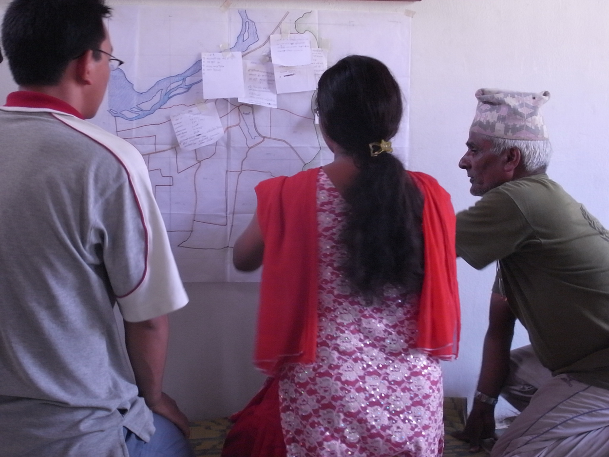
A citywide map of settlements in Bharatpur, Nepal is discussed among community representatives
In Moratuwa, near Colombo in Sri Lanka, women members of the Women’s Bank embarked on a citywide survey of the poor settlements in their city, carrying out the survey themselves. They were trained by the local NGO Sevanatha to do the survey, to read maps and satellite images obtained online, and to quickly assess the various poverty indicators in the slum settlements according to a “scorecard” system. The process allowed them to identify a number of poor squatter communities that had previously been ignored by government authorities and development agencies. Once these communities had been identified, their members were able to learn about the Women’s Bank and join in savings processes, and eventually to apply for loans and grants to upgrade community infrastructure and houses. The survey also identified and mapped plots of vacant land in the city, which disproved claims that there was no land available to house the poor. The women and Sevanatha then shared all this information in a meeting with the mayor and the municipality, and with their informational advantage, the women’s network was in a strong bargaining position. The next stage was to start savings groups in the newly identified communities and develop a citywide plan for upgrading, prioritizing the most needy slums as identified in the survey.
In the city of Lautoka, Fiji, satellite images from Google Earth were used to overlay maps of the individual settlements, distinguishing between those on state land and those on native land. This satellite imagery helped to pinpoint existing infrastructure and that which was lacking or degraded. It also made it possible to identify areas of vacant land that could serve as possible relocation sites. All of this information was compiled onto one large map that was presented to the Lands Department (Photo 2). This city map functions as a sort of “virtual” land bank with regard to vacant land. In conjunction with the city map, the community members also carried out “people mapping”, identifying key skills of community residents that could be useful during upgrading, such as carpentry, masonry and mat weaving.
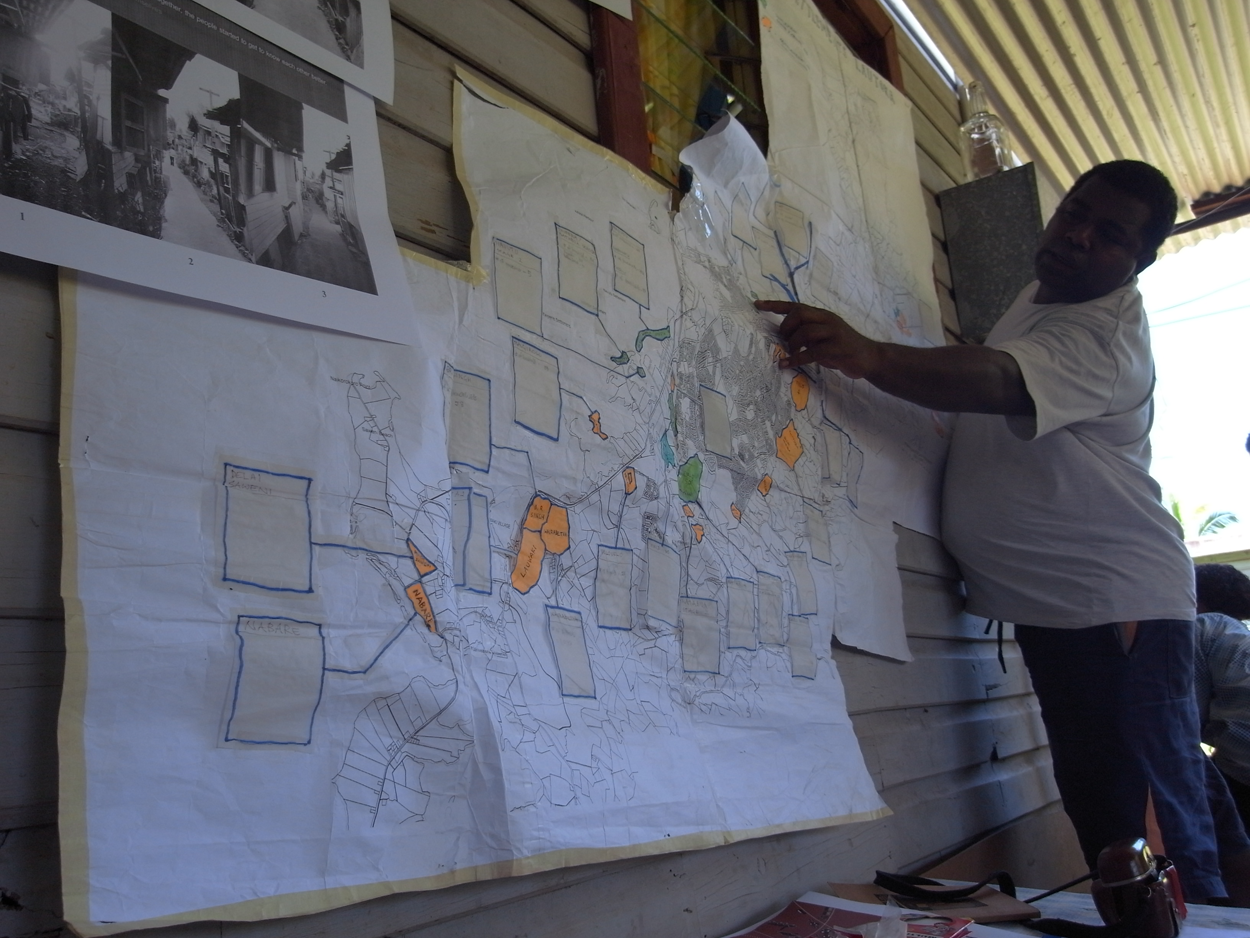
A citywide survey of the settlements and vacant land in the city of Lautoka, Fiji was compiled onto a large map and presented to the Lands Department
This process and the interaction with local officials are important not only in terms of bringing the various communities together but also in demonstrating to officials the communities’ intentions to move ahead with their plans. By being one step ahead of officials in terms of having accurate data about the number and state of informal settlements within the city, and possible relocation sites if necessary, they facilitate the local authorities’ job by effectively doing their work for them.
IV. Community Mapping
Alongside the citywide mapping process, it is useful for each community to carry out its own mapping process, documenting the community’s physical situation as well as surrounding resources, whether natural or infrastructural, to provide the context for the next stage of planning. The community mapping process can be kick-started by a “walking tour” of the settlement in small groups, taking notes and trying to view their community from a holistic perspective, not only as insiders but also from the viewpoint of outsiders.
The next stage is to draw the community map. This need not be a technical drawing but simply a representation of the community’s environment as perceived by the residents, including all houses and key features. If the community is large, the mappers can be split into smaller groups and then the overall community map can be pieced together from the smaller maps. Colour coding can be used to identify different buildings and spaces, such as houses, kitchens, toilets, pig sheds, vegetable gardens, pathways and plot boundaries. The completed map will then form the basis of community-wide discussions about the features and problems they have identified. The mapping process is about more than just the physical features of the community – when explaining what has been mapped, the opportunity emerges for stories relating to the community and its history: which areas were settled first, which houses were rebuilt following a fire, how the community’s shape has changed (Photos 3 and 4). These events over time have all shaped the community’s form and structure and affected the relationships of the people living within the community, and therefore should be borne in mind when considering its future.
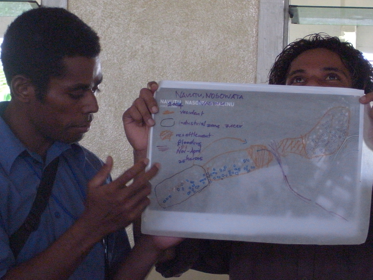
Community representatives in Lautoka, Fiji explain features of their community and how it has been shaped over time
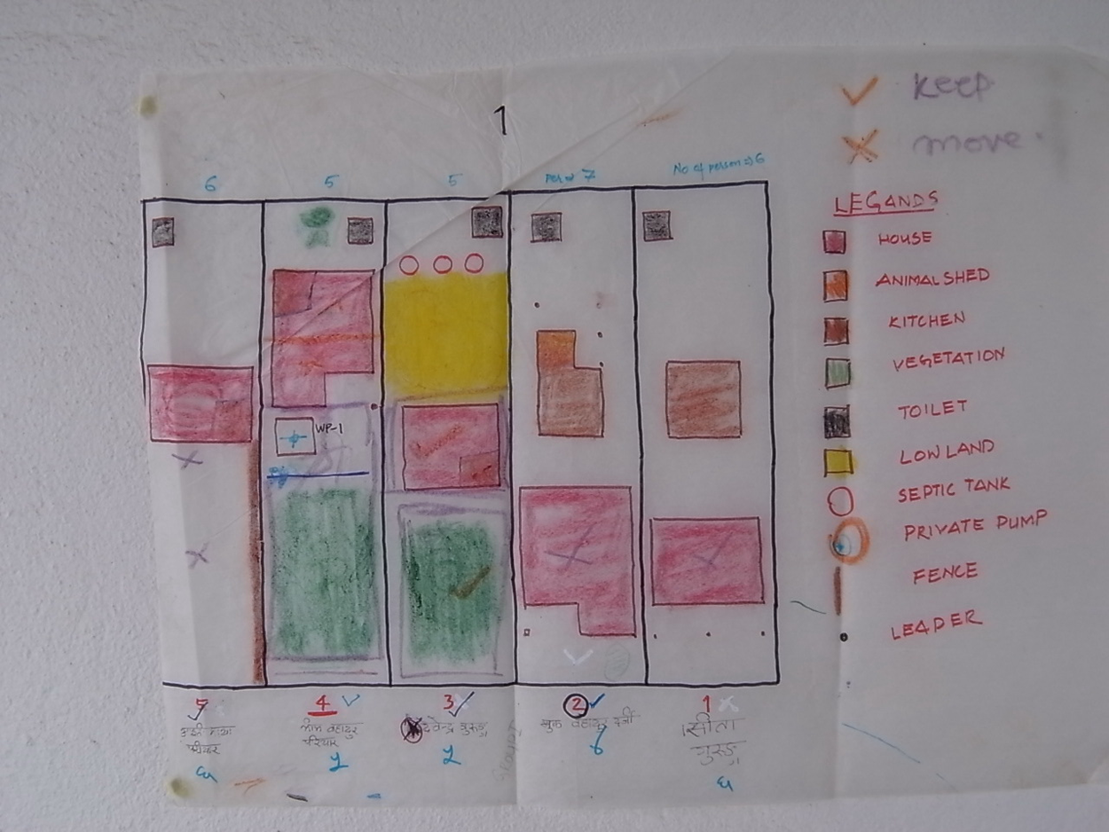
The map shows how each family allocates their land use and how they prioritize the various elements of a house in terms of which features should be retained – Bharatpur, Nepal
From the basic community-drawn map, professionals can help the community to draw a scaled map for use in the planning stage. Community residents can assist in measuring the community’s dimensions – this can be a role for the community youth. Architects can also help translate ideas into designs and diagrams that are technically accurate and that can be used for construction plans or to apply for building permission where necessary.
Maps are not final – they can be added to and changed as the community’s situation and surroundings change, to reflect the reality they are in. There is no perfect map, and the process of mapping can lead to dialogue about why a particular aspect was represented in one way and not another, ultimately leading to a deeper understanding of the community’s situation and how it is perceived by residents.
The process of community mapping is different when the community is relocating to a new site; they need to develop a relationship and understanding of their new location while retaining the values that matter to them from their old one. A mapping process in their current community can help identify household clusters and common problems that could be addressed in the relocation. This, as well as collecting data on existing house sizes and plots and the number needing to relocate, will help them decide on a suitable relocation site. The new site may house families from a number of different communities and therefore community network meetings should take place regularly, and possible relocation sites can be chosen from the previously completed citywide map.
V. From Mapping to Comprehensive Site Planning
Once citywide mapping has been completed, and the communities prioritized for upgrading on site or through relocation, with complete community maps, then it is possible to move onto the stage of planning the upgraded community. The community map will have helped the community to visualize and understand their current living conditions, including identifying natural or other resources as well as highlighting potential threats that need to be taken into account in planning the new or improved community. Figure 1 highlights the various stages of comprehensive site planning, both physical and socio-political, from mapping to construction.
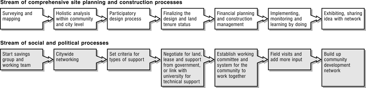
Diagram highlighting the various stages of comprehensive site planning, both physical and socio-political, from mapping to construction
The planning stage must consider the size of the plot on which reconstruction or upgrading, or construction in the case of relocation, will take place. When the size of the plot and the number of households is known, this allows an average individual plot size to be determined. However, it is likely that the community residents will want to leave space for communal facilities, not only roads or lanes but perhaps also a playground, a community centre or another type of public space. Thus, it is useful to hold a “dream community” exercise, in which all communities visualize their ideal community and the facilities it would have. This activity will highlight the facilities that are most important to the community members, be it a children’s playground or a market space, and these will then be discussed in terms of how much space should be allocated to them. Once this has been agreed, the remaining land space can be divided up between the households to determine each individual plot size. The community also needs to agree collectively on whether everyone should have the same size plot or whether to set criteria based on household size or other relevant factors. In order for people to get a better sense of dimensions, it can help to measure plots out in life size, using whatever tools are to hand, such as rope or floor tiles. People may readjust their size expectations once they see how big (or small) the space is in reality.
At this stage it is helpful to carry out another visualization exercise for “dream houses”, whereby everyone draws their dream house and then explains its features and why they are important (Photo 5). Models of these houses can then be built for better visualization (Photo 6), and this creates another opportunity for group discussion about why certain features are necessary and what infrastructure is needed. This then leads on to discussions about costs and how they can be kept low, which also relates to the layout of the community in terms of sharing facilities (Photo 7). The residents can also consider what materials they already have that could be re-used and what construction skills exist among community residents that could be used for self-construction. When costs and feasibility have been considered, the house size may be reassessed.
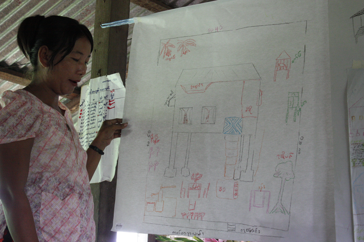
A community member in Ale Yaw ward near Rangoon, Myanmar presents her “dream house” and explains its features and why they are important to her
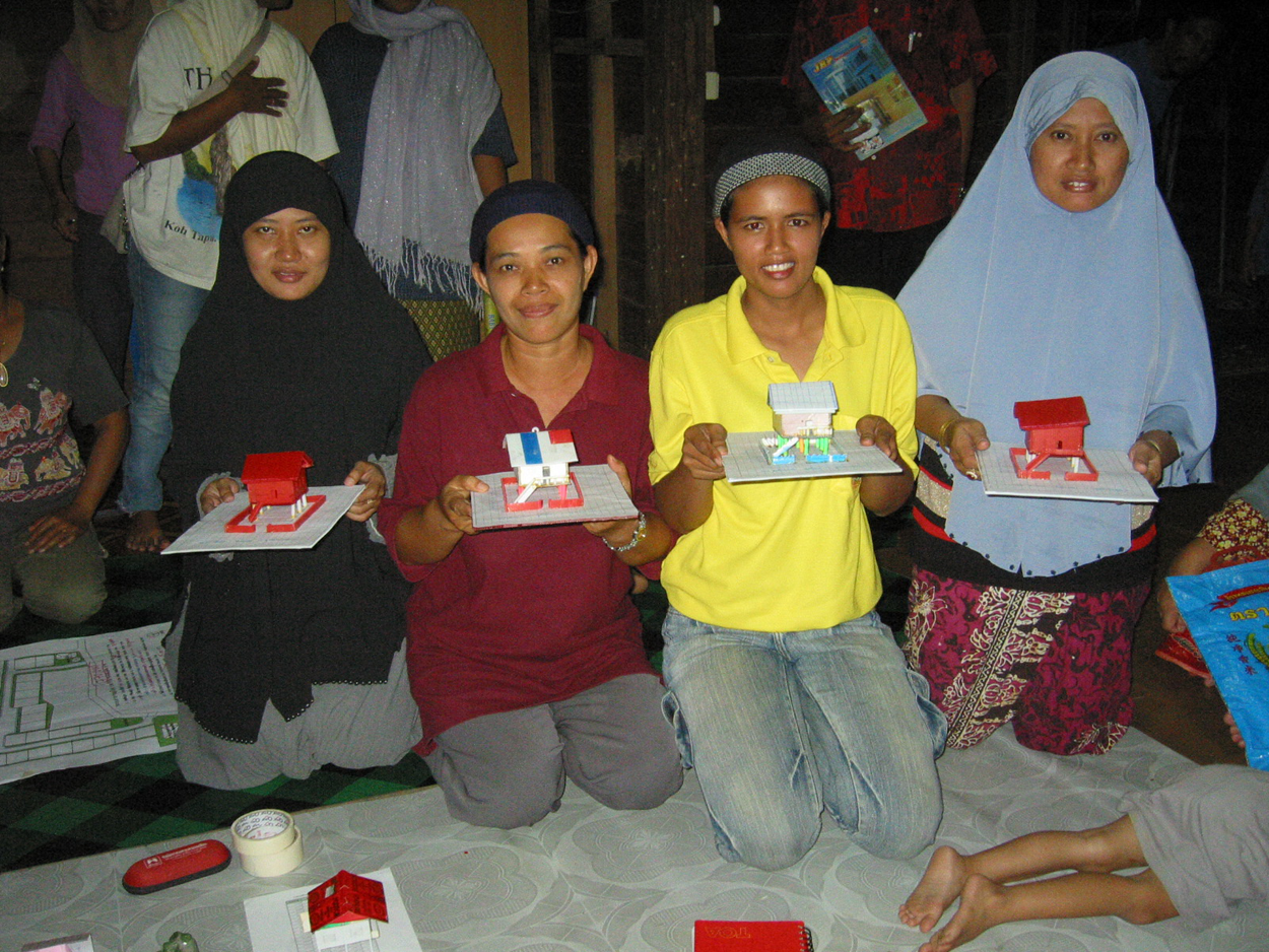
Women from Jabangdhikor community in Pattani province, southern Thailand present model houses based on their “dream houses”
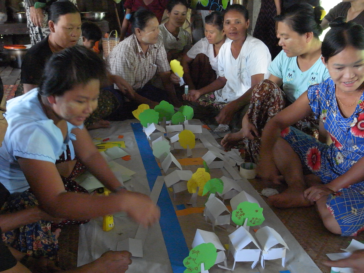
Women in Ale Yaw ward near Rangoon, Myanmar discuss possible layouts for the houses in their community
Once the housing plot sizes have been agreed upon, their arrangement on the plot of land needs to be discussed and experimented with. In the Ale Yaw ward on the outskirts of Rangoon, Burma (Myanmar), community residents were given small coloured squares of paper that they could arrange on a larger sheet representing the full community. Different layouts for the coloured squares were tried and in the end a cluster arrangement was selected. Houses were arranged in such a way that each family’s pig pen was near those of a cluster of neighbours in order to allow biogas generation from pig manure. A similar exercise was carried out in Pupo community in southern Thailand for a reconstruction project (Photo 8).
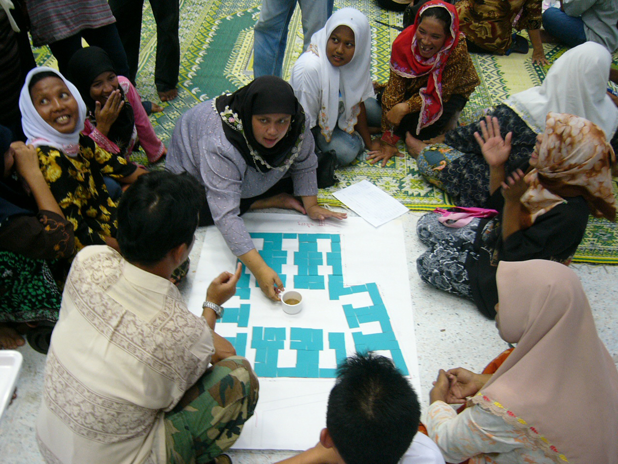
Community members in Pupo community, Pattani province, southern Thailand arrange squares representing house plots onto the larger paper representing the community site; this process allows people to visualize how they can live together within social clusters, with associated walkways, common areas and infrastructure
Once the layout has been finalized and approved by the community, the architects can help turn this into a scaled diagram that can be used during the construction process. In order to cement community cohesion during the process, common infrastructure can kick-start construction with, for example, pathways or the laying of drainpipes, activities in which all community residents have a stake and that allows them to feel a sense of ownership over the community. It is also possible to construct a “pilot” house, and in this case the community may choose to build the house of the community’s most deprived or struggling member, such as an elderly person, hence providing for this person while also allowing room for final adjustments to the house design before full-scale construction begins.
VI. Role of the Community Architect
Throughout the mapping and planning stages, community architects and other relevant professionals have to find the right balance for working with the community members, by providing sufficient guidance without controlling all the processes. Rather than providing all the answers, professionals should be asking the right types of questions, which will lead to the community finding the answers themselves and learning in the process. The mapping and planning processes should be framed in such a way that they can allow for the eventual formation of a platform for people to work together as a community and as a network. Therefore, in this case, the professional is not a mere architect or planner but also a community worker, able to read community dynamics and use them for the benefit of the whole community. These professionals need to be able to bring together the community’s physical and social aspects (Figure 2). If, as is usually the case, a natural community leader emerges through the collective processes, the professionals should give them the space to take the lead and gain the community’s trust.
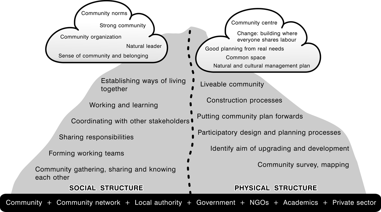
Diagram showing how physical and social aspects are built up and changed during the processes of housing by people; the role of community architects and other professionals is to ensure that the community’s social and physical aspects are considered in tandem
There are a number of ways in which professionals can facilitate community processes. They should provide a good working environment and space for community meetings where everyone feels equally able to speak out and share their thoughts and opinions. The professionals should be able to improvise and make use of whatever tools are to hand: the human body is a useful measuring tool for visualizing how large a room needs to be, while floor tiles can be used to mark out areas. However, they should not shy away from working with more technical tools such as maps and satellite pictures, and teaching community members how to read them in the process. They also need to be able to consider financial issues and help the community to ensure that their financial capacity will allow them to achieve what they have designed – this may mean helping to set up community-based revolving loan funds as well as finding potential sources of grants and loans. An architect who is disconnected from the financial realities on the ground will not be of much help to urban poor communities.
Ultimately, professionals working with communities need to recognize that the knowledge derived from community mapping belongs to the community, and they need to know how to represent it and use it. A clear goal for community architects and other support professionals is to make the process sustainable without their intervention: “Once community people know the process [of mapping] and realize that they are the ‘subject’ and the ‘key actor’ of their mapping, they can do it without social organizers.”(3) Sometimes, community architects make mistakes, and it helps if the community sees them as fallible and can even provide the right answer themselves.
Professionals working with communities also need to ensure that these can still receive support even once the professionals have gone – this means getting locally based professionals involved and drawing in student architects and planners, who themselves would have much to learn from working with communities. This also means getting the younger generation involved wherever possible; in Bharatpur, Nepal the process of compiling detailed community maps was undertaken by the youth group in each community, working with community architects and the local development organization.(4)
Of course, as well as the community development aspect, professionals need to put their technical skills to good use. When planning new communities and designing houses, architects need to keep at the forefront of the planning and designing the need to keep costs affordable by the community members. Often, they may have ideas for the re-use of old materials as well as how to build in the vernacular style, which will make for more climatically adapted housing. If there are skilled carpenters and artisans in the community, designs should take into account the skills they can offer. Alternative technologies, such as biogas or wind power, could also be applied if they can help keep living costs down.
VII. Conclusions
A demand-driven approach to housing the urban poor means that they should play an active role every step of the way, from identifying communities that face housing problems to planning new settlements and designing new houses. While these processes can be carried out by the urban poor themselves, they may benefit from judicious intervention by skilled professionals at various stages, who can help with technical aspects.
However, the role of the professionals extends beyond mere technical aspects – site planning is not just the design of house and infrastructure layouts, but also requires an understanding of the relationship of the people and their houses to the community’s physical and social context. Comprehensive site planning by community architects tries to weave together the community’s various components to build a liveable community. Community mapping by the people feeds into this by heightening the residents’ awareness of their interrelationships and interactions with the space they live in. Thus, comprehensive site planning can be a vital tool for finding the meaning of “living together” through ways of discussing, planning and sharing together, identifying what has made the community live well together thus far, and how it can be maintained and built up in the future. Mapping can support self-determination and self-organization, and in the longer run can contribute to processes of democratization from below. As such, mapping is not only the end product – it is also a process, and the output can be an improved understanding of the relationship of people with their place of living.
Footnotes
1.
2.
3.
See reference 1, page 3.