
Abstract
The residents of informal settlements face a diverse range of urban risks, from climate and economic shocks to local pollution and the threat of eviction. This article explores these risks by conducting Participatory Hazard Vulnerability and Capacity Assessments (PHVCA) in three informal settlements in the Cambodian capital of Phnom Penh. The assessment uncovers a variety of risks, which interact with each other and local vulnerabilities to produce complex risk profiles for residents. In this way, we highlight the importance of a holistic assessment of urban risk rather than focusing on single risks or specific sectors. The participatory approach also reveals household and community-level processes through which risks are experienced, negotiated and in some cases addressed, providing valuable insights into the ways vulnerable urban populations can be best supported.
Keywords
I. Introduction
Urban risk is complex and multi-scaled, encompassing issues ranging from global changes in climate to local changes in land use. Sources of risk can be environmental, socioeconomic, physical and political, and are often regarded as external influences on a city and its inhabitants,(1) such as extreme climate events or commodity price fluctuations. However, they may also be internal, such as land use change that has the potential for negative, unintended consequences.(2)
Making sense of the multiple risks facing those living in informal settlements is critical from a policy perspective if communities are to be supported to overcome them. To this end, community-centred studies have proved crucial to uncover local experiences of risk. Such studies have identified the complex ways that physical stressors, such as natural hazards and climate change, affect residents in informal settlements.(3) These studies show, for example, how floods or rising sea levels have local impacts through their synergy with local conditions, such as the extent and quality of drainage coverage and changes in the built environment, to create complex risk profiles for informal settlers.(4) They have also revealed how flooding interacts with a host of localized health risks, including mosquito-related diseases such as dengue, and water pollutant-based diseases such as typhoid, cholera and hepatitis.(5) As well as uncovering local-level aspects of urban risk relating to physical stressors, community-centred methodologies have assessed local vulnerabilities associated with informal settlements, such as the absence or inadequate quality of water and sanitation facilities,(6) lack of investment in service infrastructure,(7) poor-quality housing and the lack of tenure security.(8)
In general, assessments of the risks facing urban dwellers fit into one of two broad camps. First, they have assessed how global processes such as climate change have affected communities at the local level. Second, they have assessed common risks associated with living in informal settlements, such as tenure insecurity or low-capacity infrastructure. In each of these cases, studies have tended to focus on one main source of risk – be it flooding caused by rising sea levels, or tenure insecurity caused by government threats of eviction. Building on these approaches, this article broadens the scope of analysis to look at the spectrum of risks facing informal settlements and how they interact with each other. Increasingly, vulnerability research emphasizes the importance of considering multiple risks and how they interact in places,(9) since individuals, communities, cities and nations experience a wide range of cross-cutting socio-political, economic and environmental changes that interact in often complex, synergistic and uncertain ways.(10) However, there are relatively few empirical studies that take such a holistic approach, especially in low-income urban settings.
In this study, we present participatory case studies of multidimensional risks facing residents of three informal settlements in the Cambodian capital of Phnom Penh. The city is home to an estimated 1.6 million people, including around 250,000 informal settlers – approximately 15 per cent of the overall urban population – according to a recent survey by Phnom Penh Municipality.(11) This population is exposed to a variety of risks, both environmental and socioeconomic in nature. To date, most risk assessments in Phnom Penh have focused on the socioeconomic risks of tenure insecurity and the threat of eviction as the key issues facing those living in informal settlements.(12) This is not surprising, given that over the past two decades, tens of thousands of households have been evicted from central urban areas.(13) But while tenure insecurity has been widely discussed, there are a host of other risk factors that urban communities face, which have received much less attention.
In particular, high exposure to flood risks renders Cambodia one of the most disaster-prone countries on Earth, and one of the countries most likely to suffer from climate change.(14) In the context of rapid urbanization, Cambodia’s cities are thought by government and NGOs to be key sites of future vulnerability. Informal settlements are particularly susceptible as they are often located in peripheral areas prone to flooding and contain dwellings made of non-durable materials.
Despite the growing threat to urban areas, studies of disaster risk and vulnerability to climate change in Cambodia are almost exclusively focused on rural areas.(15) Recently, however, there have been signs that the government is beginning to focus on urban risk. This study contributes to increasing the understanding of interacting risks facing urban areas in order to support future urban risk reduction initiatives.
II. Assessing Risk in Phnom Penh’s Informal Settlements
a. Background to the research project
The Cambodian government is increasingly cognizant of the risks facing urban areas, and has sought to address these risks primarily through disaster risk reduction (DRR) reforms. The National Action Plan for Disaster Risk Reduction for 2014–2018, for example, emphasizes the growing threat of disasters in urban contexts. In response, the government has developed a number of institutional mechanisms to build the resilience of urban areas. The most important of these are committees for disaster management, which work across ministries and mobilize funds to build the disaster resilience of urban areas at various scales. These committees are under the overall control of the National Committee for Disaster Management (NCDM), headed by the prime minister. In urban areas, resilience building is under the remit of sub-national institutions, with the municipal, district and commune authorities playing key roles in Phnom Penh. At the municipal scale this role includes, for example, identifying areas where flood defences should be built. At the commune scale, it involves identifying investments that will lessen the impact of disasters at the local level, such as upgrading roads and other local infrastructure.
While there is an institutional framework to address disaster risks in Phnom Penh, there is a lack of community-level information on which to base programming decisions. Currently, the primary policy focus is on emergency responses to city-wide threats such as floods and fires. However, there are limited data on the complex ways that risks are experienced in informal settlements and how their resilience to these risks can be strengthened over the longer term. To generate these data, the NGO People in Need (PIN) conducted research to explore the multidimensional risks faced by urban dwellers in informal settlements as part of a project funded by the European Civil Protection and Humanitarian Operations (ECHO) Disaster Preparedness Programme. In 2015, a PIN-led research team was tasked with developing a participatory toolkit that would capture the range of risks facing residents of informal settlements and implementing the methods in vulnerable communities. In carrying out this task, the team worked closely with grassroots organizations with long histories of community organizing, and which had previously engaged in participatory mapping and enumeration exercises in Cambodia – the Urban Poor Women for Development (UPWD) and the Community Development Fund (CDF). It was envisaged that the participatory approach would generate data that could feed into government and civil society organization (CSO) risk mitigation strategies targeted at informal settlements.
b. Methods
The key methodological tool used in this research is the Participatory Hazard, Vulnerability and Capacities Assessment (PHVCA). PHVCAs capture: (i) multiple hazards that become risks when a community is exposed to them; (ii) sensitivities (referred to as vulnerabilities); and capacities. In vulnerability theory, sensitivity refers to susceptibility to harm from one or more risks,(16) which can differ according to characteristics, such as class, gender, generation, ethnicity and other factors.(17) By identifying capacities, a PHVCA collects data on the ability of the community and individuals to minimize, cope with, recover from and adapt in response to the impacts of shocks and stressors. Together these factors help to explain the vulnerability of a community to multiple, interacting risks. To this end, we adopted a number of PHVCA participatory research tools, including participatory mapping exercises, hazard assessments, the development of historical timelines and seasonal calendars, stakeholder analysis and transect walks.
The PHVCA assessments were conducted over three days in each of three study sites. Prior to conducting the PHVCA, local savings group members assisted in the selection of 10 participants from their community to represent a range of social groups, including women, youth, elderly and disabled. On the first day, we implemented the above tools at a PHVCA workshop, which was facilitated by community mobilizers from CDF and UPWD, who were well known to the community. The second day was used to reflect on key issues with PIN and CDF/UPWD staff, and the third day to revisit the community, walk around and talk to residents who had not attended the PHVCA.
c. Research sites
We selected three communities as sites to implement the PHVCA after consultations with local authorities and CSOs. The communities of Borei Doemsrol, Chamrouen and Vealsbov were selected because they faced risks and had vulnerabilities that were common to many informal settlements in Phnom Penh, including tenure insecurity, poor sanitation coverage, exposure to flooding and poor-quality housing.
Borei Doemsrol
The Borei Doemsrol community is a long-established settlement located on the banks of the River Sap, in the north of the city. Given its riverside location, it is highly exposed to flooding. The first residents settled on the site in 1979, the year the city was liberated from the Khmer Rouge regime. Originally, the community consisted of 10 households, which had increased to 74 households at the time of the fieldwork. The community became organized around a savings group in 2011.
The major employer in the survey area was a soft drinks factory, where about 50 per cent of residents engaged in stable, waged labour. A further 10–20 per cent of residents, solely women, worked in garment factories. The remaining households worked in a variety of occupations, including low-level civil service, small businesses, market vending or driving motorcycle taxis. Elderly people grew crops on the river, and washed clothes and performed other household tasks while working-age people were at their place of employment.
The community is well located for social services. Health centres and schools (primary and secondary) are within 0.5 kilometres of Borei Doemsrol, over 90 per cent of households are connected to piped water direct from the municipal supplier, and all are connected to the municipal electricity supply. All households are also connected to sewerage infrastructure, which deposits effluent directly into the river some 100 metres offshore, and the area is also served by municipal garbage collection services.
The buildings in the community are of a good quality in comparison to other sites surveyed. Overall, around 40 per cent of buildings are wooden, 35 per cent concrete and wood, and 25 per cent concrete. Only two households have legally documented ownership rights; the rest rely on documents issued at the local level, such as family books (documents issued by local authorities detailing household members registered to an address) or property transaction receipts. The community suffers tenure insecurity, and has been subject to frequent threats of eviction from local authorities who want to “beautify” the riverside area.
Chamrouen
Like Borei Doemsrol, the Charoen community was established in 1979 on vacant marshland, prone to flooding, on the city’s outskirts. It had grown from an initial six households to 231 households in 2015, when our fieldwork was conducted. The community organized around a savings group in 2004.
Most households work in the informal sector. About 80 per cent of the population was employed in Echai (collecting recyclable material and selling it to recycling companies), including women and children. Around 10 per cent worked in construction and garment manufacturing, and a small number in the entertainment industry, informal food processing, washing clothes, babysitting, and as motorcycle taxi drivers. Older people in the community looked after children and completed other domestic duties.
The settlement has access to primary and secondary schools, and a health centre within 1 kilometre; it is also connected to municipal electricity and water services. However, no drainage or sewerage systems are available. Instead, latrines are widely used for human waste disposal. The area is not served by municipal garbage collection services.
The majority of houses are built of wood and other non-durable materials, and no households have formal tenure documents. However, the community has a good relationship with local authorities, and public infrastructure investments have been made in the settlement. Because of this, tenure insecurity and the threat of eviction was not considered a pressing issue.
Vealsbov
Vealsbov, lying on the urban fringe of Phnom Penh, is the most peripheral of the settlements. The settlement is located on marshland with a history of waterlogging and flooding and the presence of numerous dangerous animals and insects, including snakes, scorpions and poisonous centipedes. There are two groups of families in the area who settled at different times. The first group arrived in 1994 and consisted of 25 households; the second group arrived in 2009, and consisted of 57 households. A savings group was established in the community recently, although participation has not been strong so far.
As in Chamrouen, most households work in the informal sector. Around 80 per cent are Echai or recycling workers; 10 per cent work in construction and 10 per cent as garment workers – although recently some had lost their jobs when a garment factory closed. As in the other communities, elderly women are tasked with domestic responsibilities while working-age people earn a wage.
The area is located relatively far away from services. The nearest primary school is 4 kilometres away, the nearest secondary school is 7 kilometres, and the local health centre is 4 kilometres. None of the dwellings is connected to municipal electricity services and most use batteries for electricity supply. Only a few households have access to piped municipal water services; most purchase water by the bucket from private sellers. No municipal garbage service is available for residents, so rubbish is strewn around the settlement and/or burnt. There is no sewage or drainage coverage and, in total, only seven latrines serve the entire community.
The housing structures in the community are, in general, of very poor quality, with the majority constructed mainly of wood or less durable materials such as bamboo thatch. No households reported having tenure documents, and community members have been threatened with eviction by local landowners.
III. Interacting Risks in Phnom Penh
In this section, we discuss the findings from applying the PHVCA in the three Phnom Penh sites. First, we identify the social and environmental risks facing the communities; we then explore how the residents’ socioeconomic conditions determine their sensitivity to the risks and their capacities and strategies to deal with them. We show how the different sources of risk intersect with one another to variably affect different social groups.
a. Sources of risk
The peripheral locations of informal settlements often leave them exposed to a variety of risks. In our survey sites, residents occupied low-lying areas and/or plots on riverbanks that can be inundated with floodwater for much of the wet season and/or that are vulnerable to major flood events. In addition, rapid development of peri-urban areas has caused the loss of wetlands and has sealed land,(18) resulting in enhanced surface run-off into the low-lying sites of informal settlements. Living with the floodwaters is a challenge, but in settlements where residents had been threatened with eviction, resettlement away from their established home and livelihoods was considered to be a worse risk. Lastly, organized, violent and petty crime presents a constant risk to the wellbeing of the communities.
Wet-season waterlogging
Residents in all three sites were affected by waterlogging during the annual wet season, which inundates homes and local infrastructure, making everyday tasks difficult. Settlements are typically submerged in 1.3–1.7 metres of water for up to six months of the year. This annual cycle correlates with fluctuations in the water level of three major rivers (the Mekong, the Sap and the Bassac, which meet in Phnom Penh), as well as monsoonal intra-annual rainfall variability. Waterlogging presents challenges to the mobility of residents, constraining livelihoods and making domestic tasks difficult. The annual inundation also damages infrastructure and properties, and creates conditions for waterborne disease contagion. Consequently, expenditure on property repairs and medical treatment increases during the wet season, which exacerbates the indebtedness of many households.
River flooding
A significant source of risk to Phnom Penh’s informal settlements is the major flooding of the rivers, which has occurred several times in recent years. Most recently, the 2011 and 2013 Mekong floods, which also affected the neighbouring countries of Thailand and Laos, devastated Cambodia, causing hundreds of deaths and destroying thousands of homes. All three communities had experienced major flood events in the recent past from one of the three main rivers or their tributaries. During these floods, communities reported that waters reached up to 1 or 2 metres higher than the levels experienced during typical wet-season waterlogging.
River floods differ from normal wet-season waterlogging in two key respects. First, the waters are much higher and flow faster. Dwellings that could withstand normal waterlogging could be destroyed in a flood year. Second, major river floods are rapid in their onset. Two of the three communities are close to levees or the overflow channels of rivers, and when these defences are breached, water levels can rise by several metres in just a few hours, providing little opportunity for residents to evacuate themselves or their belongings. In all three settlements, river flooding can result in the loss of property and life.
Rapid urban development
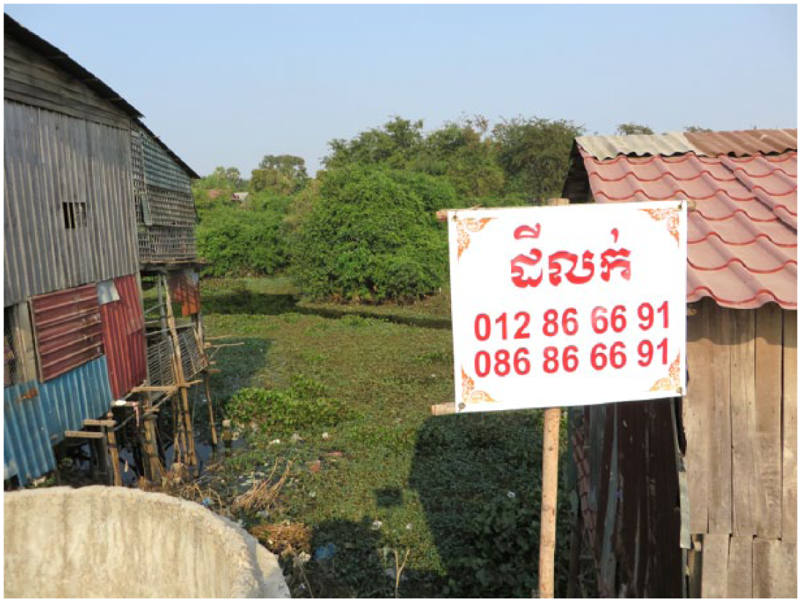
Two of the surveyed communities are situated in peri-urban areas where rapid urban development has generated new sources of flood risk. The construction of residential and commercial units in Phnom Penh’s peri-urban districts involves the filling of marshlands, which provide critical floodwater and wastewater regulation and storage services to the city. This development is private sector-led, subject to minimal regulation, and has not been supported by the expansion of municipal drainage infrastructure. This pattern of development has had severe consequences for the communities we visited. Over the years, marshland development has had a ratcheting-up effect: developers build their land sites progressively higher to drain water, resulting in the increasing accumulation of water in the lowest-lying areas of the city (Photos 1–4). The lowest areas are occupied by the poor, living in informal settlements, who cannot afford to raise the level of their land or to drain it.
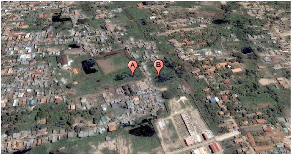
Chamrouen area in 2005
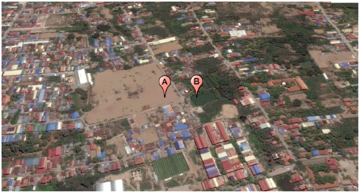
Chamrouen area in 2015
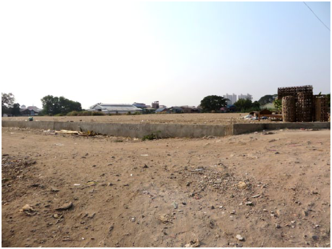
Ground-level view of Marsh ‘A’ in 2015.
Ground-level view of Marsh ‘B’ in 2015.
According to residents, there are two clear differences between the flooding associated with the rivers and that related to development. First, the development-related floodwaters take longer to recede. In a typical year, before the rapid development began, respondents in the Vealsbov community reported that their settlement would be waterlogged for four or five months each year. Now, parts of the settlement are waterlogged for up to eight months of the year. Community members attributed the the increased flood duration to the filling of surrounding wetlands for new developments, which has reduced the natural drainage reservoirs for the settlement. Development has also caused the quality of floodwater to progressively deteriorate over the years. Residential development, poorly serviced by drainage and sewage infrastructure, and a growing number of nearby factories are suspected of increasing the amount of chemical, pathogenic and microbial pollution mixing with floodwaters. Residents stated emphatically that the drainage of these contaminated waters into their settlements has worse effects than river flooding. One participant explained: “When we were flooded by the river, the water was clean. Now water comes from the higher ground built up all around, and also from the ground. The water from the ground is brown and warm, I think it is the sewage systems from all the surrounding developments overflowing.”
The increased presence of polluted floodwater is likely to be exacerbating the disease outbreaks associated with wet-season waterlogging.
Tenure insecurity
A key risk facing residents in all sites is tenure insecurity. All the surveyed sites are considered illegal settlements; no households hold tenure documents that would prove legal ownership. In two out of the three sites, residents had been threatened with eviction. Participants reported that if evictions were to occur, the impacts would be very severe, as many residents are heavily dependent on the proximity of their locality to livelihood opportunities and, in the case of Chamrouen and Borei Doemsrol, social services, such as health care centres and schools. In communities threatened with eviction, it was notable that relocation was identified as a more severe risk than flooding. In such areas, families do not want to migrate to safer areas despite the significant effect of floods. River flooding, in particular, is generally regarded as a hazard that can be lived with. In Borei Doemsrol, a community affected predominantly by river flooding, one resident noted, “of course we can survive the river flooding – it is a natural occurrence”. Even in areas with development-related flooding, while the contaminated waters were considered a major risk, eviction was still considered to be a worse risk.
Crime
Participants in all three sites face a range of crime risks. In Vealsbov community, a quiet path leading from the main road was identified as a site associated with serious crime that had negatively affected residents. Women are particularly vulnerable to being robbed and, in some cases, have been subjected to serious sexual assaults. In 2010, for example, a seven-year-old girl was allegedly dragged from the road and raped in nearby shrubland. Domestic violence is also a problem in Vealsbov; according to focus group participants, about half of women suffer regular physical violence from men, which they blame on the consumption of alcohol and other recreational drugs. A common concern voiced during PHVCAs in all communities was the effects of drug dealing and addiction, particularly on younger members of the community. Parents were concerned that local “gangsters” co-opt vulnerable youngsters into criminal activity. In response, several NGOs have held training exercises to educate people on social issues including alcohol and drug abuse, domestic violence and sexual assault, though it is unclear if these have been successful to date.
b. Sensitivities and capacities
The PHVCA revealed a number of sensitivities to the above risks associated with residents’ socioeconomic situation and the lack of government support for informal settlements, including poorly constructed dwellings, low-capacity infrastructure, and inadequate access to water, sanitation and hygiene (WASH) services. The different circumstances of households affected the degree to which they were at risk. Residents in all three of the communities demonstrated capacities and strategies to lessen the impact of environmental and social risks, albeit with varying degrees of effectiveness.
Poor-quality dwellings
Many residents live in self-built housing made from non-durable materials that are vulnerable to damage. Seasonal waterlogging weakens poor-quality housing foundations over time, necessitating repairs. In major flood years, widespread and severe damage to housing is reported, often destroying dwellings. In addition to water-related damage, high winds cause damage to property, particularly to rooftops. In one extreme case, a storm resulted in the destruction of 14 dwellings in Vealsbov.
Households reduce their vulnerability by strengthening the construction quality of their homes. Most commonly, buildings are raised above the wet-season waterline on stilts, foundations are strengthened and/or wooden houses are reconstructed using concrete and bricks. These improvements are made using household labour or the services of construction workers, who are often residents in the village themselves.
In some cases, the poorest residents respond to waterlogging by deconstructing their dwellings and rebuilding them on rented plots of dry land in safer areas before the start of the wet season, and then move back to their plots when the floodwaters subside. The longer duration of annual flooding caused by nearby development means that affected residents stay in temporary accommodation on rented land for longer periods of time, incurring additional costs. In contrast, even in major flood years, those in sturdier homes remain in their dwelling, sometimes constructing makeshift living quarters on their roofs if the floodwaters inundate living areas.
Most residents pay for housing strengthening and/or (de)construction with funds borrowed from their savings groups or from microfinance companies. The use of microfinance loans was in some cases problematic and provided new forms of vulnerability: while microfinance loans are widespread and easy to access, they often have very high rates of interest and, as a result, families often find themselves taking out further loans to repay older ones. These repayments make it very hard for indebted households to cover other living costs. Thus, although access to credit can facilitate risk reduction strategies, the associated debt often replaces one source of vulnerability with another.
Securing safe housing was easier for some households than others. Better-off families built sturdier structures, and could finance the rebuild or repair of their house if it was damaged. In contrast, poorer families run the risk of falling into spirals of debt as they struggle to pay for expenses associated with recurrent floods. Of the poorest households, those headed by women and those comprised of the elderly often live in the worst-quality accommodation and find it particularly difficult to reconstruct or repair dwellings because they lack household labour. Instead, such households hire construction workers to fix their dwellings, often funded with microfinance loans, resulting in increased debt and economic hardship.
Vulnerable transportation network
Roads submerged by floodwaters inhibit the mobility of residents and put their health at risk. Children were identified as particularly at risk because they tended to be more likely to fall into, and less able to escape, floodwaters. In 2010, for example, an 11-year-old girl drowned while eight others were rescued by community members in Chamrouen. Pregnant women were also identified as a particularly vulnerable group because of their reduced mobility. Focus group participants in Vealsbov noted that pregnant women had been known to miscarry after slipping in potholes in submerged mud roads.
Constraints on mobility can prevent residents from accessing urgent medical treatment. Participants from Vealsbov noted that in recent years three women gave birth en route to the hospital, while a baby with a high fever died during the journey. Wading through water also carries the risk of being bitten by snakes, scorpions and centipedes. In Vealsbov, for example, participants estimated that as many as 10 per cent of community members had been bitten by poisonous snakes for which they required urgent medical treatment.
In addition to these direct impacts on wellbeing, limited mobility poses challenges to residents’ livelihoods. Those engaged in informal livelihood activities are more severely affected by floods than those employed in waged labour. In Borei Doemsrol, for example, the largest source of employment is factory labour. During periods of flooding, the factory remains open and provides workers with a reliable income source. In contrast, between 50 and 80 per cent of residents in the other two survey communities are informal recyclers (Echai) who scour nearby areas for plastic bottles, which they sell to local recycling brokers. Waterlogging frequently makes this work impossible, meaning this source of income ceases for several months each year. The Echai and subsidiary industries have adapted to this by organizing the collection of garbage in other areas, with brokers transporting them to the coastal city of Sihanoukville to collect garbage. Despite these responses, shortfalls in income are still experienced by most households during the wet season, with microfinance loans often used to meet basic needs. The longer waterlogging periods associated with development-related flooding increased income shortfalls and debt.
The extent to which communities and individuals have adapted to roads and paths being submerged by floods depended on the characteristics of each settlement. Two of the three settlements have existed for over 30 years and residents are organized around strong savings groups, allowing them to upgrade their infrastructure over time. Joint investments were reported between community savings groups and local authorities to upgrade infrastructure. While this was intended to reduce flood risk, the cultivation of a positive relationship with the local authority lessened the threat of eviction too. In Chamrouen, for example, participants indicated that their tenure was safe for the immediate future (even though they did not have formal tenure documents) because of a joint investment in a road and a strengthened dyke. Thus, in the same way that different forms of risk interact, there can be synergies between responses: in this instance reducing the risk of tenure insecurity and flooding. Improvements made to travel infrastructure included a network of raised walkways to connect dwellings to one another and to main roads (Photo 5). During major floods, when these walkways become submerged, entrepreneurial residents earned an income shuttling residents across floodwaters using tyre inner tubes or small boats.
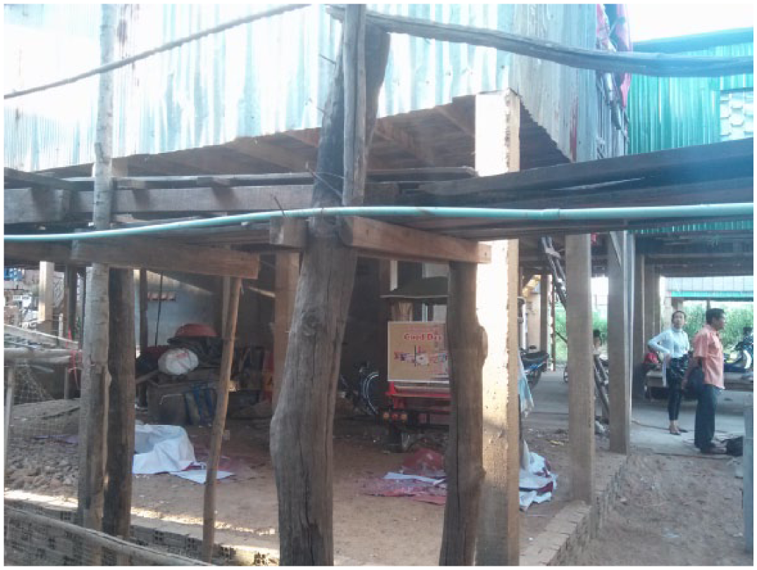
Raised housing, walkway and water pipe above the typical wet-season high waterline (photo taken in the dry season)
Low-capacity sanitation systems
The prevalence and severity of disease vary across the settlements and their households, according to the standard of sanitation and access to safe water. Borei Doemsrol is the only settlement studied with a piped sewer system, installed by a local benefactor. The system functions all-year-round, (although it can be rendered unusable in times of severe flooding), but it pollutes the river by depositing effluent 100 metres from the riverbank. In the other two settlements, sanitation services are more rudimentary. Although some households have latrines, these are unusable in the wet season as they are situated below the high watermark; they frequently leak sewage into surrounding watercourses. People without latrines defecate into plastic bags that are then thrown into open spaces underneath and between dwellings, along with other household rubbish (Photo 6). During periods of waterlogging, this human waste pollutes the water.
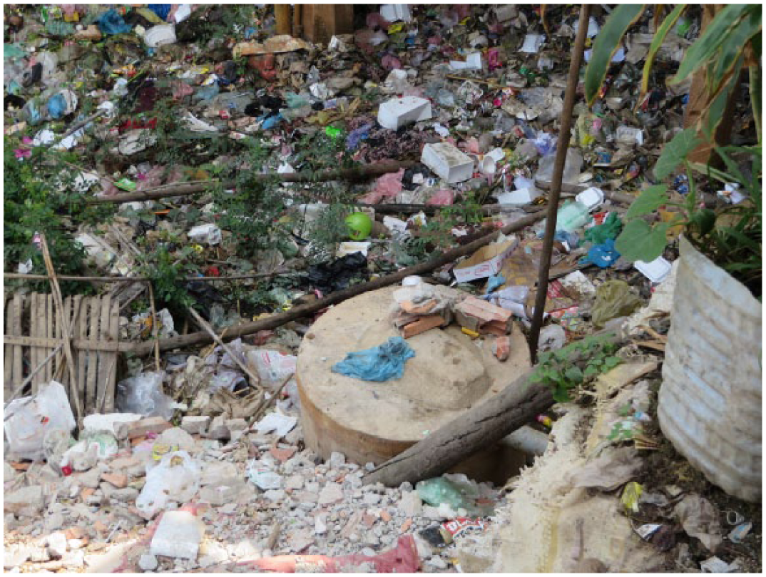
Latrine below wet-season waterline (photo taken in the dry season), surrounded by bags of human waste and other rubbish
Children are particularly susceptible to illness related to stagnant water and poor WASH coverage. In Chamrouen, it was reported that between 20 and 30 children (out of a population of approximately 350) suffered from dengue fever each month, and around five had died in the past five years. Other illnesses reported included the Chikungunya virus, cholera, diarrhoea and skin infections. After the water dries, the residue from the flood presents other health issues, such as conjunctivitis. These illnesses are relatively expensive to treat, forcing people to take out loans from microfinance companies. In the settlements with the least sophisticated sanitation systems, residents reported the most severe and highest incidence of illness.
The community savings group was identified by focus group participants in all settlements as crucial to upgrading water and sanitation coverage. For instance, the municipal water authority refused for many years to supply piped water to the Borei Doemsrol settlement, but services were extended to the area when a community savings group organized the connection of individual households and provided loans to those who could not afford the connection costs. In Chamrouen, the community savings group obtained formal electricity connections from the municipal supplier and negotiated electricity rates 60 per cent below the normal cost. The savings group also made funds available for the construction of latrines and promoted their uptake. As a result, latrine coverage increased from 0 to 70 per cent of households between 2004 and 2015. The group was also an important conduit for information on hygiene and disease issues. It was credited with reducing mortality associated with dengue fever in babies by educating mothers about the warning signs of when medical attention is required.
IV. Discussion and Conclusions
This article presents a participatory approach to the study of urban risk in three informal settlements in Phnom Penh. We have shown how several urban risks interact with each other and with community vulnerabilities to affect the wellbeing of residents. In doing so, we have demonstrated the value of a holistic approach to understanding the vulnerability of the urban poor, as compared to the sectoral, disciplinary, single-risk focus that characterizes most empirical studies of urban risk.
Informal settlements in Phnom Penh are often located in risk-prone areas, which are typical of many urban environments across the globe.(19) Such locations include riverside areas exposed to river flooding and/or low-lying sites where rainfall collects and accumulates during the wet season. Consequently, settlements are inundated with floodwater for long periods of the year and residents are at risk of disease, livelihood disruption and property damage. This situation is exacerbated by the rapid urban development of peri-urban marshland areas, which is reducing wetland storage of floodwater and increasing run-off into the remaining low-lying areas, where informal settlements are located. In addition, heavy rainfall events in upstream catchments can cause major flood events periodically, amplifying the existing flood risk in Phnom Penh. These risks interact with the vulnerability context of the communities: poor transport, sanitation and water provision infrastructure, poor-quality dwellings, tenure insecurity, and livelihood and health costs associated with dealing with recurrent floods and disease outbreaks. These interactions ultimately cause ill health and prevent the accumulation of individual and community assets or the building of sustainable livelihoods, which are required to escape poverty and improve wellbeing.(20)
The case studies show how responses can attenuate but also, unintentionally, amplify risks.(21) Microfinance was a key mechanism for coping with income shocks caused by flooding, but may have amplified vulnerability in the long term by increasing indebtedness. The case studies also demonstrated how risks create opportunities as well as negative impacts, such as entrepreneurs providing ferry services over floodwaters. Despite the risk, people can be attached to vulnerable places because of other features that function there to strengthen their resilience – for example, the accessibility of livelihood opportunities.
The interacting risks resulted in seasonal, spatial and social variations in vulnerability. Seasonally, we found that in periods with heavy rains the risks facing communities became particularly severe. Waterlogging and floods damage low-quality dwellings, overwhelm sanitation systems, reduce mobility and cause ill health. This points to the importance of considering the dynamics of vulnerability in urban settings: individuals and communities are more or less vulnerable at different periods of the year. The dynamics of seasonal variation in risk were found to have changed over time in some settlements. Specifically, annual periods of waterlogging became more extended as a result of the increased run-off from land sealed for development. Spatially, we found that exposure to risks is unevenly distributed across settlements. The least-established settlements appeared to have less resilience to shocks than longer-established ones, which tended to have stronger community groups, more developed relationships with local authorities and, consequently, better public infrastructure and services that lessened their vulnerability. Finally, social status within settlements is also important in determining how people experience risk. Two groups that tend to suffer most are women-headed households and households comprised of elderly people with no working-age members. These groups have less household labour to draw upon to strengthen, repair or rebuild damaged dwellings, and lower earnings and savings needed to cope during periods of extreme hardship.
The highly localized nature of risks facing informal settlements illustrates the importance of integrated settlement upgrading. If responses to risks are considered in isolation, there is a danger that in addressing one, others may be exacerbated. For example, an important finding was that communities exposed to severe flooding strongly resisted relocation as a strategy to mitigate risk. Instead, eviction was considered to be the most severe risk they faced, because of the effect of relocation on livelihoods. This has important policy implications for how authorities assess and make trade-offs between risk mitigation options that may have unintended consequences for the poor.
This study also found community-based organizations to be a key resource in reducing multidimensional risks facing informal settlers. In this regard, savings groups appeared to be particularly important. Such groups not only provide an important source of financial capital for resilience-building community investments, but also strengthen community cohesion, disseminate information about healthcare and hygiene, and facilitate relationships with external actors, such as local authorities and utilities companies, to secure investment in local infrastructure and services. In contrast, while microfinance loans provide an important source of capital for households to make resilience-building investments and deal with the short-term effects of shocks, they potentially undermine long-term resilience by increasing indebtedness.
Some risks seem beyond the realm of community-based adaptation alone and will require larger shifts in policy. Two key risks in this regard were tenure insecurity and development-induced flooding. Both of these risks stem from inequitable and weak legal and institutional frameworks for urban development, and may require changes in policy at the national scale. This highlights the need to engage with the political and institutional causes of vulnerability to mitigate urban risk.(22)
An important policy challenge given the localized nature of urban risk is representing the varied experiences of informal settlers in effective resilience-building responses. The PHVCA methodology has limitations in terms of whether the focus group participants are representative of the community and in its ability to identify inter- and intra-household differences in vulnerability. However, it was found to be an effective approach to rapidly gather data on multiple urban risks, sensitivities and capacities from the perspective of communities, which can inform urban risk reduction strategies that may be feasible, acceptable and contextually relevant to target communities.
Footnotes
1.
Chambers, R (1989), “Editorial introduction: vulnerability, coping and policy”, IDS Bulletin Vol 20, No 2, pages 1–7.
2.
Fussel, H M (2007), “Vulnerability: a generally applicable conceptual framework for climate change research, Global Environmental Change Vol 17, No 2, pages 155–167; also Sumner, A and R Mallett (2011), “Snakes and ladders, buffers and passports: rethinking poverty, vulnerability and wellbeing”, Working paper, International Policy Centre for Inclusive Growth.
3.
Djordjević, S, D Butler, P Gourbesville, M Ole and E Pasche (2011), “New Policies to Deal with Climate Change and Other Drivers Impacting on Resilience to Flooding in Urban Areas: The CORFU Approach”, Environmental Science and Policy Vol 14, No 7, pages 864–873.
4.
Douglas, I, K Alam, M Maghenda, Y Mcdonnell, L McLean and J Campbell (2008), “Unjust waters: climate change, flooding and the urban poor in Africa”, Environment and Urbanization Vol 20, No 1, pages 187–205; also Adelekan, I O (2010), “Vulnerability of poor urban coastal communities to flooding in Lagos, Nigeria”, Environment and Urbanization Vol 22, No 2, pages 433–450.
6.
Wegelin-Schuringa, M and T Kodo (1997), “Tenancy and sanitation provision in informal settlements in Nairobi: revisiting the public latrine option”, Environment and Urbanization Vol 9, No 2, pages 181–190.
7.
Varley, A (2002), “Private or Public: Debating the Meaning of Tenure Legalization”, International Journal of Urban and Regional Research Vol 26, No 3, pages 449–461.
8.
Payne, G (2005), “Getting ahead of the game: a twin-track approach to improving existing slums and reducing the need for future slums”, Environment and Urbanization Vol 17, No 1, pages 135–146; also Gilbert, A (2002), “On the mystery of capital and the myths of Hernando de Soto: What difference does legal title make?”, International Development Planning Review Vol 24, No 1, pages 1–19.
9.
Turner, B L, R E Kaperson, P A Matson, J J McCarthy, R W Corell, L Christensen, N Eckely, J X Kasperson, A Luers and M L Martello (2003), “A framework for vulnerability analysis in sustainability science”, Proceedings of the National Academy of Sciences Vol 100, No 14, pages 8074–8079; also Adger, W N (2006), “Vulnerability”, Global Environmental Change Vol 16, pages 268–281.
10.
Bennett, N J, J Blythe, S Tyler and N C Ban (2016), “Communities and change in the Anthropocene: understanding social-ecological vulnerability and planning adaptations to multiple interacting exposures”, Regional Environmental Change Vol 16, No 4, pages 907–926.
11.
12.
Khemro, B H S and G Payne (2004), “Improving Tenure Security for the Urban Poor in Phnom Penh, Cambodia: An Analytical Case Study”, Habitat International Vol 28, No 2, pages 181–201.
14.
15.
Flower, B and M Fortnam (2015), “Urbanising Disaster Risk”, accessed 27 October 2016 at http://www.preventionweb.net/files/submissions/47109_urbanisingdisasterriskreportinteractive.pdf; also Parsons, L (2015), “Environmental Risk and Contemporary Resilience Strategies in Rural Cambodia”, in K Brickell and S Springer (editors), The Handbook of Contemporary Cambodia, Blackwells, Oxford.
16.
Blaikie, P, T Cannon, I Davis and B Wisner (1994), At Risk: Natural hazards, people’s vulnerability and disasters, Routledge, London.
17.
Chant, S H (2007), Gender, Generation and Poverty: Exploring the Feminisation of Poverty in Africa, Asia and Latin America, Edward Elgar Publishing, London.
18.
“Sealed” refers to the process of wetland areas being converted into land that can be developed. Typically, this involves the filling of wetland areas with sand. This process means that natural water reservoirs have become “sealed” land parcels, which has implications for flooding.
19.
Hewitt, K (1997), Regions of Risk: A Geographical Introduction to Disasters, Addison Wesley Longman, Essex.
20.
Addison, T, C Harper, M Prowse, A Shepherd, A Barrientos, T Braunholtz-Speight, A Evans, U Grant, S Hickey and D Hulme (2008), The Chronic Poverty Report 2008/09: Escaping Poverty Traps, Chronic Poverty Research Centre, University of Manchester, Manchester; also Chambers, R and G Conway (1992), Sustainable rural livelihoods: practical concepts for the 21st century, Institute of Development Studies, Brighton.
21.
See reference 10.
22.
Cutter, S L (1996), “Vulnerability to environmental hazards”, Progress in Human Geography Vol 20, No 4, pages 529–539.