
Abstract
Population pressure, urbanization and industrial developments, among other factors, have resulted in severe degradation of environmental resources such as wetlands. In the face of increased climate variability, several hazards continue to emerge, affecting the vulnerable sectors of society, especially the poor. Risks due to hazards and vulnerabilities are context specific; they are shaped by causal mechanisms and local conditions, which need to be understood if risks are to be reduced. In this paper, a range of hazards, perceived vulnerabilities and associated factors among wetland communities in Kampala have been analysed. The analysis is based on a survey of 551 households using semi-structured interviews, focus group discussions and key informant interviews. The study focused on communities living in four wetlands that drain the city’s wastewater into Murchison Bay in Lake Victoria. Results show floods and waterlogging as the principal hazards; however, secondary effects of floods and waterlogging such as disease vectors and diseases affect more people than the floods. Tenants were more likely than landlords/homeowners to be exposed to floods, and households that spend more than US$ 80 per month were less likely than households that spend less to be exposed to floods. Households that had been exposed to floods before were more likely to perceive themselves as vulnerable. Variations in exposure to hazards and perceived vulnerabilities could be due to differences in the capacity to resist, cope with, or adapt to minimize vulnerability. An investigation of adaptation mechanisms responding to the various hazards identified in this paper would enrich understanding of the elements that shape risk in this context.
I. Introduction
Our environment is comprised of two constantly interacting components: the natural and the social components.(1) The theoretical point of departure in this paper is based on this interaction, where pressure within social components is vented on nature, consequently degrading it. Hazards emerge and affect the vulnerable elements in both the natural and the social components. Risk scholars have crafted conceptual approaches to estimating risk as a function of hazard and vulnerability factors.(2) According to Turner et al.,(3) vulnerability studies need to address three important aspects if they are to support evidence-based policy and practice. These aspects are: a study of all the hazards affecting the system (community or environment); how the system gets exposed to the hazard; and the coping capacity of the system.
A number of studies have been done on flood risk in African cities,(4) mostly using deterministic models. The opinions of local communities, which provide contextual explanations, are often overlooked. Yet estimation of flood risk is complex and could be grossly inaccurate in cases where historical data are unavailable or where human activities have significantly influenced local hydrologic phenomena. In this paper we specifically investigate the perceptions of the local community that is faced with local hazards and has varying perceptions of vulnerability to the hazards it faces. Arguments are based on the notion that, whereas exposure to a hazard is necessary for risk to occur, the capacity to resist, adapt or recover from the effects of exposure to the hazard minimizes or eliminates vulnerability.(5)
a. Encroachment on wetlands in Kampala
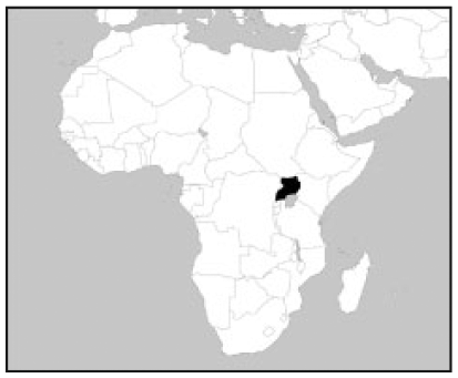
Kampala is Uganda’s capital city, with a population of nearly 1.75 million people,(6) but growing at a rate of 3.7 per cent annually.(7) Over 60 per cent of the population live in informal settlements.(8) Here, population growth, rural–urban migration, economic and industrial developments, urban agriculture, unclear boundaries, land ownership and the long-term failure of government regimes to enforce development control, among other factors, have resulted in extensive encroachment on the city’s wetland areas.(9) These wetlands are important because they drain and purify waste water from the city before discharging it into Africa’s largest freshwater lake, Lake Victoria.(10) The lake is not only the city’s main source of water but also a major “biodiversity hot-spot”.(11) In recent years, increased pollution of the lake has led to rising water treatment costs and hence increased the cost of water supply to the city. For example, by 2008, the monthly cost of treating water incurred by the National Water and Sewerage Cooperation (NWSC) had risen fourfold from the 1990s.(12)
b. Risks associated with encroachment on wetlands
Exposure to frequent flooding and waterlogging in Kampala has gradually increased as human activities advance further and further into the wetlands.(13) Recent studies in Kampala predict that as more areas get developed, the degree of imperviousness as well as surface runoff will increase, resulting in more flooding.(14) Although previous city plans considered wetlands as flood attenuation zones for the city,(15) the proposed Kampala Physical Development Plan seeks to transform most of the wetland area in the city into “lively, healthy and functional urban parks”, to be used as green open space, for recreation, sports and culture.(16) Currently, communities living in wetlands are exposed to a wide range of hazards and several vulnerability conditions. The damage caused by the hazards is diverse but mostly frustrates people’s livelihoods and lowers the quality of life.(17) Except for reviews of the causal mechanisms highlighted above, there are limited empirical data on local conditions that shape risk events in this context. Understanding the range of hazards, exposure, damage and perceived vulnerabilities is an important step in risk assessment and a foundation for risk reduction strategies.(18)
c. Theoretical basis for the study
This study draws theoretical insights from contemporary risk studies, including studies linked to climate variability. Most definitions of risk in literature point to the probability of occurrence of an (undesirable) event among vulnerable subjects.(19) Also, the disaster risk literature defines risk as a function of hazard factors and vulnerability factors, in addition to adaptive capacity, i.e. the ability to anticipate, resist, cope with, or recover from the effects of a hazard.(20) The interactions between the factors that constitute risk are often complex but have been simplistically incorporated into the risk equation.
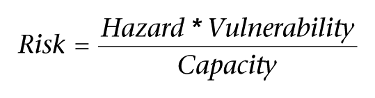
SOURCES: Adapted from Taubenböck, H, J Post, A Roth, K Zosseder, G Strunz and S Dech (2008), “A conceptual vulnerability and risk framework as outline to identify capabilities of remote sensing”, Natural Hazards and Earth System Sciences Vol 8, pages 409–420, available from http://www.nat-hazards-earth-syst-sci.net/8/409/2008/; Brooks, N (2003), “Vulnerability, risk and adaptation: A conceptual framework”, PhD thesis, Tyndall Centre for Climate Change, University of East Anglia, Norwich; and UNDP (2004), Reducing Disaster Risk: A challenge for development, United Nations Development Programme, New York, available at http://www.preventionweb.net/files/1096_rdrenglish.pdf.
From the above equation, it is clear that risk is hazard-specific, where “hazard” refers to a threatening event or potentially damaging phenomenon, for example a flood, fire, disease, etc. Vulnerability refers to the “conditions determined by physical, social, economic and environmental factors or processes which increase the susceptibility of a community to the impact of hazards”,(21) or intrinsic characteristics of a system, element or individual,(22) and should be considered in the context of the hazard characteristics in question.(23) The measurement of vulnerability is however still fuzzy(24) and difficult to express as a single metric. But vulnerability is uniquely perceived by those affected in the context of their circumstances and can be assessed through their perceptions.(25) The “perceived vulnerability” discussed in this paper is an intrinsic characteristic and is used as a proxy expression of vulnerability. It is based on the assumption that hazards interact with psychological, social, institutional and cultural processes in ways that may amplify or attenuate responses or perceptions of risk.(26)
We apply a critical realist perspective on urban environmental risk to examine the factors associated with perceived vulnerability. Critical realism assumes that risk events are shaped by causal mechanisms and specific local conditions.(27) In the context of this study, causal mechanisms could include population pressure, rural–urban migration, poverty and social–political processes, already highlighted above; local conditions could include location, seasonality, infrastructure, land use, tenure status, income levels, adaptation mechanisms and social–demographic factors, which have hitherto not been empirically analysed. Thus, besides exploring the range of hazards and damage, the paper analyses the factors associated with perceived vulnerability to a principal hazard: flooding.
II. Methods
a. Study setting, design and sampling
The study was done among communities living in four wetlands (Nakivubo, Kinawataka, Kansanga and Kyetinda/Ggaba) that drain into Murchison Bay of Lake Victoria (Figure 1), but was limited to the administrative boundaries of Kampala District. Quantitative and qualitative data were collected using a mix of methods: a household survey of 551 households, four focus group discussions (FGDs), five key informant interviews (KIIs), and GPS-linked field observations. The main outcomes of interest for the study were to establish the kind of hazards faced by communities living and/or working in Kampala’s wetlands and their perceived vulnerability to the hazards.
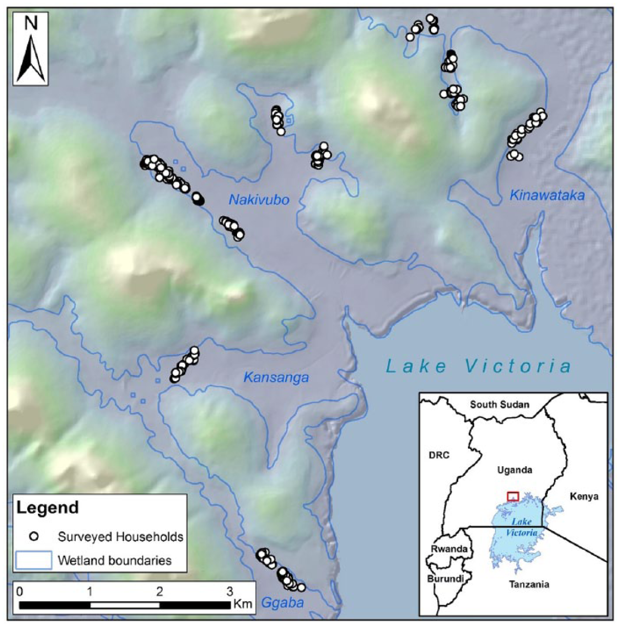
Map of the study area showing sampled households and wetlands in Kampala
Purposive sampling was done in five parishes (Butabika, Mutungo, Bukasa, Kansanga and Ggaba) that cover significant portions of the four wetlands. Although encroachment activities extend beyond informal settlements, the household survey was done in informal settlements located within wetland areas. Given the clustered and crowded nature of the informal settlements within the study area, selection of samples was based on approximated population sizes of the various clustered settlements and fell within the officially demarcated wetland areas (Figure 1).
b. Study tools and data collection
For the quantitative data, a household survey was conducted using semi-structured interviews, translated into the commonly spoken local language (Luganda). Research assistants were trained and the questionnaires were pretested in a comparable community in the Lubigi wetland, which was not included in the study. The questionnaires were designed to collect data on hazards experienced by the household and perceived frequency of exposure, damage caused by the hazards, and perceived vulnerability to hazards. In addition, data on socio-demographic and socioeconomic characteristics, such as gender, age, level of education, marital status, nature of tenure, length of stay in the area, household size, main occupation, monthly rent and household monthly expenditure, were collected. Where necessary, respondents were asked to rank their degree of agreement or disagreement with statements on Likert scales.
For the qualitative data, the four FGDs held were of male farmers, female farmers, homeowners/landlords and tenants, each group consisting of seven participants. Landlords owned rental housing units or occupied their own houses, while tenants occupied rented housing units in the area. The five key informants interviewed included two senior wetland officers from the Wetlands Department at the Ministry of Water and Environment (MWE); the Environment and Sanitation Specialist in the Directorate of Public Health and Environment at the Kampala Capital City Authority (KCCA); the Chairperson of the Nakivubo Farmers Association; and the Safety Manager for a non-governmental organization, Hope for Children, based in Namwongo, adjacent to the Nakivubo wetland. Qualitative data were collected using FGD and KII guides respectively.
c. Data management and analysis
Coded quantitative data were entered into EpiData 3.0 software, and cleaned and exported to SPSS 19 software for analysis. Frequencies and percentages were calculated to show exposures and perceived vulnerabilities to hazards. In order to establish the main factors associated with exposure and perceived vulnerability, binary logistic regressions were performed to generate crude odds ratios (CORs),(28) with 95 per cent confidence intervals (CIs), and statistical association was considered significant at p<0.05. The factors that were significant or near significance in bivariate analysis were incorporated into multivariate regression models to generate adjusted odds ratios (AORs), 95 per cent CIs and p-values. Qualitative data from voice recordings were transcribed and summarized into thematic issues of interest as they emerged and have been used to elaborate quantitative results in form of narratives or direct quotes where appropriate.
d. Ethical considerations
Ethical clearance for the study was obtained from Stellenbosch University, Makerere University, and the Uganda National Council for Science and Technology. Written consent was obtained from all participants, who also retained a copy. The data collected were handled confidentially.
III. Results
The results presented here include the social–demographic characteristics of respondents, an inventory of self-reported hazards and exposure frequency, damage or effects of floods and waterlogging, the factors associated with exposure to floods, perceived vulnerability, and the factors associated with perceived vulnerability to floods.
a. Social–demographic characteristics of respondents
Of the 551 respondents surveyed, 55.5 per cent were female, 67 per cent were aged 30 years or younger, 52.4 per cent had studied beyond primary level, 73.9 per cent were married/cohabiting, 63 per cent were tenants (renting), and 65.7 per cent had lived in the area for at most five years, as detailed in Table 1. The mean household size was 3.9 (SD=2), ranging from 1–13 people per household.
Characteristics of respondents
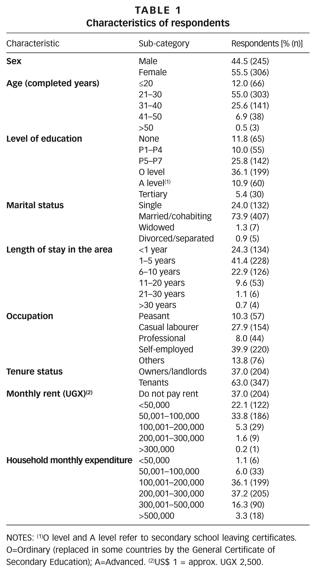
NOTES: (1)O level and A level refer to secondary school leaving certificates. O=Ordinary (replaced in some countries by the General Certificate of Secondary Education); A=Advanced. (2)US$ 1 = approx. UGX 2,500.
b. Hazards and exposure
Respondents were asked to mention the hazards their household faced in the area. In order to minimize recall bias, the exposure period was limited to one year preceding the study. With reference to each hazard mentioned, respondents were further asked whether they were exposed to the hazard often or rarely. Results summarized in Table 2 show that disease vectors, communicable diseases, floods and waterlogging, vermin, dampness and poor excreta disposal top the list, and the majority of households were often exposed to them. Next is crime, to which a fairly large proportion of households were also often exposed. Other hazards to which more than half or so of households mentioned frequent exposure are pollution, evictions and subsidence/collapsing of houses. A small proportion of respondents mentioned fires as a hazard, the majority of whom said it was rare.
Hazards and perceived exposure
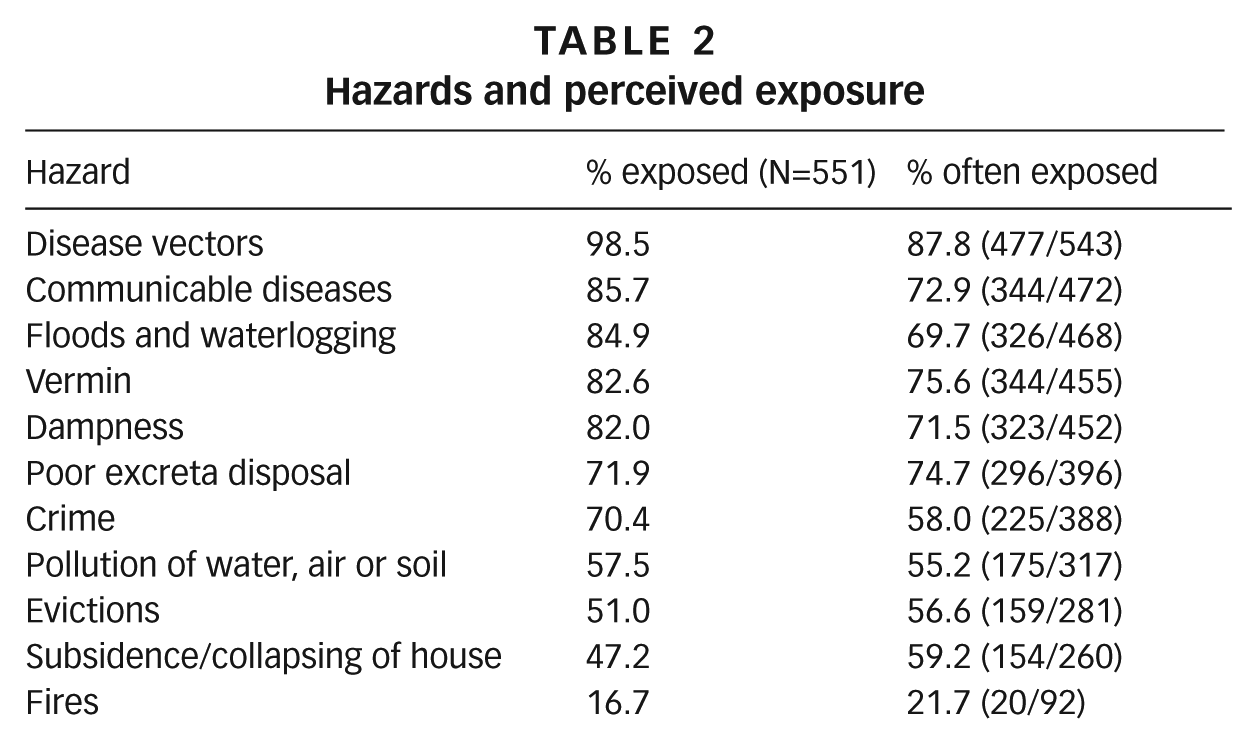
Although floods and waterlogging were not experienced as often as disease vectors, vermin, poor excreta disposal, dampness and communicable diseases, they were said to play a central role in the proliferation of most of the other hazards. Furthermore, it was mentioned that during heavy rains, some people empty their latrines into tertiary drains, while others dump solid waste and most frequently also plastic bottles to be swept away by stormwater (Box 1).
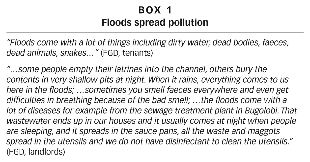
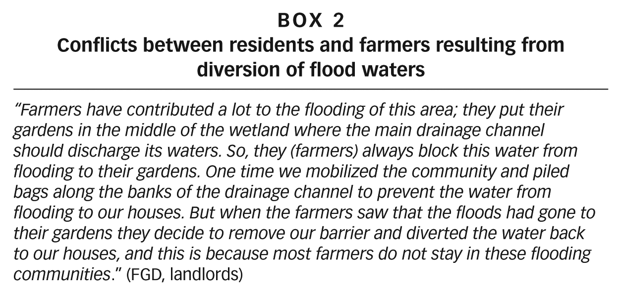
In addition to the hazards mentioned above, several other related issues were mentioned such as illegal and restrictive electricity connections, conflicts between residents and farmers resulting from diversion of flood waters (Box 2), frequent clogging of drainage channels, insecurity, noise from bars and nightclubs, and investors.
c. Effects of floods and waterlogging
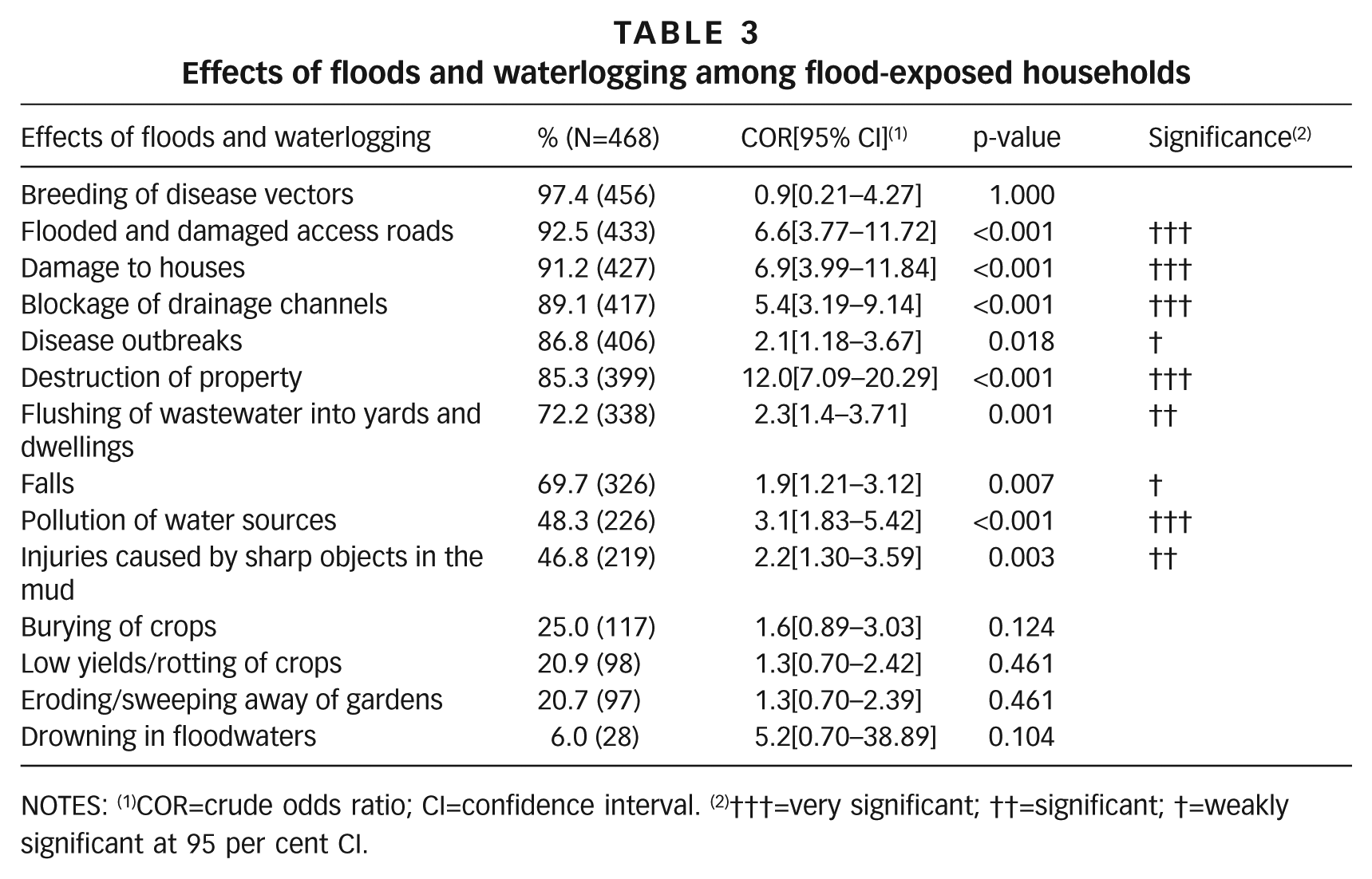
The effects of floods and waterlogging on flood-exposed households (Table 3) were examined by running independent bivariate analyses. Although breeding of disease vectors was the most common effect, it was not significantly different between households that had been exposed to floods and those that had not.
Effects of floods and waterlogging among flood-exposed households
NOTES: (1)COR=crude odds ratio; CI=confidence interval. (2)†††=very significant; ††=significant; †=weakly significant at 95 per cent CI.
Flooded and damaged access roads, damage to houses, blockage of drainage channels, disease outbreaks, destruction of property, flushing of wastewater into yards and dwellings, falls, pollution of water sources, and injuries caused by sharp objects in the mud were more likely to be reported among flood-exposed households than those that had not been exposed to floods.
It was noted in all the FGDs and KIIs that floods and waterlogging provided breeding sites for mosquitoes and flies, kept houses damp and structurally compromised, and polluted the area. Dampness of houses was said to be associated with upper respiratory tract complications (FGD, tenants).
Solid waste and silt washed down by stormwater clog drainage channels, triggering flooding. Flooding was said to be a problem in the rainy seasons, although several of its effects were often experienced far beyond rainy seasons. Some community members believed that floods are channelled to their settlements intentionally by government as an indirect way of evicting them.
Through observations during transect walks, several of the hazards and vulnerabilities mentioned by participants were confirmed (Figure 2).
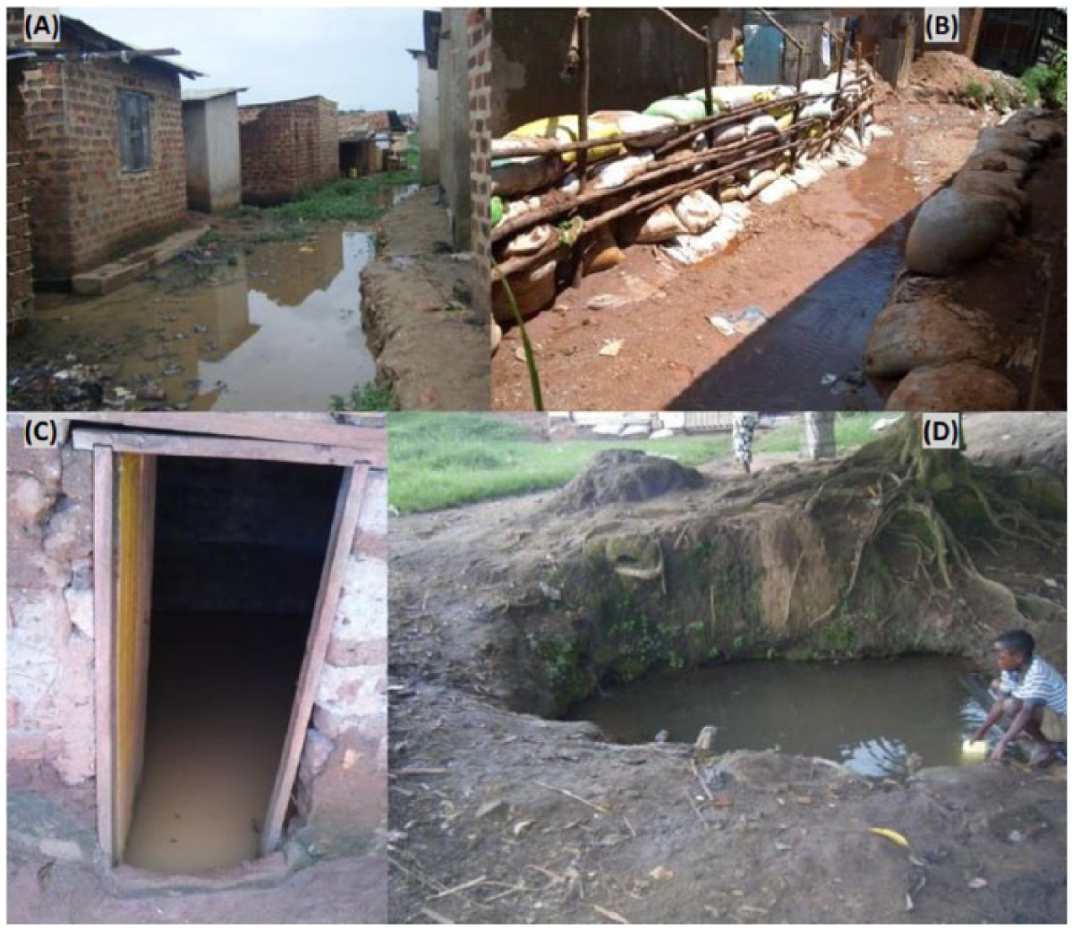
Flooding situation in the flat and low-lying study area: (A) flooded access paths; (B) flood barriers made of sandbags; (C) flooded house; and (D) unprotected well prone to contamination
d. Factors associated with exposure to floods
Factors associated with exposure to floods were examined among flood-exposed households at bivariate and multivariate levels (Table 4). Tenants were more likely to be exposed to floods than homeowners/landlords (COR 1.7, 95% CI, 1.08–2.76); households that spent more than UGX 200,000 (US$ 80) per month were less likely to be exposed to floods than households that spent less (COR 0.6, 95 per cent CI, 0.33–0.91). Factors such as marital status, occupation, length of stay in the area, and family size were not statistically associated with exposure to floods.
Factors associated with exposure to floods and waterlogging
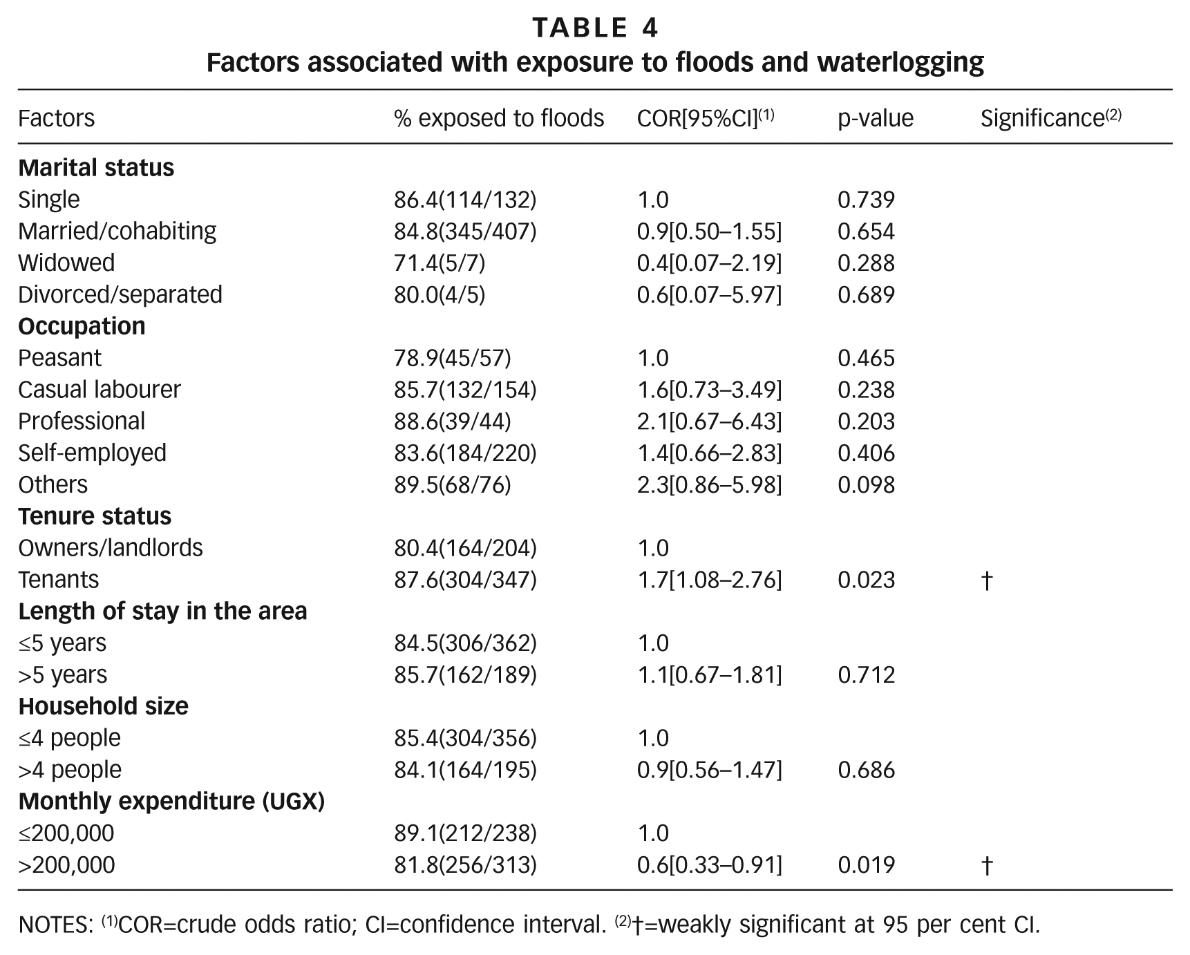
NOTES: (1)COR=crude odds ratio; CI=confidence interval. (2)†=weakly significant at 95 per cent CI.
Some community members believed that the government was not doing enough to ensure their safety and wellbeing.
“The government should construct the drainage channel; …the government should reconstruct that bridge and put bigger culverts to eliminate the flooding; … the government should get organizations to sensitize people on how to create income generating activities; ….government should provide us with 2-3 mosquito nets per household.” (All four FGDs)
e. Perceived vulnerability to hazards
Respondents were asked to rank on a Likert scale how they perceived their household’s vulnerability to each of the hazards that they had already mentioned. The scale provided four options: “very safe”, “not vulnerable”, “fairly vulnerable” and “very vulnerable”. The results (Figure 3) show that the majority (81.1 per cent) of respondents perceived their households as very vulnerable to disease vectors, while more than half (53.4 per cent) considered themselves very vulnerable to floods and waterlogging. Nearly half ranked their households as very vulnerable to poor excreta disposal, dampness and communicable diseases (47.4 per cent, 46.1 per cent and 46.1 per cent respectively), while more than half (55.5 per cent) of respondents ranked their households as fairly vulnerable to pollution of water, air and/or soil.
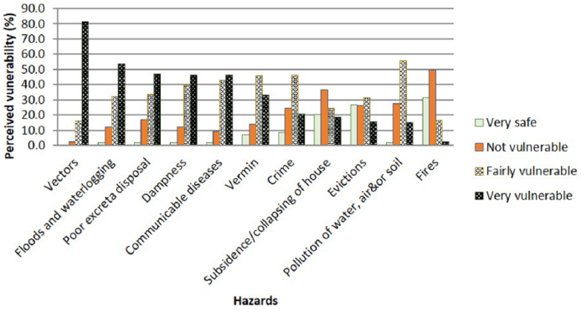
Ranked perceived vulnerability to hazards
The four categories above were collapsed into two by adding “very safe” to “not vulnerable”, and “fairly vulnerable” to “very vulnerable” (Figure 4). Disease vectors, communicable diseases and dampness, said to be secondary effects of flooding, were perceived by over 80 per cent of respondents. Also, poor excreta disposal (e.g. shallow/filled-up pit latrines), vermin and pollution were said to be linked to flooding, waterlogging and the high water table.
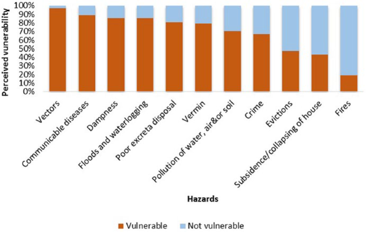
Combined perceived vulnerability to hazards
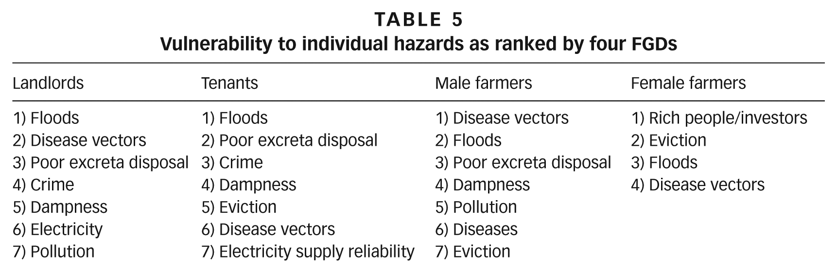
In each of the four FGDs (i.e. landlords, tenants, male farmers and female farmers), participants were asked to list and rank hazards according to the number of people affected, which was then used as a proxy measure for vulnerability (Table 5). Landlords and tenants ranked floods first; male farmers ranked disease vectors first, yet female farmers ranked disease vectors last.
Vulnerability to individual hazards as ranked by four FGDs
f. Factors associated with perceived vulnerability to floods
Bivariate and multivariate logistic regression analyses were run to assess factors associated with perceived vulnerability to floods and waterlogging. Tenure status and exposure to floods and waterlogging were significant at the bivariate level of analysis (Table 6). Tenants were more likely to perceive their households as vulnerable to floods and waterlogging than homeowners/landlords (COR 1.7, 95 per cent CI 1.03–2.68), while households that had been exposed to floods before were more likely to perceive themselves as vulnerable to floods and waterlogging than households that had not been exposed (COR 34.8, 95 per cent CI 18.95–63.92). Other factors such as sex, age, marital status, occupation, length of stay in the area, family size and monthly expenditure were not statistically significant.
Factors associated with perceived vulnerability to floods and waterlogging
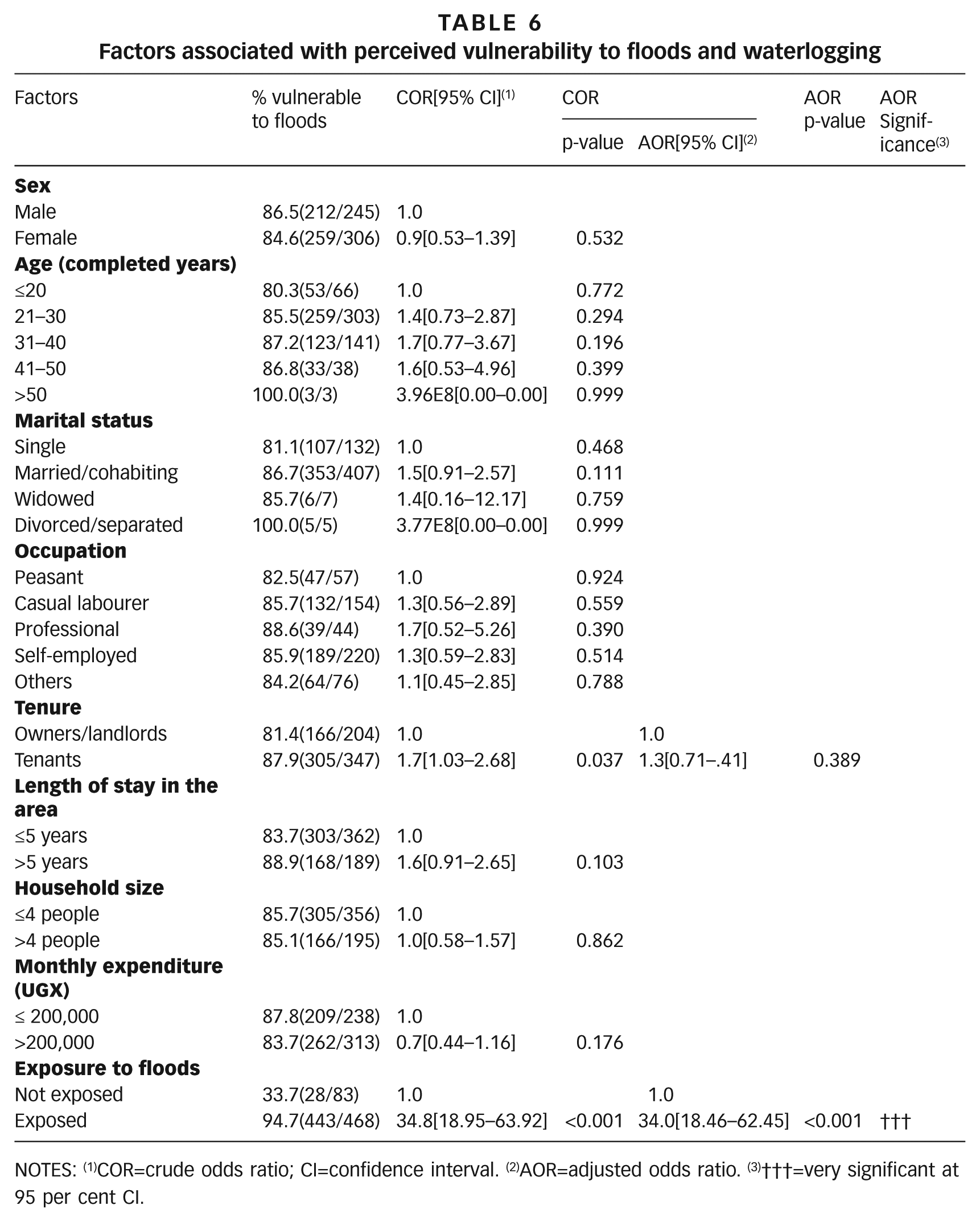
NOTES: (1)COR=crude odds ratio; CI=confidence interval. (2)AOR=adjusted odds ratio. (3)†††=very significant at 95 per cent CI.
Multivariate analysis showed only one factor, exposure to floods and waterlogging, to be statistically significant. Households that had been exposed to floods before were more likely to perceive themselves as vulnerable to floods and waterlogging than households that had not been exposed (AOR 34.0, 95 per cent CI 18.46–62.45).
IV. Discussion
a. Floods and public health
Overall, analysis of exposure to hazards showed floods and waterlogging to be the principal hazard. However, secondary effects of floods and waterlogging such as disease vectors (especially mosquitoes), communicable diseases and dampness affect more people than the actual floods. This is in line with findings from previous research on climate change-related flooding, which point out the secondary impacts of flooding on health and livelihoods.(29) Waterlogged areas provide breeding sites for mosquitoes that spread malaria.(30) The increased frequency of flooding and mosquito breeding have been reported as key concerns for wetland communities around Lake Victoria in Kenya,(31) and also as an explanation for the upsurges of malaria in Kampala.(32) However, it is also likely that the agricultural activities in the wetland, particularly the method of farming and the type of crops grown, could provide breeding sites for mosquitoes.(33)
The nature of flooding experienced in the study area can be categorized as seasonal flash floods, resulting from intense short-duration thunderstorms. The impact of floods occurring in the area is exacerbated by human activities such as the built-up areas, blocked storm drains and culverts, compacted ground, the relatively flat profile of valleys and the high water table in lowlands, which limits percolation. The floods range from short-term to prolonged, depending on location (short-term in the wetland peripheries and prolonged in the lower and permanently inundated parts). Footpaths between buildings become waterlogged whenever it rains, as has been observed in other low-lying informal settlements in several African cities.(34) With this complex sanitation situation, decomposing waste provides breeding grounds for flies; water sources, usually shallow wells and spring wells, are frequently contaminated by floods; and a host of water and sanitation-related diseases spread far beyond flood-prone areas.
b. Vulnerability in flood-prone areas
Occupation of flood-prone areas happens in dry seasons, and as such, the population there is highly transient.(35) Results indicate that perceptions of vulnerability to floods and waterlogging were associated with previous exposure to the same, i.e., households that had been exposed to floods were more likely to perceive themselves to be vulnerable. In addition, the vulnerabilities ranked in Table 5 suggest that gender is an important factor for perceptions of vulnerability. The rankings show that female farmers perceived themselves as more vulnerable to being displaced or evicted than their male counterparts. This is possibly due to culturally embedded gender inequalities and property rights, as have been reported in other studies.(36) Otherwise, the variations in perception of vulnerability could be attributed to differences in adaptive capacity, increases in flood frequency and severity, or a combination of the above.
In spite of the high risk of flooding, communities continuously endure and occupy these wetland areas for various reasons, such as poverty, population pressure, benefits they associate with the area, etc. Studies on flooding in informal settlements have reported several coping strategies including seasonally occupying dwellings, sleeping on raised beds, keeping valuables above ground, building resilient houses and flood barrier walls, raising embankments, raising latrines, desilting drainage channels, digging drainage around the house, adopting psychosocial coping strategies such as alertness, using early warning systems, relying on social networks, utilizing insurance, and lobbying for external support, e.g. from government/politicians or third party actors.(37) Such coping strategies minimize vulnerability. There is therefore a need to explore the coping strategies or adaptation mechanisms developed in response to the various hazards identified in this study.
The nature of tenure was crudely associated with both exposure and vulnerability to floods and waterlogging. Tenants were more likely to be exposed and/or perceive themselves more vulnerable to floods than landlords/homeowners. This is possibly due to the fact that homeowners have invested in making their dwellings safer, which tenants do not have a mandate to do. In addition, houses in flood-prone areas are cheaper for tenants, hence are usually on demand in dry seasons. Studies analysing the pattern of growth for Kampala have reported that large parts of the newly built-up areas, especially informal settlement areas, are located in wetlands.(38) This could be because plots in the wetlands are cheaper and many owners would rather sell to a willing buyer or rent out to tenants than continue being flooded.
c. Lessons for environmental protection and risk reduction
The community places trust in the government to ensure a clean and healthy environment,(39) but there are sentiments that the government is not doing enough to ensure the safety and wellbeing of its people. However, it is not uncommon for vulnerable communities to blame their governments for not doing enough to guarantee their safety.(40) It should be noted here that not all the hazards mentioned by the community satisfy the conventional definition of a hazard in literature. Most of what the community perceives as hazards have more to do with the local environmental sanitation conditions. Environmental sanitation encompasses excreta and waste management, safe water management and hygiene, drainage and vector control. The local authority, in this case KCCA, should normally provide such services. However, servicing informal communities, which are occupying gazetted wetland areas (areas required for resettlement), would imply not only formalizing the informal but also legalizing the illegal. The local authority would be acting contrary to its own planning. Nonetheless, these findings underpin the importance of environmental sanitation and re-emphasize the necessity for an integrated approach(41) in dealing with the issues of population growth, health and the environment.
V. Conclusions
This paper has unveiled the various hazards, damage caused by the hazards, and locally perceived vulnerabilities among communities living and/or working in Kampala’s wetlands. The findings are contextual, as experienced and perceived by the affected communities. Although the community is exposed to several hazards, principal among them is seasonal flooding and waterlogging, whose secondary effects such as vector breeding and disease outbreaks affect more people than just those exposed to floods. Environmental protection and risk reduction can have competing interests; as such, interventions on either side need to be integrated. The variations in exposure to hazards and perceived vulnerabilities observed in this study could be due to differences in capacity to resist, cope, or adapt to minimize vulnerability. An investigation of mechanisms for adaptation to the various hazards identified in this paper would enrich understanding of the elements that shape risk in this context.