
Abstract
This paper discusses benefits that informal wetland communities in Kampala, Uganda derive from their location in the wetland and how they adapt to minimize vulnerability to hazards such as floods and disease vectors. We focus on the mechanisms, preferences and ability to adapt. A total of 551 households were interviewed in addition to four focus group discussions and five key informant interviews. Free water from spring wells and cheaper rental units topped the benefits from location, while the main benefit associated with the wetland is that it supports crop farming. Tenure status was significantly associated with the preference and perceived ability to adapt: tenants were less likely to prefer to adapt, and less likely to perceive themselves as able to afford adaptation, than landlords. There is a need for coordinated adaptation strategies that involve all stakeholders and that enhance equitable utilization of wetland resources without compromising their ecosystem services and economic benefits.
I. Introduction
As the world becomes more urbanized, governments in developing countries are grappling to find equilibrium between poverty reduction and environmental protection. The past couple of decades have witnessed unprecedented encroachment on marginal and reserve areas such as wetlands and increasing exposure of vulnerable groups, especially the urban poor, to hazards.(1) Often, the poor are most affected because they directly depend on their immediate environment for livelihoods. Only resilient communities can thrive.(2) Resilience has been defined from a number of perspectives, but its key elements include the ability of a social-ecological system to absorb disturbance, learn from it, and appropriately reorganize and adapt to minimize vulnerability.(3) The intricate interaction between the social and natural components of our environment necessitates in-depth understanding of the factors that shape the way in which risk is perceived or experienced. Alberti(4) holds that “humans depend on earth ecosystems for food, water, and other important products and services”, and that “changes in ecological conditions that result from human actions in urban areas ultimately affect human health and well-being”.
Wetlands have been well documented for their ability to purify and gradually release water, thereby controlling floods and providing water. While the ecological importance of wetlands is clear, for the purpose of human habitation, wetlands are high-risk areas, prone to flooding, pollution and other sanitation-related hazards.(5) Despite the hazards, however, the fertile soils and abundant soil moisture in wetlands support crop farming almost throughout the year in many parts of the world, guaranteeing food security(6) and subsistence incomes for the poor, among other benefits.(7) In order to exploit these benefits, minimize vulnerabilities and improve quality of life, communities devise adaptation mechanisms against the hazards they face. However, in the process of adapting, human activities can potentially degrade wetlands, compromise their ecological benefits, or create even more hazards.
The government of Uganda envisions managing and wisely using wetland resources in ways conducive to conserving the environment and its biodiversity while optimizing sustainable benefits. Among its objectives, Uganda’s Wetland Sector Strategic Plan seeks to promote community-based regulation and administration of wetlands resource use.(8) The dilemma, however, lies with implementing wetland conservation in the framework of Uganda’s Poverty Eradication Action Plan, whose pillars include increasing the ability of the poor to raise their incomes, and improving quality of life for the poor. The National Environment Act’s Section 36, which provides for protection of wetlands, prohibits any person from reclaiming, erecting or demolishing any structure(9) that is fixed in, on, under or over any wetland. In August 2015, the Ministry of Water and Environment launched a wetland atlas for Kampala and neighbouring districts of Wakiso and Mukono in a bid to raise awareness, following a cabinet directive to cancel illegal land titles in wetlands and evict encroachers.(10) Also, a memorandum of understanding has been signed by the National Environmental Management Authority, the Kampala Capital City Authority (KCCA) and the Ministry of Water and Environment, which has intensified the pressure to evict wetland encroachers. Despite these measures, however, more than half of the wetland area in Kampala has been transformed into crop fields, industrial establishments and settlements.(11)
The city is built on gentle hills and flat-bottomed valleys,(12) with a network of wetlands covering approximately 32 km2, which is about 16 per cent of Kampala District.(13) Here, many informal settlements, occupied by a mix of tenants and landlords,(14) have cropped up, alongside efforts to reclaim wetlands for crop farming and industrial development. Traditional farmers (peasants) and rural–urban immigrants engage in urban agriculture in the wetlands as a transfer of rural livelihood strategies into an urban environment, where a market for produce is assured and transport costs are minimal. Cultivation in Kampala’s wetlands has been reported as far back as the 1950s but increased significantly in the 1990s.(15) The farmers mostly plant sugarcane and cocoyam, which thrive well in waterlogged soils.(16)
In this paper, we are interested in the opportunities/benefits and community-level adaptations in wetlands that receive and filter wastewater from the city of Kampala, Uganda, before discharging it into Murchison Bay in Lake Victoria. Increased occupancy of these flood-prone lands is associated with increased vulnerabilities and risks.(17) It is important to understand how communities that derive benefits from the wetlands exploit these benefits, and how they adapt in order to minimize their vulnerability. This is necessary not only for risk reduction in these communities, but also for the judicious use of wetland resources. This paper discusses survey findings from informal wetland settlements in Kampala. The discussion centres on the benefits that communities associate with their location and the wetland itself, adaptation mechanisms they employ to minimize vulnerability to disease vectors and floods, and the factors associated with the preference to adapt (rather than relocate) and their perceived ability to afford adaptation.
II. Methods
a. Study setting, design and sampling
This cross-sectional study was conducted among communities living in four wetlands (Nakivubo, Kinawataka, Kansanga and Kyetinda/Ggaba) that drain into Murchison Bay of Lake Victoria in Kampala (Map 1). The study population inhabited informal settlements in wetlands, most of which were within a radius of eight kilometres from the city centre. A mix of qualitative and quantitative methods, including four focus group discussions (FGDs), five key informant interviews (KIIs), GPS-linked field observations and a household survey, were used to gather data. The study investigated benefits and opportunities that the community associated with their location and those derived from the wetland. In addition, community-level adaptation mechanisms to minimize vulnerability to hazards and also to exploit benefits and opportunities were assessed. We applied purposive sampling in five parishes, Butabika, Mutungo, Bukasa, Kansanga and Ggaba, which cover significant portions of the four wetlands. Study units were households, and were selected proportionate to population sizes of zones in the wetland areas.
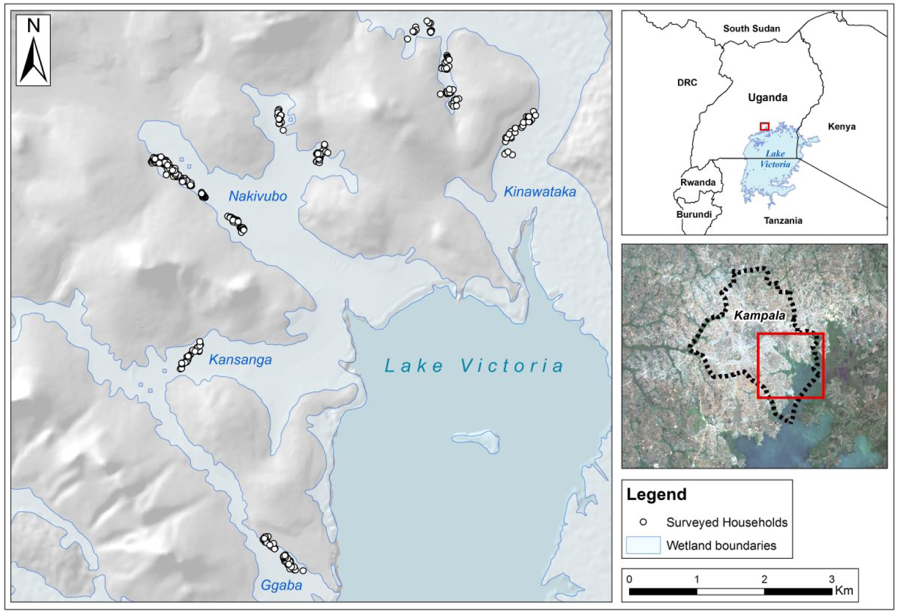
Study area, including sampled households and wetlands in Kampala
b. Data collection and quality control
Quantitative data from the survey of 551 households were collected using structured interviews that were administered by trained and experienced research assistants. One respondent was interviewed per household, either the household head or an adult household member found at home at the time of the visit. To ensure good-quality data, the questionnaires were drafted in both English and the local language (Luganda), and research assistants were trained in administering both. The questionnaires were pre-tested in a comparable community that was not part of our study area. The feedback from the pre-test was used to make necessary adjustments in the questions to attain coherence, validity and relevance. To ensure completeness, accuracy and consistency in responses, data were cross-checked and edited in the field. Besides collecting demographic and socioeconomic characteristics of respondents, the questionnaires inquired about the benefits and opportunities respondents associated with their housing location and the benefits they derived from the wetland, adaptation mechanisms to minimize vulnerability, and the preference and ability to adapt.
To gain insights into the likelihood of flood-exposed households adapting in a particular manner to minimize vulnerability to floods and waterlogging, each adaptation mechanism practised by a household was independently regressed against self-reported exposure to floods and waterlogging. And to gain insights into the factors associated with the preference to adapt to floods and waterlogging rather than relocating to another place, respondents were asked whether they preferred to stay and adapt or to relocate to another place. Respondents were also asked whether they could afford to adapt to the hazards that they faced in this area.
To complement the quantitative data, qualitative data were gathered through the four focus group discussions (FGDs) of seven participants each, the five key informant interviews (KIIs) and GPS-linked field observations. The four FGDs were conducted with house owners/landlords, tenants, male farmers and female farmers. House owners have invested in these vulnerable areas and are therefore at risk of loss in the event of hazards such as floods; tenants occupying rental housing units in the area constitute the majority of residents and are the most vulnerable; and farmers use the largest portion of the wetlands for crop cultivation. FGDs were held with male and female farmers separately because of the culturally embedded gender roles and inequality in land rights.(18) In the areas where the study was conducted, men customarily have more rights over land even though women are more engaged in cultivation.(19) The five KIIs were held with representatives of key stakeholders including the Wetlands Management Department at the Ministry of Water and Environment, the Directorate of Health and Environment at the Kampala Capital City Authority, Hope for Children (an NGO working to promote public health and the environment in the study area), and the Nakivubo Farmers Association.
c. Data management and analysis
Quantitative data were entered and cleaned in EpiData version 3.0 and subsequently exported and analysed in SPSS version 19. Frequencies and percentages were computed for discrete and categorical variables such as sociodemographic characteristics, benefits and adaptation mechanisms, and mean and standard deviation for household size. Ranked data were collapsed into binary data before performing regression analyses. Binary logistic regressions were performed at bivariate and multivariate levels to generate crude and adjusted odds ratios respectively, as well as 95 per cent confidence intervals and p-values. A chi-square test was used to test null hypotheses, and statistical significance was considered at p-value<0.05. Only variables that were significant at the bivariate level were included in multivariate regression. The outputs of the quantitative analysis are summarized in graphs and tables in the results section. Qualitative data from the recordings of FGDs and KIIs were transcribed. The data were then grouped into themes in line with study objectives and used to elaborate on quantitative findings in the form of narratives or direct quotes where necessary.
III. Results
a. Sociodemographic characteristics
Of the 551 respondents surveyed, 55.5 per cent were female, 67 per cent were between 18 and 30 years old, 52.4 per cent had studied beyond primary level, 73.9 per cent were married/cohabiting, 63 per cent were tenants (renting), and 66.4 per cent had lived in the area for less than five years. Household income, expenditure, monthly rent and occupation are summarized in Figure 1. The mean household size was 3.9 (standard deviation=2), and ranged from 1 to 13 people per household.
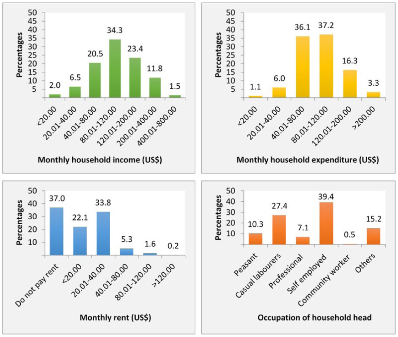
Household income, expenditure, rent and occupation
b. Benefits associated with housing locations
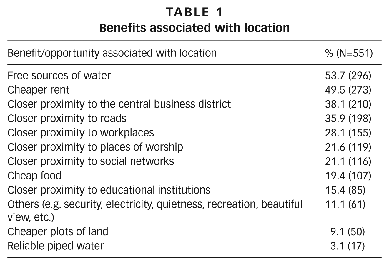
Households were asked about the benefits they derived from their location. More than half mentioned free sources of water (e.g. spring wells) and about half mentioned cheaper rents than in neighbourhoods that are not flood-prone. A significant proportion mentioned closer proximity to the central business district (CBD), roads, workplaces, places of worship, and social networks than in the suburbs (Table 1). Only 3.1 per cent mentioned reliable piped water.
Benefits associated with location
Although the house rent in these fragile areas is lower than in non-flood-prone neighbourhoods, it was reported to increase with proximity to urban centres and/or road networks.
“…some landlords mistreat us by increasing rent almost every month because they know their houses are near town, you will not go away and rent in other places which are a distance from town” (FGD, tenants).
Staying closer to workplaces, markets and urban centre was a strategic choice for residents to save on transport costs.
“…we are near industrial area we easily get jobs and we don’t pay for transport” (FGD, tenants).
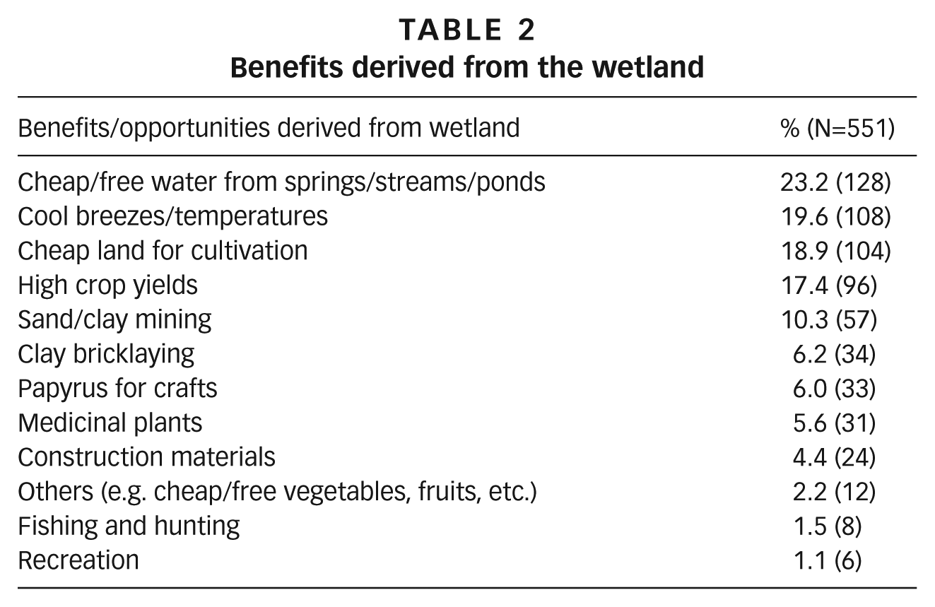
c. Benefits derived from the wetland
Besides the benefits associated with or derived from their residential location, households were also asked about benefits derived from the wetland area. Results in Table 2 show that free sources of water topped the list, followed by cool breezes/temperatures, cheap land for cultivation, high crop yields, and sand/clay mining. Only a few households mentioned fishing and hunting. Mudfish, which according to earlier occupants was an easy meal, can now hardly be found in the Nakivubo wetland. Recreation was mentioned least often.
Benefits derived from the wetland
Some of the benefits the community mentioned are illustrated in Photos 1A, 1B, 1C and 1D. The photos show cheaper plots for construction, free water from spring wells, an extensive sugarcane plantation, and clay and sand mining.
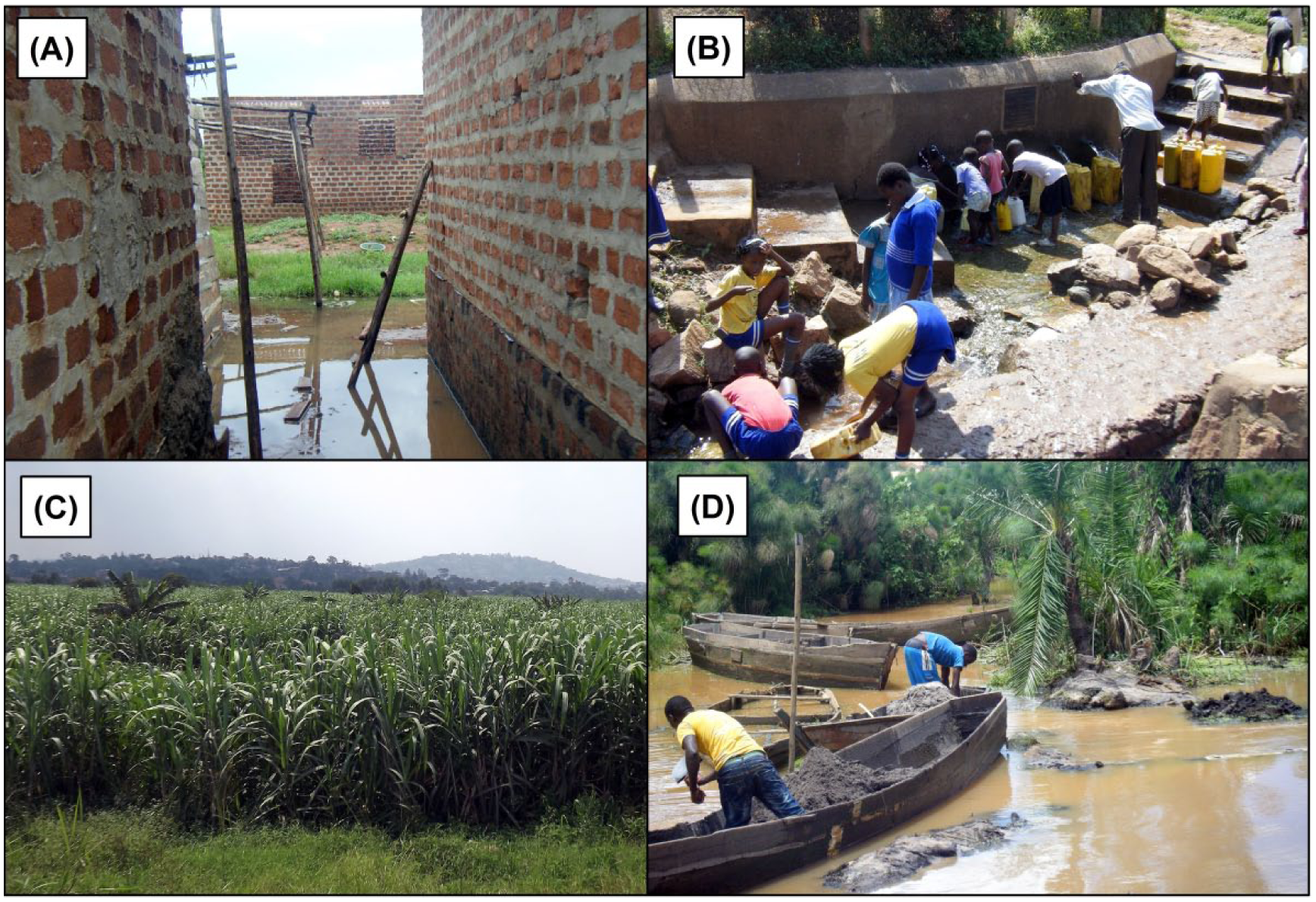
Some of the benefits from wetlands in Kampala: (A) cheaper plots, (B) free water, (C) farmland, and (D) clay and sand mining
d. Adaptation to hazards
Foremost among the hazards experienced and reported by respondents to the household survey were the presence of disease vectors (98.5 per cent) and floods and waterlogging (84.9 per cent).(20) Local adaptation mechanisms to minimize vulnerability to these hazards were examined. These results are presented in the subsequent sections.
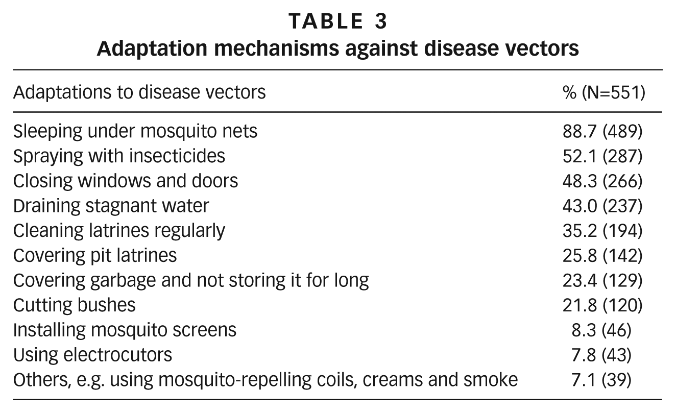
Adaptation mechanisms to minimize vulnerability to disease vectors
The majority of households mentioned adaptations to the hazard of malaria-transmitting mosquitoes, i.e. sleeping under mosquito nets and spraying with insecticides. Fewer households mentioned adaptation to the hazard of flies, i.e. cleaning latrines regularly, covering pit latrines, and covering garbage and not storing it for long, as summarized in Table 3.
Adaptation mechanisms against disease vectors
Adaptation mechanisms to minimize vulnerability to floods and waterlogging
A large majority of flood-affected households said they adapted by raising flood barriers, and a considerable majority adapted by building resilient structures. About two-thirds said they adapted by filling with soil to raise ground levels, placing valuables above the floor, and digging trenches around the house, while slightly more than half adapted by desilting drainage channels. These data are summarized in Table 4.
Adaptation mechanisms against floods and waterlogging among flood-affected households
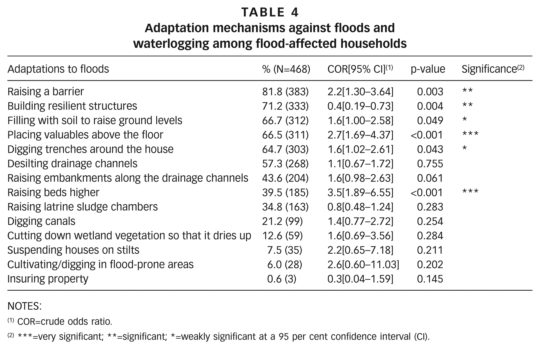
NOTES:
COR=crude odds ratio.
***=very significant; **=significant; *=weakly significant at a 95 per cent confidence interval (CI).
The results of regressions, also in Table 4, show that households that had been directly exposed to floods and waterlogging within the last five years were more likely than households that had not been exposed to floods to adapt by raising barriers around their houses (crude odds ratio (COR) 2.2, 95 per cent confidence interval (CI) 1.30–3.64, p=0.003); filling waterlogged areas with soil (prior to building or inside existing houses) to raise ground levels (COR 1.6, 95 per cent CI 1.00–2.58, p=0.049); digging trenches around the house (COR 1.6, 95 per cent CI 1.02–2.61, p=0.043); raising beds higher (COR 3.5, 95 per cent CI 1.89–6.55, p<0.001); and placing valuable items higher above ground (COR 2.7, 95 per cent CI 1.69–4.37, p<0.001).
Although a considerable majority of households said they had built resilient structures, the odds of building such resilient structures were significantly lower among flood-exposed households than among those that had not been exposed. It is likely that some households were exposed to floods earlier, then built resilient structures, which partly explains the high percentage of people with resilient structures among the flood-exposed, while the odds ratio of 0.4 could be because resilient structures are protective against floods and waterlogging. However, this being a cross-sectional survey, we could not establish a cause–effect relationship. While building resilient structures might be protective against exposure to floods, other factors such as location, severity of floods, and construction materials could affect the level of protection. Although several households exposed to floods and waterlogging also adapted by raising latrine sludge chambers, desilting drainage channels, raising embankments along the drainage channels, digging drainage canals, cutting down wetland vegetation so that the area would dry up, and cultivating/digging in flood-prone areas, these adaptations were often at neighbourhood scale, and were not statistically different between flood-exposed and unexposed households.
The nature and scale of adaptation mechanisms against floods and waterlogging varied widely from physical structures and innovations to practices and behavioural adjustments (such as staying awake at night to watch over family members during floods). Some of the physical adaptation mechanisms observed during the survey shown in Photos 2A, 2B, 2C and 2D include sandbags piled to form embankments along banks of drainage channels, bridging of streams to improve accessibility, barrier walls around property, and raised ground levels.
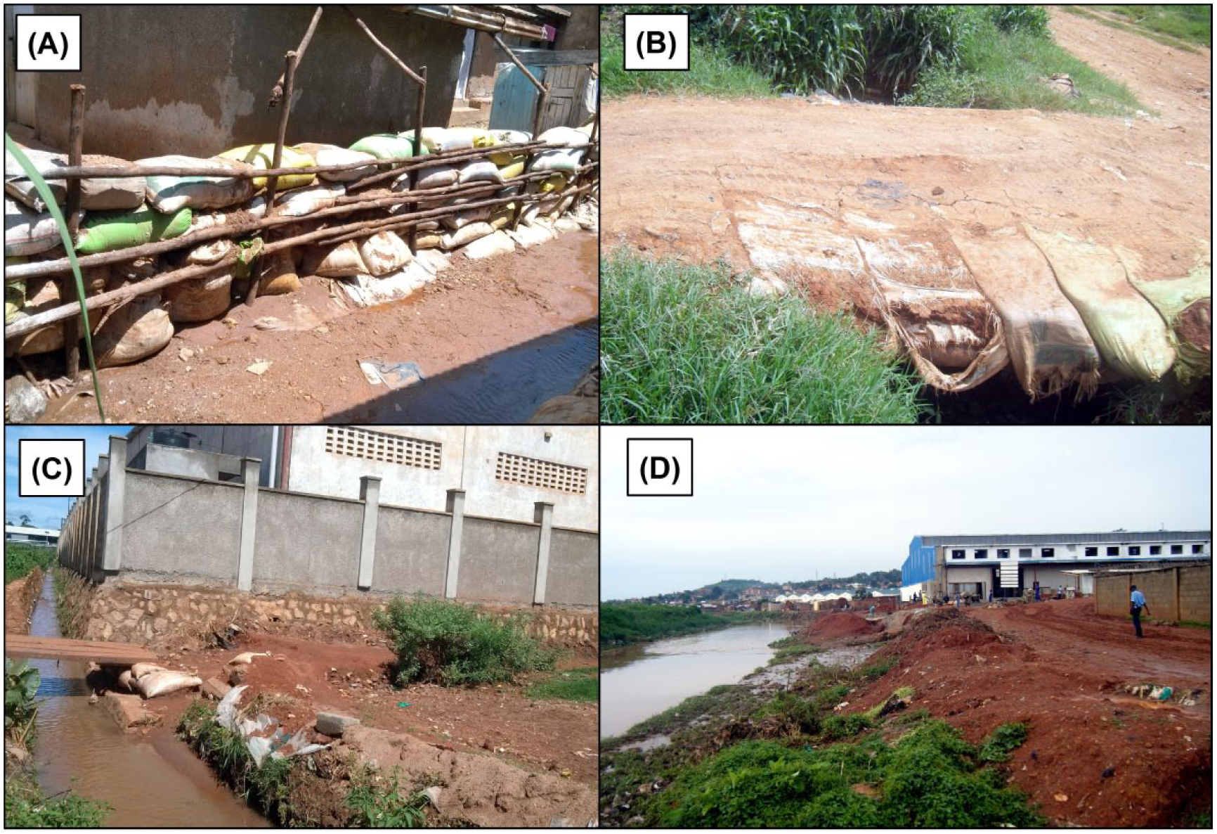
Some of the adaptations mechanisms against floods in the city of Kampala: (A) embankments along drainage channels, (B) locally innovated bridge across a stream, (C) barrier wall around property, and (D) marsh filling with earth to raise the ground above flood level
Some of the coping strategies were reported to be quite stressful and significantly lowered the quality of life for those affected.
“…I have spent three nights standing because of floods” (FGD, tenants). “…at night when I am sleeping and I hear the thunderstorm I get worried and I wonder where I will put the children at that time” (FGD, landlords). “…because one time the rain came when the parents were sleeping, children were sleeping on the floor, but by the time they [the parents] realized that the floods had entered the house, one child had already died” (FGD, landlords).
e. Preference to adapt to floods as opposed to relocation
Overall, about 35.6 per cent (196/551) of households said that, given the choice, they would rather stay in the wetland and adapt to hazards than relocate to somewhere else. The results of regressions presented in Table 5 show that occupation, tenure status, family size, exposure to floods, and perceived vulnerability to floods were significantly associated with the preference to adapt at the bivariate level. Multivariate analysis however revealed that only tenure status was significantly associated with the preference to adapt: tenants were less likely to prefer to adapt (adjusted odds ratio [AOR] 0.3, 95 per cent CI 0.20–0.44, p<0.001) than house owners/landlords.
Factors associated with the preference to adapt to floods as opposed to relocation
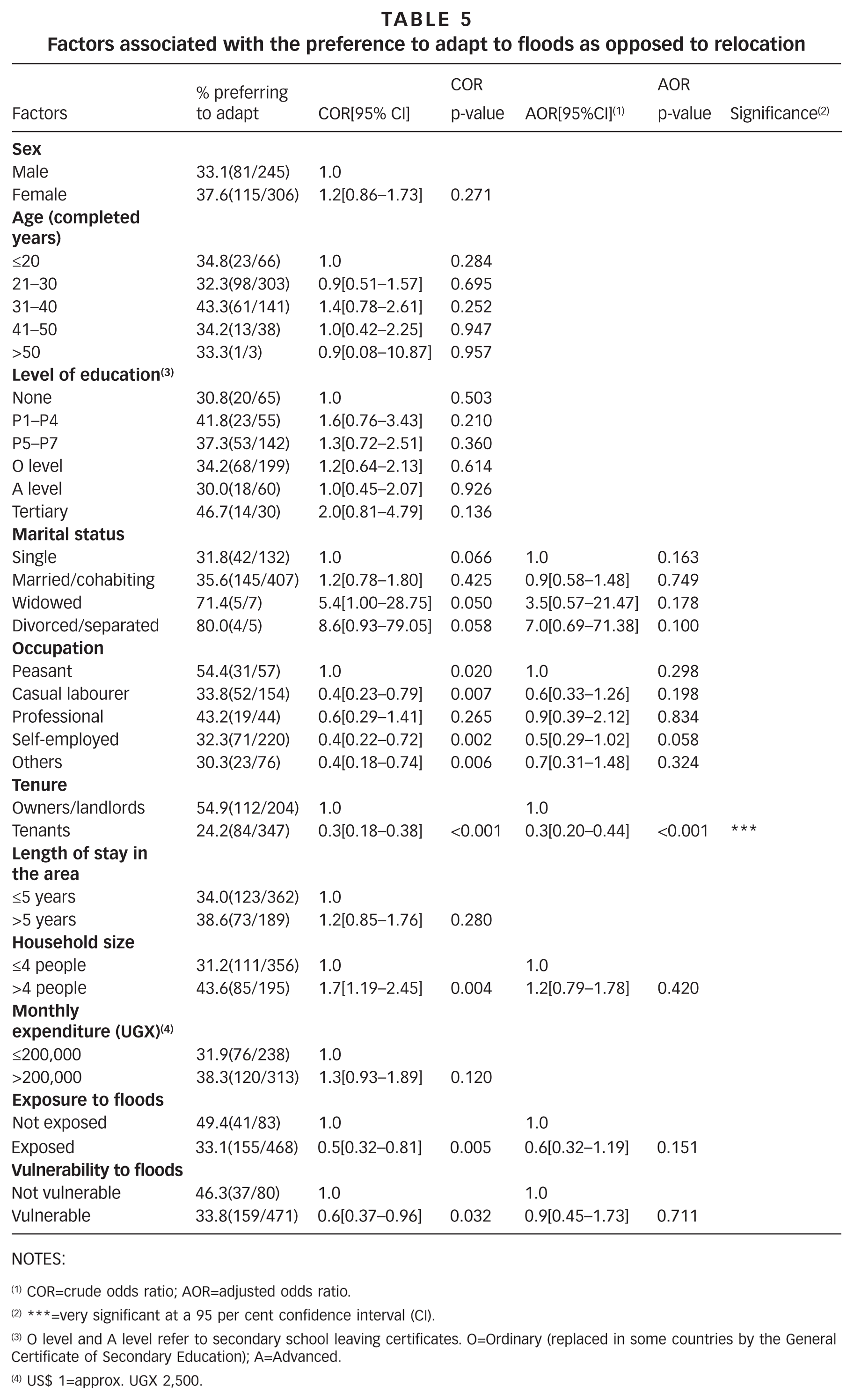
NOTES:
COR=crude odds ratio; AOR=adjusted odds ratio.
***=very significant at a 95 per cent confidence interval (CI).
O level and A level refer to secondary school leaving certificates. O=Ordinary (replaced in some countries by the General Certificate of Secondary Education); A=Advanced.
US$ 1=approx. UGX 2,500.
f. Perceived ability to afford adaptation
About 41 per cent (226/551) of respondents said they can afford to adapt while 59 per cent (325/551) said they cannot. The results of regressions presented in Table 6 show that age, level of education, occupation, tenure status, length of stay in the area, monthly expenditure and perceived vulnerability to floods are significantly associated with perceived ability to afford adaptation at the bivariate level of analysis. Multivariate analysis revealed that only level of education, occupation, tenure status and monthly expenditure were the factors significantly associated with perceived ability to afford adaptation (and not age, length of stay or perceived vulnerability). Respondents with an education level of at least primary one (P1) and above (except for A-level respondents, who could have been continuing students) were more likely to perceive themselves as able to afford adaptation. Also, peasants in this context were more likely to consider themselves able to afford adaptation than non-peasants. Tenants were less likely to perceive themselves as able to afford adaptation (AOR 0.3, 95 per cent CI 0.20–0.46, p<0.001) than house owners/landlords; and households that spent more than UGX 200,000 (US$ 80) per month were more likely to perceive themselves as able to afford adaptation (AOR 1.5, 95 per cent CI 1.00–2.28, p=0.05) than households that spent less.
Factors associated with the perceived ability to afford adaptation
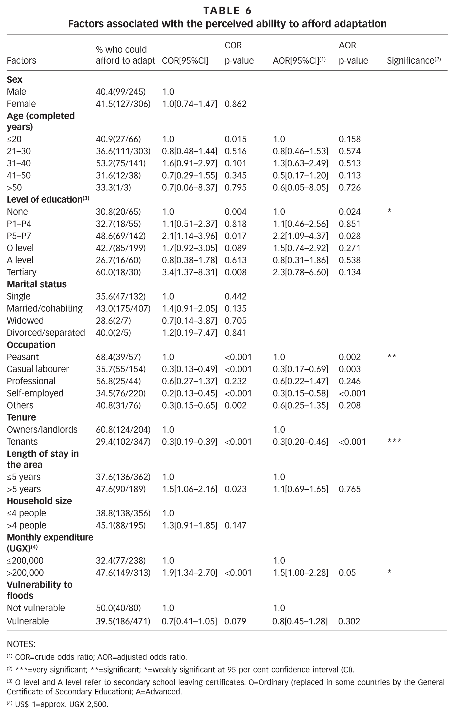
NOTES:
COR=crude odds ratio; AOR=adjusted odds ratio.
***=very significant; **=significant; *=weakly significant at 95 per cent confidence interval (CI).
O level and A level refer to secondary school leaving certificates. O=Ordinary (replaced in some countries by the General Certificate of Secondary Education); A=Advanced.
US$ 1=approx. UGX 2,500.
IV. Discussion
This section provides a synthesis and discussion of the findings regarding benefits associated with housing location and the wetland, adaptation mechanisms, preferences regarding adaptation and the perceived affordability of these. In addition, the government stance on the situation is discussed, as well as its implications for urban adaptation and resilience of vulnerable communities.
a. Benefits and opportunities enjoyed by wetland communities in Kampala
More than half of the households in this study mentioned free water as the main benefit from the wetlands. Earlier, a national inventory of benefits from wetlands in Uganda had also reported that water was the main benefit of 80 per cent of wetlands nationally.(21) Certainly, the high water table and the abundance of spring wells endow the wetland communities with free local sources of water. These water sources are, however, highly prone to pollution, especially in urban informal settlements.(22) The pollution sources, both point and diffuse, including wastewater,(23) industrial effluent,(24) and leachate from garbage(25) and pit latrines,(26) among other things, are associated with significant health risks.(27)
Another benefit mentioned by about half of the households is cheaper rent. In light of the rapid urban population growth, it is likely that more and more people will seek affordable accommodation against all odds. The growth of informal settlements in wetlands is driven by the cost of living in the city. Closer proximity to the CBD, roads, workplaces, places of worship, and social networks were also mentioned as benefits associated with location by a significant proportion of the households. These findings confirm earlier research indicating that proximity to previously built-up areas and public infrastructure are key predictors for urban expansion and encroachment on wetlands.(28)
As human activities continue to transform wetlands in pursuit of private benefits, societal benefits from wetlands and their ecosystem services gradually diminish. Water sources become polluted, and water quality and fish productivity are sacrificed for cheap land for cultivation, high crop yields, and sand and clay mining, among other benefits. Recently, Kampala’s local authorities seem to have accepted the practical difficulties of restoring natural wetland vegetation in the context of the myriad of competing wetland users and the grossly compromised capacity of these wetlands to treat wastewater.(29) Rather than aiming for restoration, they have now shifted focus towards construction of more wastewater treatment plants(30) and the use of the wetlands as urban parks for recreation.(31) However, this option may not be sustainable either, given the high construction and operational costs of conventional wastewater treatment plants. Rather, integrating engineered drainage and wastewater treatment systems with natural wetland ecosystems(32) might perhaps be a more sustainable option.
b. Adaptations to minimize vulnerability and exploit opportunities
To minimize their vulnerability to malaria-transmitting mosquitoes, most of the study households sleep under mosquito nets while others spray insecticides, close windows and doors early, and drain stagnant waters. Attention to drainage might be a less frequent response because, to be effective, neighbourhood drainage requires community cohesion and a sense of ownership, which are often lacking in such multi-ethnic and tenant-dominated urban poor communities. In Kampala, inner-city low-income communities were found to have lower community cohesion than those on the city-periphery.(33) Lack of community cohesion is often accompanied by weak social resilience,(34) which in turn increases the degree to which people will be impacted by a hazard. In this context, social resilience would refer to the ability of a community to mobilize its own resources quickly and effectively, and use them to anticipate, mitigate, adapt to, recover and learn from the effects of the hazards faced.
The adaptation mechanisms against floods and waterlogging identified in this study can be categorized under two levels: household and community. Household-level adaptations such as raising barriers around houses, building flood-resilient structures, adding soil to raise house foundations, digging trenches around the house, raising beds, and placing valuable items higher up above the floor, which were found to be common among flood-exposed households, have also been reported in several flood-prone urban informal settlements in Africa,(35) Asia(36) and Central America.(37) These household-level adaptations are, however, desperate and isolated efforts towards preparedness, response and recovery, with very limited impact in terms of risk reduction. Raising houses on stilts and purchasing flood insurance, reported in other studies,(38) were uncommon in our study community.
Community-level adaptations such as desilting drainage channels, raising embankments along streams or digging more drainage channels were undertaken by only a few members of the community, but were also said to be a source of conflict between farmers and residents. The conflict resulted from the diversion of floodwaters. It was established from the FGDs that when some community members diverted the waters away from the settlement to the wetland, this resulted in the flooding of crop fields. The farmers who had been affected reacted by diverting the waters back to the settlements. Some of the residents argued that the farmers were indifferent because they did not necessarily reside in flood-affected zones.(39) Some pragmatic communities do desilt local drainage channels when necessary, although this is properly the responsibility of the local authority and should be done with its consent. Drainage in the Nakivubo wetland is especially contentious, in part because of different objectives and a lack of coordination among stakeholders. For example, the redesign of storm drainage to spread/diffuse it upstream to protect the inner Murchison Bay from pollution(40) also increased flooding in the adjacent informal settlements. Effective adaptation cannot only be community-based but must be supported by the necessary infrastructure and institutional framework.(41)
Study results indicate that only about a third of households preferred to stay and adapt to floods and waterlogging rather than relocating; tenants, who are the majority, were still more likely to prefer relocation than house owners/landlords. There could be several explanations, for example the fear of confrontational enforcement against encroachment by government authorities, increased frequency and severity of flooding, and the limited capacity to adapt. Adaptation, whatever form it takes, requires investment.(42) Tenants in particular do not feel it is incumbent on them to take on this responsibility.
The challenge of adapting to minimize vulnerability in order to exploit opportunities in Kampala lies heavily with households. More than half of the households said they could not afford to adapt to the hazards faced in the area. It is important to note here that the perceived ability to afford adaptation was not necessarily understood in absolute monetary terms, but was very individual and affected by people’s circumstances and previous experience, including their level of education, occupation, tenure status and monthly expenditure. Peasants, for instance, were more likely to consider themselves able to afford adaptation than non-peasants. Since they are often considered a low-income occupation group, this finding is somewhat counterintuitive. However, the high demand for their produce places urban peasants in a better financial situation than their rural counterparts.(43) Also, the crops mostly grown, i.e. cocoyams and sugarcane, are less vulnerable to waterlogging than other property. Furthermore, the peasants’ frequent exposure to wet and muddy conditions on crop fields could leave them less fazed by these conditions, affecting their perception of the need for adaptation. Results also showed that tenants are less likely to be able to afford adaptation than house owners/landlords. Most tenants rent accommodation in these vulnerable locations because of financial constraints. Our results confirmed this: households that spent the equivalent of more than US$ 80 per month were more likely to invest in adaptation than households that spent less. The findings painted a clear picture of the link among urban poverty, vulnerability, and the limited ability to adapt.
The highly transient nature of low-income households in the study community challenges the building of social networks,(44) which are necessary in building community resilience. Frequent relocation of low-income tenant households is often the result of a failure to cope with local conditions, eviction or the inability to afford the cost of housing, as has been reported elsewhere.(45)
The gaps in community-level adaptation revealed in our findings are compounded by the threat of eviction. Key informants emphasized that the authorities are not ready to bend the law to accommodate wetland encroachers. There is not, in other words, an enabling environment to support adaptation.
V. Conclusions
This paper has presented and discussed findings on benefits that informal wetland communities in Kampala associate with the location of housing and the wetland itself, adaptation mechanisms to minimize vulnerability to hazards such as floods and disease vectors, preferences around undertaking adaptation, and the perceived ability to afford adaptation. We have shown the intricate nature of the interactions between social and natural components of the environment and the factors that shape the way in which risk is perceived or experienced. The willingness to adapt and perceptions of the ability to afford adaptation cannot be separated from the immediate benefit a community derives from its location. In this context, however, the process of adaptation often occurs at the expense of the natural environment. Our findings suggest a need for sustainable adaptation strategies and the involvement of all stakeholders, from the grassroots through the relevant government and partner institutions. Future research could therefore explore possibilities of coordinated adaptation strategies that enhance equitable utilization of wetland resources without compromising their ecosystem services and economic benefits.
Footnotes
Acknowledgements
The authors thank the Partners Enhancing Resilience to People Exposed to Risks (PeriPeri-U) project at the Makerere University School of Public Health and the African Doctoral Academy at Stellenbosch University for partially funding this study.
1.
Fuseini, I and J Kemp (2015), “A review of spatial planning in Ghana’s socio-economic development trajectory: A sustainable development perspective”, Land Use Policy Vol 47, pages 309–320; also Douglas I, K Alam, M Maghenda, Y Mcdonnell, and L Mclean (2008), “Unjust waters: climate change, flooding and the urban poor in Africa”, Environment and Urbanization Vol 20, No 1, pages 187–205; Hettiarachchi M, T H Morrison and C McAlpine (2015), “Forty-three years of Ramsar and urban wetlands”, Global Environmental Change Vol 32, pages 57–66; and Zebardast, E (2006), “Marginalization of the urban poor and the expansion of the spontaneous settlements on the Tehran metropolitan fringe”, Cities Vol 23, No 6, pages 439–454.
2.
Sapirstein, G (2006), “Social Resilience: The Forgotten Dimension of Disaster Risk Reduction”, Jàmbá: Journal of Disaster Risk Studies Vol 1, No 1, pages 54–63.
4.
Alberti, M (2005), “The Effects of Urban Patterns on Ecosystem Function”, International Regional Science Review Vol 28, No 2, pages 168–192, page 169.
5.
See reference 4.
6.
Turyahabwe, N, W Kakuru, M Tweheyo and D M Tumusiime (2013), “Contribution of wetland resources to household food security in Uganda”, Agriculture & Food Security Vol 2, No 1, Article 5.
7.
Kakuru, W, N Turyahabwe and J Mugisha (2013), “Total Economic Value of Wetlands Products and Services in Uganda”, The Scientific World Journal, 13 pages.
9.
This is in part to protect certain structures installed by government, e.g. for research or monitoring purposes, stormwater diversions, wetland boundary demarcations, etc.
10.
Okanya, A, and A Nantambi (2015), “Kampala, Wakiso, Mukono wetland atlas out”, New Vision, 26 August, accessed 27 August 2015 at ![]() .
.
11.
Wetlands Management Department-Ministry of Water and Environment, Uganda Bureau of Statistics, International Livestock Research Institute and World Resources Institute (2009), Mapping a Better Future: How Spatial Analysis Can Benefit Wetlands and Reduce Poverty in Uganda, World Resources Institute, Washington, DC and Kampala.
12.
Kansiime, F and M Nalubega (1999), Wastewater Treatment by a Natural Wetland: the Nakivubo Swamp, Uganda, A.A. Balkema Publishers, Rotterdam.
13.
Namakambo, N (2000), Kampala District Wetland Inventory Report, National Wetlands Programme, Wetlands Inspection Division, Ministry of Water, Lands and Environment, Kampala.
14.
Isunju, J B, K Schwartz, M Schouten, W P Johnson and M P van Dijk (2011), “Socio-economic aspects of improved sanitation in slums: A review”, Public Health Vol 125, No 6, pages 368–376.
15.
Huising, E J (2002), “Wetland monitoring in Uganda”, The International Archives of the Photogrammetry, Remote Sensing and Spatial Information Sciences, Vol XXXIV, Part 6/W6, pages 127–135.
16.
Nasinyama, G, D Cole and D Lee-Smith (2010), “Health Impact Assessment of Urban Agriculture in Kampala”, in G Prain, D Lee-Smith and N Karanja (editors), African Urban Harvest, Springer, New York, pages 167–190.
18.
Scott, D, C Oelefse and C Guy (2002), “Double trouble: environmental injustice in South Durban”, Agenda Vol 17, No 52, pages 50–57.
19.
Kiguli, J and L N Kiguli (2004), “Gender and Access to Land for urban agriculture in Kampala, Uganda”, UA-Magazine, pages 34–35.
20.
Other reported hazards, presented in a separate paper, included communicable diseases, vermin, dampness, poor excreta disposal, crime, pollution of water, air or soil, evictions, subsidence/collapsing of houses, and fires. See Isunju, J B, C G Orach and J Kemp (2016), “Hazards and vulnerabilities among informal wetland communities in Kampala, Uganda”, Environment and Urbanization Vol 28, No 1, pages 275–293.
21.
See reference 11.
22.
Isunju, J B, S Etajak, B Mwalwega, R Kimwaga, P Atekyereza, W Bazeyo and C J Ssempebwa (2013), “Financing of sanitation services in the slums of Kampala and Dar es Salaam”, Health Vol 5, No 4, pages 783–791.
23.
Fuhrimann, S, M S Winkler, P H H Schneeberger, C B Niwagaba, J Buwule, M Babu, K Medlicott, J Utzinger and G Cissé (2014), “Health risk assessment along the wastewater and faecal sludge management and reuse chain of Kampala, Uganda: a visualization”, Geospatial Health Vol 9, No 1, pages 251–255.
24.
Banadda, E N, F Kansiime, M Kigobe, M Kizza and I Nhapi (2009), “Landuse-based nonpoint source pollution: a threat to water quality in Murchison Bay, Uganda”, Water Policy Vol 11, No 1, pages 93–104.
25.
Nyenje, P M, J W Foppen, S Uhlenbrook and G Lutterodt (2014), “Using hydrochemical tracers to assess impacts of unsewered urban catchments on hydrochemistry and nutrients in groundwater”, Hydrological Processes Vol 28, No 24, pages 5860–5878.
26.
Lutterodt, G, J W A Foppen and S Uhlenbrook (2014), “Escherichia coli strains harvested from springs in Kampala, Uganda: cell characterization and transport in saturated porous media”, Hydrological Processes Vol 28, No 4, pages 1973–1988.
27.
Katukiza, A Y, M Ronteltap, P van der Steen, J W A Foppen and P N L Lens (2014), “Quantification of microbial risks to human health caused by waterborne viruses and bacteria in an urban slum”, Journal of Applied Microbiology Vol 116, No 2, pages 447–463.
28.
Vermeiren, K, A Van Rompaey, M Loopmans, E Serwajja and P Mukwaya (2012), “Urban growth of Kampala, Uganda: Pattern analysis and scenario development”, Landscape and Urban Planning Vol 106, No 2, pages 199–206.
29.
Mbabazi, J, J Kwetegyeka, M Ntale and J Wasswa (2010), “Ineffectiveness of Nakivubo wetland in filtering out heavy metals from untreated Kampala urban effluent prior to discharge into Lake Victoria, Uganda”, African Journal of Agricultural Research Vol 5, No 24, pages 3431–3439.
30.
Letema, S C (2012), Assessing sanitary mixtures in East African cities, Wageningen Academic Publishers.
32.
Lukooya Bateganya, N, J Tukahirwa, H Busulwa and T Hein (2013), “Integrating Wetland Ecosystem Services into the Planning of Urban Landscapes in Developing Cities of East Africa: Lessons From European Riverine Wetlands and Floodplains”, in C Griffith (editor), Paving the Way Forward in Urbanization and Global Environmental Change Research, Arizona State University, Tempe, pages 17–22.
33.
Chelleri, L, J J Waters, M Olazabal and G Minucci (2015), “Resilience trade-offs: addressing multiple scales and temporal aspects of urban resilience”, Environment and Urbanization Vol 27, No 1, pages 181–198; also Waters, J J J (2013), “The Role of Ecosystem Services and Adaptive Capacity in the Resilience of Poor Urban Areas”, Thesis submitted for the degree of Doctor of Philosophy to the School of Environmental Sciences of the University of East Anglia.
34.
See reference 2.
35.
Sakijege, T, J Lupala and S Sheuya (2012), “Flooding, flood risks and coping strategies in urban informal residential areas: The case of Keko Machungwa, Dar es Salaam, Tanzania”, Jàmbá: Journal of Disaster Risk Studies Vol 4, No 1, 10 pages; also Moser, C and A Stein (2010), Pro-Poor Adaptation to Climate Change in Urban Centers: Case Studies of Vulnerability and Resilience in Kenya and Nicaragua, World Bank, Washington, DC.
36.
Chatterjee, M (2010), “Slum dwellers response to flooding events in the megacities of India”, Mitigation and Adaptation Strategies for Global Change Vol 15, pages 337–353; also Satriagasa, M C, H Nugraha, W Riasasi, E Ayuningtyas and A U Rusdimi (2014), “Community-based Flood Adaptation in Vu Gia-Thu Bon Watershed, Central Vietnam”, Paper prepared for IJJSS 2014: The 6th Indonesia Japan Joint Scientific Symposium, Yogyakarta, 28–30 October.
38.
Odemerho, F O (2015), “Building climate change resilience through bottom-up adaptation to flood risk in Warri, Nigeria”, Environment and Urbanization Vol 27, No 1, pages 139–160.
40.
41.
Lwasa, S (2010), “Adapting urban areas in Africa to climate change: the case of Kampala”, Current Opinion in Environmental Sustainability Vol 2, No 3, pages 166–171.
42.
See reference 41.
43.
See reference 7.
44.
O’Keefe, M, C Luthi, I K Tumwebaze and R Tobias (2015), “Opportunities and limits to market-driven sanitation services: evidence from urban informal settlements in East Africa”, Environment and Urbanization Vol 27, No 2, pages 421–440.
45.
Bartlett, S (1997), “The significance of relocation for chronically poor families in the USA”, Environment and Urbanization Vol 9, No 1, pages 121–132.