
Abstract
Poor communities living in areas at high risk of flooding are often considered by authorities to be victims of their own “choice” in locating their dwellings in such areas. Instead of the government contributing to improving their resilience, the situation can become a way to justify the people’s relocation to areas not susceptible to flooding. The dynamics of living in flood-prone areas are examined here in the context of the Baixada da Habitasa and Seis de Agosto districts in Rio Branco, Acre, Brazil. Analysis of documents and semi-structured interviews with managers and with inhabitants of the districts under study, obtained soon after the last flood (April/May 2014), provide the basis of this study. Situations where people face up to the floods and reject removal to temporary shelters (or the temporary payment of a monthly sum as rent) are explored. This resistance to relocation can be seen even when the state proposes their transfer to permanent housing.
I. Introduction
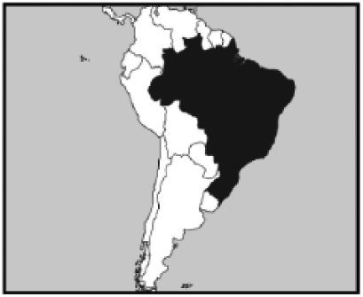
Acre is a state of Brazil, situated at the extreme southeast of the Brazilian Amazon. Its soils, derived from sedimentary rocks, support a highly preserved natural vegetation consisting mainly of tropical forest. The climate is equatorial, characterized by high temperatures, high annual rainfalls of around 2,000 millimetres and high relative humidity. Its hydrography, formed by the Juruá and Purus river basins, provides good drainage across all the municipalities in the state. The capital, Rio Branco, has a population of 336,038 inhabitants (according to the 2010 census by the Instituto Brasileiro de Geografia e Estatística (IBGE) – Brazilian Institute of Geography and Statistics). Rio Branco is crossed by the River Acre, which is fed by several tributaries.(1)
These natural conditions are responsible for floods that occur and persist for an average of 30 days per year in several districts of Rio Branco, including part of the city centre (Photo 1), mainly as a result of the slow rise of the water level of the River Acre, and the slow return of its waters to the main channel. This natural phenomenon is associated with socio-environmental factors that have varying impacts on the populations resident in the flooded districts.(2)
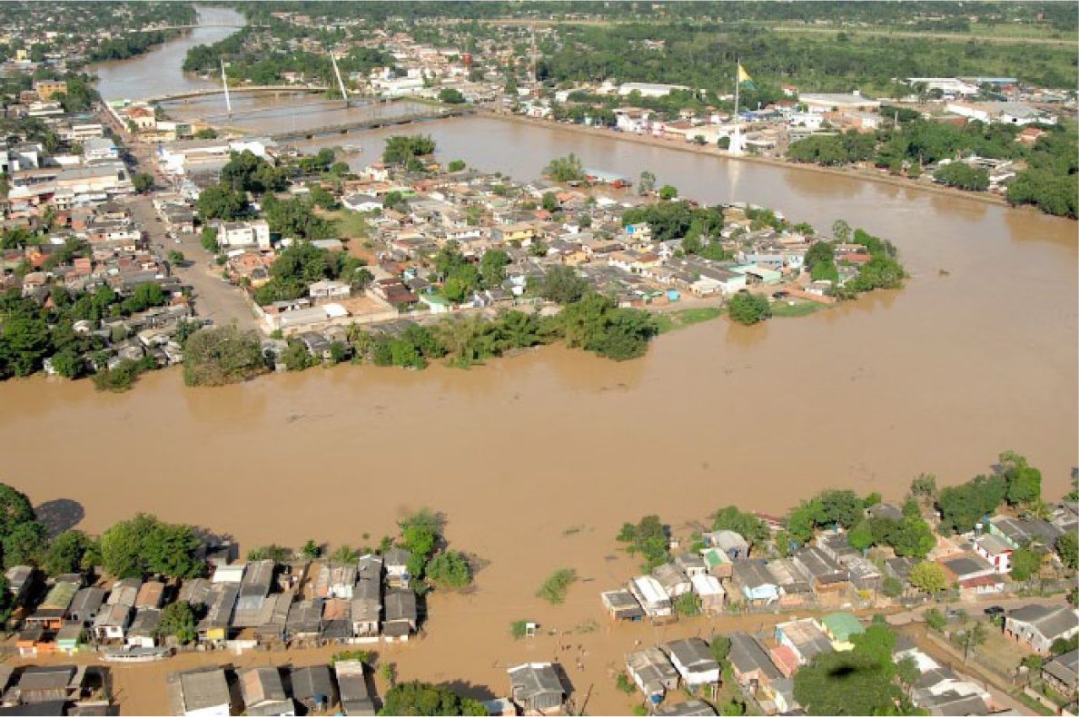
Central area of Rio Branco during the flood of 2012
Some districts are affected every year between the months of January and April. Others are only affected by exceptional flooding, such as that in: 1988 (with a maximum level or ML of 17.12 metres), 1997 (ML=17.66 metres), 2006 (ML=16.72 metres), 2009 (ML=15.50 metres), 2010 (ML=15.53 metres), 2011 (ML=16.16 metres) and 2012 (ML=17.64 metres). Among these floods, special mention should be made of the most recent in 2012 – the second largest recorded, after 1997 – not only because of the volume of water, but also because of the social, economic and environmental damage caused.(3) Figure 1 indicates the areas that would be inundated in the city centre with a water level of 18.00 metres, only slightly higher than the 2012 flood.
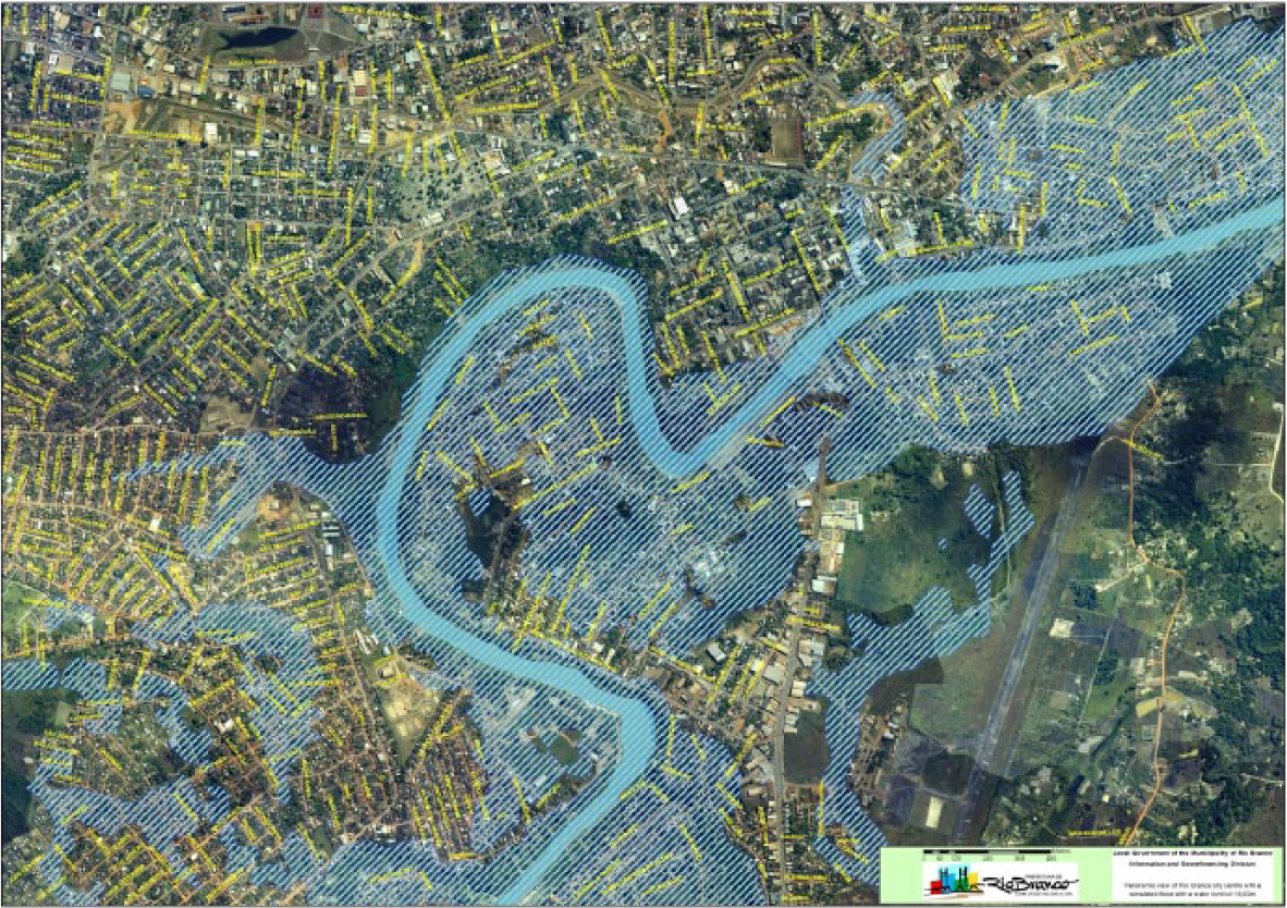
Panoramic view of Rio Branco city centre with a simulated flood with a water level of 18.00 metres
The extent and impact of the 2012 flood are demonstrated by its spread on reaching a level of 17.64 metres, i.e. 3.64 metres above the overflow level, through 30 districts of the city, with 30,173 buildings destroyed or damaged.(4) Only 1,783 families (6,803 people in total) were admitted to the six temporary shelters, while most others made homeless sheltered with relations. An estimated 32,076 people in all were affected across the 30 flooded districts; in 14 of these districts, floods covered more than 30 per cent of the total area. Especially hard hit were the Baixada da Habitasa district, with 87.6 per cent affected, involving 503 properties, and Seis de Agosto, with 43.0 per cent affected and 1,211 properties inundated (Figure 2A and Figure 2B).(5) The total value of the losses and damage so caused to the environment, natural resources, economy and society was US$ 94 million.(6)
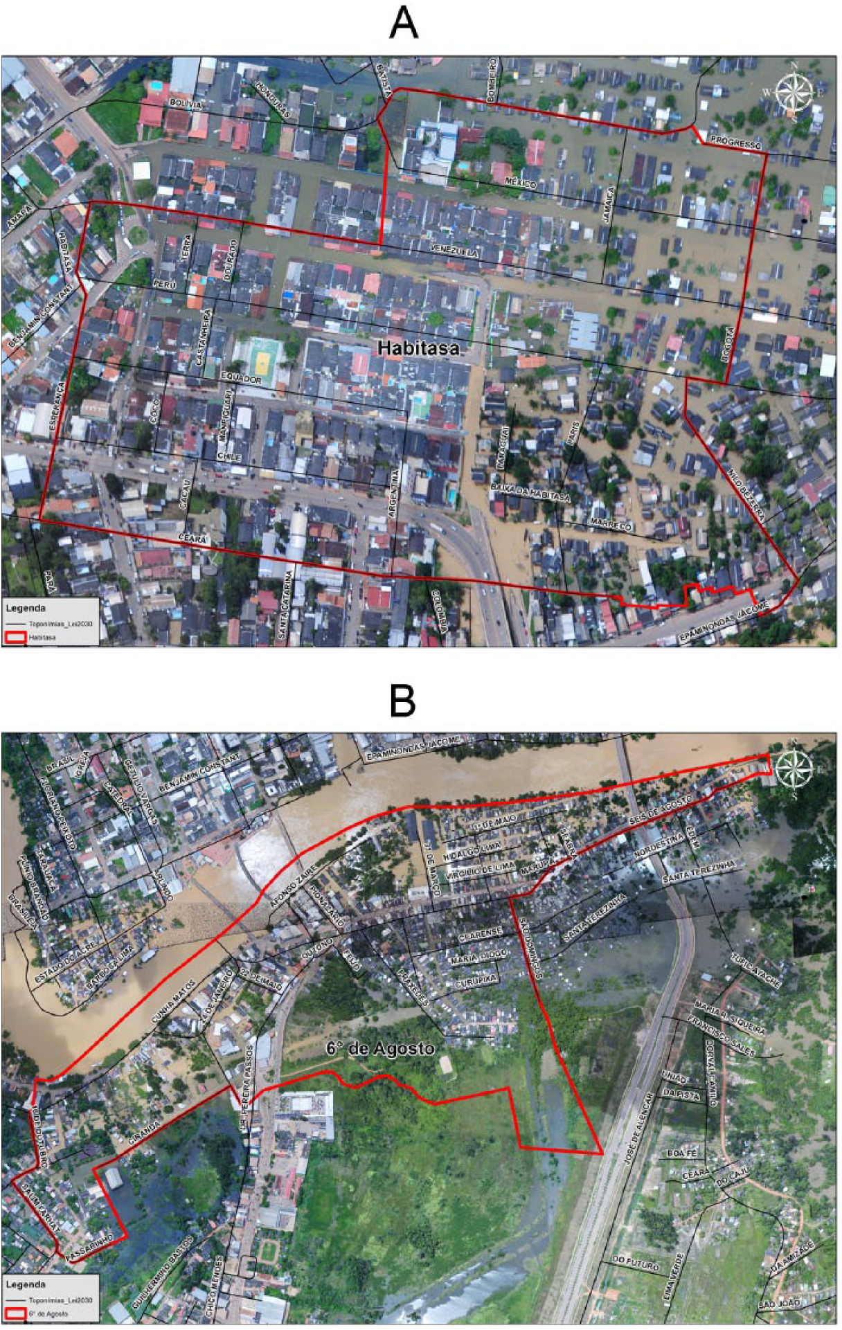
The Baixada da Habitasa and Seis de Agosto districts during the flood of 2012
Up to the 1970s, Rio Branco followed its normal course of political, economic and socio-cultural development, with public authorities just managing to keep up with the rate of population growth, both natural and migratory. Migration to the city from forest communities, displaced by the arrival of cattle graziers from the centre-south of Brazil during the 1970s,(7) caused the rapid growth of several new districts in the city. At least 30 of these districts were in areas susceptible to the periodic flooding of the River Acre, especially the districts of Taquari, Triângulo Novo, Cidade Nova, Baixada da Habitasa and Seis de Agosto.
State and municipal public authorities adopt both short- and long-term measures in response to serious floods. During flood periods, many people may relocate to temporary shelters, and emergency supplies of drinking water and food, and immunization against contagious diseases, are provided. After the waters have returned to the river’s main course, part of this population, those who are at special risk, are evacuated to safe areas. At the same time, reconstruction of the district infrastructure is carried out.
Some idea of the difficulties encountered in dealing with these flood-prone areas can be gained by observing that, even in the more well-to-do areas of the city, there are problems with sanitation and drainage, and this where the population is better equipped to cope with these problems. In the poorer areas, the lower levels of schooling and income can exacerbate the difficulties.(8)
For decades, the authorities have put off developing efficient and effective responses. To this should be added the fact that the planning decisions for these districts are for the most part “from the top down”, without the participation of the people who live in these areas – the parties mainly concerned with the issue.(9)
However, the present mandates of the state and municipal governments include a greater focus on the problem, and there is a disposition to resolve it definitively. This is mainly through the removal of those residing in the flood-prone areas to housing blocks. Some of these are social housing and others, like the Cidade do Povo, meet a higher standard and include infrastructure. The Cidade do Povo has an outpatient clinic, school and shops, with a total of 10,518 units – around 60,000 people. A third of these units is intended as social housing, at zero cost, for the low-income population living in risk areas, especially those subject to flooding.(10)
Although these housing blocks are located in flood-free areas, this does not mean that they represent the heart’s desire of all those who are supposed to be relocated to them. There is conflict and discontent on both sides – the managers and the future dwellers.
The fact is that only part of the problem is resolved through relocation. There are significant factors that provoke resistance to removal. To live in the districts subject to flooding means living closer to the central area of the city, near jobs, schools and urban amenities. But it also means a continued lack of any sort of urban service such as drainage, solid waste disposal, sewerage and drinking water.
This paper takes a two-pronged approach: it looks on the one hand at the demands of the flood-prone areas and the interventions needed on the part of the authorities to resolve their problems, and on the other at the attitudes of the residents – how they cope with the setbacks they face, sometimes rejecting the initiatives of the authorities to remove them.
The paper draws from two main data sources: government documents and the responses of both state and municipal managers and the inhabitants of the districts of Baixada da Habitasa and Seis de Agosto. Semi-structured interviews were carried out with 12 residents (six from each district), between April and May 2014, as well as with representative officials in the field of urban infrastructure, specifically around the management of flood-prone areas.
To protect the identity of the residents interviewed, each was provided with a fictitious name, which was added to the alpha-numeric code from the front wall of their residence. These codes were used by the public authorities to identify the inhabitants of the risk areas; the letters identified the districts (BH indicates Baixada da Habitasa and SA Seis de Agosto), and the numbers indicated the order in which households were registered (01, 02, 03…). As for the officials, it was felt that there was no need to maintain their anonymity, if only because of the public positions that they occupied.
This paper also draws on the experiences of a nonparticipating observer of the work of the Municipal Civil Defence as it provided relief to the victims of the flood that occurred between January and February 2014.
II. The Waters are Coming and the People are Preparing
In a historical analysis of public policy for the resolution of problems relating to the urban sanitation situation in the districts of Rio Branco affected by the flooding caused by the River Acre, three distinct phases can be discerned.(11)
Between the emergence of the city in 1882, and the 1970s, almost nothing was done.
From the 1970s to the 1990s, with the increase in the number of residents living in this situation, the authorities felt obliged to help those affected, removing them to temporary shelters, but without adopting a clear policy that went beyond palliative solutions.
From the 1990s to the present day, there has been a willingness on the part of the authorities to face up to the problem more explicitly, with actions ranging from the possibility of infrastructure improvements to the removal of residents from more critical areas into permanent dwellings.
The focus of the present article is only the third phase.
The migrants who arrived in Rio Branco in the 1970s were almost exclusively rubber workers expelled by the arrival of large agricultural and extractivist projects in the rural areas of Acre. They started to occupy uninhabited spaces with no owners present, on the periphery or preferably near the centre of the capital, and a large part of these areas was subject to flooding. As they settled in, facing up to the local powers, contesting ownership of the spaces that they had occupied, and putting down roots, their territories started to be distinguished by specific ways of life that included, in addition to dealing with the seasonal flooding, coping with the precariousness of inadequate infrastructure.
These settlements and the lifestyle that went with them were resisted by the public authorities, as they did not fit into the rules of urban planning: in the place of streets, there were alleys; drinking water and electric power were, in large part, “stolen” by means of clandestine connections; domestic waste was jettisoned on wasteland; sewage flowed in the street; the plots of land were not properly delimited and fenced off; and the houses were not built to typical urban building standards.
The districts of Baixada da Habitasa and Seis de Agosto, in addition to having these features, were also frequently flooded. In contrast to the other periodically flooded districts, where flooding occurs on average once every five years when there are major floods, in these two districts it occurs every year, as soon as the waters of the River Acre reach their overflow level.(12) People residing there have a whole system of responses to the floods, from forecasting their onset to determining the possibility of returning to their dwellings.
It is precisely by appropriating this responsibility for the flood risk to which the residents are subject that the present public entities justify their efforts to remove the populations who live there to areas that are free from the threat of flooding, and constructed in conformity with more acceptable principles of residential urban planning. However, they have also been providing some infrastructural services to the two districts, such as paving and drinking water, with a view to meeting some of the needs of the residents who resist removal.
Analysing the question in more detail, it can be said, therefore, that there are two fronts of intervention in these flooded areas: removal (either to temporary shelters or to permanent dwelling places) and improvement of the local infrastructure.
a. Removal: from resistance to acceptance
It is important to stress that removal is the primary policy for resolving the problems of the districts in question – on the part of both the government of the state of Acre and the local government of Rio Branco – and this is reflected in the observations of the officials interviewed, as can be seen from the following extract:
“Really for these areas subject to flooding, that we normally characterize as risk areas and areas which are too unhealthy even to be occupied, [the goal] is to remove people from them. Because when these areas are occupied, you saturate them – if you don’t have adequate sanitation you end up saturating these areas, and by the technical recommendations of the CPRM(13) – who today are our consultants for these risk and flooded areas, because even when they are not flooded these are risk areas – the technical recommendation is always the removal of this population.”(14)
The fact is that the present officials, having inherited a problem that goes right back to the beginnings of the town of Rio Branco, with no real response from past administrations, have decided to eliminate it in as straightforward and radical a manner as possible. They are going beyond their role as urban regulators and providers of infrastructure, and are removing residents to new territory,(15) built, in large part, to be completely different from the communities that they built themselves.(16) In some cases, in an even less satisfactory solution, residents are moved to temporary quarters.
b. Temporary shelters and social rent
In the face of an insufficient supply of social housing to meet these demands, there are three types of temporary shelter, related to the floods in Rio Branco:
buildings specifically constructed for people rendered homeless by the flood, and later dismantled when they are able return to their districts;
the residences of relatives; and
more permanent properties, rented with a subsidy from the public authorities, to shelter those who have lost their property during the flood or are at risk.
Residents may select these rented dwellings, and apply the monthly payment from the authorities to the rent. This varies between US$ 133 and 223,(17) depending on the number of household members.(18) The insignificant amount of this “social rent” is a matter of dispute on the part of the residents because it may not cover the rent of a dwelling large enough for whole family, or the other associated expenses such as rates (property tax), electricity and transport. This makes it an unattractive option for many.
According to one affected resident:
“Leave my little shack to go and pay rent? Another thing, at the time, the money they were giving for rent was 300 reals. For 300 reals you couldn’t accommodate a family. So if we got a house we could put a family in we would have to make up the rent money out of our own pockets: Over my dead body I say.”(19)
Another concern is the delay that can occur in paying the benefit, causing misunderstanding between the tenants and the property owners. There is also the uncertainty around the ultimate provision of permanent social housing, which makes it unclear how long residents will need to remain in the rental properties. As Vargas points out: “to leave the condition of risk through removal, even with public subsidies for the payment of rent, does not provide the desired level of security. The expectation of receiving their own house, which frees them from the threat of expulsion, continues.”(20)
c. Permanent social housing
A preliminary analysis of the policy of removal to permanent dwellings indicates that for residents in precarious conditions, the only truly acceptable solution is transfer to a planned housing block built in accordance with all the conventional urban standards. Otherwise, interviews indicated that residents’ decision to accept removal or not depends on factors external to the removal policy, and related mainly to their cultural and socio-economic conditions.
For those who came from the rubber plantations of the rural zone in Acre and who have lived for decades in areas subject to flooding, the familiarity with proximity to water courses, whether for leisure purposes or the satisfaction of their material needs, is a determining factor. One person interviewed in Baixada da Habitasa declares: “[…] my father fishes, he works in the fishery business, we are going to put the motor where? The nets where? On our heads? Where are we going to fish? There’s going to be nowhere for us to fish there, don’t you think?”(21)
As regards socio-economic conditions, it was evident that the main justifications for resistance to removal – especially for those who were to be transferred to the Cidade do Povo project – were the size of the new properties, their location and distance from the city centre, and the impact of the built form (terraced housing) on their social relationships.
In the flood districts, homes tend to be built, even if with much difficulty, large enough to accommodate the number of household members. In the new properties, there is a legally defined spatial homogeneity related to the standards for social housing (also known as “housing of social interest”):(22)
“Everything is foreseen in the works code, in the conventional questions of architecture… Really, everything. There is nothing out of the normal, now it is a social housing unit, a social model, it is a dwelling of social interest; and a dwelling of social interest is also characterized, it has a certain area to be considered of social interest; we are working with a state government programme, with the federal government, with federal standards, federal legislation and resources that have limitations for dwellings of social interest; so that there are income brackets that delimit this dwelling of social interest.”(23)
Instead of building standards reflecting the social realities of the potential inhabitants, the inhabitants are expected to adjust to the new established standard. This adjustment is a challenge: “the space they are providing for a family is insufficient, there is no space; the houses are really small; another thing, they cannot be expanded, there is no way to add to them; my family can’t fit into the space they are going to provide […]”.(24)
As regards the location, its acceptability is intimately related to the time it takes residents to get to the centre of Rio Branco, where they earn their living. Their current homes in Baixada da Habitasa and Seis de Agosto are just a few minutes from the city centre, a distance that can easily be covered on foot. From the Cidade do Povo, by contrast, the distance is at least 10 kilometres. This forces this low-income population to use public transport, which in its turn has an impact on the family budget.
So we have reactions like the following: “for us, who work here… a long way off! The city centre to my work, a minute and I’m there; and out there [referring to the Cidade do Povo] it takes half a day to come and go.”(25)
As regards the reluctance of the people living in the areas subject to flooding to go to the terraced Cidade do Povo houses, the words of Silva SA-39 represent a typical argument:
“Now pay attention! My son, like the government, he only thinks of himself. He doesn’t think of our part: it’s a house only for two families. And if in that house for two families he puts there some people who aren’t all that good; he puts there a drug trafficker, he puts a noiado [addict]. Look here son, I think that that is a lack of respect of the government for the people. They want to stick us besides some people who we don’t know […]. Who really likes this business of emendado [terraced housing]? If I wanted to live like that I wouldn’t be here, I would be living in a big house, divided into rooms for rent. Terraced housing, a great pile, not even a bug can stand it, I’m not going there.”(26)
When this woman insists that she will not go to the Cidade do Povo to live in a house that will be occupied by two families, her tone suggests at first that this rejection is due only to the fear that her future neighbours may possibly not be very good people and may cause her harm. Given that it is far more likely in the Cidade do Povo that a person of goodwill will be the neighbour rather than a drug trafficker or an addict, it becomes evident that the real concern is something different. It is not only the fact of living “in terraced housing, piled up like bugs” with unknown people who are not good people and who could do her harm. It is the unfamiliarity of the entire pattern of the built environment. The boundaries that separate neighbours in Baixada da Habitasa and Seis de Agosto are fences defining the lots, not walls dividing houses into two, as in the Cidade do Povo. Instead of freestanding houses separated by narrow alleyways, the Cidade do Povo has large blocks of terraced housing, divided by wide streets. Back in Seis de Agosto there is first the individual house and the land that it is on, occupied possibly only by this woman and her husband; second, the neighbourhood as a social territorial construct, with its possibilities for both present and future relationships of both trust and distrust, with friends and enemies; and last, the relationship she has with the district, its periphery and so many other places of political, economic and social intercourse (network territories).(27)
The “fear” of the person interviewed, therefore – that we may suppose to be common to a large number of the people living in the areas subject to flooding – is that of facing up to the new. They have to go through a process of deterritorialization of the safe familiar place they are part of, built up socially over time, and of the reterritorialization imposed by the public authorities.
Removal, it has to be admitted, is an extreme solution that should be supported by very convincing justifications. Two such justifications have been presented by the authorities: 1) the floods, because of their natural (or divine) character, have proved themselves difficult or even impossible to prevent; and 2) the risks of disasters caused by flooding are high.
As regards the first, realistically, the economic conditions of the state and the local city government are insufficient to cope with the scale and cost of the kind of engineering work that might offer protection. From a cost–benefit perspective (economic and social benefits) it seems to be more realistic to remove the people from the areas subject to flooding than to attempt the management task that would be necessary every year.
And as regards the risk of disaster, due to its complexity, this needs to be discussed more closely. This is done in the following section.
III. The Vulnerability to Risk or the Risk of Vulnerability
What are the risks of disaster and what level of threat are we talking about? And further, what is the degree of vulnerability of the inhabitants of these flood-prone areas?(28)
There seems to be no doubt from this perspective about the urgent need for this policy of removal. As if the high probability of the floods occurring every year were not enough, the damage or loss (human, material and environmental) caused by them, even if only temporary, is considerable.
However, when one considers the classic concept of risk (as a function of threat and vulnerability) another interpretation of the “need” for removal presents itself in concrete fashion.
When we consider the frequency of flooding (every year) in the more critical areas of Rio Branco and the inability of the public authorities to contain these floods, we can conclude that these territories are indeed vulnerable to this natural phenomenon, obeying a seasonal logic. From a historical perspective, however, it has to be acknowledged that even if these territories are vulnerable to the current flooding, in the sense that it cannot be prevented, the same cannot be said of the populations inhabiting these districts, given their resilience in facing up to the risks arising from this flooding, and their capacity to respond.(29)
An important fact to consider is that, after 40 years of occupation of these flood-prone lands, their occupiers are clearly determined to remain there, despite the fact that the authorities consider these areas to be sub-standard, uninhabitable and not worth the development of concrete solutions for protecting the houses and lands. This determination, possibly, amounts to a disqualification of their right to live in and be part of the space of a “conventional city”.(30)
This does not mean that the exposure of these inhabitants to the floodwaters (whether before, during or after their occurrence) is not recognizable as a potential risk, especially to health. This is attested to by the very fact that the authorities see the main solution to the problem to be the removal of part of the population, rather than the promotion of infrastructure at least minimally capable of mitigating the effects of flooding.(31) The sewerage system of Rio Branco is intended to completely separate rainwater from sewage, treating them in different systems; in these districts, however, it is a single system, exposing the inhabitants to water-related diseases. The possibility of catching these diseases is a burden added to the material losses from the floods, which may extend from the loss of a few objects to the total loss of the dwelling. The losses, furthermore, are related not only to submersion in the course of the flooding, but also to human actions provoked by the flood, such as robbery and theft (practised by the so-called “water rats”) and the unintended loss or destruction of domestic property by the authorities in the course of removing the inhabitants to provisional shelters.
However, because the floods in Rio Branco normally occur predictably between the months of February and March, the consequent “disaster” is relatively easy to forecast and thus the material and human damage is to some degree capable of being controlled.
The evidence for this is the well-established processes in place for dealing with the problem. Inhabitants start to watch the news more attentively by the end of January – one of the rainiest months – and monitor the behaviour of the waters in the River Acre, principally the levels of alert and the amount of overflow. They know with certainty that as soon as the river leaves its main channel, their backyards will start to receive the first water. This is the time then to caulk the canoe (if they have one), to make the shelters(32) for their animals (dogs, chickens, ducks, pigs, cats, etc.), and to prepare the platform for storing things that cannot get wet (refrigerator, television, sound system and washing machine, among other things). As the water level rises, the platform gets moved up with it, as far as it can be raised. As for smaller articles, they are boxed up and ready for transport, if it should be necessary to leave the house.
When to leave? Under what conditions to leave? These are some of the questions that, full of material and symbolic meaning, make the decision to leave speculative and difficult. This being the case, the decision is only made, at least by a significant number of the inhabitants, when the situation becomes really extreme.
The authorities, instead of helping to improve the resilience of these communities, so as to reduce their vulnerability to the natural risks of flooding, end up assuming and encouraging responses to a vulnerability that is greater than what they actually perceive and experience, in this way superimposing technical and scientific rationality onto social rationality.(33)
IV. Conclusions
The empirical studies undertaken in the districts of Baixada da Habitasa and Seis de Agosto in Rio Branco, Acre reveal that the public policies proposed for these flood-prone territories are a response more to a top-down view, on the part of the public authorities, than to the interests of a significant number of the inhabitants of the flood-prone lands, even if not the majority. They are solutions that fail to take into account the kinds of socio-ecological tendencies that are highlighted by the most modern concepts of resilience.(34)
From the viewpoint of the authorities, the prevailing hypothesis is that these districts are uninhabitable because of the potential disasters related to periodic flooding, about which nothing can be done. In this context, the only reasonable risk management measures are seen as the removal of at least those inhabitants of the more critical areas, initially to temporary shelters and subsequently to permanent housing blocks.
It is important to stress that there is no unanimity among the inhabitants of Baixada da Habitasa and Seis de Agosto; some accept this argument and others reject it. Those who accept it can more easily be convinced of the need for removal, even if it is not a spontaneous conviction on their part.
On the other hand, those who reject it justify their resistance to removal on the basis that living conditions in the flood-prone lands themselves are better than those in the housing alternatives that are offered.
Taken to the extreme, the government measures will have a series of objective and subjective implications both for those removed and for those who stay. This is because, along with the removal of the inhabitants (deterritorializing them), the objective is to physically destroy the territories occupied by them, removing all the buildings. Those who depart to new housing will need to adjust themselves to new rules, customs and ways of living, different from those that they have been accustomed to. No less problematic will be the situation of those who resist and stay in the destroyed territories, as they will also have to reterritorialize, with new references for their lives and dreams.
Footnotes
Acknowledgements
The authors thank two anonymous reviewers for constructive feedback on an earlier version of the manuscript and the editors of Environment and Urbanization for reviewing the final version of the paper. We also thank the people and public servants of Rio Branco, Acre, who kindly agreed on providing interviews for the research.
Funding
We also acknowledge the Brazilian Coordination for the Improvement of Higher Education Personnel (CAPES) for the support to the development of the PhD programme of the first author.
1.
Acre (State) (2010), Natural resources: geology, geomorphology and soils of Acre, ZEE/Acre, Phase II, State Secretariat of the Environment – SEMA, Acre State Ecological-Economic Zoning Programme, Rio Branco, 100 pages; also IBGE (2014), Estados [States], available at http://www.ibge.gov.br/estadosat/perfil.php?sigla=ac; and Macêdo, M N C, H C T Dias, F Maria, G Coelho, E A Araújo, M L H Souza and E Silva (2013), “Rainfall and flow of the Riozinho do Rôla Basin on Western Amazon”, Ambiente & Água Vol 8, No 1, pages 206–221.
2.
On the risks related to flooding see Nchito, W S (2007), “Flood risk in unplanned settlements in Lusaka”, Environment and Urbanization Vol 19, No 2, pages 539–551; and Plate, E J (2002), “Flood risk and flood management”, Journal of Hydrology Vol 217, Nos 1–2, pages 2–11.
3.
4.
Brazil (2013), Banco de dados e registros de desastres: sistema integrado de informações sobre desastres - S2ID [Database and disaster records: integrated disaster information system - S2ID], Brazil Ministry of National Integration, National Civil Defence Secretariat, available at ![]() .
.
5.
6.
Local Government of the Municipality of Rio Branco (2012b), Relatório de avaliação de danos (AVADAN) [Damage Assessment Report], Rio Branco. Values in reals were converted into US dollars using information provided by the Brazilian Central Bank, available at ![]() .
.
7.
Oliveira, Luiz Antonio Pinto (1985), O sertanejo, o brabo e o posseiro: Os cem anos de andanças da população acreana [The backwoodsman, the hired ruffian and the land grabber – The one hundred years of the wanderings of the people of Acre], Dissertation, Federal University of Minas Gerais, Belo Horizonte, 101 pages.
8.
Regarding the levels of schooling and of income, together with other variables, influencing the coverage of the water supply and sewerage network, consult Rezende, S, S Wajnman, J A M Carvalho and L Heller (2007), “Integrando ofertas e demandas de serviços de saneamento: Análise hierárquica do panorama urbano brasileiro no ano de 2000” [“Integrating supply and demand of sanitation services: hierarchical analysis of the Brazilian urban panorama in the year 2000”], Engenharia Sanitária e Ambiental Vol 12, No 1, pages 90–101. In relation to urban inequalities in general, see Stephens, C (2011), “Revisiting urban health and social inequalities: the devil is in the detail and the solution is in all of us”, Environment and Urbanization Vol 23, No 1, pages 29–40. And for specifics see Nornan, G and S Pedley (2011), “Exploring the negative space: evaluating reasons for the failure of pro-poor targeting in urban sanitation projects”, Journal of Water, Sanitation and Hygiene for Development Vol 1, No 2, pages 86–101.
9.
See Gohn, M da G (2004), “Empoderamento e participação das comunidades em políticas sociais” [“The empowering and participation of communities in social policies”], Saúde e Sociedade Vol 13, No 2, pages 20–31.
10.
11.
On the structural evolution of Rio Branco, consult, among other references: Acre (Territory) (2002), Relatório de governo (1899 to 1905), Os anos do conflito [Government report (1899 to 1905), The years of conflict], José Plácido de Castro, Gabino Besouro, Deocleciano Souza, Epaminondas Jácome (Printing House of the Law Court of the State of Acre), Rio Branco; Acre (Territory) (1930), Relatório de governo elaborado por Hugo Ribeiro Carneiro 1928/1929 e enviado ao ministro da Justiça e Negócios interiores [Government report prepared by Hugo Riberio Carneiro 1920/1929 and sent to the Minister of Justice and the Interior], Augusto Vianna de Castello, Rio Branco; Acre (Territory) (1947), Relatório apresentado ao Exmo. Sr. General Eurico Gaspar Dutra, D. S. Presidente da República pelo Major José Guiomar dos Santos, Governador Delegado da União no Território Federal do Acre referente às atividades da administração acreana no exercício de 1947 [Report presented to General Eurico Gaspar Dutra, President of the Republic by Major José Guiomar dos Santos, Governor Delegate of the Union in the Federal Territory of Acre relating to the activities of the Acre administration in the year 1947], Rio Branco; and Local Government of the Municipality of Rio Branco (2014b), Prefeitura de Rio Branco com você no dia a dia [Local Government of the Municipality of Rio Branco with you in your daily affairs], available at ![]() .
.
12.
See reference 3.
13.
The Mineral Resources Survey Company (CPRM) is a company of the Brazilian government, connected to the Ministry of Mines and Energy, that is responsible for geological services in Brazil.
14.
Santos, M J S (2014), Interview with the research project “A dinâmica das águas e das gentes: histórias, percepções e políticas públicas de saneamento em áreas inundáveis de Rio Branco” [“The dynamics of the waters and the peoples: stories, perceptions and public policies of sanitation in areas subject to flooding in Rio Branco”], July, Federal University of Minas Gerais/Federal University of Acre (UFMG/UFAC), Rio Branco.
15.
A good discussion of territories can be found in Haesbaert, R (2004), O mito da desterritorialização: do fim dos territórios a multiterritorialidade [The myth of deterritorialization: from the end of the territories to multiterritoriality], Bertrand Brasil, Rio de Janeiro.
16.
In the territory constructed by the public authorities there is inflexibility regarding some practices that can be seen in the flood-prone areas, such as the raising of animals and the increase of the size of the residence in accordance with the needs of the inhabitants.
17.
Values quoted on 06/09/2014, in accordance with information collected from Banco Central (Brasil), Dólar americano, available at ![]() . (US$ 1 = 2.24 real.)
. (US$ 1 = 2.24 real.)
18.
Silva, C D (2014), Interview with the research project “A dinâmica das águas e das gentes: histórias, percepções e políticas públicas de saneamento em áreas inundáveis de Rio Branco” [“The dynamics of the waters and the peoples: stories, perceptions and public policies of sanitation in areas subject to flooding in Rio Branco”], April, UFMG/UFAC, Rio Branco.
19.
![]() , Interview with the research project “A dinâmica das águas e das gentes: histórias, percepções e políticas públicas de saneamento em áreas inundáveis de Rio Branco” [“The dynamics of the waters and the peoples: stories, perceptions and public policies of sanitation in areas subject to flooding in Rio Branco”], May, UFMG/UFAC, Rio Branco.
, Interview with the research project “A dinâmica das águas e das gentes: histórias, percepções e políticas públicas de saneamento em áreas inundáveis de Rio Branco” [“The dynamics of the waters and the peoples: stories, perceptions and public policies of sanitation in areas subject to flooding in Rio Branco”], May, UFMG/UFAC, Rio Branco.
20.
Vargas, D (2009), “Eu fui embora de lá, mas não fui: a construção social da moradia de risco” [“I left it there, but didn’t go away: social construction of the risk habitation”], in N Valencio, M Siena, V Marchezini and J Costa Gonçalves (editors), Sociologia dos desastres: solução, interface e perspectivas no Brasil [The Sociology of disasters: solution, interface and perspectives in Brazil], RiMa, São Carlos, pages 80–95.
21.
![]() , Interview with the research project “A dinâmica das águas e das gentes: histórias, percepções e políticas públicas de saneamento em áreas inundáveis de Rio Branco” [“The dynamics of the waters and the peoples: stories, perceptions and public sanitation policies in areas subject to flooding in Rio Branco”], April UFMG/UFAC, Rio Branco.
, Interview with the research project “A dinâmica das águas e das gentes: histórias, percepções e políticas públicas de saneamento em áreas inundáveis de Rio Branco” [“The dynamics of the waters and the peoples: stories, perceptions and public sanitation policies in areas subject to flooding in Rio Branco”], April UFMG/UFAC, Rio Branco.
22.
The dwellings have an average area of 40 m2, with two bedrooms, a living room and a kitchen.
23.
Souza, R F (2014), Interview with the research project “A dinâmica das águas e das gentes: histórias, percepções e políticas públicas de saneamento em áreas inundáveis de Rio Branco” [“The dynamics of the waters and the peoples: stories, perceptions and public sanitation policies of areas subject to flooding in Rio Branco”], May, UFMG/UFAC, Rio Branco.
24.
See reference 19.
25.
See reference 19.
26.
![]() , Interview with the research project “A dinâmica das águas e das gentes: histórias, percepções e políticas públicas de saneamento em áreas inundáveis de Rio Branco” [“The dynamics of the waters and the peoples: stories, perceptions and public sanitation policies in areas subject to flooding in Rio Branco”], May, UFMG/UFAC, Rio Branco.
, Interview with the research project “A dinâmica das águas e das gentes: histórias, percepções e políticas públicas de saneamento em áreas inundáveis de Rio Branco” [“The dynamics of the waters and the peoples: stories, perceptions and public sanitation policies in areas subject to flooding in Rio Branco”], May, UFMG/UFAC, Rio Branco.
27.
See reference 16.
28.
In this sense see, for example, Sanderson, D (2000), “Cities, disasters and livelihoods”, Environment and Urbanization Vol 12, No 2, pages 93–102; Adelekan, I O (2010), “Vulnerability of poor urban coastal communities to flooding in Lagos, Nigeria”, Environment and Urbanization Vol 22, No 2, pages 433–450; Merz, B, J Hall, M Disse and A Schumann (2010), “Fluvial flood risk management in a changing world”, Natural Hazards and Earth System Sciences Vol 10, pages 509–527; Sarewitz, D, R Pielke Jr and M Keykhah (2003), “Vulnerability and Risk: Some Thoughts from a Political and Policy Perspective”, Risk Analysis Vol 23, No 4, pages 805–810; and Tapsell, S M, E C Penning-Rowsell, S M Tunstall and T L Wilson (2002), “Vulnerability to flooding: health and social dimensions”, Philosophical Transactions of the Royal Society of London A Vol 360, No 1796, pages 1511–1525.
29.
On the capacity to respond to risks, in general, see Galoppin, G C (2006), “Linkages between vulnerability, resilience, and adaptive capacity”, Global Environmental Change Vol 16, No 3, pages 293–303. In relation to the capacity of resilience of the populations living in areas subject to flooding, consult Marrero-López, T and P Tschakert (2011), “From theory to practice: building more resilient communities in flood-prone areas”, Environment and Urbanization Vol 23, No 1, pages 229–249.
30.
Valencio, N (2012), “Da ‘área de risco’ ao abrigo temporário: uma análise dos conflitos subjacentes a uma territorialidade precária” [“From the ‘risk area’ to the temporary shelter: an analysis of the conflicts underlying a precarious territoriality”], in N Valencio, M Siena, V Marchezini and J C Gonçalves (editors), Sociologia dos desastres: solução, interface e perspectivas no Brasil [The sociology of disasters: solution, interface and perspectives in Brazil], RiMa, São Carlos, pages 34–47.
31.
See Parkinson, J (2003), “Drainage and stormwater management strategies for low-income urban communities”, Environment and Urbanization Vol 15, No 2, pages 115–126.
32.
Here used with the meaning of a raised room, built normally of non-treated wood.
33.
Beck, U (2004), Risk Society: Towards a New Modernity, SAGE Publications Ltd, London.
34.
Folke presents a review of the socio-ecological perspective, which includes the association of concepts such as social learning, knowledge–system integration, agents and actor groups, social networks, institutional and organizational inertia and change, adaptive capacity, transformability and systems of adaptive governance; see Folke, C (2006), “Resilience: The emergence of a perspective for social–ecological systems analyses”, Global Environmental Change Vol 16, No 3, pages 253–267. For a more specific approach to water management, see Pahl-Wostl, C (2007), “The implications of complexity for integrated resources management”, Environmental Modelling & Software Vol 22, No 5, pages 561–569.