
Abstract
In Turkey, as in many other nations, there have been many urban flood disasters in recent years, and the greatest impact has often been on informal settlements. This paper reports on interviews with households who were affected by two floods in 2010 in two settlements in Bursa. Interviewees discussed why they lived there, the main problems they experienced, the factors that increased flood damage, the measures they took after the floods to minimize future flood impacts, the costs they incurred and where responsibility for disaster mitigation/preparedness lay. The conclusions emphasize the need for far more attention to disaster risk reduction and to working with low-income communities to identify how best such disaster risk reduction can be planned and implemented.
I. Introduction
In Turkey, as in most other nations, disaster risks in cities arise both from natural events (for instance, floods or earthquakes) and from where each city is located, how it is built and the quality and extent of its buildings and infrastructure. Many cities have experienced rapid economic and population growth (and in-migration) without the measures needed to guide urban expansion in ways that reduce disaster risk. Disaster risk is often concentrated in specific areas of cities, especially in the settlements ill-suited to habitation such as flood plains or areas at risk of landslide, where families with low incomes live in poor-quality buildings.
In the last few decades, disaster management policies for cities have increasingly included disaster risk reduction rather than focusing only on disaster response and reconstruction. There are successful examples of this trend involving individuals and communities who are subject to disaster risks in many nations (including the United States, Japan, New Zealand, Australia and Canada).(1) Some basic features of the approach include:
disaster management carried out through an inter-disciplinary approach;
the establishment of a system for disaster management, including measures to reduce risk and vulnerability pre-disaster as well as measures for disaster and post-disaster responses;
measures taken not only for buildings but also at a settlement-wide scale, to reduce disaster risks in urban areas;
a single institution with overall responsibility for setting up, supporting and resourcing a disaster management system;
existing risks being determined for each neighbourhood and up to the urban scale, with an estimation of possible losses and a risk reduction and disaster preparedness plan drawn up; and
the engagement of communities, especially those facing more serious risks, at every stage, so that they work with public institutions and non-government organizations to determine what needs to be done before, at the moment of and after a disaster, and take the necessary precautions.
In Turkey, studies on disasters are carried out within the scope of the Disaster Law (Act No. 7269). In general, this is meant to focus on post-disaster arrangements (post-disaster recovery and improvement works) and is managed by central government. Although it identifies responsibilities for several types of disaster such as flood and forest fire, the regulations in force regarding disaster management have generally been considered and planned with regard to earthquakes. In 2011, the National Earthquake Strategy and Action Plan, aiming at earthquake hazard mitigation and the establishment of earthquake-safe settlements, entered into force. There is no comprehensive national disaster management strategy and action plan that takes into account other kinds of disasters or that focuses on disaster risk reduction before the event.
Many cities in Turkey have histories of recurring disasters. While it may not be possible to reduce the hazard, it is possible to reduce the vulnerability of the communities.(2) Today, in disaster risk reduction studies, local and community-based approaches are being emphasized.(3) Moreover, there are various community-based disaster management models proposed by researchers and organizations.(4) The involvement of communities is important in pre-disaster mitigation as well as in the post-disaster response and recovery process.(5) The extent of loss and damage from any disaster is influenced by a great number of factors, including different vulnerability levels and coping capabilities among populations. These factors, in turn, are influenced by social, economic, political and cultural structures, as well as physical realities such as the magnitude of the disaster and the quality of building and infrastructure construction.
This article reveals that studies should be carried out with the participation of all stakeholders, including, especially, communities, in order to develop flood mitigation strategies in urban settlements following the two flood disasters that occurred in Bursa in October 2010.
II. Flood Disasters in Turkey
Turkey, which has experienced a process of rapid urbanization in recent years, is among the countries that are unprepared for and vulnerable to disasters.(6) Disaster management interventions are limited to the supply of emergency aid, and financial and housing support for affected families. To transform this traditional orientation of emergency aid into disaster risk reduction, it is necessary to change the views of the government and of communities around disaster and emergency management. Increased community participation in disaster management and changing attitudes towards disaster preparedness requires that we understand which factors stimulate individuals/families/communities with regard to disaster preparedness. This undertstanding will also help to ensure community participation in damage mitigation studies.(7)
In Turkey, earthquakes are the most common cause of loss of life and property from disasters, with floods being the second most common. Floods are encountered primarily in urban areas that developed in varying locations. In Turkey, a total of 428 floods and flooding events, leading to 176 deaths, were reported between 2001 and June 2011 (Table 1). After these floods, local and central governments undertook stream rehabilitation and infrastructure improvements, although these did not include all the work required to solve the problem.
Floods experienced in Turkey (2001–June 2011)
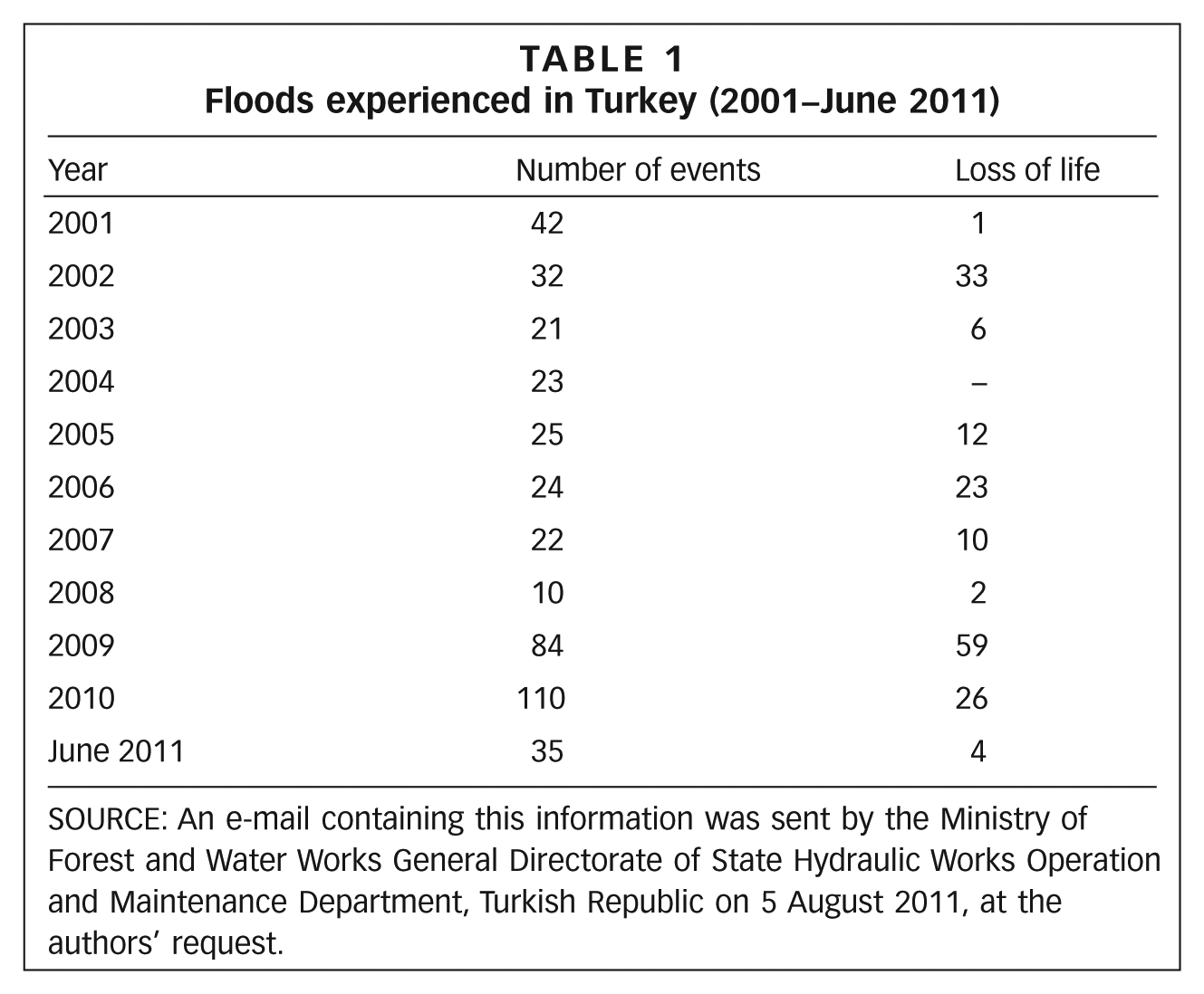
SOURCE: An e-mail containing this information was sent by the Ministry of Forest and Water Works General Directorate of State Hydraulic Works Operation and Maintenance Department, Turkish Republic on 5 August 2011, at the authors’ request.
The factors that cause damage following a flood disaster and that increase the risk of urban flooding in Turkey(8) include:
the narrowing of stream courses that pass through residential areas as a result of construction taking place alongside the streams;
unauthorized and inappropriate vent or bridge construction along the stream course;
embankment or inlay construction in the stream course without using proper techniques;
the disposal of building, industrial and domestic waste in the stream course;
covering the stream course;
illegal settlements that emerge spontaneously on slopes and roads and that are constructed with no regard for the discharge of accumulated waters resulting from rain;
illegal sand extraction from stream courses;
the growth of trees and bushes that narrow or block the stream course; and
unplanned and inadequate infrastructure in urban areas.
III. The City of Bursa
Bursa is located 155 metres above sea level and generally has a temperate climate. Based on a 52-year observation period, the average annual rainfall is 706 millimetres.(9) Bursa has experienced rapid industrialization, in-migration and urban expansion, and the increase in industrial investment in the city since the 1960s has been the main stimulus for rapid in-migration and population increase (Figure 1). The province of Bursa has the fourth largest population in all Turkey’s provinces.(10)
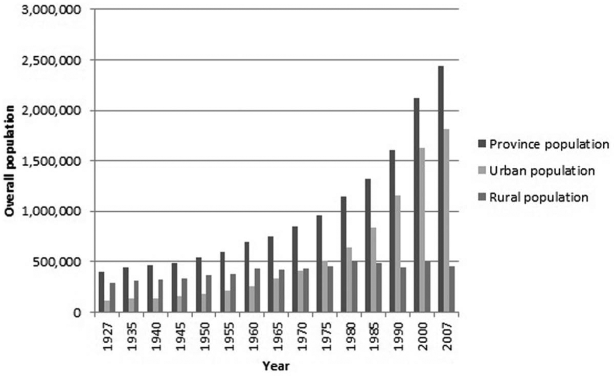
Bursa population growth 1927–2007
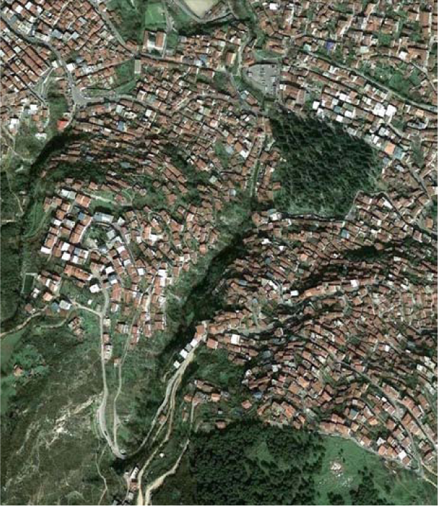
Housing production in the city has taken different forms, linked to the needs of different income groups. The housing needs of low-income groups have been met mainly through illegal construction, and houses are built close together with little or no space between them. They are generally multi-storey, with light and ventilation often only coming from the front of the building. New housing and settlements did not conform to any plan, provision for urban infrastructure is inadequate, and many units can only be accessed by narrow roads. Today, there are numerous illegal settlements on Bursa plain and in the southern part of the city on the outskirts of Uludağ mountain. Bursa has grown and expanded without the necessary infrastructure, and housing in many informal settlements has been constructed cheaply on public and private land that is occupied illegally, with no infrastructure and contravening zoning and building regulations. Some buildings are on land that is occupied legally but the structures themselves are illegal. However, property owners can get these units registered, through payments to the government during zoning amnesties. The two settlements chosen for this study, Alacahırka and Panayır, were formed with similar urban development over time (Map 1).
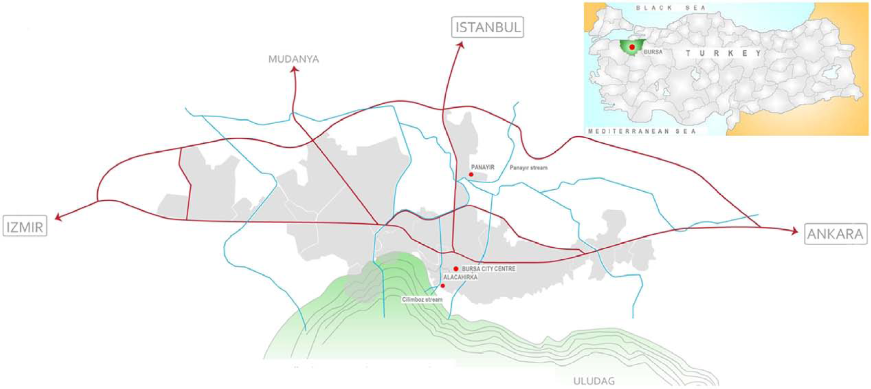
Bursa general site plan showing Alacahirka and Panayir quarters
IV. Research Framework, Methods and Data
This research, which focuses on Alacahırka and Panayır, was encouraged by the frequency of flood disasters in areas with similar characteristics (i.e. settlements of low-income families and informal/irregular settlements) in recent years. The central concern of the research was to identify the factors that increased the vulnerability of communities to flood disasters and how these could be addressed, emphasizing the role of the community in the design and implementation of disaster mitigation policies and methods. Within the scope of this research, priority was given to determining the factors that increased flood risks in settlements and to ensuring participation of the community at both individual (i.e. household), community (i.e. neighbourhood) and institutional level in developing a policy related to prevention and mitigation. In addition, this study also aimed to identify the measures that both central government and local governments should take regarding hazard mitigation, through a consideration of the existing legislative framework.
Although flood disasters affect a large area of Bursa, the research focused on interviews with households only in settlements that were most damaged by the flooding. The criteria for selecting the settlements were:
exposure to the negative impacts of flood disaster;
presence of low-income families;
illegal development inconsistent with zoning regulations (informal settlements);
high population density;
inner-city area; and
development on different topographies.
Based on these criteria, the districts of Alacahırka and Panayır were selected for study. Alacahırka is an historic inner-city district located on the outskirts of Uludağ mountain, whose development dates back to ancient periods in the history of Bursa. Panayır is a recently developed settlement located on Bursa plain and is an area of in-migration. It was previously a village on the outskirts of the city and became an inner-city district as Bursa developed into a metropolitan area.
Interviews guided by a questionnaire were conducted with members from 33 households, 23 in Alacahırka and 10 in Panayır. The questionnaire consisted of three parts. The first focused on basic information about the households. The second included questions about the settlement, the causes of the flooding there, the measures taken after the floods had occurred, the institutions or individuals responsible for mitigation of flood risk, and the measures that the community should take on this front. The third part focused on information about the houses.
The study also included an interview with the director of Provincial Disaster and Emergency Management, a representative of the central government, who was asked about flood-prone settlements in Bursa, how individuals there had been affected by the floods, what factors (economic, social, sanitary) increased individual vulnerability, and what intervention measures were taken. The director was also asked how community participation could be ensured in problem-solving during mitigation of the damage caused by the floods.
Data obtained from the interviews was analyzed using Microsoft Office Excel and statistical analysis software (SPSS). The results are presented in the tables and diagrams below.
V. Information from the Research
Alacahırka quarter, located in Osmangazi district in a valley divided by streams on the outskirts of Uludağ mountain, had 5,468 inhabitants in 2011.(11) Despite the fact that it is one of the oldest residential settlements in the city, there is much unplanned and uncontrolled construction activity in the area. (Photos 1a and 1b).
Aerial view of Alacahırka quarter
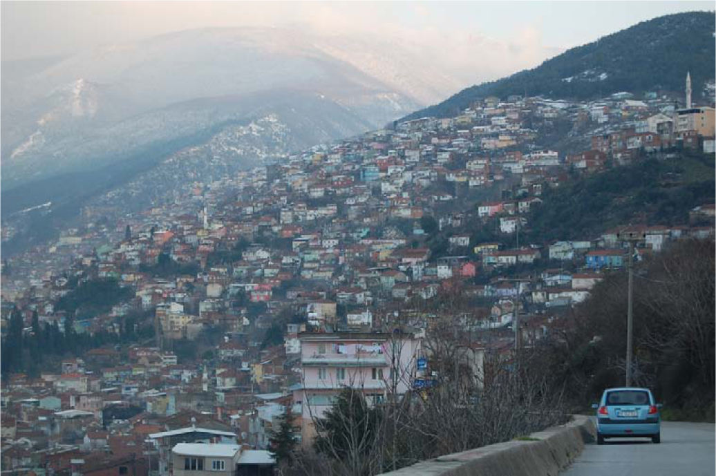
General view of Alacahırka quarter
Panayır quarter, located on a flat area known as Bursa plain in Osmangazi district, had 17,911 inhabitants in 2011.(12) As a result of industrialization in Bursa, this settlement area – where the majority of the housing stock comprises buildings two to three storeys high – was formed spontaneously by migrants approximately 30 years ago (Photos 2a and 2b).
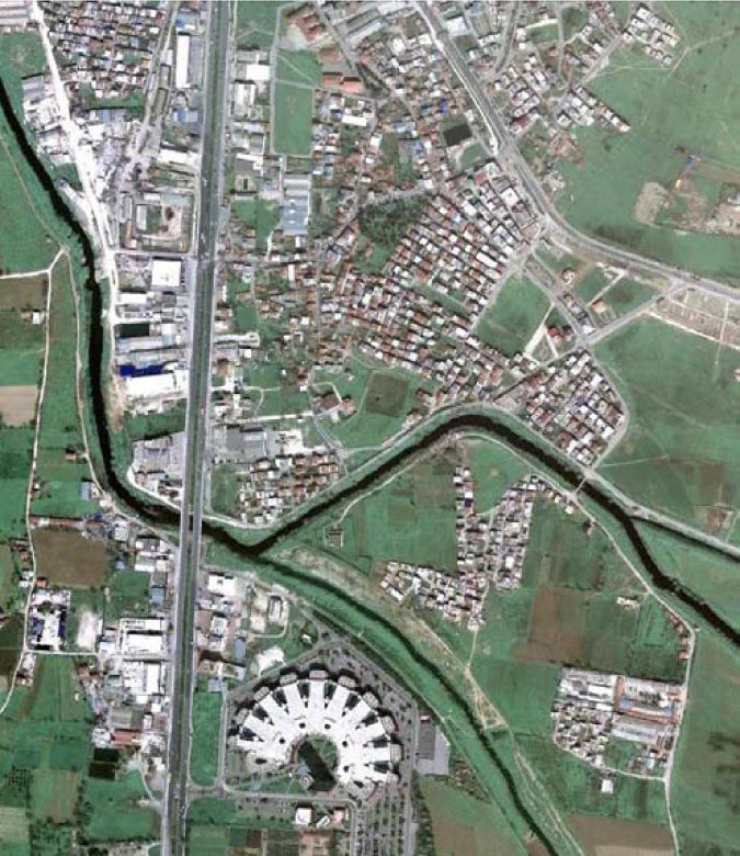
Aerial view of Panayır quarter

General view of Panayır quarter
a. Causes and results of floods in Bursa, October 2010
Bursa experienced two flood disasters in October 2010. The first took place on 14 October when torrential rain caused rivers to overflow. Bridges were destroyed, transport disrupted and many settlements were flooded (Photos 3 and 4). A bed-ridden patient whose house in Alacahırka was flooded lost his life.(13)
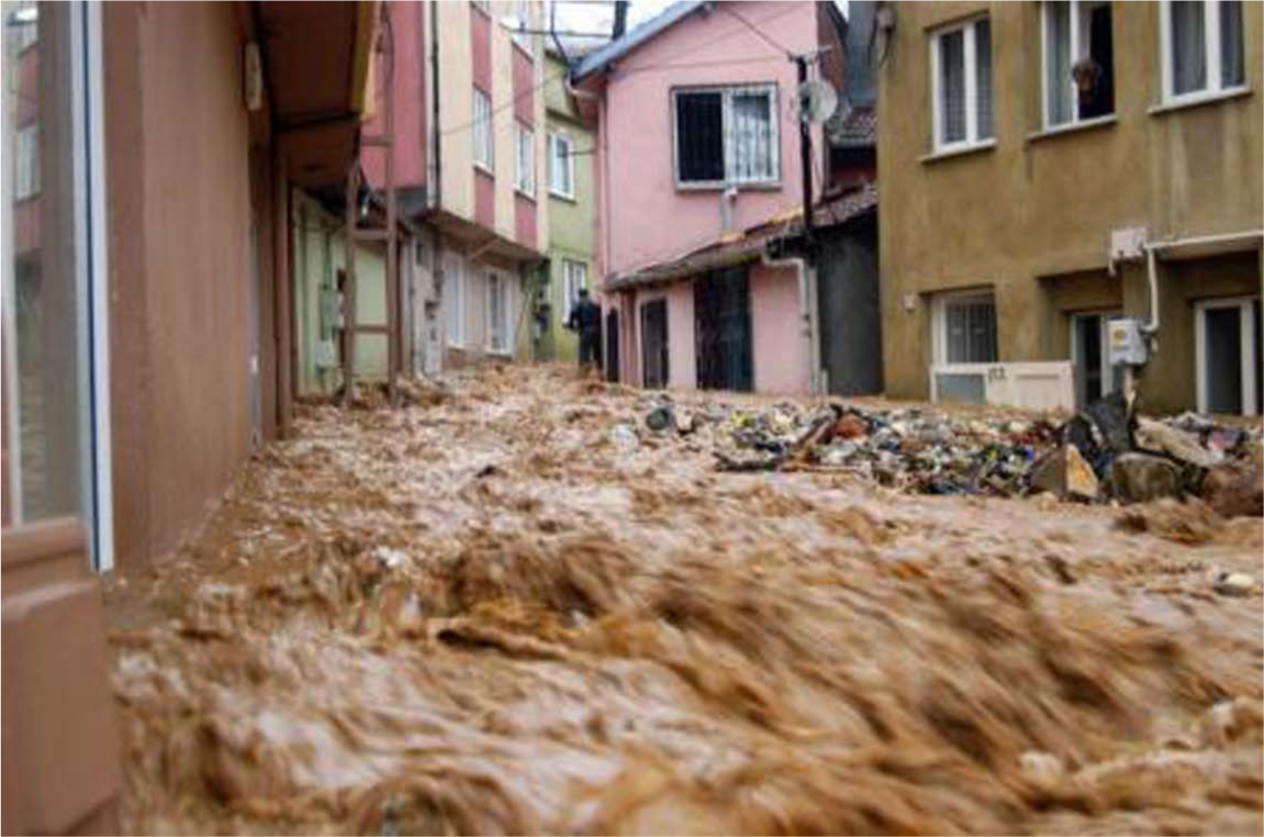
Affected houses in Alacahırka
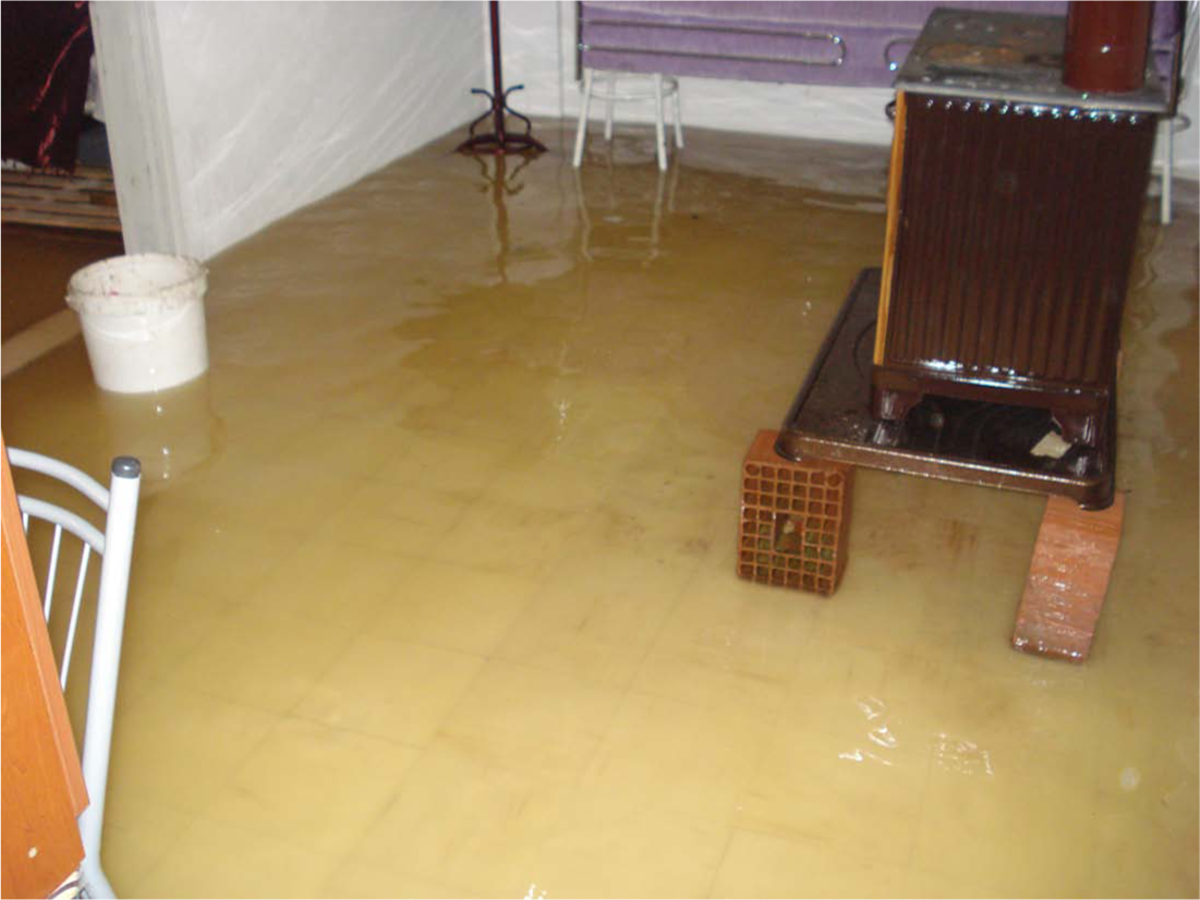
Affected house in Panayır
The second flood disaster occurred on 28 October. In addition to property damage in both Alacahırka and Panayır (Table 2), people experienced health problems and income loss, and schools were affected, as discussed in more detail later.
Results of the first damage assessment analysis for Alacahırka and Panayır quarters after the rain in Bursa province in October 2010
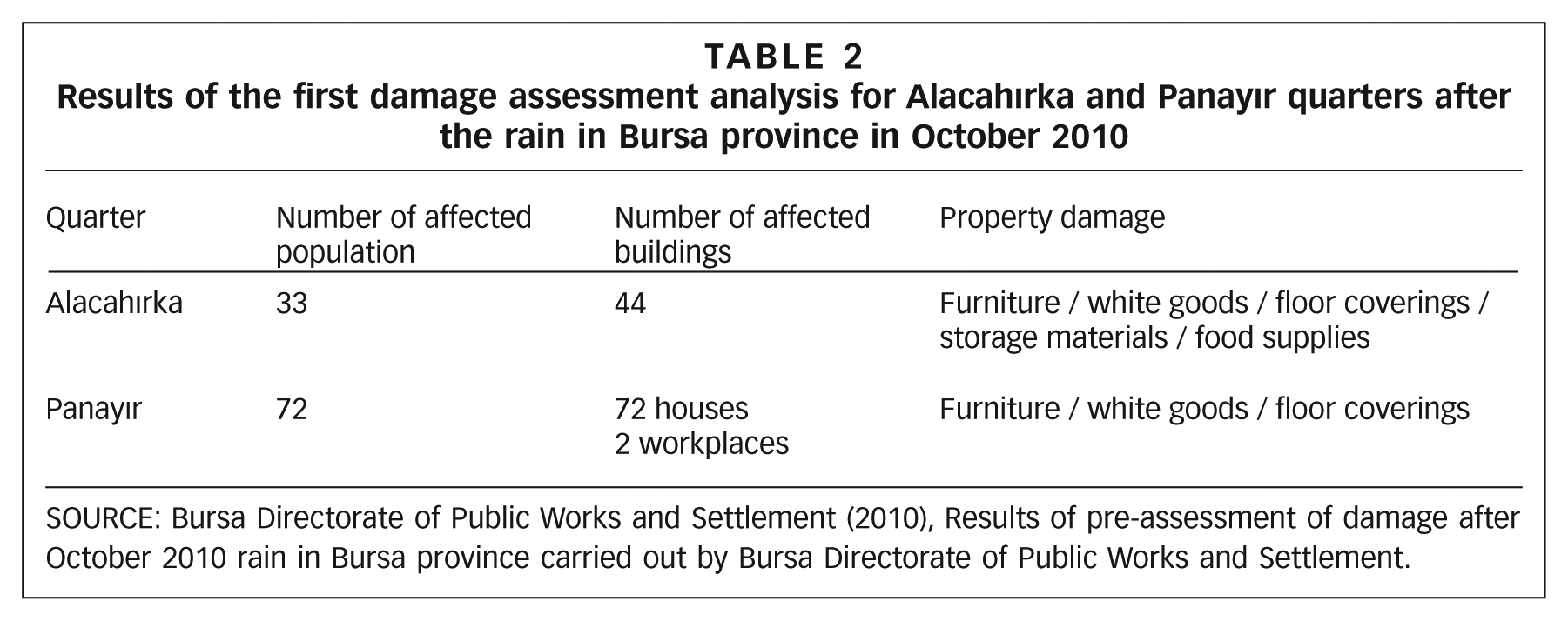
SOURCE: Bursa Directorate of Public Works and Settlement (2010), Results of pre-assessment of damage after October 2010 rain in Bursa province carried out by Bursa Directorate of Public Works and Settlement.
b. Questionnaire analysis
i. Results of questionnaire analysis carried out with central government
The provincial directorates for disaster and emergency (subordinate institutions of governorships in Turkey) have duties and responsibilities in the provinces under the Disaster Law (Act No. 7269) and the Law on Organization and Duties of the Disaster and Emergency Management Presidency (Act No. 5902). According to the director of the Bursa Provincial Directorate of Disaster and Emergency:
floods caused by heavy rainfall have become more frequent;
settlements where the majority of people have low and moderate incomes are more vulnerable to floods;
the most significant causes of vulnerability of citizens are illegal urbanization, which includes uncontrolled construction, and lack of infrastructure in informal settlements, especially settlements formed along stream courses;
after the floods, soil consolidation and landslides occurred, endangering the structure of buildings;
floodwater that entered the houses damaged furniture, white goods, floor coverings and carpentry works; Table 3 has a summary of the assessment of the damage that occurred in the districts of Bursa after the October 2010 floods, carried out by Bursa Directorate of Public Works and Settlement;
people took some precautions to reduce loss of life and property at individual and household level – for instance, they tried to remove floodwater from their houses and move their cars from the side roads to more secure places; and
the dissemination of disaster awareness is important for ensuring community involvement in taking measures to reduce disaster risks; besides increasing the effectiveness of control mechanisms (for example, those preventing construction along stream courses and on steep slopes), local authorities should focus on disaster awarenesss.
Results of first damage assessment analysis after the rain in Bursa province in October 2010
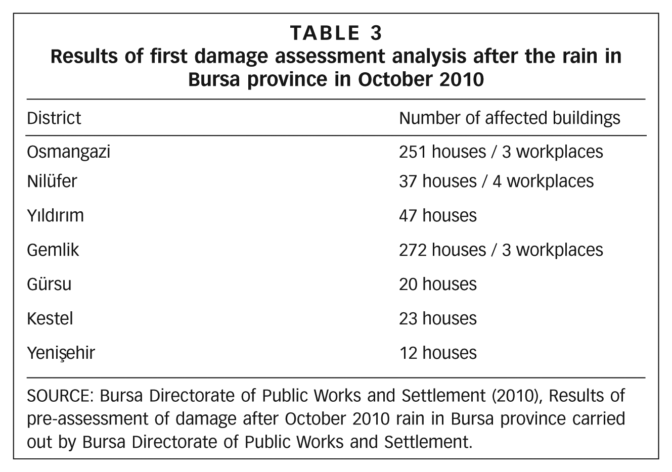
SOURCE: Bursa Directorate of Public Works and Settlement (2010), Results of pre-assessment of damage after October 2010 rain in Bursa province carried out by Bursa Directorate of Public Works and Settlement.
ii. Results of questionnaire analysis carried out with the public
A total of 33 household members were interviewed in Alacahırka and Panayır – including 16 women and 17 men. The analysis focused on those respondents who experienced the floods.
Among those interviewed, nine per cent have higher education, 30 per cent have secondary education, 55 per cent have primary education and six per cent are illiterate. Fifty-five per cent are employed or self-employed, 15 per cent are retired and 30 per cent are non-working (27 per cent housewives, three per cent unemployed). Ninety-seven per cent have social security insurance. Based on net monthly income, 37 per cent live on minimum wages, 21 per cent earn between 700TL and 1,200TL, 15 per cent earn between 1,200TL and1,500TL, 12 per cent earn 1,500TL to 2,000TL and 15 per cent earn 2,000TL or more. In Turkey in the first six months of 2011, the minimum net monthly wage was set at 630TL.(14)
Seventy-six per cent of respondents own the house in which they reside, 15 per cent live rent free and nine per cent are tenants. Eighty-five per cent of the respondents have lived in the same area for more than 10 years.
Fifty-eight per cent stated that they had constructed their own houses. Nine per cent live in one-storey houses, 40 per cent in two-storey, 33 per cent in three-storey, nine per cent in four-storey and nine per cent live in houses with five storeys or more. Fifty-five per cent of respondents live near a stream, 24 per cent live relatively close to one and 21 per cent are far from a stream. Forty-two per cent live in houses on flat terrain, 40 per cent in houses on a modest slope and 18 per cent on a steep slope. In 64 per cent of cases, the entrance door and windows of the house are above the road level, and 55 per cent find their home secure in terms of flood risk. Fifty-five per cent stated that there was no drainage system near their house and 27 per cent claimed that there was a drainage system but with insufficient capacity. Regarding the proportion of green area compared to impermeable surfaces, 68 per cent claimed that hard ground predominated, while 24 per cent said it was about equal.
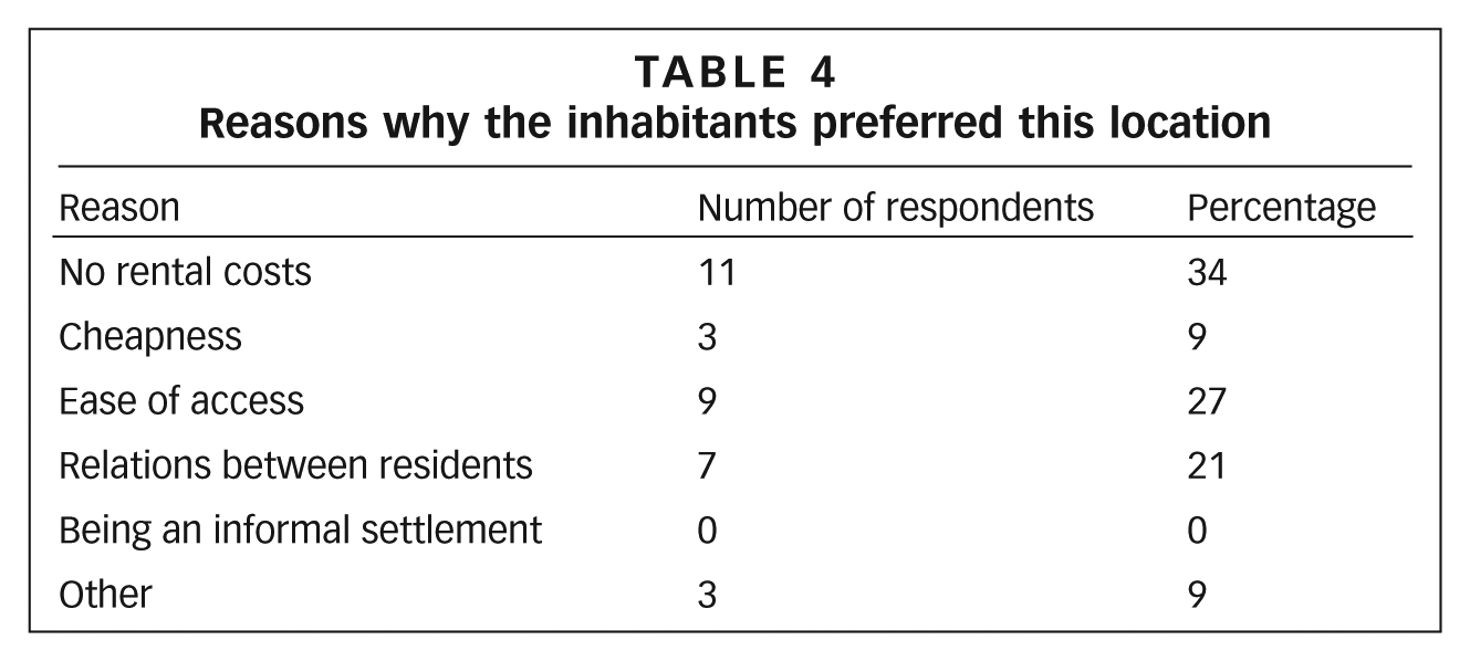
Sixty-four per cent of respondents had not experienced floods before; 46 per cent claimed that there was an increase in flood frequency, while 49 per cent saw no significant change. Respondents preferred to live in these settlements for a range of reasons (Table 4), including inheritance and the opportunity to live rent free in houses that belonged to relatives.
Reasons why the inhabitants preferred this location
Fifty-five per cent of respondents claimed that they were unaware of the risk of flood in their settlement area. Fifty-two per cent said that they would continue to live in their houses even if they knew the risks; low incomes were a significant factor in this. Respondents were asked to choose from a list the three most serious problems in the settlement, and they highlighted unplanned/informal settlement, flood risk, and poor quality and inadequate roads (Figure 2) (Photos 5a and 5b).
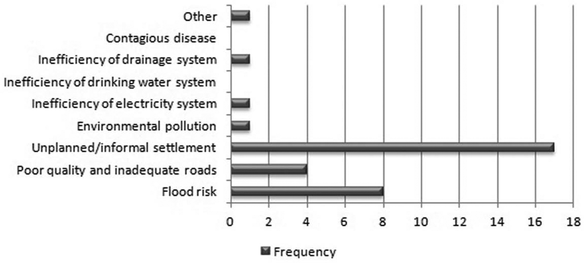
Problems/issues regarding the settlement
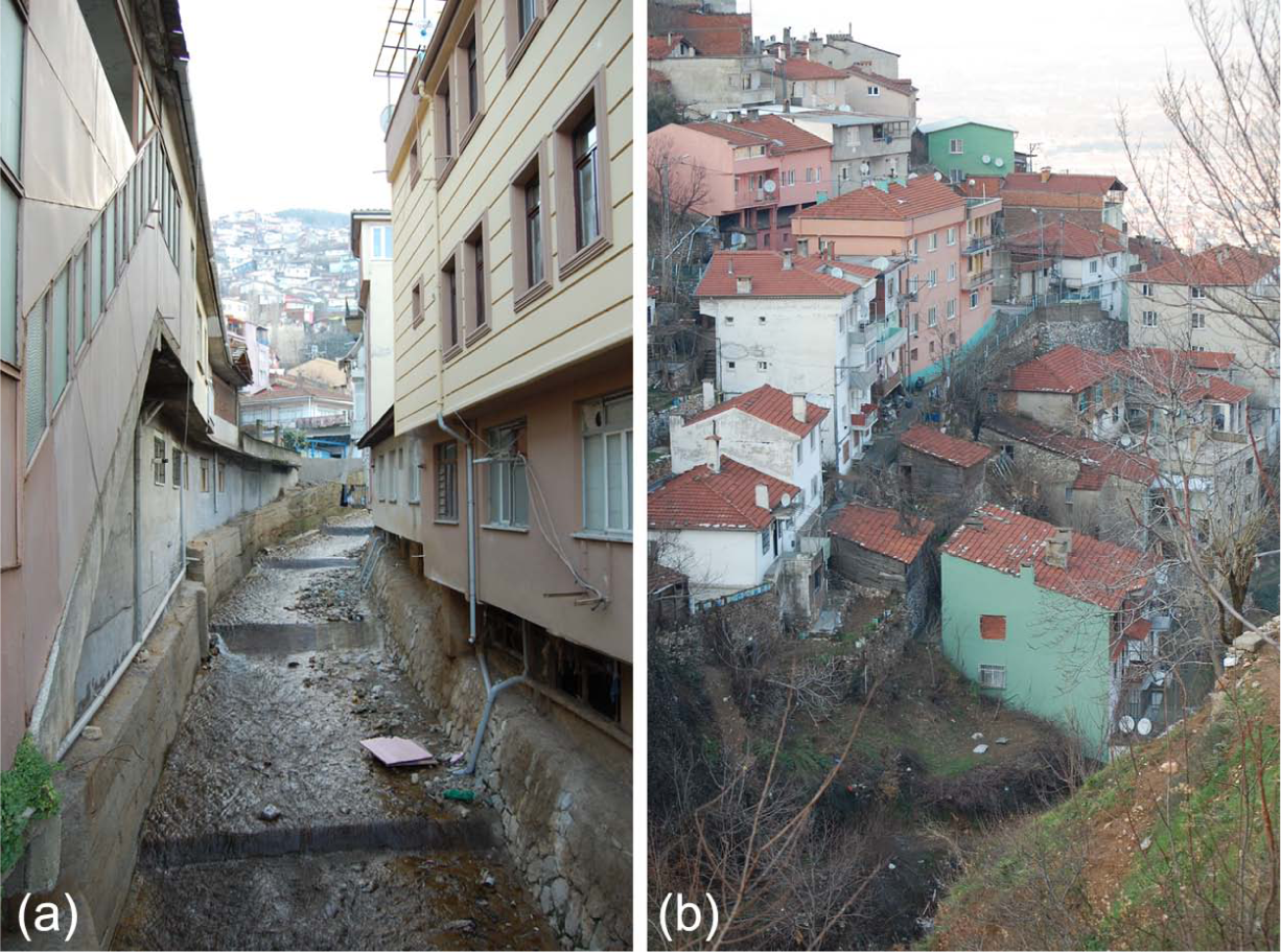
Examples of the existing problems regarding the stream
When asked about the relative importance of a range of reasons for the increase in damage caused by flooding in their settlement area, respondents listed sudden severe rainfall, unplanned/informal settlement and the presence of extensive amounts of rainwater and surface run-off (Figure 3).
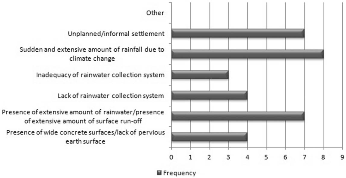
Factors that increase flood damage
Because of the sudden and unexpected increase in the severity of the rainfall during the night, 52 per cent of respondents could not prevent floodwater entering their homes. Water also rushed in through bathroom and toilet drains. Respondents identified the prevention measures that they took individually and with their families to prevent this:
using carpets, cushions and clothing to shore up doorways;
placing sandbags in front of doors;
blocking door openings with bricks; and
changing the direction of floodwater using planks.
Only 18 per cent of the respondents interviewed reported that they took precautions as a community, for instance constructing barriers on the roads in the direction of the flow of water, using bricks, stones and pavement border stones, to regulate the water flow. The remaining 82 per cent claimed that they couldn’t help each other due to the high level of water and the need to deal with the impact at home.
When asked about who was responsible for taking measures to mitigate flood damage, most respondents claimed that this was the responsibility of the municipality and the governorship (Figure 4) – in particular the State Hydraulic Works (DSl.).
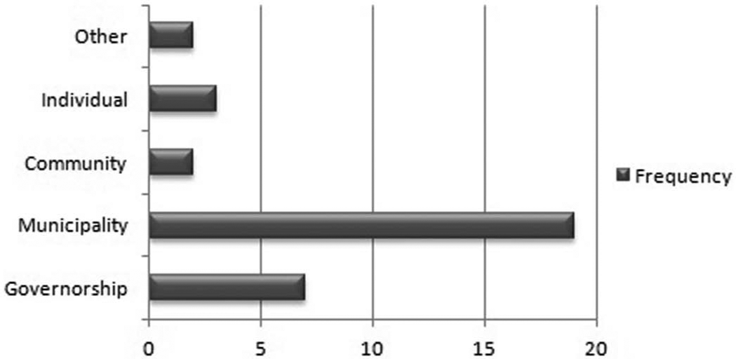
Responsibility for taking measures for flood damage mitigation/preparedness
Sixty-four per cent of respondents did not suffer any health problems as a result of the floods; the remainder claimed that they caught cold from the water that entered their house or became ill during the evacuation of the water. One respondent was paralyzed as a result of the sudden floods and another had a heart attack. The major problems experienced after the floods had to do with the impact on drinking water and drainage (Figure 5).
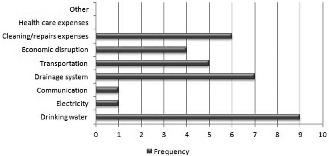
Socioeconomic issues/problems experienced after a flood disaster
Sixty-one per cent of respondents said that they received no help from anybody else in protecting their property or in escaping the floodwaters. In most cases, they made efforts to save their own lives and properties. Twenty-four per cent claimed that they had support from their families, 12 per cent were supported by neighbours and three per cent by central or local government. Ground-floor residents in multi-storey houses were especially affected by the floods and received help from other family members or neighbours living on upper levels.
Seventy-nine per cent of respondents said that they had made no preparations to mitigate or prevent flood risk, and despite the fact that a flood disaster has been experienced, preparedness plans are still not in place. Correlation analysis carried out within the scope of the study indicated that a high income level was related to higher levels of awareness of damage mitigation and preparedness (R=-0.345, p<0.05). Length of stay in the settlement and property status were also positively related to attitudes, although not significantly. People who made no preparations were questioned as to why. Among the responses were the belief that floods would not occur again and that nothing effective could be achieved.
Among the respondents, 18 per cent claimed that measures had been taken by central or local government to mitigate damage before the floods occurred – for example, the collection of household waste and the improvement of streams and stormwater drains on arterial roads (Figure 6). Works that were carried out by central and local government after the floods had occurred are depicted in Figure 7.
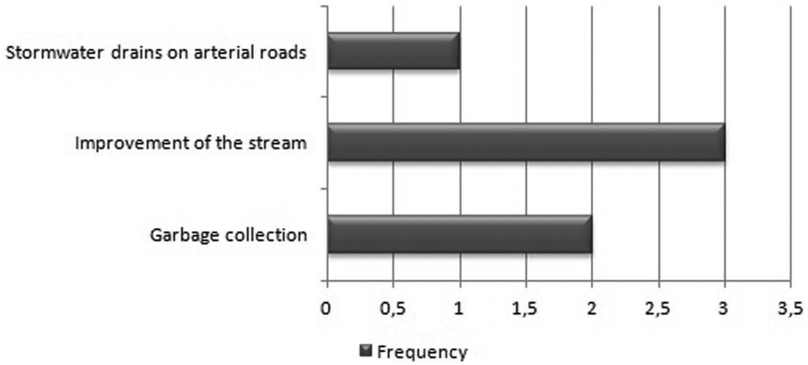
Measures taken by central or local government to mitigate damage before the flood occurred
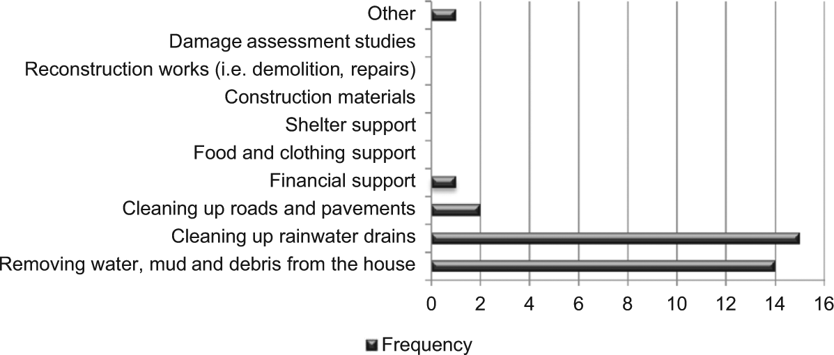
Respondents’ reports on works carried out by central and local government after a flood disaster
Respondents were questioned about their suggestions for measures to be taken before a possible flood in order to avoid damage. Their answers were as follows:
prevent rapid urbanization and population increase;
improve settlements that have a high flood risk;
prevent informal (illegal) construction; ensure and increase the functioning of control mechanisms with no concern for local elections;
avoid the construction of houses on the banks of rivers and streams; identify locations where people can live without exposure to flood risks and damage;
consider the height of the bridges to be built over the streams;
keep domestic waste and construction debris out of streams;
clean out and improve the streams regularly;
widen the stream courses;
emphasize environmental hygiene; collect garbage regularly; provide different solutions for garbage collection in settlements such as Alacahırka that have steep slopes and roads too narrow to allow access by trucks;
slow down the flow of water by constructing dams in specific places;
construct stormwater collection systems or improve existing ones by widening them;
separate and improve the sewage system and stormwater collection channels;
install check valves to avoid overloading the sewage system ;
clean on a regular basis the vertical iron grilles that are installed in streams in the immediate vicinity of bridges and that are of a similar height to them; they stop the flow of stones that enter the streams after any rain, and also stop the flow of waste into the streams;
ensure the implementation of the decisions of former mayors by their successors;
control the water levels in dams by opening the valves at regular intervals and draining water to a risk-free level in the event of an increase and sudden discharge during any high rainfall; and
undertake necessary maintenance, repairs and clean-up without waiting for complaints.
These responses can be grouped under three main headings. The first is the requirement that municipalities take responsibility for infrastructure improvements and for the maintenance and regular cleaning/clearing of the river. The second is the application of regulations controlling or preventing the construction of buildings that increase the risk of flood disaster. The third is continuity in municipal government responses, even as administrators change.
c. Damage assessments carried out by government after the 2010 flood disasters
Following the two floods in Bursa, damage assessments were carried out by central government within the context of the Disaster Law (Act No. 7269) and the Law on Organization and Duties of the Disaster and Emergency Management Presidency (Act No. 5902), and the buildings at risk in all of the settlements that were exposed to floods were identified. Financial support was provided to those who had experienced financial loss. The local government (Bursa metropolitan municipality) also started iınvestigating the expropriation of those houses located along the Cilimboz stream in Alacahırka that had been flooded. Initially, demolition works began in an area where 22 buildings at high risk had been expropriated (Photos 6a and 6b). Once the demolition works are completed, the banks of the stream will be turned into a recreation area.
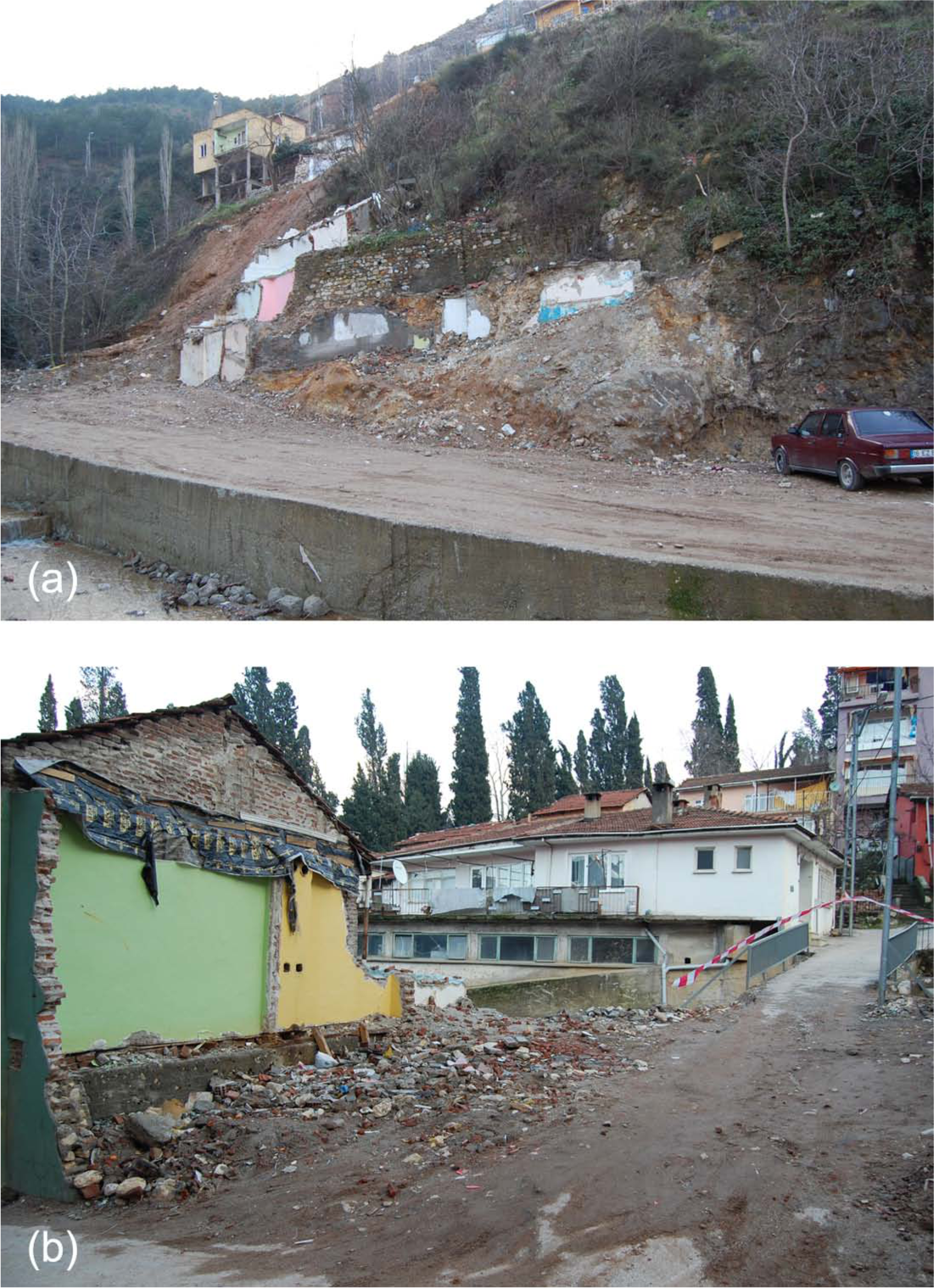
Demolition work in settlements where buildings are expropriated
Officials of the Etude Project Department of Bursa metropolitan municipality, who are responsible for carrying out the design and implementation of the existing development plan, described the measures that were being taken. Expropriation investigations are being undertaken by the Bursa Water and Sewerage Administration (BUSKI) of the metropolitan municipality, since the main concern is the river and its environs. Buildings that are within the boundaries of a flood area, and that have been damaged by the floods and are at risk, are deemed illegal. Owners of buildings that have been expropriated are paid the land ownership price rather than the current market value, and also debris compensation. A small number of homeowners have appealed to the courts because they thought the compensation for expropriation was inadequate. However, the courts have rejected their objections and upheld the amounts defined by the administration. Owners of expropriated houses have used the compensation to move to other residential areas.
The administration has declared that the regulation of the river and surrounding areas at risk of flooding has been carried out in accordance with the relevant legislation. Once the buildings in the flood risk area have been demolished, the evacuated area has been planned as a greenbelt and recreation space according to the development plan, and implementation has started. This alternative space is expected to provide relief within this district with its dense urban fabric. At the same time, within the framework of the annual investment programme, a stream improvement project has been approved by BUSKI and DSI and expropriation measures have been implemented for the evacuation of buildings located in areas at risk of flooding. In addition to responding to the risk of flooding in the area, an urban transformation to improve quality of life has been targeted, with effective participation of the community, within the scope of the urban transformation law that has currently come into force.
During the interviews carried out within the scope of the questionnaire, respondents who were affected by the floods but who still lived in the area claimed that they approved of the demolition of buildings at risk organized by the local government as it increased the safety of the settlement. However, as a result of the demolitions, people whose homes had been destroyed were displaced, causing feelings of isolation; this was emphasized, in particular, by senior citizens who were born, grew up and had lived in the same area all their lives and they complained about being obliged to leave their long-time neighbours. Some of the respondents also suggested that land values would increase with the implementation of new expropriation arrangements and that this would have an impact on their existing way of life.
VI. Evaluation of Questionnaire Analysis
The case study areas had not experienced any flood disasters prior to October 2010. In previous years, after sudden intense rainfall, waters had flowed freely and didn’t cause any flooding. Table 5 outlines the main reasons for the floods experienced in Alacahırka and Panayır in 2010.
Basic causes of the flooding experienced in settlements
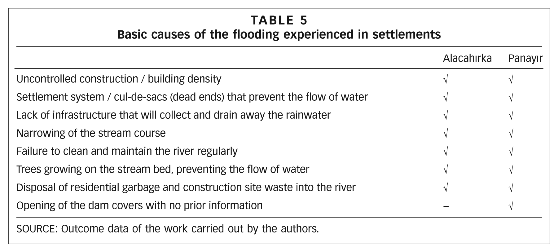
SOURCE: Outcome data of the work carried out by the authors.
Measures to be taken in response to these problems include the following:
In the short term, all the trees that are growing within the watercourse of the Cilimboz stream in Alacahırka and the Nilüfer stream (beginning from Demirtaş dam) in Panayır should be removed by the local administration to facilitate the free flow of water. In addition, all the rubbish and construction debris in both districts should be removed.
In the medium term, following the clean-up process in both districts, stream improvements should be organized by the municipality and there should be regular, ongoing maintenance and provision for clean-up.
In the long term, as these districts are located in valley and hillside areas that are at high risk in terms of construction and urban pattern, exceptional land development measures, including a reduction in population density, and reinforcement of the existing buildings should form part of urban disaster prevention planning. Disaster-sensitive urban transformation studies should be undertaken in these settlements to address uncontrolled construction and a lack of administration and communication.
Although emergency response should be the responsibility of the administration, long-term prevention studies should be designed so as to be dominated by the views of the people living in those areas.
VII. Conclusions
Studies of disasters in Turkey have focused mainly on post-disaster responses. However, where floods are concerned, disaster management should focus not only on evacuation and recovery; rather, priority should be given to protecting people from possible flood hazards and to minimizing existing disaster risks before disasters occur. This requires research on how to minimize flood hazards and their impacts, as well as increasing the disaster awareness of individuals, families and institutions and ensuring their preparedness.
In settlements with high levels of risk from natural disasters (earthquakes, floods, etc.), as in the case of Bursa (where 60 per cent of buildings are not constructed according to zoning regulations), urban transformation studies should be carried out in order to increase the liveability and safety of urban space. Such research, with a focus on improving the quality and safety of urban settlements, should have a participatory approach. This has to go beyond considering zoning conditions and building density during the reconfiguration of urban areas. It needs to take into account local sensitivities and urban identities – including social and cultural aspects – in ways that develop and revitalize the residential areas. Participation should develop a common understanding, with the effective inclusion of local people as well as central and local government and non-government organizations. Projects and planning studies need to draw on users’ preferences and local people’s knowledge, experiences and customs.
Community participation in these studies is essential. In order to reduce the effects of floods in the short and medium term, clean-up and improvement of the streams should be carried out consistently by the administration, and infrastructure improvements should be accelerated.
Besides those studies carried out by the administration, a fundamental study that should be carried out for the mitigation and prevention of the negative effects of natural disasters relates to developing risk perception (hazard and vulnerability perception) in the community. In other words, each community should develop an awareness of its responsibilities in disaster mitigation and prevention (disaster preparedness activities of individuals, families and the community; willingness to participate in risk mitigation studies; support for risk reduction policies). If the community has a good risk perception, it is more likely to become disaster resistant. The questionnaire responses show that individuals and the community expect the state and the municipality to take on required mitigation and preparedness. In order to achieve a resistant community with disaster awareness, community involvement is a priority. The initial step in the mitigation of vulnerabilities of people living in urban areas is to develop an accurate perception of disaster risks as a continuation of daily hazards and risks, and to establish the links between them (disaster risks and daily hazards and risks).
As long as individuals, families and institutions are unaware of the hazards and risks that endanger them in their daily lives, and are not encouraged to mitigate the dangers and risks that emerge as a result of these hazards, it will be difficult to achieve community participation. People will not be convinced of the need to to be actively prepared for emergency interventions unless they believe that they have the necessary resources and institutions to change the basic factors that increase their vulnerability, which include unhealthy environmental conditions and low construction standards.(15)
The fact that there has been no provision for reducing flood risks despite the impacts of the recent flood disasters shows the need to develop ongoing community disaster awareness and training programmes. Local governments should contribute to these programmes and should enhance and develop communities’ capacities to undertake these activities. The training programmes should provide communities with detailed information on flood damage mitigation and prevention methods, and emphasize that actions can be taken to increase risk perception and reduce damage and that adaptive capacities can be enhanced. Communities should be trained in basic measures to minimize casualties and injuries. Ensuring cooperation between local and central administration and universities in the provision and implementation of these programmes will enable the use of available resources and access to diverse individuals (women, children, elderly and disabled people). A disaster damage mitigation training centre is being established in Bursa that will enable people to better understand disasters such as earthquakes, storms, strong winds, fires, landslides, floods, etc. Using simulation techniques, the aim is to introduce appropriate methods for surviving with minimum damage after a hazard, to raise awareness and to train the community.
The household questionnaires suggest that high levels of education and income are significant indicators of disaster preparedness. Therefore, any efforts to increase the adaptive capacity of people and create a resilient community that have a direct relationship with education and income levels should be considered as part of the development plans.
Public participation should be ensured in any future studies. In this way, a liveable and healthy city (the fundamental right of individuals) can be created in the context of sustainable development/urban growth, a city that is also disaster resistant and that can survive potential natural disasters with the least damage.
Footnotes
1.
Gülkan P, M Balamir and A Yakut (2006), “Strategic principles in disaster management: an overview of policies in Turkey and in the world”, Strategic Principles in Disaster Management, JICA Turkish Office Edition No 1, Ankara (in Turkish), pages 19–42.
2.
United Nations World Conference on Disaster Reduction (2005), Hyogo Framework for Action 2005–2015: Building the Resilience of Nations and Communities to Disasters, available at ![]() .
.
3.
Allen, K M (2006), “Community-based disaster preparedness and climate adaptation: local capacity-building in the Philippines”, Disasters Vol 30, No 1, pages 81–101.
4.
Jahangiri, K, Y O Izadkhah and S J Tabibi (2011), “A comparative study on community-based disaster management in selected countries and designing a model for Iran”, Disaster Prevention and Management Vol 20, No 1, pages 82–94.
5.
Pandey, B and K Okazaki (2005), “Community-based disaster management: empowering communities to cope with disaster risks”, UNCRD, available at http://www.unpan1.un.org/intradoc/groups/public/documents/un/unpan020697.pdf; also Davis, I (2004), “Issues and challenges for community-based disaster management – envisioning the UN World Conference on Disaster Reduction”, available at ![]() , 20 pages.
, 20 pages.
6.
Kadıoğlu, M (2008), “Basic principles of modern, comprehensive disaster management”, in M Kadıoğlu and E Özdamar (editors), Basic Principles of Disaster Risk Reduction, JICA Turkish Office Publication No 2, Ankara, pages 1–34.
7.
Karancı, A N (2007), “Mitigation of earthquake damage and preparedness: the significance of community involvement”, Middle East Technical University, Disaster Management Implementation and Research Centre, Ankara, accessed 10 June 2010 at ![]() .
.
8.
Ergünay, O (2011), “The project of flood risk mitigation in areas subject to flooding in GAP (Southeastern Anatolia Development Project) region, accessed 18 July 2011 at ![]() .
.
10.
12.
See reference 11.