
Abstract
Disaster risk reduction (DRR) has become a major area of concern in the wake of increasing numbers of disasters. With rapid urbanization, both globally and locally, attention to the challenge of disaster risks has turned to urban settlements, where high densities and settlement patterns can, and do, create vulnerabilities. This paper presents an analysis of the hazards and risks that the town of Karonga in Malawi faces from earthquakes, floods, strong winds and drought, and considers locally appropriate methods to address these. It also discusses the limits of collaborative urban planning in this context, especially in light of the absence of an elected local government. Lessons from Karonga can inform the development of effective DRR mainstreaming tools in countries reliant on external support.
I. Introduction
Disaster risk reduction (DRR) in urban areas has become a major concern of planning in the wake of an increasing number of geological and climate-related disasters. Rapid urbanization, especially unregulated growth, can lead to human and property vulnerability to hazards.(1) The Hyogo Framework of Action (the UN’s 10-year plan to build resilience to disasters) and the United Nations Office for Disaster Risk Reduction (charged with supporting its implementation) both seek a paradigm shift from “preparedness and responses” to “risk reduction and management”. This is achieved by mainstreaming attention to disaster risks in policy and planning.(2) The main determinants of disaster risk are the magnitude of hazards, exposure to the hazards and vulnerability to the impacts.(3) These factors are often intensified in cities because of their concentration of people and assets and often because of their location in and expansion into hazard-prone areas.(4) To date, most studies of cities’ vulnerability to climate change and other hazards focus on cities with more than one million inhabitants.(5) Small towns in low-income nations are often overlooked despite their exposure to environmental hazards and rapid growth.(6)
This paper analyzes a planning process in relation to potential disasters for the town of Karonga, one such small urban centre in Malawi. Weak adaptive capacity here was exacerbated by the absence of a functional local government, which is recognized as a key factor that can increase the risks faced by small towns.(7) In Malawi, despite constitutional requirements, the absence of any local government since 2005 has negatively affected provision for urban planning and other services that are arguably the main tool to reduce disaster risks.
The planning process discussed here involved engaging communities, through transect walks and gender/age-based focus group discussions, in the collection of otherwise undocumented data on disaster events, their causes and impacts. It also provided the data to allow a mapping of major disaster hotspots, culminating in a revised plan for the town. The findings of the paper indicate, however, that in the absence of a local council, implementation has remained unrealistic. This suggests that attempts to mainstream DRR into urban planning can be rendered futile without a functional local government.
II. Local Governance in Malawi
Malawi reintroduced decentralization after multi-party elections in 1994, and a decentralization policy was developed that called for the devolution of many roles and responsibilities to the lowest level. In order to promote and enshrine popular participation in development planning, a local government law was passed in 1998. The first elections of local councillors were conducted in 2000; however, despite the constitutional provision for elections, no further local council elections were conducted after the inaugural councillors’ term expired in 2005. The reasons for this were two-fold. First, most of those aspiring to become councillors were considered to have too low a level of education to contribute meaningfully to the development challenges of local government. The small honorarium of about US$ 20 per month meant that many better-qualified citizens were not attracted to the position. (Members of the national parliament, by contrast, with comparatively less demanding roles, earned more than US$ 1,200 per month.) The majority of councillors were retired teachers or local residents who had not completed secondary school.
The second reason, put forward by the government, was that it lacked sufficient funds to conduct local elections. Donors offering adequate funding to enable the holding of tri-partite national elections (in which citizens vote for the president, members of parliament and local councillors at the same time) in 2009 were turned down by President Mutharika on the pretext that voters would be confused on account of the high illiteracy levels in the country. Political leaders considered the decentralized local structure unnecessary, or openly feared competition from local councillors.(8) To ensure that no council elections took place, the government made several amendments to the Local Government Act in 2009 that allowed national assembly members to become voting members in local councils and made President Mutharika alone responsible for deciding if or when local elections would be held. The Malawi government dissolved all town councils (except in the president’s home town of Luchenza), ostensibly because they were a drain on national resources. Since the dissolution of town councils left a governance vacuum, ad hoc committees involving civil servants, chiefs and NGO staff were established to replace elected councillors. But this rendered all major local decisions, including budget approvals, planning approvals and the collection of property taxes illegal.(9)
In Karonga, a decision to revise the town plan was ultimately made at one such ad hoc multi-sectoral stakeholders’ meeting organized by the Department of Disaster Management Affairs (DoDMA) to review the impact of disasters that occurred in the town in 2009. The planning process itself was spearheaded and funded by UN–Habitat. Among the major participants were representatives of the national government departments of physical planning, education, agriculture, housing, local government, health and rural development as well as NGOs such as the Red Cross. Having DoDMA as lead organization in the process was testimony to the fact that the local government of Karonga town was ill-equipped to manage urban development. As noted elsewhere, removing responsibility from the local level may cause or exacerbate risks.(10) In the absence of local councillors, no mechanism exists for community mobilization around local economic development or, in this case, to raise the profile of local concerns about key local hazards. Mainstreaming DRR and environmental planning, in line with the Hyogo Framework of Action and Local Agenda 21, cannot be realized effectively at the local level in this situation. The passing of the tri-partite elections bill by the government of Joyce Banda in 2013, after the death of President Mutharika in 2012, gave hope for the restoration of local governance as new councillors would be recruited for the first time since 2005.
III. Hazards and Disasters in Karonga Town
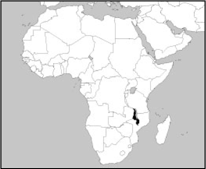
Karonga is a border town that has been in existence since the 1880s (Map 1). It grew as a centre on the slave trade route to the Indian Ocean, and later as a European settler trading centre following the completion of the road linkages between Lake Malawi and Lake Tanganyika.(11) The first colonial administration was established near the town in 1904, and during the First World War Karonga became an important battleground between the British and German armies. The development of German-funded secondary towns and flood control projects between 1979 and 2003 and the opening of a uranium mine nearby at Kayelekera in 2009 have been the major drivers of the town’s more recent growth. Its population of 50,000 is projected to reach 72,000 by 2022.(12)

Map of northern Malawi showing the town of Karonga
The town, which covers nearly 4,400 hectares, is located along Lake Malawi at the mouth of the North Rukuru River, within the Karonga Basin, at between 445 and 550 metres above sea level. Karonga town and the surrounding areas are vulnerable to earthquakes, floods, strong winds and drought and the locality registered the largest number of disasters in Malawi between 1946 and 2008.(13) Particularly serious were the floods in 1979–1980, which damaged most of the old town and led to the relocation of the commercial centre to the current site, and the earthquakes in 2009, which resulted in death, injury and extensive damage.
A number of local factors exacerbate the risks. The low altitude of the town, its high water table and the increasing amount of construction in low-lying areas raise the potential for damage from flooding. The low quality of local buildings also increases vulnerability to disaster impacts. More than half of the properties are built of low-quality materials such as thatch, mud and wattle. They may have, at best, a cement floor or iron sheet roof.(14) In many cases, they are occupied by squatters living on land that is unsuitable for housing and that is especially vulnerable to flooding. The lack of a solid waste disposal facility and adequate ways of dealing with liquid waste add to the problems.
IV. Planning for Disaster Risk Reduction
a. Disasters and the planning process
The first plan for Karonga town was prepared in 1972 and revised in 1975. Following the flooding in 1979–1980, which destroyed most of the commercial area along the lakeshore, major planning activities were undertaken to implement flood control infrastructure, including the construction of a dyke along the North Rukuru River and of artificial channels in town to collect and channel flood and stormwaters to the lake. The town was subsequently declared a statutory planning area in 1991(15) in line with the new Town and Country Planning Act (1988).
The current planning initiative was in response to the earthquakes in 2009 and the floods in 2011. The earthquakes, which occurred between 6 and 19 December, registered magnitudes of 5.0, 5.9, 6.2 and 7.6 on the Richter scale.(16) Although the epicentre was 30–50 kilometres west of the 120 kilometre-long Livingstone fault line (eastern shoreline)(17) and away from Karonga, the earthquakes caused lateral and vertical displacements of up to 10–13 centimetres, killed six people, injured more than 300 and damaged 1,100 buildings (many outside town) as well as infrastructure, including the new M26 road to Chitipa, then under construction. The dyke constructed after the 1980 floods was also damaged, leading to subsequent flooding and property damage in 2011.
Assessment exercises by government officials after the earthquakes found that most of the buildings that had collapsed had not followed the formal planning approval process. Consequently, the Guidelines for Safer House Construction Technical Manual was developed to help households follow basic building codes. The damage to property as a result of the flooding in 2011 gave the opportunity to start a review of the Karonga urban plan. Due to the absence of a local authority to undertake or lead the planning exercise, the central government’s Department of Physical Planning took on the responsibility.
Information for the planning exercise was sourced using a community resilience and vulnerability assessment tool specially developed for Karonga by the local UN Habitat Office and Mzuzu University. This involved discussions that included both men and women and different age groups to develop events calendars, problem and solution trees, hazard-ranking and hot-spot mapping for each neighbourhood. This allowed the planners to mainstream local knowledge, experiences and perceptions on, and responses to, hazard trends in the plan. Based on this, the planning team prepared a draft plan for debate with communities. Five feedback sessions were held with communities and the district executive committee (an ad hoc structure that took the place of elected councillors). The team finalized the plan and presented it to the communities for further input before the formal approval process started. Despite the lack of depth and time, the tool stimulated community awareness of hazards and provided experiential learning on planner–community collaboration in the planning process. It is worth mentioning that by the time the draft plan was ready in May 2013, three years had passed in collecting data, digitizing maps and holding meetings.
b. Planning strategies
As in other urban centres in Malawi, growth in Karonga town is largely informal except in the commercial centre (CBD). Considering its strategic location on the route to the port of Dar es Salaam in Tanzania and its ranking as the sixth largest urban settlement in the country, it is especially important that any hazards that threaten the town are addressed. The main strategic aim of the plan review was to reduce vulnerability and prevent future disasters from earthquakes, floods, strong winds and drought by creating and sustaining an urban environment whose physical and social development was orderly, coordinated and to appropriate standards. To achieve this, the plan made several proposals that involved a compromise between mixed development and densification on the one hand and urban sprawl or boundary extension on the other. It advocated a compact urban settlement within identified safe localities, which would be realized by reducing plot sizes for various uses to minimum required standards. Land for urban agriculture would be reserved especially in the marshy areas along the lakeshore. To allow voluntary relocation from high-risk areas such as the artificial channels and the floodwater-holding zone, the township boundary, currently at 4,400 hectares, needed extending. Any new building would be allowed only in low-risk areas. Furthermore, noting the national failure to develop building codes and enforce planning standards, the Guidelines for Safer House Construction Technical Manual developed for Karonga would be promoted with institutions and the general public. The manual promotes building standards and retrofit measures that would enable existing buildings to withstand the impacts of earthquakes and strong winds. For instance, the manual recommends removing gables and replacing them with hipped roofs; applying cement render to walls; replacing internal walls that support roofs with timber trusses; fitting roofs with diagonal bracing on inside purling; siting buildings away from trees; and repositioning doors and windows.(18)
To achieve the plan’s objectives, specific actions were proposed. Some were soft projects – for example pre-disaster awareness and sensitization for communities to change mind sets on the seriousness and impacts of hazards, which is essential for minimizing risk and for recovery response.(19) Also proposed were an early warning system and sustainable forest management outside the town, especially in the catchment area of North Rukuru River to the west, as this could help reduce the severity of floods. Measures such as financial risk insurance were also suggested to support disaster recovery. These proposals were a departure from the usual government response, which emphasizes food distribution to anyone affected by hazards.(20) From a myriad of contradictory and confusing options, such as relocating the town’s major institutions (for example the police and council offices), six specific actions to address the four hazards were agreed. These are discussed below.
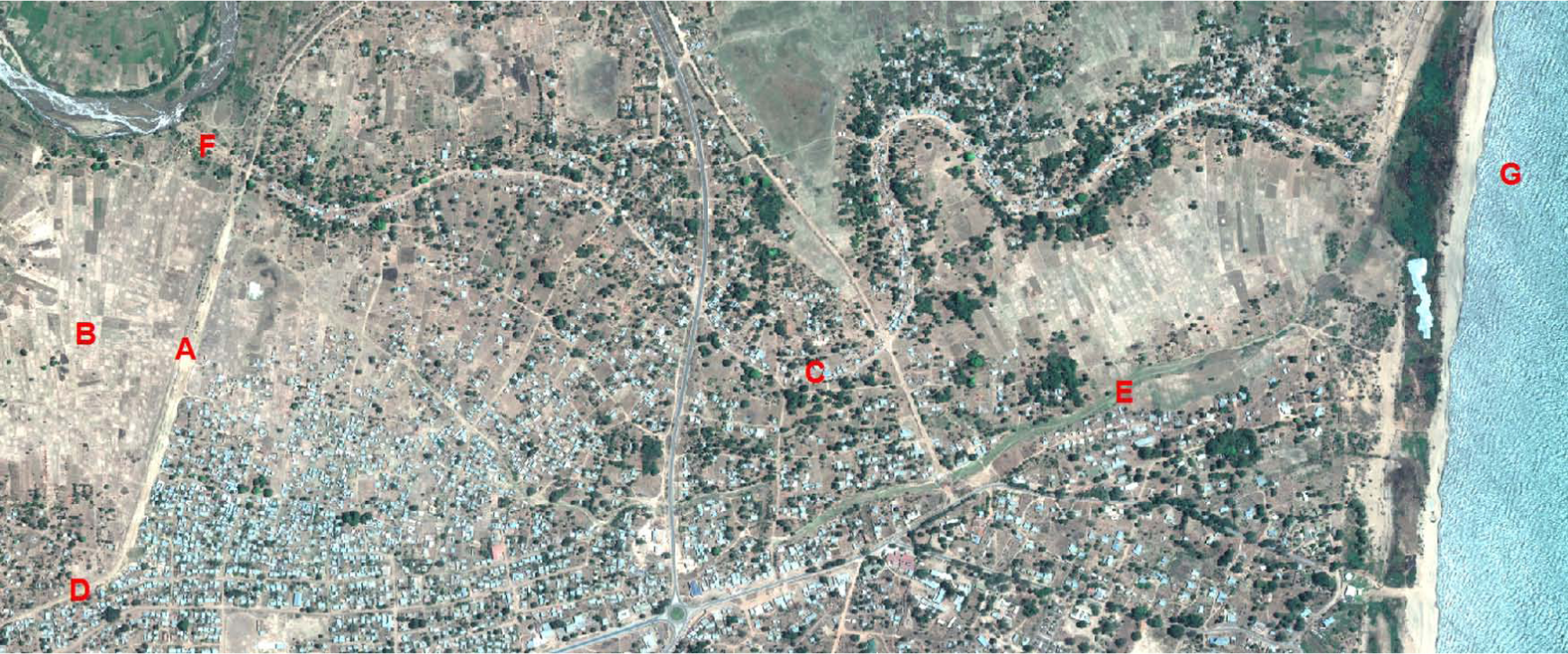
Detail from an image of Karonga showing: (A) the dyke; (B) settlement and rice gardens in flood risk area; (C) artificial flood control channels with houses; (D) point where the dyke lets floodwater into the town; (E) artificial channels to collect pond and stormwater within the town; (F) point where artificial channels relieve pressure off the dyke; (G) Lake Malawi
The revised plan therefore proposed extending the dyke to the highest point westwards and to the lake eastwards, making it eight kilometres long. The plan also proposed an enumeration and voluntary relocation of those hundreds of households living along artificial channels and in the floodwater-holding zone to the extended part of the town where “free” plots would be allocated. For effective defence, the dyke, which was constructed from in situ materials, would be strengthened by widening and raising it, planting perennial crops such as bananas and sugar-cane and constructing concrete walls at specific points. The flood holding zone would then be only used for farming. Regular inspection and maintenance would be carried out. Measures undertaken elsewhere, such as straightening and deepening streams to increase channel capacity and velocity to the lake,(21) were not considered because of the cost. Protection from the lake also called for concrete defences, but this required expert assessment before construction.
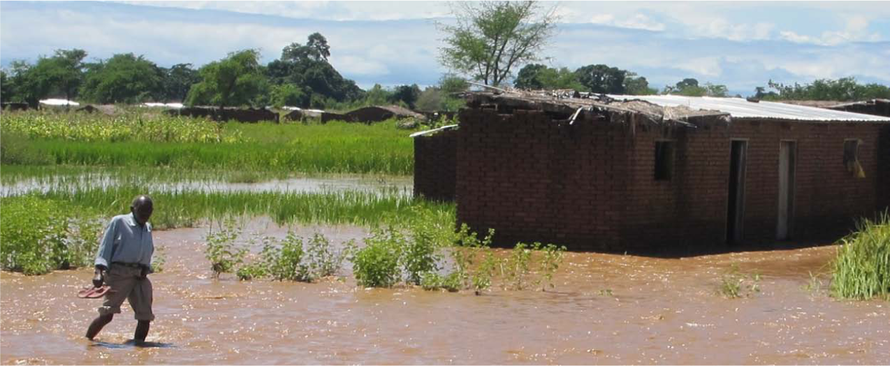
Houses in floodwater-holding zone during flooding
V. Without Local Government, the Plan Fails
The plan proposed two implementation phases, 2012–2017 and 2017–2022, which would coincide with the five-year development planning framework of local governments. The first phase was intended to include detailed designs and the construction of flood control infrastructure such as dykes and lake defences. The second phase included relocation, dredging or the construction of new artificial channels and the finalization of projects. Cross-cutting and management support projects included civic awareness and the procurement of equipment for early warning systems.
Funding for the plan’s implementation was expected through the national funding mechanism, in particular through the Local Development Fund, the National Local Government Finance Committee and locally generated revenues. Stakeholders were encouraged to contribute by picking out implementation packages or choosing activities that they could provide funding for. For example, the Department of Disaster Management Affairs (DoDMA) would fundraise for the dyke, a shift from its traditional disaster response of food distribution.
To facilitate implementation, governance structures were considered essential. Appeals were made for legal representation of the general public on the town planning committee. Urban governance structures that facilitate community participation, such as neighbourhood, ward development and urban executive committees, were also urgently required. Specific to DRR was the proposal that each neighbourhood and ward as well as the urban executive committee be educated and capacitated on hazards, risks, vulnerabilities and resilience. A Karonga town disaster management committee was proposed to streamline the local interface with the national-level institutions. So far, none of the detailed designs have been prepared and no funds have been allocated to implement the urban plan. However, as a response to widespread appeals, the new government of Mrs Joyce Banda, who took over after the death of President Mutharika, has organized national and local elections that are scheduled for 20 May 2014. It is expected that the election of local councillors will help mobilize communities to participate in planning and to demand projects.
Implementation of the plan has faced three challenges, which may turn out to be inseparable. The first relates to funding. Based on an analysis of the literature by the author, a total of well over one billion Kwacha, or in the region of US$ 300 million, may have been spent by government and NGOs after the 2009 earthquakes and 2011 floods to distribute food and tents and on travel.(28) A comparable sum for plan implementation would significantly reduce the vulnerability of Karonga town, at the same time reducing costs related to relief projects. However, in the absence of a local authority to champion the cause, and given the lack of dedicated national funding for risk reduction, not much can be realized. After the planning process, which was funded by UN–Habitat, communities look to the national government’s DoDMA to fundraise for flood prevention infrastructure such as the dyke and artificial channels. In addition, turning to insurance as a risk and recovery tool gets little support; people lack trust in the insurance companies and cannot accept the high premiums. In Ibadan, Nigeria, when strong winds devastated the city centre, some 93 per cent of affected buildings were not insured.(29) In Karonga town, more than 60 per cent lacked insurance for residential property after the 2009 earthquakes, and payments to those who were insured failed to support rebuilding.(30) There is also the major challenge that the plan is not very specific regarding costs or funding for plan implementation. The stakeholders bear the burden for estimating the costs of major planned actions, facilities, infrastructure (new link roads, river or lake defences and artificial channels), relocation and purchase of equipment for early warning and awareness projects, which makes it difficult for potential financiers to make commitments to implementation packages.
The second challenge is the inherent lack of capacity within Karonga and other urban centres in Malawi to regulate urban development, which aggravates the vulnerability of assets, people and whole settlements.(31) The existing national planning standards assume a society divided by class into high-class/low-density, middle-class/medium-density and low-class/high-density housing. But in Karonga, at least 55 per cent of the population live in high-density, overly sub-divided and congested settlements. A lack of tools, a lack of qualified staff and low funding contribute to a failure to monitor the implementation of plans, which in turn contributes to the continued irregular and informal growth of the town and increasing risk. The absence of building regulations, essential for risk reduction, makes the situation worse. The national building regulations were drafted in 1991 but still remain in draft form in 2014. Although the epicentre of two of the 2009 earthquakes was 30–50 kilometres away from Karonga,(32) they caused six deaths, many injuries and serious damage to many buildings and to infrastructure. The most-affected buildings were residential; institutional buildings suffered minor cracks. The Guidelines for Safer House Construction Technical Manual, prepared as a response to the earthquakes, could provide an alternative to regulations; but being externally driven, its recommendations lack institutional and legal sanction. Furthermore, exclusion of the poor from land allocation facilitates the continued construction of low-quality buildings and infrastructure in the town’s risky areas, thereby aggravating vulnerability and potential disaster impacts.(33) Settlers in the floodwater-holding zone and within the artificial channels reject relocation to safer places despite the offer of free plots, in part because their source of livelihood is the rich soil along the otherwise dangerous North Rukuru River and also because of their demands for compensation money, which the government can ill afford. The situation is made worse by a number of factors, including political pressures that allow the properties of political leaders to be built without scrutiny; also low technical and financial capacity(34) and corruption on the part of town rangers(35) who report “no illegal development” after being paid by illegal developers.(36) Authorities are helpless because even the judiciary is unsupportive.(37) The town rangers are poorly trained and lack the most basic skills. To entrust such a cadre of employees with monitoring highly technical work is in itself a contribution to risk. In such situations, as Smith and Petley point out, “… natural disasters simply highlight a deeper crisis.”(38)
The third challenge is the silo planning and implementation strategies. Considering that hazard and disaster issues are cross-cutting, one would expect a multi-sectoral approach to planning and implementation. However, what is observed is that one department operates as the “producer” and another as the “consumer” of plans. During the planning process, none of the Karonga town secretariat staff were involved except in organizing and participating in briefing meetings. All building plans are processed in the city of Mzuzu where a regional office of the Department of Physical Planning is located, with staff from this department only travelling to Karonga for approval meetings. Issues of site verification may not be carried out due to time and funding constraints. Sometimes, several plan “producers” target one “consumer”. Regarding land management, the multiplicity of institutions responsible for managing land on behalf of government results, at times, in conflicting allocation procedures: sites considered risky by planners are allocated to housing or agriculture by other experts. For instance, in a bid to improve food security in the country, the Ministry of Agriculture promotes winter-cropping along rivers; but these are zones that are protected by planners and environmentalists because of their fragile ecosystems. In both cases, the local level bears the burden of monitoring implementation of these contradictory national polices and plans.
Silo planning also occurs because both external and internal departments operate independently of each other, by design or by default. When a proposal was made to establish a Karonga town disaster management committee, little did the planning team know that in 2009, under a Danish-supported project CC–DARE (climate change and development adapting by reducing vulnerability), committees called civil protection committees had been established at the village level(39) to mainstream climate change adaptation in development planning. In fact, although the community vulnerability assessment for the urban planning process unveiled four hazards, a contingency plan prepared in the course of the CC–DARE project, and touted as “a guiding tool for all development initiatives”, had previously been prepared, addressing similar hazards:
“A new contingency plan has been developed that addresses three climate change-related issues, namely floods, droughts and dry spells, and strong winds. The plan also addresses issues of earth tremors and earthquakes …”(40)
Likewise, a disaster task force committee for Karonga, whose role did not differ from that of the CC–DARE project’s civil protection committees, was also established in 2010 under a Church of Central Africa Presbyterian (CCAP) development, the Earthquake Emergency Response project funded through Tear Fund.
This duplication implies resource wastage and may lead to conflicting messages to the communities. More importantly, the fact that the existence of these structures was never mentioned during the planning process, not only calls into question the capacity of the local staff to coordinate urban planning and development, but also points to the seriousness of the gap created by the absence of local councillors. Local councillors would have the moral authority and legitimacy to mobilize and help communities realize their own potential to contribute to the growth of their town. Ideally, local councillors would be keen to monitor projects under implementation as well as any progress rather than simply being a meeting point for external organizations expending donor funds on duplicate initiatives.
VI. Conclusions
The revision of Karonga’s urban plan was meant to lead the way in mainstreaming DRR for various hazards. In addition to promoting community participation, the planning process, especially the community vulnerability assessment tool, was intended to promote awareness and training for both the communities and the planners involved. However, despite the plan’s good intentions, inadequate financing, inherent failures to regulate growth and silo-based strategies, occasioned by the absence of a functional local government, constrain plan implementation. Rapid urbanization creates the urgency to resolve these and other challenges that are impeding progress. Political will and making DRR-mainstreaming conditional for funding support could be the starting point.
Footnotes
1.
2.
3.
McLean, A (2012), Reducing Risks of Future Disasters: Priorities for Decision Makers, Final Project Report, Foresight, Government Office for Science, London, 139 pages.
4.
See reference 1.
5.
Moser, Caroline and Alfredo Stein (2011), “Implementing urban participatory climate change adaptation appraisals: a methodological guideline”, Environment and Urbanization Vol 23, No 2, pages 463–485.
6.
See reference 1.
7.
8.
Wilfred Nawema, the MP from Thyolo, openly expressed his dislike of councillors because of the unnecessary competition with MPs. Many people thought that he was the only one with this extreme view. However, he was only more vocal than others who, while sharing his view, never spoke out. See Lucky Mkandawire, “Malawi MP rejects tri-partite elections bill”, Nyasa Times, 12 November 2012.
9.
For example, Mzuzu City Council was forced by High Court judge Lovemore Chikopa to reverse a decision to sell the property of a defaulter as this was deemed illegal due to the absence of councillors, as required by Local Government Act of 1998, No. 42. See High Court of Malawi, Mzuzu District Registry, Civil Cause No 63 of ![]() between G H Bandawe (trading as Kaka Motel), plaintiff, and Mzuzu City Assembly, first defendant and Kesale Auctioneers and Estate Agents, second defendant.
between G H Bandawe (trading as Kaka Motel), plaintiff, and Mzuzu City Assembly, first defendant and Kesale Auctioneers and Estate Agents, second defendant.
10.
Adelekan, Ibidun O (2012), “Vulnerability to wind hazards in the traditional city of Ibadan, Nigeria”, Environment and Urbanization Vol 24, No 2, pages 597–618.
13.
Runduka, R, M A R Phiri, C Kambani and C Boyer (2010), Malawi Disaster Risk Reduction and Climate Adaptation, Research for CordAid, Lilongwe.
14.
15.
16.
Biggs, J, E Nissen, T Craig, J Jackson and D P Robinson (2010), “Breaking up the hanging wall of a rift border fault: the 2009 Karonga earthquakes, Malawi”, Geophysical Research Letters Vol 37, L11305, pages 1–13.
17.
See reference 16.
18.
19.
Satterthwaite, David (2011), “Why is community action needed for disaster risk reduction and climate change adaptation?”, Environment and Urbanization Vol 23, No 2, pages 339–349.
20.
For example, when houses were damaged in Lilongwe in January 2013, the first reaction was to provide food relief. On a monthly basis, the DoDMA jointly with the UN World Food Programme distributed food to households under the MVAC programme worth millions of Kwacha; see Daily Times, 15 November 2012.
21.
Randolph, J (2004), Environmental Land Use Planning and Management, Island Press, Washington DC, 664 pages.
22.
Smith, K and D N Petley (2009), Environmental Hazards: Assessing Risk and Reducing Disaster, London, Routledge, page 85.
24.
Steiner, F R and K Butler (2007), Planning and Urban Design Standards, John Wiley & Sons, New Jersey, page 94.
25.
Redwood, M (editor) (2009), Agriculture in Urban Planning: Generating Livelihoods and Food Security, Earthscan, London, 272 pages.
26.
See Pelling, Mark (2011), “Urban governance and disaster risk reduction in the Caribbean: the experience of Oxfam GB”, Environment and Urbanization Vol 23, No 2, pages 383–400.
27.
Pizarro, R (2009), “Urban form and climate change – towards appropriate development patterns to mitigate and adapt to global warming”, in S Davoudi, J Crawford and A Mehmood (editors), Planning for Climate Change: Strategies for Mitigation and Adaptation for Spatial Planners, Earthscan, London, pages 33–45.
28.
DfiD, for example, had spent UK£ 750,000, or K 447 million, to build 100 houses and sensitize communities as part of the earthquake recovery; see The Nation, 1 February 2013.
29.
See reference 10.
30.
Tembo, P M (2010), “Factors hindering residential property insurance in Karonga township”, Research Report for BSc Degree in Land Management, Mzuzu University.
31.
See reference 1.
32.
See reference 16.
33.
For example, four houses were damaged during an otherwise normal heavy downpour in Ndirande squatter township in the city of Blantyre. The houses had been constructed close to or over large water drainages; see The Nation, 19 December 2012.
34.
This observation questions claims of “improved capacity for district council staff to mainstream climate change adaptation in planning”, more so when the indicator is only a “training workshop report”; see ![]() , Mainstreaming Climate Change Adaptation into District Development Planning System in Karonga District Assembly, Project Report, CC–DARE, UNDP/UNEP, 16 pages.
, Mainstreaming Climate Change Adaptation into District Development Planning System in Karonga District Assembly, Project Report, CC–DARE, UNDP/UNEP, 16 pages.
35.
Town rangers are government or council employees who monitor adherence to land use and building plans.
36.
As reported in the Daily Times, 9 November 2012, a new private secondary school was the subject of land conflict with a government hospital despite formal land allocation and planning approvals.
37.
In Zomba town, settlers under a high voltage power line whose poles needed replacing refused to relocate. The court issued an injunction in their favour, making both their proposed relocation and repair of the poles impossible, and in the process making them vulnerable to electrocution and fires.
38.
See reference 22, page 8.
39.
The reporting levels are from bottom to top: village civil protection committees, area civil protection committees, district civil protection committees, district executive committee, DoDMA, national disaster preparedness relief and relief technical committee, national disaster and relief committee and finally the cabinet. Within this structure, towns and cities are assumed not to experience any disasters.