
Abstract
This paper describes how a settlement profile, mapping and enumeration of Magada, an informal settlement in the town of Epworth just outside Harare, provided the basis for an upgrading programme. This was both in terms of the needed information and in terms of agreement between the residents and their community organizations and local and national government. The local government’s agreement to support in situ upgrading was the first of its kind in Zimbabwe and it is the first settlement plan to include meaningful participation by residents in articulating their own development priorities and in influencing the design. The work to map and number each plot was undertaken by teams that included residents, supported by members of the Zimbabwe Homeless People’s Federation and its support NGO Dialogue on Shelter Trust, along with planning students. This was supported by high resolution satellite images and a GIS process was developed drawing in data from enumerations covering each household. A concept plan was developed and presented to residents and the local government to allow feedback. A survey of buildings showed where there were clusters of commercial activities and allowed mixed land uses to be accommodated in the upgrading plan. Guidelines were developed to show where the proposals contravened existing official standards and to justify what was proposed. The paper ends with a consideration of what still needs to be accomplished – including agreement on the re-alignment of plots, the means for transferring tenure and how to finance proposals. It is hoped that this initiative will lead to a protocol for in situ upgrading that can be used to inform the upgrading process in other cities in Zimbabwe.

I. Introduction
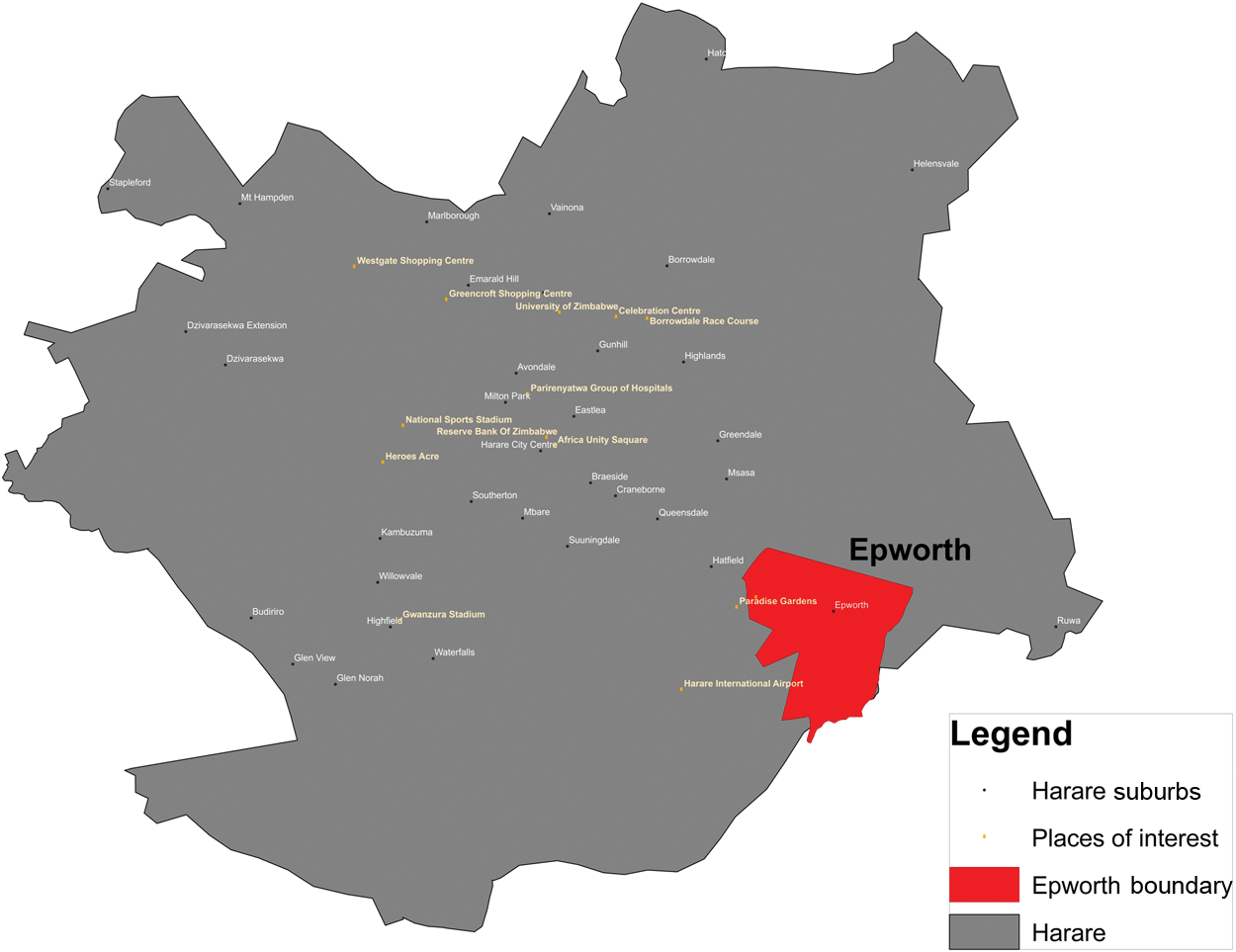
Epworth is a town situated 10 kilometres outside Harare, the capital city of Zimbabwe, and has an estimated population of about 130,000 (Figure 1). The 2001 national census put the population of Epworth at 114,067, accounting for 2.8 per cent of Zimbabwe’s urban population at the time. The Methodist Church established Epworth as a mission station in the late nineteenth century on land where a local community was already resident. Rather than evict these families, as was the norm then, the church “allocated” each family up to an acre of land; however, this was more a permission to stay than a legal entitlement to the land. Four villages − Makomo, Zinyengere, Chiremba and Chinamano – developed, and over the years became known as the original villages.
Map of Greater Harare
In the 1970s, with the intensification in rural areas of the war of liberation against the colonial Rhodesian government, there was increased in-migration to Epworth. The new immigrants settled in the areas contiguous to the original four settlements and these became known as extensions to each of the four villages.
At Independence in 1980, and with the abolition of influx control regulations, the in-migration continued. The Methodist Church resolved to transfer the settled land to central government as they felt unable at this point to contain the growth of Epworth. The government proceeded to appoint a local board, which included resident commissioners, to administer the affairs of Epworth. This included upgrading, to modernize it and make it into an “urban” settlement. The vision then was that Epworth needed tarred roads, piped water and sewers and electricity, like other urban settlements. This process would also involve the regularization of tenure. However, a development freeze was instituted in 1982, meaning that any development within Epworth after that date would have to be approved by the local board and would have to adhere to Epworth’s formal plans. This included any new settlement in the extension areas as well as any new construction on existing and recognized plots. A quasi-government agency, the Urban Development Corporation, was tasked with the physical planning of the settlements in question, with supervision from the Department of Physical Planning within the Ministry of Local Government.
The effort to control unauthorized development in Epworth failed. On the one hand, the increasing urbanization in Harare continued to have spillover effects on Epworth. Its proximity to Harare and the availability of cheap housing meant that new immigrants to Harare continued to settle in Epworth. The “original settlers”, who believed they had greater rights to the Epworth land, began selling off plots to the new immigrants, creating further expansion of the settled land. In 1991, the government sought to effect control over this trend and evicted nearly 1,000 families to Porta Farm, 40 kilometres outside Harare. Despite this, Epworth continued to grow. The growth was manifested in increased densities in the original villages as well as the development of new settlements in the area contiguous to both the original and extension villages. Of particular significance was the growth in the Magada settlement.(1) Between 1991 and 2005, the local board made a series of attempts to evict the settlers in Magada but these were never successful, as more people continued to move in. By 2010, more than 6,500 families had settled in this one area of Epworth alone.
Poorly resourced and lacking in capacity, the Epworth Local Board continued to rely heavily on central government for financial and technical assistance. The quasi-government agency, Urban Development Corporation, which had been tasked with planning the upgrading, began to face problems and the plans were delayed significantly. There was no experience within this agency of planning within already settled areas and there was no real consultation with the community. The families with larger plots felt that they could not consent to sub-divisions, which meant that the proposed road and sewer network, as well as any other proposed service delivery, would be very costly per household. The result was that even with a grant from central government, the Epworth Local Board managed to extend water and a primary road network to less than 10 per cent of the Epworth Local Board area.
Over the last 10 years, Epworth has continued to grow. Land from the families that had been evicted in 1991 was re-settled. As the Zimbabwe Homeless People’s Federation established itself in the former holding camps that were set up to house evicted families in the late 1990s, former Epworth residents in the holding camps of Porta Farm and Dzivarasekwa Extension returned to Epworth and initiated the first federation savings schemes. Over the years, the initial groups in Epworth grew and began to mobilize others, resulting in 12 savings schemes with a membership of about 400 households. The savings schemes started a dialogue with the Epworth Local Board, and in 2007 there was a joint exchange to Kenya, accompanied by the secretary of the local board. Once there, they were able to establish the significance of information collection in initiating dialogue between local authorities and communities and how this then enabled both parties to plan together.
II. The Profiling and Enumeration Phase
The Epworth Local Board was very realistic about its own capacity to deliver on the development priorities of Epworth. During this period in Zimbabwe’s history, central government’s capacity to continue to support the local board was severely challenged, owing on the one hand to the prolonged economic crisis and on the other to the board’s own incapacity to collect revenue from the more than 30,000 families resident in Epworth. Because people lacked formal tenure, and were hence outside of the local authority’s system, there was very little the local authority could do to collect the revenue needed to deliver services. What the local board was convinced of, however, was the ineffectiveness of its past policy of evicting families who had settled on land after the 1982 development freeze. As a testimony to this position, despite the 2005 countrywide Operation Murambatsvina that forcibly cleared informal settlements, the local authority had not evicted the settlers in the Magada settlement. The exchange to Kenya was therefore well timed in that it fed into a conversation that was already taking place at the local authority level. However, the local board still had questions on how, even with the necessary political will, upgrading plans could be resourced.
Dialogue on Shelter Trust, a local Zimbabwean NGO, works in alliance with the Zimbabwe Homeless People’s Federation (a network of community organizations) to address issues of land tenure and service delivery in poor urban neighbourhoods in Zimbabwean cities and towns. The Zimbabwe federation has a membership of more than 47,000 families, organized in 66 centres that range from small service centres to cities and towns. The alliance is also an affiliate of Shack/Slum Dwellers International.(2)
In 2007, after a successful exchange with the Kenyan federation (Muungano), the alliance approached the local board with a suggestion for developing an upgrading protocol that would not only build on the initial attempts to upgrade parts of Epworth but also look realistically, first, at the development challenges that Epworth currently faced. A first step in this process therefore was to gain a holistic understanding of Epworth as a settlement, followed by a prioritization of what sections of the settlement to focus on first. A whole profile of Epworth would enable the emerging partnership of Dialogue on Shelter Trust, the Zimbabwe Homeless People’s Federation and Epworth Local Board to create a consensus on the critical issues, and also decide on which locality to focus on first.
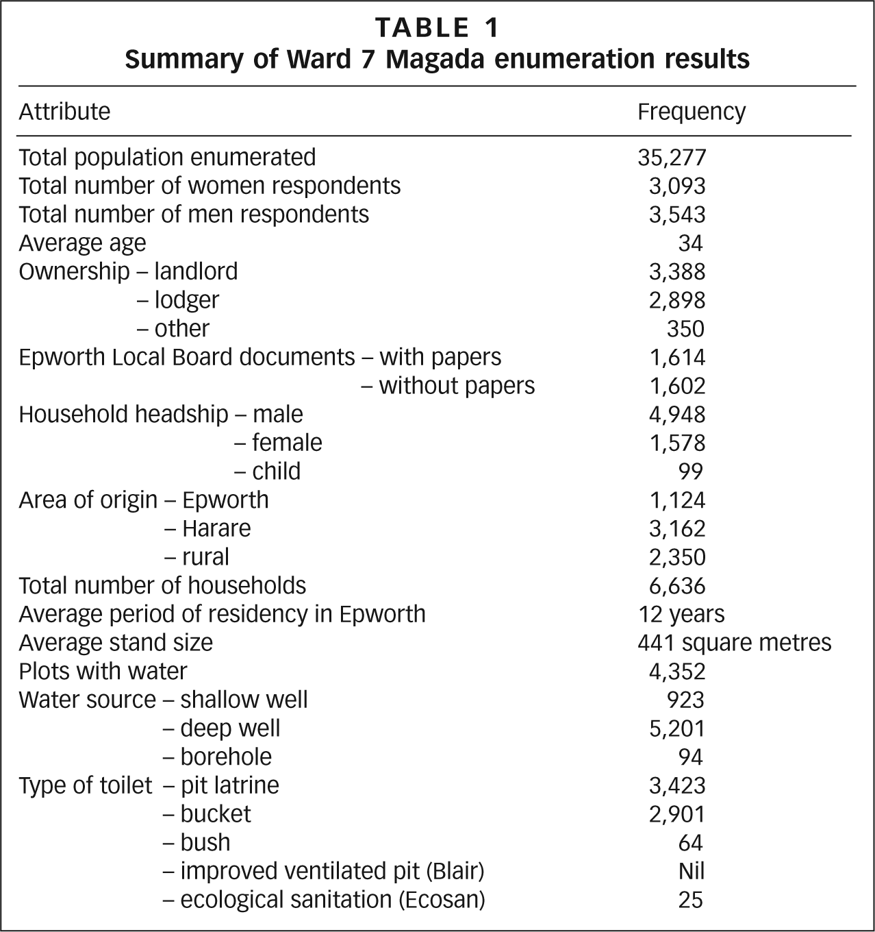
A profile of Epworth was completed in 2009 and a document was produced.(3) Through this process, alliances were build with the Epworth community beyond the federation membership. A decision was made to start the process of upgrading in the Magada area of Ward 7 first, as it was not only the largest of all the settlements within Epworth but also the most informal. Residents of Magada had lived with the threat of eviction for a very long time, and beginning the process of looking at tenure more seriously would make a huge difference to the settlement. In addition, because most of the settlers were “illegal”, there was a more cohesive voice on the need to secure tenure and what form this might take. By contrast, for example, in the original settlements, the original settlers felt more entitled to the land. The size of the Ward 7 Magada settlement also meant that the proposed upgrading could be done to scale and the impact would also be more significant. In addition, on their own initiative and with leadership from their councillors, the Magada community had elected a very motivated development committee that had overseen the development of a “strategic plan” that prioritized their needs as a community. Central to these priorities was security of tenure for all families resident in the Magada settlement. Using community contributions, they had engaged a planner to start the process of developing a layout, which they planned to present to the local board for approval. However, resources were always going to be a challenge. Another issue that came to the fore during the initial stages was disagreement on the estimated number of people living in the Magada area. The development committee had estimated that more than 11,000 families were resident in Ward 7; however, estimates during the profiling phase put the figure at just over 6,000 families. There was therefore a need to reconcile these figures as they would have a direct bearing on subsequent upgrading proposals. In 2010, a detailed enumeration exercise was undertaken to establish accurate figures, as well as to begin the process of mapping the settlement in preparation for developing a layout (Table 1). In order to ensure wider buy-in for the process, a number of critical stakeholders were invited to participate and formally partner in this exercise.
Summary of Ward 7 Magada enumeration results
The Ministry of National Housing and Social Amenities is responsible for coming up with a national housing policy, and a deeper understanding of the Epworth upgrading exercise would enable the ministry to have a better appreciation of the policy alternatives to evictions. Since Operation Murambatsvina in 2005, there has not been a formal position on evictions, although there are indications that both central and local government have moved on from a de facto policy that favoured these. However, there has been no change in policy nor have alternatives been tried out. The ministry agreed to participate as a partner and provided personnel for the enumeration process, who joined in with the federation enumeration teams and Epworth residents.
The wider Shack/Slum Dwellers International community supported the enumeration with technical skills, especially around mapping, as well as sequencing vital exchange support to the process. Members of the Kenyan federation and staff from their support NGO trained the Zimbabweans in the use of GIS mapping systems, as well as generating maps for use in the actual physical mapping of Ward 7.
The Epworth Local Board, as the local planning authority, sanctioned the process and also participated in learning exchanges and in the actual process of gathering data. They provided the “formal” seal of approval required for a process such as this and thus enabled easier buy-in by both the community and local politicians.
The local politicians (in the form of the local Ward 7 councillor as well as councillors from the other six wards) approved the process, while also providing the necessary political leadership. The Epworth federation savings schemes took a leadership role in organizing the mapping and enumeration process. They provided the logistical support and also ensured that the whole community was motivated to participate.
III. Community Mapping and the Use of Gis Technology
Geographic Information Systems (GIS) have revolutionized the usability of information for planning, internationally. Within the Shack/Slum Dwellers International network there is a conscious effort to develop skills sets that will enable communities to accurately link information collected during household level enumerations with mapping. GIS has created the possibility of linking social data with spatial data.
In preparation for the mapping exercise in Epworth Ward 7, the alliance of Dialogue on Shelter Trust and the federation purchased a satellite image that covered Epworth (Figure 2). In considering what image would be useful, technical considerations such as the resolution as well as the age of the image were taken into account. Because of the level of detail required to provide accurate mapping information for planning and regularization, a minimum resolution of 0.5 metres was required. In addition, it was necessary to ensure that as recent an image as possible was used. Informal settlements are very dynamic and change all the time, so a recent image would enable the mapping team to accurately map out what is on the ground.
Satellite image of Epworth and Ward 7
An added consideration was the transferability of technical skills to community members with little or no education. There was initial concern that by going high tech, the process would become exclusionary. A strategy to involve recent planning and surveying graduates from the University of Zimbabwe resulted in the recruitment of a vanguard team that already had computing knowledge. A team from Kenya then worked with this team on the initial mapping exercise, involving new members of the Zimbabwean federation as they went along. A special training exercise with a return team from Kenya was later organized to develop these skills, but also to expose to GIS other federations that were SDI affiliates. Over the last year, this survey team, with support from a recent land surveying graduate employed by Dialogue on Shelter Trust, has continued to train new members but has also been developing a strategy around the mapping requirements for other informal settlements in the country. By splitting the purely computer-linked processes and the mapping verification processes it has been possible to ensure wider participation in the mapping process. A team with GIS knowledge can then produce mapping products that can be used and interpreted by community people without this specialist knowledge. However, the fact that the team included both university graduates and trained community members has helped ensure that the process is not removed from the community.
One challenge with GIS that has yet to be resolved in Zimbabwe relates to the cost of acquiring satellite images. None are produced locally and the process is very new in Zimbabwe. This has meant that images have to be sourced internationally, using middlemen who often charge exorbitant prices. There is a proposal to donate the Epworth image to the local board, but there are capacity issues with this as the local board does not have the necessary equipment to use this information. In addition, it is a static image that shows the settlement at a given date; any changes would require a new image.
IV. The Mapping Process
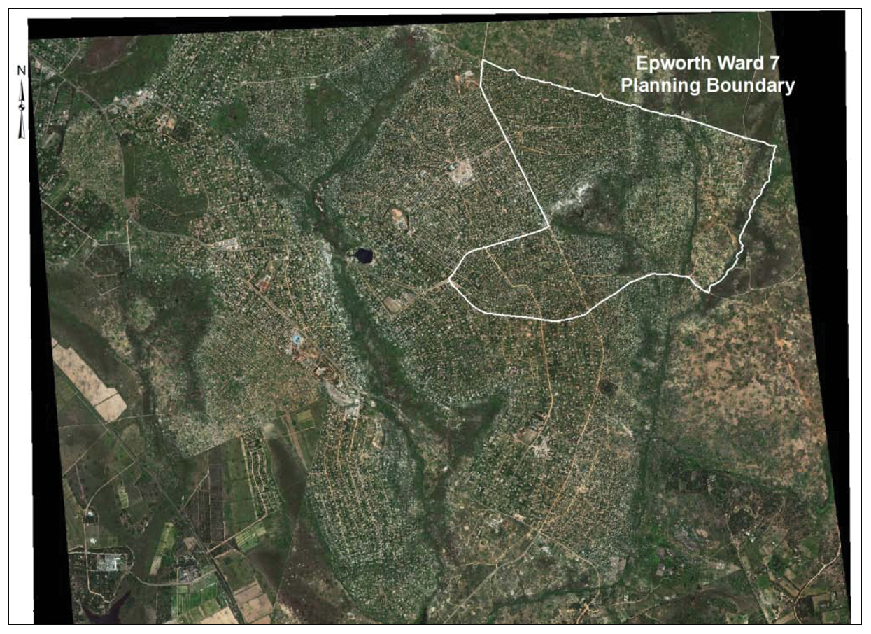
A team comprising community members from Ward 7, team leaders from the federation’s technical team as well as a planner from Dialogue on Shelter Trust and students from the Department of Planning and Survey at the University of Zimbabwe was assembled. The students were chosen from the third year set, which had enough theory and practice with GIS to be able to add value to the process. The team received training from a visiting group from the Kenyan federation. This team would be further sub-divided into smaller groups of 4−5 members, who would be tasked with the mapping of a specific section. The mapping of these sections of Ward 7 would be in very high resolution, so that detail such as hedge boundaries wells or toilets could be picked up. Armed with tape measures and paint, team members physically verified the boundaries of each plot as shown on the map and assigned each with a number. Where boundaries were not visible, they would have discussions with neighbours to ascertain where these were and then mark them on the maps. Because of its informality, the process of verifying boundaries would often lead to conflicts, and a process of resolution would be initiated to ensure that whatever was captured on the map would be acceptable to the residents. The team also marked out man-made and physical features such as prominent rock outcrops, toilets and wells. Once the field maps had been generated, another team digitized the information by superimposing data collected in the field back onto the satellite image (Figure 3).
Digitized features of Ward 7
The process of digitizing the map took time and this caused impatience within the community, which had been very anxious to produce a layout plan for their settlement. The perception of residents in Ward 7 was that once they had a regularized layout plan they would have secured their tenure rights.
A meeting of the Ward 7 development committee, the Epworth Local Board, the federation and Dialogue on Shelter Trust was convened to discuss the way forward, given the information that had been collected. Two central government departments, the Department of Physical Planning and the Research Department within the Ministry of National Housing, were also invited to participate. The enumeration results had provided valuable information on the array and scale of needs within Epworth, identifying improved sanitation, water, schools and functional road access as major development priorities All stakeholders now had a clear sense of numbers in terms of the households resident in Ward 7 as well as other demographic information necessary for planning, including the number of school age children. The mapping exercise had produced detailed maps with enough information to enable the start of the layout planning process.
The meeting had the following agenda:
validate and share summary findings of the Ward 7 profiling and enumeration process;
present preliminary results of satellite mapping for Epworth and the plot boundary “marking” exercise for Ward 7;
develop an upgrading guide;
develop stakeholder consensus necessary to come up with a plan of action for the next steps; and
allow sharing of knowledge on upgrading strategies, especially with other government departments.
The next steps were agreed at the meeting, starting with the development of a layout planning process that would combine technical expertise and community participation. It was agreed that a planning consultant would be hired whose brief would be to interpret community priorities in the process. Four recent planning graduates were also added to the team. The planning consultant and graduates would be joined by the Epworth Local Board engineer, Ward 7’s development committee, the planning/survey students, the federation’s technical team and Dialogue on Shelter Trust to make up a steering committee to spearhead the production of the layout plan. It was also agreed that the Department of Physical Planning within the Ministry of Local Government and Urban Development would be asked to second technical staff to participate in the planning process, with the intention that by the time the plan was to be presented for approval, the department’s input would already be integrated.
The main objectives of the upgrading process were identified as:
Regularization:
■security of tenure; ■land sub-division; ■stand numbering; ■formulation of context-based development conditions.
In situ upgrading:
■road layout design; ■water and sanitation upgrading design; ■identification of suitable public sites; ■facilities (schools, shopping centres, places of public worship).
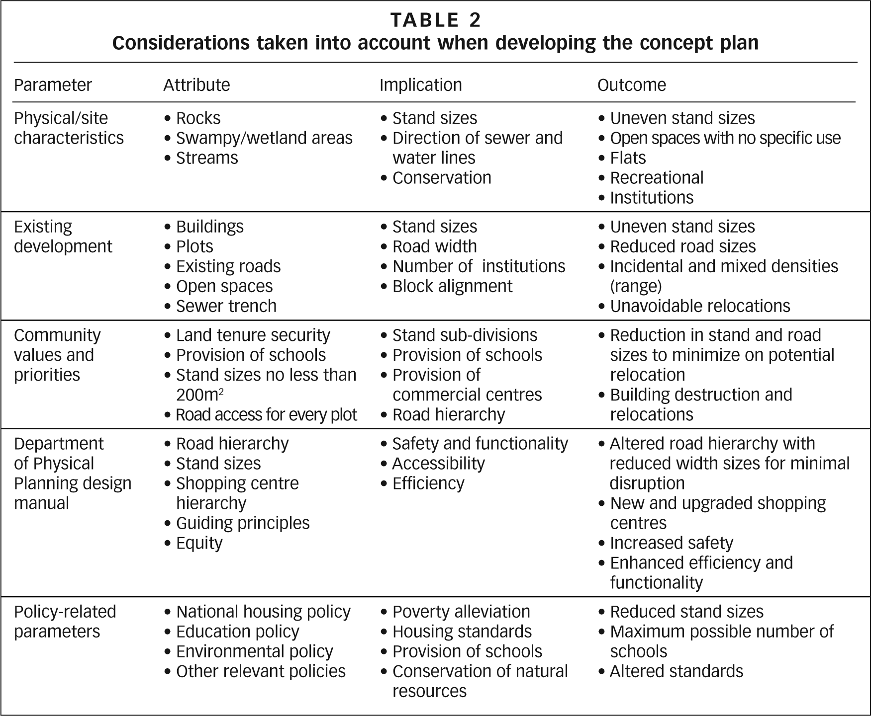
The first stage was the production of a concept plan (Figure 4) that looked at the existing informal road network and tried to stay true to this. The plan also included proposals for the provision of social amenities such as schools and hospitals, as well as places for business and other land uses that are common in settled areas. Again, the concept sought to stay true to what was already on the ground but also looked at what the expected provision for an area such as Ward 7 should be. At this point, there was already a consensus within the team that it would not be possible to stick to the Department of Physical Planning’s design guidelines set for planning new (greenfield) sites, and that this process would be used to negotiate new design parameters that would be a compromise between community priorities and the existing guidelines set by the Department of Physical Planning. Table 2 shows what was taken into account in coming up with the concept plan and the implications for the detailed layout plan, as well as the possible outcome envisaged.
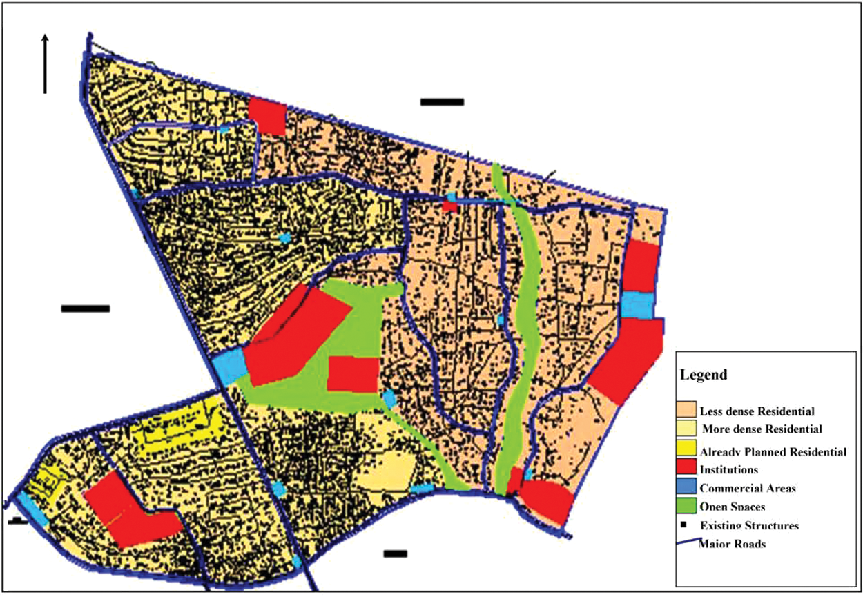
Epworth Ward 7 concept plan
Considerations taken into account when developing the concept plan
Once the concept plan had been completed, it was presented to the wider Epworth community. Its visual and colorful nature allowed the community to link their proposals spatially and see how the various land uses would relate to each other. The satellite image enabled the community members to see the whole settlement in context, linking all the proposed land uses as well as the road network. This visual element to the planning process enhanced the community’s capacity to understand the proposals and to link these to their own development priorities. A case in point was the number of schools that had been suggested. The school proposed in the southwest of the planning area was perceived to be located in an area that was very densely populated. This would entail significant relocation of families to accommodate the school, as the required space was quite large. The minimum size of a primary school as per existing government guidelines needs 3.5 hectares – with the potential to relocate a minimum of 160 families. A way around this was to look at Ward 7 as not existing in isolation but, rather, to integrate the upgrading of Ward 7 by linking it to existing development in the neighbouring wards. So the proposal instead was higher density housing in the form of clustered housing.
An additional point raised during the feedback was that the detailed phase of the planning process would benefit from a better understanding of the key physical aspects of the settlement. So another survey was carried out to add to the mapping and boundary demarcation that had already been done. This was carried out by four teams, with support from recent planning graduates, and looked at the following additional key aspects through a physical survey as well as analysis on GIS.
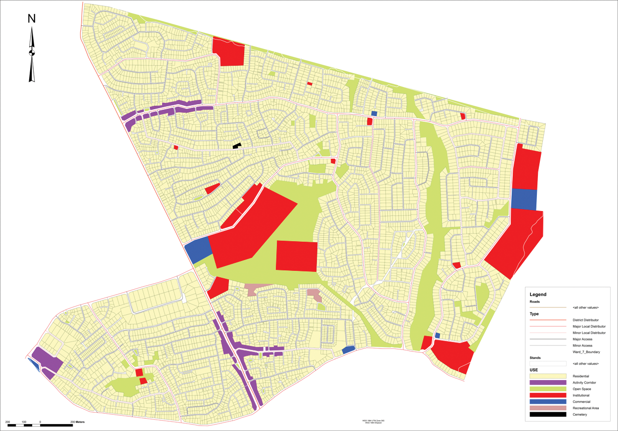
Current land use and use of buildings (Figure 5)
While it was expected that a majority of the buildings would be used for residential purposes, it was also important to identify all the current uses. This would then enable the planning team to incorporate these uses into the proposals presented to the Department of Physical Planning for approval, ensuring that, for example, mixed uses would be permissible. From the map it would be easy to zone in on a particular site and propose a particular land use because of its predominance within that neighbourhood. Activity corridors were proposed in certain neighbourhoods where commercial activity was predominant. Mixed land uses such as industrial and residential were also proposed, to reflect the existence of home industries in certain localities.
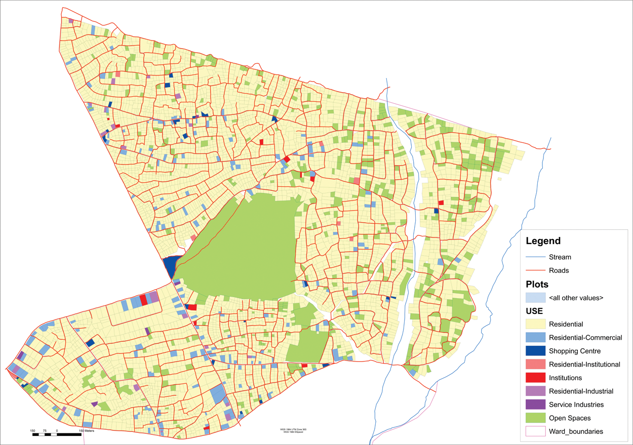
Epworth Ward 7: Current land use and use of buildings
The condition of buildings (Figure 6)
The survey ranked buildings according to their physical condition. By mapping the relative condition of each building, the team would be able to locate services and minimize the costs of relocation. There would therefore be a bias towards maintaining buildings in better condition. The idea was that in situations where it would be necessary to demolish a structure to make way, say, for a road, then the location of such as road would be influenced by the minimum cost of relocating whatever was already there. Mapping this and showing it spatially would enable the team to make a decision in situations where it was inevitable that a building had be demolished and relocated elsewhere in the settlement. While the default position was that the layout proposal should as far as possible minimize relocation, the assumption was that it would cost less to relocate a relatively poorly constructed building.
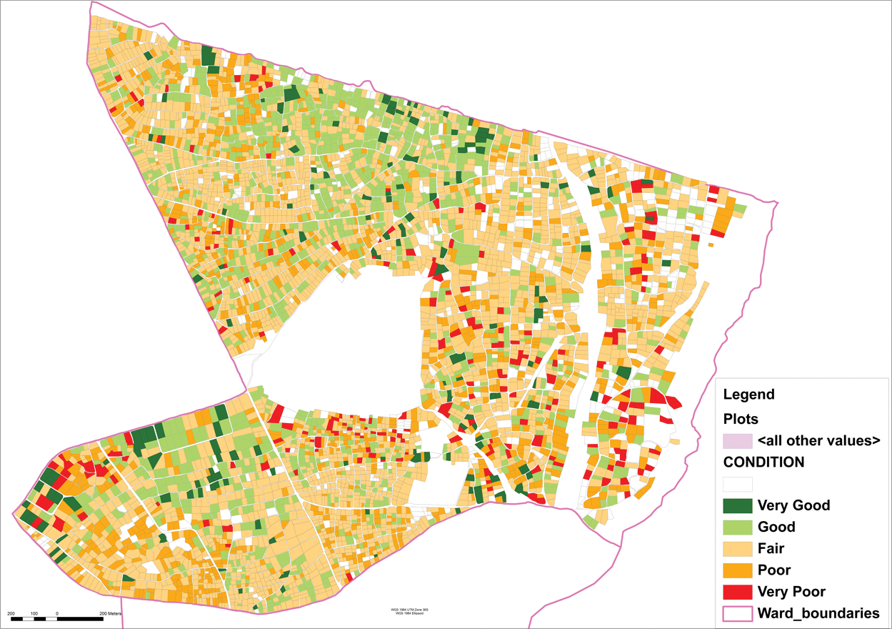
Epworth Ward 7: condition of buildings
The orientation of buildings (Figure 7)
This looked at the direction that buildings faced, and would assist in figuring out the position of roads and the potential direction of services such as water and sewer lines.
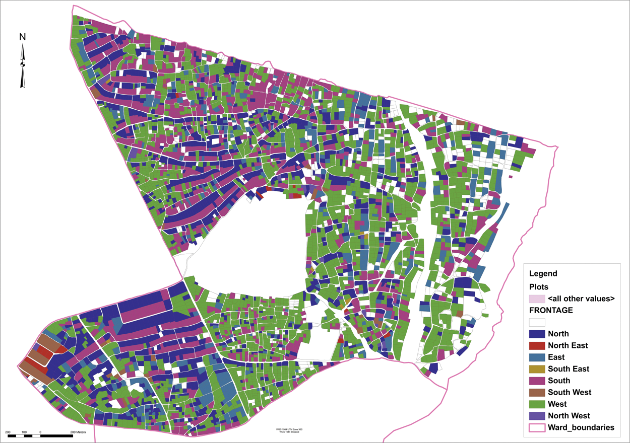
Epworth Ward 7: orientation of buildings
Densities (Figure 8)
This looked at the existing densities within the settlement. The idea was to maintain existing densities within a reasonable range. If families could generally end up with parcels of land that were not significantly dissimilar to what they were used to, this would minimize resistance to any proposal. While the political leadership within Ward 7 is convinced that there is a general consensus that some concessions will have to be made in regularization, it would make it easier if the process minimized the costs to families.
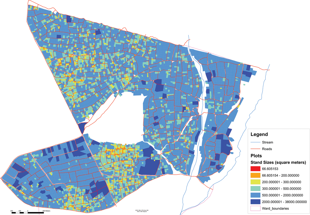
Epworth Ward 7: stand sizes
It was also agreed that Ward 7 would be divided into manageable sections, and the graduate planners would then facilitate the processes of community planning, whereby in each neighbourhood a community planning team would take the lead in designing the road network and would present this to the wider neighbourhood for feedback and approval. This process would begin to anticipate the re-alignments that might eventually be required, also who might potentially be asked to move or shift to make way for a road. A collection of these community maps was eventually combined and formalized to produce the first draft of the layout.
Figures 9A and 9B show a section of a community-generated plan and the final layout section.
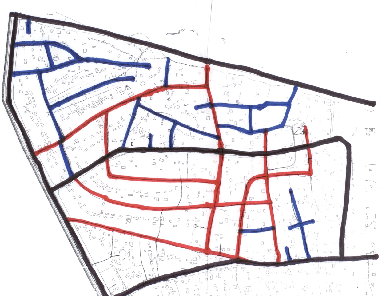
Community-generated layout plan
Final regularized layout plan with community participation
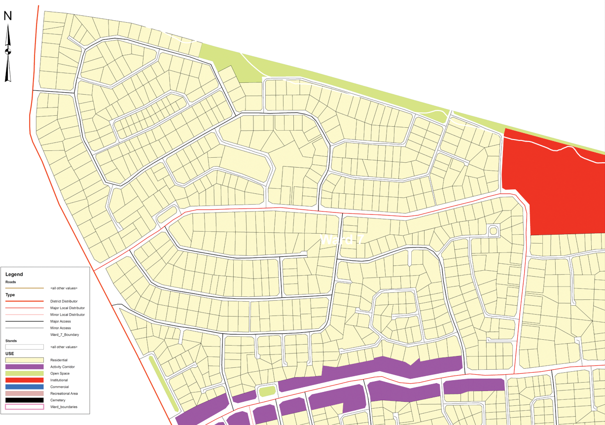
The first complete draft was then presented to the planning task team, Epworth Local Board and the Department of Physical Planning for feedback and comments (Figure 10). There were minimal changes proposed to the draft and this, with minor changes, was presented to the Department of Physical Planning for approval in November 2011.
Layout plan 16
Table 3 shows the variations between the layout proposals and existing Department of Physical Planning standards, and the justification for these.
Planning standards reworked
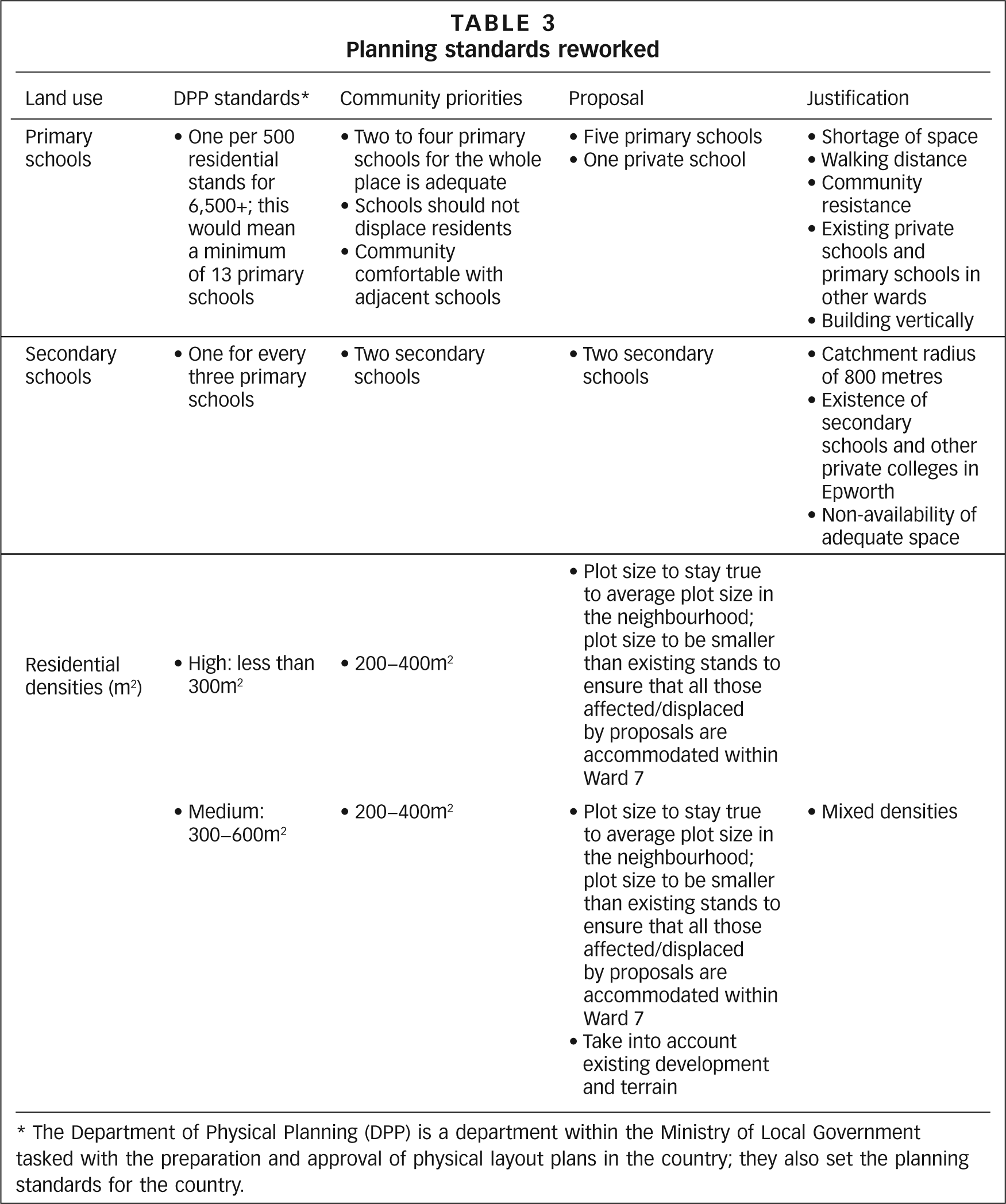
The Department of Physical Planning (DPP) is a department within the Ministry of Local Government tasked with the preparation and approval of physical layout plans in the country; they also set the planning standards for the country.
V. Emerging Lessons
The process in Epworth so far has largely been one of developing proposals for the in situ upgrade. The Epworth Local Board’s council resolution to upgrade in situ is very progressive and is a first of its kind in Zimbabwe. The local political leadership, in rallying the community around this process, has shown strong leadership. The increased level of security for the 6,500+ families within Ward 7 has allowed them to begin addressing their development priorities, starting with sanitation. Over the period that this planning process has been taking place, the community has been organizing to upgrade their sanitation, with 50 initial ecological sanitation toilets planned as a first phase.
By largely leading the process, there is an added responsibility fostered on the alliance of Dialogue on Shelter Trust and the Zimbabwe Homeless People’s Federation to manage this process further. A combination of factors has led local authorities in Zimbabwe to abrogate what traditionally should be their role – namely making land available for housing development and delivering services to the urban poor within cities. For the alliance, the trick has been to balance the process of innovation and demonstration with balanced expectations and realistic role allocation between the state, NGO and community. These roles can evolve over time. The expectation of the alliance is that the state will be more visible in terms of the role it takes, as the scale of the needed upgrading can only be achieved with real commitment from the state to tackle these issues.
In some respects the planning phase has been the easy part. The partners that have been involved are conscious that the layout planning phase is just the beginning of the upgrading process. There is still the need to develop a process of negotiation at the community level as the re-alignment of the plots takes place. The level of awareness within the community regarding the upgrading proposals, as well as the level of participation, will ideally make this process a lot easier. The proposed layout, while likely to displace and relocate about 250 families, managed to ensure, based on the number of enumerated households, that each household would have a plot.
The proposals within the layout will require financial resources to be actualized. There is no indication at the moment that the Epworth Local Board has started discussions on how some of the proposals will be financed. A model is being developed around the construction of the ecological sanitation toilets, and is based on the premise that investment by the community with support from the federation’s Gungano Urban Poor Fund will mobilize the necessary resources. However, there is a need for a conversation within the Epworth Local Board on how the rest of the development will be financed. Furthermore, there is a plan to replicate the process in Ward 4, and all these activities will also have to be financed. The plan that has been completed will be useful as a basis for guiding the various efforts of state and non-state actors involved in Epworth.
The information collected during this process will be migrated to Epworth Local Board. It is anticipated that the local authority would then create a database that could be used to complete the process of conferring tenure rights to the residents of Ward 7. There are still unresolved issues regarding access to the information by a wider audience. In requesting the Epworth Local Board to host this information, the assumption had been that the local authority would be best placed to act as a central reference point. In addition, as the enumeration information was collected more than a year ago, there will also be the need to carry out an updating exercise as well as re-verification.
In many ways, the Epworth upgrading is the first of its kind in Zimbabwe. It is the first to use new spatial technology to plan for the upgrading of an informal settlement, and this upgrading will enable more than 6,500 households who have lived with insecure tenure to secure tenure rights. It is also the first to include real and meaningful participation by the residents in articulating their own development priorities, as well as having a significant input into the design of their settlement. The alliance of Dialogue on Shelter Trust and the Zimbabwe Homeless People’s Federation is keen to develop with the Epworth Local Board and other stakeholders such as the Department of Physical Planning a protocol for in situ upgrading that can be used to inform other upgrading processes in other cities in Zimbabwe.
Footnotes
1.
“Magada” is a Shona term coined by the new settlers in Epworth and, loosely translated, can be taken to mean “As we please” – a reference to the unplanned and unauthorized nature of their settlement. So while within Epworth the term “Magada” is used for all unauthorized housing, as all of the housing in Ward 7 is unauthorized the latter is often referred to as Magada, even though this term can also be used for unauthorized housing in other wards of Epworth. In this paper, Magada and Ward 7 are used interchangeably to refer to the area covered in the enumeration and mapping discussed here and whose boundaries are shown in ![]() .
.
2.
For more information on the work of Dialogue on Shelter Trust please also refer to Chitekwe, Beth and Diana Mitlin (2001), “The urban poor under threat and in struggle: options for urban development in Zimbabwe, 1995−2000”, Environment and Urbanization Vol 13, No 2, October, pages 85–101; also Chitekwe-Biti, Beth (2009), “Struggles for urban land by the Zimbabwe Homeless People’s Federation”, Environment and Urbanization Vol 21, No 2, October, pages 347–366. For more information on SDI, see ![]() .
.
Environment & Urbanization Copyright © 2012 International Institute for Environment and Development (IIED).