
Abstract
This paper describes the flooding of Kurnool town in Andhra Pradesh, India, in October 2009 and explains how several factors combined to cause one of the worst floods in 100 years. Several areas were submerged in more than 30 feet of water and it took more than three days for the water to recede completely from the town. Drawing on official information and on the responses of affected people, the paper discusses the situation during and after the floods, especially around water and sanitation services, the distribution of relief materials and the post-flood recovery process. Based on this information, the paper proposes several recommendations that are relevant to the policy framework to handle urban floods in similar situations.
I. Introduction
Kurnool town in Andhra Pradesh is located on the right bank of the Tungabhadra River, a tributary of the Krishna River. Between 1–3 October 2009, the town experienced one of the worst floods in its history, with the rainfall estimated to have been the highest in about 100 years. Several areas were submerged in more than 30 feet of water and it took more than three days for the water to recede completely from the town. Apart from the loss of property, people faced serious problems in clearing the waste, which consisted mainly of destroyed household items and an accumulation of about two feet of silt. Massive relief operations were launched by civil society organizations and government departments to help those affected. The heavy flooding occurred at a time when rainfall had been scanty prior to the end of September 2009, and the district, which is in the scarce rainfall zone (500–750 millimetres per annum), had been declared drought affected.
The study reported on here was undertaken in order to analyze the causes of the flooding, the damage to Kurnool’s water and sanitation infrastructure, and the strategies used by the affected people to cope with the problems during and immediately after the floods. Based on this information, the intent was to develop suitable recommendations. In addition to drawing on secondary data, the study made use of focus group discussions held in three highly affected localities in Kurnool.
a. Urban floods and climate change
As a result of climate change, there is a more than 90 per cent probability of heavier precipitation events in the twenty-first century – with an increase in both frequency and the proportion of total rainfall from heavy falls.(1) Floods are by far the most frequent and devastating natural disasters in Asia. In the 30 years between 1973 and 2002, Asia had a 40 per cent share of all flood disasters, followed by America (25 per cent), Africa (17 per cent), Europe (14 per cent) and Oceania (4 per cent). Available data indicate that the flood frequency is increasing in all Asian countries, and this has been attributed mainly to climate change and to land use changes and surface degradation;(2) these were also identified as the main reasons for urban flooding in Africa.(3)
A substantial increase in extreme precipitation (as in Mumbai in 2005 and the Gujarat flood events of 2005 and 2006) is expected over a large area of the west coast and central India. This will require a significant revision of urban planning practices in order to integrate flood and climate change mitigation and adaptation measures.(4) In much of the tropics, rainstorms tend to be highly localized, often covering less than 10 square kilometres, and are more intense and of short duration.(5) Urban flooding events have been increasing in frequency and intensity in Indian cities in recent years,(6) and these cause considerable hardship for urban residents and in particular the poor. People in low-income countries are four times as likely to die in a natural disaster than people in high-income countries,(7) and the vulnerability of individuals is determined, among other things, by the availability of resources and, crucially, by the entitlement of individuals and groups to call on these resources.(8)
b. The Kurnool flood
In 2009, Kurnool had an estimated population of 470,000 spread over 50 election wards, most no larger than one square kilometre. Although average density is less than 12,000 persons per square kilometre, it is much higher in the old town wards located between the Tungabhadra and Handri rivers. This is the area that experienced the high flood levels.
The heavy rains that caused the October 2009 floods in the catchment area of the Krishna River basin resulted in heavy inflows into the three rivers that merge in and around Kurnool town. The Handri River and its tributary, the Vakkileru, pass through and merge in the town; the Handri and the Tungabhadra join together on the outskirts of the town, and flow as the Tungabhadra until it joins the Krishna River further downstream. The large storage area formed by the Srisailam reservoir downstream is known to have created a backwater effect that made it difficult for a free flow of water from these rivers. The Srisailam dam withstood the heaviest inflows it had experienced, of about 2.5 million cusecs (cubic feet flow per second), since its construction in 1981.
According to officials of the Kurnool Municipal Corporation (KMC), maximum flood level was reached on 2 October, at 284 metres above mean sea level. The town’s contour map identifies the banks of the Tungabhadra River at 271 metres, so the area between the 271 and 284 metre contour lines has been marked as the inundated area and divided into three categories of submergence: high, moderate and low. The area for each category has been calculated by superimposing the ward boundaries onto the submerged zones; the submerged areas were converted into polygons and the areas calculated by using the Geographical Information System (Arc GIS).
Ii. Causes of flooding and levels of submergence
a. Heavy rains and water levels in dams
The heavy rains that started on 28 September 2009 in the Krishna River basin intensified from the following day. Rainfall on 30 September measured 1,378 millimetres; it peaked on 1 October at 1,885 millimetres; and dropped to 1,086 millimetres on 2 October.(9) In the catchment area of the Handri River, about 300 millimetres of heavy rainfall is known to have fallen in the three hours between 10.00–13.00 on 2 October. That day, the river, which passes through the heart of the town, received a flow of 200,000 cusecs against its carrying capacity of 50,000 cusecs. On the same day, the Tungabhadra River received about 900,000 cusecs of floodwater against its carrying capacity of 400,000 cusecs.(10)A number of natural and man-made water-holding tanks were breached and the Sunkesula barrage across the Tungabhadra River, upstream from Kurnool, was washed away before noon. All of these factors compounded the situation, with too much water entering the river system and causing enormous flooding.
Of the three dams across the Krishna River in Andhra Pradesh, two (the P D Jurala and the Srisailam) were nearly full by 28 September. The P D Jurala dam is located above Alampur. The Tungabhadra River joins the Krishna River near Alampur and flows as the Krishna down into the Nallamala forests where the Srisailam dam is located, about 60 kilometres downstream of Kurnool. The Nagarjunasagar dam is located further downstream from Srisailam. The Nagarjunasagar was nearly half empty at the time, with its water level at 536 feet and storing 209 thousand million cubic feet (TMC), as against the full reservoir level of 590 feet and total storage capacity of 408 TMC. The Srisailam dam, as noted above, was nearly full before the heavy deluge hit the Krishna basin.
b. Water levels at the Srisailam reservoir and the backwater effect
Maintaining the water level at 883.7 feet (about 270 metres) (as against the full reservoir level of 885 feet) at the Srisailam dam is known to have created a backwater effect up to Kurnool town, even as large inflows were coming into the reservoir, which aggravated flooding in the town. The unprecedented water level of 896.5 feet (about 273.4 metres) at the Srisailam dam, 11 feet above full reservoir level, was reached on 3 October and only returned to normal levels after six days. The contours of the flood and the water levels in the Srisailam reservoir make it apparent that the backwater effect was also responsible for the floodwater taking more than three days to recede.(11)
It would have been possible to start emptying the Srisailam reservoir into the Nagarjunasagar by the morning of 30 September. Instead, the release of water from Srisailam was very slow and initially less than the total inflow, which resulted in maintaining the near-full level.(12) There has never been a clear and convincing explanation by the authorities as to why water was not released from Srisailam in anticipation of heavy inflows. Officials did on occasion refer to the lack of clarity of bulletins regarding the impending disaster from the Central Water Commission. One view is that the lack of preparation related to the political uncertainty in Andhra Pradesh following the death one month earlier of the then Chief Minister, a popular leader, which badly affected the functioning of the state government.
c. Levels of submergence
The total submerged area between the 271 and 284 metre contours measured 11.56 square kilometres, or about 30 per cent of the town area (Table 1 and Figure 1). The “high submergence” zone (with a depth of at least 13 metres) accounted for 8.7 per cent of the town area (3.36 square kilometres) and was located in the low-lying regions sandwiched between the Tungabhadra and Handri rivers. The “moderate submergence” zone, between the 279 and 284 metre contours and with a depth of six metres, covered 5.36 square kilometres, or 13.9 per cent of the town area, and the “low submergence” zone, between the 283 and 284 metre contours and with a depth of two metres, accounted for 2.84 square kilometres or 7.4 per cent of the town area. The actual depths of submergence on the ground were slightly less than indicated because of the built-up nature of the urban territory.
Submergence levels (above mean sea level)
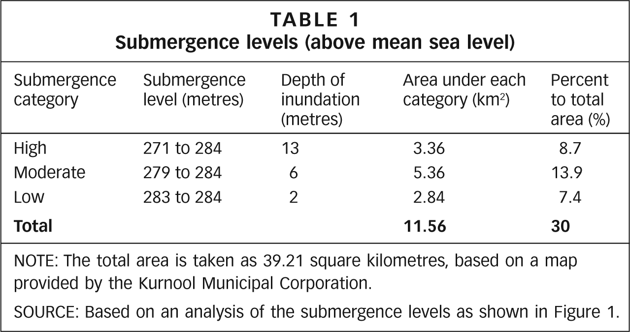
NOTE: The total area is taken as 39.21 square kilometres, based on a map provided by the Kurnool Municipal Corporation.
SOURCE: Based on an analysis of the submergence levels as shown in Figure 1.

Submergence levels in Kurnool town
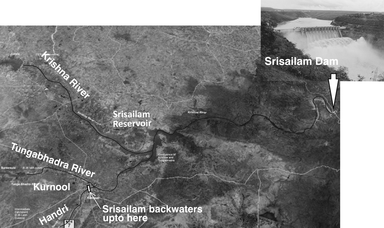
Location of Kurnool town, Srisailam reservoir and dam
Twenty-one wards were completely submerged, affecting about 42 per cent of the population, or about 195,000 people (Table 2). These wards constitute only 4.59 square kilometres (11.71 per cent) of the town, indicating the very high population density in the affected areas. These are also the areas where submergence levels were highest and where the water took more time to recede. In another 10 wards, the submergence levels were 50–99 per cent, affecting a further 14.13 per cent of the population. These 31 wards, together accounting for 25.84 per cent of the town’s area and 56.1 per cent of the population (about 260,000), were badly affected by the floods.
Area and population affected by submergence, Kurnool
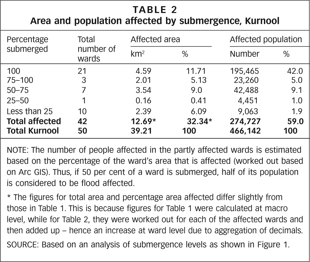
NOTE: The number of people affected in the partly affected wards is estimated based on the percentage of the ward’s area that is affected (worked out based on Arc GIS). Thus, if 50 per cent of a ward is submerged, half of its population is considered to be flood affected.
The figures for total area and percentage area affected differ slightly from those in Table 1. This is because figures for Table 1 were calculated at macro level, while for Table 2, they were worked out for each of the affected wards and then added up – hence an increase at ward level due to aggregation of decimals.
SOURCE: Based on an analysis of submergence levels as shown in Figure 1.
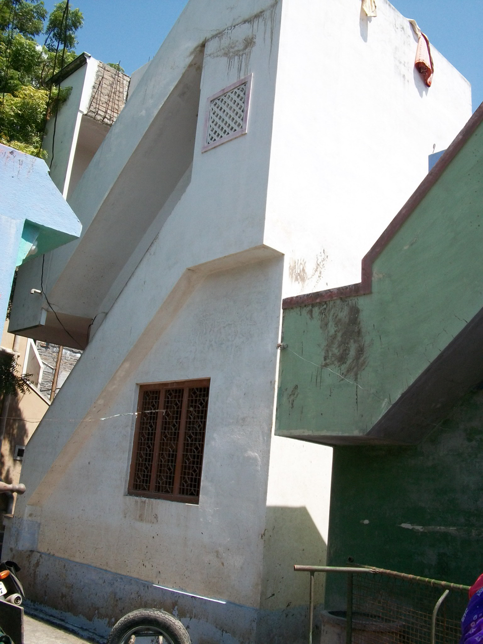
Watermark of the flood
Iii. Official responses
The 2009 guidelines of the Revenue (Disaster Management) Department of the government of Andhra Pradesh provide details of the standard operating procedure (SOP) for the management of relief and rescue operations in times of cyclone, flood and heavy rain. The SOP is supposed to be operationalized 48 hours before an impending event or as soon as warnings are received from the relevant organizations at the state and central (all-India) level. It involves setting up a state control room at the state headquarters (in Hyderabad), with clearly defined roles for different officers. Annexure–3 of the SOP, entitled Important Instructions to District Collectors clearly mentions the arrangements to be made 48 hours and 24 hours in advance. These include: setting up a district control room; preparing the cyclone shelters and ensuring that hygienic food and drinking water is available for the sheltered victims; providing for an emergency supply of drinking water; stocking adequate quantities of drugs; arranging search and rescue teams for relief operations; and maintaining hygiene in the relief camps. Regarding monetary relief, the SOP specifies the amounts to be paid to individuals, based on injury or death, and to households, based on the extent of damage to their homes. It also talks about compensation for clothing and utensils for the families whose houses are washed away or very extensively damaged.
At the state level, the management of floods, cyclones and heavy rains is under the overall guidance and control of the Commissioner (Disaster Management). At the district level, the Collector is expected to be proactive, leading and supervising the entire operation. The experience in Kurnool reveals that the SOP was not followed in full. The administration was inadequately prepared to handle the heavy flooding and evacuate people in a short space of time. For example, the batteries for the cell phones of several senior officers in Kurnool were exhausted due to their continuous use on 1 October. When the calamity struck on 2 October, many of them were left with non-functioning cell phones, which could not be recharged because of power cuts that had also affected the non-submerged areas.(13)
One of the reasons for the low level of preparedness is that Kurnool does not fall into the flood and cyclone-prone areas of Andhra Pradesh, and a flood of this intensity was not expected. There are, for instance, no purpose-built relief camps in the area. Another reason could be political, as discussed earlier, related to the death of the then Chief Minister. The active response of the official machinery was more evident in the post-flood reconstruction process, especially in the massive clean up and restoration of water and sanitation services.
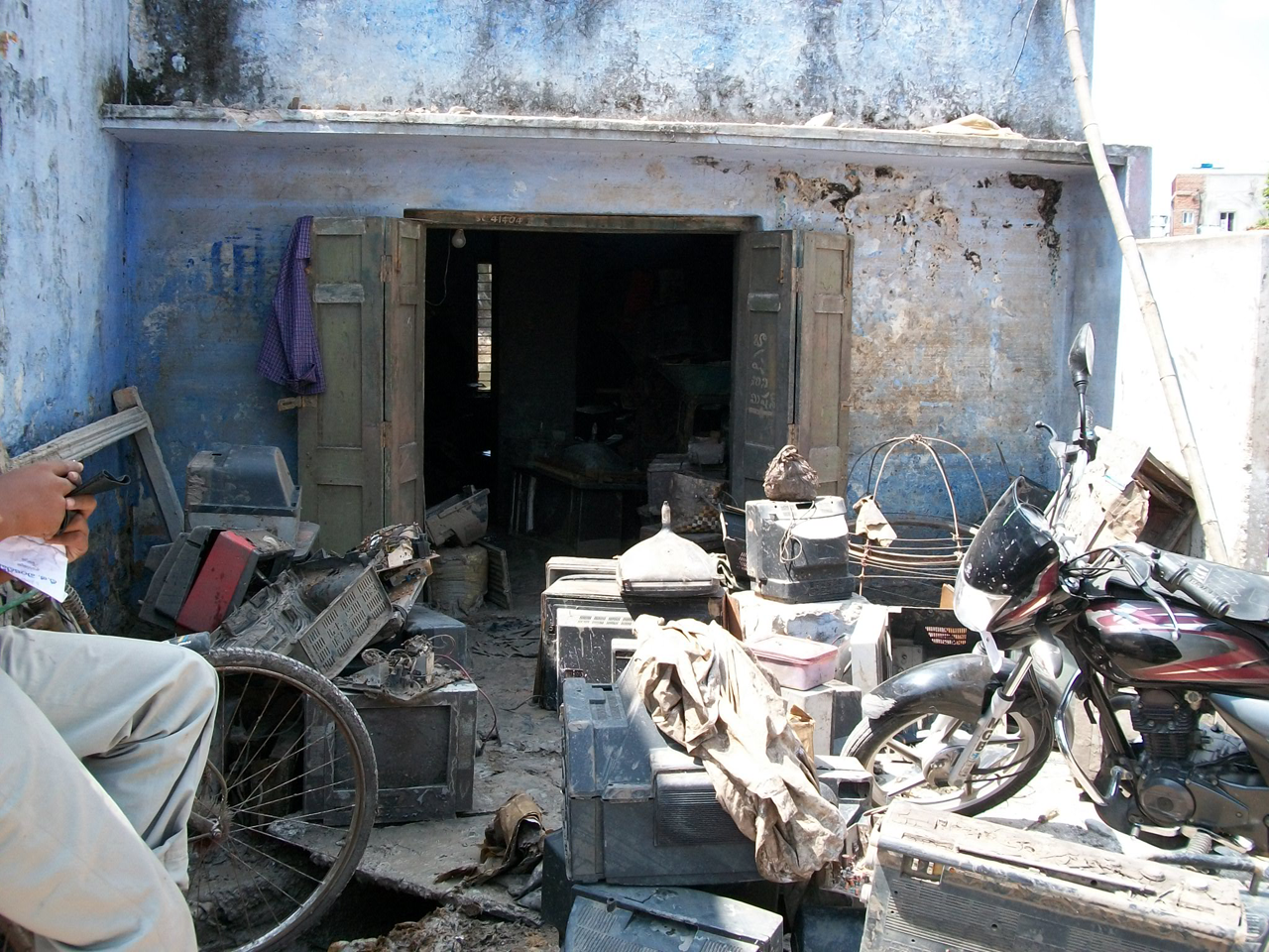
Household items reduced to waste
a. The clean up
The removal of silt and debris was a major challenge for the authorities. Most household items, food grains and other consumables stored in houses and warehouses were reduced to waste. In a massive operation, the government mobilized hundreds of officers, workers and machinery from 35 urban local bodies in Andhra Pradesh to clean up the town. Over the course of a month, 9,568 vehicles and 56,305 workers were deployed in the clean up operation. About 130,000 tonnes of garbage and debris are reported to have been removed. To prevent any outbreak of disease, about 500 tonnes of bleaching powder was sprinkled over the flood-affected areas.(14) The KMC controlled water contamination by regularly mixing in chlorine and constantly monitoring the level for several days at various points in the distribution system. Chlorine tablets were also distributed on a large scale to people in the relief camps and to households to add to their water containers. As a result, there was no outbreak of water-borne disease in the flood-affected areas.
b. Water, sanitation and public health
The two main sources of water supply to Kurnool town are the Tungabhadra River and the Kurnool–Cuddapah (KC) Canal. The present supply is about 45.5 million litres per day, which works out to about 113 litres per capita per day. There are 31,134 house service connections, 1,810 public stand posts and 1,290 hand pumps (of which 61 are reported to be dry) in the town. Water is supplied daily for 2–3 hours in about 65 per cent of the area and on alternate days in the rest of the town.(15) The pumping stations suffered damage to their high capacity pump sets and electric transformers as a result of submergence, and the infiltration wells also suffered damage. While garbage was being removed from the streets and drains, about 200 metres of water distribution pipeline and 300 house service connections were damaged. Hand pumps (numbering 270) were also damaged due to submergence. The KMC claims that most of the damaged water supply systems were repaired and restored within a few days,(16) but be that as it may, in the 2–3 weeks following the floods, water supply needs had to be supplemented from tankers supplied by the KMC (including those obtained from other local government bodies) and private agencies. Drinking water needs were met largely by the water sachets distributed by a number of private agencies at the relief camps and to households in different localities.
Kurnool town has neither a centralized sewage system nor a sewage treatment plant. It relies largely on septic tanks, hence silt did not block the entire system. According to the KMC, between 21 October and 5 November, 339 septic tanks were identified as overflowing and were cleaned.(17) However, one might view these claims with some reservations given the experience of civil society groups, who had to exert pressure on the KMC to get schools’ septic tanks cleaned, for example at the government Girls Urdu High School.(18)
c. Health care services
The role of the government with regard to maintaining public health focused mainly on preventing the spread of epidemic diseases, through cleaning up the streets, sprinkling bleaching powder, fogging (spraying of an insecticide, even in the late evenings) against mosquitoes, maintaining water quality through chlorination etc. “That is why we are saved from public health-related diseases” was the unanimous opinion of the participants in all the focus group discussions.
For about a month during the traumatic post-flood period, the government made its medical emergency services available to provide free treatment. Mobile health care units (ambulances marked with the number 104) made periodic visits to different areas for primary health care, and the government also made emergency ambulances (identified by the number 108 and run in partnership with the private sector) available to provide regular health care services in the affected areas. Some private and charitable hospitals also provided free medical camps. Similar services were made available at the relief camps, but for the most part people only stayed there at night.
d. Distribution of relief materials
Civil society organizations rushed in vast quantities of relief materials, however distribution was a major problem. The relief that poured in immediately was disorganized and those who brought it were in a hurry to distribute it and leave. There was a stampede-like situation every time a relief van arrived at a designated place in a colony where people were already waiting. Several days after the flood, more organized efforts had been put in place, in particular by a Telugu news channel (TV–9) and by the Telugu Desam Party (TDP).
Iv. Focus group discussions
Finding effective ways to improve disaster response calls for a good understanding of the situation from the perspective of those affected, so focus group discussions(19) were conducted in three localities, namely Budhavarpet, Madam’s Satram and Roza Veedhi. These neighbourhoods are geographically spread out in the old town and were all badly affected by the floods. Each of the focus groups comprised about 15–20 persons, mostly women of different age groups although there were also a few men and children. The number of participants was deliberately limited so that meaningful interaction was possible. In each of the neighbourhoods, a local social activist engaged by the research team first discussed the research with a local women’s leader(20)to obtain her cooperation, then people were gathered together at a designated place (a community building in one instance and residences in the other two). There were no specific criteria when identifying the participants – selection was left to the local leader. Word was put out and people came from the immediate area around the meeting place. The majority of inhabitants in the three localities are dalits (in Budhavarpet), Muslims and from the “backward classes”(21) (in Madam’s Satram and Roza Veedhi). Only one meeting was held with each group.
The participants narrated their experiences in a free and frank manner and went beyond the planned scope of the discussion, pouring out their emotions and grievances while recollecting their harrowing experiences. These are summed up in the following sections.
a. Immediate crisis and the rescue operation
The local people were highly appreciative of the role of the police in issuing warnings and helping with the evacuation, but many felt that the response had been far from adequate. “Government has to inform us properly beforehand” recalled a woman at Madam’s Satram. “We were not informed. I got a phone call from Veligonda (neighbouring town). Some of us who had mobile phones were saved.” Many of the affected people were unwilling to vacate their homes and move to relief centres for fear of theft. In the crisis, young men were invaluable in helping people to move from one building to another, to cross flooded streets and in helping senior citizens and children to reach safer places and the relief camps.
In Madam’s Satram area, floodwater had entered all the houses by 10 am on 2 October. There was no time to take any belongings and people spent up to 48 hours perched on top of buildings. To prevent short circuits, the authorities had disconnected the power supply and people were forced to seek out safe places in total darkness. One woman recollected:
“Walking on and along the walls we reached the road on Friday night (2 October, the day of maximum flood). Some of us went to the Collector’s bungalow, some to the church and some others went to their relatives’ houses. Some thousands of people were there on roads for three days. So many belongings have been washed away in the floods; we didn’t feel like having our food even.”
Other participants concurred with her. Rumours of further inundation, to the extent of washing away the entire town, created a sense of panic. Months later, memories of helplessness and of running to safety continued to haunt people. Private boatmen had demanded exorbitant amounts (in cash or kind, for example gold ornaments) to rescue people: “They were demanding Rs 5,000. I only had Rs 10 at that time. . .” recollects a sobbing woman. The fact that income levels played such a key role in this situation left a bad impression in people’s minds. It also highlighted the failure of the government to rein in the boatmen.
“On Thursday (1 October) night we went to the terrace” said one woman in Madam’s Satram. “For 48 hours we were there. It was even slightly rainy. We were about 50 people there without food and water. Children were weeping. We stayed there under the umbrellas in the rain.” “In our group there was a woman who delivered a child a week before” another woman from Roza Veedhi recalled. “We were helplessly sitting, even then. And there was another lady who had been operated on just a few days before. What else could we do? Later we carried her in a chair to the relief camp. Alas! In that process she was dropped in the water. Anyway, she is fine now!”
b. The “relief camps”
There were no formally designated relief camps in the area but people made use of any public building or space available, including the railway station, a school, a mosque and the Collector’s bungalow – an office complex with a large gathering space. These buildings were not designed to accommodate such large numbers of people and lacked necessary basic facilities. They were called “relief camps” simply because they were places people could reach and take shelter in this desperate situation – although the shelter was far from adequate. All the buildings were located less than two kilometres from the inundated areas and there were no special arrangements to transport people. It was a “run for your life” situation; on 2 and 3 October people could think of nothing beyond saving themselves from the disaster.
c. Distribution of relief
Participants were highly appreciative of the relief rushed in by civil society organizations and found their responses to be more effective than those of government. However, the initial chaos was troubling to many. Outsiders bringing in relief in vans did not know who the really affected people were, and a large number of people from non-affected areas would also wait in the crowd and grab relief supplies. Households with no able-bodied male members and those in the narrow interior lanes were at a particular disadvantage. Middle-class families, many of whom became paupers overnight, found it very difficult and degrading to rush in and push to get anything. They suffered silently and cursed their fate:
“We could not get into that crowd and jostle for the relief. Both physically and psychologically it was difficult. We are not used to that. It was like begging, even worse than that” said a middle-class woman in Budhavarpet.(22)
Generally, the most effective distribution method was felt to be that adopted by a Telugu news channel (TV–9), which distributed coupons to every house even if the inhabitants were not present. The affected people could come to a designated area with the coupons and collect relief materials. Nobody was left out. The Telugu Desam Party (TDP) also organized massive relief in a similar way but without distributing coupons, and here again, those who lived in the narrow interior lanes or who were not present at the time of distribution were left out.
d. Water and sanitation in the relief camps
The government machinery was not well enough prepared to provide water and sanitation facilities to the buildings that were used as relief camps. While drinking water was provided in the form of water sachets, sanitation was a major problem. People somehow endured the inevitable and typical comments included the following:
“In the church’s compound there were toilets but there was also a foul smell all around.” “In Balabharathi school we carried water and used the toilets. Because the area was less muddy, somehow we managed to go with the help of a stick. . .”
And,
“. . .we went out into the fields for sanitary purposes. Some were forced simply to squat wherever they could.”
Those who were perched on top of buildings for more than 24 hours also had the worst kind of memories, especially the women: “Some of us controlled ourselves by God’s grace. We were about 50 people on the terrace. There was some space on the terrace. We used that space as a toilet” recollected one woman from Roza Veedhi.
e. The clean up
The clean up after the water receded was a major challenge. Although government was very much involved in the more general clean up, people had to deal with their own homes. One woman recalls:
“When we came back to our homes, all our clothes and other household items were full of mud. Up to two feet of silt was spread in the houses. Many of our belongings were either washed away or stolen by thieves. In the process of cleaning we were affected by skin infections. Doctors conducted health camps for about 10 days. They supplied us with tablets for cleansing drinking water and against allergy and body pains. Government gave us tablets for mixing in the tap water.”
People cleaned their houses during the day and either went back to relief camps or to relatives’ places at night. This went on for about 20 to 30 days.
Many people left their small children with relatives either in the same town or in the neighbouring villages and towns during the clean up process. For about a month the affected areas smelled foul, with tonnes of garbage, damp mattresses and soaking bags of grain thrown onto the roads. People claimed they would not wish this experience even on their enemies.
No support was available for cleaning up. Some people came from rural areas and charged Rs 5,000 per house for cleaning. After 20 days, when the process was still not completed, some people paid Rs 1,200–1,800 to have the job finished. Some also paid to have their clogged toilets and pipes cleared. Several women in Roza Veedhi said:
“Government did not help us in this regard. Even after three months the condition of the toilets has not improved. They helped us only in pumping out water. The mud from the pipes was removed by private contractors who charged us Rs 1,500–2,000.”
f. Water supply and sanitation during the rebuilding stage
Although the KMC repaired much of the damage to the local water system, people who consumed municipal water experienced discomfort and later shifted to packaged water. “The tap water in the beginning was red in colour, looked like muddy water, and it made us sick to our stomachs” said a woman at Budhavarpet. Boys played a key role in collecting water packets for their families and sometimes people had to purchase them. Clean water for other purposes was hard to come by and many of the affected people said they didn’t bathe for about 10 days.
The local legislator supplied a liquid, locally called “hypo”, which could be sprinkled around to cope with the foul smell. Some liquid was also supplied for easy cleaning of the toilets.
In the initial days following the flood, when the toilets were silted up and not in usable condition, it was challenging for people to attend to their needs. Some women acknowledged that they used old clothes, donated as part of the relief effort, to defecate inside the house. “Then we threw them into the garbage outside” said a middle-aged woman, clearly embarrassed by the admission. Several other women nodded silently.
Although the municipality was involved in the cleaning and repair of many sanitary facilities in the weeks after the flood, household and community toilets in localities inhabited by low-income people and those of lower castes evidently received low priority. According to participants in discussions, the community toilets in Budhavarpet (a low caste neighbourhood) continued to be unusable even months after the floods. Out of 16 units only three could be used several months later. About 1,000 families, mostly dalits, depend on these toilets. They are now forced to use the open spaces of the nearby KC Canal and graveyard for defecation.
g. Solidarity
The traumatic times during the floods brought out the best in people. There was considerable mutual support and aid and the affected people felt that nature had eliminated the differences between people, even if only temporarily.
However, there was also cause for hurt feelings in some situations. Specifically, in the post-flood recovery process some people who came from outside were interested in offering help only to people from their own caste or group, and this caused ill-feeling. This opinion was commonly expressed in all the focus groups. The same was clearly true in terms of the inequitable municipal responses, as noted with regard to community toilets in Budhavarpet. The lack of interest and compassion was sorely felt by many, and the participants in the focus groups made it clear that they were thankful to the research team for the opportunity to be heard. This is how they expressed it:
“Nobody visited us to share our experiences during floods or later. Today, we feel a sense of relief and happiness that we could talk to other persons who were not affected by the crisis. We will never forget your patient hearing of all of us.”
V. Conclusions and recommendations
Based on the experience of the Kurnool floods, as reported by both the authorities and the affected people in the focus groups, this study proposes various findings and recommendations that can form part of a policy framework to cope with this kind of calamity in an urban area.
It is crucial to disseminate prior information and warnings on the likely scope of flooding, based on the amount of rainfall and other factors. The public should receive credible warnings. Often people find it hard to imagine how serious a threat can be. People’s representatives and civil society organizations should be taken into the local administration’s confidence and credible information should be passed onto people.
Providing sufficient security in the vacated areas is of utmost importance in convincing people to leave their homes and move to relief camps. Without this, they are likely to be afraid of losing their valuables to theft when the whole area is evacuated. It should be possible to identify certain strategically located buildings where security posts can be set up, with the prior understanding of owners. Such security posts should be provided with an electricity generator to supply power (since the power supply is disconnected in such situations) and also a public address system for disseminating correct information to the public. This will greatly help in building confidence and avoiding rumours.
In the early stages of flooding, when the power supply was disconnected, the affected families were unable to get updated information from the television (if they had one). Mobile phones provided the main source of communication with friends and relatives. One suggestion was to keep an adequate number of stand-by generators ready at least 48 hours in advance to supply power to the relief camps and the monitoring centres. Cell phone recharging facilities should be available at these places so that neither officers nor affected people are left without communication devices at crucial times.
Even in areas that are not normally considered to be at risk of disaster, it is clear that some form of preparation for housing people and dealing with their basic needs is essential. At the very least it should be possible to temporarily provide converted relief camps with basic provision for sleeping, eating and water and sanitary purposes, with women, children and the elderly as the main focus.
The role of the media and civil society has become crucial in informing people during rescue and relief operations and the post-flood recovery process. The flow of aid from civil society was instant and massive. In advance of any calamity, the administration must put in place a coordinating mechanism with the media and civil society groups to assist in and manage the rescue and relief operations.
The Kurnool experience shows how the lack of coordination affected the distribution of relief materials, resulting in some people, including unaffected ones, cornering more than others. The advance distribution of coupons to each house worked more effectively and equitably in Kurnool.
The distribution of chlorine tablets to affected people for them to mix with water in their homes and chlorination of the water distribution system for at least 2–3 weeks helped prevent water-borne diseases.
In a post-flood situation, the provision of a minimum quantity of drinking water to each household should be the highest priority. The availability of bottled/packaged water provides a huge opportunity to meet such needs. The coupon system can also be adopted for the distribution of drinking water on a per capita basis.
Government assistance, which should at the very least be equitably applied, should encompass a broader framework for restoring livelihoods and compensating for loss of income, rather than mechanically fixing a certain amount based on damage to the house, as stipulated by the standard operating procedure. Even when the houses are not damaged, submergence of the house and the loss of household items saved over years of hard work can push the affected people into poverty for a long time. Non-salaried people such as small business individuals and daily wage earners forego several days of work in the post-flood period.
Allowances for house cleaning and basic sustenance for disaster-affected people should be considered as integral to policy responses. The basic sustenance allowance could be equivalent to the prevailing daily wage and be paid until normalcy prevails in the affected areas. School children who lose their books should get assistance and their fees could be waived. The specific modalities for these kinds of responses should be worked out with the involvement of local level committees.
From the humanitarian point of view, it is of utmost importance that the affected people during the calamity, and even more so in the post-flood recovery process, be treated with fairness and empathy. Making them feel that they are cared for and involving them in the local reconstruction process will go a long way in assuaging their feelings and helping them to recover from their traumatic experiences.
Footnotes
Acknowledgements
Thanks are due to Amit Pande and Hemalatha Patil, WaterAid in Bengaluru; Durga Prasad, Kurnool Municipal Corporation; Lakshmi Kantham, Joint Collector, Kurnool District; Suresh and Abdul Rahiman of Jana Vignana Vedika, Kurnool; Dr G Rama Padma of the Indian Institute of Health and Family Welfare, Hyderabad; Umesh Verma, a social activist in Hyderabad; and the anonymous referees.
2.
Dutta, Dushmanta and Srikantha Herath (no date), “Trend of floods in Asia and flood risk management with integrated river basin approach”, accessible at ![]() .
.
3.
Douglas, Ian, Kurshid Alam, MaryAnne Maghenda, Yasmin McDonnell, Louise McLean and Jack Campbell (2008), “Unjust waters: climate change, flooding and the urban poor in Africa”, Environment and Urbanization Vol 20, No 1, April, pages 187–205.
4.
Revi, A (2005), “Lessons from the deluge: priorities for multi-hazard risk mitigation in Mumbai”, Economic and Political Weekly Vol XL, No 36, pages 3911–3916.
5.
See reference 3.
6.
Chigurupati, R (2008), “Urban growth, loss of water bodies and flooding in Indian cities: the case of Hyderabad”, in J Feyen, Kelly Shannon and Matthew Neville (editors), Water and Urban Development Paradigms: Towards an Integration of Engineering, Design and Management Approaches, Proceedings of the International Urban Water Conference, Haverlee, Belgium, 15–19 September, CRC Press/Balkema, Taylor & Francis Group, London, pages 121–125.
7.
See reference 1.
8.
Adger, W Neil, Saleemul Huq, Katrina Brown, Declan Conway and Mike Hulmea (2003), “Adaptation to climate change in the developing world”, Progress in Development Studies Vol 3, No 3, pages 179–195.
9.
Some of the rain gauge stations might have already been submerged or were non-functioning on 1 October and hence were reported as “not available” for rainfall calculation on 2 October.
10.
Raju, I S N (2010), “Flood mitigation of Kurnool town”, Paper presented at a one-day seminar on Recent Floods in Andhra Pradesh – Retrospect and Prospect, Hyderabad, India, 12 January.
11.
See reference 10.
12.
Srinivas Rao, A (2010), “Srisailam dam in October floods”, Paper presented at a one-day seminar on Recent Floods in Andhra Pradesh – Retrospect and Prospect, Hyderabad, India, 12 January.
13.
Based on discussions with officers of the Kurnool Municipal Corporation.
16.
See reference 14.
17.
See reference 14.
18.
“After the floods in Kurnool we visited a girls’ high school which had 800 students. Its toilets were all clogged up after the floods. We approached the District Collector, Education Officer, Municipal Corporation, local Corporator, MLA and MP and then finally the Human Rights Commission. After all this pressure, the School Education Board moved and is now working on it.” (e-mail correspondence from Mr Khalid R Khan, 21 December 2009.)
19.
Focus group discussions were held in February 2010.
20.
These leaders were not affiliated to any political party. They were either social activists or community leaders.
21.
In India’s formal caste hierarchy, the caste groups defined as “backward” fall between the upper castes and the scheduled castes (dalits) and tribes.
22.
This was in conversation with the research team members in a street in Budhavarpet before the focus group discussions. The participants in these discussions broadly agreed with this predicament of the middle class, who were otherwise relatively better-off.