
Abstract
The genetic relationships between the stratigraphic textures, thickness changes, burial depths, and the characteristics of the geothermal zoning of the Cenozoic in the northwestern Shandong region were analyzed in this study. Methods involving segmented water temperature measurements of geothermal well drilling, wellhead hydrological surveys, geothermal reservoirs, and caprock thickness measurements and statistics were adopted. The following findings were revealed in this study's research results: (1) The Paleogene and Neogene reservoir types in the northwestern Shandong region were determined to be mainly water-bearing fine sandstone and medium-fine sandstone pores, with thick layered, interbedded, and zoned stratigraphic structures. The layered and zoned geothermal reservoirs were found to be primarily distributed in a zonal manner on the bedding plane and characterized by good regional continuity. The fine sandstone and medium-fine sandstone sections with well-developed pores and high water content levels were geothermal reservoirs, while mudstone sections were geothermal barriers. The reservoirs and barriers were characterized by interlayer structures; (2) The boundary between the sag basin and the uplifting was taken as the dividing line of the geothermal fields, and the geothermal areas in the northwestern Shandong region were divided into different geothermal fields, all belonging to the sedimentary basin's conductive geothermal resources; (3) The major geothermal reservoirs included the lower members of the Neogene Minghuazhen Formation, Guantao Formation, and Dongying Formation. The Quaternary argillaceous sediment and the mudstone in the upper member of the Minghuazhen Formation formed the caprocks in the study area. In this study, the macroscopic distribution laws of geothermal resources in the northwestern Shandong region were proposed and were considered to have practical significance for further exploration and development.
Keywords
Introduction
Geothermal resources are derived from the molten magma in the deep earth, friction heat generated by tectonic activities, or the decay of radioactive substances. Geothermal resources can be categorized as renewable heat energy and are considered to be quite valuable comprehensive energy resources (Liu et al., 2021). The formation of geothermal resources depends on such key conditions as heat sources, geothermal reservoirs, and caprocks (Liu et al., 2022). Specifically, geothermal reservoirs and their caprocks are the most important and basic geothermal geological conditions.
With the development of the world's societies and economies, the consumption levels of fossil and other traditional energy have become huge, and the production costs have been increasing rapidly. What is worse, the massive consumption of fossil energy has brought serious pollution to human living environments and reduced the quality of life (Wang et al., 2014; 2019; Yang et al., 2022; Zhao et al., 2021; 2023). Therefore, the research and development of geothermal resources have both practical value and far-reaching significance.
Investigations of high-temperature geothermal systems are important research directions in the geothermal field. In China, thermal springs with temperatures greater than 80 °C are mainly concentrated in specific regions, including southern Tibet and the western Sichuan and Yunnan regions of Taiwan. The former is the eastern branch of the global Mediterranean-Himalayan Geothermal Belt (also referred to as the Himalayan Geothermal Belt), which belongs to the continent–continent collision plate marginal nonvolcanic geotropic zone (Chen et al., 1994; Guo, 2012). The latter is part of the Circum-Pacific Geothermal Belt (Chia-Mei et al., 2011). From the perspective of geotectonic settings, the Himalayan Geothermal Belt is considered to be a subduction-type plate marginal geothermal belt (Guo et al., 2007).
It has been determined that the formation of geothermal resources is closely related to the characteristics of the deep magma, structural features, geothermal reservoirs, and caprocks of the earth. Previous studies of the deep heat supplies in the Tibetan hydrothermal region have revealed that the high-temperature hydrothermal region is characterized by deep heat supply sources and natural magma pockets (Tong et al., 1982). Based on the comparison results of the change relationships between the dominant frequencies and amplitude ratios of local converted seismic waves propagated in the deep parts of the Yangyi Geothermal Field in Tibet (Zhang et al., 1993), it was determined that there may be partially melting dikes moving along with deep faults within the deeper sections of the geothermal field. In addition, according to the study of two proven high-temperature geothermal fields and eight potential geothermal active areas in Iceland (Stefan, 1995), high-temperature underground geothermal reservoirs have been filled in the Quaternary and Tertiary aquifers, with maximum temperatures of up to 380 °C obtained from drilling records. The Tengchong high-temperature geothermal active area in Yunnan is a geothermal field formed by the intrusion of mantle-derived magma (Shangguan, 2000). The geothermal fluid discharge is controlled by three groups of active faults with different depths and has the characteristics of multilayered geothermal reservoir structures. In addition, based on the study of the Yangbajing Hot Springs, a typical high-temperature geothermal field in Tibet, it has been determined that the geothermal field in the region is composed of both shallow and deep geothermal reservoirs in different locations and at different depths in the same hydraulic system, A local melting body has also been observed in the upper crust of the geothermal field (Duo, 2003).
The sources of heat have been studied from many aspects, such as the study of F and SiO2 in the high-temperature geothermal water of Yellowstone National Park in the United States (Garrott et al., 2002); studies of the sources of the hot water in the Chios geothermal field in Iceland using fluid geochemistry (Dotsika et al., 2006); and research regarding the sources and mixing processes of deep and shallow geothermal reservoirs (Guo et al., 2007, 2010). It has been determined from the results of the abovementioned studies that deep geothermal reservoirs are primarily formed by the mixing of the water from melting ice and snow and magmatic water. Meanwhile, the studies of the deep structures of geothermal fields have revealed that the temperatures of geothermal reservoirs in the deep sections of geothermal fields are approximately 400 °C at buried depths ranging between 660 and 785 m (Deng, 2009). In addition, the geochemical research in the Nimu-Naqu high-temperature geothermal belt of the geothermal fluid in high-temperature geothermal systems has confirmed that isotopic geochemical characteristics may be used to reveal the existence of mantle-derived material release activities (Liu et al., 2014). Generally speaking, a great deal of progress has been made in the study of the hydrogeochemical processes in geothermal systems, as well as the sources of F, Cl, B, and As plasma in high-temperature geothermal fluid. Furthermore, previous studies have increased the understanding of the heat sources, materials, and temperature levels in geothermal reservoirs, as well as introducing methods for effective resource utilization while controlling environmental impacts and maintaining solubility equilibrium (Ballantyne and Moore, 1988; Stefan, 1995; Wang et al., 2002; Liao et al., 2005; Guo et al., 2007, 2010; Majumdar et al., 2005, 2009; Saibi and Ehara, 2010; Asta et al., 2012; Purschel et al., 2013; Grassi et al., 2014). Good results have been achieved in terms of the formation conditions and favorable area predictions of deep geothermal resources (Guo et al., 2020); hot spring characteristics and the genesis of geothermal water (Gao et al., 2009); and the distribution characteristics and accumulation mechanism of geothermal energy in basins (Yan et al., 2013).
Medium-low temperature geothermal systems are another important research field, particularly medium-low temperature convective geothermal systems (Wang et al., 1996; Wen et al., 2014). There are no special additional heat sources in the medium-low temperature geothermal systems. However, sufficient geothermal water and a certain circulation depth are required. China's medium-low temperature geothermal resources are mainly distributed in the interior regions of the continental plate. For example, the continental crust uplift areas and the crustal subsidence areas. Previous research studies regarding geothermal energy have mainly focused on shallow geothermal resources, with more consideration given to the environment and the efficient realization of geothermal heating (Zhu et al., 2019; Yan et al., 2019). In this study, a conceptual model of the geothermal system of the area was established based on the analysis and study of the main geological factors of the geothermal system sources, reservoirs, passageways, and caprocks in the sag region of the Linqing Depression, Shandong Province (Gao et al., 2021).
In terms of geothermal research and exploration methods, in-depth explorations have also been carried out. Such methods include the ultra-high temperature logging technology used in geothermal well explorations (Wu, 2018), and the development of digital thermometers for groundwater temperature readings in boreholes (Niu and Wu, 2008). In addition, advancements have been made in the analysis methods and testing technology used in geothermal fluid resource development (Li et al., 2018), which now have important roles and value in accurately detecting the distribution patterns of geothermal resources.
The distribution, exploration, development, and utilization of geothermal resources in Shandong Province (Xu et al., 2015; Li et al., 2021; Meng et al., 2021; Liu et al., 2018), along with the chemical characteristics of geothermal water (Liu et al., 2010) and the evaluations of geothermal resources in plain areas (Zhu et al., 2016), are all important advances and achievements which have been made in geothermal research in Shandong Province. Moreover, research studies in those fields have led to the development and utilization of geothermal resources in sandstone geothermal reservoirs (Qin and Zhang, 2018; Wang et al., 2021; Feng et al., 2019).
The abovementioned research on various aspects of geothermal systems has made important progress. In particular, the research results regarding geothermal reservoir mechanisms and caprocks reflect the fundamental values of geothermal resource formations. However, the common problem lies in the fact that the research which has been conducted on the various strata types and their lithology, such as the structural characteristics and distribution patterns of sandstone, has not been precise enough, which has affected the accurate exploration and predictions of geothermal resources. In order to address those issues, this study selected the northwestern Shandong region as the anatomical point. The characteristics of the region and the formation mechanism of the geothermal reservoirs and caprocks in the relevant depressions located in northwestern Shandong Province were discussed in depth. The analysis of the genetic relationships between the stratigraphic textures, changes in thicknesses, burial depths, and so on from a macro perspective was the main focus of this study, as well as the characteristics of the geothermal zoning in the region.
Tectonic characteristics and geothermal zoning of Shandong province
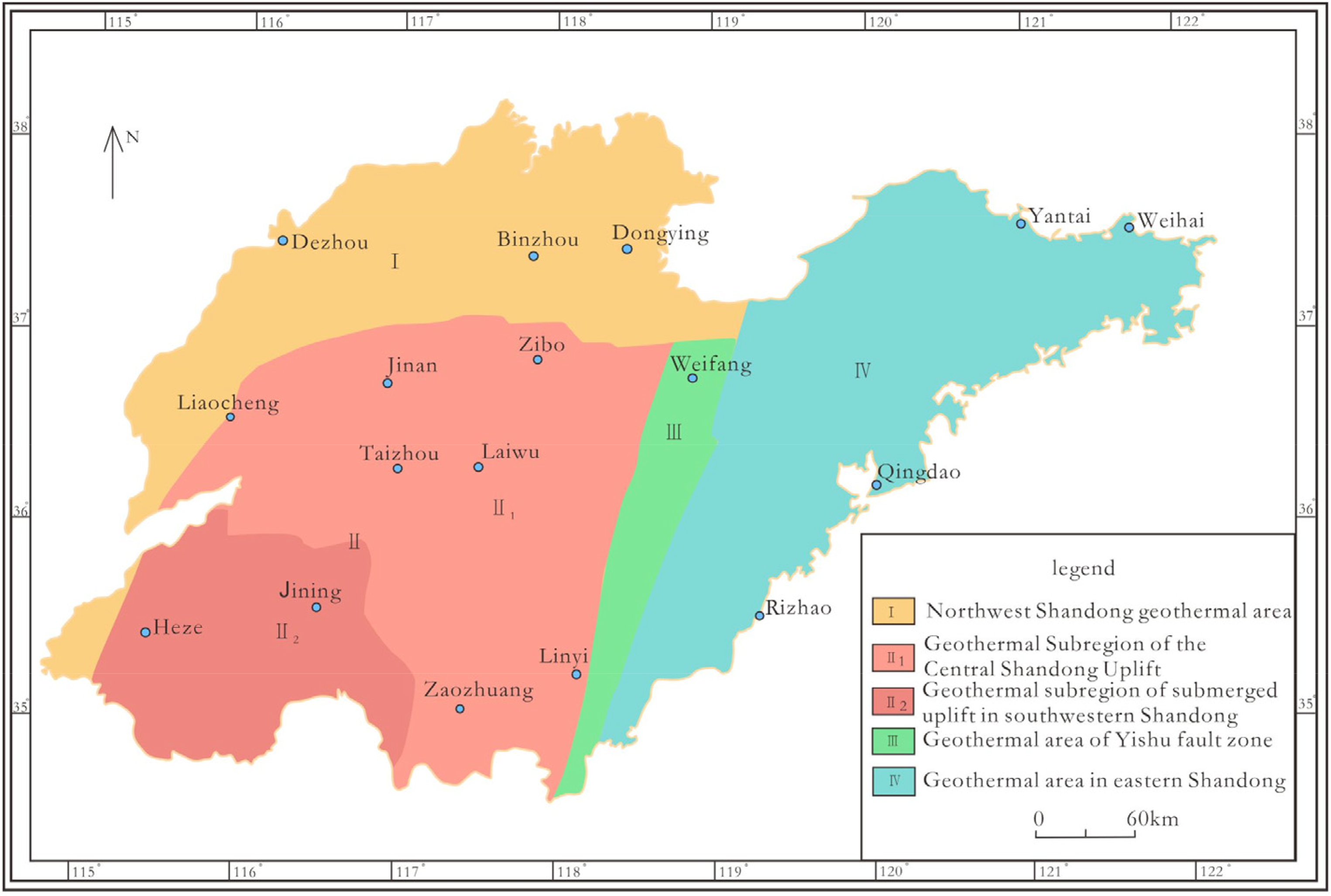
The basement structure in Shandong Province is known to be relatively complex and dominated by a series of folds. The basement has undergone strong regional metamorphism and migmatization, and the fault structure is also extremely developed. In terms of the geological tectonic unit division, the Shandong block is located in the North China Plate and the Qinling-Dabie-Sulu orogenic area of the first-order tectonic unit (Sun et al., 2017). The second-order tectonic unit is divided from west to east into the Northwestern Shandong Depression, West Shandong Uplift, Jiaoliao Uplift, Jiaonan-Weihai Uplift, and Northern Jiangsu Uplift, respectively. The second-order tectonic units from west to east include the Linqing Depression, Jiyang Depression, Central Shandong Uplift, Southwestern Shandong Sub-uplift, Yishu Fault Zone, Jiaobei Uplift, West Jiaolai Basin, East Jiaolai Basin, Weihai Uplift, Jiaonan Uplift and Haizhou Uplift, respectively, as illustrated in Figure 1.
Zoning of the geothermal resources in Shandong province.
Shandong Province is located in the collision zone between the North China Plate and the Yangtze Plate and is characterized by a high terrestrial heat flow. It is a major province of geothermal resources in China due to its many types and wide distribution of geothermal reservoirs, abundant resource reserves, and good mining conditions (Figure 1). In this study, based on the aforementioned attributes, Shandong Province was divided into four geothermal resource areas as follows: Northwestern Shandong geothermal area; West Shandong Uplift geothermal area; Yishu Fault Zone geothermal area; and East Shandong geothermal area. Among those areas, the West Shandong Uplift geothermal area was further divided into the geothermal subarea of the Central Shandong Uplift and the geothermal subarea of the Southwestern Shandong Sub-uplift, as detailed in Table 1. The geothermal resources in the East Shandong geothermal area, Yishu Fault Zone geothermal area, and the Central Shandong Uplift geothermal subarea were classified as the convective geothermal resources in the uplift mountains. Meanwhile, the geothermal resources in the Northwestern Shandong geothermal area and the Southwestern Shandong geothermal subarea were classified as the conductive geothermal resources in the sedimentary basins. The majority of the geothermal resources had low-temperature values, and only a few boreholes had exposed geothermal water with temperatures higher than 90 °C (such as Zhaoyuan and Dongying), belonging to the category of medium-temperature geothermal resources.
List of geothermal resource zoning and reservoir types in Shandong province.
Magmatism is quite frequent in Shandong. It is found from the Archean to the Cenozoic strata, accounting for approximately 20% of the province's land area. According to the distributions and development of magmatic rock during different ages, the Mesozoic magmatic rock in Shandong is the most widely distributed, followed by Neoproterozoic magmatic rock and Paleoproterozoic magmatic rock. It was determined that the Qianxi-Wentai magmatism is relatively strong in Shandong. The Luliang magmatism is the strongest in the western Shandong region, and the Yanshan magmatism is the strongest in the eastern Shandong region.
The northwestern Shandong geothermal areas, which include the areas to the north of the Qiguang Fault Zone and to the west of the Liaokao Fault Zone, are part of the Mesozoic and Cenozoic Fault Basins which developed on the North China Platform. That is to say, the northwestern Shandong region refers to Zone IV in Figure 1.
Formation thickness distribution pattern and reservoir conditions
Cold water layers, hot water layers, and heat-conducting layers in the formation sequence
As a heat transfer medium, the thermal conductivity, thermal insulation, and tectonic conditions of strata composed of different lithology will be quite different. Different types of rock have different thermal conductivity, and the greater the thermal conductivity, the better the thermal conductivity and thermal conductivity properties will be. Since high thermal conductivity is conducive to the upward migration of geothermal energy, the stratigraphic texture and its characteristics are relatively important factors for the formation of geothermal systems. In accordance with the thermal conductivity of rock, as well as geothermal generation and occurrence characteristics, strata in the study area was divided into three types: Cold-water layers; hot-water layers; and heat-conducting layers, as described in the following:
Cold-water layers: The cold-water layers were composed of Quaternary overburden with strong alternations of groundwater. This type of strata was widely distributed in the plain area, fault basin, and the main drainage basin of northwestern Shandong. The strata was characterized by loose texture, low density, intense water exchange, poor thermal conductivity (generally below 18.92 × 10⁻³J/s·cm·°C), and good thermal insulation effects. Therefore, it was considered to be an ideal reservoir caprock and played an obvious thermal insulation role on the underlying geothermal reservoir. However, as a loose sedimentary layer, it was prone to water filling, and its geothermal gradient was relatively low when compared with the Paleogene and Neogene. Hot-water layers: The hot-water layers were composed of sedimentary strata from after the Archean and mainly consisted of extremely thick stratum which had been deposited since the Paleozoic Era. As relative geothermal reservoirs or caprock, the strata thicknesses were observed to be relatively stable, which was also conducive to heat storage and thermal insulation. The sections with high water content were geothermal reservoirs, and the sections with low water content were considered to be geothermal barriers. The reservoirs and barriers were found to be interbedded. The rock densities of the relative thermal insulation layers ranged between 1.9 and 2.5 g/cm3. The thermal conductivity was between 18.92 and 23.99 × 10⁻³J/s·cm·°C, and the thermal insulation effects were obvious. The rock densities of the relative geothermal reservoirs were in the range of 2.4–2.74 g/cm3, the thermal conductivity was 19.55–47.56 × 10⁻³J/s·cm·°C, with obvious relative heat conducting effects observed. Moreover, there was underground water in the rock gaps which was conductive to heat conduction, thereby making the hot-water layers ideal heat-conducting reservoirs. Heat-conducting layers: The heat-conducting layers were Archaean sedimentary strata, and the dominant lithology included gneiss, granulite, and so on. The densities of the rock were relatively large, ranging from 2.65 g/cm3 to 2.89 g/cm3. The texture was observed to be hard, with a high thermal conductivity ranging from 25.41 to 36.30 × 10⁻³J/s·cm·°C, which was considered to be conducive to the upward migration of geothermal energy. In summary, the heat-conducting layers were ideal heat-conducting medium.
Thicknesses, buried depths, and change characteristics of the Cenozoic strata
Since the Mesozoic-Cenozoic Era, the study region has been affected by the Yanshan and Himalayan movements, and for a long period of time, the general trend of the crustal movement was to decline and accept accumulation. As a result, the Cenozoic strata is deposited with a thickness of more than 3000 m, beneath which is the Mesozoic. According to exploration and regional geological data, the strata within a depth of 3000 m mainly includes the Quaternary Pingyuan Formation, Neogene Minghuazhen Formation and Guantao Formation, Paleogene Dongying Formation, Shahejie Formation, and Kongdian Formation.
Paleogene Dongying formation (ED)
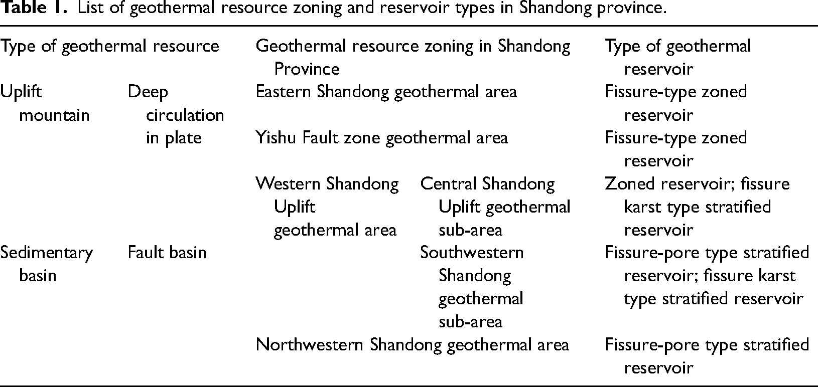
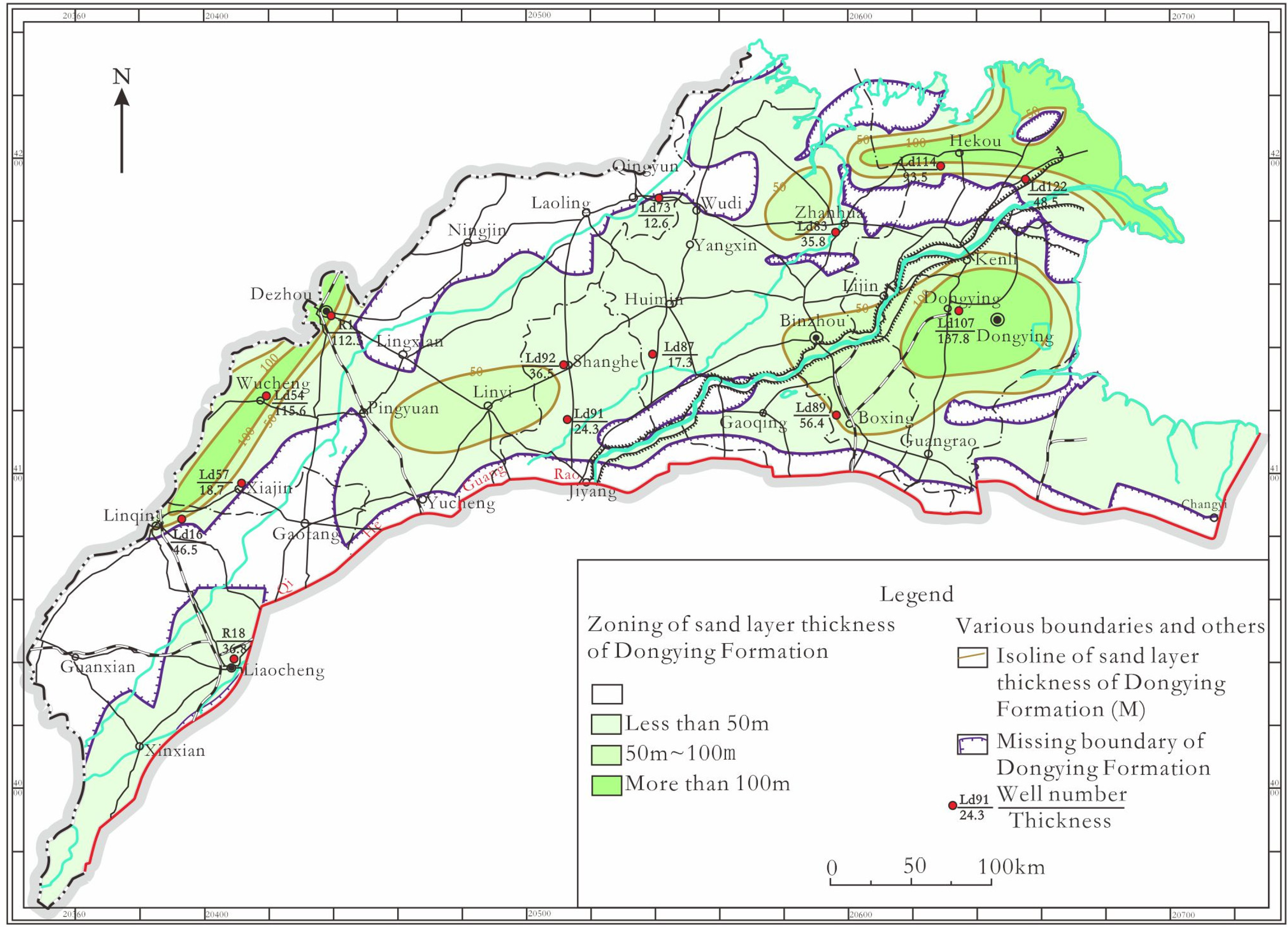
The lithology of the upper member of this formation was observed to be composed of brownish-red and grayish-white gravelly sandstone intercalated with grayish-green mudstone. The lithology of the middle member was purplish-red and gray-greenish mudstone, with grayish white fine sandstone interbedded. The lithology of the lower member of the formation was found to be light gray conglomerate and sandstone, with grayish-green/purplish-red mudstone interbedded. The thicknesses ranged from 200 m to more than 700 m. Four zones were observed with thicknesses greater than 300 m in the Dongying Formation, which was considered to be relatively thick areas. The long axis of the zone was in the direction of NE (Figure 2), while there was only one zone observed with an axis length greater than 700 m, and that area was relatively small.
Thickness zoning of the Dongying formation in northwestern Shandong.
The sandstone contained in the Dongying Formation ranged in thickness from 0 to more than 100 m, and the distribution pattern was found to vary greatly. There were three zones in the formation with thicknesses greater than 100 m, which were roughly distributed in the direction of NE, with an overall small distribution range (Figure 3). Since sandstone is the main lithologic layer for heat storage, water storage, heat conduction, and water bearing, the Dongying Formation was an area of interest in this study.
Sand layer thickness zoning of the Dongying formation in northern Shandong.
The Paleogene Dongying Formation is a type of pore-type reservoir that is known to consist of water-bearing fine sandstone and conglomerate. With the exception of the partial absence in the southeast and uplift areas, the formation was observed to be distributed in all other areas, which mainly included Dongying, Huimin, Zhanhua, Dezhou, Linqing, and other depressions. This study found that under the control of the regional structure and basement undulation, the general distribution law lay in the fact that the thicknesses were the largest in the centers of the depressions and sags, and the smallest thicknesses were located at the edges of the basins. In addition, the distribution was unstable. Therefore, under the control of the basement undulation and regional structure, the general distribution characteristics were as follows: The thicknesses in the centers of the subdepression basins were the largest, reaching 600–700 m; The thicknesses were observed to become thinner toward the edge zones, with a trend of thinning from west to east and from south to north; The development area of the Dongying Formation geothermal reservoirs included the Dongying Depression, Zhanhua Depression, Dezhou Depression, Linqing-Guanxian Depression, and Linyi Depression as the center; The fault structure of the formation was found to be well developed, forming good passageways for the geothermal reservoirs.
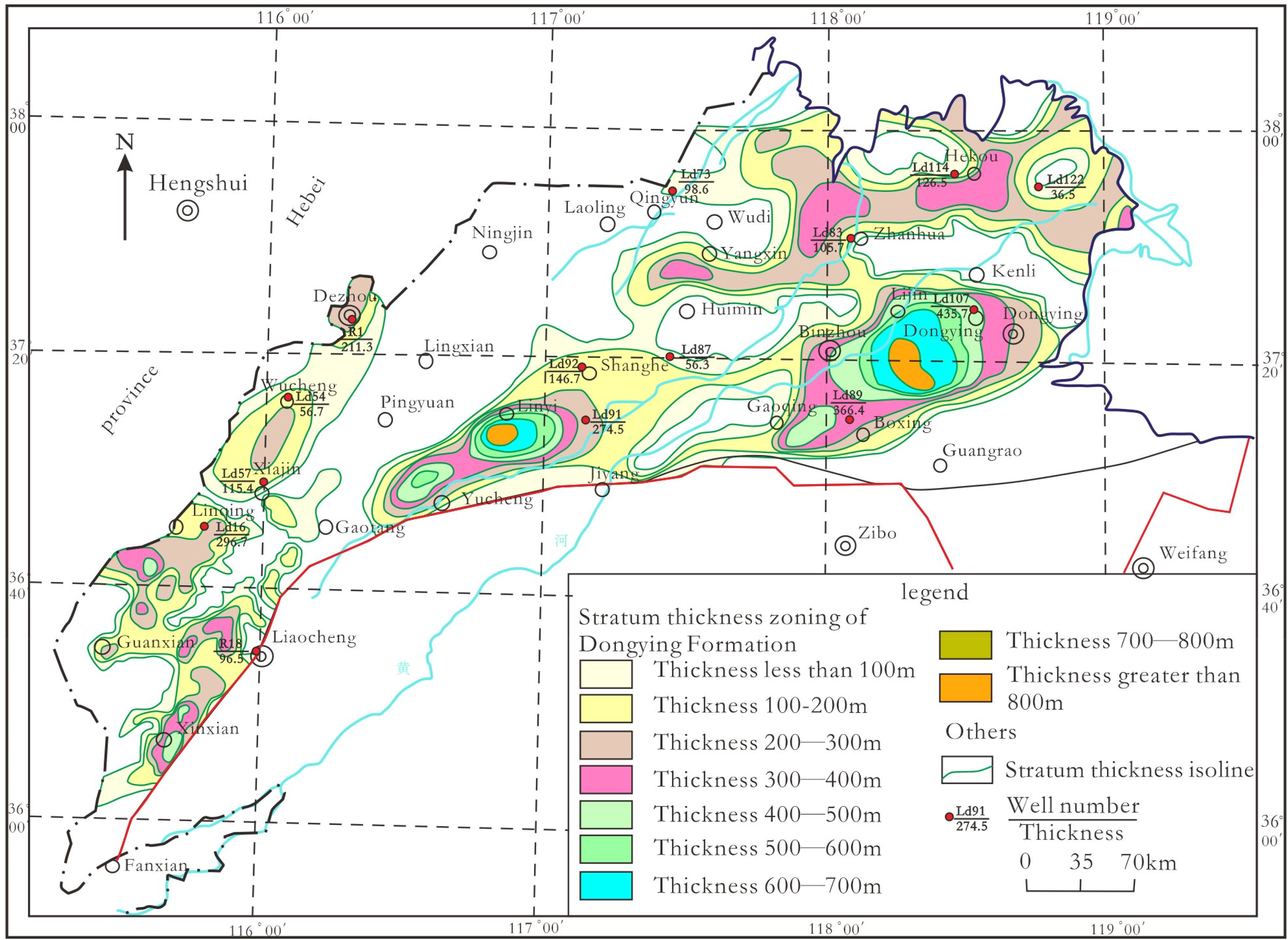
This study found that the general distribution feature of the Dongying Formation was that the sedimentary thicknesses and floor burial depths were deeply controlled by basement undulation and regional structure, in which thickening trends from west to east and from south to north were observed, as detailed in Figure 4. The lithology of the geothermal reservoirs included fine sandstone and conglomerate, with cumulative thicknesses of 0–200 m. The water abundance was found to be high in Dongying and Binzhou, and low in other areas. The wellhead water temperature ranged between 50 and 70 °C, with the majority being warm-water and hot-water type low-temperature geothermal resources.
Burial depth contour of the Dongying formation floor in the geothermal area of northwestern Shandong.
The floor burial depths of the Dongying Formation ranged between 1100 m and more than 2000 m, with the majority generally greater than 1500 m (Figure 4). The overall burial depths were determined to be relatively large.
Neogene Guantao formation (NG)
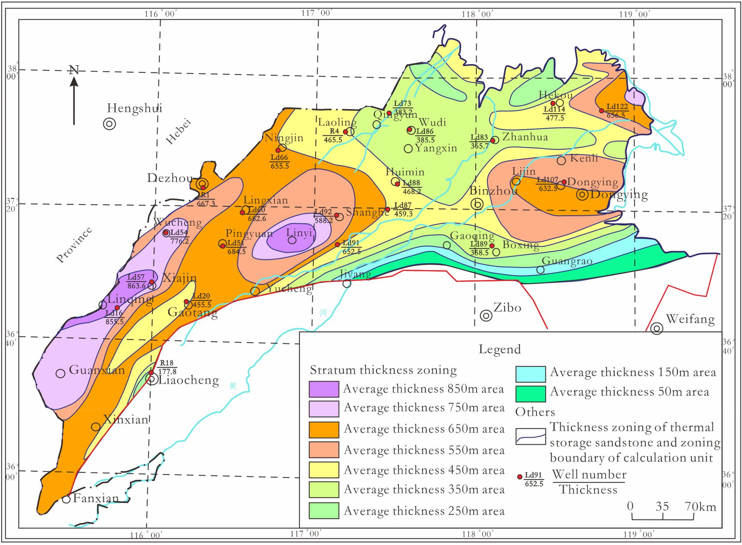
In the Neogene Guantao Formation, the lithology of the upper member was observed to be grayish-white/light-gray fine-to-medium sandstone, brownish-red/grayish-green mudstone, and fine sandstone interbedded with siltstone. The lithology of the lower member was grayish-white/gray medium-to-fine sandstone, medium sandstone, and sandy conglomerate intercalated with brown mudstone. In the vertical direction, the formation displayed the normal cycle sedimentation characteristics of fine in the upper member, and coarse in the lower member. The formation was found to be mainly composed of sandstone and conglomerate, with a relatively coarse lithology, poor sorting, medium roundness, and poor cementation. The thickness of the sandstone accounted for a large proportion of the total thickness of the formation (30–40%). The observed thicknesses of the single layers were generally several meters to more than 10 m, with maximum thicknesses of tens of meters. The bottom of the formation was generally developed with a sandy conglomerate containing quartz and flint. The Neogene Guantao Formation is in unconformable contact with the underlying Paleogene Dongying Formation. It was found that the thicknesses varied greatly, ranging from less than 300 m to more than 700 m, as illustrated in Figure 5. The areas with thicknesses greater than 500 m were distributed in NE-EW direction, and the distribution was relatively limited.
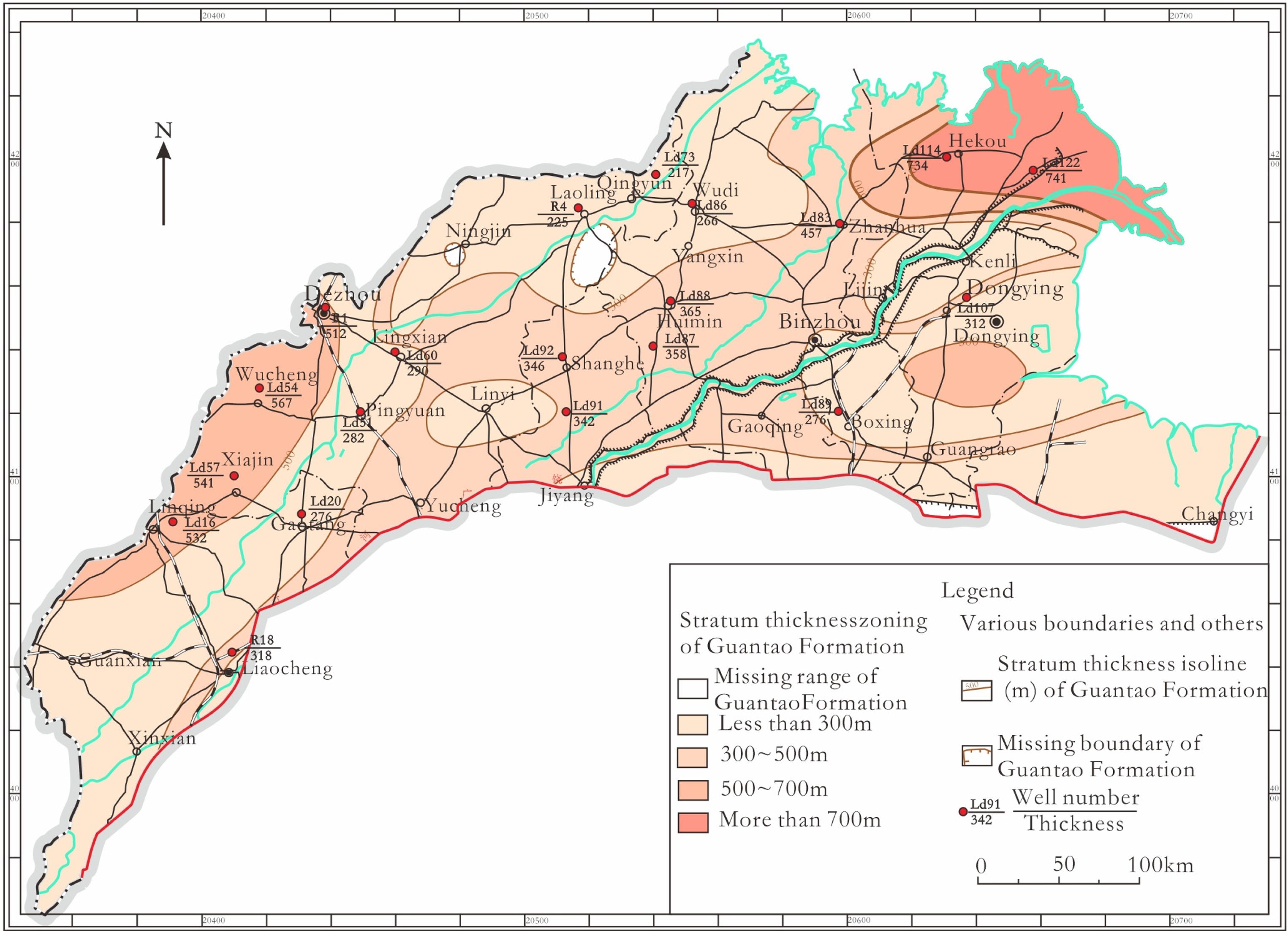
Thickness zoning of the Guantao formation in the northwestern Shandong geothermal area.
The buried floor depths of the Guantao Formation were determined to range from less than 900 m to more than 1700 m, as shown in (Figure 6). However, the floor burial depths were generally greater than 1000 m and up to 1500 m in most areas. The distribution direction was observed to be NE-EW. There were two areas observed with floor burial depths greater than 1700 m, and those were located in the western and northeastern margins, respectively.
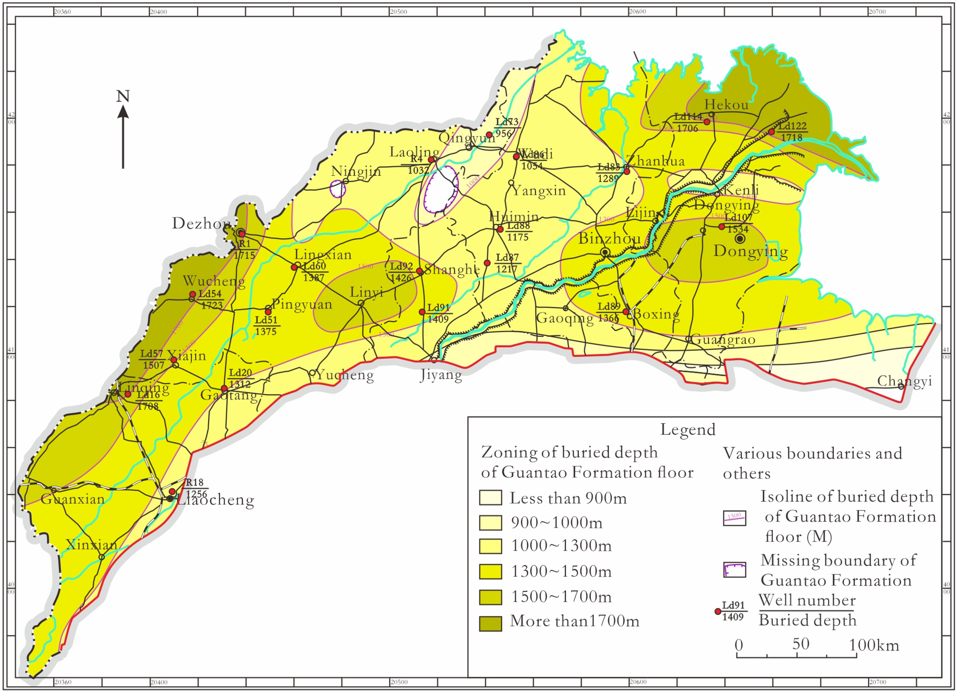
Floor burial depth zoning of the Guantao formation in northwestern Shandong.
The Neogene Guantao Formation has been identified as a type of pore-type reservoir consisting of water-bearing sandstone and conglomerate, which is widely distributed in the study area. It was found that under the control of regional structure and basement undulation, the general distribution law of the formation was that the buried depths of the roof and floor areas changed from shallow to deep from the south to the north, with the thicknesses correspondingly changing from thin to thick. In the uplift area, the reservoir was observed to be shallow and thin, while in the depression area, the reservoir was deep and thick. The buried depths of the roof areas were generally greater than 500 m, with maximum depths in local sections reaching up to 1300 m. The thickness of the geothermal reservoir aquifer ranged from 100 to 200 m, with the average thicknesses of single layers between 10 and 20 m (Figure 7).
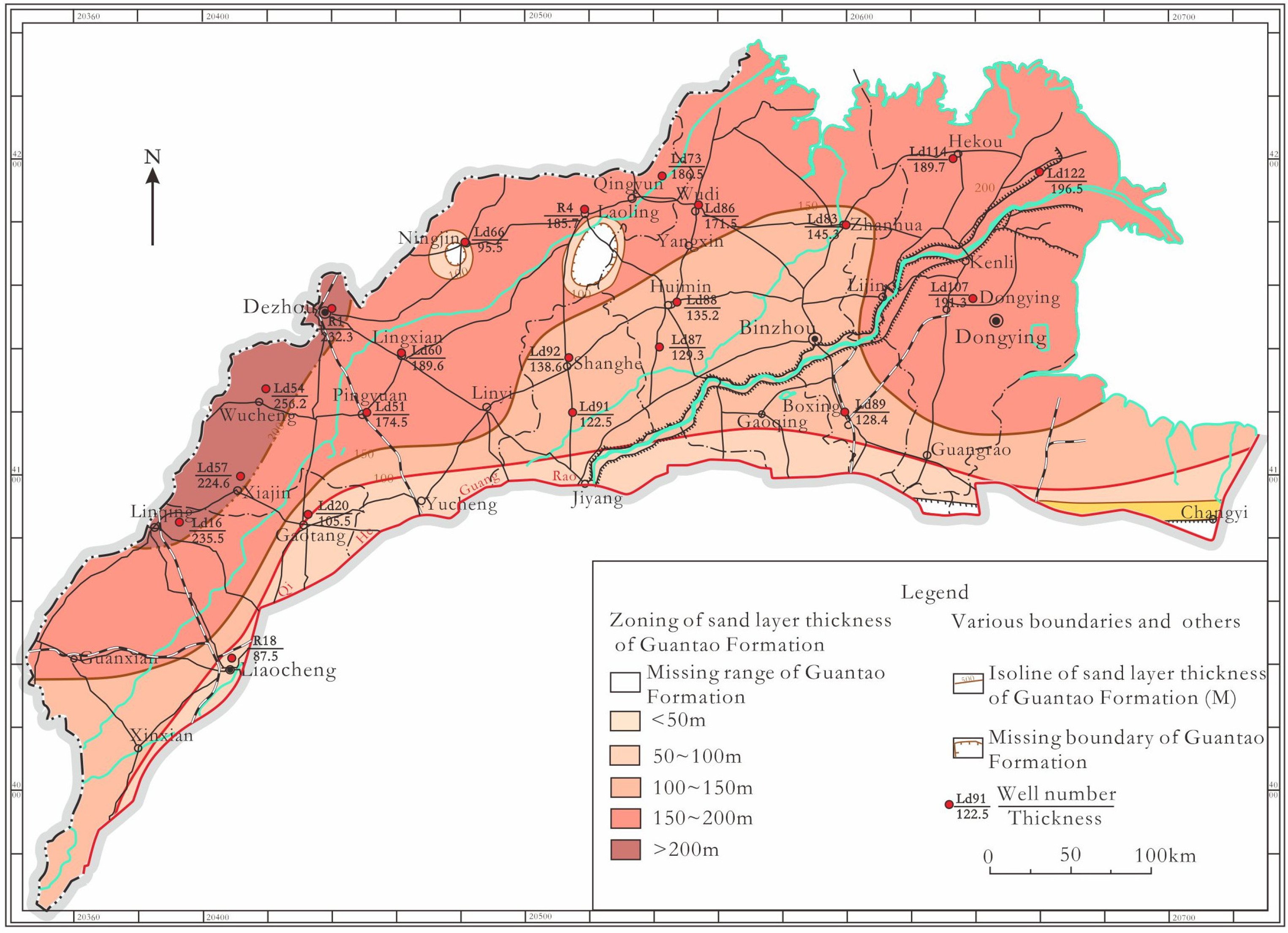
Sandstone thickness zoning of the Guantao Formation in north Shandong.
Neogene Minghuazhen formation (NM)
The lithology of the upper member of the Neogene Minghuazhen Formation was observed to be mainly multicolored sandy clay, sandy mudstone, and mudstone (earthy yellow, brownish red, and brownish yellow), along with grayish-white/light-gray siltstone and fine sandstone locally intercalated with grayish-green mudstone and calcareous nodules. The lithology of the lower member was mainly brownish-red/grayish-green sandy mudstone, mudstone, light-gray/grayish-white fine sand, and medium-fine sandstone locally intercalated with gypsum. It was observed that the mudstone had good diagenesis and was relatively brittle. The sandstone was found to have poor cementation (solidity) and medium sorting and roundness of particles. It was mainly composed of quartz, followed by feldspar. It was observed to be in conformable contact with the underlying Guantao Formation. The thicknesses ranged from 50 m to more than 850 m, with the majority generally greater than 650 m in most areas (Figure 8). The distribution direction was NE-EW, but predominately NE. The buried floor depths of the Minghuazhen Formation ranged between 1125 and 1250 m.
Thickness zoning of the lower Minghuazhen formation in the northwestern Shandong geothermal area.
This study found that the lower member of the Neogene Minghuazhen Formation had the characteristics of a pore-type geothermal reservoir, consisting of water-bearing fine sandstone and medium-fine sandstone. Its distribution law was basically consistent with that of the geothermal reservoir in the upper member of the Minghuazhen Formation. The buried depths of the roof areas were approximately 500 m, and those of the buried floor areas ranged between 500 and 1100 m, with local maximum depths potentially reaching 1300 m. The thicknesses of the geothermal reservoirs generally ranged between 30 and 120 m, as shown in Figure 8. The thicknesses of the geothermal reservoirs in the uplift areas were found to be relatively small, while those in the depression areas were large. The average thickness of the geothermal reservoirs in Linyi, Linqing, and other areas was determined to be 170 m. In addition, the Minghuazhen Formation was also distributed in the area west of the Lankao Fault in Liaocheng, Heze City. The buried floor depths in that location were approximately 1100 m, with an average reservoir thickness of approximately 110 m. The lithology of the geothermal reservoir was composed of loose fine sandstone and medium-fine sandstone, and the water yield of a single well was generally between 40 and 80 m3/h. In the southern piedmont region, the wellhead water temperature generally ranged from 30 to 40 °C, thereby belonging to the warm-water and hot-water type geothermal resources.
Quaternary Pingyuan formation (Q)
The lithology of the upper member of the Quaternary Pingyuan Formation was determined to be mainly yellow/grayish-yellow alluvial silt, silty clay, clay, and silty fine sand. The lithology of the middle member was mainly brownish-yellow/light-grayish-green alluvial/lacustrine facies silty clay, silt, and fine sand. In addition, it was found that the lithology of the lower member was mainly sandy clay intercalated with calcareous nodules. This formation was observed to be in unconformable contact with the underlying Neogene Minghuazhen Formation. The buried floor depths were between 200 and 240 m, and the total thicknesses were between 200 and 240 m. In this study, this formation was also considered to be an effective geothermal caprock in northwestern Shandong.
Formation conditions of the geothermal reservoirs and characteristics of the geothermal reservoir caprocks
Boundary and stratigraphic structure characteristics of the geothermal area in the northwestern Shandong region
The geothermal area of the Western Shandong Uplift was further divided in this study into the geothermal subarea of the Central Shandong Uplift and the geothermal subarea of the Southwestern Shandong Uplift, as detailed in Figure 1. The northwestern Shandong geothermal area and the Southwestern Shandong Uplift geothermal subarea were classified as sedimentary basin conductive geothermal resources. Previous studies had found that the layered and zoned geothermal reservoirs were primarily distributed in sheet shapes, with good regional continuity. The burial, distribution, and geothermal reservoir characteristics of the geothermal resources were found to be mainly controlled by the tectonic units. Therefore, the boundary division of the geothermal fields was mainly determined based on the boundaries of the tectonic units, with the thicknesses of other geothermal reservoirs and the characteristics of the geothermal and chemical fields taken into account.
The boundary of the geothermal block (geothermal field) was determined by comprehensively considering such parameters as the formation thicknesses, sand layer thicknesses, formation temperatures, hydrochemical types, water volume, and burial depths of the floor areas. The geothermal reservoirs mainly included the lower member of the Neogene Minghuazhen Formation, as well as the Guantao Formation and Paleogene Dongying Formation. Meanwhile, the Quaternary and the upper member of the Minghuazhen Formation formed the geothermal reservoir caprock in that area. Taking the Guantao Formation as an example, the characteristics of the geothermal zoning in the northwestern Shandong region were as follows: The temperatures of geothermal reservoirs in most areas ranged from 50 °C to more than 60 °C and were distributed in the western and eastern regions, respectively; The long-axis direction was NE and EW (Figure 9), and the 50 °C zone was small. Therefore, based on the aforementioned findings, it was confirmed that the geothermal resources in the northwestern Shandong region were relatively abundant.
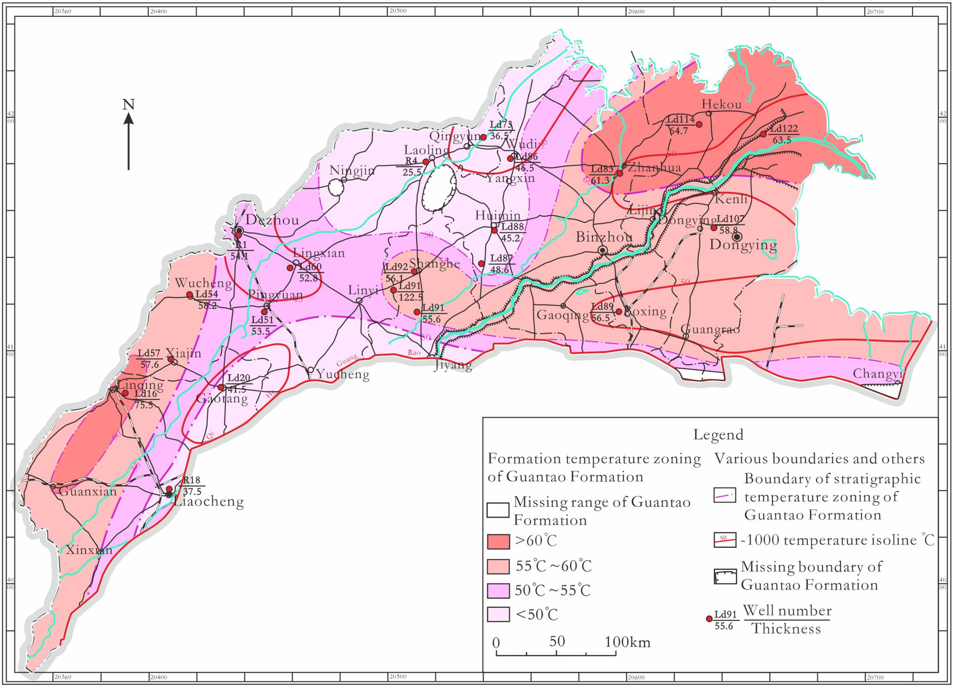
Temperature zoning of the Guantao formation in the northwestern Shandong region.
The Guantao Formation, Minghuazhen Formation, and Dongying Formation in the northwestern Shandong region are thick-layered, interbedded, and zoned stratigraphic structures. The three formations feature the prominent macroscopic stratigraphic characteristics of geothermal reservoirs and caprocks. Therefore, it was indicated that there was a spatial control relationship between the geothermal reservoirs and caprocks in the region. The geothermal reservoirs were mainly distributed in a zonal manner on the bedding plane, with good regional continuity, as shown in Figs. 2, 3, 5, 8, and 9.
Geothermal source types in the northwestern Shandong region
This study selected the Archean metamorphic rock series as the basement. It was found that a set of Lower Paleozoic (mainly composed of marine carbonate rock) and Upper Paleozoic (mainly composed of marine and continental alternating facies to continental facies) were developed in the geothermal areas of northwestern Shandong, as well as Mesozoic composed of continental sediment. The tectonic units were composed of the Jiyang Depression and Linqing Depression, and each uplift and depression was composed of a series of secondary uplifts and depressions. It was interesting to note that due to the large burial depths of the Moho surface in that geothermal area, it had a high heat flow and a strong water-bearing layer. Therefore, it was considered to be the area with the greatest potential for geothermal resource development in Shandong Province.
As can be seen in Figure 10, the geothermal area of northwestern Shandong was divided into the following geothermal fields: Chezhen-Zhanhua Depression geothermal field; Dongying Depression geothermal field; Huimin Depression geothermal field; Linyi Depression geothermal field; Dezhou Depression geothermal field; Linqing-Guanxian Sub-depression geothermal field; Shenxian Depression geothermal field; Shouguang-Weibei geothermal field; Wudi-Ningjin Depression geothermal field; Zouping-Zhoucun geothermal field; Yanggu Uplift geothermal field; Taishan-Yishan Uplift geothermal field and the Chengzi-Ningjin Sub-depression geothermal field. Therefore, the northwestern Shandong region was classified as a sedimentary basin conductive geothermal resource area.
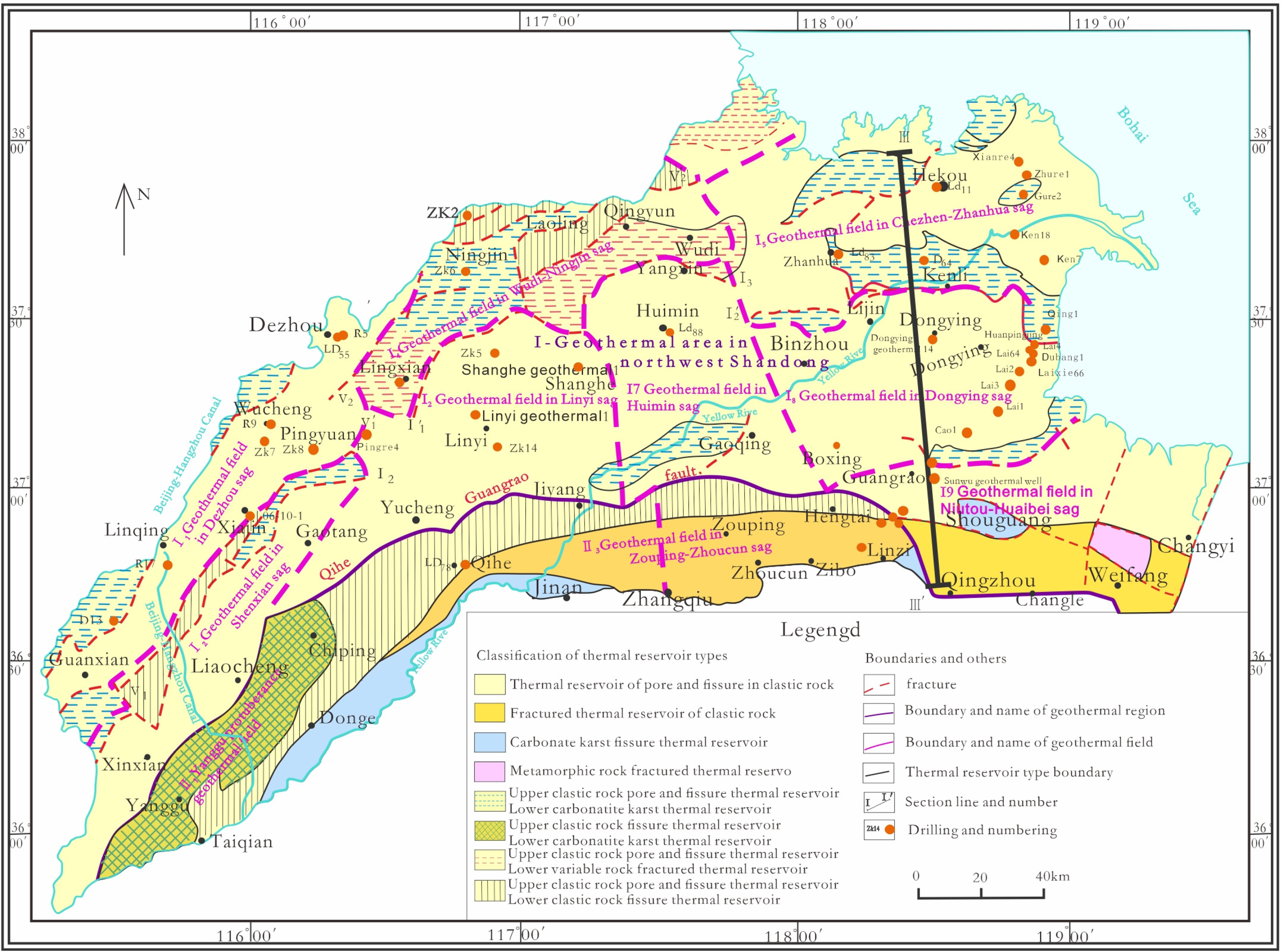
Geothermal field division in the northwestern Shandong region.
The thickness of the geothermal reservoir in the Taishan-Yishan Uplift was determined to be less than 100 m. The thickness of geothermal reservoir in the Chengzi-Ningjin Uplift was 100–200 m. It was found that the thicknesses of the geothermal reservoirs in the uplifts ranged between 100 and 150 m. The thicknesses of the geothermal reservoirs in the depressions were generally greater than 150 m, with maximum thicknesses observed in the Dezhou Depression, Linqing-Guanxian Depression, and Zhanhua Depression in the west (more than 200 m in the central zone), followed by the Dongying Depression (150–200 m). The minimum thicknesses were observed in the Linyi Depression and the Huimin Depression (100–150 m). It was determined that the average geothermal reservoir thickness of the Guantao Formation in the west part of the Liaocheng-Lankao Fault in Heze City was approximately 180 m.
The geothermal reservoirs in the northwestern Shandong geothermal area mainly occurred in a layered manner. Such reservoirs were composed of strata with large distribution areas, effective porosity, and high permeability, which were dominated by heat conduction. The ground temperatures were found to be uniform relative to other geothermal areas. In addition, based on the distribution patterns of the temperature gradients in the area and an average gradient of 3.5 °C/100 m, it was revealed that the temperatures at depths below 350 m were greater than 25 °C. The heat sources mainly originated from the normal deep crust, upper mantle conductive heat flow, and deep magma heat. In addition to the sedimentary water and stored water preserved during the formation of the basin sediment, the geothermal water was determined to be mainly supplied by atmospheric precipitation in the far and near mountains during the long geological period after the formation of the sediment. This study's results revealed that within the depth range of 3000 m, the main geothermal reservoirs in the area included the following: The pore-type geothermal reservoir in the lower member of the Neogene Minghuazhen Formation; pore-fissure geothermal reservoir in the Neogene Guantao Formation; pore-fissure geothermal reservoir in the Paleogene Dongying Formation (Figure 10); pore-fissure geothermal reservoir in the Paleogene Shahejie Formation; and a Cambrian-Ordovician carbonate rock karst fissure geothermal reservoir.
In accordance with the characteristics of the water-bearing medium of the geothermal reservoirs and the development degrees of the pores, fractures, and karst, the layered geothermal reservoirs were divided into fracture-pore type layered geothermal reservoirs and fissure-karst type layered geothermal reservoirs. The reservoirs were widely distributed in the geothermal area of the Northwestern Shandong Depression, as well as the geothermal area of the West Shandong Uplift, northern edge of the Central Shandong Uplift and the periphery of the Southwestern Shandong Uplift geothermal subarea. This study found that the geothermal reservoirs in the Northwestern Shandong Depression geothermal area displayed the characteristics of Paleogene and Neogene multilayer superposition, and the lower layer temperatures were higher than the upper layer temperatures.
Geothermal reservoir caprock in the northwestern Shandong region
Based on the above analysis results, it was concluded that the major geothermal reservoirs in the region included the lower member of the Neogene Minghuazhen Formation and the Guantao and Dongying Formations. The Quaternary argillaceous sediment and mudstone in the upper member of the Minghuazhen Formation formed the caprocks in the study area.
The geothermal reservoir caprock in the lower member of the Minghuazhen Formation is the upper member of the Minghuazhen Formation and the loose sedimentary layer of the Quaternary Pingyuan Formation. The lithology includes soft layers composed of cohesive soil and sandy soil, which are characterized by low-density levels, large thicknesses, poor thermal conductivity, and high resistance. Those characteristics are considered favorable for good natural geothermal reservoir caprock. The geothermal reservoir caprock of the Guantao Formation was determined to be the Minghuazhen Formation and the Quaternary loose sedimentary layers, and the geothermal reservoir caprock of the Dongying Formation was confirmed to be the Neogene and Quaternary loose sedimentary layers, as detailed in Figure 11.
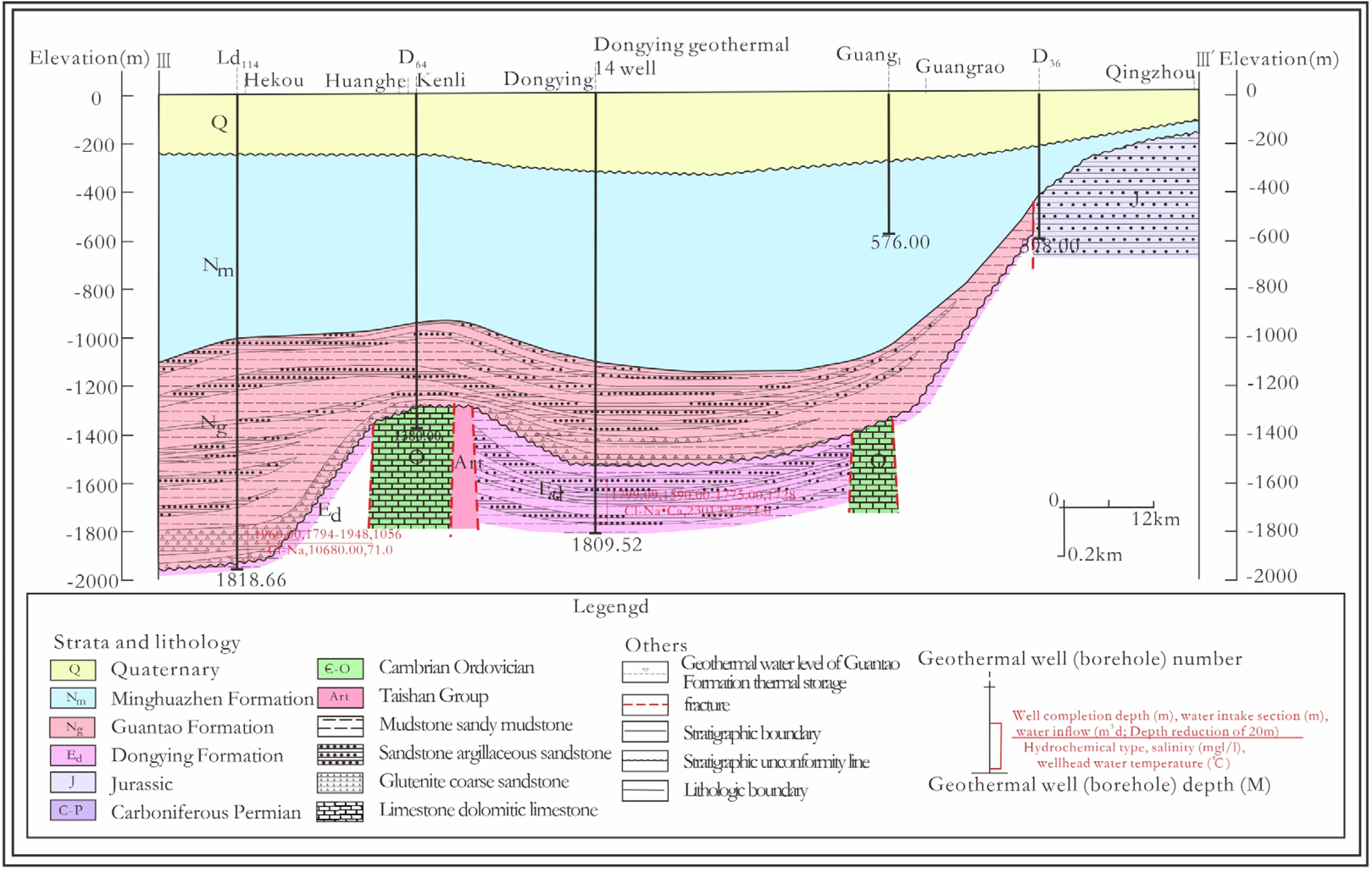
Geothermal geological profile of the geothermal field in the Dongying depression.
Conclusions
In this study, the northwestern Shandong region was taken as the anatomical point. The tectonic setting of the study area, particularly the genetic relationships between the stratigraphic textures, formation thicknesses, burial depths, and the occurrences of geothermal resources, were analyzed in depth from a macro perspective. The following conclusions were obtained:
The major geothermal reservoirs in the northwestern Shandong region included the lower member of the Neogene Minghuazhen Formation and the Guantao Formation. Meanwhile, the Quaternary argillaceous sediment and mudstone in the upper member of the Minghuazhen Formation formed the geothermal reservoir caprocks in the study area. By taking the boundary between sag basin and the uplifting area as the dividing line of the geothermal fields, the geothermal areas in the northwestern Shandong region were divided into different geothermal fields, all belonging to the sedimentary basin conductive geothermal resources. The layered and zoned geothermal reservoirs of the northwestern Shandong region were observed to be primarily distributed in sheet shapes, with good regional continuity. The burial depths, distribution patterns, and geothermal reservoir characteristics of the geothermal resources were determined to be mainly controlled by the tectonic units.
Footnotes
Declaration of conflicting interests
The author(s) declared no potential conflicts of interest with respect to the research, authorship, and/or publication of this article.
Funding
The author(s) disclosed receipt of the following financial support for the research, authorship, and/or publication of this article: This work was supported by the Reversal Mechanism of Peat Formation and Burial Process on Climate in Large Coal-forming Basin, (grant number 42272205).