
Abstract
Exploration of the geothermal resources in the Beijing–Tianjin–Hebei region has been kept for tens of years, and the recent success of geothermal exploration in the Xiongxian County provides a new model for the utilization of geothermal resources in this area. This research integrates the formation of temperature obtained from hydrocarbon drilling, experiments of reservoirs’ micro-characteristics and physical property, and employs the previous works on the regional geological settings to investigate the geothermal reservoirs and geothermal status. The microphotography indicates that the reservoir space is dominated by supergene karst in the Wumishan Formation which is mainly controlled by the topography when the interval emerged. The groundwater in the Pre-Paleogene has the similar composition of the hydrogen and oxygen isotope with the atmospheric precipitation, and the salinity of the groundwater has an increasing trend from the Taihang Mountain and the Yanshan Mountain to the depocenters, which indicates the groundwater originates from the atmospheric precipitation of the Taihang Mountain and the Yanshan Mountain and transports to the depocenters. The thermal conductivity of the lower carbonate rocks is much higher than the upper clastic intervals. This difference makes the upper clastic intervals of the Paleogene and the Neogene good seals for geothermal reservoirs and leads to the regional anomaly of the terrestrial heat flow: the intrabasin highs have a thicker thickness of the Pre-Paleogene carbonate deposition with high thermal conductivity, which results in high efficient thermal transmission and high terrestrial heat flow. Consequently, this research suggests that the intrabasin highs and slopes are the favourable areas for geothermal exploration with reservoirs of good quality, high terrestrial heat flow and efficient groundwater supply, and several areas were selected to be the potential targets for the Wumishan Formation and the Pre-Paleogene.
Keywords
Introduction
The demand for clean energy is increasingly pressing, because the traditional fossil fuels (coal and oil) are finite resources and lead to many environmental problems. For these reasons, hydro-, solar and wind energies have already been used widely, and geothermal resources also focus minds (Bertani, 2005; Bilgen et al., 2008; Lund et al., 2005). Geothermal resources have been used in industry, domestic heating, agriculture and so on (Barbier, 2002; Brophy, 1997; Rybach, 2003), and the annual geothermal yield of China keeps No. 1 in the world. The recent success of geothermal exploration and development in the Xiongxian County led by the SINOPEC, which is in the Beijing–Tianjin–Hebei region (BTH region), provides an opportunity to solute the energy and environment problems in the BTH region, and constructs a thermal development mode in oil and gas exploitation area.
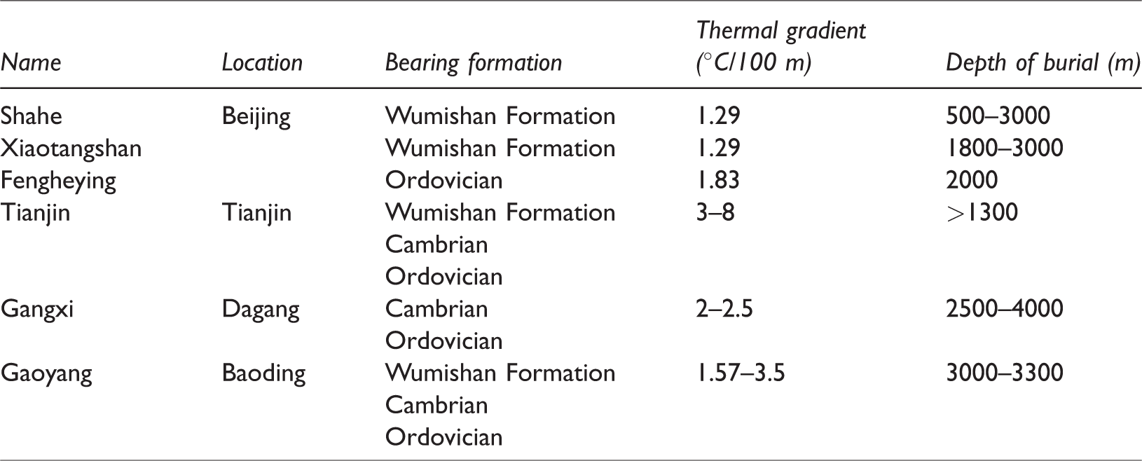
Several geothermal fields have been developed for years in the BTH region, and most of them are not related to the hydrocarbon drilling. Table 1 shows the detailed information about some representative geothermal fields (Pan and Wang, 1999; Yan and Yu, 2000). It indicates that the Wumishan Formation of the Middle-Upper Proterozoic, Cambrian and Ordovician are the main bearing formations for geothermal exploration, and the thermal gradient ranges from 8°C/100 m to 1.29°C/100 m. In the previous exploration of geothermal resources, the hydrocarbon drilling data and seismic data of the adjacent oil field were not utilized, although there are four large oil fields (the Huabei Oil Field, the Jidong Oil Field, the Dagang Oil Field and the Zhongyuan Oil Field) in the BTH region and all these oil fields have a high degree of exploration and have thousands of wells, high-quality three-dimensional seismic data and experimental test data. In addition, the exploration of these geothermal fields is isolated, and the regional geothermal features are not clear, which blocks the further utilization of the geothermal resources in the BTH region.
Key information about the representative geothermal fields in the Beijng–Tianjin–Hebei region.
This research integrates the geological data collected from these oil fields to investigate the regional structural features and geothermal status including terrestrial heat flow (HF) and geothermal gradient. As one of the main bearing formation, the Wumishan Formation, the Middle-Upper Proterozoic was selected to be the study interval to reveal the characteristic of the geothermal reservoirs. Our study tries to give a regional understanding of the geothermal structure and geothermal status, and investigates the regularity of geothermal resources accumulation, which will be an important guideline for the further exploration of geothermal resources in the BTH region.
Geological settings
The BTH region is located in the east and covers most areas of the North China craton, and it is mainly consisted of Beijing, Tianjin and Hebei provinces (Figure 1). The tectonic evolution of the study area experiences the stage of crystallization of basement (4000 Ma–1950 Ma), the stage of craton (1950 Ma–248 Ma), folding (248 Ma–65 Ma), rifting (65 Ma–22 Ma) and depression (22 Ma–2.6 Ma) (Figure 2).
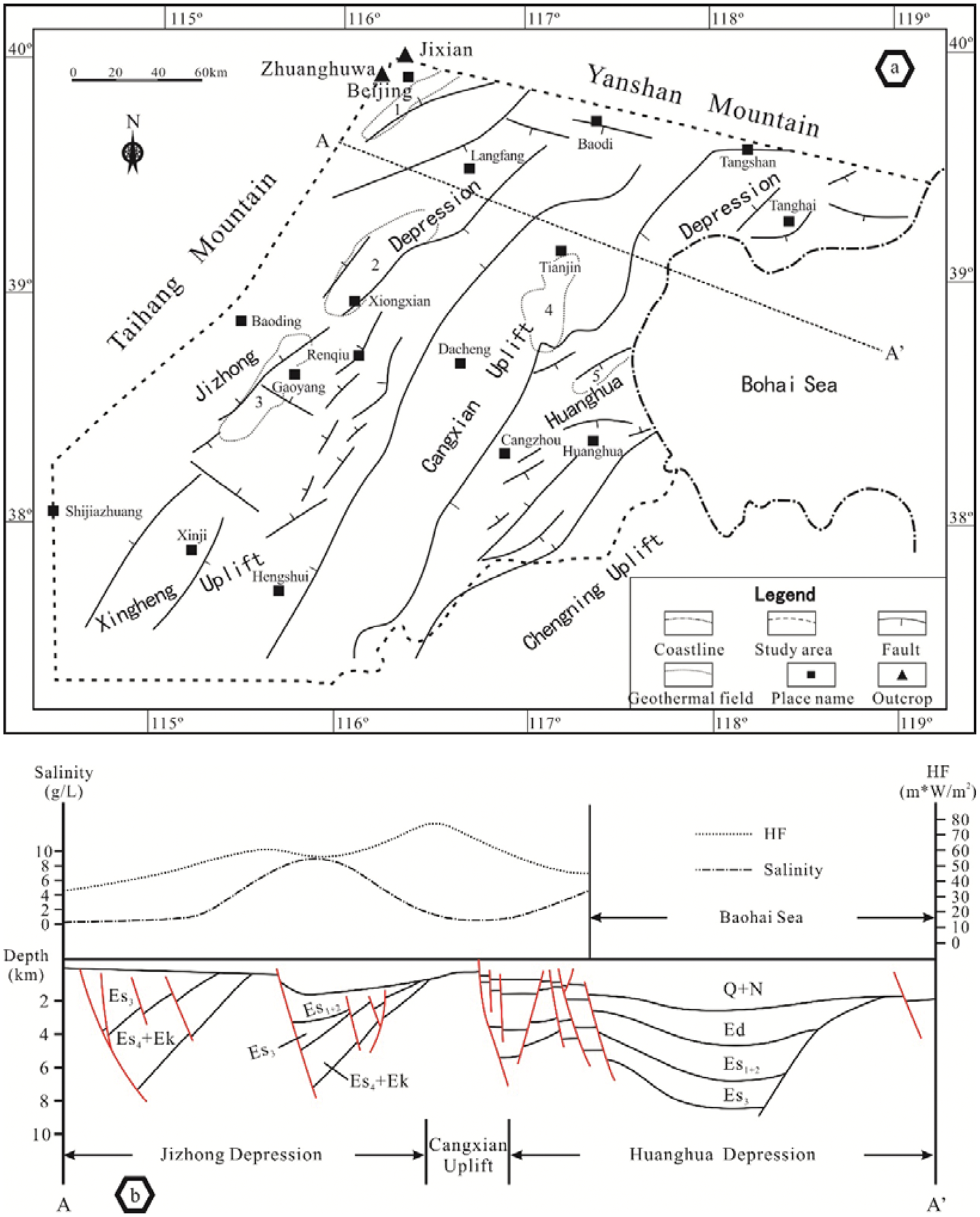
Regional structural map (a) showing the major faults and structure involving Jidong Depression, Xingcheng Uplift, Cangxian Uplift, Huanghua Depression and Chengning Uplift. The Beijing, Xiongxian, Gaoyang, Tianjin and Gangxi geothermal fields also shown in the map and labelled by 1, 2, 3, 4 and 5, respectively. The dotted line AA′ showing the location of the regional structural profile. The regional structural profile (b) showing the major structures (modified from Feng et al., 2010) and variation of the salinity and the HF.
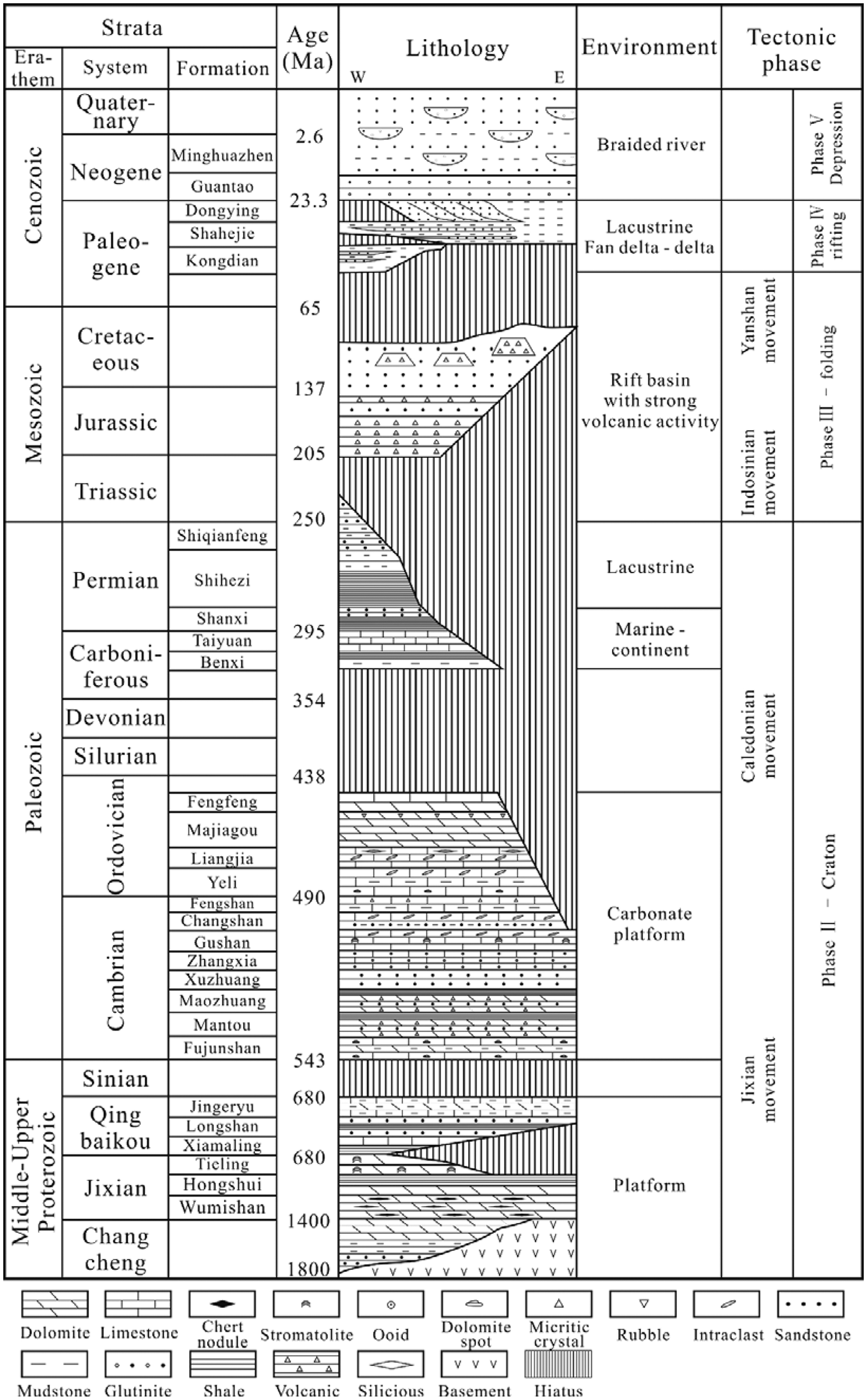
The stratigraphic histogram showing the stratigraphy framework, the lithology, depositional environments and tectonic events.
The first phase of the tectonic evolution corresponds to the Fuping movement. During this phase, the continental nucleus formed with strong folding and migmatization. The second phase consisted of the Changcheng System, Jixian System, Qingbaikou System, the Cambrian and the Ordovician. During the expansion period in the early Middle Proterozoic, a huge NE-trend rift valley, was filled by the Changcheng System (1800 Ma–1400 Ma) with clastic rock depositing in the bottom and dolomite in the upper in phase with strong uplifting and subsiding (Ji et al., 2001). The Changcheng System is closed by a regional unconformity (Ji et al., 2001). The following relatively weaker extension results in thousand meters of marine dolomite and calcite dolomite deposition of the Jixian System (14 Ma–10 Ma) (Duan et al., 2002), and the study interval, the Wumishan Formation, is the thickest interval with the 3400 m deposition of chert dolomite. The previous study on the geochemistry of the Jixian System suggests a tidal flat environment in this system (Zhao, 1995). The depositional thickness of the Qingbaikou System (10 Ma–8 Ma) is much thinner than the lower two systems with the thickness of 400 m. The lithology of the Qingbaikou System is dominated by limestone (Xiamaling Formation, 120–200 m), quartz sandstone (Longshan Formation, 100 m), argillaceous limestone and dolomite (Jing’eryu Formation, 100 m) from the bottom to the top. During the deposition of the Jing’eryu Formation, the topography in this area turned to be flat, and the depositional environment ranges slightly (Duan et al., 2002). This system was ended by the Jixian movement which results in a regional unconformity lasting for about 137 Ma and a gentle platform (Duan et al., 2002; Liu et al., 1999). The thousand meter thickness of limestone and dolomite Cambrian deposits lay on the unconformity with depositional environment changing from tidal flat to platform (Hao et al., 2014; Liu et al., 1999). The depositional figures of the Early Ordovician succeed that of the Cambrian, and the most east part of the North China (corresponding to the study area) emerged, and the west part is dominated by platform environment (Chen et al., 2015). The long-term transgression in the Middle Ordovician results in large area of epicontinental sea in the east and platform in the west (Chen et al., 2015). In the Late Ordovician, the Caledonian movement led to uplift and the sea water out of the study area, and only a few areas in the middle North China were covered by platform deposition (Hao et al., 2014). This movement also lead to the missing of the Silurian and the Devonian and long-term weathering of the top of the Ordovician in the study area, and ceased until the Middle Carboniferous (Yu et al., 2005). Marine and continental coal-bearing strata deposited alternatively from the Middle Carboniferous to the Permian (Duan et al., 2002; Liu et al., 1999; Yu et al., 2005).
The third phase corresponds to the Indo-China movement and Yanshan movement. These movements cause strong folding in the whole North China (Wu et al., 2007). The study area emerged, and the west part of the North China was filled by clastic sediments during the Trias and the Early Jurassic (Hao et al., 2014). From the Middle Jurassic to the Late Cretaceous, the study area is characterized by rift basin with volcanism (Hao et al., 2014; Yu et al., 2005).
The fourth phase is the synrift stage (Paleogene), with the same as the evolution history of the Bohai Bay Basin. A series of NE- or NEE-directed rift basins and uplifts/salients (Feng et al., 2010). These rift basins were filled by thousand meters of continental clastic strata and were dominated by lacustrine, deltas and alluvial fan environments (Feng et al., 2010). The study area involves three NE-directed and parallel structural units, the Jizhong Depression, the Cangxian Uplift and the Huanghua Depression, which is bounded by Taihang Mountain in the west and Shaleitian Salient in the east (Figure 1(a)), and in which the main faults dip to the east (Figure 1(b)). The regional structural framework and the top structure of Pre-Paleogene was established during this phase, and Figure 3 shows the formation distribution of the top of the Pre-Paleogene. The Wumishan Formation covers most area of the north-west part of the BTH region, and the Carboniferous to the Permian and the Jurassic–Cretaceous covers the middle and east parts of the BTH region, respectively. The subsidence of the fifth phase turned down, and the depositional facies are figured by alluvial, fluvial and lacustrine deltas.
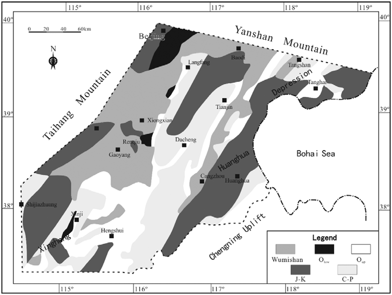
Geologic map the Pre-Paleogene.
Data and method
Geothermal reservoirs
Samples of the Wumishan Formation collected from outcrops and cores of hydrocarbon drilling wells were used to conduct the thin section and casting thin section analyses. The microphotography captured by Leica DM4500P polarizing microscope and outcrop observation was used to investigate the features of the Wumishan Formation involving lithology and pores. The outcrops observed in this study are shown in Figure 1(a).
Groundwater
Three hundred and sixty-nine groundwater samples of the Middle-Upper Proterozoic were collected from the hydrocarbon drilling wells, which were used to reveal the ionic composition and measure the salinity. One hundred and twelve samples of terrestrial cold water and 67 samples of groundwater were obtained to do the hydrogen and oxygen isotope analyses. The salinity is an important parameter to identify the groundwater circulation, and the distribution of groundwater salinity in the planar view indicates the trend of groundwater migration. The results of hydrogen and oxygen isotope analyses are usually employed to draw cross plot to compare with that of atmospheric precipitation, which can be used to identify the source of the groundwater supply (Barragán et al., 2005; Pastorelli et al., 2001).
Geothermal gradient and terrestrial HF
The observational formation temperature is tested in the hydrocarbon drilling wells. Most of the temperature data are tested after several months or years since the well completion. Therefore, the temperature obtained is stable, and the results are reasonable. The terrestrial HF is a parameter that used for considering the signal of thermal conductivity of rocks and geothermal gradient, and the terrestrial HF is usually expressed as the product of the thermal conductivity and geothermal gradient. The geothermal gradient is obtained from measurement value in the hydrocarbon drilling wells, and the difficulty is the estimation of thermal conductivity of rocks, because this parameter ranges widely from different lithology, and even though the same lithology may range a lot since a variation of mineral content. For thermal conductivity, core samples gathered from Jizhong Depression were used for testing the thermal conductivity. The thermal conductivity of dolomite and limestone is 7.14 ± 1.2 W/mK and 3.16 ± 1.94 W/mK, respectively. The clastic rock of the Upper Paleozoic is about 2.6 W/mK and that of the Cenozoic is 1.8 W/mK. The average thermal conductivity (K) is expressed as the following equation

An unpublished inner report obtained from the China Petroleum & Chemical Corporation was employed to provide a regional overview of the geothermal gradient and terrestrial HF.
Results
Geothermal reservoirs
Since the Wumishan Formation is the representative geothermal reservoir in the developed geothermal fields, this paper studied the lithology and reservoir space of the Wumishan Formation. This interval has experienced several times of long-term weathering induced by tectonic uplift and it is also an important hydrocarbon reservoir in the Jizhong Depression.
Lithology
The Wumishan Formation is divided into four members in the previous works, and the key profile of this formation emerges in the Jixian County, Tianjin City, which preserves the most depositional record and was observed and logged the lithology to construct the lithology framework (Figure 4).
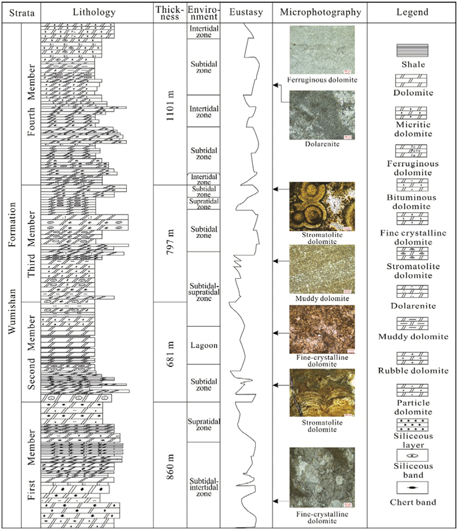
Lithology histogram showing the lithology, the eustasy, environments and the microphotography of the Jixian outcrop section.
The first member, the bottom of the Wumishan Formation, records a process of sea level fall. The lower part is figured by the interbed of grey or dark grey coarse to fine crystalline dolomite containing chert nodules and bands and grey silicolite, the silty or muddy dolomite encounters occasionally. The muddy fine crystalline dolomite is dominated by massive or banded chert in the upper part of the first member, and the wavemark and desiccation crack can be observed, which indicates an environment of intertidal zone and supratidal zone.
The second member is characterized by stromatolitic dolomite. The bottom of this member records frequent environmental variation between subtidal zone and supratidal zone. The subtidal zone deposition is figured by dark grey moundy and wavy stromatolitic dolomite, which indicates a relatively high energy environment. The shape of the stromatolitic dolomite in the intertidal zone is figure by stratiform and moundy, which indicates a relatively low-energy environment. In the supratidal zone, the lithology is dominated by thin layer of grey dolomite or grey-green dolomitic shale. The depositional environment changed to lagoon in the middle part, of which the lithology is characterized by interbed of grey-green shale and shallow grey fine crystalline algal dolomite. The upper part of this member is occupied by middle crystalline dolomite, green shale and siliceous-banded dolomite. Breccia dolomite is observed in the top of this member.
The sea level rose dramatically in the third member. The lithology in the lower part is the composition of stromatolitic dolomite, siliceous-banded dolomite and fine crystalline dolomite, and carmine muddy dolomite can be observed, which indicates a shallow or exposed environment. The coniform, columnar and moundy stromatolitic dolomite, oncolite with the muddy crystalline dolomite deposition, indicate a continuous sea level rising.
The lithology of the fourth member consisted of stromatolitic dolomite and fine to muddy crystalline dolomite with sea level fluctuating slightly.
Reservoir space
The original pores in the Wumishan Formation are rare, since the lithology of this formation is algae – or evaporation – related and suffered strong dolomitization. The original pores are observed in the grain dolomite in this study and were filled by cementation (Figure 5(a)). Most pores observed in this study are mainly generated by quasi syngenetic dissolution and karstification.
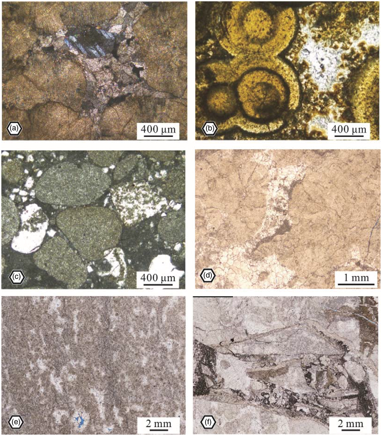
Micro-characteristics of the geothermal reservoir of the Wumishan Formation. (a) Oolitic dolomite showing the original pores cemented by sparry calcite, Jixian outcrop section, cross-polarized light; (b) Oolitic dolomite showing the dissolution of the early fibroid calcite cementation, Jixian outcrop section, plane-polarized light; (c) Algal dolomite showing the selective dissolution, Jixian outcrop section, plane-polarized light; (d) Algal dolomite showing the geopetal structure, Zhuanghuwa outcrop section, plane-polarized light; (e) Algal dolomite showing the non – selective dissolution and the pores were cemented by sparry calcite, Zhuanghuwa outcrop section, plane-polarized light; (f) brecciated dolomite showing the karst cave filled by brecciated dolomite.
The quasi syngenetic dissolution occurs in the diagenetic environment of atmospheric fresh water and is generally caused by temporal sea level fall, and the dissolution by atmospheric fresh water happens in the minerals that is relatively easier to be dissolved (Zhen-Hong and Zheng, 2004; Zhang and Liu, 2009). Figure 5(b) shows that the early fibroid calcite cementation is dissolved, and the grains keep reserved, which indicates the selective dissolution of the more dissolvable cementation. The pores shown in the Figure 5(c) resulted from the dissolution of the more dissolvable grains, which is also selective dissolution. Another type of quasi syngenetic dissolution does not have selectivity (Figure 5(e)). Figure 5(d) shows the geopetal structure in fine crystalline dolomite. The pores were filled by micrite calcite in the bottom and sparry calcite in the top. The development of the quasi syngenetic dissolution is controlled by climate, depositional facies and sea level fluctuation, and it is complex to be predicted accurately and reasonably.
Supergene karst developed not only in the Wumishan Formation but also in all the Pre-Paleogene strata. The regional or local uplift caused by the multiple tectogenesis results in large-scale supergene karst near the top of the Pre-Paleogene and also in the intervals under the other regional unconformity. The vertical sequence of the supergene karst in the Wumishan Formation was identified from the hydrocarbon drilling wells in the Jizhong Depression which involves vadose zones and phreatic zones. The vadose zone is figured by perpendicular dissolved pores and fractures, but this space has high potential to be filled by sandy sediments or brecciated dolomite (Figure 5(f)).
The previous research about the geothermal field documents the cross section that shows the structural figures and the location of hot water accumulation (Figure 6) (Pan and Wang, 1999; Yan and Yu, 2000). The geothermal resources in the Wumishan Formation are obtained in the Pre-Paleogene highs in phase with unconformity.
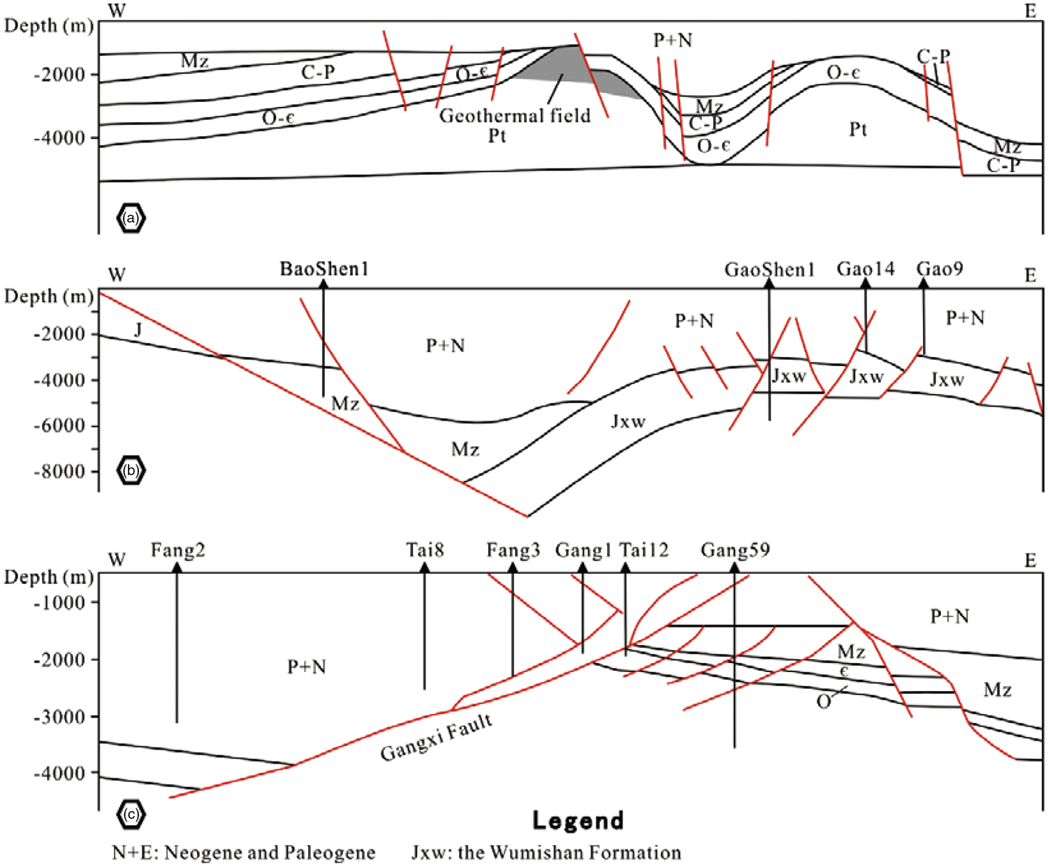
Structural profiles of the Tianjin geothermal field (a), the Gaoyang geothermal field (b) and the Gangxi geothermal field (c), which show the location of the geothermal field (Pan and Wang, 1999; Yan and Yu, 2000).
Groundwater
Ionic composition
The results of the ionic analysis were projected in piper diagram (Figure 7). The result points locate in the lower right in triangular chart of basic ion, which indicates a high content of K+ and Na+. The percentage content of Ca2+ and Mg2+ ranges from 0% to 20%, and that of the K+ and Na+ is much higher and ranges from 80% to 90%. The anion composition is figured by high content of Cl– of which the percentage content is over 50%–90%. The content of the SO42–, and the HCO3– and CO32– ranges from 0%–20% and 0%–60%, respectively. Based on these results, it can be concluded that the hydrochemical facie of the Middle-Upper Proterozoic is dominated by the sodium chloride type.
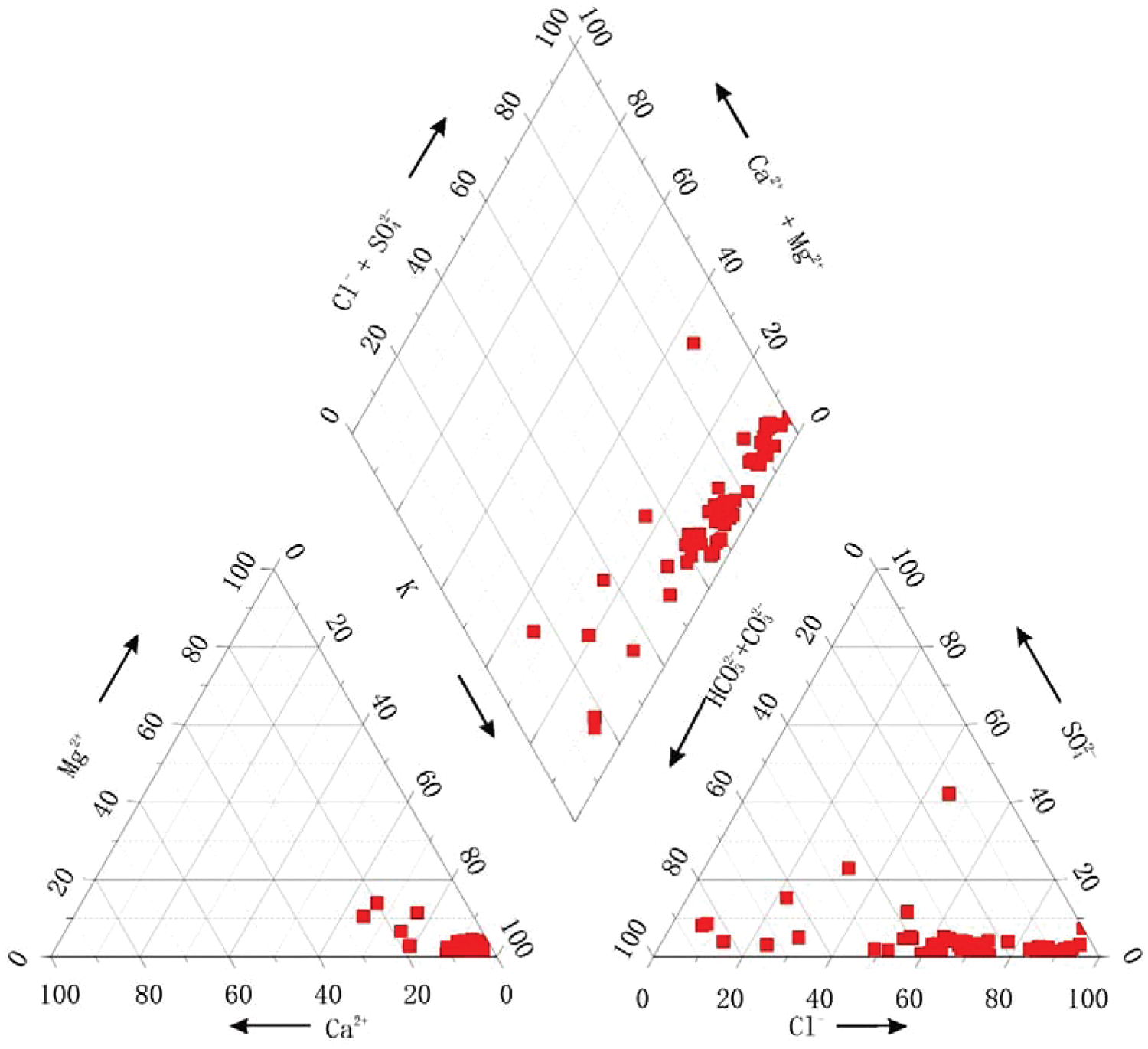
Piper histogram of the Middle-Upper Proterozoic.
Hydrogen and oxygen isotope analysis
The samples of cold water were collected from cold springs, groundwater and atmospheric precipitation. The value of δD and δ18O in the cold springs ranges from –79.9‰ to 59‰ and –11.37‰ to –8.25‰, respectively, and that of the groundwater ranges from –81.61‰ to –48.16‰ and –10.93‰ to –5.72‰. The value of the atmospheric precipitation lies on the cross line of global atmospheric precipitation (Figure 8(a)). Most of the result points of cold springs also lay on that line, but the points of the cold groundwater have a little higher value of the δ18O, which indicates slight diagenesis.
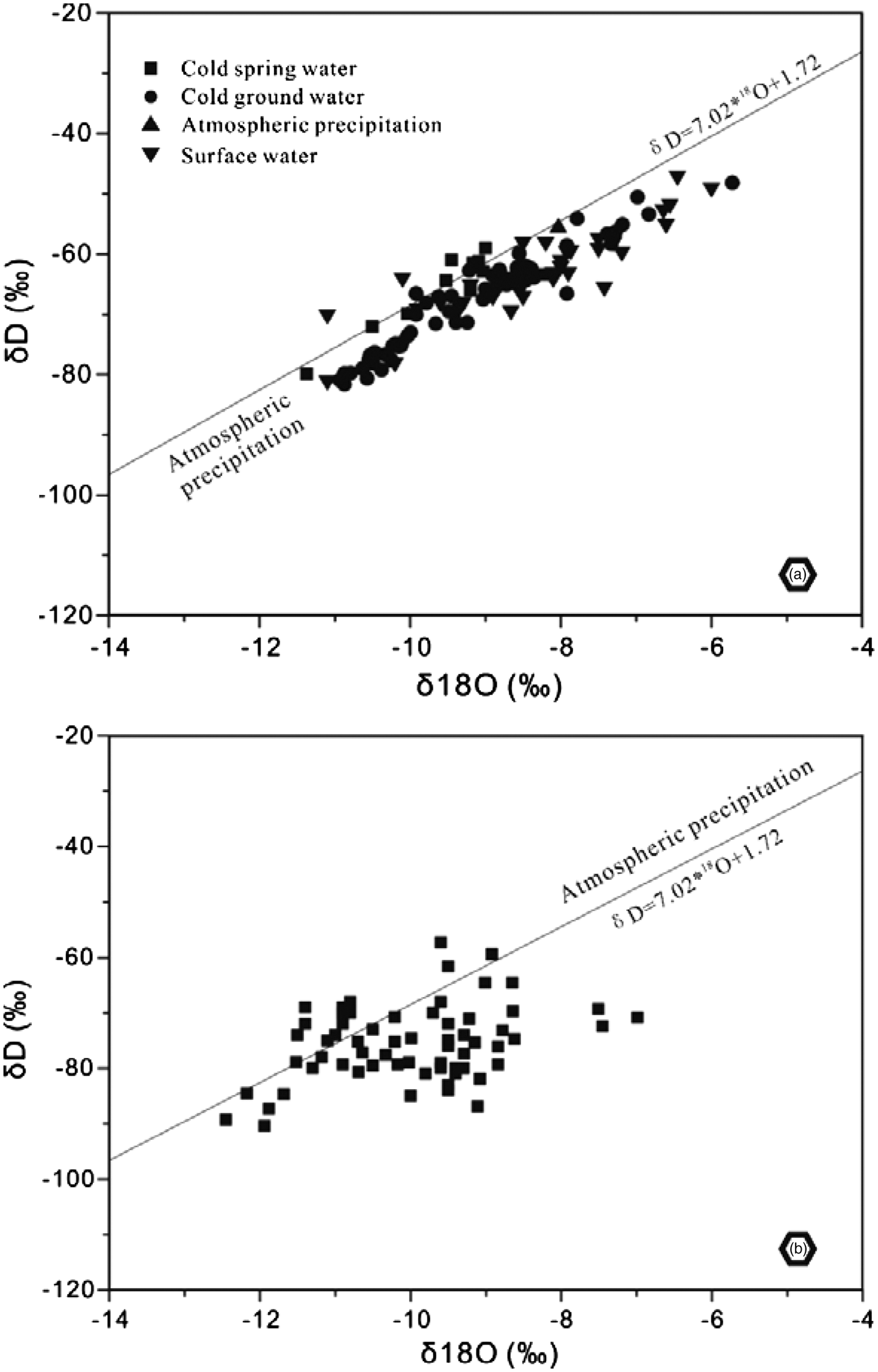
Cross plots of carbonate and oxygen isotope for cold water (a) and hot groundwater (b).
The value of the δD and δ18O in the hot groundwater varies between –90.4‰ and –57.36‰, –12.45‰ and –6.99‰, with a mean value of –75.72‰ and –9.99‰, respectively. The cross plot of δD and δ18O indicates that the result points of the hot groundwater lay in the vicinity of the line of atmospheric precipitation with an obvious oxygen drift towards the higher value (Figure 8(b)).
Groundwater salinity
The contour map of the groundwater salinity was drawn to investigate the salinity planar variations of the Middle-Upper Proterozoic. The high-value zone in the west part presents an NE-directed banded figure (Figure (9)), and the salinity in this zone is over 3 g/L and up to 8 g/L. The other high-value zone in the east part of the BTH region locates in the Cangzhou City and shows a characteristic of ring taking Cangzhou City as centre. The value of this zone is over 3 g/L and up to 15 g/L. The low-value zone distributes in the line of Beijing City – Shijiazhuang City and the area of the Tianjin City and Tangshan City. The salinity of the west low-value zone is lower than 1 g/L, and the minimum value can be lower than 0.4 g/L. The value decreases from east to west parallelly. The salinity of the east low-value zone also ranges from 1 g/L to <0.4 g/L and the value turns down from the Tianjin City to the Tangshan City.
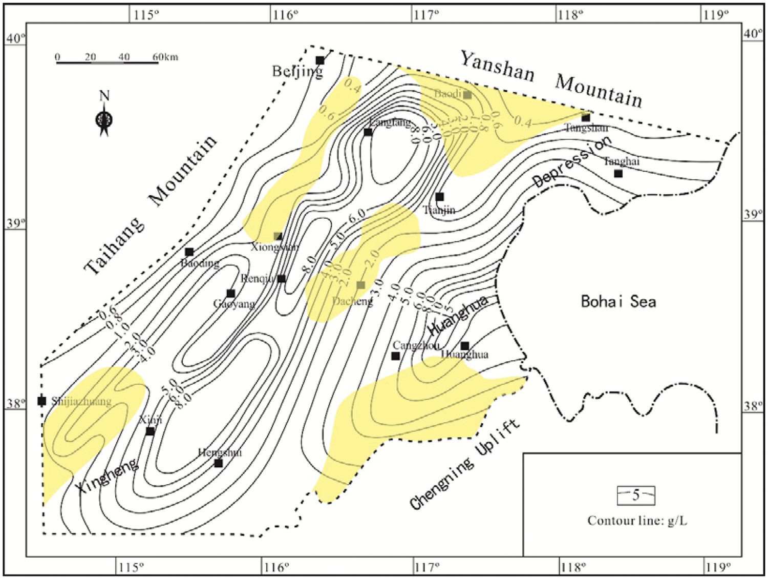
Contour map of salinity of the Middle-Upper Proterozoic. The yellow areas showing the intrabasin high and slope.
Geothermal gradient and terrestrial HF
Geothermal gradient
The geothermal gradient varies vertically and turns down dramatically from the J/P (Jurassic/Paleogene) unconformity. The geothermal gradient was calculated based on the temperature measured in wells. The geothermal gradient in the Paleogene and Neogene is much higher than that in the intervals of the Pre-Paleogene with the value ranging from 3°C/100 m to 7°C/100 m (Table 2). The gradient in the Pre-Paleogene intervals is much lower with a mean value of 2.2°C/100 m. The geothermal gradient tested in the well Ren 23 indicates an obvious differentia of the Wumishan Formation, the Cambrian and the Ordovician, and it is 1.13°C/100 m in the Wumishan Formation and about 3.5°C/100 m in the Cambrian and the Ordovician. The gradient tested in the other wells also shows this differentia (Table 2), but since the gradient of these three intervals obtained from different wells, the results cannot provide a reasonable comparison like the well Ren 23.
The geothermal gradient and the HF obtained from the hydrocarbon drilling wells.
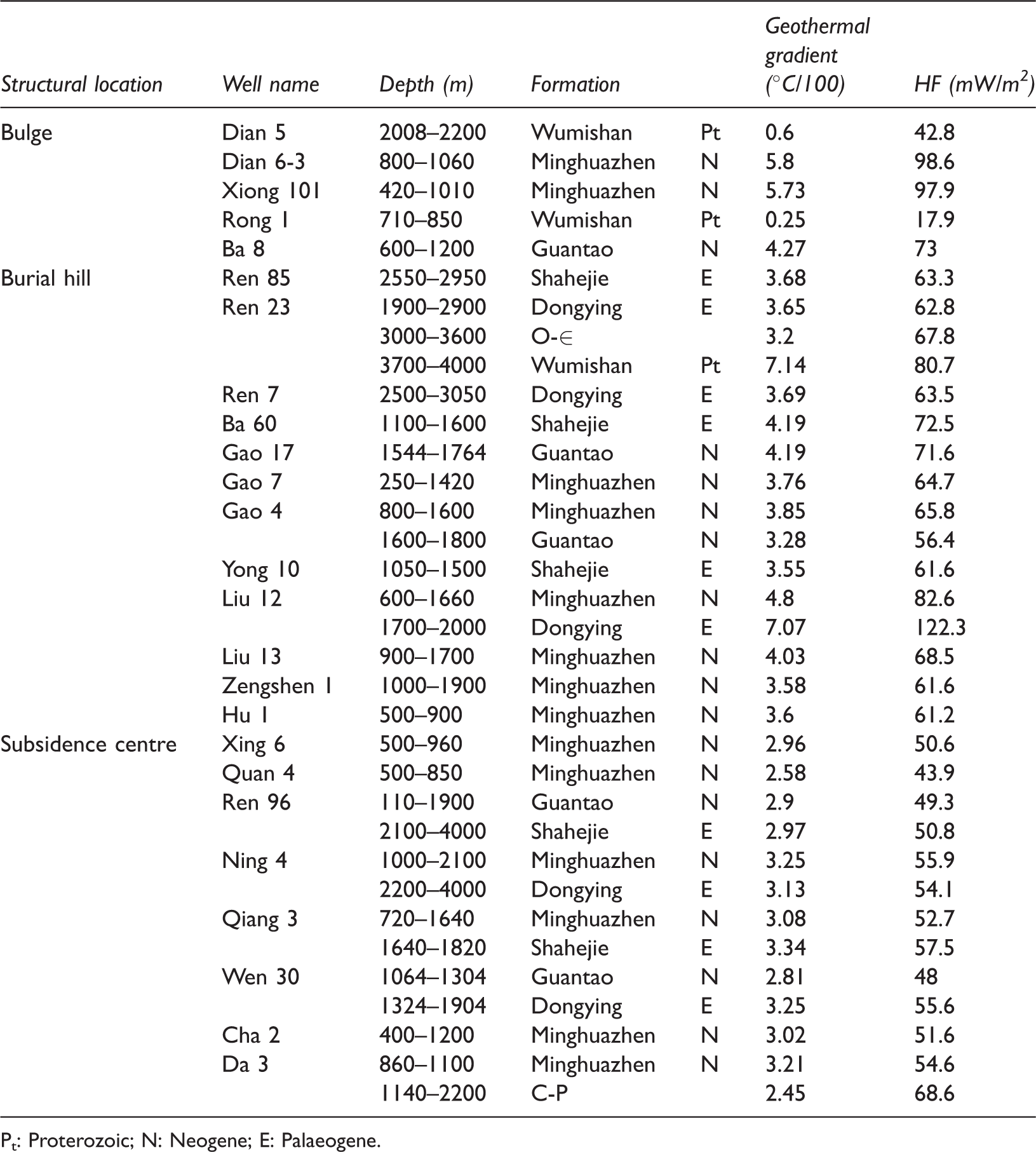
Pt: Proterozoic; N: Neogene; E: Palaeogene.
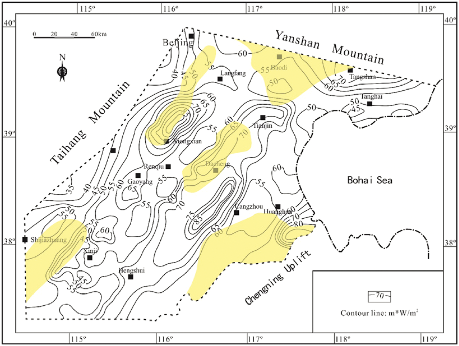
An unpublished inner report of the China Petroleum & Chemical Corporation documents the geothermal gradient variation of the Paleogene. The contour map of geothermal gradient of the Paleogene shows that the high gradient zones are figured by NE-directed band which are located in the Beijing City, and the Tianjin City – Dacheng County. The geothermal gradient in the zone of the Beijing City ranges from 3.25°C/100 m to 6°C/100 m, and the gradient increases from south to north of the Beijing City. The middle high-value zone of the Xiongxian County–Gaoyang County has a little bit higher maximum value of 7°C/100 m. The maximum geothermal gradient of the west high-value zone is situated in the area among the Dacheng County and Tianjin City with the value of 7.5°C/100 m, and the geothermal gradient turns down to 4°C/100 m towards the north. More details are shown in Figure 10.
Contour map of geothermal gradient of the Paleogene and Neogene. The yellow areas showing the intrabasin high and slope.
Terrestrial HF
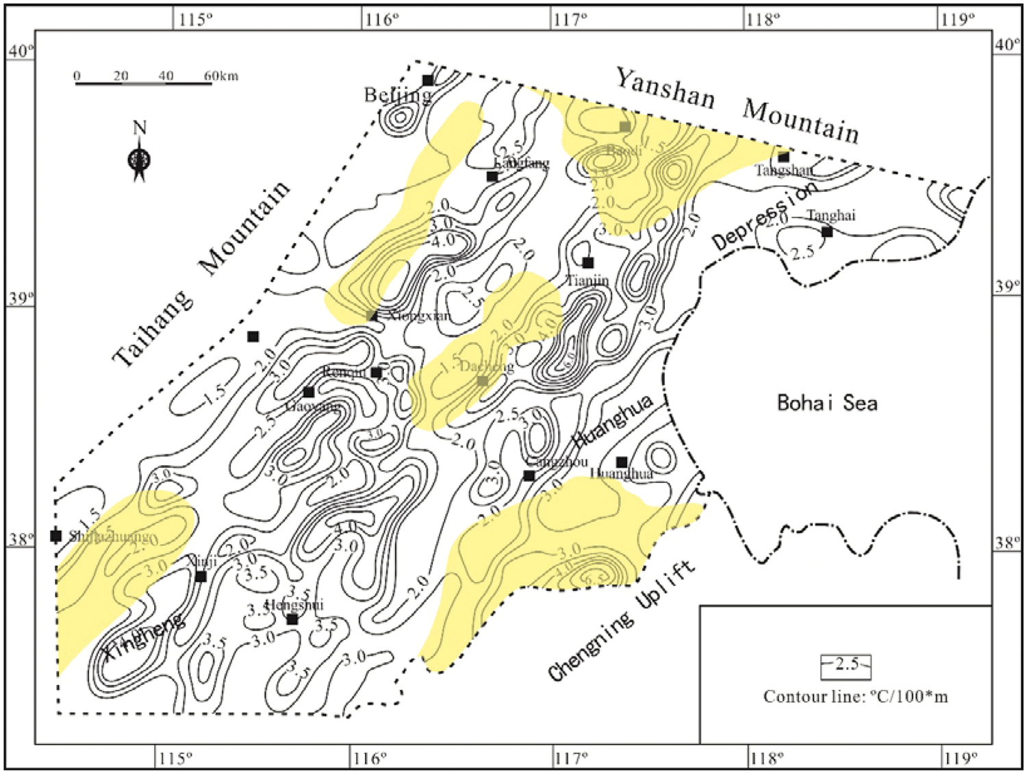
Table 2 shows the results of the terrestrial HF obtained from the Jizhong Depression. The results indicate that the HF in the intrabasin highs has a higher value than that in the intrabasin lows.
The HF tested in the bugle has a mean value of 66.04 mW/m2, and it ranges from 73 mW/m2 to 98 mW/m2 in the Neogene which is higher than that in the Wumishan Formation (17–42 mW/m2). The HF got from the Burial hills is almost the same and ranges from 60 mW/m2 to 70 mW/m2 except the value in the Wumishan Formation in the well Ren 23 and in the Neogene in the well Gao 4 with the HF of 80.7 mW/m2 and 56.4 mW/m2, respectively. The HF is generally lower than 60 mW/m2 in the depocenters except one value (68.6 mW/m2) obtained in the well Da 3.
The contour map of HF documented in the inner report was drawn based on the data of hydrocarbon drilling wells and the data collected from the Geological Institute of Chinese Academy of Sciences (Figure 11). The high-value zone of HF has the same figures as the geothermal gradient. Two banded zones are situated in the Xiongxian County–Gaoyang County and the Tianjin City–Dacheng County. The HF is up to 90 mW/m2 and 82.5 mW/m2 in the Xiongxian County–Gaoyang County and the Tianjin City–Dacheng County. In the area around the Tangshan City, the HF turns down from the Tangshan City towards the adjacent area with a maximum value of 72.5 mW/m2.
Contour map of HF. The yellow areas showing the intrabasin high and slope.
Discussion
Groundwater supply and circulation
The results of hydrogen and oxygen isotope analysis indicate that the points of the cold water including springs, groundwater and atmospheric precipitation almost lay on the vicinity of global atmospheric precipitation line, and that the points of the hot groundwater in the Middle-Upper Proterozoic have a little drift towards the high oxygen isotope zone with part of the points on the atmospheric precipitation. It is inferred that the supply for hot groundwater and cold surface water mainly originates from the atmospheric precipitation and was modified by diagenesis.
This deduction is also supported by the salinity variation of the groundwater in the Middle-Upper Proterozoic. The salinity of the groundwater increases from the boundary to the centre of the study area. Generally, the salinity rises from the source following the migration. Therefore, the groundwater has a high potential to be supplied from the Taihang Mountain in the west and the Yanshan Mountain in north. Although the migration pathway is not investigated in this study, the piedmont faults and the unconformity surface provide excellent pathway for the atmospheric precipitation migrated to the geothermal reservoirs.
The areas of intrabasin highs and slopes, which were extracted from the structure map of the Pre-Paleogene (Figure 12), were projected to the contour map of the groundwater salinity of the Middle-Upper Proterozoic, and these areas are almost located near the boundary of the study area. It indicates that the areas of high salinity overlap the highs and the slope, especially in the north part, and that the depocenters have a high salinity of groundwater (Figure 9), which also demonstrates that the groundwater originates from the Taihang Mountain and Yanshan Mountain, and that it migrates from the highs to the depocenters, and therefore the depocenter has a high salinity. Figure 1(b) shows the regional profile with the projection of salinity variation of the Middle-Upper Proterozoic. It provides a section view of the relationship between the salinity variation and Pre-Paleogene topography, and a conceptual model of groundwater supply and circulation which concludes that the atmospheric precipitation migrates from the Taihang Mountain and Yanshan Mountain, and transports to the slope or the intrabasin highs, and then concentrates in the depocenters.
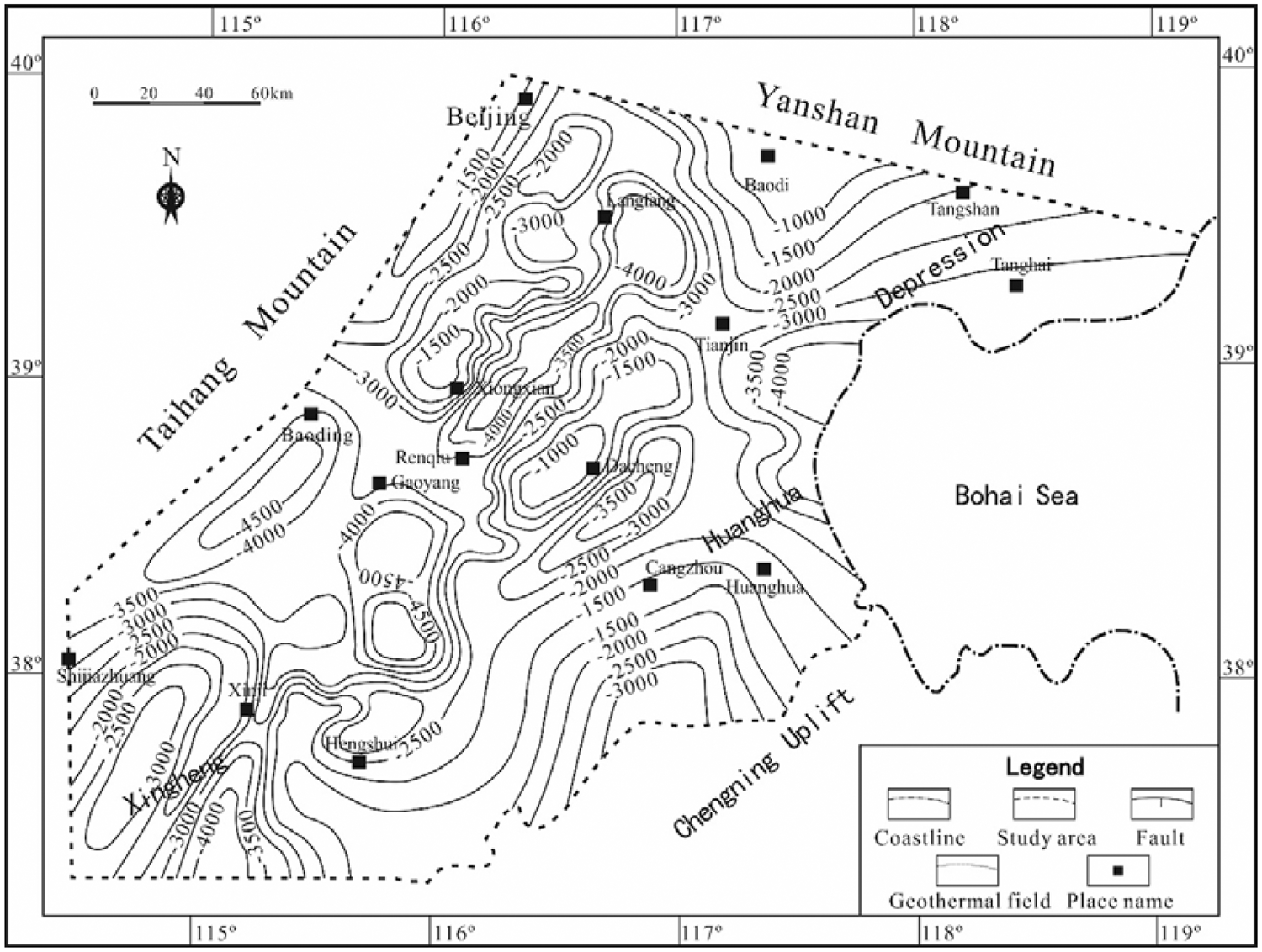
Structure map of the Pre-Paleogene.
Geothermal anomaly
The results of the thermal gradient indicate that it varies among the intervals, which is attributed to the different thermal conductivity among the dolomite, limestone and clastic rocks. When an HF is given, since the HF is equal to the product of geothermal gradient and thermal conductivity, the higher the geothermal gradient, the lower the thermal conductivity is. As the thermal conductivity of the dolomite and limestone in the study area is much higher than that of the clastic rocks which is suggested by the measurement results of the thermal conductivity that are mentioned in the texture of method, the thermal gradient is much lower in the intervals of dolomite and limestone, which deposited in the Pre-Paleogene. This vertical anomaly caused by the lithology suggests that the Paleogene and the Neogene classic intervals are good seal rocks for geothermal resources with lower thermal conductivity.
For plane anomaly, the high HF zone corresponds to the intrabasin highs. The areas of these highs were projected to the HF map (Figure 11). The high HF zone of the Xiongxian County corresponds to the high in the northwest part of the study area, and the middle-banded zone of high HF matches the highs in the Tianjin City. The north part of the study area, centred by the Tangshan City, is the same. This anomaly in planar view is attributed to the bed rock topography. In these highs, the thickness of the carbonate rocks which has a much higher thermal conductivity than the upper clastic rocks are thick, and the thickness of the upper clastic rock is only about 900 m. Therefore, the capacity of heat transmission is strong in these areas, which leads to high HF.
Magmatism also plays an important role in forming geothermal anomaly. However, its influence is limited by active ages and scale. Generally, a younger and larger magmatism has a strong influence on the geothermal anomaly. In our study area, only two small volcanic cones, which formed in Holocene, exist in Haixing County and Wudi County in Shandong Province. These two volcanic cones caused a local geothermal anomaly, but they do not account for the regional geothermal anomaly. Therefore, the magmatism was not considered during the prediction of potential areas.
The regional HF (the mean value) is 61.7 mW/m2, which is almost equal to the global average HF. The HF of the high HF zones mentioned above is over 75 mW/m2 and up to 90 mW/m2, which suggests that these zones are the high HF anomaly.
Potential areas
The geothermal fields that have been discovered and target the Wumishan Formation involves the Shahe geothermal field, the Xiaotangshan geothermal field, the Tianjin geothermal field and the Gaoyang geothermal field. All these geothermal fields are figured by low groundwater salinity and high HF and thermal gradient anomaly and are situated in the intrabasin highs or slopes. Fast and smooth groundwater circulation would decrease the concentration of ion, expressed by low salinity, which suggests effective groundwater supply. The Pre-Paleogene highs are the potential zones for paleo-karst reservoirs, and therefore the geothermal fields targeting the Wumishan Formation are related to the Pre-Paleogene highs. The underlying intervals of dolomite and limestone suggest the favourable intervals for geothermal intervals, since the clastic rocks of the Paleogene and the Neogene have lower thermal conductivity.
To determine the potential area, the threshold of HF is 75 mW/m2, which is over the regional average HF, and that of depth is lower than 2000 m that separates the basin floor into intrabasin high and low. In the pre-existed geothermal field, the geothermal resources were found above that depth. For salinity, there is no explicit limitation. It is only a indicator for groundwater transportation, and the value cannot be treated as a criterion.
Based on these criteria, several favourable areas were extracted from the overlay map of the intrabasin high and slope, and the geothermal anomaly and the distribution of the Wumishan Formation emerging on the surface of the Pre-Paleogene (Figure 13(a)) shows the distribution of the potential targets for geothermal exploration in the Wumishan Formation and the Pre-Paleogene (Figure 13(b)).
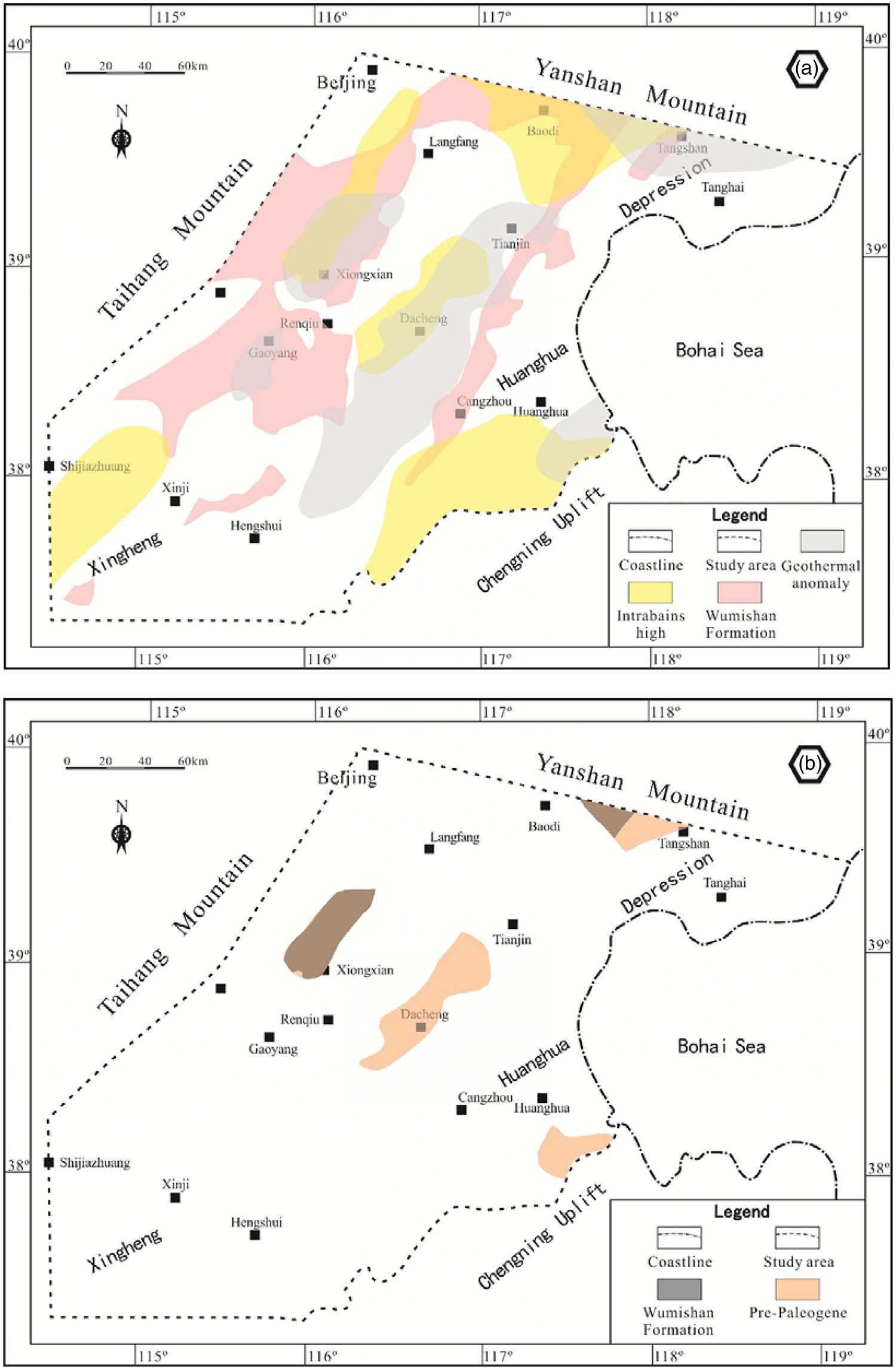
Overlay map of the intrabasin high and slope, the geothermal anomaly and the distribution of the Wumishan Formation emerging on the surface of the Pre-Paleogene (a). Favourable areas of the geothermal exploration of the Wumishan Formation and the Pre-Paleogene (b).
Conclusion
The groundwater in the Pre-Paleogene, the thermal gradient and the terrestrial HF were investigated in this study, and the Wumishan Formation was selected as the representative geothermal reservoir to give an overview of the Pre-Paleogene geothermal reservoirs of the carbonate rocks.
The reservoir space in the Wumishan Formation is mainly dominated by the supergene karst that results from the long-term weathering, and the geothermal fields that have been explored are situated in the intrabasin highs or slopes. The groundwater originates from the Taihang Mountain and the Yanshan Mountain, and transports along the highs and slopes to the depocenters, which is revealed by the hydrogen and oxygen isotope analysis and groundwater salinity. Because of the obvious difference of the thermal conductivity between the lower carbonate rocks and the upper clastic rocks, the Pre-Paleogene carbonate deposition is favourable target for geothermal exploration with the low thermal conductivity seal of the Paleogene and the Neogene clastic rocks, and the HF in the areas of the intrabasin highs or slopes, where the thickness of the high thermal conductivity is thick, is situated in the highs and slopes.
The thermal property of the rocks and the strata framework provides a congenital condition for the accumulation of the geothermal resources in the Pre-Paleogene carbonate rocks, and the favourable areas for the geothermal exploration in the BTH region are located in the intrabasin highs and slopes which have high groundwater salinity, high HF and reservoirs of high quality.
Footnotes
Acknowledgements
We are grateful to Chenglin Gong, Fei Yang (China University of Petroleum, Beijing) and Peiyi Wang (SINOPEC Star Petroleum Corporation) for their comments on earlier versions of this paper. We also thank Xinwei Wang (SINOPEC Star Petroleum Corporation) for providing data and feedback during a long-term collaboration that resulted in this paper.
Declaration of conflicting interests
The author(s) declared no potential conflicts of interest with respect to the research, authorship, and/or publication of this article.
Funding
The author(s) received no financial support for the research, authorship, and/or publication of this article.