
Abstract
The Qaidam Basin is a Cenozoic continental basin formed by the subduction and collision between the Indian plate and the Eurasian plate. It is the only large oil- and gas-bearing basin in China on the Qinghai–Tibet Plateau. The Qaidam Basin has recorded the uplift of the plateau with its complete Cenozoic sequences. Therefore, studying the structural characteristics of the Qaidam Basin helps us to understand the uplift of the Qinghai–Tibet Plateau. Studies have shown that the structural activities in the Qaidam Basin were episodic, transformable, and inconsistent, which reflected the characteristics of the uplift of the Qinghai–Tibet Plateau. In general, the structural activities of the Qaidam Basin are divided into three phases, which are characterized by the shifting of structural activities from the south to the north, the west to the east, and from the margin to the hinterland of the basin, respectively. The intensity of the early activity was greater than that of the early basin in both time and space. In conclusion, the uplift of the Qinghai–Tibet Plateau controls the structural and sedimentary characteristics of the basin and ultimately, the hydrocarbon accumulation and distribution of the basin.
Keywords
Introduction
The uplift of the Qinghai–Tibet Plateau triggered a large number of geological events in the Cenozoic era. Its complex massif amalgamation mechanism, orogenic process, and growth model are still the focus of the most advanced research in domestic and foreign academic circles (Hou et al., ,2006; Royden et al., 2008; Wang et al., 2008). A series of sedimentary basins with potential oil and gas resources have been developed in and around the plateau, which is a new field of oil and gas resources investigation in China (Qiu and Fang, 2005). Among them, the Qaidam Basin is the only large continental oil- and gas-bearing basin in the Qinghai–Tibet Plateau where large-scale reserves have been discovered and large-scale productions have been built. The collision and compression of India and Eurasia during the Cenozoic period and the uplift of the Tibetan Plateau are among the most important geological and tectonic events of this period, and is denoted as the “Himalaya Orogeny” by scholars (Yu et al., 2017; Zhang et al., 2013). The Qaidam Basin in the northeastern margin of the Plateau is a large continental basin that began to form in the Cenozoic era, and its formation and tectonic evolution are closely related to the Himalaya Orogeny (Burchfiel et al., 1989; Gaudemer et al., 1995). Many scholars have conducted in-depth and extensive studies on the geometric, kinematic, and dynamic characteristics of the formation and evolution of the Qaidam Basin, obtaining numerous important results. Various formation modes have been proposed, including the extension–contraction model (Wang et al., 2004; Wang et al., 2020; Xia et al., 2001), the foreland basin model (Jia et al., 2003; Jia et al., 2022;), the basin-edge uplifting to piggyback model (Yin et al., 2008), and the crustal buckle-fold model (Fang et al., 2007). Although different scholars have debated on different dynamic models, they largely agree with each other on the structural activities of the Qaidam Basin, namely, that the uplift of the plateau was episodic and spatiotemporally variable. This is reflected by structural styles, sedimentary thickness, deposition rate, and filling structure of the basin. Research on the Qaidam basin is of great significance for the understanding of the formation of the Qinghai–Tibet Plateau, as well as the oil and gas accumulation within the basin. The Qaidam Basin is the largest Cenozoic basin formed during the uplift of the Qinghai–Tibet Plateau, and is one of the areas most directly affected by the uplift of the Qinghai–Tibet Plateau. However, previous studies on the relationship between the formation and evolution of the basin structure and the uplift of the Qinghai–Tibet Plateau, as well as the origin of the huge differences in the basin structure, are limited. In particular, research on the coupling relationship between the particularity of the formation and evolution of the Qaidam Basin and the uplift of the Qinghai–Tibet Plateau is inefficient. Furthermore, the causes of the differential uplift, differential subsidence, and differential denudation of the basin remain unknown, and the three major depressions of the basin lack a unified genetic interpretation.
The multistage episodic uplift background of the Qinghai–Tibet Plateau results in a complex tectonic environment and unique hydrocarbon accumulation conditions in the Qaidam Basin (Fu et al., 2015; Guo et al., 2017; Liu et al., 2020). Predecessors have successively constructed a variety of oil and gas accumulation models, such as the hydrocarbon-rich sag paleotectonic reservoir, out-of-the source paleo-uplift paleo-slope reservoir, the upper late source structural reservoir, and the tight oil lithologic reservoir in the source of the hydrocarbon-rich sag (Gao et al., 2014; Guo et al., 2017; Ni et al., 2019). It is generally believed that the hydrocarbon accumulation period in the Qaidam Basin is late due to the influence of the neotectonic movement. The late structure has dual effects on oil and gas reservoirs, namely, the destructive and constructive coexistence of oil and gas accumulation (Liu et al., 2007; Qin et al., 2022). On the whole, previous research on the hydrocarbon accumulation in the Qaidam Basin has achieved fruitful results and has effectively guided exploration studies. However, in-depth investigations of the relationship between the plateau uplift and basin hydrocarbon accumulation are lacking.
We use seismic interpretation, the growth-fault index, and sedimentary rate analysis to perform a comprehensive study on the structural styles in different regions of the Qaidam Basin. In addition, we analyze the temporal–spatial differences of the structural evolution as well as the oil and gas distribution patterns in the Qaidam Basin.
Geological background
The Qaidam Basin is located in the northwestern region of the Qinghai Province, at the northeastern edge of the Tibetan Plateau (Figure 1), and is located at the junction of the paleo-Asian tectonic domain and the Paleo-Tethys–Himalayan tectonic domain. It is surrounded by the Altun, Qilian, and Kunlun Mountains with an area of approximately 130,000 km2. It is a Cenozoic terrestrial basin formed during the collision and subduction of the Indian plate with respect to the Asian plate and accompanied by the uplift of the plateau. It is the largest Cenozoic basin on the Qinghai–Tibet Plateau and the basin with the largest oil and gas production and reserves (Fu et al., 2016; Liu et al., 2020).
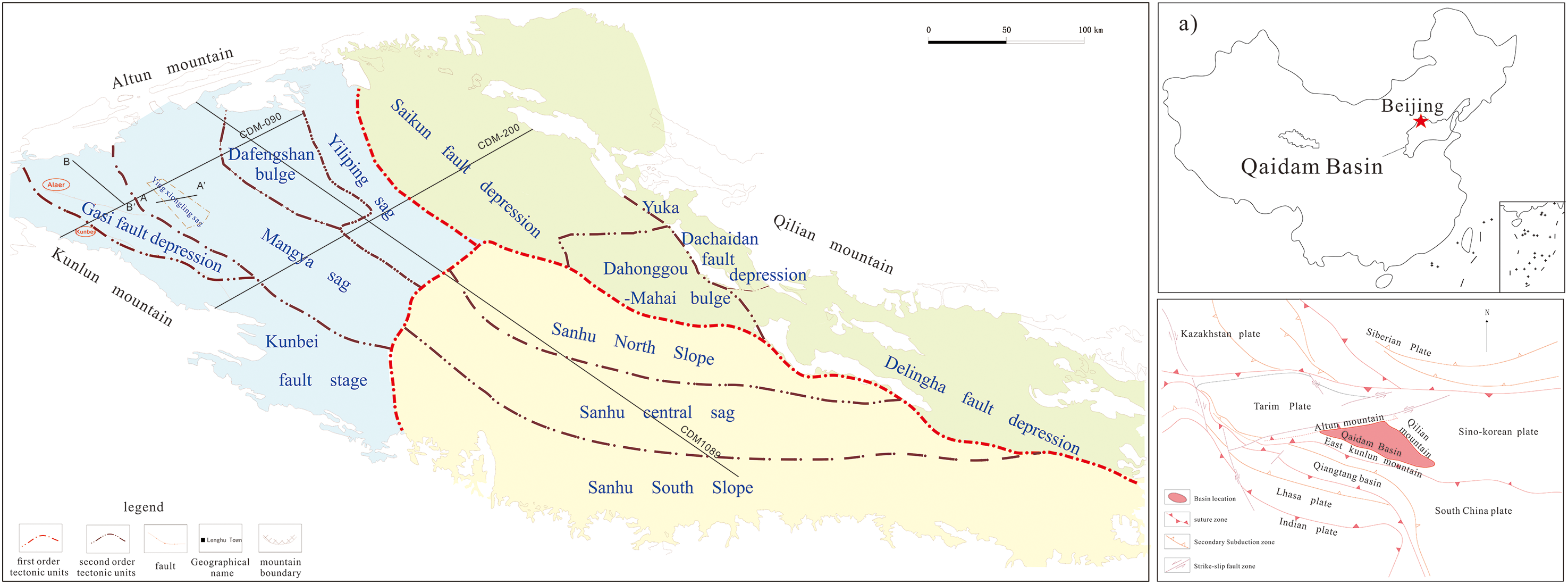
Study area and tectonic background.
Previous studies have classified the tectonic units of the Qaidam Basin in terms of numerous aspects, such as the basement properties and fluctuation characteristics, the tectonic and sedimentary evolution, and the fault distribution and evolution, gradually forming a variety of schemes. Based on the distribution of the basin exploration target layers, the basin can be divided into three primary tectonic units, namely the western Qaidam uplift, the northern margin uplift, and the Sanhu Depression, and 12 secondary tectonic units (Chen et al., 2019; Fu, 2010; Yuan et al., 2011).
Predecessors divided the tectonic evolution of the Qaidam Basin into two cycles and four stages of evolution. The two major cycles are the trough block cycle developed in the transitional margin rift in the late Paleozoic and the orogenic basin cycle developed in the superimposition of the fault depression to the compression depression in the Mesozoic and Cenozoic eras. The four stages of evolution are the late Paleozoic back-arc rifting, Mesozoic extensional faulting, early Mesozoic-Cenozoic intracontinental faulting and depression, and late Cenozoic intracontinental strike-slip compression. The formation of the present-day tectonic framework in Qaidam is mainly controlled by the latter two periods (Sun et al., 2005). Since the Cenozoic, the basin has undergone several basin evolution stages, including the initial Paleocene-Eocene fault depression, the strong compression from the Oligocene to early Miocene, and the strong shrinkage of the uplift after the late Miocene, while some scholars also believe that the strike-slip movement is not negligible for the formation of the Qaidam Basin. However, there is little difference in the period division of the evolutionary stages. Different basin evolution models such as the synclinal model, the eastward extrusion model, and the extruded escape model have been proposed by different studies (Fang et al., 2007; Jolivet et al., 2003; Wang et al., 2006; Yin et al., 2008).
Various types of sedimentary systems such as braid river deltas, fan deltas, and alluvial fans have developed in the basin (Su et al., 2015), and the Paleogene Lulehe Formation, the lower Ganchagou Formation, the upper Ganchagou Formation in the upper Neogene, the lower Youshashan Formation, the upper Youshashan Formation, the Shizigou Formation, and the Qigequan Formation were deposited from the bottom up in the Cenozoic (Yi et al., 2011), with a thickness of up to 1.8 km (Figure 2). The formation and evolution of tectonics in the Qaidam Basin vary significantly in time and space from the pre-mountain basin margin to the inner basin, from the south to the north, from the east to the west, and from the deep to the shallow areas. These spatial and temporal characteristics of the tectonic deposits in the Qaidam Basin are precisely a response to the phased, shifting, and uneven uplift of the Qinghai–Tibet Plateau.
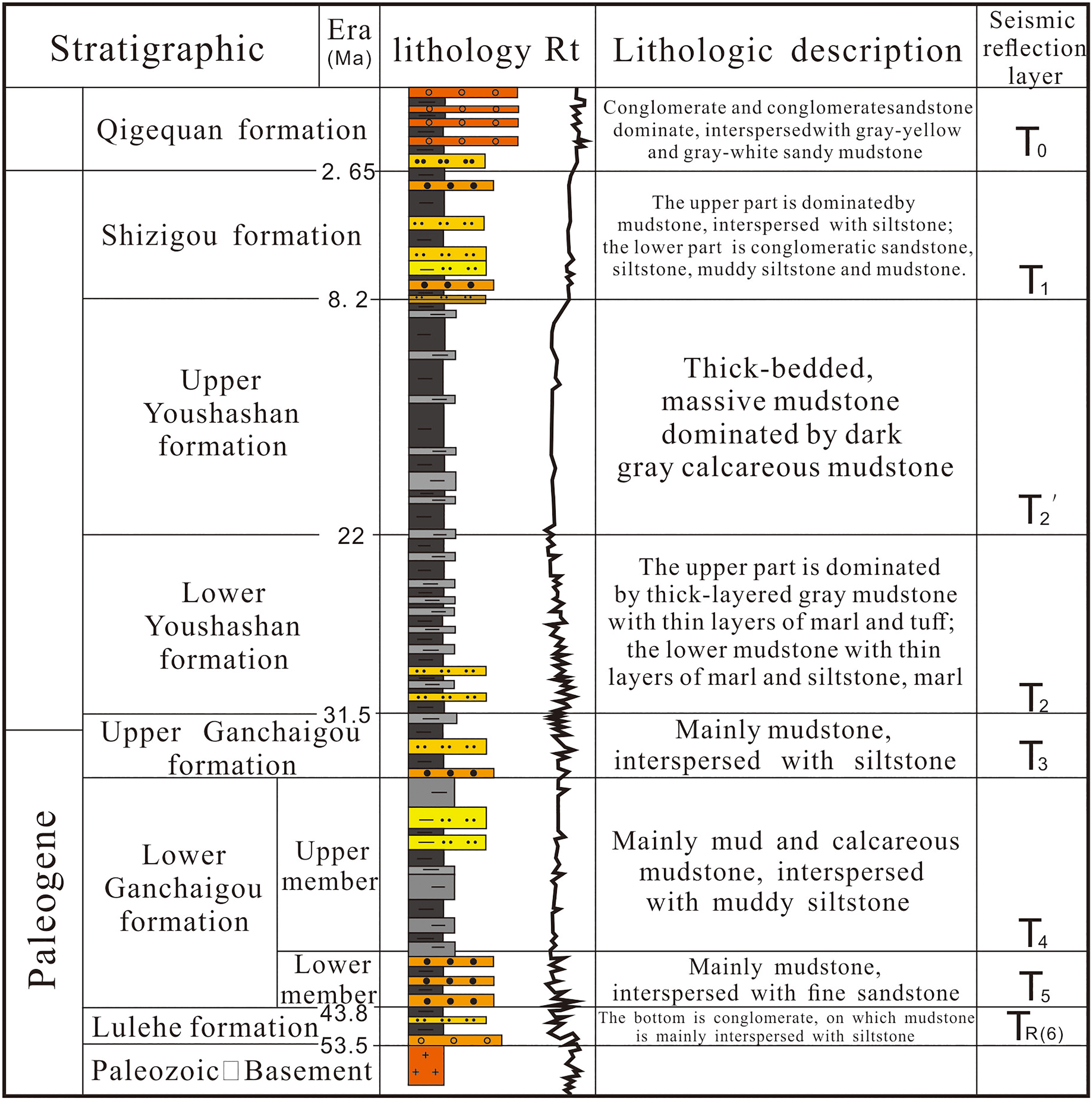
Comprehensive histogram of the Cenozoic strata in the Qaidam Basin.
Analytical methods
In order to further clarify the characteristics of the Cenozoic tectonic evolution in the Qaidam Basin, this study mainly focuses on the cross-comprehensive analysis of geological and geophysical methods, with the following aims: (1) to identify and trace unconformities on seismic profiles using seismic stratigraphic methods; (2) to analyze the main fault activity characteristics of the basin using the fault activity rate; (3) to analyze the tectonic style and activity intensity of large basin structures using the joint profiles; and (4) to determine the thickness of each period of the basin based on the well seismic system. The aforementioned research methods are generally based on the fine interpretation of basin level seismic data. The seismic data are derived from 2D seismic survey lines in the basin area and high-precision 3D seismic survey lines in the western Qaidam Basin collected by PetroChina Qinghai Oilfield Company during 2003–2016. The data are processed and loaded into professional seismic data interpretation software to interpret unconformity surfaces, regional strata, and faults. Through the quantitative study of these four analytical methods, we can not only clarify the activity characteristics of each tectonic evolution stage of the Himalaya Orogeny phases, but also further explore the control mechanism of the basin evolution stage on the petroleum geological conditions from a macroscopic perspective. Moreover, combined with previous achievements in thermal chronology and paleoenvironment, a comprehensive tectonic evolution model of each period of the basin is established, providing guidance for oil and gas exploration in the basin.
Response of the uplift characteristics of the Qinghai–Tibet Plateau to the Qaidam Basin
The tectonics of the Qaidam Basin are very complex with a variety of structural styles. There are great differences between pre-mountain and intra-basin tectonics, the western and eastern structures, and the deep and shallow structures of the basin, and great changes have taken place in the early and late structures. Although there are great differences in the nature of the tectonics, development, evolution, and intensity of activities, the structural activities in the Qaidam Basin exhibit certain trends. In other words, they show obvious characteristics of vertical stages, horizontal migration, and imbalance.
Stages of structural activities in Qaidam Basin
The structural activities in the Qaidam Basin are characterized by significant phases based on the period of tectonic activity, the development of unconformity, and the changing response of the growth of syngenetic faults. The phases of the structural activities are first reflected in the faults as a combination of multiple phases of faulting in the vertical direction, with some differences in each phase, followed by the formation of multiple phases of the regional unconformity during the deposition process, and lastly, the different activity characteristics of the syngeneic fault phases. These structural activities are characterized by the obvious coupling relationship with the Himalaya Orogeny phases.
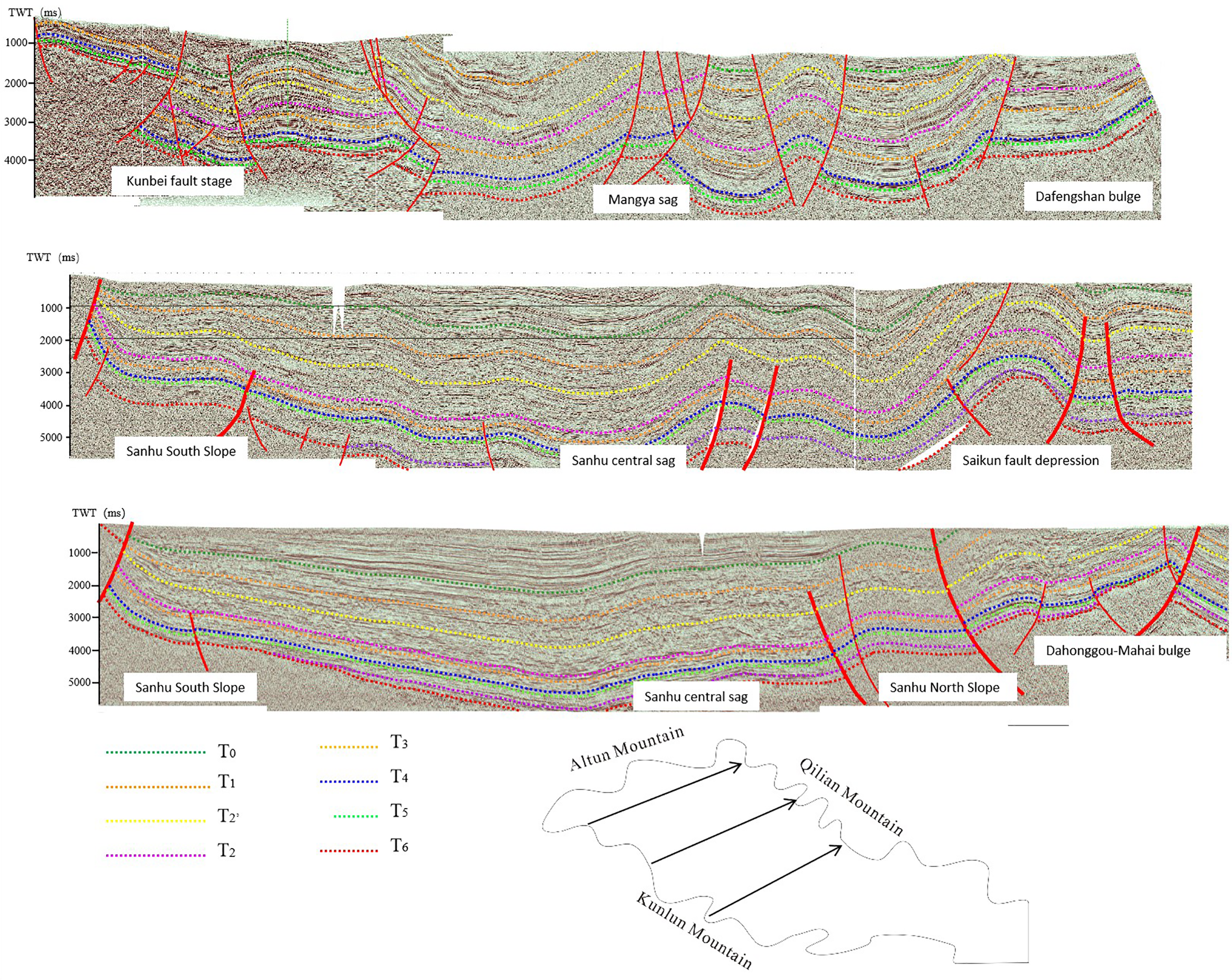
The faulting activities in the Qaidam Basin can be divided into three phases. Vertically, the most significant manifestation of the staged activity of fractures is the large tectonic belts in the hinterland of the basin, such as the Yingxiongling tectonic belt located inside the Monya depression in the western part of the basin (Figure 3). It can be seen from the seismic section that the early structural activities included a large basement fault thrusted from the south to the north, terminating in the Lulehe Formation. This period corresponds to the Himalaya Orogeny I. At this time, the Indian plate and Eurasian plate initially collided (Zhang et al., 2006), causing a series of mountain systems such as the Himalayas to appear in sequence and the substantial uplift of the Qinghai–Tibet Plateau, which has not fully spread to the Qaidam Basin. The Cocosi Basin in the south, the Suganhu Basin in the north, and the Qaidam Basin were still integrated at this time (Fu et al., 2012, 2016; Zhao et al., 2003), and the basin compression deformation was weak. Thus, the fault displacement in this period is small. The middle tectonic period was transformed into an imbricate structure thrust from the north to the south, ending in the salt layer of the lower Ganchagou Formation. This period corresponds to the Himalaya Orogeny II, namely, the late Paleogene to early Neogene, which is an important turning point in the evolution of the Qinghai–Tibet Plateau and the Qaidam Basin. The sedimentary scope and regional pattern of the basin began to undergo strong modifications during this period, with the first appearance of the Altun Mountains (Wang et al., 2004; Yin et al., 2008), and the beginning of the large-scale uplift of the Eastern Kunlun Mountains (Dai et al., 2005; Guan and Jian, 2013). The late structure is a north-to-south decollement overthrust fault, downward into the Upper Ganchagou Formation-Upper Youshashan Formation, and upward to the surface, corresponding to the Himalaya Orogeny III. The present-day Eastern Kunlun Mountains began to uplift rapidly at the beginning of the Miocene, and their overlying strata were strongly denuded, causing the Cocosi Basin and the Qaidam Basin to develop independently of each other (Wang et al., 2008). The southern sedimentary boundary of the Qaidam Basin migrated more than 200 km to the north (Xia et al., 2001). The three phases of tectonic development are different in time and in horizons. The nature of the fracture and structural styles are also distinct, representing different stages of structural activities in the Qaidam Basin, and are also the response of the uplift of the Qinghai–Tibet Plateau in the basin.
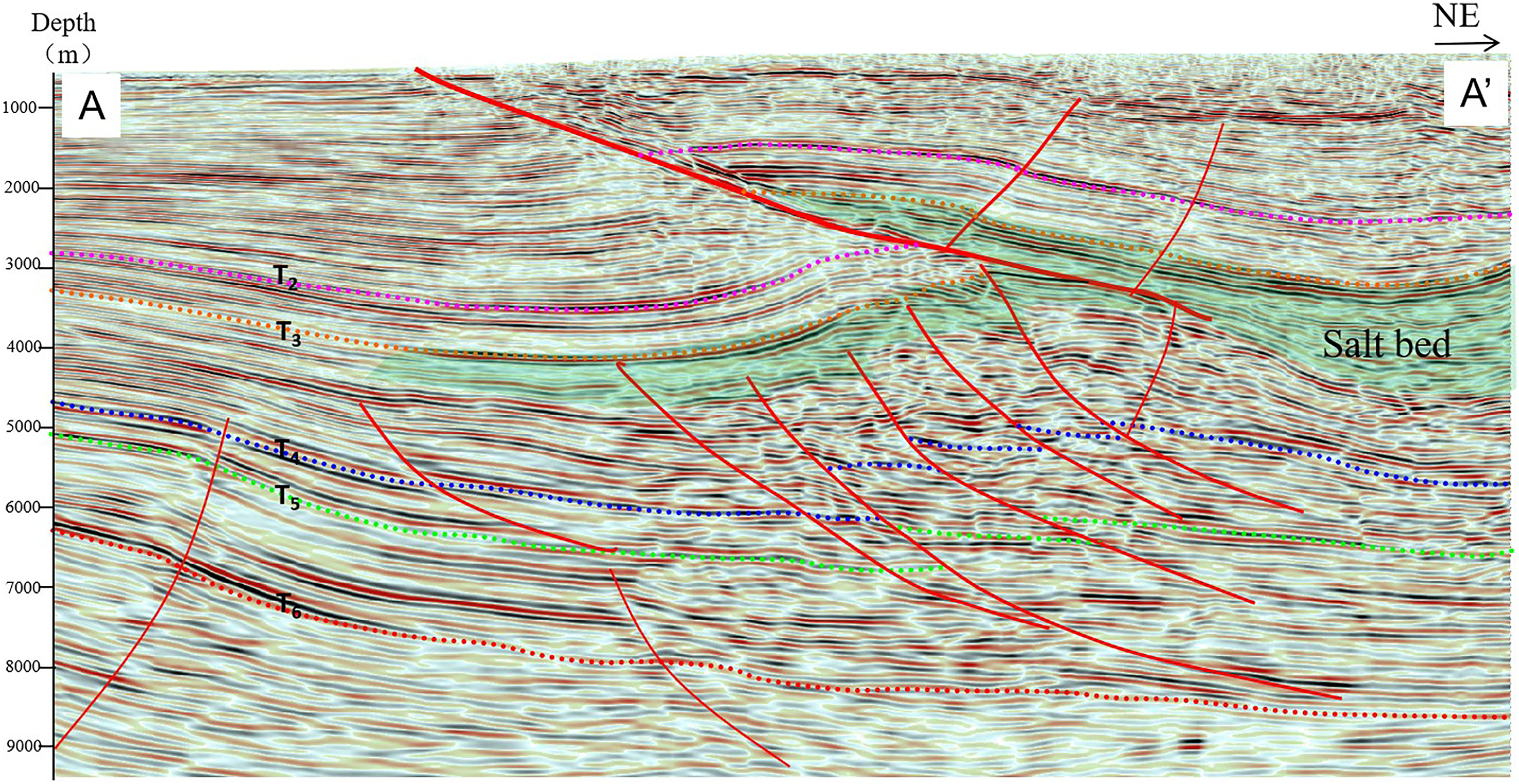
Seismic profile of the Xiongling area in the Qaidam Basin (see Figure 1 A-A’ for section location).
The development of three major unconformities in the Qaidam Basin is presented in Figure 4, and is the most significant sign of the uplift phases of the Qinghai–Tibet Plateau. The first unconformity developed between the strata of the upper and lower Ganchagou Formations. It is a large regional unconformity in the early Xishan Movement period, distributed in the whole basin and is the manifestation of the strongest tectonic activity in the Qaidam Basin. It is also one of the strongest signs of uplift of the Qinghai–Tibet Plateau. The second unconformity developed between the upper and lower Youshashan Formations, and is the response to the mid-Himalaya Orogeny. This unconformity is only locally developed, showing as angular unconformity in the basin margin and the periphery of the uplift, and is parallel unconformity in the basin. The third is the unconformity between the Shizigou Formation and the Qigequan Formation. It is a parallel unconformity distributed throughout the region during the late Himalaya Orogeny, and only shows angular unconformity in some basin margin areas and high structural zones. The three unconformity phases are consistent with the three phases of the Himalaya Orogeny, and are a reflection of the uplift of the Qinghai–Tibet Plateau.
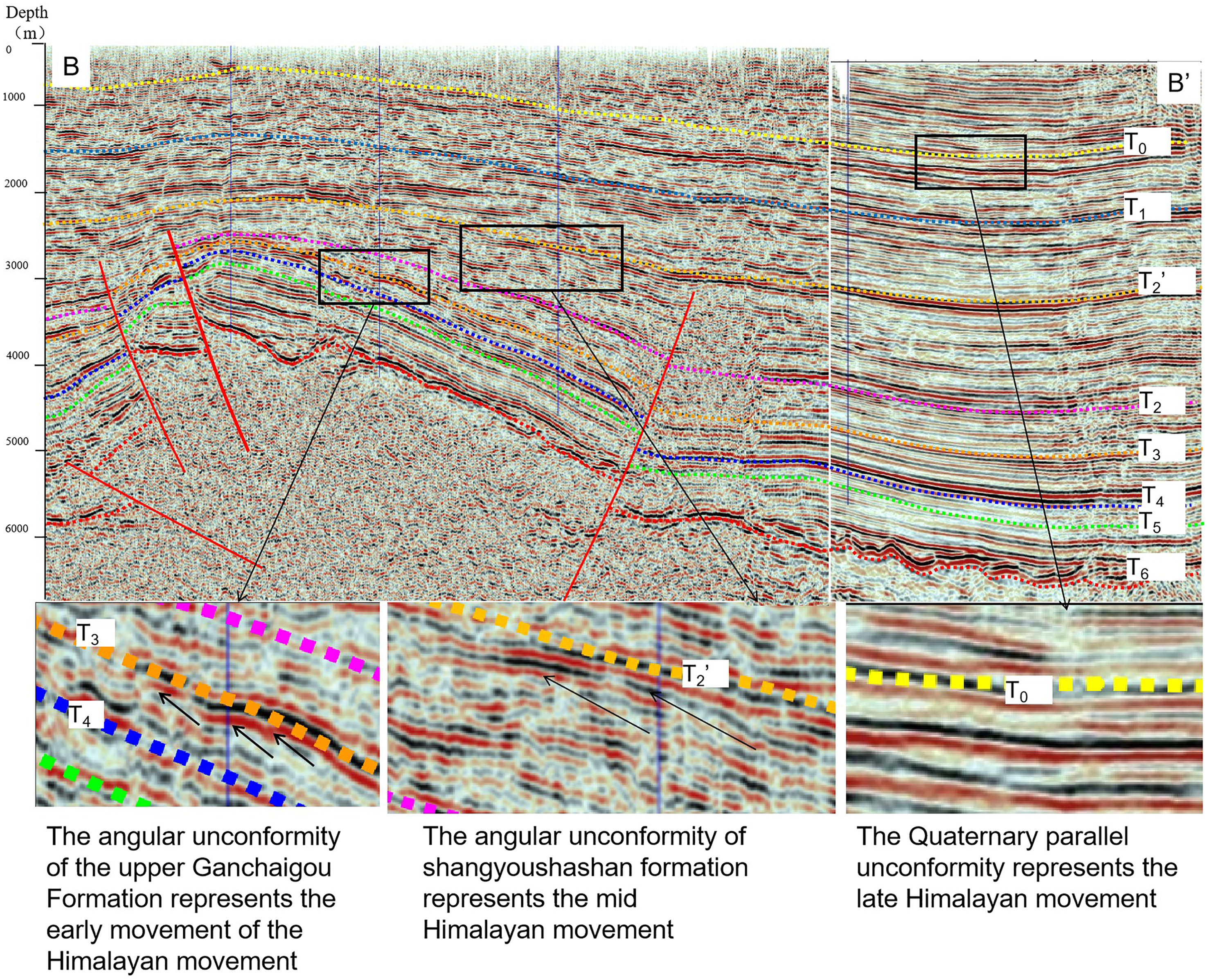
Characteristics of the stratigraphic unconformity seismic profile in the Qaidam Basin (see Figure 1 B-B’ for the section location).
The growth index and sedimentation rate of growth faults in the Qaidam Basin also exhibit different stages. The most famous growth fault in the Qaidam Basin is the Alar fault. The fault is located in the southwest of the Qaidam Basin, extending in an NWW-near east–west direction, with an extension distance of 90 km and a fault displacement of 4 km. It began to move from the Lulehe Formation to the Shizigou Formation. According to research on the growth index of Alar fault in Figure 5, the activity of Alar fault can be divided into three phases. The most severe is the sedimentary period of the lower Ganchaigou Formation and the upper Youshashan Formation, which is consistent with the development characteristics of unconformity and tectonic activity. The change of sedimentation rate also exhibited periodicity as shown in Figure 5, which was also a response to the stages of the Himalaya Orogeny. The fission track length and ZTR(ZTR index, i.e. the total number of zircon, tourmaline and rutile. The above minerals are extremely stable heavy minerals in rocks with strong weathering resistance) index of apatite at the Kunlun and Altun Mountains were also calculated. A high ZTR index is often used to indicate high mineral maturity and a long transport distance, and thus the distribution characteristics of the ZTR index can clearly reflect the hydrodynamic conditions in the geological history period. A relatively low ZTR index indicates that the mountain system is strongly uplifted and the material source supply is sufficient. As can be seen from Figure 5, the ZTR index is low in the early N1-late E32, N22, and N23 periods while the index is high in the middle E32 period. This reveals that at this time, the rivers in the basin are relatively developed, mainly with a stable subsidence. In addition, the fission track age represents a stage of the tectonic thermal event. In this study, the number of fission track ages of the Altun and Kunlun magmatic rocks is calculated. The larger the number during a certain period, the more intense the structural activities, and its law essentially matches with the three phases of Himalaya Orogeny. The number of E32 in the Kunlun Mountain is relatively large, while that in the Altun Mountains is relatively small. This reveals that although the Qinghai–Tibet Plateau was uplifted at this time, its influence was limited to the southern region of the basin.
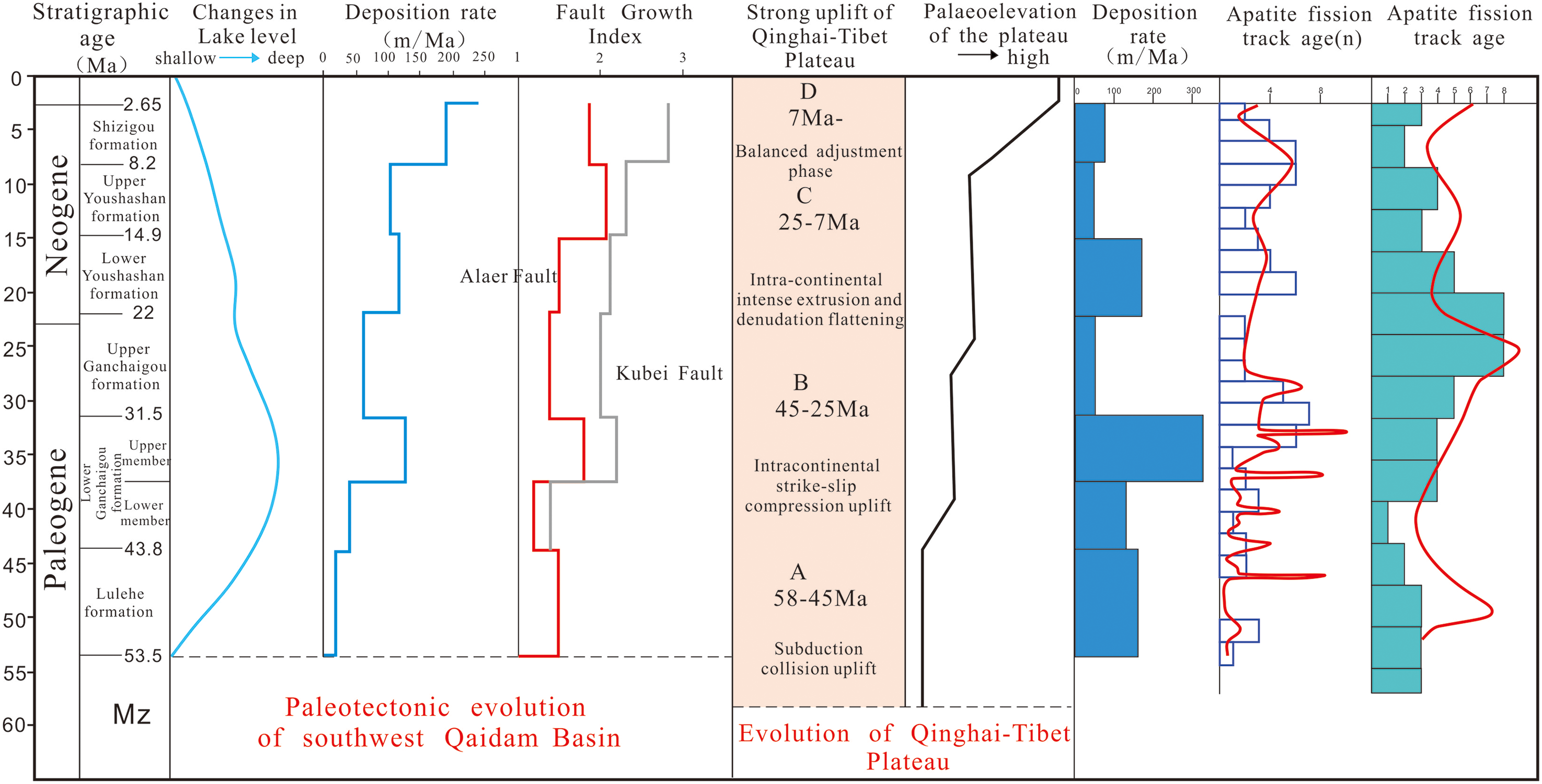
Tectonic evolution of the Qaidam Basin. (ZTR index data are obtained from Wang et al., 2004; Wang et al., 2006; Wang et al., 2008; Wang et al., 2020; apatite fission tracks are obtained from Xia et al., 2001 and Yi et al., 2011).
The transferability of structural activities in the Qaidam Basin
Another remarkable feature of the tectonic activity in the Qaidam Basin is its transferability. The structural activities are characterized by a shift from the west of the basin to the east, from the south of the basin to the north, and from the margin of the basin to its hinterland. This movement is consistent with the movement characteristics of the Himalaya Orogeny and the uplift of the Qinghai–Tibet Plateau, and is the specific response of the uplift of the Qinghai–Tibet Plateau in the Qaidam Basin.
From the south to the north of the basin.: The tectonic activity of the Qaidam Basin shifts from the south to the north, which may be related to the compressive stress originating from the south. As can be seen from Figure 6, the fault in front of the Kunlun Mountains began to be active from the beginning of Paleogene sedimentation had continued to be active, while in front of the Altun Mountains in the north, the fault activity was late and formed in the sedimentary period of the Upper Youshashan Formation at 14.9 Ma, belonging to the late structure.
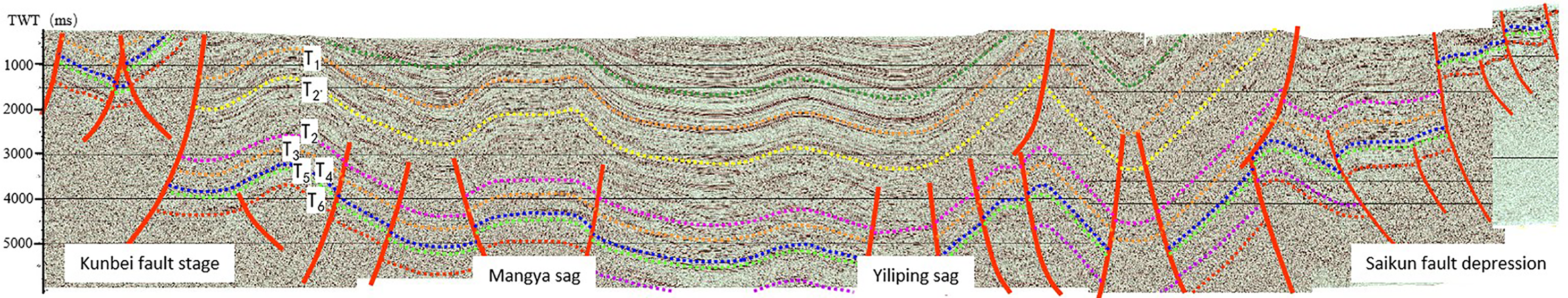
CDM-090 seismic profile of Qaidam Basin (see Figure 1 for the section location).
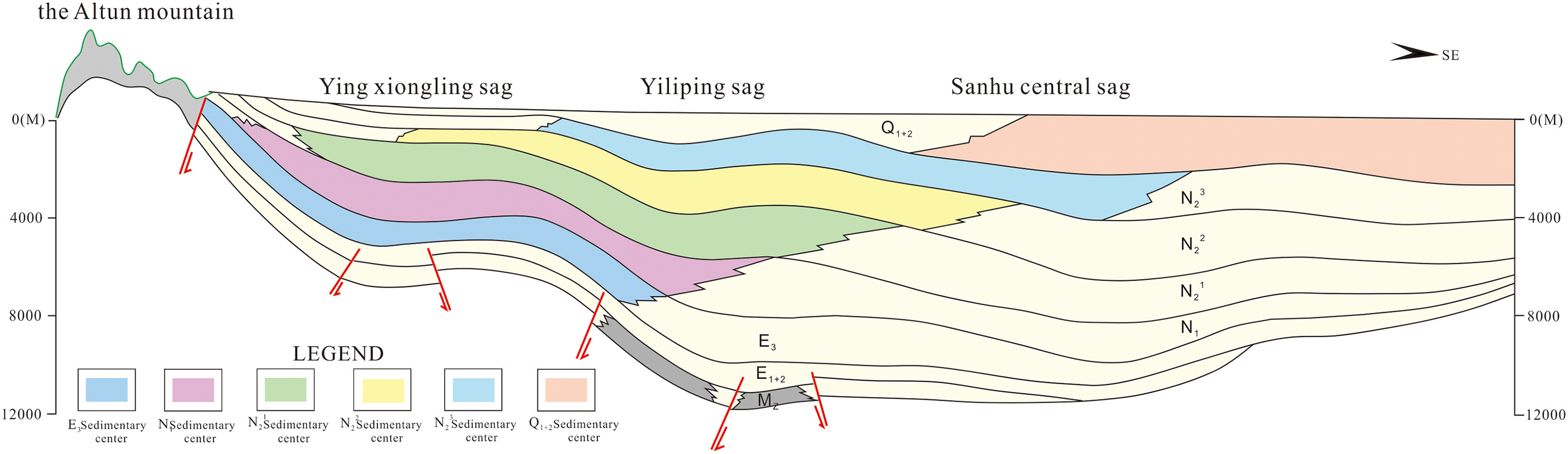
Transfer from the basin edge to the interior of basin: The structural activities in the Qaidam Basin transferred from the edge of the basin to its interior. As can be seen from Figure 8, the basin margin activity started early (from the beginning of basin formation) and ended late. The thrust fault in front of the Kunlun Mountains is a growth fault, which began to be active when the Lulehe Formation of the Paleogene was deposited, and continued until the end of the Cenozoic. The thrust fault in front of the Qilian Mountains was active slightly later, but still during the deposition of the Lulehe Formation, and lasted until the end of the Cenozoic era. Compared with the edge of the basin, the majority of the faults in the hinterland of the basin started late and were dominated by late structures. Generally, the activity began in the sedimentary period of the N22-N23 stratum. The most intense activity was in the Quaternary sedimentary period, and late large structures in rows and belts were formed in the hinterland of the basin in as shown in Figure 8.
From the west to the east of the basin: The tectonic activity in the Qaidam Basin is clearly from the west to the east The activity in the east is earlier than that in the west, both at the edge of the basin and in the hinterland of the basin. It can be seen from Figure 7 that the fault activity in the western part of the Kunlun Mountains starts synchronously with the basin formation. Toward the eastern part of the Kunlun Mountains, the fault activity moves southeast, and not only starts late, but also ends early. Furthermore, in the later stage, the basin-orogen structure changes from fault contact to slope. However, in the hinterland of the basin, the activities in the western region are not only earlier, but can also be divided into three periods. There is only one period of activity in the eastern region, namely, the concentric anticline formed by late structural activities.
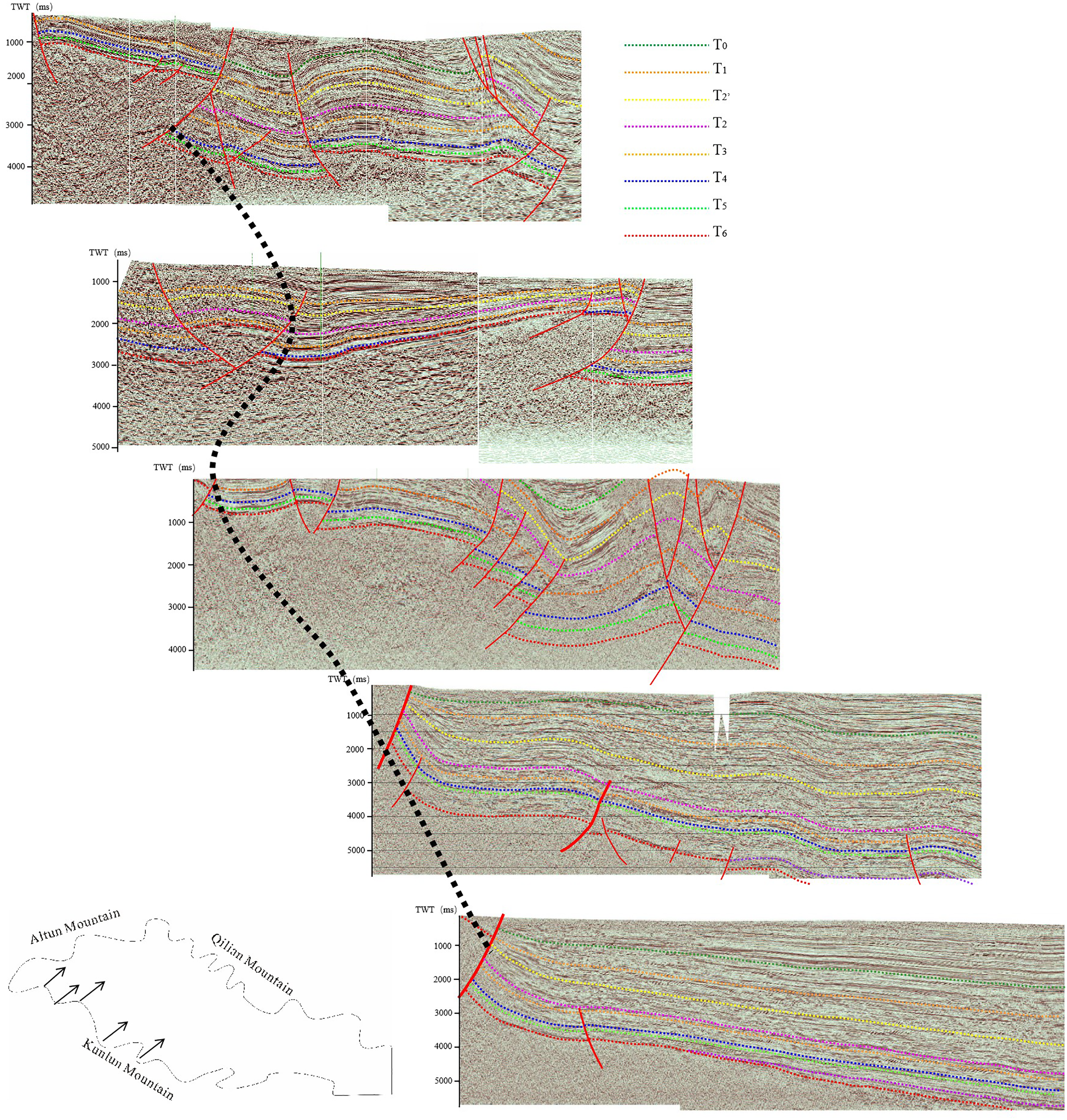
Joint profiles in the front of the Kunlun Mountains.
The imbalance of structural activities in the Qaidam Basin
The structural activities in the Qaidam Basin vary in time and space. More specifically, the nature and intensity of the tectonic activity are different across regions and periods, and the nature and intensity of the tectonic activity are also distinct.
In general, the intensity of the tectonic activity in the basin-mountain junction is greater than that in the interior of the basin, while the intensity of the tectonic activity in the western part of the basin is greater than that in the eastern part. Furthermore, the intensity of late activity is greater than that of early activity.
In addition, the tectonic activity intensity in the margin exceeds that in the hinterland of the basin. This is reflected in the development scale and activity intensity of the fault. For the large basin margin faults, the scale, intensity, and duration of fault activity are much more severe than those in the basin as shown in Figure 8. In front of the West Kunlun Mountains, there is a thrust step-like uplift structure, which is uplifted step by step toward the Kunlun Mountains through several growth thrust faults, with a maximum fault displacement of 5.5–6 km. From the Yingxiongling to Kunlun Mountains, the range of uplift reaches nearly 10,000 m. In front of the West Qilian Mountains, there is also a thrust step-like uplift structure with a maximum fault displacement of 5 km and an overall uplift of 13 km. However, in the basin, the scale and intensity of the fault development are obviously reduced, and the fault displacement becomes smaller.
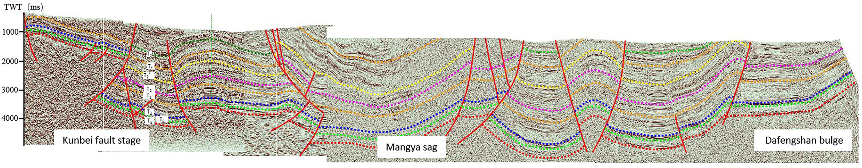
CFM-200 seismic profile of the Qaidam Basin (see Figure 1 for the section location).
The tectonic activity is greater in the western part of the basin than in the eastern part. Figure 9 presents a section in the front of the Kunlun Mountains from the west to the east of the basin. Several large, stepped faults developed in front of the Kunlun Mountains in the western part of the basin, with the lower faults reaching the base and the upper faults reaching the surface. The violent activities lasted for a long period of time, with a large vertical fault displacement and a long horizontal extension distance. Further to the east of the basin, the intensity of the tectonic activity was significantly weakened, and the relationship between the basin and mountain changed significantly, from thrust fault steps to developing faults in the lower part and slopes in the upper part. The hinterland of the basin also exhibits the same change trend. In the Yingxiongling structural belt in the west, three phases of tectonic activities were present, from the early northward basement-involved thrust, to the medium-term reverse imbricated thrust, and then to the late detachment thrust This not only reflects intense tectonic activity, but also multistage movement in the west. However, in the east, only one period of tectonic activity was observed, with a concentric anticline structural style, indicating that the tectonic activity was not only late, but also weaker than that in the west
Joint seismic profiles from the west to east of the Qaidam Basin.
The tectonic activity in the late stage of the basin is stronger than that in the early stage. From the evolution of structural activities in the Qaidam Basin, the intensity of the Qinghai–Tibet Plateau uplift has increased since the Cenozoic era. First, the unconformity between the Mesozoic and Cenozoic existed in the whole basin. The strata under the unconformity are strongly denuded, while the two late stages of unconformity are locally developed and show angular unconformity at the edge of the basin. Second, from the perspective of the sedimentation rate, the sedimentation amplitude in the late period became significantly larger (Figure 10). The growth faults show the same characteristics, and the late activity intensity increased significantly. ]Moreover, the development of a large number of late faults in the Qaidam Basin also indicates that the late tectonic activities were frequent and intense.
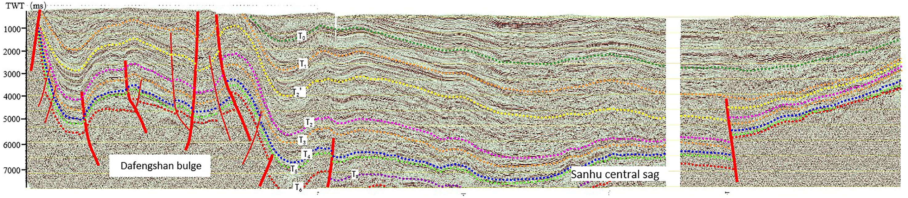
CDM-1089 seismic profile in the Qaidam Basin (see Figure 1 for section location).
Uplift control of the Qinghai–Tibet Plateau on hydrocarbon accumulation in the Qaidam Basin
The uplift of the Qinghai–Tibet Plateau plays an important role in controlling the hydrocarbon generation of the Qaidam Basin. The depression produced by the strong tectonic movement during the uplift provided space for the development of the lacustrine basin, which deposited the source and reservoir rocks necessary for hydrocarbon accumulation. Many faults and unconformities with different trends, properties, and sizes provide transport channels for hydrocarbon accumulation. The tectonic belts formed in rows and belts provide space for hydrocarbon accumulation. In particular, the uplift of the Qinghai–Tibet Plateau controls the formation of the Qaidam Basin, the structure and deposition of the basin, the formation of various reservoir-forming elements and their spatial–temporal matching relations, and ultimately the hydrocarbon accumulation and distribution in the basin.
Control of hydrocarbon generation centers
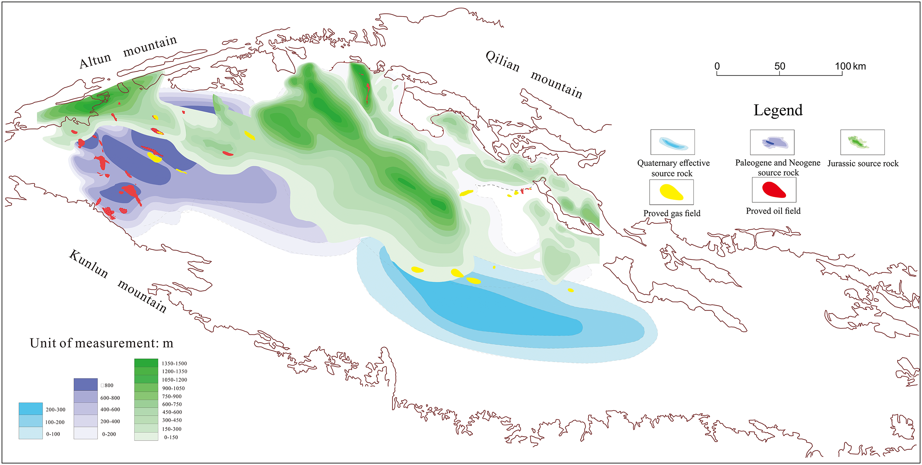
Qaidam Basin is rich in oil and gas resources, and there are three hydrocarbon-generating stoves in the Jurassic freshwater lacustrine facies, the Paleogene salt water lacustrine facies, and the quaternary salt lacustrine facies. The spatial distribution of the three hydrocarbon-generating stoves is controlled by the uplift of the Qinghai–Tibet Plateau. The three major hydrocarbon source rock stoves generally include three types of hydrocarbon source rocks: the limited salt lake facies hydrocarbon source rocks in the western part of the Qaidam Basin; the residual Jurassic hydrocarbon source rocks in the north margin of the Qaidam Basin to the Altun Mountains; and the widespread salt lake biological gas source rocks in the east of Qaidam. The presence of multiple types of source foci that do not overlap on the plane can be attributed that the uplift of the Qinghai–Tibet Plateau from the west to the east, which caused the structural activities of the Qaidam Basin to shift from the west to east and the formation of the depositional subsidence center as shown in Figure 11. This subsequently controlled the development of source rocks and the transfer of hydrocarbon generation center from west to east as shown in Figure 12. The western zone of the basin is Paleogene-Neogene source rock in western Qaidam Basin, and the eastern area is Quaternary gas source rock. The hydrocarbon source rocks in the west of the Qaidam Basin are mainly saline lake basin facies of the upper section of the lower Ganchaigou Formation (E32) and the upper Ganchaigou Formation (N1).The kerogen type of the Upper section of the lower Ganchaigou Formation source rocks in the lower Ganchaigou Formation of Paleogene is sapropelic (I–II1), with an average Total organic carbon (TOC) of 0.99%. The hydrocarbon generation potential of pyrolysis is more than half of S1 + S2, exceeding 10 mg/g, and is mainly mudstone, marl, and calcareous mudstone. With the exception of the local layers and sags, the thermal evolution degree is in the peak period of oil generation and the hydrocarbon conversion rate is high, which is the main source rock of the basin (Fu, 2010; Zhang et al., 2017). In the early period of the Himalayan movement, the tectonic movement in the west of the basin was greater than that in the east, and that in the south was greater than that in the north. Therefore, the development of this set of source rocks was very limited, and was only distributed an area of approximately 2000 km2 in the southwest of the basin. With the gradual migration of the sedimentary center to the northwest and southeast in the late Neogene, the quality of the hydrocarbon source rocks in this area gradually deteriorated and essentially disappeared in the middle of the Himalayan movement. The Quaternary gas source rock, which is concentrated in the Sanhu area, mainly developed in the Quaternary Qigequan Formation and is one of the main gas source rocks in the basin. It is generally composed of lacustrine mudstone, with an average TOC of 1.49% and an average pyrolysis hydrocarbon generation potential (S1 + S2) of 1.26 mg/g (Li, 2015). The distribution of this set of hydrocarbon source rocks has a clear boundary with the Paleogene hydrocarbon source rocks in western Qaidam, which reflects the uplift and migration of the basin during the Himalayan period. Moreover, due to the weak activity intensity in the eastern zone of the Himalayan basin, this set of hydrocarbon source rocks not only has a wide distribution area (about 20000 km2), but also a large thickness of effective hydrocarbon source rocks (up to 800 m) (Shuai et al., 2010). Due to the uplift of the Altun and Qilian Mountains, Jurassic residual coal measure hydrocarbon source rocks developed along them in the northwest of the basin. Three key lithologies are present: Middle-Lower Jurassic (J1-J2) mudstone, with an average organic carbon content of 2.59%, and average hydrocarbon generation potential (S1 + S2) of 5.31 mg/g; Middle Jurassic (J2) oil shale, with an average organic carbon content of 27.3%; and average hydrocarbon generation potential (S1 + S2) of 133.56 mg/g; and Middle Lower Jurassic (J1-J2) coal, with an average organic carbon content of 51.4%, and average hydrocarbon generation potential (S1 + S2) of 44.35 mg (Fu et al., 2010; Tian et al., 2018; Zhai et al., 2013). This set of hydrocarbon source rocks is also widely distributed, close to 2000 km2, but less distributed in the southwest zone of the basin, which is closely related to the strong and sustained tectonic activity during the western Himalayan movement. Due to the uplift of the Altun and Qilian Mountains, Jurassic residual coal measure source rocks developed along them in the northwest of the basin, Paleogene Ganchaigou Formation salted lacustrine source rocks are mainly developed in the southwest of the Basin, and Quaternary salt lacustrine source rocks are mainly developed in the eastern Qaidam Basin. The three sets of source rocks do not overlap in space, and correspondingly form three hydrocarbon generation centers. Around the three hydrocarbon generation centers, a gas-based oil-gas system with a Jurassic coal measure strata as the main source rock was formed in the northwestern area of the Qaidam Basin, and an oil-dominated petroleum system with Ganchaigou Formation salty lacustrine sedimentary strata as the main source rock was formed in the southwestern zone of the Qaidam Basin. In the eastern Qaidam basin, three petroleum systems with quaternary as the main source rock and biogas as the main source rock were formed (Figure 13).
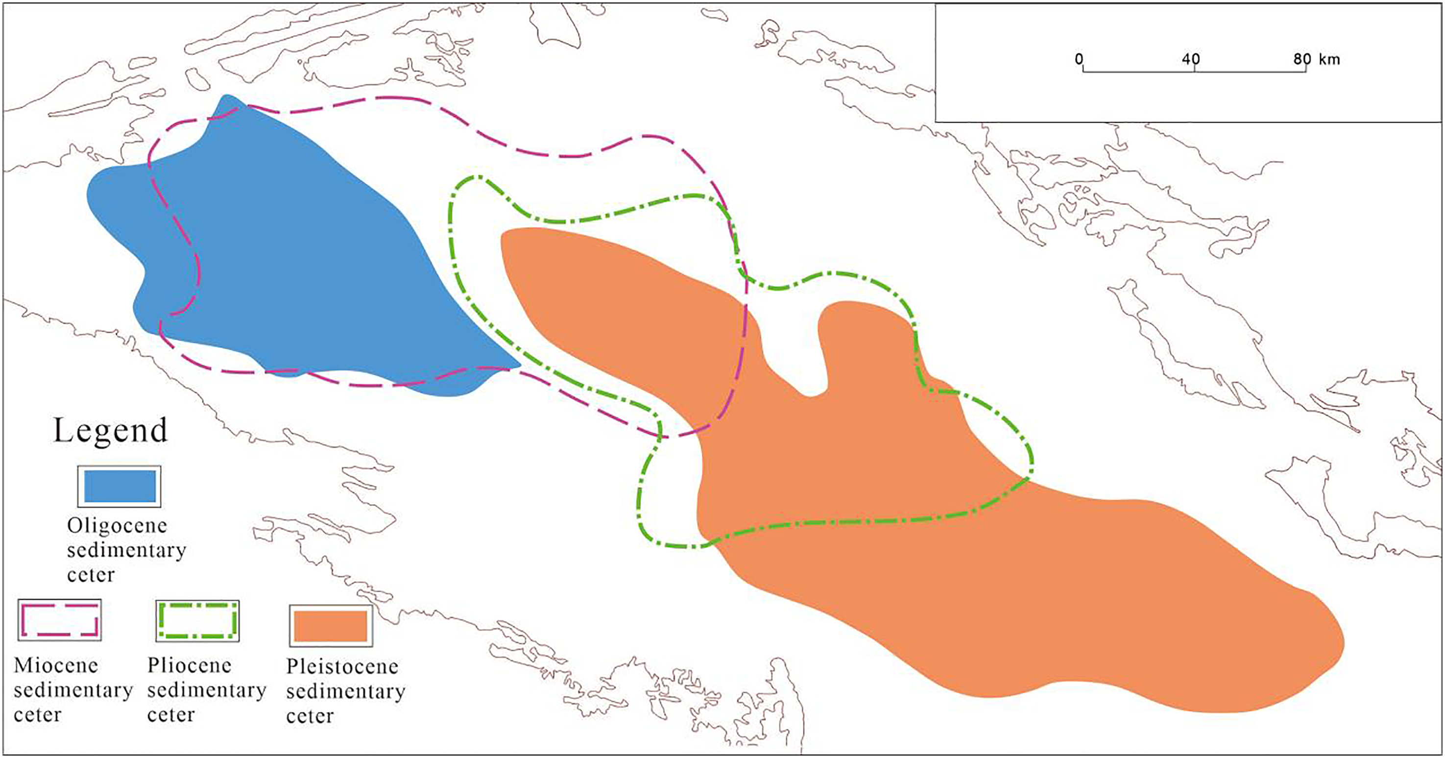
Schematic diagram of the migration plan of the Cenozoic sedimentary center in the Qaidam Basin (modified according to Pan et al., 2015).
Schematic diagram of the migration profile of the Cenozoic sedimentary center in the Qaidam Basin (from PetroChina Qinghai Oilfield Company, 2006, internal data modification).
Map of the three major hydrocarbon-bearing systems in the basin (modified according to Chen et al., 2019; Fu et al., 2015).
Control of hydrocarbon formation
The stages and imbalances of the uplift of the Qinghai–Tibet Plateau determine the stages and imbalances of the structural activities of the Qaidam Basin. The characteristics of this movement determine the development of different structural styles, transport systems, trap types, and the spatial and temporal matching of numerous reservoir-forming elements in distinct areas, tectonic units, and zones of the Qaidam Basin. In the basin, a variety of accumulation modes have been formed, such as the syngenetic thrust uplifting fault step accumulation mode in front of the Kunlun Mountains, the multistage superimposed relay uplift accumulation mode in the southwestern zone of the Qaidam Basin (Figure 15), and the late thrust uplift reservoir-forming mode and late uplift concentric anticline reservoir-forming mode in the front of the Altun Mountains.
The late tectonic activity since the subduction and collision of the India-Eurasia plate has a direct control effect over the accumulation period of large petroleum-bearing basins in western China (Zhao et al., 2005). The Qaidam Basin, the only large petroleum-bearing basin in the Qinghai–Tibet Plateau, was directly controlled by the uplift of the plateau during the main accumulation period. The uplift period exhibits a good corresponding relationship with the three main accumulation elements of hydrocarbon formation, circle, and migration in different areas of the Qaidam Basin. The plateau uplift not only directly controls the main accumulation period of the basin, but in the late stage. Taking the southwest region of the Qaidam Basin as an example, late N21 and late N23 are two critical periods for oil and gas accumulation as shown in Figure 14, among which the N21 period is the main formation period of early primary oil and gas reservoirs. In addition, the N23 period is the key period for late oil and gas reservoirs and early oil and gas reservoirs to be adjusted and reformed to form secondary oil and gas reservoirs. During the N21 period, most of the source rocks of the lower Ganchaigou Formation reached or approached the hydrocarbon generation threshold and began to generate and expel hydrocarbons. At this time, the plateau uplift controlled the formation of early traps and fault transport systems, providing a channel for the first phase of oil and gas transport and filling. During the N23 period, the hydrocarbon source rocks in the upper part of the lower Ganchaigou Formation and the upper Ganchaigou Formation both reached the hydrocarbon generation threshold, generating and expelling a large amount of hydrocarbons.
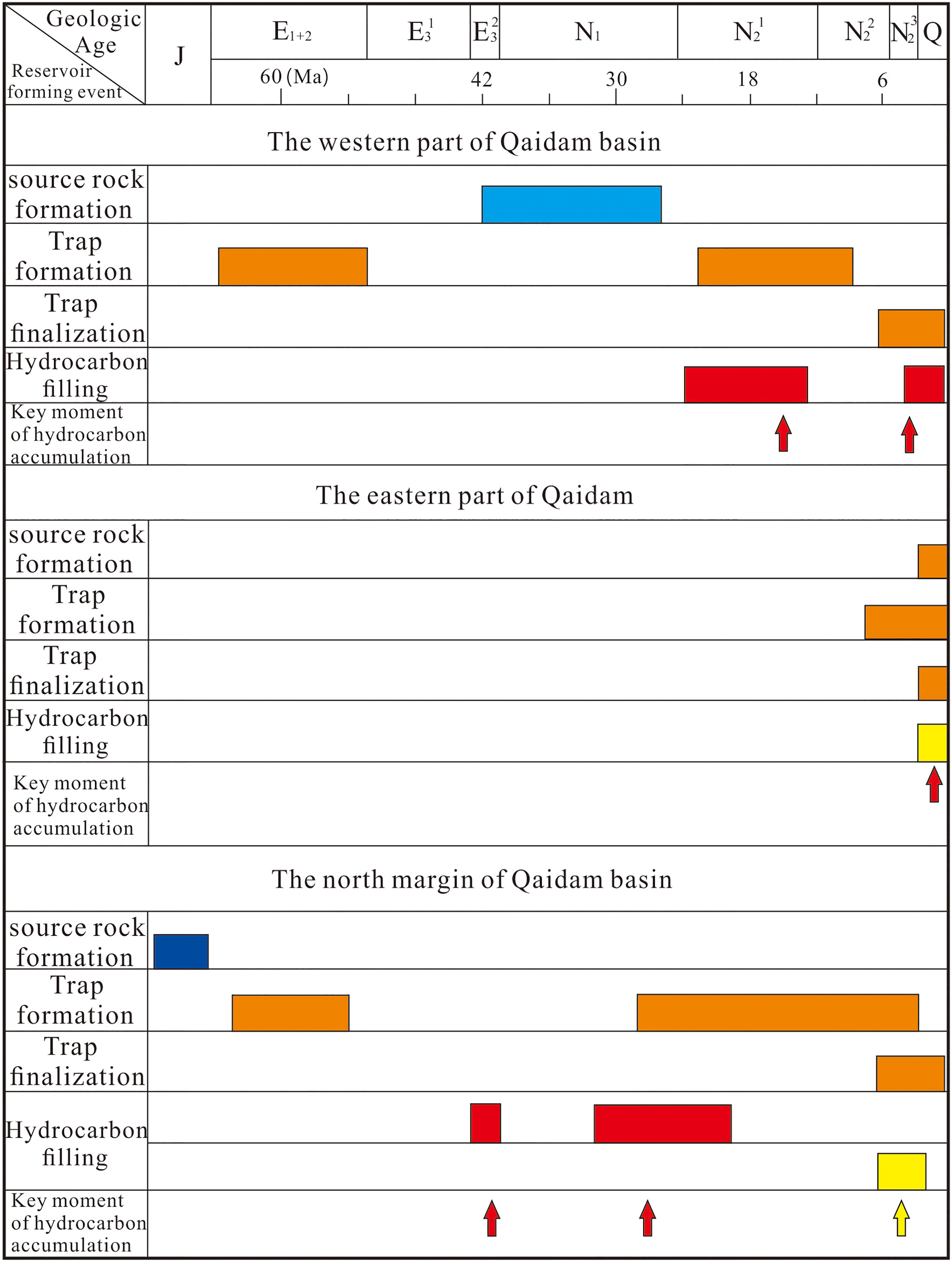
Key points in time of oil and gas accumulation in the basin.
At this time, the late uplift of the Qinghai–Tibet Plateau controlled the formation of late faults and the activation of the preexisting faults, providing a transporting channel for the late generation of oil and gas. Furthermore, the late uplift of the plateau also controlled the formation of late traps, and a large number of early traps were adjusted and finalized in this period, providing accumulation space for the large-scale enrichment of oil and gas generated in the late period. The end of N23 to the beginning of Q can be said to be the most important time for oil and gas accumulation in southwestern Qaidam. In the eastern Qaidam region, which is less affected by tectonic movements, the key stages of reservoir formation are from 1.5 Ma to current times, and are characterized by super late reservoir formation (Cao et al., 2013), with a late structural finalization period (Guo et al., 2012). It can be seen from the oil and gas system map of the western, eastern and northern margin areas of the Qaidam Basin that the uplift stage of the Qinghai–Tibet Plateau controls the main reservoir-forming stages in different regions, while the structural migration controls the distribution of other elements such as the source, reservoir, and sphere.
Control of oil and gas distribution
The distribution of oil and gas in the Qaidam Basin exhibits a regularity. The distribution pattern of the oil and gas reservoirs that have been discovered thus far reveal is obviously controlled by hydrocarbon generation centers, large faults of different types, and large anticline structural belts in rows and zones (Figure 15). In contrast, the development of hydrocarbon-generating centers, large faults, and numerous large anticlinal structural belts are controlled by the dynamic environment of different uplift stages of the Qinghai–Tibet Plateau.
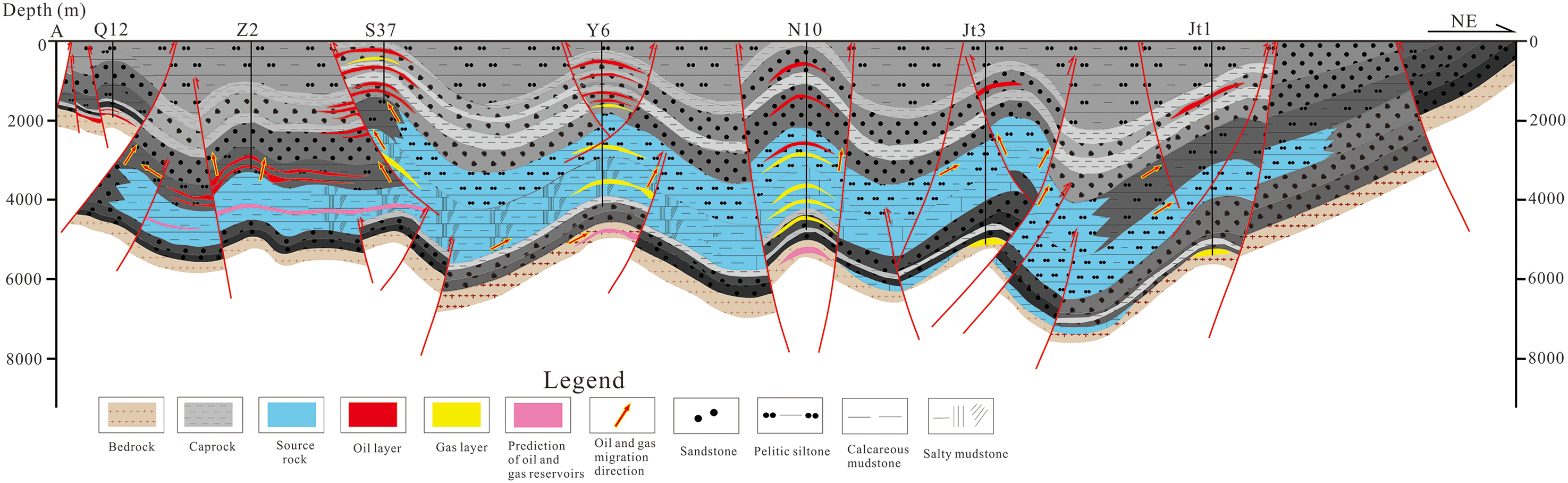
Accumulation pattern in the front of the Altun Mountains in the western zone of the Qaidam Basin.
First, the distribution of oil and gas is controlled by the hydrocarbon generation center. From Figure 13, it can be seen that the three major hydrocarbon generators control the distribution of oil and gas, and the reservoirs are all distributed in or around source rocks. The oil and gas produced during the Mesozoic are mainly distributed in the former eastern section of the Altun Mountains and the western section of the Qilian Mountains in the northwestern zone of the Qaidam Basin. The oil and gas generated in the Paleogene and Neogene are concentrated in the southwestern region of the Qaidam Basin. Quaternary biogas is generally observed in the Sanhu area in the east-central part of the basin. Second, oil and gas are distributed along large faults of different types, properties, trends, and periods. As can be seen from Figure 13, among the three major petroleum systems, oil and gas are mainly distributed along large fractures such as Alar, Kunbei, Yingxiongling, Jiandingshan, Dongping, and Maxian, forming oil and gas accumulation belts along major faults in different strike directions. Third, the distribution of oil and gas is controlled by large anticlinal structural belts. During the uplifting process of the Qinghai–Tibet Plateau, under the strong compressive stress, large structural belts formed in rows, belts formed in the basin, and many anticlinal traps developed, providing space for oil and gas accumulation and the subsequent formation of multilayer complex oil and gas accumulation zones.
Discussion
Late tectonic activity since the subduction collision of the India-Eurasia plate has had a direct control on the reservoir formation period of large hydrocarbon-bearing basins in western China (Zhao et al., 2005). The main reservoir formation period of the Qaidam Basin, as the only large hydrocarbon-bearing basin on the Tibetan Plateau, was directly controlled by the plateau uplift, suggesting that the whole hydrocarbon system in the study area requires reconceptualization. The evolution of basin tectonics has obvious stages, and the most latest structural activities should be the most critical controlling factor for hydrocarbon accumulation. The Qaidam Basin is surrounded by three mountains, and the extensive hydrocarbon enrichment in the piedmont thrust belt is the most important hydrocarbon distribution characteristic of the foreland basin. At the junction of the Kunlun and Altun Mountains in the basin, adjacent to the respective piedmont tectonic belts, oil and gas are obviously controlled by the first and second rows of the piedmont fault zones. Close to the interior of the basin, the late uplifted and strongly strike-slip Altun Mountains play a more dominant role in controlling its hydrocarbon distribution. As a large regulating fault on the northeastern margin of the Tibetan Plateau, the Altun Mountains began a large-scale left-slip movement during the Oligocene, that is, the middle stage of the Himalaya Orogeny, and the strike-slip displacement was as long as 420 km. A series of near-north–south regulating faults were also formed in the oil-rich depression southwest Qaidam Sag. At this time, the Kunlun Mountains were mainly vertically uplifted, which had minimal influence on the internal position of the basin at the junction. This is specifically reflected by the fact that most of the near north–south faults cut the NW-SE faults parallel to the Kunlun Mountains. At present, the majority of the oil and gas reservoirs are located in the southwest region of the Qaidam Basin and are enriched on both sides of these north–south faults.
Oil and gas in the southwestern zone of the Qaidam Basin are characterized by overpressure accumulation. We found that boiling inclusions developed in the Cenozoic reservoirs in this area, indicating that natural hydraulic fracturing or fault openings were caused by an abnormally high pressure in geological history. The primary reservoirs distributed in the abnormally high-pressure area presented “pulse” accumulation to the normal pressure zone due to the sudden change of temperature and pressure conditions. Fluid inclusion homogenization temperature measurements (Liu et al., 2007) reveal that two key phases of oil and gas infill occurred in the southwestern zone of the Qaidam Basin during the early Pliocene and late Pliocene to Quaternary, respectively, with the second infill phase being larger than the first This rapid transport and filling of hydrocarbons fully reinforce the ability of the staged uplift of the Qinghai–Tibet Plateau to generate sufficient power to drive hydrocarbon migration and accumulation.
Conclusions
Three regional unconformities are found on seismic profiles in the Qaidam Basin, coinciding with the three phases of the Himalaya Orogeny. The growth index of two large faults in the basin also exhibits obvious three-stage characteristics. The structural activities in the Qaidam Basin can be divided into three stages, coupled with the episodes of the Himalaya Orogeny. The three different stages of the tectonic evolution led to the formation of thrust imbrication in the middle and deep layers, and detachment structures in the shallow layers.
Structural activities shifted from the south to the north, from the west to the east, and from the basin margin to the basin interior during the Cenozoic. More specifically, the early stage thrust faults mainly occurred along the basin margin while structural activities within the basin generally began in the N22-N23 periods at the end of the Cenozoic era. The deformation was more active along the basin margin than in the basin interior, stronger in the western zone of the basin than in the eastern zone, and strengthened in the late Cenozoic.
The spatial–temporal variation of structural activities in the Qaidam Basin controls the transfer of hydrocarbon generation centers in the Qaidam Basin, forming three sets of main hydrocarbon source rocks that do not overlap in space. The long-active faults at the basin margin control the distribution of hydrocarbon resources. The late-stage large-scale structural traps of the basin are the main factors controlling oil and gas accumulation.
Footnotes
Declaration of conflicting interests
The author(s) declared no potential conflicts of interest with respect to the research, authorship, and/or publication of this article.
Funding
The author(s) disclosed receipt of the following financial support for the research, authorship, and/or publication of this article: This work was supported by the forward-looking and basic major scientific and technological project “Research on formation mechanism, reservoir forming conditions and resource potential of condensate and light oil” (grant number 2021dj0603) of China National Petroleum Corporation and Petroleum Corporation Science and Technology Cooperation Project of the CNPC-SWPU Innovation Alliance and the National Natural Science Foundation of China (grant numbers 42202176 and 2020CX050103).