
Abstract
The basement gas reservoir in the Dongping field in the Qaidam Basin is a large reservoir that is different from other basement reservoirs around the world. The basement reservoir does not contain thick mudstone with abundant organic matter that acts as both a source rock and a caprock. The natural gas came from lateral Jurassic source rocks. The basement lithologies in wellblocks Dp3, Dp1, and Dp17 are granite, granitic gneiss, and limestone with slate, respectively, but they all provide effective reservoir space for gas accumulation. The average porosities are 3.3%, 5.2%, and 3.6%, respectively, and the average permeabilities are 0.66 mD, 0.60 mD, and 0.57 mD, respectively. Tectonic fractures are the main factor for improving the physical properties of the reservoir, and secondary solution space is the key factor for the high and stable gas production in the study area. The E1 + 2 Formation, which contains abundant anhydrite, unconformably overlies the basement rock. Some of the anhydrite was deposited as cement and filled the fractures and pores, which led to decreased porosity and to the formation of a tight caprock with a high breaking pressure for hydrocarbon accumulation. The caprock becomes thinner from the lowland to the uplift, and it is missing in wellblock Dp3, which led to the heterogeneous distribution of gas. Anhydrite-bearing caprock is the dominant factor that controls the gas accumulation in the basement rock reservoir in the Dongping field. Studying the spatial distribution of the anhydrite-bearing caprock is important to the exploration and development of basement gas reservoirs in the Qaidam Basin. This unique gas accumulation mechanism in a basement rock reservoir may inspire new ideas for exploring basement oil and gas reservoirs around the world.
Keywords
Introduction
It is generally recognized that sedimentary basement that mainly consists of dense and hard Precambrian metamorphosed rocks have poor characteristics for hydrocarbon accumulation. However, with the increasing demand for energy, basement rock reservoirs, which are unique type of oil and natural gas reservoir, have become important targets for exploration around the world. Hydrocarbons within igneous and metamorphic rock reservoirs have been discovered in many parts of the world (Chen et al., 2011; Cuong and Warren, 2009; Feng, 2008; Hawlander, 1990; Koning, 2003; P’An, 1982; Schutter, 2003; Seemann and Scherer, 1984; Sircar, 2004). Most basement reservoirs have been recognized on platforms or in intermontane basins, and they are unconformably overlain by sedimentary sequences. They usually occur on highs or are associated with mountain uplifts (Harris et al., 2002; Nelson et al., 2000; Landes et al., 1960). Basement rock reservoirs, in which hydrocarbons are produced from the older metamorphic and igneous rocks, are far less common than conventional petroleum and gas reservoirs, which are generally composed of sedimentary rocks such as sandstone and carbonates (Munz et al., 2002). Basement rocks are typically very complex, hard, and solid with multiple lithologies. However, alteration of reservoir space can be caused by long-term uplift and the formation of folds that results in weathering, leaching, crumbling, decomposition, solution, erosion, and strong tectonic movements, which can generate many inhomogeneous fractures and secondary solution pores (Alikarami et al., 2013; Hall et al., 2012; McCaffrey et al., 2003; McKinley and Warke, 2007; Schutter, 2003; Tiercelin et al., 2004; Vincent et al., 2013). The various effects of weathering on basement rocks control the vertical distribution of reservoir physical properties. The porosity and permeability generally decrease with increasing distance from the top of the weathered crust (Chen et al., 2016a). However, drilling in the basement rock reservoir in the Liaohe Depression in China showed that the effective reservoir depth can reach, 1600 m (Song et al., 2011). Fractures are ubiquitous in crystalline rocks and are usually clearly observed on the surface of drilling cores. They control the rock strength and fluid transport, and two or more fracture systems can contact multiple oil-water or gas-water zones (Koning, 2003). High porosities and permeabilities are likely associated with tectonically induced fractures because such fractures can significantly increase the permeability (Heap and Kennedy, 2016; Nara et al., 2011). The development of fractures can give rise to secondary porosity around them because flow mainly occurs in fractures, which creates more effective reservoir space in the basement rocks and allows the diffusion and flux of hydrocarbons in the basement rock (Ismar de Souza et al., 2013).
Walters (1953) and P’An (1982) recognized that oil and gas migration occurs locally into the porous systems in basement rocks from the overlying rocks or from the flanks of each uplift. A basement reservoir can form when oil and gas are transported to structural highs or uplifts within the basin. However, regardless of the type of basement reservoir, a cap rock is often the most important factor for hydrocarbon accumulation (Han, 2006; Ma et al., 2015). Most basement hydrocarbon reservoirs that have been discovered worldwide underlie lacustrine mudstone, which acts as both a source rock and a good cap rock, as in the Panhandle field in America and the Bach Ho field in Vietnam (Areshev et al., 1992; Ismar de Souza et al., 2013).
The exploration of oil and gas reservoirs in the basement rocks in China has progressed substantially in recent years with the discovery of basement reservoirs in the Jiuquan Basin, Bohai Bay Basin, Liaohe Basin, Qaidam Basin, and Santanghu Basin (Li, 2007; Li et al., 2014; Ma et al., 2015; Wu et al., 2001; Zhang, et al., 2007; Zhao, 1998). The Qaidam Basin experienced the strong Cenozoic Himalaya Orogeny, which resulted in a complex structure, and the source-reservoir-cap assemblage of the hydrocarbon reservoirs were deformed intensively during that period (Fu et al., 2012). The basement reservoirs that have been discovered worldwide mainly produce oil with either a small amount of gas or no gas at all (Ma et al., 2006; Yang and Xu, 2011). In 2012, a large basement gas reservoir was discovered in the Dongping field in the Qaidam Basin (Guo et al., 2016; Li et al., 2014; Ma et al., 2015). This discovery represents a new and important finding in unconventional natural gas resources exploration in the Qaidam Basin. Recent exploration has shown that the basement rocks in the Dongping field are very complex with multiple lithologies and are not overlain by dense mudstone that is rich in organic matter. The hydrocarbons were transported by deep fractures from lateral Jurassic source rocks (Cao et al., 2013a, 2013b; Ma et al., 2015). The anhydrite-bearing mudstone caprock in the Lulehe (E1 + 2) Formation overlying the basement rock ensures abundant natural gas accumulation in the Dongping field, which is different from other large basement rock reservoirs around the world. The main purpose of this study is to investigate the characteristics of the basement rock reservoir, the overlying caprock and the entire storage and sealing system of this unique basement accumulation. The results are expected to improve the understanding of the characteristics and formation mechanisms of this kind of large gas reservoir in basement rocks.
Geological setting
The Qaidam Basin, a typical plateau inland basin, is located in the Northern Tibetan Plateau in northwest China. It is an important hydrocarbon-producing basin and covers an area of approximately 120,000 km2. It has an irregular rhombus shape and is bordered by the Altun Mountains to the northwest, the Kunlun Mountains to the south and the Qilian Mountains to the northeast (Figure 1). Spatially, the basin comprises three tectonic units, namely, the northern fault-block belt, the western depression, and the eastern depression. The eastern depression is the most important structural unit for the development of hydrocarbon source rocks. The basin contains crystalline basement and Mesozoic-Cenozoic sequences of lacustrine sediments, which are affected by high-angle conjugate reverse faults (Chen et al., 2012; Clark et al., 2010; Ke et al., 2013). The Dongping field is located east of the Altun Mountains. The tectonic evolution of the Altun Mountains can be divided into three stages: (1) faulting in the Early Yanshan Orogeny, which led to extensional rifting in the Mesozoic; (2) a fault depression in the Early Himalayan Orogeny, which led to the pull-apart of the Lulehe and Upper Ganchaigou Formations and the formation of a paleoslope in the Dongping area; and (3) structural inversion in the Mid-Late Himalayan Orogeny, which was the depression stage of the Upper Ganchaigou and Lower Youshashan Formations, and a paleo-uplift formed during this phase (Cao et al., 2013a). This sequence of events formed the present structural configuration of the Dongping field.
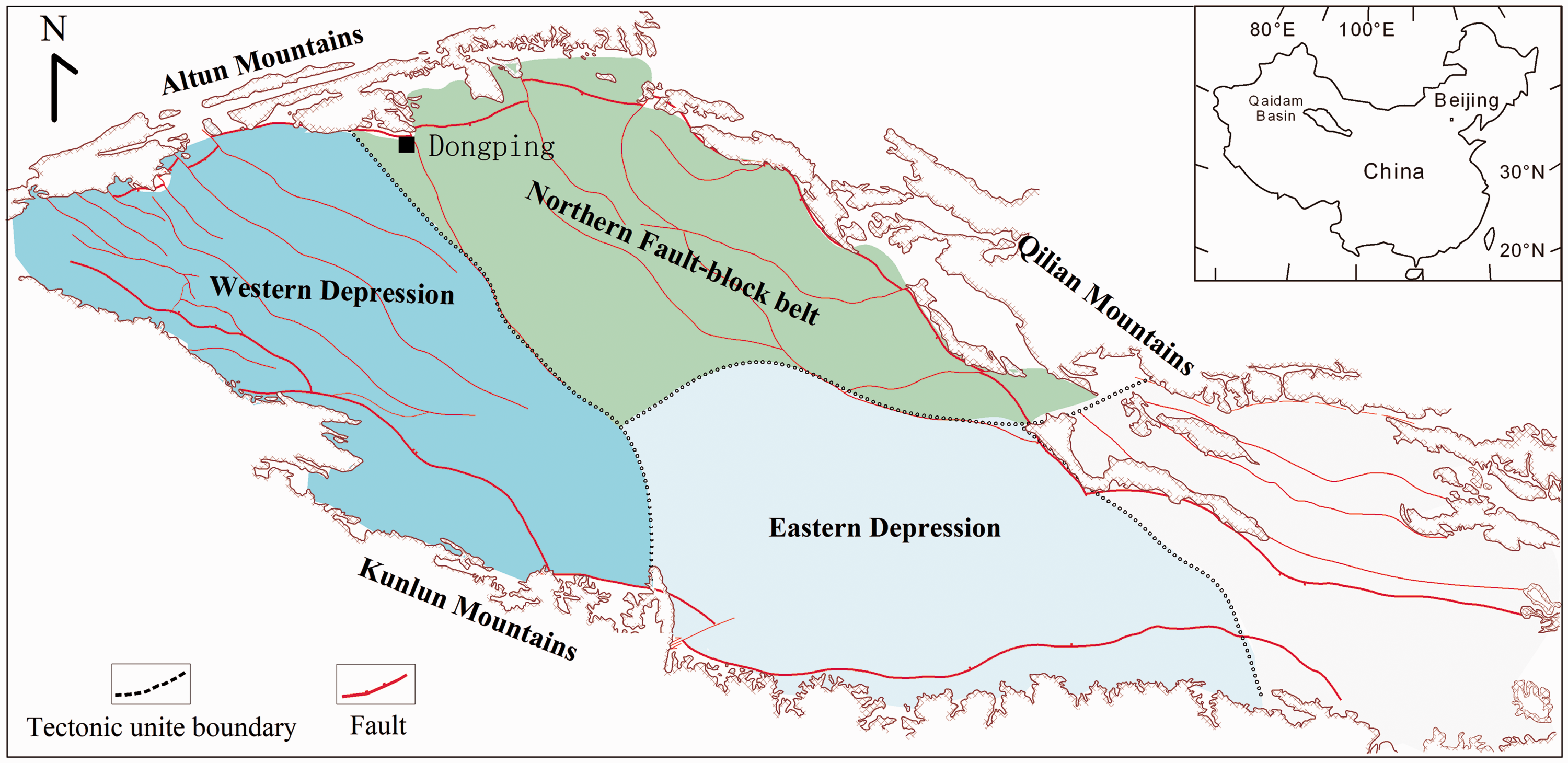
Map showing the geographic location and structural units of the Qaidam Basin and the location of the study area.
The main deposits in the front of the Altun Mountains are Jurassic, Paleogene and Neogene strata. They thin gradually and are structurally uplifted towards the mountains, and the shallow layers in local uplifts or piedmont zones have been significantly eroded and influenced by recent tectonic movements. From oldest to youngest, the stratigraphic units in the Dongping area are crystalline basement, the Lulehe Formation (E1 + 2), the lower member of the lower Ganchaigou Formation (E31), the upper member of the lower Ganchaigou Formation (E32), and the upper Ganchaigou Formation (N1) (Figure 2). During the period of the deposition of E1 + 2 Formation in Paleocene-Eocene, the Early Himalayan Orogeny began with the uplift of the Altun Mountains, and alluvial fan and braided river developed with a suite of red coarse clastic rocks including sandy conglomerate, sandstone, siltstone, mudstone, and anhydrite interlayers. From the period of E3 to N1, the lake range was widened and tectonic movements were reduced. The grain size distribution in sediment was that mudstone and silty mudstone dominated.
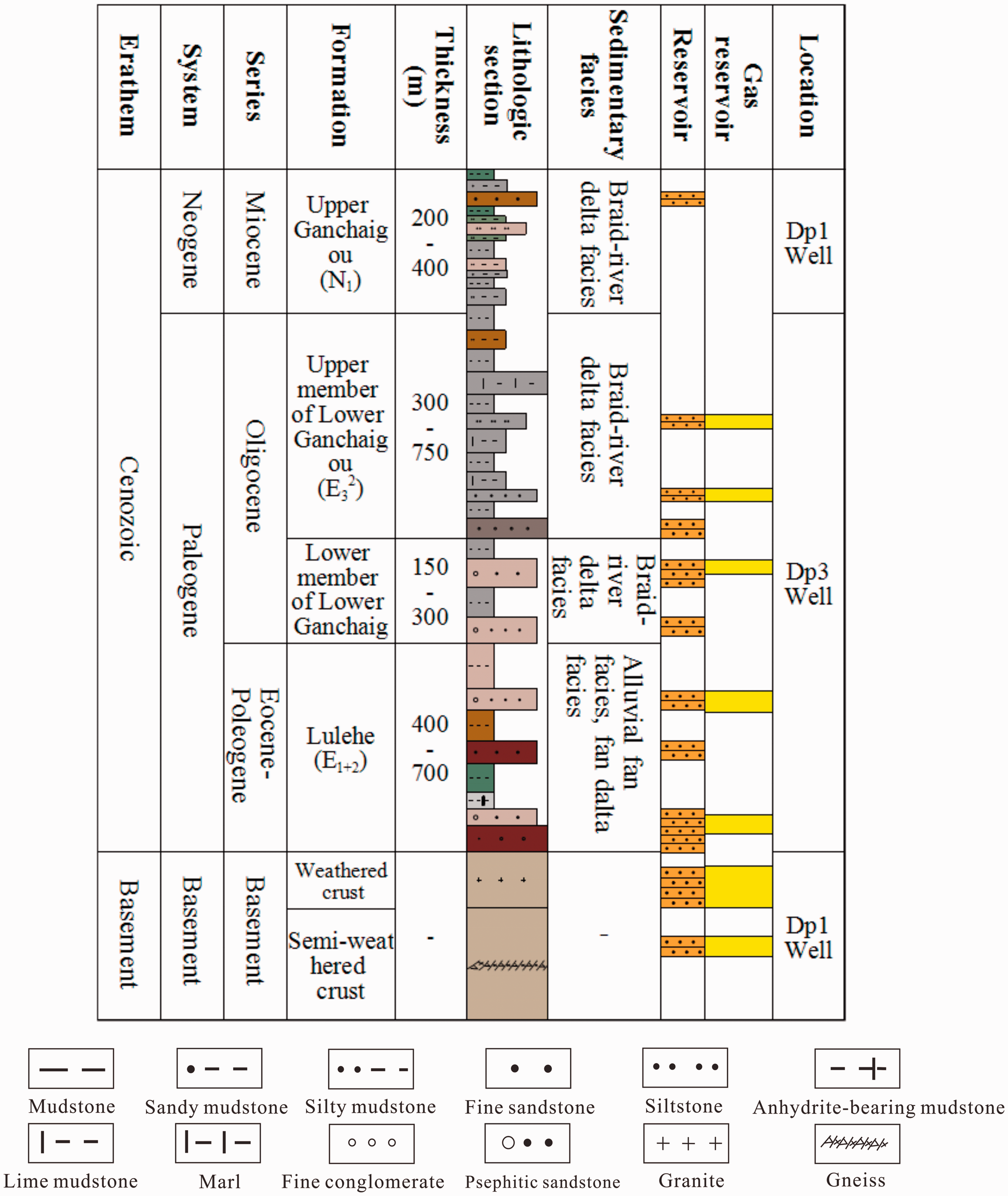
Stratigraphic column of the Dongping area in the Qaidam Basin showing the distribution of oil and gas strata and major lithologies.
The Jurassic hydrocarbon source rocks on the northern margin of the Qaidam Basin are mainly Type II2-III that generated gas and a small amount of oil. A hydrocarbon-generation thermal simulation experiment using samples of the Jurassic hydrocarbon source rocks showed that the total gas production rate is 1017.6 m3/t at 500°C, and the production rates of CO2, hydrocarbon gas, and H2 are 466.1 m3/t, 376.8 m3/t, and 151.8 m3/t, respectively (Ma et al., 2015). The gas generation intensity in the major hydrocarbon-generation sags reaches 200 × 108 m3/km2, which indicates strong gas generation capacity. Jurassic source rocks had not yet produced hydrocarbon until the end of E31 Formation. And by the end of N1 Formation, the source rocks began to generate natural gas in some areas with the vitrinite reflectance (Ro) higher than 1.2%. From the end of N22 Formation to the end of N23 Formation, thermal degree of the Jurassic source rocks was dry gas phase with the vitrinite reflectance (Ro) higher than 3.0%. During this period, present-structural had basically formed, and it was the main period of reservoir-forming of oil and gas. The activities of faults destroyed Jurassic paleo- reservoir but also connected Jurassic source rocks, which made a lot of oil and gas transport into structural traps and “buried hill” trap system (Cao et al., 2013a, 2013b). Because Jurassic strata are not present in the Dongping area, the E1 + 2 Formation unconformably overlies the basement rock. Unconformities also play an important role in basement reservoirs because they are the pathways for hydrocarbon migration. The basement rock reservoir space in the study area was formed by weathering and tectonic movement, and alteration caused by physical and chemical processes resulted in massive fractures and solution pores before oil and gas generated. A large volume of natural gas has been discovered in the basement rock reservoir, and the gas is believed to have originated from the adjacent Jurassic source rocks, which have a high organic matter content (Cao et al., 2013a, 2013b; Ma et al., 2015).
The Dongping paleo-uplift, which is a nose structure, is controlled by an N-S-trending fault and has a large south-dipping slope. The Dongping field consists of three gas pools from the front of the mountain towards the basin, namely wellblocks Dp3, Dp1, and Dp17 (Figure 3). Wellblock Dp3, which is located in the high fault-uplift zone controlled by a secondary fault in the northern part of the nose structure (Li et al., 2014). Wellblock Dp1, which is located on the slope in the eastern part of the nose structure, is a fault anticline that is controlled by a reverse fault. Wellblock Dp17 is located at a lower structural position near wellblocks Dp3 and Dp1 in the southwestern part of the nose structure.
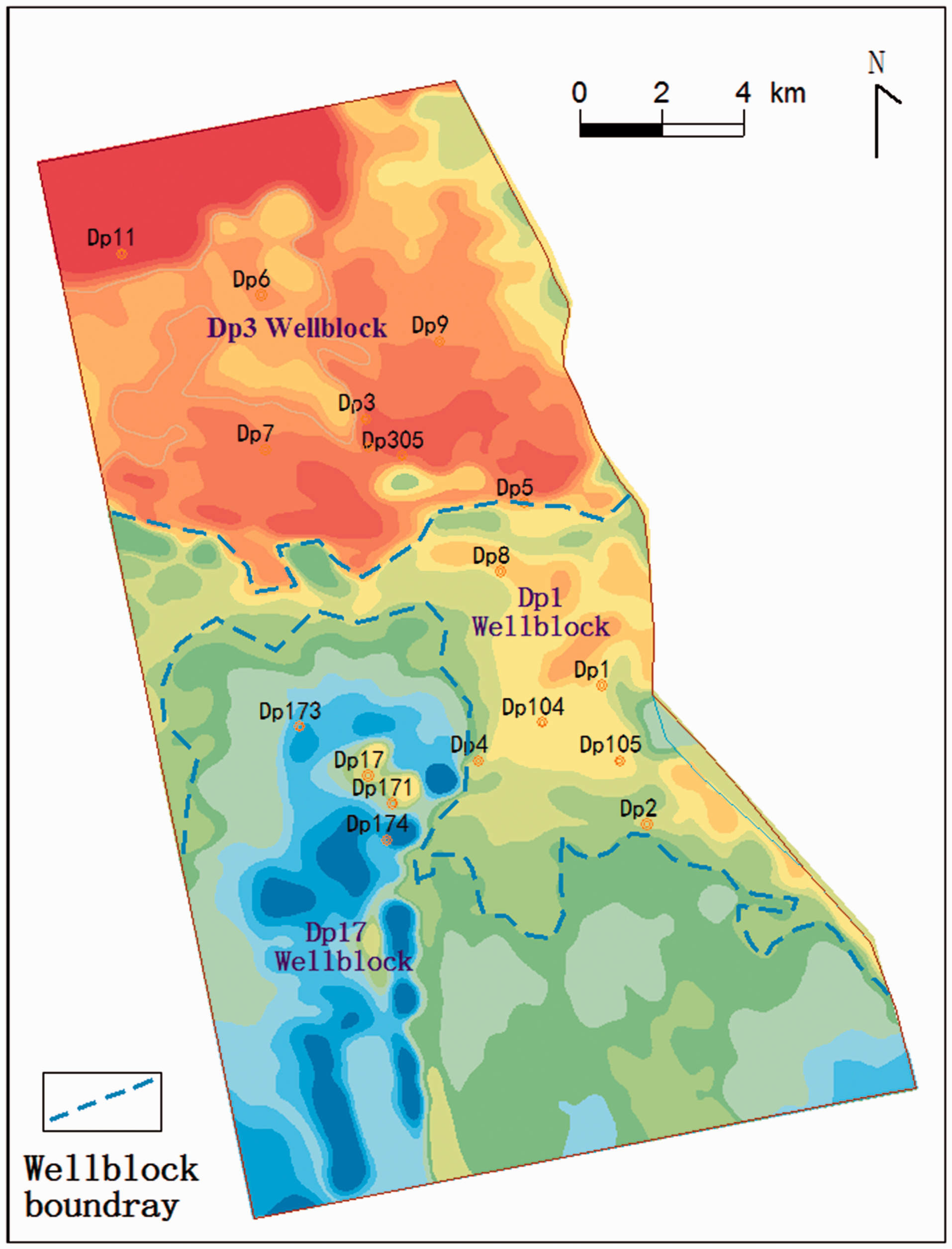
Pre-sedimentary paleotopography of the E1 + 2 Formation and partitioning of the three wellblocks in the Dongping area.
Methodology
Numerous basement samples were collected from well cores from the three wellblocks in the Dongping field and analyzed. The samples were collected from sixteen wells: five wells drilled in wellblock Dp3, eight in wellblock Dp1, and three in wellblock Dp17. The analytical methods included log identification, X-ray diffraction, electron microscopy, field emission scanning electron microscopy, effective porosity, pulse-decay permeability, breaking pressure, and nuclear magnetic resonance (NMR).
The micro-morphology and mineral compositions of 92 samples were examined by visual observation of the cores, thin section observation with optical microscopy, field emission scanning electron microscopy, and X-ray diffraction. Approximately 300 points were counted in thin sections using the point counting method of Gazzi-Dickinson (Ingersoll et al., 1984). A Rigaku D/maxrA12KW rotating anode X-ray diffractometer with Cu K-alpha radiation (40 kV, 100 mA) was also used to identity mineral compositions. Stepwise scanning measurements were performed at a rate of 4°/min in the range of 3°–85° (2ϴ). These analyses were carried out at the Key Laboratory of Reservoir Description, Northwest Branch of PetroChina Exploration and Development Research Institute (NWGI).
A total of 60 samples were measured for effective porosity and permeability with a PoroPDP-200 automated permeameter-porosimeter. The samples were made into cylinders 3 cm long and 1.5 cm in diameter. The pulse-decay permeameter-porosimeter can determine porosity and pore volume at overburden pressures up to 70 MPa with helium. The effective porosity values were calculated with Boyle's law and ranged from 0.01% to 40%. The equivalent air permeabilities at a user-specified pressure were also calculated and ranged from 0.001 mD to 10,000 mD. Four anhydrite-bearing mudstones in Dp1 and Dp17 wellblock were measured for pore-size distribution by NMR. These analyses were carried out at the Key Laboratory of Reservoir Description, NWGI.
The PetroChina Qinghai Oilfield Company has conducted extensive oil and gas drilling in the Dongping field, and large numbers of experimental analyses have been performed. These data are available in this study. The measurements of the breaking pressures of the samples containing anhydrite were conducted by the Key Laboratory of PetroChina Qinghai Oilfield Company.
Reservoir characteristics
Types and compositions of basement rocks
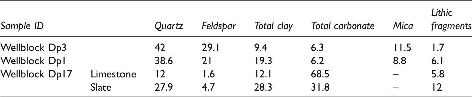
The basement rocks in the study area are either dark gray or gray in the core. However, different lithologies are found in the basement rock reservoir in the three wellblocks (Table 1). Wellblock Dp3 is located in a high fault-uplift zone with more steeply dipping and intensively denuded strata, and the main lithology is granite. Thin section identification and X-ray diffraction whole-rock analysis show that the mineral components of the rocks in this wellblock are stable clastic ingredients with the most common detrital grains comprising 34.2–46.9% quartz (average of 42%), 17–40% feldspar (average of 29.1%), 6–17% mica (average of 11.5%), 3.5–11.5% clay minerals (average of 9.4%), 0–12% carbonate minerals (average of 6.3%), and 0–3.6% lithic fragments (average of 1.7%), including pyrite and anhydrite (Table 1). The granite has a medium-grained granitic texture and a massive, partially banded structure (Figure 4(a)).
Average mineralogical compositions of the basement rock samples in different wellblocks.
Photomicrographs of thin sections of basement rocks in different wellblocks in the Dongping area. (a) Granite; dark-colored minerals have variable alteration, 1881.5 m, well Dp301 in wellblock Dp3. (b) Granitic gneiss, gneissic structure, 3230.91 m, well Dp103 in wellblock Dp1. (c) Slate, platy structure, 4558.1 m, well Dp17 in wellblock Dp17.
Wellblock Dp1 is located in the slope zone, and the main lithology is granitic gneiss. The main mineral components of the rocks in this wellblock are 20.1–62.3% quartz (average of 38.6%), 2.6–51.9% feldspar (average of 21%), 3.0–32.9% clay minerals (average of 19.3%), 1–15% mica (average of 8.8%), 0–11.3% carbonate minerals (average of 6.2%), and 0–17.4% complex lithic fragments (average of 6.1%), including augite, barite, hornblende, pyrite, and anhydrite. The granitic gneiss is medium- to coarse-grained. Quartz and feldspar form the light-colored layers in the grain structure, and hornblende and biotite form the dark layers. The granitic gneiss in wellblock Dp1 has an obvious gneissic structure (Figure 4(b)).
Wellblock Dp17 is located in a downfaulted area between wellblocks Dp3 and Dp1 and contains interbedded slate and metamorphic limestone. The X-ray diffraction results show that calcite is the dominant mineral in the gray limestone with a content of 61.1–77.8% (average of 68.5%), and the limestone also contains small amounts of quartz (average of 12%), clay minerals (average of 12.1%), and lithic fragments. The limestone contains obvious schistose structures. The main mineral components of the gray black slate are 23.3–36.2% clay minerals (average of 28.3%), 25.8–31.2% quartz (average of 27.9%), 27.4–36.1% calcite (average of 31.8%), and 4.9–13.5% lithic fragments (average of 12%), including barite, pyrite, and anhydrite. These minerals have platy structures (Figure 4(c)).
Reservoir space
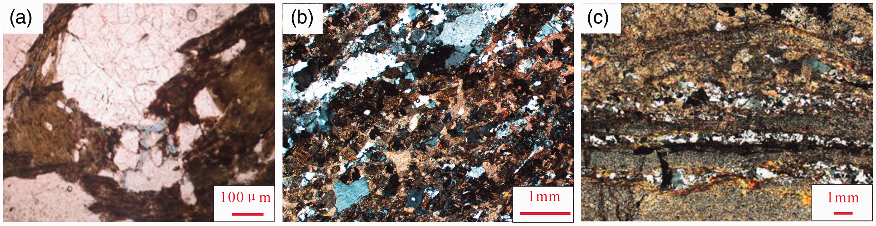
To assess the quality of basement rocks as potential hydrocarbon reservoirs, it is critical to identify the types of reservoir space. Core observations combined with thin section analysis and scanning electron microscope (SEM) imaging show that fractures form the main basement reservoir space in the Dongping area (Figure 5(a) to (c)). Fractures in basement rocks are generally the most important pathways for hydrocarbon migration and storage (Ismar de Souza et al., 2013), and they are one of the most important factors affecting basement rock reservoirs. The basement rocks in the Dongping field have undergone severe alteration over long periods of time as a result of strong tectonic movements, weathering, denudation, leaching, and dissolution processes, which allowed numerous multistage tectonic fractures and dissolution fissures to form in every orientation and in shallow to deep basement zones. Dissolution fissures with irregular edges that originated from tectonic fractures are well developed in the three wellblocks (Figure 5(d) to (f)). Different extended high-angle shearing fractures are widely developed in wellblocks Dp3 and Dp1. The fractures identified by SEM imaging in wellblock Dp3 are wider than those in wellblock Dp1 (0.03–1.346 mm wide), and individual fractures can be more than 5 mm wide. The fractures in the granitic gneiss in wellblock Dp1 are generally 0.03–0.175 mm wide, and individual fractures can be more than 2 mm wide. The fractures in wellblock Dp17 are mainly tension fractures that generally extend short distances either along the foliation or at different angles. They mainly have widths of 0.05–0.35 mm, and the widest is more than 2.5 mm wide.
Photographs of cores, thin sections, and scanning electron microscope (SEM) images of fractures and pores in basement rocks. (a) Fractures in granite in wellblock Dp3. (b) Fractures in granitic gneiss in wellblock Dp1. (c) Fractures in slate in wellblock Dp17. (d) Dissolution fissures developed along tectonic fractures, 1880.3 m, well Dp301 in wellblock Dp3. (e) Dissolution fissures and solution pores along tectonic fractures, 3229.61 m, well Dp103 in wellblock Dp1. (f) Dissolution caves along tectonic fractures, 4559.3 m, well Dp17 in wellblock Dp17. (g) Micropores in feldspar and ferromagnesium, 3244.4 m, well Dp103 in wellblock Dp1. (h) Intracrystalline pores between mica sheets, 3507.21 m, well Dp105 in wellblock Dp1. (I) Solution pores in limestone, 4342 m, well Dp17 in wellblock Dp17.
The pores in the study area include primary pores and secondary solution pores. The primary pores were formed after the vaporization of volatile matter from magma and crystallization, constriction and metamorphism. They are not completely filled with later deposits. These pores are mainly micropores with diameters of 200–800 nm (Figure 5(g)). However, some intercrystalline pores have developed between the mica sheets with diameters of up to 7 µm (Figure 5(h)). Secondary solution pores are dominant in the study area. Early weathering and dissolution contributed to the formation of the solution pores. One type of pores is distributed sporadically on the surface of soluble minerals and has a maximum diameter of approximately 2.5 µm (Figure 5(i)). The distribution of these pores is influenced by the connectivity between the pores and the direction of flow. The other type of solution pores is located around fractures, and they often form dissolution caves (Figure 5(f)). The development of dissolution caves is one of the controlling factors for high productivity and large reserves. Fracture development improves the connectivity of the cave-fracture system. These dissolution caves are controlled by the properties of the fluid inside the fractures.
Caprock characteristics
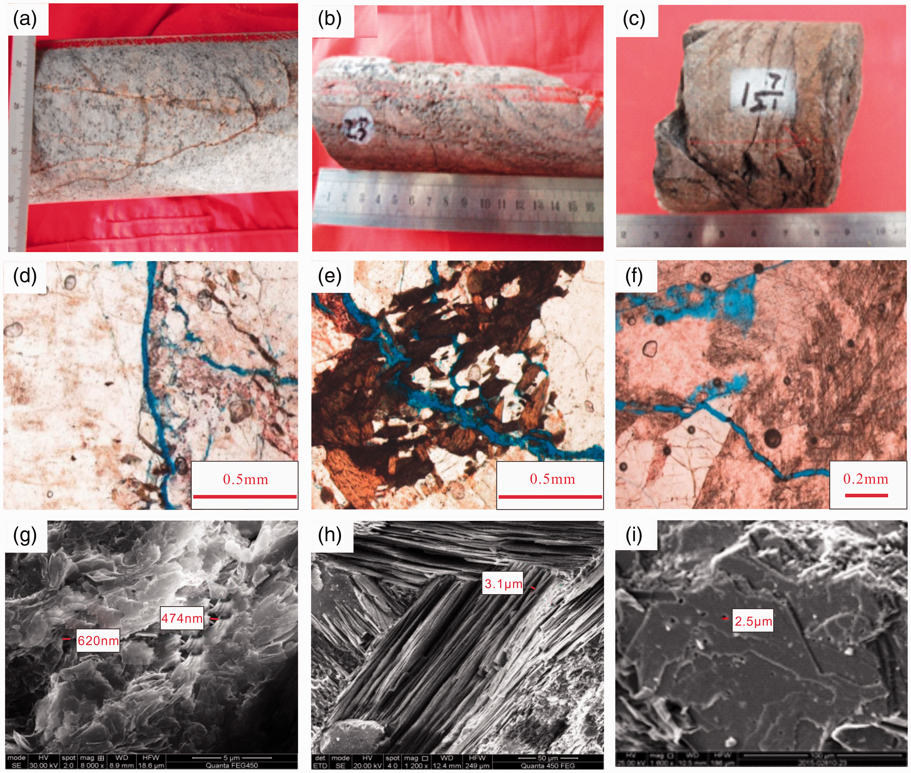
The E1 + 2 Formation overlies the basement rock reservoir and contains proximal coarse clastic sediments that are not typical of a caprock, but the lithologies vary rapidly with the changes in the narrow sedimentary facies belt. The major lithologies identified from the core observations are red-brown conglomerate and sandstone in the E1 + 2 Formation in wellblock Dp3. In wellblock Dp1, brown sandy conglomerate was deposited at the bottom of the E1 + 2 Formation, but the upper lithologies gradually transition to siltstone, sandy mudstone, argillaceous anhydrite, and anhydrite-bearing mudstone. In wellblock Dp17, the lithologies include brown mudstone, sandy mudstone, argillaceous anhydrite, and anhydrite-bearing mudstone. In the Dongping area, most of the gypsum has experienced dehydration and formed anhydrite that is usually grayish white in color. Anhydrite exists in two forms: clusters of lumps of anhydrite crystals (Figure 6(a)) and clastic anhydrite as cement that fills fractures and pores in the E1 + 2 Formation (Figure 6(b) and (c)).

Photographs of existing forms of anhydrite. (a) Clusters of lumps of anhydrite crystals in mudstone. (b) Anhydrite fill in fractures as cement in the upper part of the basement rock. (c) Anhydrite fill in pores as cement in the E1 + 2 Formation.
Anhydrite is identified by the log response combined with the core observations. The log curves of the anhydrite-bearing intervals show high electrical resistivity, high density, low gamma ray, low neutron porosity, and low interval transit time values (Figure 7). Anhydrite deposition differs greatly in different depositional environments. Salty water with abundant anhydrite flowed downwards, which led to small amounts of anhydrite being deposited in the sandy conglomerate and sandstone in wellblock Dp3, whereas large deposits of anhydrite in mudstone and even thinner anhydrite layers have been discovered in wellblocks Dp1 and Dp17 (Figure 8).
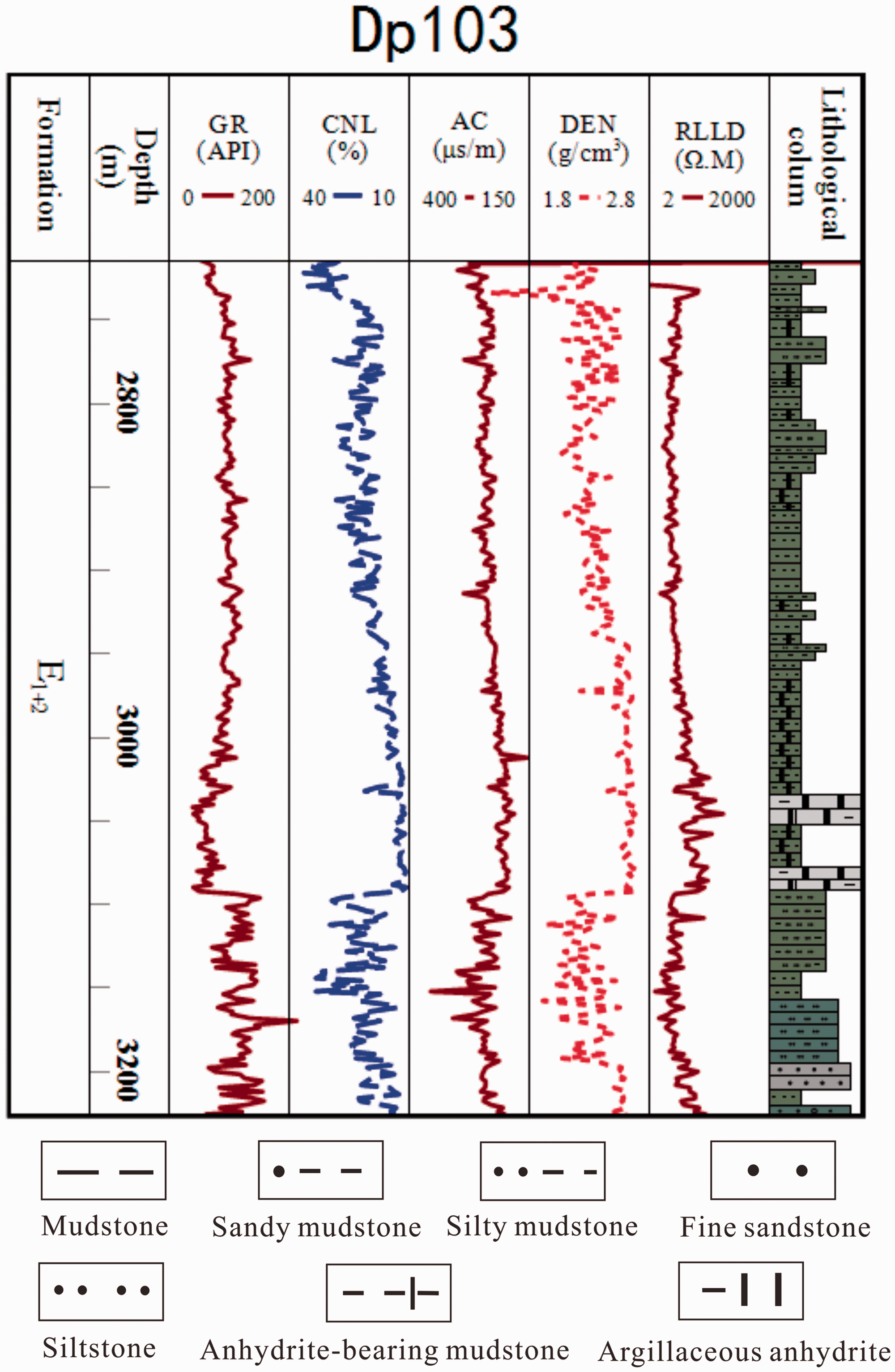
Log responses of anhydrite in the E1 + 2 Formation in well Dp103 in wellblock Dp1.
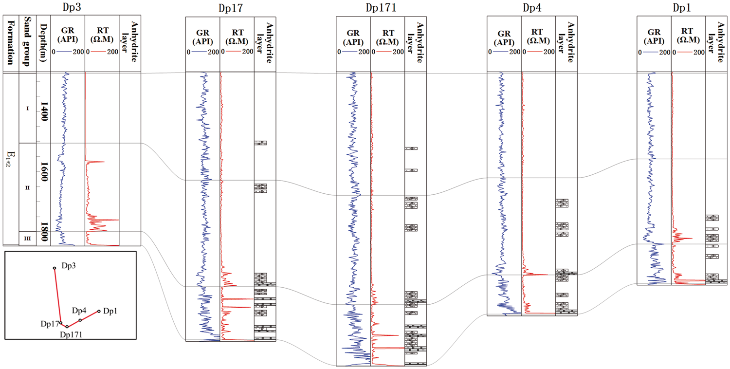
Distribution of anhydrite caprock in three sand groups of the E1 + 2 Formation in the three wellblocks in the Dongping field.
The E1 + 2 Formation is carefully divided into three sand groups (named I, II, and III from top to bottom) based on the lithological characteristics and electrical properties. The deposition of sand group III was affected by the paleotopography, and it gradually thins towards the mountains. The thickness variation in sand group III also shows that the paleotopography was formed before deposition of the E1 + 2 Formation, and it reflects the depositional processes of filling and leveling up in the early sedimentary stages of the E1 + 2 Formation. The sedimentary thickness of sand group III is thin and non-uniform, and it has a clear regional variation in the three wellblocks (Figure 8). The maximum thickness in wellblock Dp17 is approximately 200 m, and the average thickness is 160 m. The minimum thickness in wellblock Dp3 is less than 60 m, and the average thickness is 30 m. In contrast to sand group III, sand groups I and II are both massive and uniformly distributed with an average thickness of 300 m.
The caprock thickness is one of the most important factors in evaluating caprock efficiency (Timlin, 2009). The overall distribution of the effective caprock in the Dongping area is also studied by lithological identification combined with well log responses. The lithology of the caprock includes thick anhydrite-bearing mudstone and thin argillaceous anhydrite. The anhydrite-bearing caprock becomes thicker from the uplift to the lowland, and it is mainly located at the bottom of sand group II and throughout all of sand group III. The thickest area is in wellblock Dp17, which has a cumulative thickness of 76–155 m. The caprock becomes thinner in wellblock Dp1, which has a cumulative thickness of 35–112 m. Caprock that could effectively seal a basement reservoir is poorly developed with a small amount of anhydrite deposition in wellblock Dp3 (Figure 8).
Reservoir-caprock efficiency for gas accumulation
Petrophysical properties of reservoirs
Basement rock reservoirs are characterized by thick reservoir rocks with multiple lithologies (Koning, 2003; P’An, 1982), and weathered zones can generally contain matrix porosities of 5–10% (Nelson et al., 2000). The irregular porosity and permeability developed in basements can be induced by a combination of fracturing and mineralogical modifications (Areshev et al., 1992). The basement reservoir in the Dongping area is a typical weathering crust reservoir in which the reservoir space has been improved by physical weathering and chemical dissolution. The basement rocks in the core sections investigated in the three wellblocks are relatively heterogeneous. The fractures and pores identified by thin sections and SEM imaging are the dominant reservoir space in the basement rocks. The effective porosity and permeability of some of the samples were analyzed based on the different lithofacies in the three wellblocks by helium measurements. The results show that in wellblock Dp3, the effective porosity is less than 11%, and the permeability is less than 1.1 mD. In wellblock Dp1, the effective porosity is less than 9.6%, and the permeability is less than 0.8 mD, and the effective porosity and permeability in wellblock Dp17 are less than 7.2% and 1.0 mD, respectively. Changes in porosity in the basement become more difficult to observe with increasing depth (Chen et al., 2016a). The porosities of all of the basement rock cores were calculated with acoustic curves (Figure 9). The results show that in wellblock Dp3, the porosities are between 0.1% and 19.6%, and 25.6% of the porosities are greater than 10%. In wellblock Dp1, the porosities are between 0.1% and 18.8%, and 9.7% of the porosities are greater than 10%. In wellblock Dp17, the porosities are between 0.1% and 10.3%, and most are less than 8%. The data indicate that the granite in the uplift in wellblock Dp3 has better reservoir properties due to the stronger physical weathering and chemical dissolution, and the porosity gradually decreases towards the slope and low-lying area.
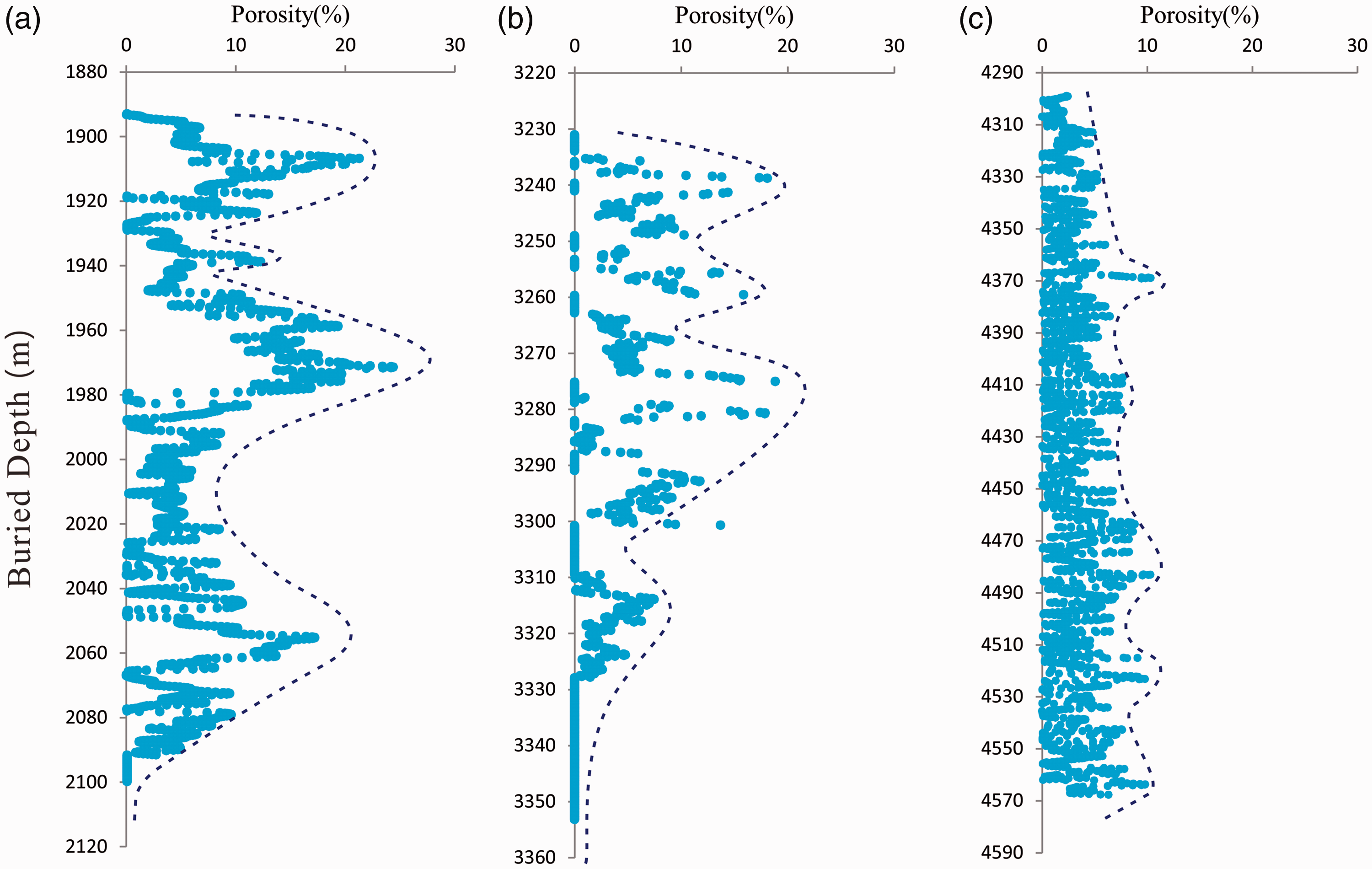
Distribution of porosity with increasing depth in the basement rock reservoirs. (a) Well Dp306 in wellblock Dp3. (b) Well Dp103 in wellblock Dp1. (c) Well Dp17 in wellblock Dp17.
Although the upper part of the basement rock underwent strong weathering and leaching, clay layers and anhydrite cementation formed in the fractures and pores. As poor reservoir physical properties developed in the upper part of the basement, it became a tight layer that could effectively prevent hydrocarbons from migrating upward. However, the porosity continues to increase with increasing distance from the top of the basement rock reservoirs. The porosity is best at depths less than 250 m due to the combined effects of tectonism, weathering, leaching, and mineralogical changes. The porosity in the basement rocks displayed a similar vertical trend in wellblocks Dp3 and Dp1 (Figure 9(a) and (b)). The cores showed a wide range of porosities, which is generally believed to be due to the contributions of fractures and secondary space that formed due to secondary alteration processes, such as tectonism, weathering, leaching, brittle deformation, grain dissolution, and metasomatism (Chen et al., 2016b; Schutter, 2003). Of these, tectonism and weathering are considered to be the dominant mechanisms for the formation of the secondary space in the basement rock reservoirs in the study area. In contrast, the different lithologies (granite and granitic gneiss) did not have a significant influence on the physical properties of the reservoir. The distribution of porosity in wellblock Dp17 is different from those in the other two wellblocks (Figure 9(c)). The variation in the porosity is small over the entire range of depths, and the maximum porosity is 10.3%. The short fractures and secondary solution pores are the main cause of the homogeneous porosity distribution. A comparison with the core data shows that all of the higher porosities developed in the limestone in the interbedded slate and limestone. Dissolution is favorable for secondary solution pores, and it thus forms the available reservoir space in limestone. Wu et al. (2015) analyzed the porosity of the basement rocks in the Dongping field with mercury injection experiments. They found that 38.3–76.6% of the porosity could not be accessed by liquid mercury but could be accessed by helium. These pores are called matrix micropores and have diameters of several to hundreds of nanometers. The fractures and pores both contributed to the effective reservoir space in the basement rock; in particular, the pores contributed to the effective space because they are the main reason for the stable and high yields of the gas reservoirs in the Dongping area. Though the lithologies in the three wellblocks are different, the total volumes of effective reservoir space for gas accumulation are similar. The key to the formation of the gas reservoir is the sealing efficiency of the upper caprock.
Caprock efficiency
The results of the core porosity and permeability analyses of the reservoir intervals of the E1 + 2 Formation in wellblocks Dp3 and Dp1 show that the porosity of the reservoir intervals in wellblock Dp3 ranges from 1.0% to 9.3% with an average of 3.6%. The permeability ranges from 0.05 mD to 6.7 mD with an average of 0.257 mD. The porosity of the reservoir section in wellblock Dp1 ranges from 4.0% to 8.0% with an average of 6.1%, and the permeabilities are distributed from 0.05 mD to 0.5 mD with an average of 0.453 mD. Although the reservoir in the E1 + 2 Formation is tight, it does not meet the sealing conditions for caprock over a large area. However, the caprock can effectively seal hydrocarbons where large deposits of anhydrite are present in the mudstone.
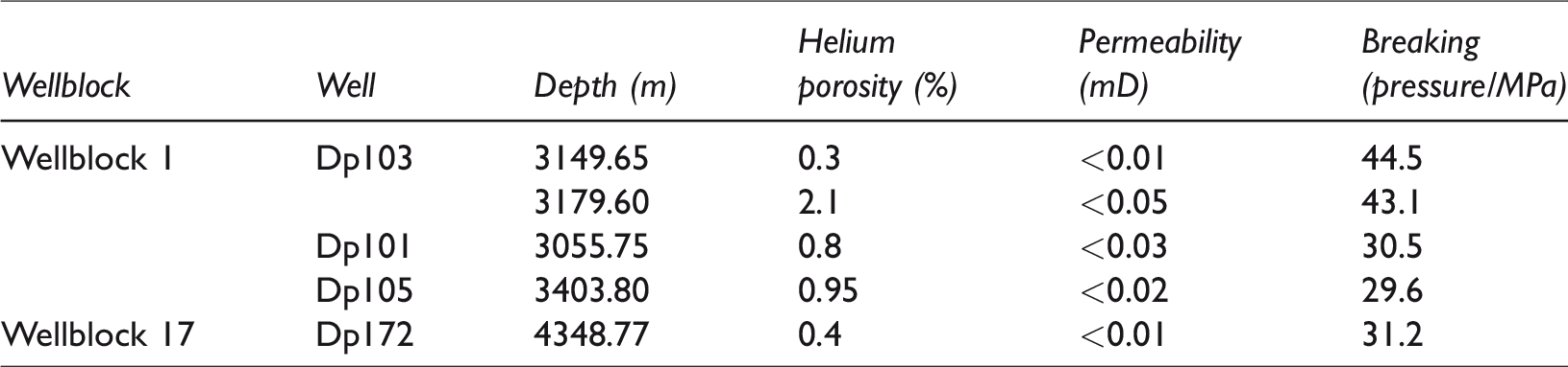
It is generally acknowledged that sedimentary systems are influenced by multiple factors, such as the structural evolution, climate, paleotopography, and provenance. The sedimentary fill in front of the Altun Mountains is controlled by the structural evolution and ancient climate conditions (Zou et al., 2015). The E1 + 2 Formation at the bottom of the Cenozoic strata was widely deposited in the Qaidam Basin from the Paleocene to the end of the Eocene, and the climate was likely relatively arid and semi-arid at that time (Zou et al., 2015). During this period, the arid and semi-arid climatic conditions and the salinization of lake water were favorable for the formation of anhydrite (Chen, 2007). The anhydrite deposits in the E1 + 2 Formation allowed natural gas to be sealed in the basement rock reservoir. The measured breaking pressure of anhydrite-bearing mudstone was from 29.6 MPa to 44.5 MPa (Table 2), with the low porosity and low permeability between 0.3%–2.1% and <0.05 mD respectively. More anhydrite deposited in the mudstone, lower porosity and permeability developed for the strong anhydrite cementation and tight caprock formed in the E1 + 2 Formation (Figure 6). The lower porosity and permeability were directly resulted from the small pore-size distribution in the compact mudstone. The NMR analysis results showed that the pore-size mainly distributed in 20 nm–1 µm in wellblock Dp1 (Figure 10(a) and (b)). The pore-size mainly distributed in 20 nm–1 µm and 10 nm–1000 µm in wellblock Dp17 (Figure 10(c) and (d)). The pore-size distribution curves showed that there was only one crest in the sample of wellblock Dp1, while there were two crests in the sample of wellblock Dp17. The first crests present the pore-size distribution in the compact anhydrite-bearing mudstone in wellblock Dp1 and Dp 17, and the second crests should be the diameter sizes of microfractures developed in wellblock Dp 17. As the limited number of usable mudstone samples, the data could not determine whether there are microfractures developing, nor their diameter sizes in the mudstone in wellblock Dp 1. However, the anhydrite-bearing mudstone with high breaking pressure and very low porosity and permeability in wellblock Dp 1 and Dp 17 belongs to Class I caprock according to the gas reservoir cap rock evaluation standard (Sun et al., 2008; Zhao and Yang, 1994).
Physical properties of the tight caprock in wellblock Dp1and Dp17 in the E1 + 2 Formation.
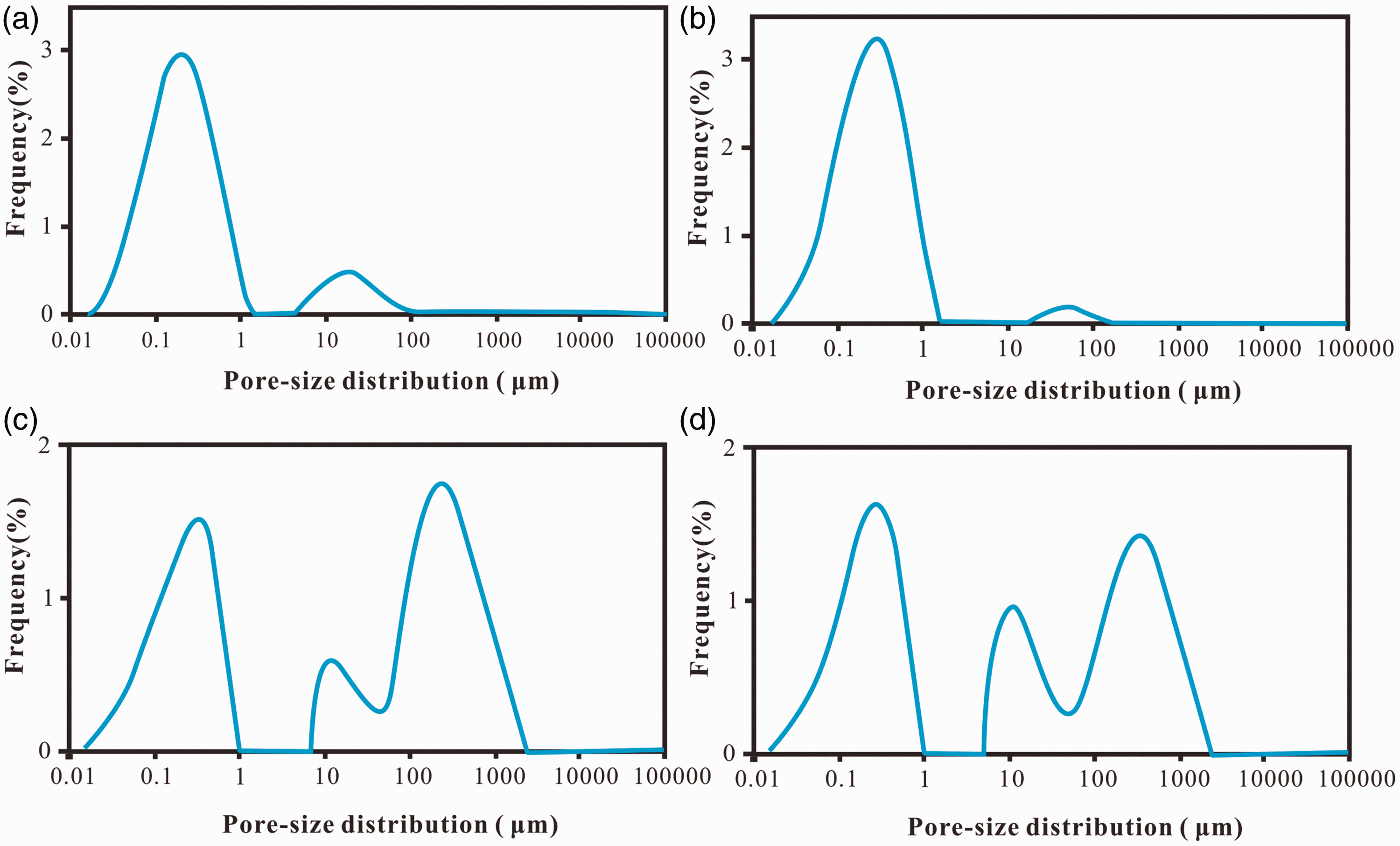
Pore-size distribution in tight anhydrite-bearing mudstone by NMR in wellblock 1 and wellblock 17. (a) Sample from well Dp 103 in wellblock Dp1, 3149.65 m, E1 + 2. (b) Sample from well Dp 103, 3179.60m in wellblock Dp1, E1 + 2. (c) Sample from well Dp 172 in wellblock Dp17, 4348.77 m, E1 + 2. (d) Sample from well Dp 171 in wellblock Dp17, 4308.34 m, E1 + 2.
Reservoir-caprock assemblage and gas distribution
A nearby source rock, significant transportation through deep fractures, effective reservoir space with fractures and a good caprock are the essential conditions for oil and gas accumulation in basement rock reservoirs (P’An, 1982; Walters, 1953; Yang and Xu, 2011). The thick and continuous Jurassic source rock has a high gas generating ability, and it is the main hydrocarbon source for the oil and gas reservoirs in the northern Qaidam Basin (Cao et al., 2013a; Ma et al., 2015). Though there are no hydrocarbon source rocks directly above the basement rock reservoir, the reservoir is close to hydrocarbon-generating depressions, and deep fractures connect the source rock to the basement, which led to abundant natural gas accumulations in the basement rock reservoir in the study area.
The E1 + 2 Formation unconformably overlies the basement rock. The unconformity system resulted from the paleo-weathering zone that experienced weathering, eluviation, dissolution, and transgression over geological time (Chang, 2006). The development and distribution of the unconformity surface controlled not only hydrocarbon migration but also the level of hydrocarbon enrichment. Moreover, the basement rocks in the study area have experienced the long-lasting effects of repeated exposure, which greatly improved the reservoir properties due to the formation of large numbers of tectonic fractures, dissolution fissures, dissolution pores, dissolution caves, and faults. The unconformity transports hydrocarbons through the porosity in the basement rocks and weathering-related fractures. It is the main pathway for the lateral migration of hydrocarbons. Fracture systems are the main pathways for the vertical migration of hydrocarbons in basement rock reservoirs. The core and the microscopic characteristics of the reservoir rocks in the study area strongly suggest that the tectonic fractures and solution pores caused by secondary alteration processes played key roles in the formation of effective gas reservoirs in the basement rocks.
Caprock is a crucial and sometimes overlooked factor in the evaluation of a potential hydrocarbon accumulation, especially in gas reservoirs (Hao et al., 2000). Even if a reservoir has good properties and is continuously replenished by source rocks, the caprock plays a more important role in controlling the abundance of hydrocarbons and their vertical distribution in basins (Tong and Niu, 1989). The abundant anhydrite deposited in the E1 + 2 Formation in the Dongping area was the result of a salty water environment and Ca2+ and SO42− from pre-Cenozoic limestone. However, the paleotopography and sedimentary environment controlled the deposition of anhydrite. Wellblock Dp3, which is located on the uplift, was unfavorable for anhydrite deposition in the shallow and turbulent sedimentary environment. Although a small amount of anhydrite was deposited in wellblock Dp3 when Ca2+ and SO42− were transported from the provenance region, most permeated into highly weathered sandstone and could not form anhydrite-bearing caprock. The Ca2+ and SO42− then flowed down the slope to the lower area, and some was deposited in the slope sediment (wellblock Dp1), while most of the rest was ultimately deposited in the lower area (wellblock Dp17), which had low energy water and a high clay content. The sedimentary characteristics of the anhydrite controlled the heterogeneous distribution of the anhydrite-bearing caprock and the gas accumulation.
Although the underlying basement rock reservoir and the overlying anhydrite-bearing caprock assemblage are temporally discontinuous, they contact in direct spatial (Figure 11). This kind of assemblage not only has wide-ranging contact but also has superior sealing ability for gas accumulation. The anhydrite-bearing caprocks were well developed in wellblocks Dp1 and Dp17. They formed excellent reservoir-caprock combinations with the underlying basement rock reservoirs, and they successfully prevented the upward migration of oil and gas (Figure 11). The properties of the basement rock reservoir in wellblock Dp3 are good, but the anhydrite-bearing caprock thins significantly towards the mountains and is even missing in wellblock Dp3. Therefore, gas could not be effectively sealed in the basement rock reservoir in this wellblock; it could migrate upward until it met the tight mudstone caprock in the Paleogene strata. The different lithologies in the basement rock reservoirs all have good properties, but the distribution of the overlying effective caprock varies in the different wellblocks in the Dongping field and affects the gas accumulation. To be effective, the extent of the anhydrite-bearing caprock overlying the basement rock reservoir is the key to exploring for large-scale basement gas accumulations.
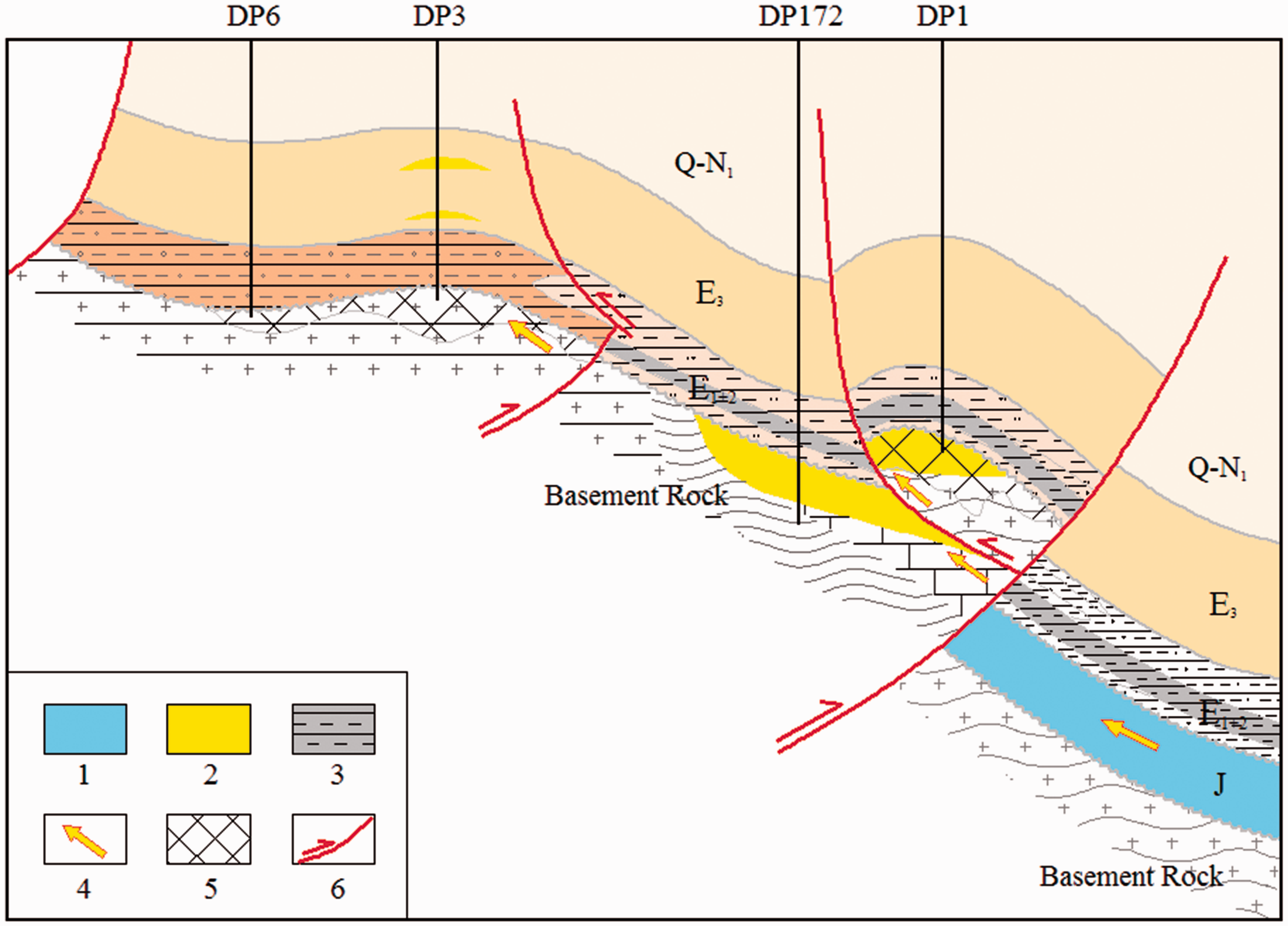
Schematic diagram of gas migration and accumulation in the basement rock reservoirs in the three wellblocks in the Dongping field. Wells Dp6 and Dp3 are in wellblock Dp3, well Dp172 is in wellblock Dp17, well Dp1 is in wellblock Dp1. 1. source rock; 2. natural gas; 3. anhydrite-bearing caprock; 4. gas migration; 5. weathered crust; 6. fault.
Conclusion
Most of the basement rock reservoirs that have been discovered around the world underlie thick mudstone with abundant organic matter, which acts as both a source rock and a good caprock. The large basement gas reservoir in the Dongping field is a unique type that is characterized by a lateral hydrocarbon source and an anhydrite-bearing caprock. However, not all of the basement rock reservoirs in the different wellblocks in the study area are enriched in gas and have high yields. The reservoir quality is controlled by the sealing ability of the upper caprock. The mudstone unit that contains anhydrite may form an excellent regional seal for the preservation of the hydrocarbon accumulation in the basement rock reservoirs.
The lithologies are different; wellblocks Dp3, Dp1, and Dp17 contain granite, granitic gneiss, and slate and metamorphic limestone, respectively. The effective basement rock reservoir space is formed by a combination of primary and secondary processes in these four lithologies. Tectonic activity, long-term weathering, denudation, and leaching improved the reservoir properties by forming numerous tectonic fractures, dissolution fissures, dissolution pores, dissolution caves, and faults. The porosity varies widely. The reservoir properties in wellblocks Dp3 and Dp1 are best within 250 m of the top of the reservoirs. The porosity is relatively evenly distributed in wellblock Dp17 due to the lithology. However, fractures and pores contributed similar total volumes of reservoir space for gas accumulation in the three wellblocks.
The abundant anhydrite that was deposited in the E1 + 2 Formation formed an effective caprock that sealed the natural gas in the basement rock reservoirs. The anhydrite-bearing caprock becomes thicker from the uplift towards the lowland. It is thickest in wellblock Dp17 and becomes thinner in wellblock Dp1. The effective caprock was poorly developed in wellblock Dp3 due to the small amount of anhydrite deposition. The spatial distribution of the anhydrite caprock controlled the distribution of the gas accumulations.
The underlying basement rocks and overlying anhydrite-bearing caprock are a good reservoir-caprock assemblage for gas accumulation in the basement rock reservoirs. This combination successfully prevented the upward migration of natural gas. The basement rock reservoirs in the three wellblocks in the Dongping field have good properties. The distribution of the gas reservoirs is controlled by the upper anhydrite-bearing caprock. The gas is enriched only in the basement in wellblocks Dp1 and Dp17. In wellblock Dp3, gas could not be effectively sealed in the basement rock reservoir, and it migrated upward until it met a tight mudstone caprock and accumulated.
Footnotes
Declaration of conflicting interests
The author(s) declared no potential conflicts of interest with respect to the research, authorship, and/or publication of this article.
Funding
The author(s) disclosed receipt of the following financial support for the research, authorship, and/or publication of this article: This work was funded by a China National Science and Technology Major Project (Grant No. 2016ZX05003–006) and a PetroChina Science and Technology Major Project (2016E-01).