
Abstract
A systematic study on the formation conditions and distribution patterns of N1 tight oil in Zhahaquan Area of the Qaidam Basin was conducted by summarizing and analyzing documents related to geochemistry, sedimentary petrology, petroleum geology, lithofacies paleogeography, oil production test, well drilling and the well logging, etc. The four favorable conditions for the formation, migration, and accumulation of tight oil in the Zhahaquan Area are as follows: good source rocks, high quality reservoirs, display of the reservoirs, and abnormal high pressure of the stratum. Firstly, there are three sets of high quality source rocks that lay a good foundation for the formation of tight oil in this area. Secondly, high quality reservoirs consisting of multiple types of sand, such as beach sand, gravity current sand, and beach-dam sand are widely distributed, thickly accumulated and continuous, thus providing reserving space for the formation of tight oil in this area. Thirdly, the reservoirs of beach-bar sand links with the source rocks directly or links with the source rocks like fingers distributed in the deep or semi-deep lake or are interbedded with source rocks. Above source and reservoir dispositions are favorable for the formation of tight oil. Lastly, in the N1 downstream, tight oil reservoirs are at an abnormal high pressure of 1.3–1.5, which provides enough pressure for tight oil charging and reservoir forming. The study shows that tight oil is mainly distributed in the sag center and the slopes around the sag and has a huge resource potential.
Keywords
Introduction
As the degree of prospecting in the western area of the Qaidam Basin is constantly increasing the exploration target is gradually shifting from conventional oil and gas reservoirs to unconventional oil and gas reservoirs. Tight oil obtained from unconventional sources will serve as an important resource to increase reserves and production. Therefore, the research and development of tight oil has attracted wide attention in recent years (Wang et al., 2014; Zou et al., 2010, 2012). Tight oil refers to oil accumulation which didn’t migrate for a long distance in the source rocks or the reservoir rocks like the tight sandstone and the tight carbonate in the forms of absorbing or unbound state, and the tight sandstone is found interbedded with the source rocks (Jia et al., 2012). Foreign countries have done a great deal of research work on tight oil reservoirs and have successfully developed multiple tight oil and gas reservoirs such as the Bakken, the Eagle Ford, and the Barnet (Kabir et al., 2010). In recent years, explorations show that there are tight oil reservoirs with huge resource potential in the upper Ganchaigou formation (N1) of the Zhahaquan Area of the Qaidam Basin. This is a breakthrough following the tight oil of the Ordos Basin and the tight oil of the Songliao Basin in China (Shi et al., 2015). Through the collection and analysis of data of the geochemistry, the sedimentary petrology, the petroleum geology, the lithofacies palaeogeography, the oil testing, the well drilling, and the well logging, in combination with the theory of the unconventional oil and gas system (Law, 2002) and the petroleum system (Hunt, 1979; Pratsch, 1991; Price and Wenger, 1992; Tissot and Welte, 1984; Wang et al., 2015; Zhao, 2001), the author has studied the formation conditions and the distribution of tight oil in the upper Ganchaigou formation (N1) of Zhahaquan Area of Qaidam Basin. Furthermore, the reliability of tight oil exploration in this area was analyzed.
Overview of research area
Geology of the research area
The Zhahaquan Area is located in the west of the Qaidam Basin of Qinghai Province. The work area includes three 3-level structural units as follows: the Yuedong Structure, the Zhahaquan Structure, and the Wunan-Lvcaotan Slope. The slope area is located in the north of the Kunbei Oil Region, in the east of the Yuejin Oil Region, and in the southwest of the Yingdong Oil Region. The Zhahaquan Structure is completely shaped like a nose anticline plunged to the southeast as a whole and axially toward the northwest. The Wunan-Lvcaotan Slope is completely shaped like a nose anticline plunged from the southeast to the northwest and axially toward the northwest; from the aspects of structure, the dip angle in the northeast wing is relatively small, however, the dip angle in the southwest wing is relatively large. The Zhahaquan Structure is connected with the Wunan-Lvcaotan Slope on the plunging end through the saddle. The Zhahaquan Structure is a faulted nose structure in which the Zhahaquan Sag is internally sunken in the inherited uplift of the Paleocene-Ecocene. The south of the Zhahaquan Structure is XIII fault and the east of it is ① fracture. In addition, there are still some small developing faults.
The Yuedong Structure is situated to the northeast of the Zhahaquan Structure and is also one of the three-level structural units in the Zhahaquan Sag to the west of the depression area of the Qaidam Basin. The north of the Yuedong Structure is bounded by the Alar fault and the west of it is controlled by the VII fault which forms a faulted nose structure that is inclined from the west to the east.
The Wunan Slope is completely shaped like a faulted nose anticline inclined from the southeast to the northwest and axially toward the northwest, presenting a broad and gentle nose like structure. The east and the west of the faulted nose are sandwiched by the Wunan fault and the Green East fault. The Wunan fault is a high-angle thrust fault and has a slope inclined to the north on its east side. In contrast, the Green East fault is inclined to the south and is also a boundary of the Wunan District and the Lvcaotan District (Figure 1).
Structural map of earthquake reflecting layer on the top of oil layer in the N1 of Zhahaquan Area.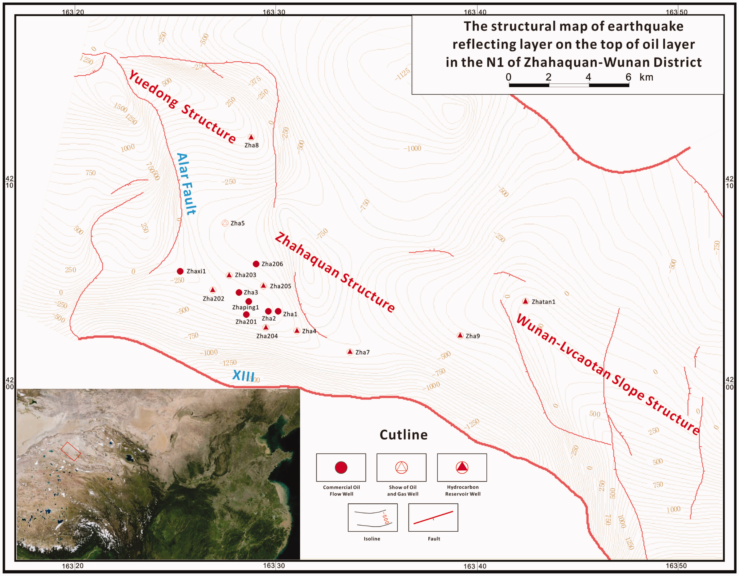
By comparison it is found that the upper Ganchaigou formation (N1) in the Zhahaquan Area of the Qaidam Basin has great potential to develop tight oil reservoirs. This area appears to be geologically similar with the Bakken tight oil area of North Dakota in America (Jing et al., 2012; Lin et al., 2011; Nordeng., 2009; Petzet, 2006; Schmoker and Hester, 1983).
Sedimentary characteristics of stratum
Simple list of structure stratum in the Zhahaquan Area.
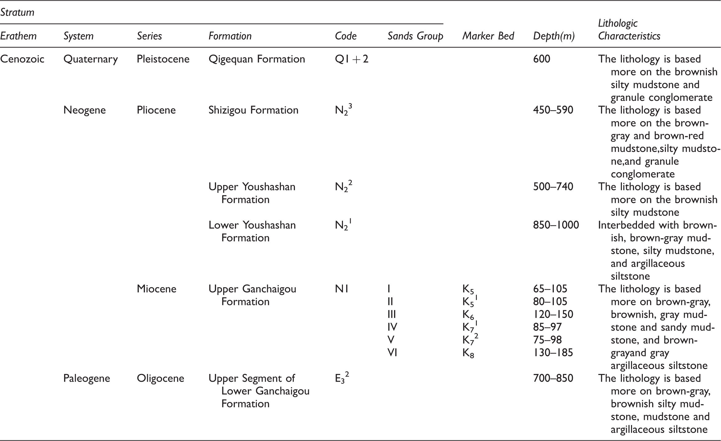
Qigequan formation (Q1+2): the lithology is based more on brownish silty mudstone and granule conglomerate sandwiched with brown-yellow argillaceous siltstone and a small amount of brown-yellow pebbly fine sandstone and brown-yellow pebbly siltstone. The Qigequan formation is conformably contacted with the underlying strata.
Shizigou formation (N23): the lithology is based more on brown-gray and brown-red mudstone, silty mudstone, and granule conglomerate, sandwiched with brownish and brown-gray argillaceous siltstone and a small amount of gray-white fine sandstone. The Shizigou formation is conformably contacted with the underlying strata.
Upper Youshashan formation (N22): the lithology is based more on brownish silty mudstone sandwiched with brown-yellow argillaceous siltstone, granule conglomerate and a small amount of brown-gray pebbly sandstone. The Upper Youshashan formation is conformably contacted with the underlying strata.
Lower Youshashan formation (N21): interbedded with brownish, brown-gray mudstone, silty mudstone, and argillaceous siltstone; sandwiched with a small amount of gray-white fine sandstone, granule conglomerate, and gray calcareous clay; and conformably contacted with the underlying strata.
Upper Ganchaigou formation (N1): the lithology is based more on brown-gray, brownish, gray mudstone and sandy mudstone, and brown-gray and gray argillaceous siltstone, sandwiched with brown-gray, gray-white fine sandstone, brownish siltstone and a small amount of gray-white calcareous clay, brown-gray coarse sandstone, brownish pebbly anisomerous sandstone and gray-white medium sandstone.
Upper segment of lower Ganchaigou formation (E32): no bottom. The lithology is based more on brown-gray, brownish silty mudstone, mudstone and argillaceous siltstone, sandwiched with gray, gray-white fine sandstone and brownish siltstone, fine sandstone and pebbly anisomerous sandstone.
Formation conditions for tight oil
Source rock
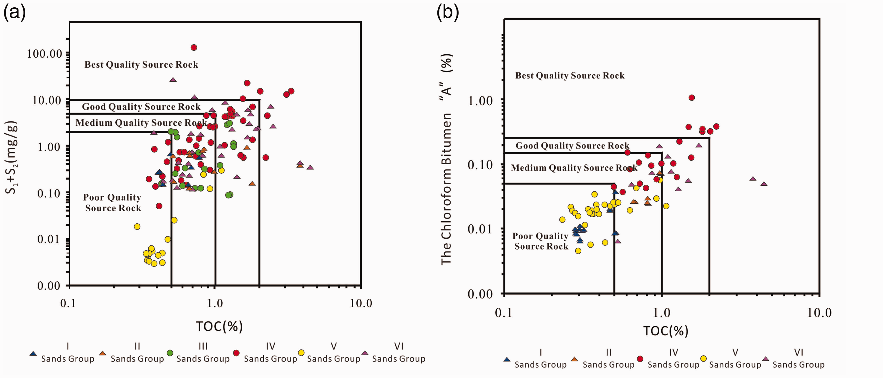
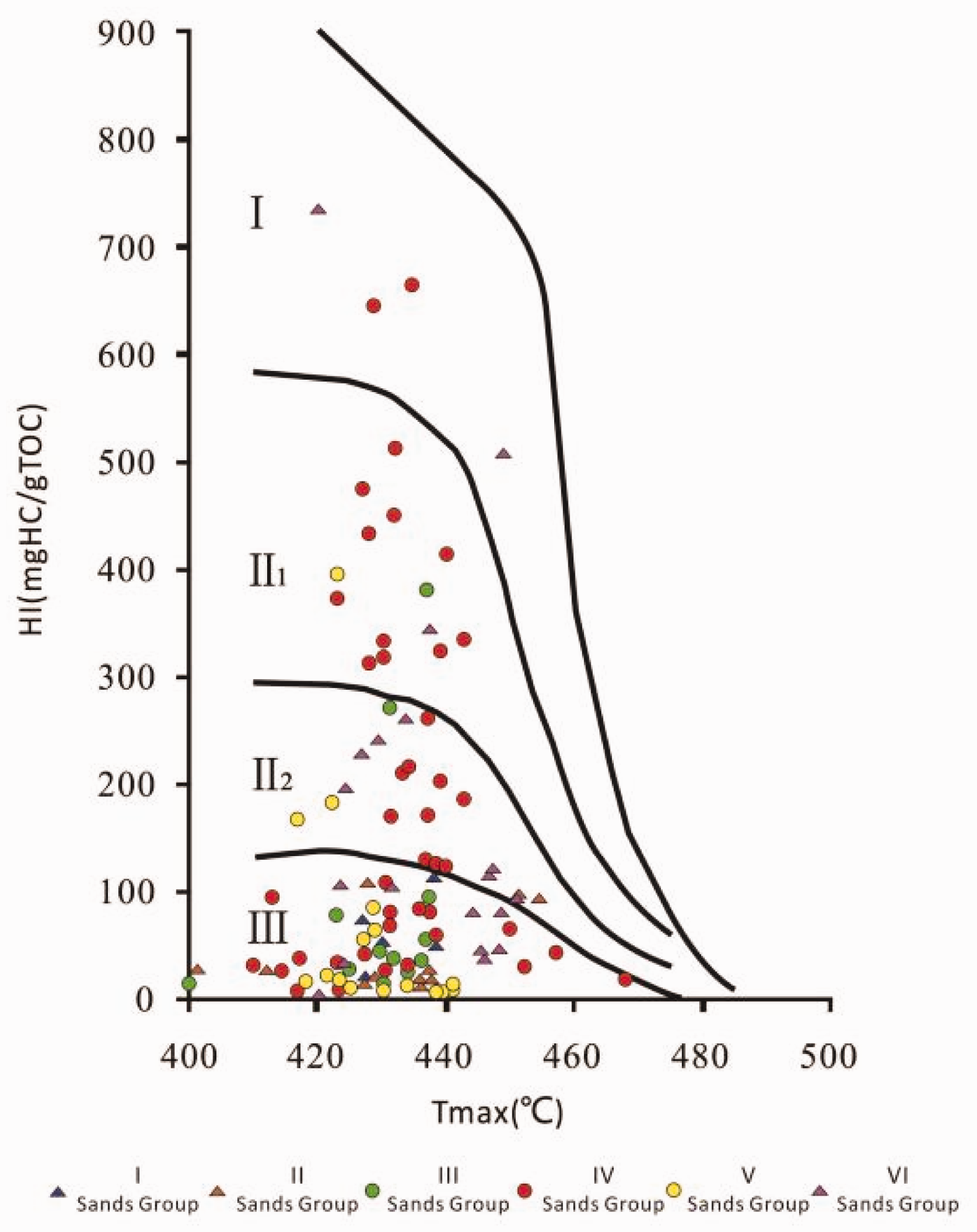
The geochemical experiment indicators of the source rocks in the upper Ganchaigou formation (N1) of Zhahaquan Area mainly include four quantitative parameters as follows: the vitrinite reflectance (Ro), the organic carbon (TOC, %), the chloroform bitumen “A” (EOM, %), and the potential hydrocarbon generation amount of rock pyrolysis (S1 + S2, mg/g).
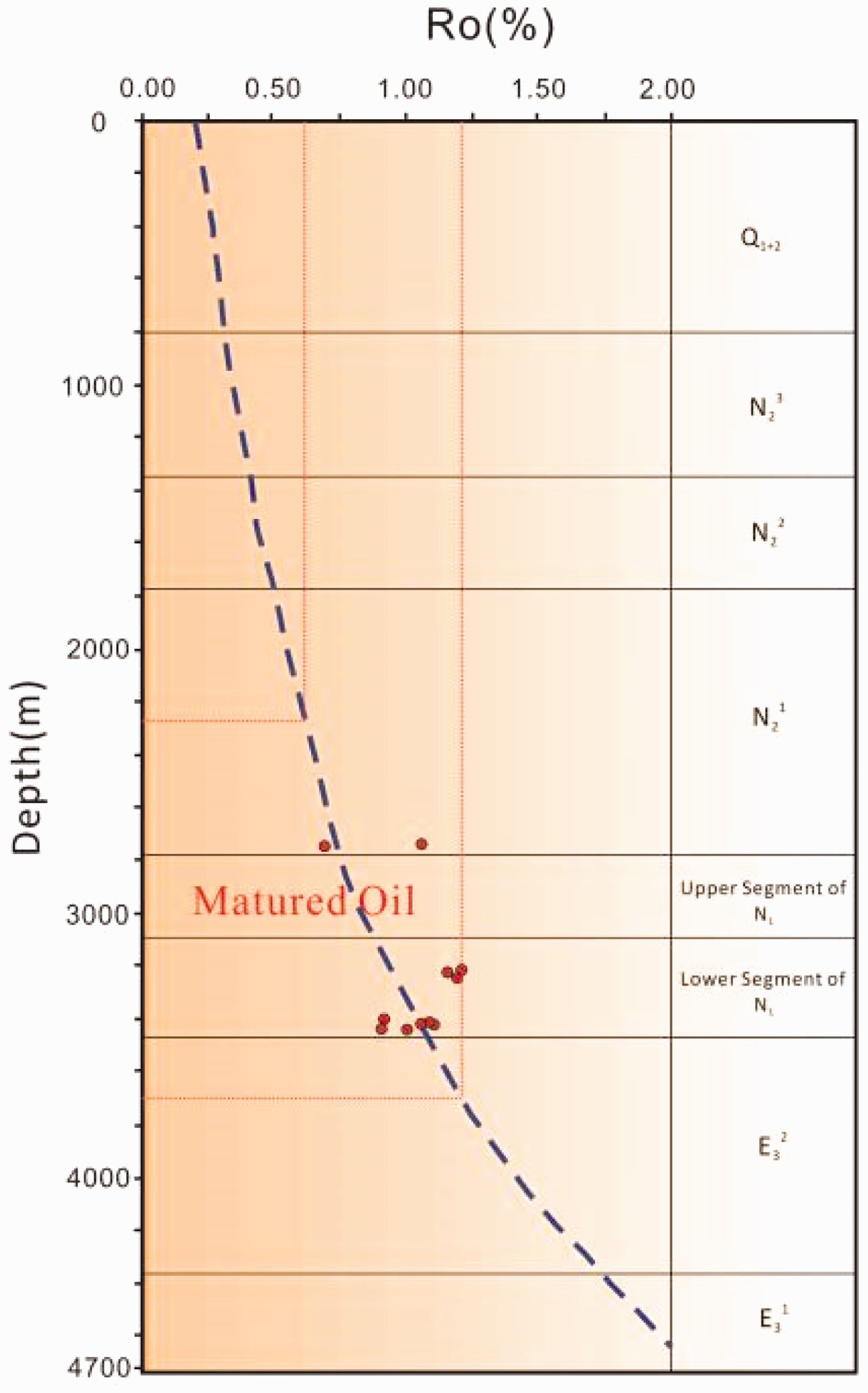
Based on the actual data obtained from the drilling core and the drilling rock debris in the research area, the main type of source rocks in the upper Ganchaigou formation (N1) of Zhahaquan Area is the dark mudstone. Using residual organic carbon to evaluate the abundances of source rocks, the following results can be observed: the source rocks in the IV and VI sand groups have the highest abundances of organic matter, in which the average content of the organic carbon (TOC, %) in the IV sand group is 0.91% and the average content of the chloroform bitumen “A” is 0.179%; the average content of TOC in the VI sand group is 0.82% and the average content of chloroform bitumen “A” is 0.036%; followed by the II sand group in which the average content of TOC is 0.79% and the average content of chloroform bitumen “A” is 0.042%; and the I and V sand groups have the lowest abundances of organic matter (Figures 2(a) and (b) and 3(b)). The experimental results of the potential hydrocarbon generation amount of rock pyrolysis also show that: the IV and VI sand groups in the upper Ganchaigou formation (N1) have the highest abundances of organic matters (Figure 3(a)). The main type of organic matter in the research area is the II–III kerogen (Figure 4). In accordance with China’s evaluation standards on the abundance of organic matters of the terrestrial source rocks (Huang et al., 1984), as well as the comprehensive evaluation of the geochemical indicators of the organic carbon (TOC), the chloroform bitumen “A” and the potential hydrocarbon generation amount of rock pyrolysis (S1 + S2) shows that most of the source rocks in the IV and VI sands group have good quality, the quality of the source rocks in the II and III sand groups have average quality, while the source rocks in the I and V sand groups have poor quality. The research area begins to enter a mature stage (thermocatalytic oil and gas generating stage) when Ro is approximately equal to 0.6% and the limited depth of the oil generating door is about 2300 m. In the mature stage, large amounts of hydrocarbon are generated in the oil generating window with Ro between 0.6% and 1.2%. The upper Ganchaigou formation (N1) is in the matured oil generating stage (Sonnenberg and Pramudito, 2009) (Figure 5).
Statistical value of TOC and chloroform bitumen “A” of each sands group in the N1 of Zhahaquan Area. Evaluation indicators of hydrocarbon source rock of each sands group in the N1 of Zhahaquan Area. Statistics for the types of organic matters of each sand groups in the N1 of Zhahaquan Area. Mode pattern for the evolution of organic matters in the N1 of Zhahaquan Area.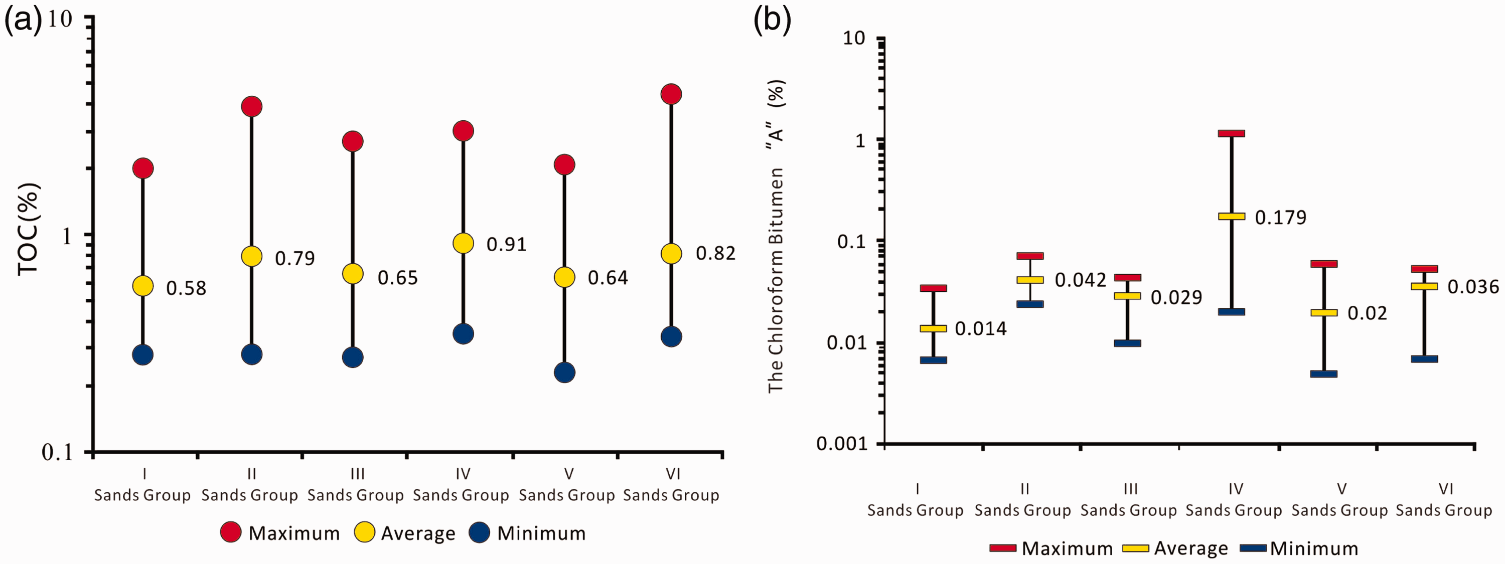
Reservoir stratum
Characteristics of lithology, physical property, and oil bearing
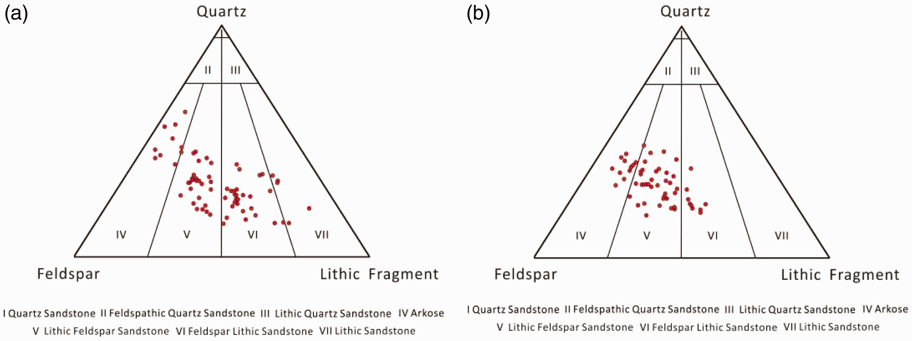
On the basis of the observation of drilling core and the analysis of test data of particle size, the coarse sandstone (Figure 6(a)), the medium sandstone (Figure 6(b)), the fine sandstone (Figure 6(c)), and the siltstone (Figure 6(d)) can be seen in the rock core of the Zhahaquan Area, where the deposition of fine particle occupies a dominant position; it gives priority to the silty-fine sand and the siltstone. The physical property of the sandstone is good; the oil bearing level is also very high, generally oil immersed-oil stains. In most cases, the siltstone is interbedded with the mudstone (Figure 6(e)) and has very strong heterogeneity. The oil bearing level is oil stains. The lithology of the reservoir stratum of tight oil on the upper segment (I, II, and III sand groups) of the upper Ganchaigou formation (N1) is mainly arkose, lithic feldspar sandstone, and feldspar lithic sandstone (Figure 7(a)); and the lithology of the reservoir stratum of tight oil on the lower segment (IV, V, and VI) of N1 is arkose, lithic feldspar sandstone, feldspar lithic sandstone, and lithic sandstone (Figure 7(b)).
Pictures of rock cores in the N1 of Zhahaquan Area. (a) zha3 3005.94 m Oil immersed coarse sandstone (b) zha2 3035.52 m Medium sandstone with oil spot. (c) zha2 3302.87 m Oil immersed fine sandstone. (d) zha4 3306.35 m Siltstone. (e) zhaping1 3419.50 m Interbedded siltstone and mudstone, seen the wavy bedding and the lenticular bedding. Triangular composition diagram for lithological statistics of reservoir stratum in the N1 of Zhahaquan Area.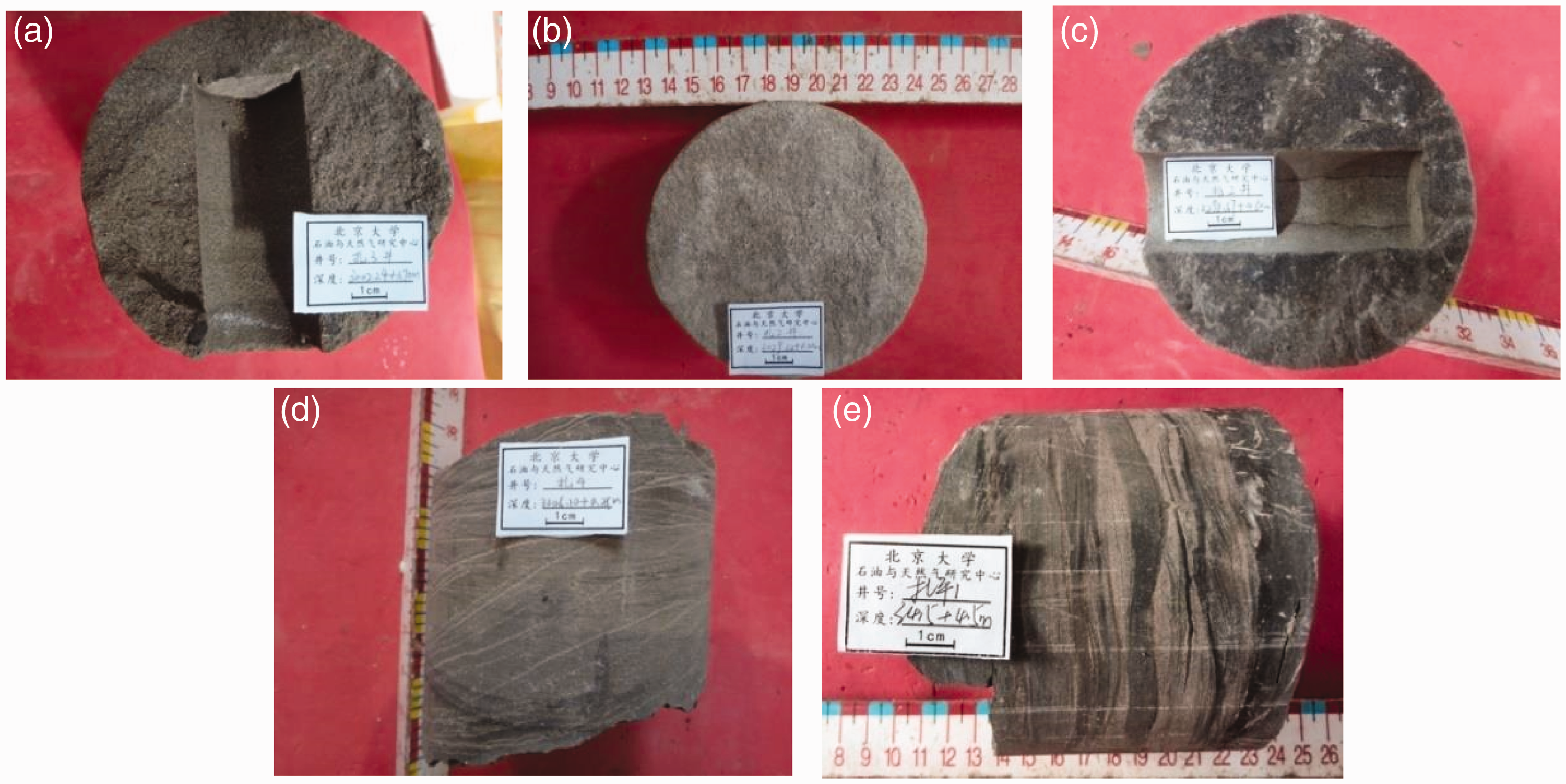
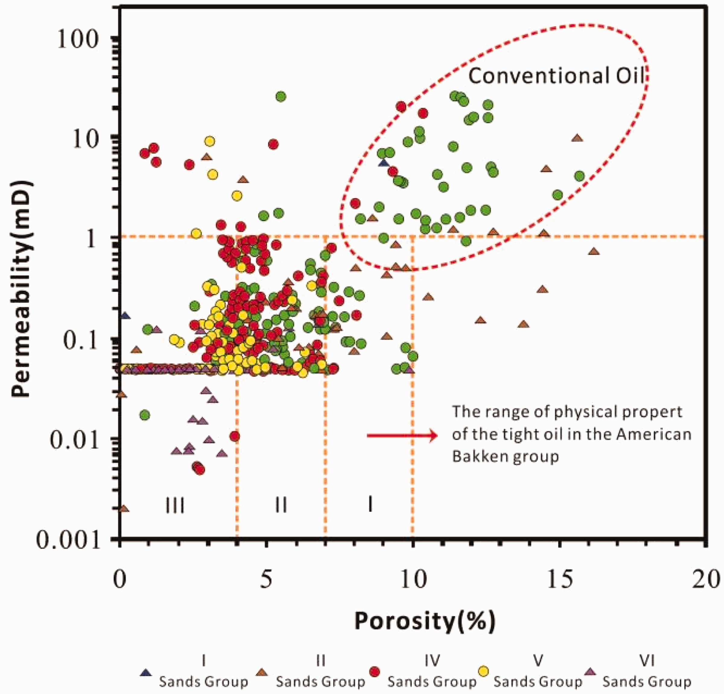
It can be seen from the frequency distribution histogram based on the permeability and porosity of rock core samples in the research area that: the porosity of the reservoir stratum on the upper segment (II and III sand groups) of N1 is mainly distributed in the range of 4–6% and more than 9%, and the permeability of the reservoir stratum is mainly distributed in the range of 0.1–1 mD (Figure 8(a) and (b)). However, the porosity of the reservoir stratum on the lower segment (IV, V, and VI sand groups) of N1 is mainly distributed in the range of 3–5%, and the permeability of it is mainly distributed in the range of 0–0.05 mD (Figure 8(c) to 8(e) ). Based on the physical property parameters of 18 drilling cores and the statistical method of oil bearing occurrence, the lower limit of porosity for the physical property of tight oil of Zhahaquan Area is determined to be 3% and the lower limit of air permeability is 0.008 mD (Figure 9). The tight reservoir stratum that has porosity less than 4% is nanopore-based and still has certain resources (Daniel et al., 2009; Loucks et al., 2009; Miller et al., 2008; Schmoker and Hester, 1983; Webster, 1984; Zeng and Jiang, 2009). Among the rock core samples, the lithology with oil spots and oil stains is in the argillaceous siltstone, the siltstone, and the silty-fine sandstone. The oil immersed lithology is in the fine sandstone, the medium, and the coarse sandstone. The coarser the particle size is the higher the oil bearing level. In combination with the features of the reservoir stratum of tight oil in the Zhahaquan Area, it can be divided into three categories: type-I reservoir stratum with porosity of 7–10% and air permeability of 0.05–1 mD, type-II reservoir stratum with porosity of 4–7% and air permeability of 0.05–1 mD, and type-III reservoir stratum with porosity of 0–4% and air permeability of 0.05–0.3 mD. The lower segment (IV, V, and VI sand groups) of N1 is mainly the tight reservoir stratum and the upper segment (II and III sand groups) of it is mainly the conventional reservoir stratum and partially the tight reservoir stratum, which is mostly type-I and type-II reservoir stratum. The porosity of IV sand groups is mostly in the range of 2–9%, close to the range of the physical properties of the tight oil in the American Bakken group. The physical properties of V and VI sand groups are poorer than that of IV sand groups and are mainly the type III reservoir stratum (Figure 9).
Frequency distribution histogram for physical properties of the reservoir stratum in the N1 of Zhahaquan Area. Classified evaluation map of reservoir stratum of each sands group in the N1 of Zhahaquan Area.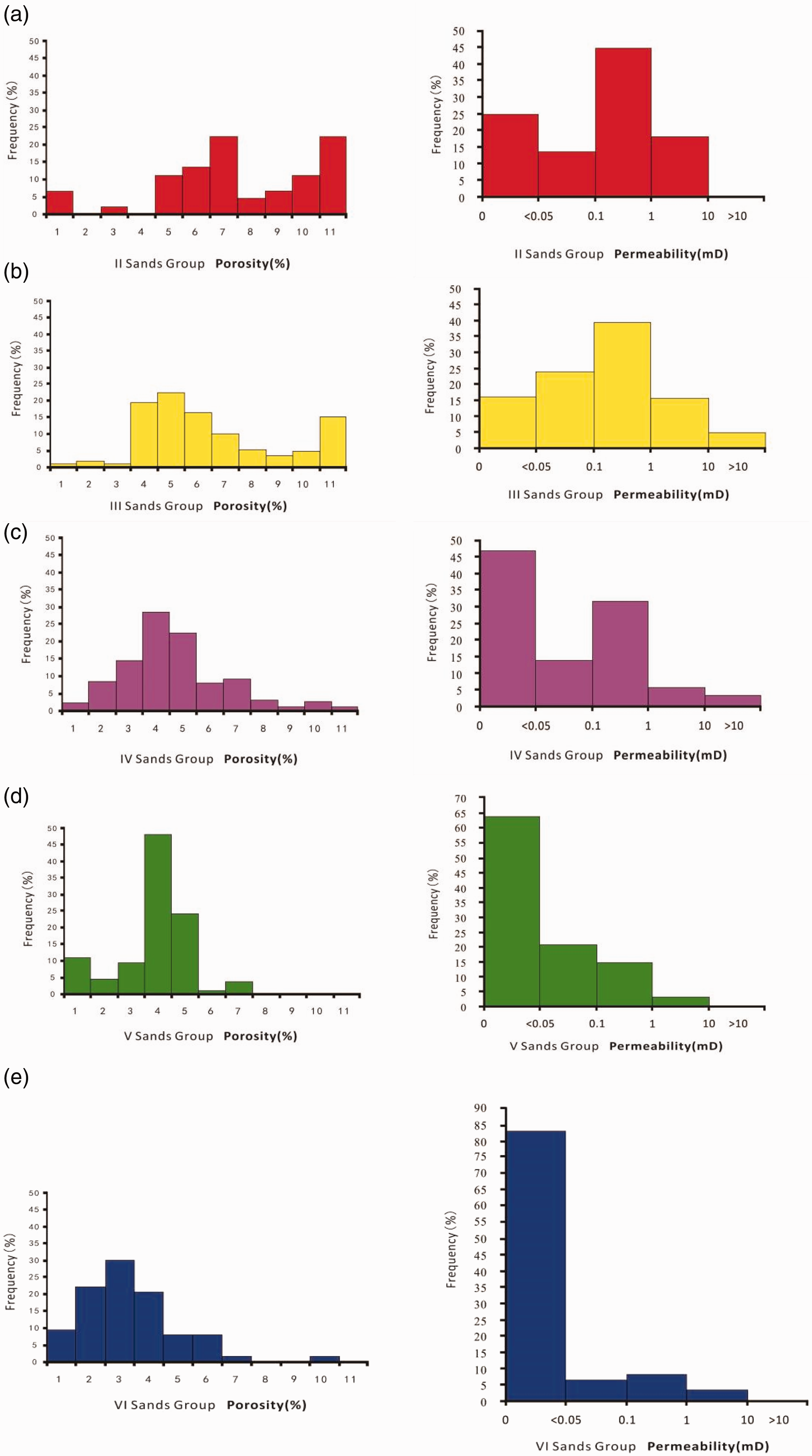
Types and characteristics of reservoir space
The ranges of the apertures of the reservoir stratum of tight oil are classified as the millimeter, the micrometer and the nanometer level storage spaces, in which the pores of the millimeter and the micrometer level storage spaces are mainly comprised of residual intergranular pores and the corrosion holes. The nanometer level storage space mainly consists of granular inner holes, the intracrystalline pores and the microfractures. The nanometer aperture ranges from 300 to 900 nm (Zou et al., 2011) and the nanometer pore plays an important role in the reservoir space of tight oil (Pang et al., 2012).
According to the scanning electron microscope and the rock slice identification, the types of the reservoir space on the reservoir stratum of tight oil in the research area are mainly the primary intergranular pores and the residual intergranular pores, secondly the corrosion holes and the intracrystalline pores, and finally the microfractures (the elongated pore attached to the particle, the construction joint, and the dissolution fractures). The pore size is between 0.3 and 10 µm (Figure 10). The pore structure mainly consists of the small pore with fine throat. The radius of the pore throat is less than 0.1 µm. Fluids have difficulties flowing due to low permeability and low porosity. The physical properties of the tight reservoir stratum are improved by various secondary corrosion holes and microfractures developed in the space of reservoir stratum.
Scanning electron microscope and rock slice identification in the N1 of Zhahaquan Area.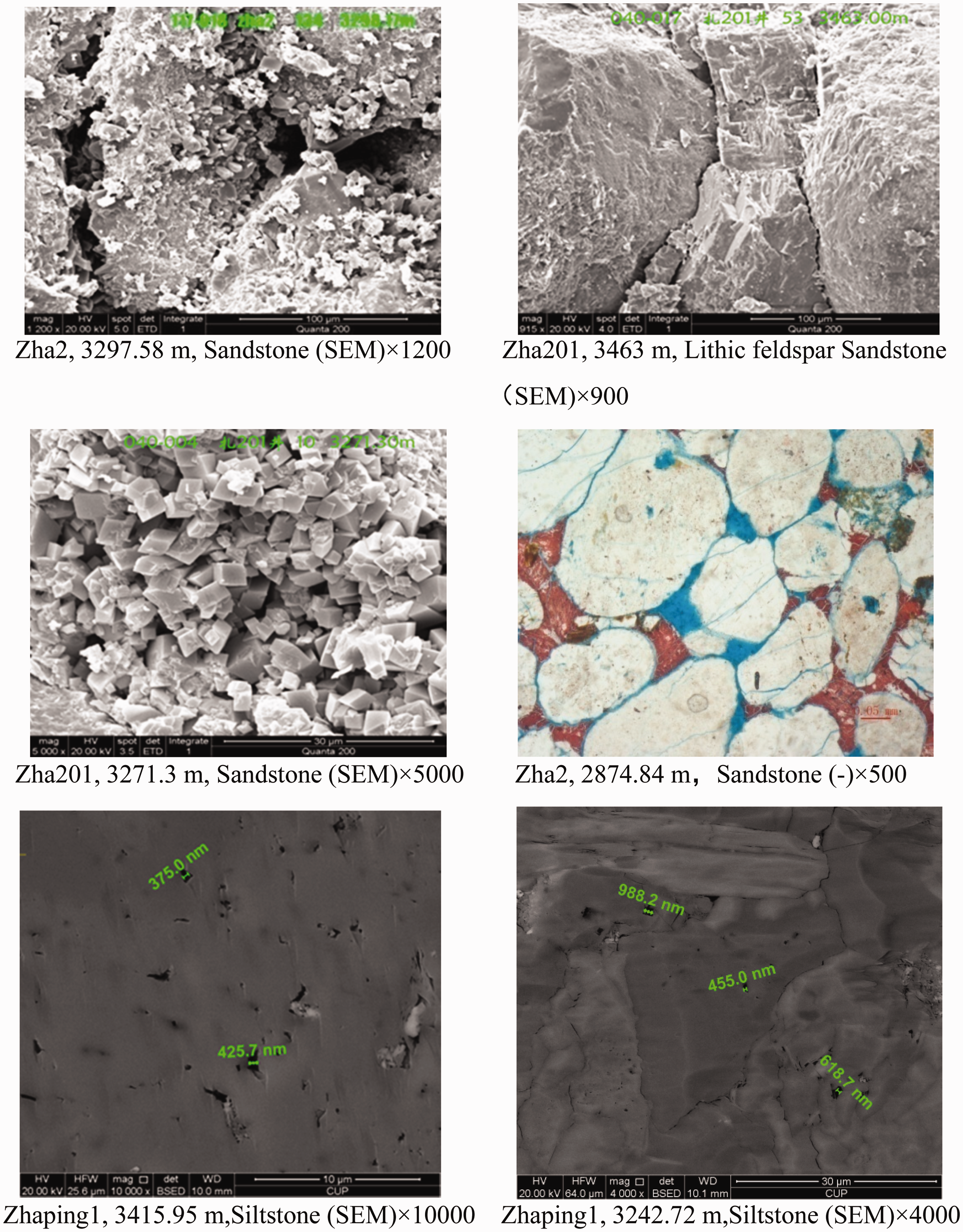
Distribution characteristics of sand body of reservoir stratum
Based on the analysis of the facies markers such as the colors, the structures, the formation, the particle size and the vertical sequence, the overall sedimentary facies of the tight oil developed in the Zhahaquan Area is equal to the overall lacustrine facies. Various types of lithofacies are summarized in Figure 11. It is considered that the tight oil in the Zhahaquan Area is mainly developed in the beach and dam sedimentary system of shore-shallow lake-semi-deep lake and various sand bodies of gravity flow facies belts. The distribution of sand bodies in the area has characteristics as follows: multi-layer; the sand is thin; the sand is interbedded with the mud; the overall particle size is small; and the thickness of the sand body in the N1 is not greater than 1 m. In accordance with the description of the drilling core, the parallel bedding, the swash cross bedding, the wave corrugated cross bedding, the horizontal bedding, the graded bedding, the massive bedding, and the deformation structure are developed. The parallel bedding is mainly developed in the medium-coarse sandstone, which indicates a strong hydrodynamic condition. The swach cross bedding is mainly developed in the shoreland, beach, and dam with functions of bi-directional flow. The wave corrugated cross bedding is mainly developed in the shallow of the shore-shallow lake of the siltstone and the argillaceous siltstone. The horizontal bedding is mainly developed in the dark gray mudstone and the grayish green-caesious mudstone, which indicates weak hydrodynamic conditions. The graded bedding has developed the landmark bedding of the event sediment of normal graded bed sequence, reverse graded bed sequence, and gravity flow sediment. The deformation structure has developed the speedily deposited gravity flow sedimentary system of the load cast and the water escape structure due to the density difference. It is also found that the rock core is in the boulder clay whose colors are mainly grayish green and caesious, sometimes red-brown due to the sedimentary characteristics of the storm transformation. The formation is mostly due to the erosion of storm flow and the transformation of refluxing.
Mode pattern of sedimentary facies on the plane of IV sand group in the N1 of Zhahaquan Area.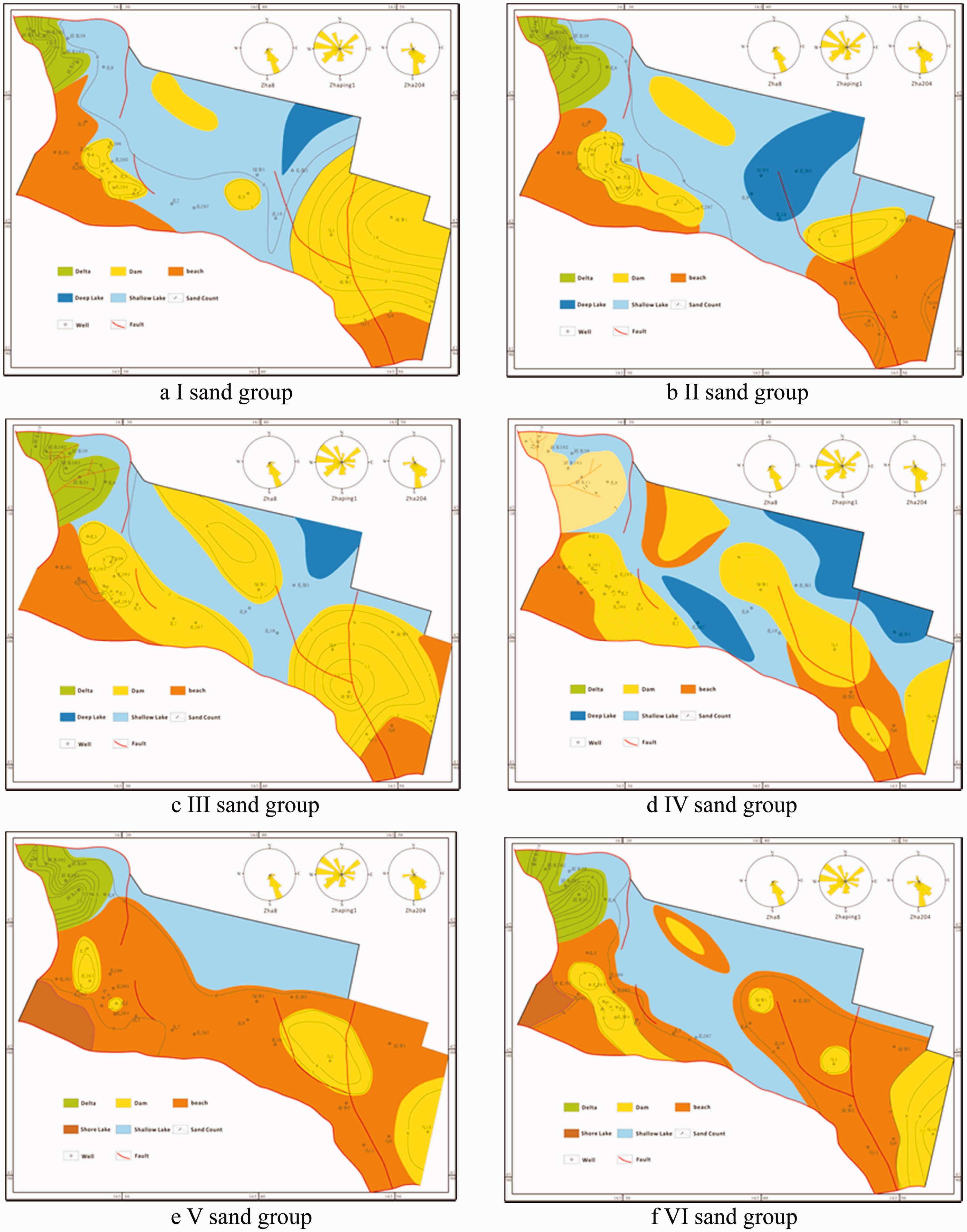
Source storage configuration
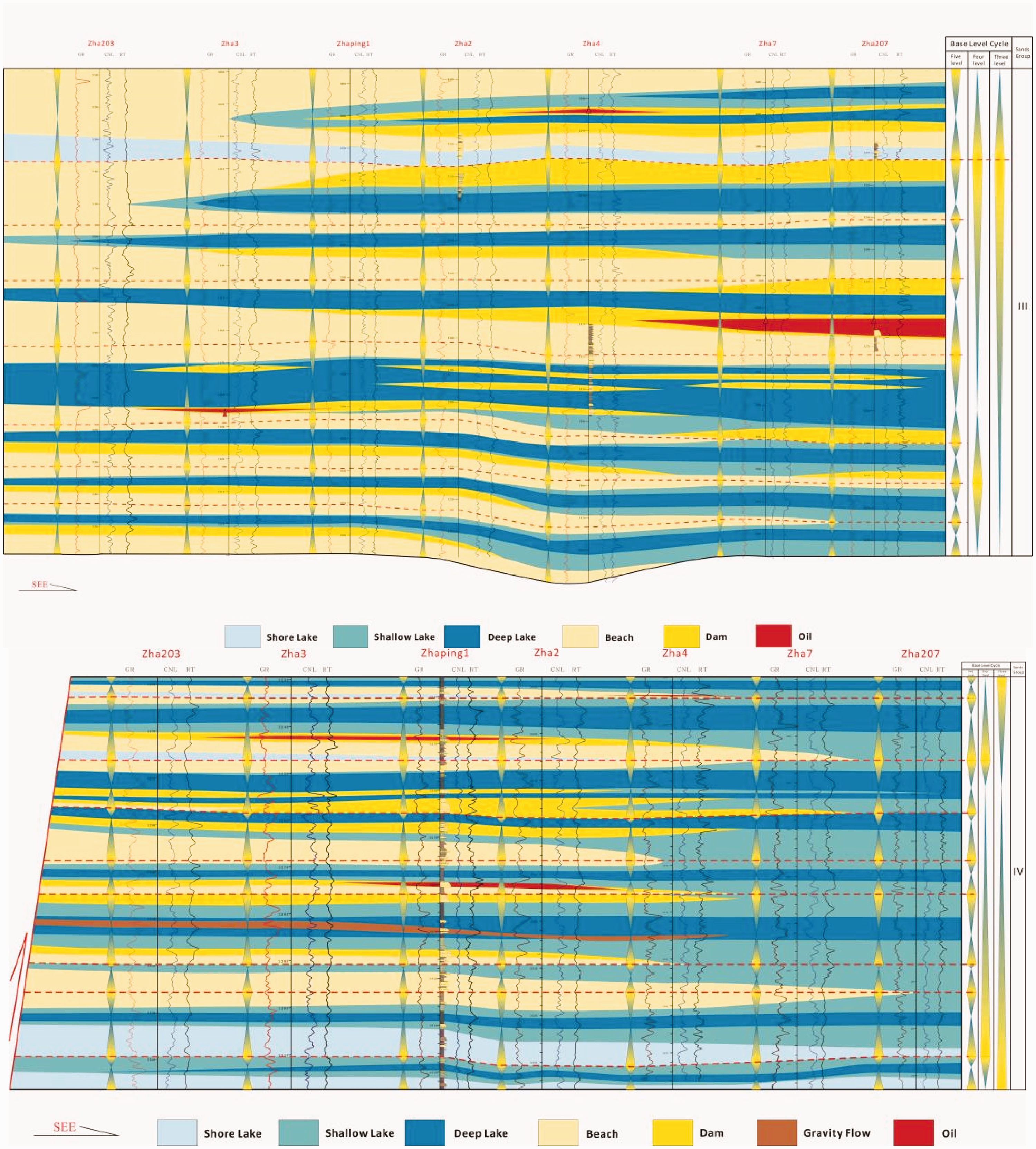
The oil reservoirs of the lower permeability and tight clastic rock in the Yanchang formation of the Ordos Basin as well as in the Lianggaoshan formation and Shaximiao formation of Jurassis system of Sichuan Basin were respectively, studied by Guo et al. (2012) and Pang et al. (2012). The study results showed that tight oil is mainly distributed in the area where the reservoir stratum of clastic rocks is close to the stratum of sapropel-type high-quality hydrocarbon source rocks with proper maturity, and the area where the tight reservoir stratum is tightly close to the stratum of source rock (Guo et al., 2012). One of the key conditions for forming a tight oil formation in the Zhahaquan Area is the superior source storage configuration. The reservoir stratum of tight oil in the Zhahaquan Area is mainly distributed on sandy beaches, in dams of the lacustrine facies belt and the gravity flow sand of the delta front. The sand part of the reservoir stratum is mainly comprised of the dam’s sand followed by the beach’s sand. Overall, dam sand is one of the best reservoir bodies in various reservoir stratums (Figure 12). The “lithology lenticle” with good physical properties can obtain oil that can be used to make gas. The reservoir body of bar sand is directly in contact with the source rocks of deep lacustrine facies, arranged in the source rocks of lacustrine facies like a finger or interbedded with the source rocks. The productive reservoir stratum is mostly located on the beach and in the dam’s sand under the dark mudstone, superimposed with each other (Figure 13). The up and down of the oscillation on the medium-short term base level is the main formation mechanism for the superimposed bar sand bodies and transgressive mudstone layers.
Statistics for physical property and oil content of each sand body in the N1 of Zhahaquan Area. Mode pattern of source reservoir configuration on the III sand group and IV sand group in the N1 of Zhahaquan Area.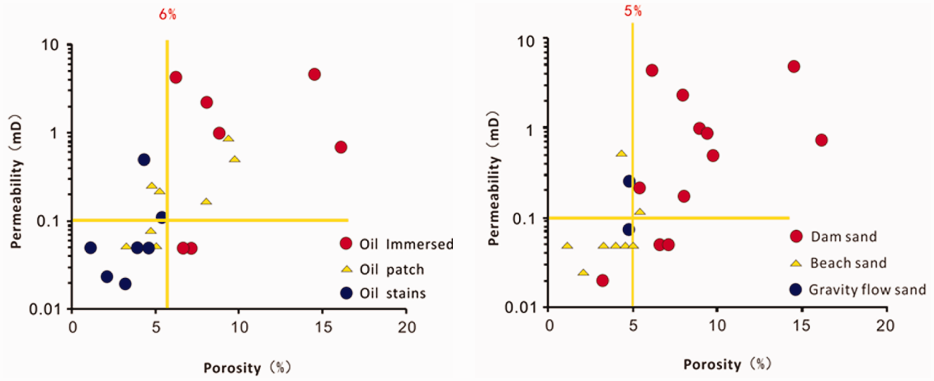
Formation pressure
It is measured that the formation pressure coefficient in the development zone of tight oil under the III sand group of Zhahaquan Area is 1.3–1.5, which is abnormally high (Figure 14). The main reasons for the abnormally high pressure is that the tight oil is located in the sunken hydrocarbon that generates central position and is deeply buried; meanwhile, the unevenly compacted, tectonic, hydrothermal, and hydrocarbon generating functions enable the stratum to form high pressure (Fu and Meng, 2003; Fu and Wang, 2007; Xiang et al., 2006). Due to the poor heterogeneity and physical properties of the reservoir stratum of tight oil, the oil gas can be filled, removed, and reserved successively under certain high pressure. Therefore, the abnormal high pressure is the driving force for the oil reservoir in the tight reservoir stratum of Zhahaquan Area.
Statistical chart for abnormal high pressure in the N1 of Zhahaquan Area.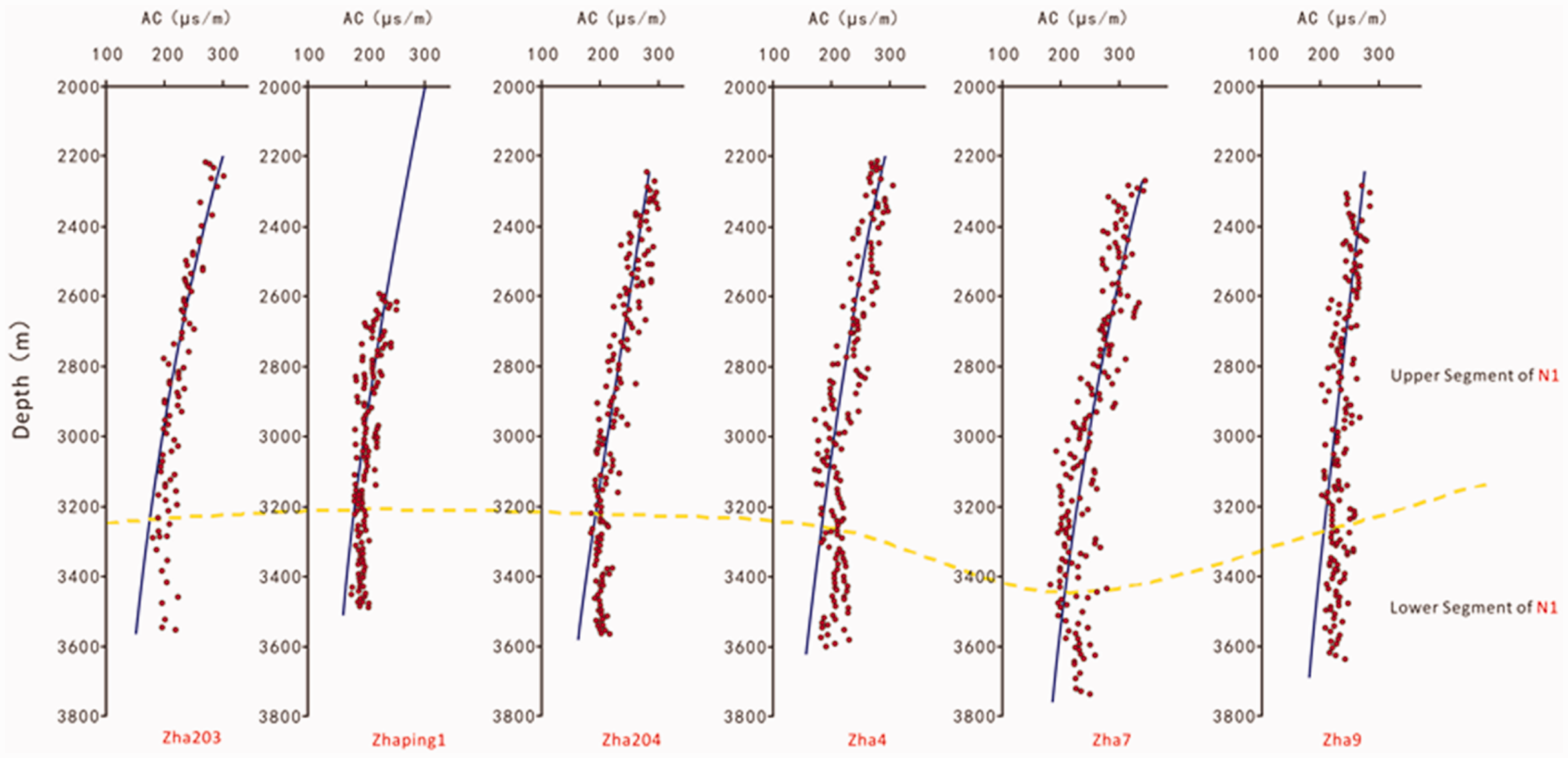
Distribution regularities and main controlling factors of tight oil
Distribution regularities of tight oil
The work area is characterized by generally developed tight oil, a larger oil bearing area, connectivity, and no obvious boundaries for oil reservoirs. Based on the distribution regularities of the current oil producing reservoir stratum, it is found that the oil layer is mainly distributed in the III, IV, and VI sand groups and good quality hydrocarbon source rock is mainly distributed in the IV, VI, and II sand groups. This indicates that the tight oil layer is directly located in the hydrocarbon source rock, or tightly close to the hydrocarbon source rock of good quality reserved in the source and next to the source (Figure 15). Until now, we have discovered that the oil layers which have been discovered are mainly developed in the better hydrocarbon source rock and close to the hydrocarbon source rock. The bar sand is located near the oil sources.
Distribution regularities of tight oil in the N1 of Zhahaquan Area.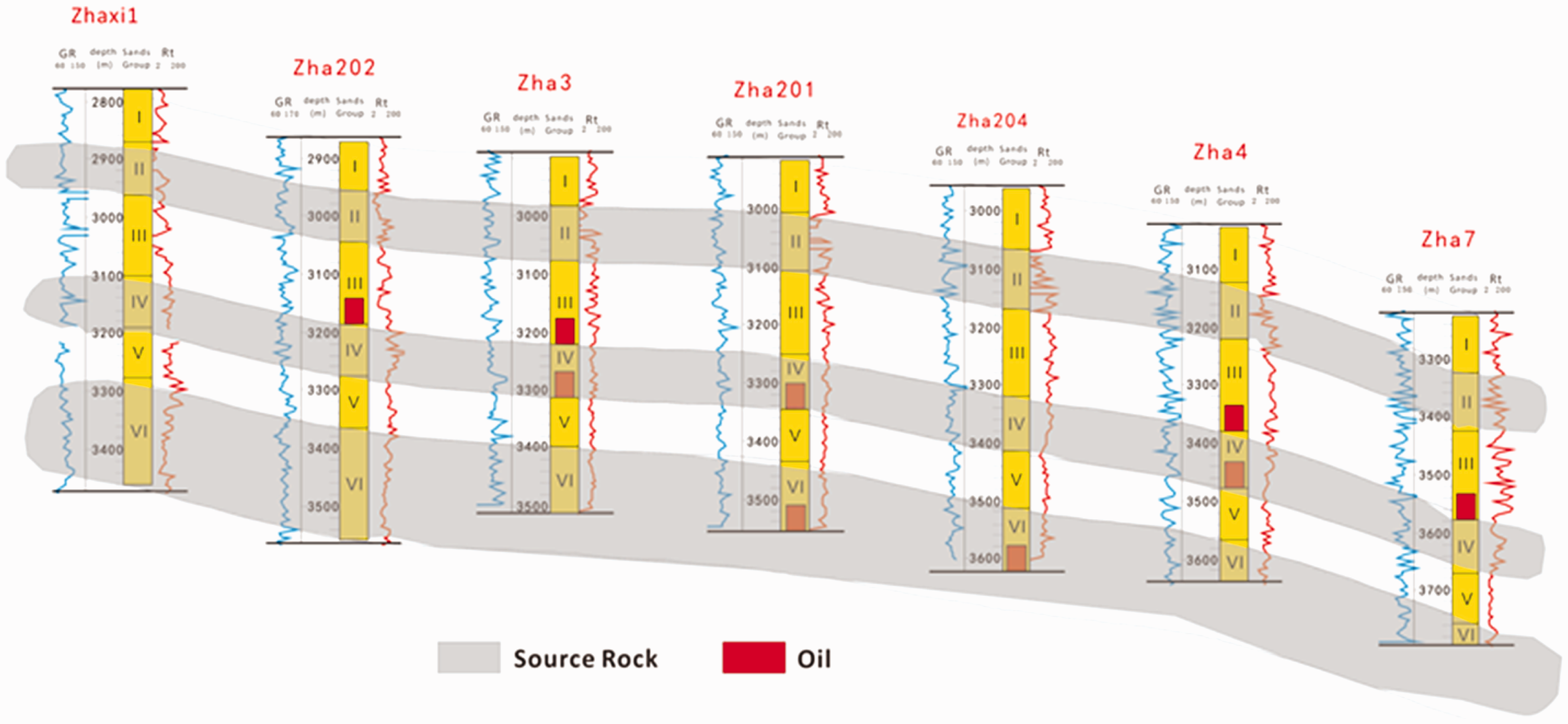
Main controlling factors
Lithology and physical properties of reservoir
The lithology of the reservoir stratum in the work area has a significant control effect on the distribution of the tight oil. The oil is found in the siltstone, the fine sandstone, and the medium sandstone of the tight oil region. The argillaceous siltstone with more argillaceous components, the calcareous siltstone with more calcium, and the pure siltstone have bad oil contents; while the oil immersed lithology is mainly found in the fine sandstone, the medium sandstone, and a small number of coarse sandstone. The distribution of tight oil is controlled by the physical properties of reservoir stratum. The bar sand has good porosity and permeability. The better the physical property of the reservoir stratum, the better the oil content. There is a desert, too. Statistics shows that the reservoir stratum with 7–12% of tight oil has the best oil content, secondly the reservoir stratum with 4–7% of porosity, finally the reservoir stratum with porosity less than 4%.
Sedimentary facies and reservoir sand body
The combination features of heavy minerals shows that the sand body sediment in the Zhahaquan Area is mainly the western material source. Due to the control of the western material source, the sedimentary facies of N1 in the Zhahaquan Area are mainly the beach bar sediment of shore-shallow lake-semi-deep lake of the lacustrine facies and the gravity flow deposit (partly formed by the storm disturbance). In combination of the colors, the lithology, the construction, and the structural features of the rock cores, a variety of lithofacies were discovered in the Zhahaquan Area. Meanwhile, the mode pattern of sedimentary facies is built in accordance with the vertically upward change features of the sedimentary facies and the Walter’s law of facies (Figure 16). The reservoir stratum in the research area is characterized by wide distribution, far extension, staggered sand bodies, good continuity, stable distribution, and appropriate sand ground ratio, becoming a major distribution area for tight oil. As for the IV sand group, the sedimentary tectonics formed by large amount of tractive current and the sedimentary tectonics formed by a small amount of gravity current are found in the sedimentary tectonics of rock cores. The wave corrugated cross bedding is a typically wave caused bedding; the graded bedding is mainly formed by the gravity current; and the flaser bedding and the wavy bedding represents the hydrodynamic changes or the changes in sand or mud supply. The horizontal distribution and the spatial distribution of tight oil are controlled by the sedimentary facies belt and the sand body in the Zhahaquan Area, providing a large area of tight oil with favorable reservoir space.
Mode pattern of horizontally upward sedimentary facies in the N1 of Zhahaquan Area.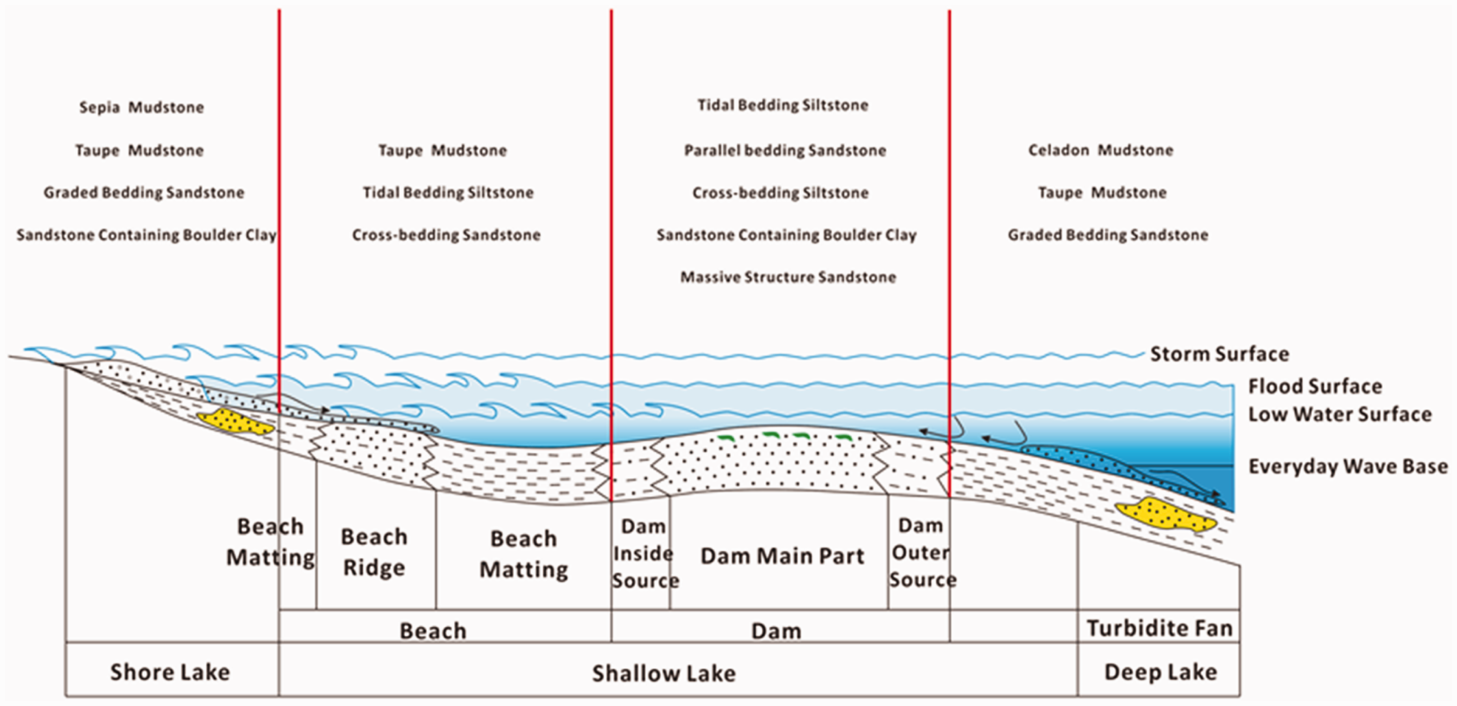
Evaluation on the potential of tight oil
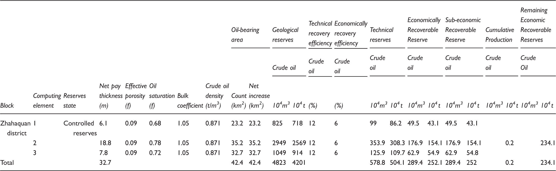
Statistical table for quantity of tight oil resource of each oil layer in the N1 of Zhahaquan Area.
Conclusions
The Zhahaquan Area of Qaidam Basin has hydrocarbon source rocks conditions, reservoir stratum conditions, source reservoir configuration conditions, and abnormal high pressure formation conditions. The upper Ganchaigou formation (N1) in this area has developed three sets of high-quality hydrocarbon source rocks, providing a good material base for hydrocarbon generation. The average value of the organic carbon (TOC, %) is 0.88% and the average value of the chloroform bitumen “A” is 0.11%. The main type of the organic matter is the II–III type kerogen. The vitrinite reflectance Ro of the research area is approximately equal to 0.6%. In a mature stage, the depth of oil generative threshold is about 2300 m and a large amount of hydrocarbon is generated. The upper Ganchaigou formation (N1) is in the mature stage of oil generation. There are many types of sand bodies in the reservoir stratum, mainly including the dam sand, the beach sand, and the gravity flow sand body. The dam sand has the best physical properties and oil content. The upper segment of upper Ganchaigou formation (N1) consists partly of conventional reservoir stratum and partly of tight reservoir stratum, the lower segment of it is mainly developed for the tight oil reservoir. The oil bearing series are mainly distributed in the III, IV, and VI sand groups, in the inside and close to the source. The types of the reservoir spaces of the reservoir stratum of tight oil are mainly the native intergranular pores and the residual intergranular pores, secondly the corrosion holes and the intracrystalline pores, and finally a small amount of microfractures. All kinds of sand bodies are characterized by wide planar distribution and good continuity, which provides the tight oil with a favorable gathering space. The condition for source reservoir configuration is good. The sand body of reservoir stratum is directly in contact with the hydrocarbon source rock, or located among the hydrocarbon source rocks of the deep lake-semi-deep lake facies, or interbedded with the hydrocarbon source rocks, which helps the oil gas to fill in the closely located sand body of reservoir stratum. The reservoir stratum of tight oil under the III sand group in the work area has an abnormally high pressure coefficient of 1.3–1.5; thus creating power for reserving the tight oil. The tight oil in the plane is mainly distributed in the sunken central position and the peripheral sunken slope. In accordance with the volume method, the quantity of geological resources are about 3.2 × 10⁸ t, which means the area has high potential for resource development.
Footnotes
Declaration of conflicting interests
The author(s) declared no potential conflicts of interest with respect to the research, authorship, and/or publication of this article.
Funding
The paper is jointly supported by the National Science and Technology Major Special Projects (2011ZX05009-002-403 and 2011ZX05004-004-005) and the National Key Basic Research Development Planned Project (2012CB214801).