
Abstract
Understanding the coal seam gas occurrence law is the premise and foundation of gas disaster prevention and production planning. The tectonic control law and zoning division of gas occurrence in Sichuan Province have been discussed, based on the gradual tectonic control theory for gas occurrence, combined with coal mine gas-geology data and a geological survey in Sichuan Province. The obtained results indicate that the generation, migration, and preservation of gas are controlled by the formation and development, cracking, subduction collision, and intracontinental orogeny of the upper Yangtze block. The gas occurrence and distribution characteristics in Sichuan Province are significant. Gas occurrence of Late Permian coal seams is significantly higher than that of Late Triassic coal seams, as 85.7% of the outburst mines in the Sichuan Province are distributed into the Late Permian coal seams. The Late Permian coal seams in the Xuyong-Junlian superimposed fold belt and Huayingshan detachment fold belt are high gas occurrence zones. These zones had been under strong tectonic compression for several years, thereby resulting in interlayer sliding, formation of stratified tectonic coal, and high degree of coal metamorphism and high gas content, which represent the fundamental reasons why 84.3% of outburst mines in Sichuan Province are located in these two regions. According to the tectonic control law and characteristics of coal seam gas occurrence in Sichuan Province, the gas occurrence zones of coal seam in Sichuan Province were divided into three high gas and outburst zones, three high gas zones and one low gas zone; in addition, their tectonic control characteristics and gas occurrence characteristics were analysed.
Keywords
Introduction
The coal seams in China mainly formed in seven geological eras, namely Carboniferous, Permian, Triassic, Jurassic, Cretaceous, Paleogene, and Neogene periods, which were distributed in the three small cratons of Zhongchao, Yangtze, and Tarim, several micro continental massifs and orogenic belts. The coal seams underwent tectonic movements in multiple periods, such as Indosinian, Yanshanian, and Himalayan tectonic movements (Ren et al., 1980; Yang and Han, 1979). Tectonic structures and their evolution are controlled by three dynamic systems in sequence: the ancient Asian Ocean, Tethys Paleo-Pacific Ocean, and Indian Ocean-Pacific Ocean (Ren et al., 1999, 2016). The complex tectonic evolution background leads to the severely complicated tectonic controlling characteristics for coal seam gas occurrence in China, which is also an important reason for the severe gas disaster in China (Zhang and Wu, 2014).
Sichuan Province is rich in coal resources, with a total verified coal reserve of 14.2871 billion tons, ranking 13th in China (Xu et al., 2015). More than 70% of the coal resources are coal seams with high gas or outburst. In total, 1081 coal and gas outburst (gas outburst for short) accidents have occurred in the Sichuan Province, with a maximum outburst intensity and minimum initial outburst depth of 3100 t and 103 m, respectively. With the increase in the coal mining depth and intensity, gas disaster has increasingly become the highest risk source that restricts coalmine safety production in Sichuan Province.
Since the 1843 gas outburst accident in France, several scholars have studied gas occurrence and gas outburst mechanism from the perspective of geological structure (David, 1988; Ettinger et al., 1953; Farmer and Pooley, 1967; Shepherd et al., 1981), coal fragmentation degree, and structure wrinkle coefficient of coal seam (Frodsham and Gayer, 1999), coal metamorphic degree (Farmer and Pooley, 1967), coal seam buried depth (Hargraves, 1983), and mining disturbance (Szirtes, 1964; Zhao et al., 2022; Zhu et al., 2022). Accordingly, it was pointed out that the necessary conditions for gas outburst are gas, tectonic coal, residual stress or structural stress, and the operation mode which is not conducive to gas release (Hargraves, 1983). Based on the eight geological factors affecting the original gas content of coal seams in 1963, which was presented by Zhou Shining, Chinese scholars have conducted in-depth studies on gas occurrence and gas outburst from the perspective of structural type (Han et al., 2012; Huang, 1992; Jiang et al., 2019; Zhang Z and Zhang Y, 2005; Zhang Z and Zhang Z, 1992; Wei et al., 2015), tectonic evolution (Jia et al., 2014; Song et al., 2005; Wang et al., 2016; Yan et al., 2015), structural stress field (Jia et al., 2015; Li et al., 2011; Yuan, 2004; Zhu and Xu, 1994), in-situ stress (Jia et al., 2013; Qin et al., 2021; Yan et al., 2020; Zhang et al., 2021; Zhu et al., 2018), tectonic coal (Zhang et al., 2007; Yang et al., 2021; Xiao and Du, 2021; Chen and Yang, 2021) and their comprehensive action (Jia et al., 2018; Jia et al., 2015; Yan et al., 2013; Zhang et al., 2014).
In summary, the current gas occurrence state is the comprehensive action result for gas formation, gas occurrence, and gas sealing systems, which include coalbed thickness, coal body structure, coalification degree, burial depth, permeability of surrounding rock, hydrogeology, geological structure, etc (Chen et al., 2020; Jack and Richard, 1998; Jiang et al., 2010; Kaiser and Ayers, 1994; Li et al., 2018; Pashin, 2007; Yan et al., 2020; Zhang et al., 2017). Owing to the difference in tectonic locations, degree of plate tectonics, and regional tectonic evolution background for coal seams at various coal basins in Mainland China, the sedimentary environment, stress field, and temperature field of various basins are different, thereby triggering differences in coal deformation and coal metamorphism. Therefore, different regional geological structures exhibit different control effects on gas occurrence, and it is difficult to apply research results for one region to other regions. This paper discusses the tectonic control law and zoning characteristics of gas occurrence in Sichuan Province, to guide the prevention and control of coalmine gas disaster and macro planning in Sichuan Province.
Geological setting
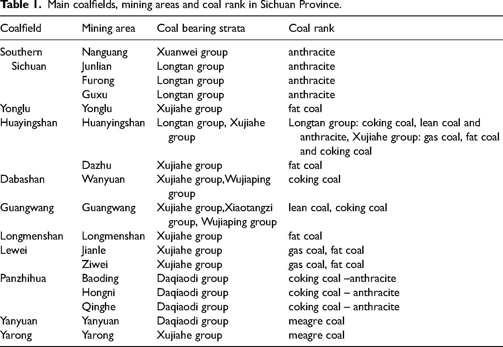
Sichuan Province is located at the junction of the paleo Asian tectonic domain, Tethys tectonic domain, and coastal Pacific tectonic domain, straddling three class I tectonic units of the upper Yangtze ancient landmass, Tibet-Sanjiang orogenic system, and Qinling-Qilian -Kunlun orogenic system(Liu et al., 2011; Xu et al., 2015). The coal resources in Sichuan Province are basically distributed in 12 coalfields in the upper Yangtze block, as illustrated in Figure 1. Main coalfields, mining areas, and coal rank in Sichuan Province are presented Table 1.
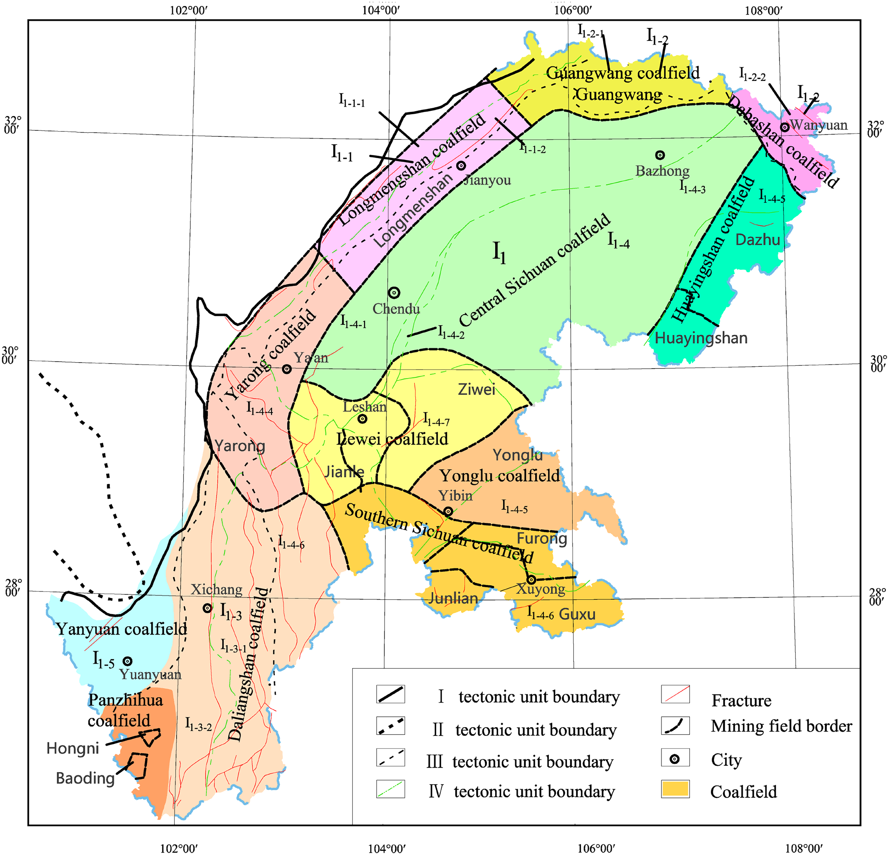
Tectonic units and main coalfields distribution in Sichuan Province (Xu et al., 2015, revised) Class II tectonic unite: I1; Class II tectonic unite: I1-1∼I1-4; Class III tectonic unite: I1-1-1, I1-1-2, I1-2-1, I1-2-2, I1-3-1, I1-3-2, I1-4-1∼ I1-4-1.I1 Upper Yangtze ancient land block; I1-1 Longmenshan foreland thrust belt; I1-1-1 Longmenshan basement nappe zone; I1-1-2 Longmenshan caprock thrust belt; I1-2 Micangshan-Dabashan foreland thrust belt; I1-2-1 Micangshan basement nappe zone; I1-2-2 Dabashan caprock thrust belt; I1-3 Kangdian foreland thrust belt; I1-3-1 Emei-Zhaojue fault basin belt; I1-3-2 Kangdian basement fault uplift zone; I1-4 Sichuan foreland basin; I1-4-1 Western Sichuan piedmont depression basin; I1-4-2 Longquanshan front uplift zone; I1-4-3 Central Sichuan intracontinental depression basin; I1-4-4 Emeishan fault block; I1-4-5 Huayingshan detachment fold belt; I1-4-6 Xuyong-Junlian superimposed fold belt; I1-4-7 Weiyuan uplift; I1-5 Yanyuan-Lijiang thrust belt.
Main coalfields, mining areas and coal rank in Sichuan Province.
Tectonic control law of gas occurrence in Sichuan Province
The coal resources in Sichuan Province are basically distributed in the upper Yangtze block (Figure 1 I1). The formation, deformation, and occurrence of coal bearing basins, including the generation, migration, and preservation of gas are controlled by the formation and development, cracking, subduction collision, and intracontinental orogeny of the Yangtze block. After the Late Permian, the Yangtze region began to enter the period of basin development, which was a transgression and regression process; consequently, coal seams with sea-land alternating facies were formed. Large-scale regression occurred in the Late Triassic, resulting in the formation of coal seams with sea-land alternating facies and land facies in intermountain basins.
During the Indosinian period, the Sichuan Basin was controlled by the orogenic belt on the edge of the basin, and the regional stress field exhibited the state of peripheral compression towards the basin. The upper Yangtze block was subjected to stress in three directions, namely, the compressive torsional stress from west to east generated by the closure of the Tethys ocean and intracontinental compression, the compressive stress from SE to NW generated by the westward subduction of the Pacific plate, and the compressive stress from north to south emerging the Qinling Mountains (Liu et al., 2011; Ren et al., 1980). The stress field intensity dominated by compressive stress and its intensity was weakened from the basin edge to the basin. Consequently, the development degree of tectonic coal was also weakened from the basin edge to the basin.
During the Yanshanian period, the Sichuan block subducted under the Longmen Mountain and affected by the tectonic geological events in the Pacific was mainly characterized by differential uplift and subsidence (Liu et al., 2011; Yan et al., 2003). The mountains around the basin continued to uplift and produced large faults, such as the Longquanshan and Huayingshan faults in the west and east of the basin, respectively. In Eastern Sichuan, the caprock slipped in the Huayingshan-Qiyaoshan area, and the high-steep structural belt superimposed on the Indosinian fold. During this period, the coal bearing strata were squeezed strongly to form folds and faults, resulting in severe damage to the coal body, which is an important formation period of tectonic coal.
During the early Himalayan period, under the influence of the Pacific plate subduction, the NW-SE compressive stress field was generated, forming a series of NE-trending high and steep anticlines. Simultaneously, with the collision and amalgamation of the Indian and Eurasian plates, extensive caprock folds were generated in the west of the upper Yangtze block, forming SN trending fold structures (He et al., 2011; Liu et al., 2000). In the late Himalayan period, the activities of the Xuefeng Mountain on the western edge of the basin weakened, while the Daba Mountain exhibited a relatively strong thrust nappe. The regional stress field was primarily NE-SW; in other words, the basin was subjected to the compressive stress from NE to SW, and a series of NW trending folds and faults were superimposed on the early NE trending structure (Liu et al., 2000). In addition to shaping the internal and marginal structures of the Sichuan basin, the Himalayan movement also further destroyed the coal structure and partially released the shallow gas.
Owing to the different geotectonic locations of every mining area, difference in basin basement properties, caprock, and other boundary conditions, the tectonic movement and evolution may differ, and the strength and direction of in-situ stress may also differ, thereby resulting in different coal seam occurrences, coal body damage degrees, coal metamorphism degrees, and coal adsorption capacities in different mining areas. Even different mines in the same mining area are different. For example, the Panzhihua mining area is located in the middle of Kangdian fault uplift belt (Figure 1 I1−3−2), which is evidently denuded, and there is no good gas caprock, which leads to generally low gas content. The Junlian mining area is located in the north of the middle section of the Xuyong-Junlian superimposed fold belt (Figure 1 I1−4−6). Influenced by folds, the interlayer sliding structures relatively developed, and the structural stress was mainly compression, resulting in the development of class III tectonic coal, high gas content, and severe gas outburst
Gas occurrence characteristics of coal seams in Sichuan Province
Gas occurrence characteristics of the late permian coal seams
The mining areas of Late Permian coal seams mainly include the Furong mining area, Guxu mining area, Junlian mining area of the Southern Sichuan coalfield, and Huayingshan mining area of the Huayingshan coalfield. After the coal seam deposition in the Late Permian, the different coalfields experienced different action intensities of tectonic movements owing to different geotectonic positions, resulting in different gas occurrence. Even if the tectonic positions of different mining areas in the same coalfield are different, the gas occurrence in different mining areas also differs. For example, the shallowest lower boundary of the gas weathering zone and the initial outburst depth in the Furong mining area is 70 m and 103 m, respectively; in addition, those in the Huayingshan mining area is 100 m and 150 m. Gas distribution characteristics of the Late Permian coal seams in the Sichuan Province are presented in Table 2.
Gas occurrence characteristics of the Late Permian coal seams in Sichuan Province.
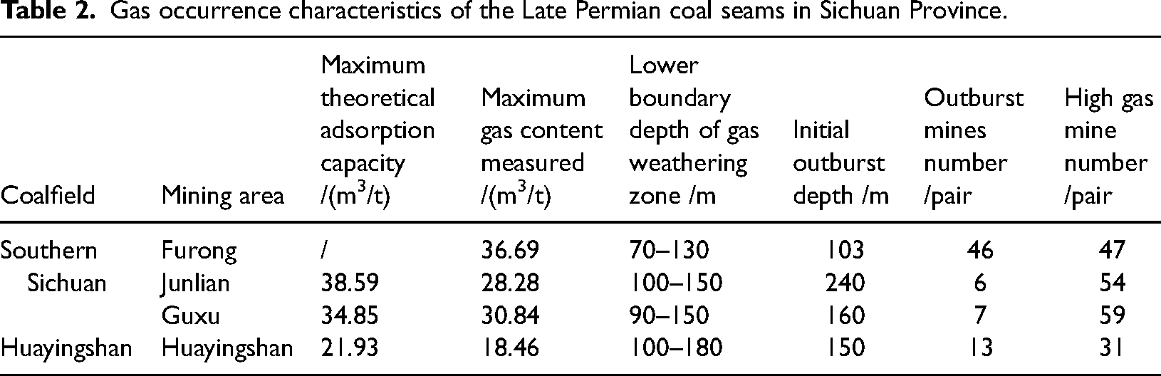
The different metamorphic degrees of coal determine the different production and adsorption capacity of gas, which affects gas occurrence (Farmer and Pooley, 1967; Zhang and Zhang, 1992). The coal rank of the Southern Sichuan coalfield is primarily anthracite, while the coal rank of the Huayingshan coalfield is generally coking coal – lean coal, thus indicating that the gas generation quantity and adsorption capacity of the Southern Sichuan coalfield are higher than that of the Huayingshan coalfield. The average maximum theoretical adsorption capacity of the southern Sichuan coalfield is 38.59 m3/t, while that of the Huayingshan coalfield is 21.93 m3/t. The roof and floor sealing conditions of the two coalfields are relatively good. Therefore, the gas occurrence in the Southern Sichuan coalfield is higher than that in the Huayingshan coalfield.
The distribution characteristics of outburst mines in the Sichuan Province have significant zoning, mainly concentrated in the Xuyong-Junlian superimposed and Huayingshan detachment fold belts. The Late Permian coal seams in the two belts had been under high pressure and strong structural compression for several years, resulting in interlayer sliding and the formation of layered tectonic coal. In addition, the coal metamorphism is high, the gas content is high, and the gas disaster is severe. According to statistics, there are 84 pairs of outburst mines in the province, of which 72 pairs are distributed in the Late Permian coal seams, accounting for 85.7% of the total outburst mines. There are 59 pairs of outburst mines in the Xuyong-Junlian superimposed fold belt, accounting for 70.0%; in addition, the Huayingshan detachment fold belt has 13 pairs of outburst mines, accounting for 14.3%.
The Furong mining area is located in the north of the middle section of Xuyong-Junlian superimposed fold belt, and its main control structure is an NWW-trending Gongchang anticline comprised multiple secondary anticlines and synclines. In addition to the medium-sized faults developed in the secondary fold area near the NW and SE dipping ends of the Gongchang anticline exerting a certain destructive effect on the coal seam, there are no regional faults cutting coal measures strata, which is conducive to gas preservation and is the fundamental reason why Furong mining area is the mining area with the most severe gas disaster in Sichuan Province.
Gas occurrence characteristics of the late triassic coal seams
The occurrence conditions of the Late Triassic coal seams are generally poor in the Sichuan Province. In general, there are several coal seams in the coal bearing strata. The mining coal seams are primarily thin and scattered. The coal metamorphism degree varies significantly. The coal ranks are relatively complete and mainly bituminous coal (refer to Table 1). The gas content of the Late Triassic coal seams is generally lower than that in the Late Permian. The gas grades of 834 pairs of mines mining Late Triassic coal seams were counted, including 9 pairs of outburst mines, 164 pairs of high gas mines, and 661 pairs of low gas mines, account for 79.3%. Gas distribution characteristics of Late Triassic coal seams in Sichuan Province are presented in Table 3.
Gas occurrence characteristics of the Late Triassic coal seams in Sichuan Province.
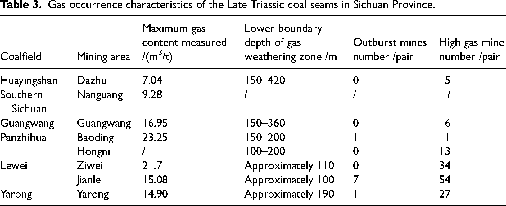
Outburst and high gas mines mining the Late Triassic coal seams are mainly distributed in the Jianle, Ziwei, and Yarong mining areas. In addition, 77.8% of outburst mines and 32.9% of high gas mines are distributed in the Jianle mining area. The Jianle mining area is located in the wide, gentle zone between the Ziwei dome and Emai compound anticline. The geological structure in the area is simple and the faults are not developed, mainly reverse faults. The roof and floor of the main mining coal seams are mostly sandy mudstone or mudstone, which are conducive to gas preservation. The lower boundary depth of gas weathering zone is approximately 100 m, the measured maximum gas content is 15.08 m3/t (Huishan general survey area; buried depth: 553 m), and the maximum gas pressure is 4.27 MPa (Yangcunpu coal mine; buried depth: 500 m). The main control structure of the Ziwei mining area is the Ziwei anticline, with wide, gentle anticline and small dip angle of two wings; in addition, the faults are not developed, mainly reverse faults, which are conducive to gas preservation. The gas content in the mining area is generally high, the maximum gas content measured is 21.70 m3/t (Songfeng general survey area; buried depth: 590 m), and the maximum gas pressure is 4.80 MPa (Songfeng general survey area; buried depth: 471 m). Gas dynamic phenomena occurred at the fold turning end in the Baoding mining area.
Gas occurrence zoning of coal seam in Sichuan Privince
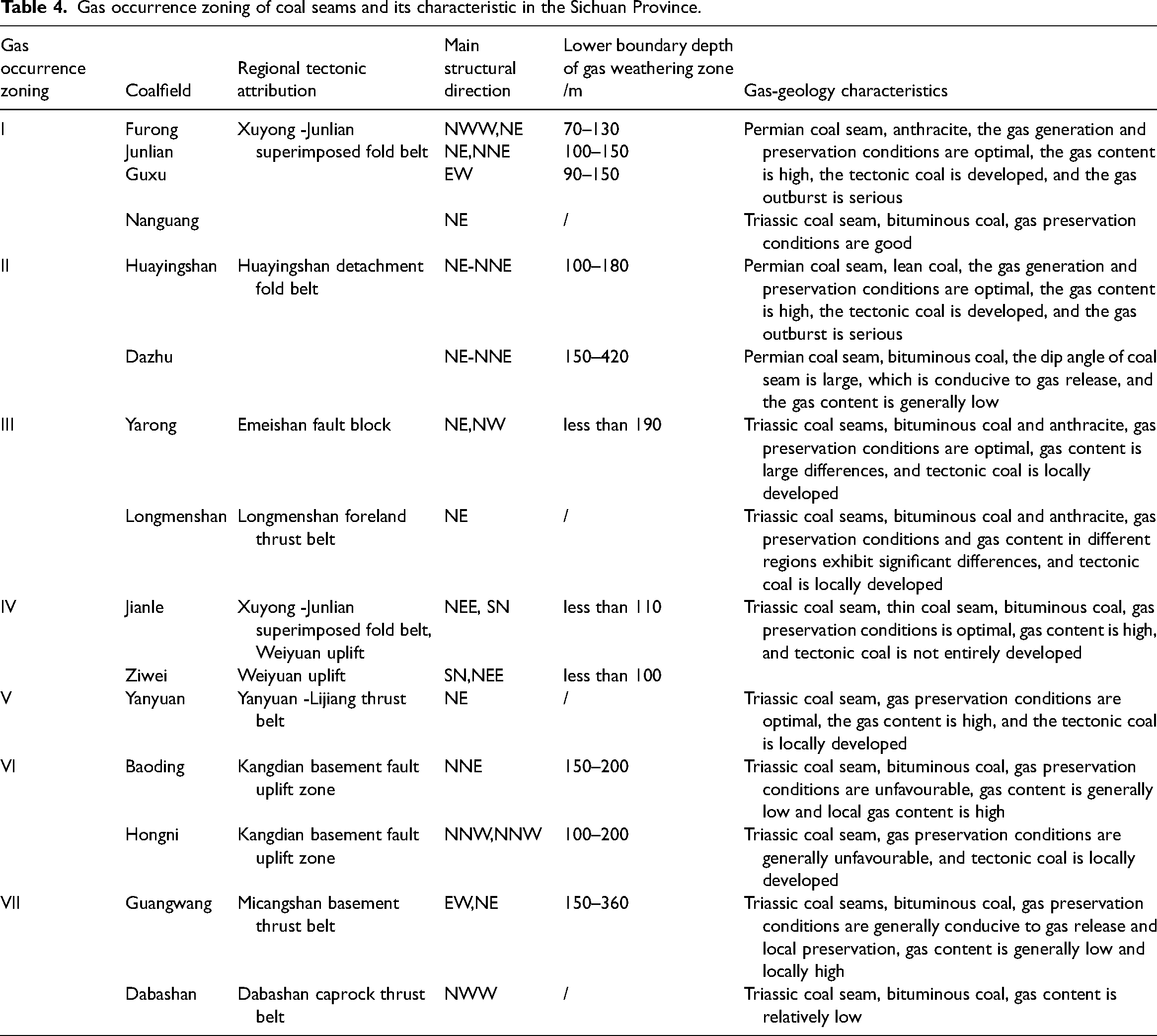
According to the tectonic control law of gas occurrence and the gas occurrence characteristics of coal seams, gas occurrence zones of coal seams in the Sichuan Province were divided into seven gas zones, namely, southern Sichuan superimposed fold high gas and outburst zone, Huayingshan detachment fold high gas and outburst zone, Longmenshan thrust nappe high gas and outburst zone, Ziwei dome high gas zone, Panxi fault high gas zone, Yanyuan arc-like fold high gas zone, and Micangshan-Dabashan thrust low gas zone, as presented in Figure 2 and Table 4.
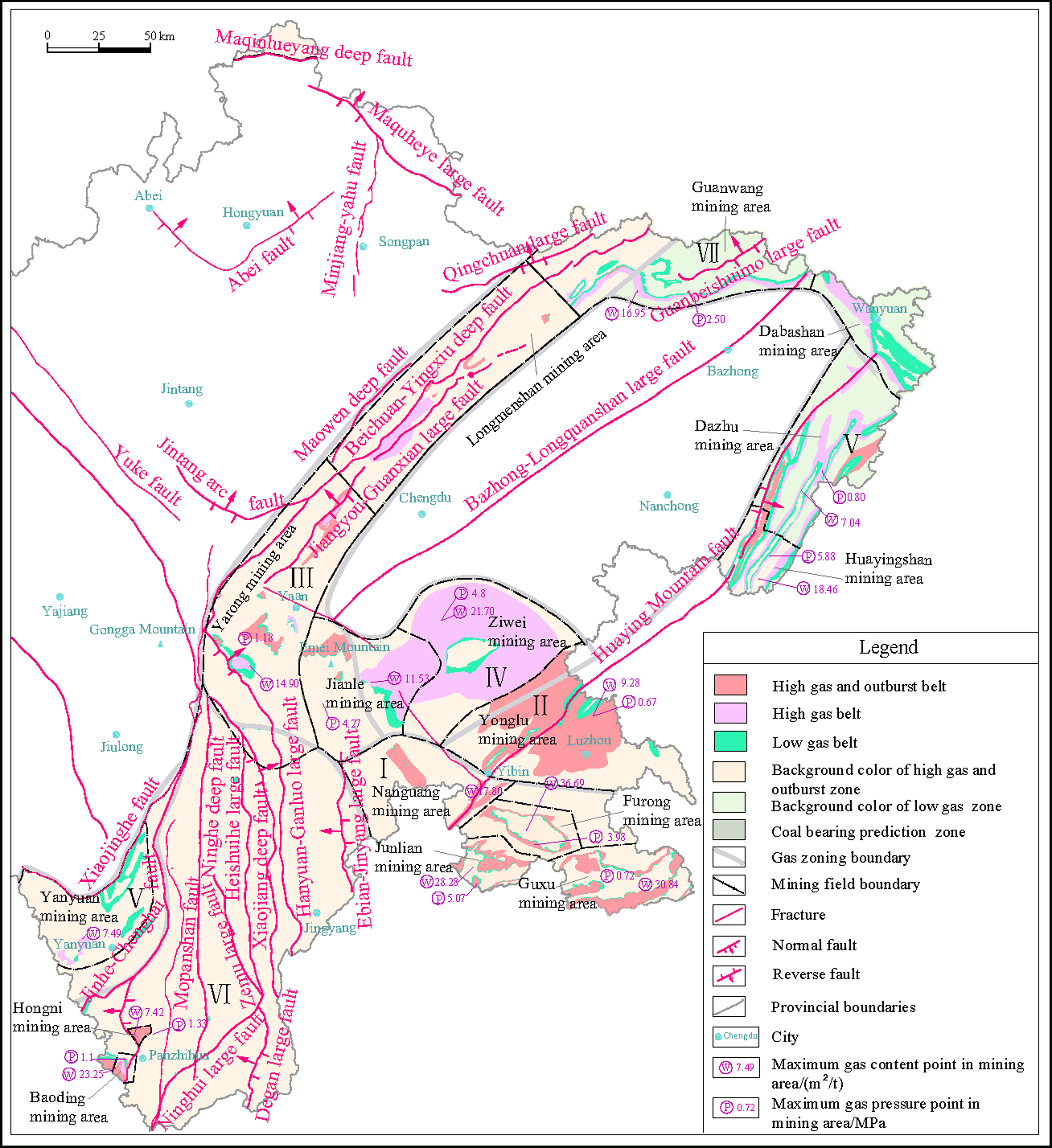
Gas occurrence zoning of coal seams in the Sichuan Province, gas zongs: I Southern Sichuan Superimposed Fold High Gas and Outburst Zone, II Huayingshan Detachment Fold high Gas and Outburst Zone, III Longmenshan Thrust Nappe High Gas and Outburst Zone, IV Ziwei Dome High Gas Zone, V Yanyuan arc-like Fold High Gas Zone, VI Panxi Fault High Gas Zone, VII Micangshan-Dabashan Thrust Low Gas Zone.
Gas occurrence zoning of coal seams and its characteristic in the Sichuan Province.
Southern sichuan superimposed fold high gas and outburst zone I
This zone includes the Guxu, Junlian, Furong, and Nanguang mining areas, as shown in Figure 2. The geological structures formed mainly by Indosinian and Himalayan movements. The third episode of the Indosinian movement generated folding on the edge of the Sichuan foreland basin under the action of north-south compressive stress. During the first episode of the Himalayan movement, the Indian plate collided with the Eurasian ancient plate to the northeast, and the Pacific ancient plate subducted north-westward, thereby strengthening the edge folds. During the second episode of the Himalayan movement, the caprock in this area folded strongly, and the overlying strata thickness of the Late Permian was currently up to more than 6000 m. The region had been under high pressure and strong tectonic compression environment for several years, thereby resulting in high coalification degree, mainly No.3 Anthracite. Until the third episode of the Himalayan movement, the region was still dominated by differential rise, and under the long-term action of various geological forces, the surface suffered strong weathering and denudation, which was conducive for the partial release of gas. This sedimentary environment resulted in high gas content, large gas emission, and severe gas outburst in Furong, Junlian, Guxu and other mining areas in Southern Sichuan coalfield.
Huayingshan detachment fold high gas and outburst zone II
This zone includes the Huayingshan, Dazhu, and Yonglu mining areas, as shown in Figure 2. The coal bearing strata are mainly Late Permian and Late Triassic coal seams. The Late Permian coal seams are mainly distributed in the Huayingshan compound anticline, which generally exhibit the risk of gas outbursts. After the formation of the Permian Longtan group coal measures, and before the late Himalayan period, NNE trending structures in the middle section of Huayingshan were formed under the combined action of NW- and SE-trending horizontal extrusion force and SN counter clockwise torsional force. During the late Himalayan period, the regional stress field changed significantly, and the compressive stress from NE to SW occupied the dominant position, thereby transforming the NNE trending structure. These compressive torsional structures and their composite structures create conditions for the local development of tectonic coal and local accumulation of gas, thus laying the material foundation for gas outburst Owing to the late coal forming age, the gas disaster of the Late Triassic coal seams was relatively light. The dip angle of coal seams in the north of Huayingshan detachment fold belt is large, which is conducive to gas release; in addition, the gas content is relatively low, and the gas grade of the mines is mainly low gas. The dip angle of the coal seams in the south of Huayingshan detachment fold belt are light, the gas content is relatively high, and the gas grade of the mines is mainly high gas. According to the geological structure distribution characteristics and the actual gas emission of coal mining, the Late Triassic coal seams in the north of Huayingshan detachment fold belt was classified as low gas area in the Huayingshan detachment fold high gas and outburst zone.
Longmenshan thrust nappe high gas and outburst zone III
This zone includes the Yarong mining area, northwest of Jianle mining area, and Longmenshan coal bearing area, as shown in Figure 2. The structures in this area are mainly a series of NE-trending thrust nappe structures. The N-S nappe orogeny in Longmen Mountain began in the Indosinian period, and suffered more intense compression in the Himalayan period. The early structures were transformed, the strata were strongly deformed, and the strata continuity and stability were poor. The strong compression created the tectonic coal developed in this area and reduced the threshold of gas outburst It is one of areas with outburst risk of the Late Triassic coal seams in the Sichuan Province.
Ziwei dome high gas zone IV
This zone mainly includes the east of the Ziwei and Jianle mining areas, as shown in Figure 2. The main structures are the Weiyuan dome and Tieshan nose anticlines. The Weiyuan dome anticline was located in the south wing of the Caledonian paleo uplift in Central Sichuan in the early Palaeozoic and in the west slope of Luzhou paleo uplift in the Indosinian period. After multiple structural lateral compressions, it formed huge dome-shaped uplift with flat rock occurrence. The oldest stratum exposed in the dome is the Middle Triassic. Although this area was subjected to multi-stage compressive stresses, the stress was largely released in the fold and fault zone at the basin edge, the structural stress transmitted to the basin was significantly weakened, and the tectonic coal was not developed. Although the gas emission of the mines in this area is large, there have been no gas outbursts or gas dynamic phenomenon to date.
Yanyuan arc-like fold high gas zone V
This zone mainly includes the Yanyuan mining areas, as shown in Figure 2. During the Indosinian movement, this area was significantly affected, resulting in some regional metamorphism of Triassic strata in the north of this area. During the Yanshanian movement, the crust still rose abruptly, resulting in the absence of Jurassic and Cretaceous strata in the west of Jinhe fault. Arc, NE trending, and NNE trending structures in this area were mainly formed after the Indosinian movement, which formed a modern structural pattern based on early SN trending structures. The degree of coal mine exploration and development in this area is low. Tectonic coal is locally developed, and it was predicted that the coal seam gas preservation conditions are optimal.
Panxi fault high gas zone VI
This zone mainly includes the Baoding, Hongni, and Qinghe mining areas, the sporadic coal bearing blocks in the Panxi area, as shown in Figure 2. From the ancient Proterozoic to the end of the Mesozoic period, the Earth's crust had approximately been in the EW direction tension rifting and uplift. The tectonic movement was controlled by deep and large fault activities, exhibiting differential rise and fall. At the end of the Late Triassic, the Indosinian movement caused the Songpan-Ganzi fold to form a mountain, and the micro continental block on the Tethys margin collided with the western margin of the upper Yangtze plate. During the Yanshanian period, the Sichuan block subducted to the west, and the region was subjected to the compressive stress from the southeast direction, thereby forming the prototype of the current structure. Owing to the influence of the Kangdian foreland thrust structure, the gas occurrence in this area is quite different. After the coal bearing strata in the Baoding and Qinghe mining areas, the gas preservation conditions are optimal and the gas content is high. Influenced by tectonic compression, the coal metamorphism degree is high and the tectonic coal is developed in the Hongni mining area. However, owing to the uplift of coal bearing strata, a large amount of gas escaped, and the gas content was low. The sporadic coal bearing blocks in Panxi mining area are generally dominated by uplift, the coal seams are buried shallowly, and gas occurrence is low.
Micangshan-Dabashan thrust low gas zone VII
This zone mainly includes the Guangwang mining area and Dabashan coal bearing area, as shown in Figure 2. In the early Jurassic period, the Yangtze block continued to squeeze northward, the Qinling orogenic belt thrust upward towards the Sichuan Basin, and the Guangwang mining area was under the SN compressive stress environment, thereby forming near EW structural systems. In the middle and late middle Jurassic periods, Sichuan Basin was compressed in the NW-SE direction, resulting in continuous and strong uplift of the basement in this area. The original structure is open, which is conducive to gas escape. In addition, the coal floor of the upper Triassic belongs to the Leikoupo group. Because the gypsum salt layer in the Leikoupo group formed a large number of dissolution caves under the action of the groundwater circulation, the partial collapse of the overlying (coal measure) strata emerged. These factors were conducive for the escape of coal seam gas. According to the gas geological information elucidated by the current coal mining, the gas occurrence of coal seam in this area is low.
Conclusion
Based on the gradual tectonic control theory for gas occurrence and regional tectonic evolution theory, the tectonic control law of gas occurrence was analysed; in addition, the gas occurrence characteristics of the Late Permian and Late Triassic coal seams were discussed. Accordingly, gas occurrence zones of coal seams in the Sichuan Province were divided. The major findings of the study are presented as follows.
The coal resources in the Sichuan Province are basically distributed in the upper Yangtze block. The formation, deformation, and occurrence of coal bearing basins, and the generation, migration, and preservation of gas are controlled by the formation and development, cracking, subduction collision, and intracontinental orogeny of the Yangtze block. The distribution characteristics of outburst mines in Sichuan Province exhibit substantial zoning, and the outburst mines mining Late Permian coal seams account for 85.7% of the total number of outburst mines in the province, of which 70.0% are located in the Xuyong-Junlian superimposed fold belt and 14.3% in the Huayingshan detachment fold belt. In addition, the outburst mines mining Late Triassic coal seams account for 10.7%, are mainly located in the Jianle and Yarong mining areas influenced by the Longmenshan fault zone. The Late Permian coal seams in the Xuyong-Junlian superimposed and Huayingshan detachment fold belts were under high pressure and strong tectonic compression for several years, resulting in interlayer sliding and formation of layered tectonic coal. In addition, the high degree of coal metamorphism and high gas content are the fundamental reasons for the distribution of 84.3% of outburst mines in the Sichuan Province. The Furong mining area is located in the north of the middle section of the Xuyong-Junlian superimposed fold belt. The Gongchang anticline, the main control structure, is a compound short axis anticline comprising multiple secondary anticlines and synclines. NE and NW trending anticlines and synclines were superimposed at the NW and SE dipping ends, respectively. Although the medium faults developed at the two dipping ends exert a certain destructive effect on the coal seam, there are no regional faults cutting coal measures that are conducive to gas preservation, which are the fundamental reasons why the Furong mining area is the mining area with the most severe gas disaster in Sichuan Province. According to the tectonic control law of gas occurrence and gas occurrence characteristics of coal seam, gas occurrence zones in Sichuan Province were divided into seven zones: Southern Sichuan superimposed fold high gas and outburst zone, Huayingshan detachment fold high gas and outburst zone, Longmenshan thrust nappe high gas and outburst zone, Ziwei dome high gas zone, Panxi fault high gas zone, Yanyuan arc-like fold high gas zone, and Micangshan-Dabashan thrust low gas zone; in addition, their tectonic control characteristics and gas occurrence characteristics were analysed.
Footnotes
Declaration of conflicting interests
The author(s) declared no potential conflicts of interest with respect to the research, authorship, and/or publication of this article.
Funding
The author(s) disclosed receipt of the following financial support for the research, authorship, and/or publication of this article: This work was supported by the Key Science and Technology Program of the Henan Province (grant numbers 202102310221, 202102310619, 222102320154), China Postdoctoral Science Foundation (grant number 2021M690916), Key Scientific Research Projects of Colleges and Universities in Henan Province (grant numbers 21A440006, 22A610009), and Doctoral Foundation of Henan Polytechnic University (grant number B2021-5).