
Abstract
Geothermal resources as clean and renewable energy can be utilized for agriculture, tourism, and industry. The assessment of geothermal potential and the study of genetic mechanism of the geothermal system is an essential part of geothermal resource development. In this study, 16 steady-state temperature logs are obtained in the mountainous area on the northern margin of North China. Thermal conductivity and heat production rates are tested or collected from more than 200 rock samples of these wells and outcrops around the study area. Based on these data, for the first time, the detailed delineations of temperature distributions, genetic mechanisms of geothermal systems, and resource potential of Hot Dry Rock in the study area are achieved. The heat flow map indicates a low heat flow state with an average value of 53.1 mW/m2 in the study area, which is lower than the average value of 62.5 mW/m2 in mainland China. The distribution of hot springs in the area is mainly controlled by fault systems. Heat flow only exhibits a minor effect on the temperature of hot springs and geothermal wells. On this basis, the deep temperature distribution within 3–10 km depths of the study area is calculated using the one-dimensional steady-state heat conduction equation. With it, the reservoir depths of hot springs are estimated to be 3–5 km with temperatures ranging from 70°C to 110°C. Furthermore, a conceptual model for the geothermal system in the study area is derived. According to the results, Northeastern Chengde and northern Beijing exhibit the highest temperatures at all depths. Similar patterns are observed in the temperature distribution maps and the heat flow map, which suggest that the deep temperature distribution is mainly controlled by regional heat flow. With the depth increases, the temperature shows larger variation at each depth level, which is possibly caused by the heterogeneity of crustal composition. According to our resource assessment by volumetric method, the exploitable potential of Hot Dry Rock within the depth of 7–10 km of the study area is equivalent to about 3.1 × 10¹¹ tons of standard coal, but the barrier is still existing for development under the current technical and economic conditions.
Introduction
Geothermal resources as renewable energy with enormous potential have received significant attention worldwide in recent years, especially under the goal of diminishing carbon dioxide emissions (Gao et al., 2021; Jacko et al., 2021). North China is a densely populated area that has suffered from severe air pollution (Liu et al., 2020; Poon et al., 2006), thus substantial demand for clean energies exists. Meanwhile, the large potential of geothermal energy is revealed in the area (Hu et al., 2021; Liu et al., 2019; Wang and Lin, 2020). However, previous studies on geothermal resources in North China mainly focused on the resources in the North China Plain (Wang et al., 2018; Zhang et al., 2019), the mountainous area on the northern margin is scarcely studied based on individual boreholes or springs (Shen, 2017). In our study, based on the investigation of geothermal manifestations, borehole temperature, thermal conductivity, and heat production rate of rock samples, the terrestrial heat flow, and deep temperature distribution are analyzed. Accordingly, we present the genetic mechanism analysis of the geothermal system in the mountainous area on the northern margin of North China (NMNC).
Geographically, the NMNC includes the Yanshan Mountains and the Bashang Plateau, with Erlian Basin on the north, Taihang Mountain to the southwest, and North China Plain to the south, the regional average altitude is ∼1500 m (Zhang et al., 2017). A total of 35 sites of hot springs are found in the area, most of which are outcropped near the active fault zones on gneiss and magmatic rocks (Wang et al., 2015). Outlet temperature majorly ranges from 25°C to 90°C, only the Qijia and the Sandaoying springs located on the central-eastern edge of the study area exhibit outlet temperature greater than 90°C (Li et al., 2007; Zhang, 2012). Recently, several geothermal wells are drilled near the hot springs from which the outlet temperature is slightly higher. Medium-low temperature (40–60°C) geothermal resources are also found in the area of inter-mountain basins, for example, in Yanqing (Yuan et al., 2020), Xuanhua, and Kuancheng (Zhang, 2012), the geothermal reservoirs are indicated to be Sinian-Ordovician carbonate rocks.
Regional geological setting
The NMNC is at the junction of Sino-Korean Craton and Inner Mongolia-Greater Xing’an Folding System. It contains three secondary structural units: the Yanshan Fold Belt, the Inner Mongolia Uplift, and the Inner Mongolia Fold Belt which is developed during the late Variscan (Figure 1) (Zhang et al., 2017). The boundaries of these sub-units are deep faults, including the Kangbao-Weichang Fault, the Shangyi-Pingquan Fault, the Shanghuangqi-Wulonggou Fault, etc. These faults and their branches penetrate deep into the crust and may provide channels for deep heat sources.
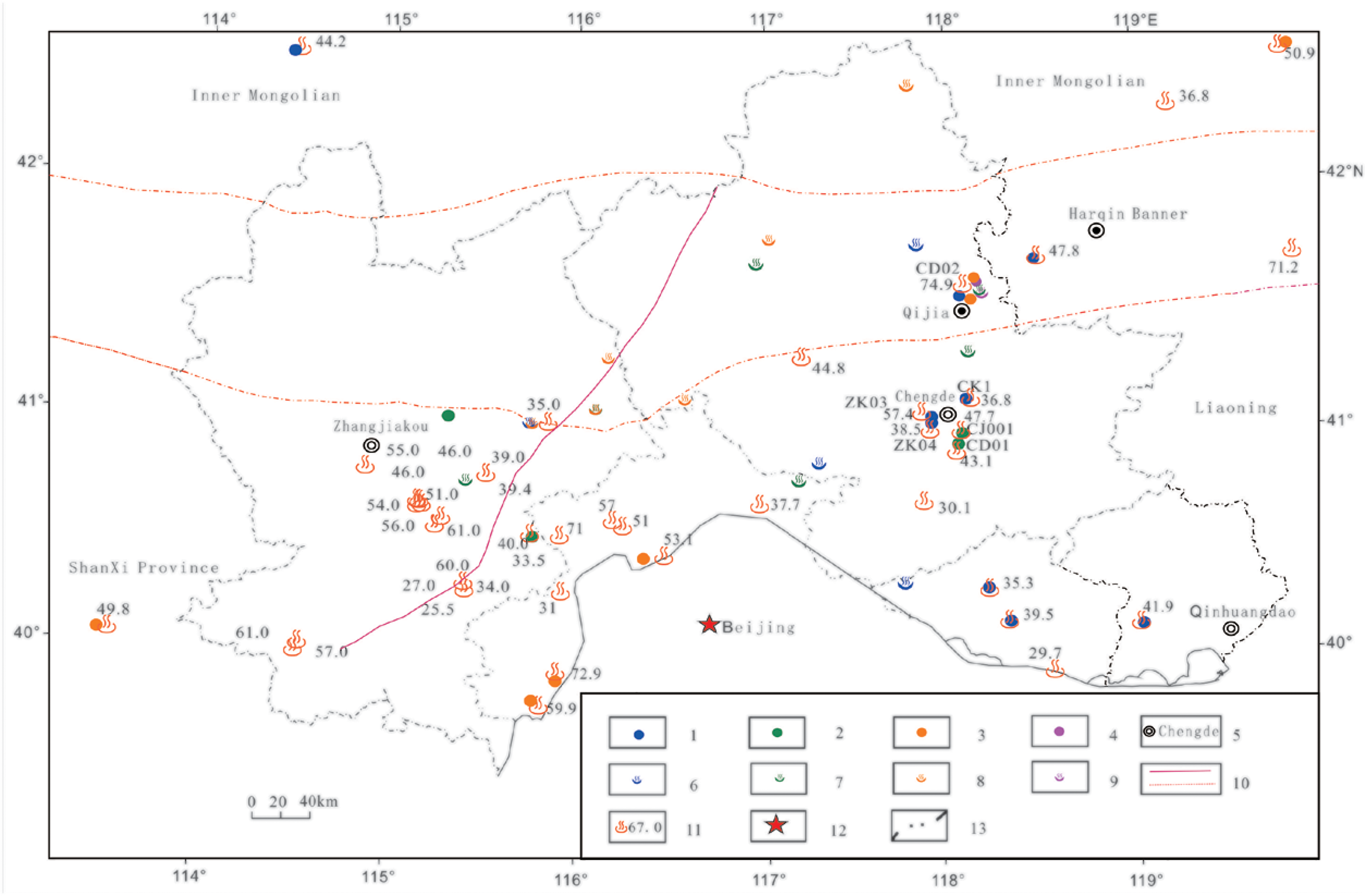
Geographic map of the mountainous area on the northern margin of north China, showing the location of geothermal wells and hot springs. 1 – Geothermal wells (25°C ≤ T < 40°C); 2 – Geothermal wells (40°C ≤T < 60°C); 3 – Geothermal wells (60°C ≤ T < 90°C); 4 – Geothermal wells (90°C ≤ T < 150°C); 5 – City; 6 – Hot springs (25°C ≤ T < 40°C); 7 – Hot springs (40°C ≤ T < 60°C); 8 – Hot springs (60°C ≤ T <90°C); 9 – Hot springs (90°C ≤ T < 150°C); 10 – Faults; 11 – Heat flow sites (values in mW/m2); 12 – Capital; 13 – Administrative boundary.
The strata in the study area include Archean, Mesoproterozoic, Permian, Jurassic, Cretaceous, and Neogene formations. Among them, Neogene and Quaternary formations are unconsolidated sediments containing sand, gravel, and clay, which are deposited in sporadic inter-mountain basins. Other strata are widely distributed throughout the study area, but the lithology and thickness vary in different regions. The Archean stratum is mainly gneiss, the Mesoproterozoic formations contain dolomite and sandstone, and the Mesozoic formations are composed of tuff, andesite, breccia, and other volcanic rocks. Magmatic activities are periodic and extensive in the area, resulting in multi-stage granitoid intrusions (Lin, 2019), which are rarely observed in the North China Plain and Taihang Mountains to the south.
The crust of NMMC is thicker than that of the North China Plain (28–37 km) (Jia et al., 2006), the Moho depths beneath NMNC range from 33 to 45 km (Liu et al., 2020; Xiong et al., 2011). Taking the VP = 6.0 km/s as the bottom interface of the bedrock in the area (Jia et al., 2009) the buried depth of the basement is about 5–11 km, but the eastern and western parts vary significantly. The basement is composed of Archean gneiss and multi-stage granite, underneath which is the upper crust constituted of granite.
Data and method
Temperature logging
A majority of the boreholes in the mountainous area of NMNC are with depths less than 500 m. However, with the increasing demand for clean energies, exploration and exploitation for geothermal resources boost recently, as a result, the amount of deeper drilling has been increasing. Compared with shallower boreholes, these deep boreholes penetrate older formations, among which most of them exhibit linear conductive temperature curves in a large range of depths (Figure 2). Based on these temperature data from deeper boreholes, the impact on geothermal gradients from the convection at shallow depths can be reduced, and the quality of the heat flow in the area could be improved. Furthermore, the deep temperature distribution and genetic mechanism of the regional geothermal system can be discussed.
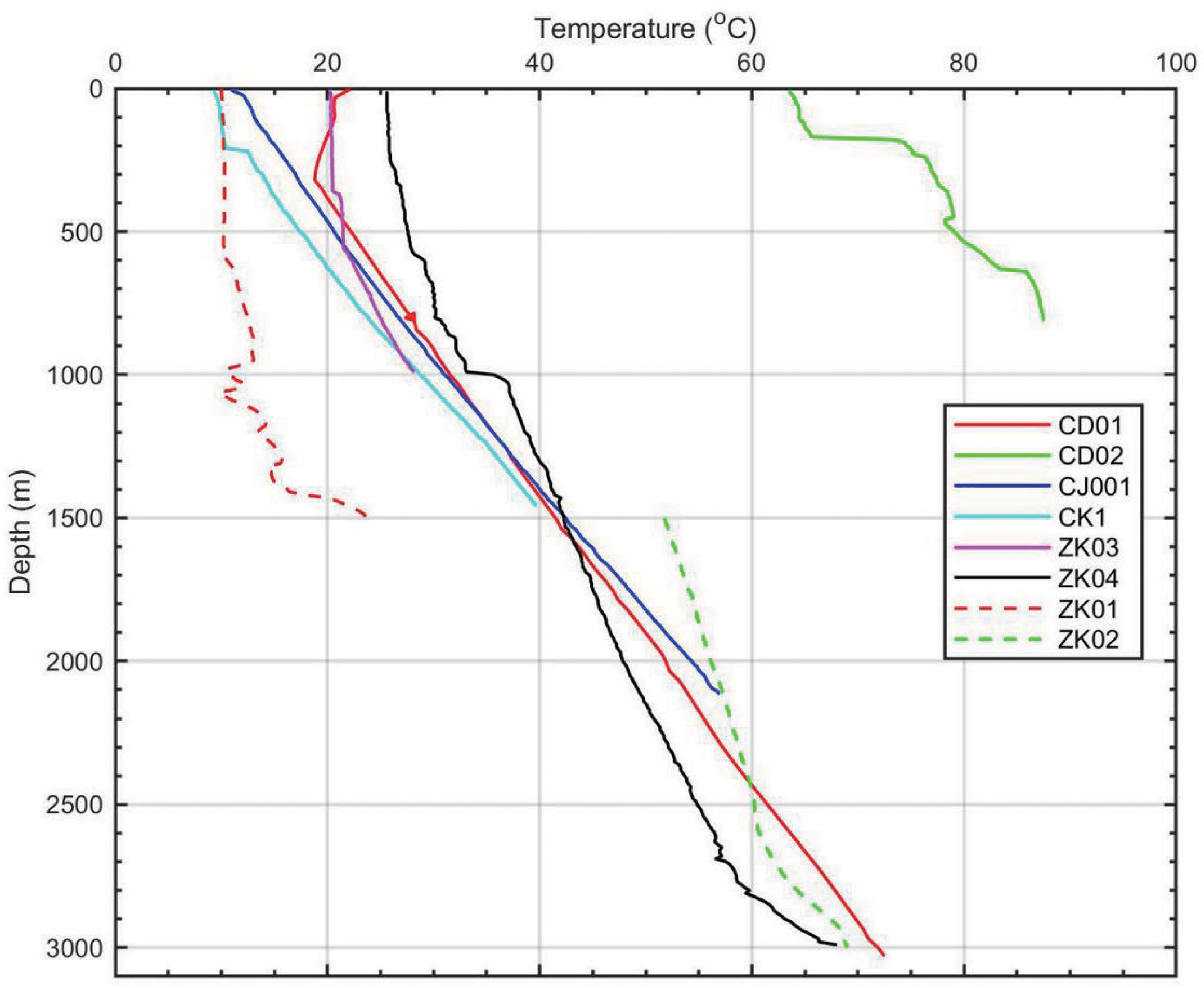
Temperature logs of the deep wells in mountainous area on the northern margin of north China.
Through borehole temperature logging and data collection, a total of 16 sets of temperature data from deep wells (depth >500 m) are obtained, with bottom depths of 600–3400 m. The sites of temperature logging are mostly concentrated within the Chengde City (Figure 2), the Well CD01 having the largest temperature logging depth (Figure 3). In our study, the well temperature is measured using SKD-3000B logging system or the TH212 thermometer, with a temperature measurement range of 0–350°C. The system allows temperature recording with 0.01°C sensitivity and 0.1°C accuracy. To ensure the borehole temperature recover to a steady-state or quasi-steady-state (He et al., 2008), the temperature measurements were taken more than 96 h after the drilling process finished.
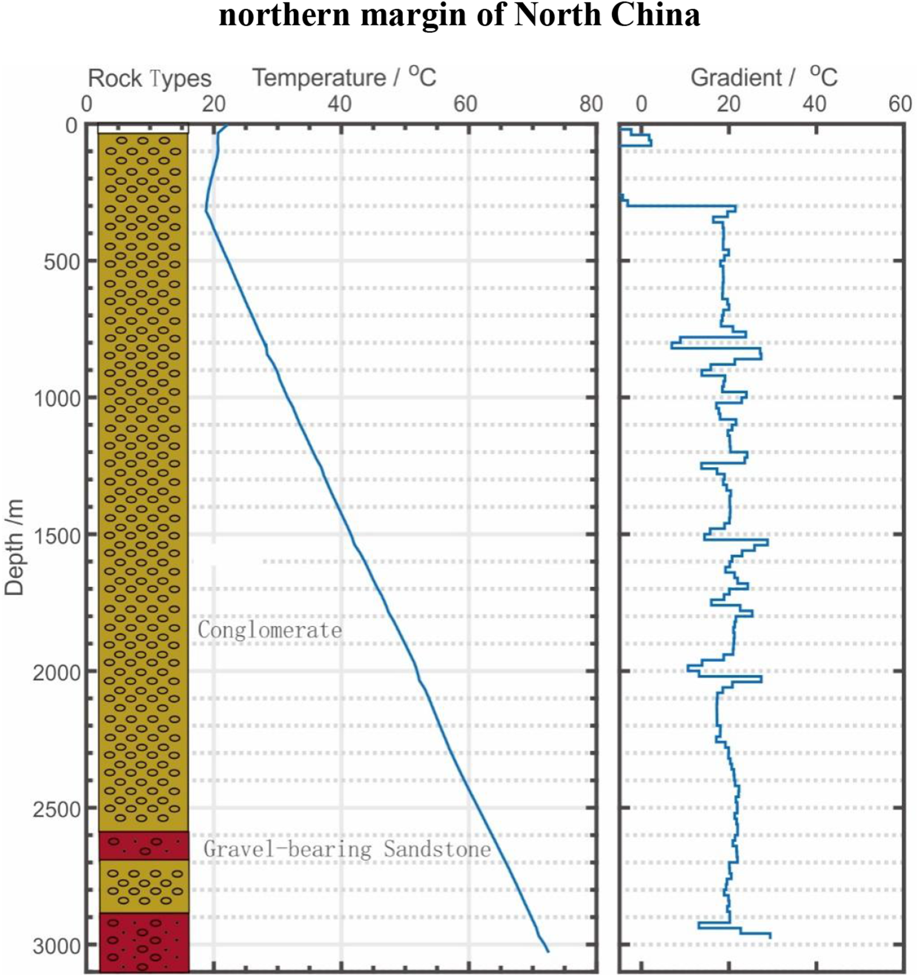
Temperature and temperature gradients versus depths in Well CD01. Note: The legend numbers are the same as Figure 1.
Thermal conductivity and heat production
Rock thermal conductivity and heat production are analyzed with the samples collected in Chengde, Zhangjiakou, Tangshan, Qinhuangdao, and other areas. The data of thermal conductivity and heat production of rock samples in northern Beijing were collected (Lei et al., 2018a). The TCS (thermal conductivity scanning) system manufactured by Lippmann and Rauen GbR, Germany is used for the measurements of the thermal conductivity. The accuracy and range for the device are ± 3% and 0.2–25.0 W/(m K), respectively. The heat production is calculated by measuring the contents of Uranium (U), Thorium (Th), and Potassium (K) in rocks and the density (Rybach, 1976). In this work, U and Th were determined by the ICP-MS system with an uncertainty of ± 1% to ± 10%. The K element was determined by the XRF method, and the uncertainty was ± 1% to ± 2%. The density is determined using the volume ring gauge method with an accuracy of 0.002 g/cm3 and an uncertainty of less than 1%. The representative column of thermal conductivity and heat production for the eastern and western parts of the study area are established, respectively, as shown in Tables 1 and 2. The measured thermal conductivities are corrected according to equations (1) and (2) (Gong et al., 2011; Sass et al., 1992), except for the upper crust


Thermal conductivity column of the eastern parts of mountainous area on the northern margin of north China.
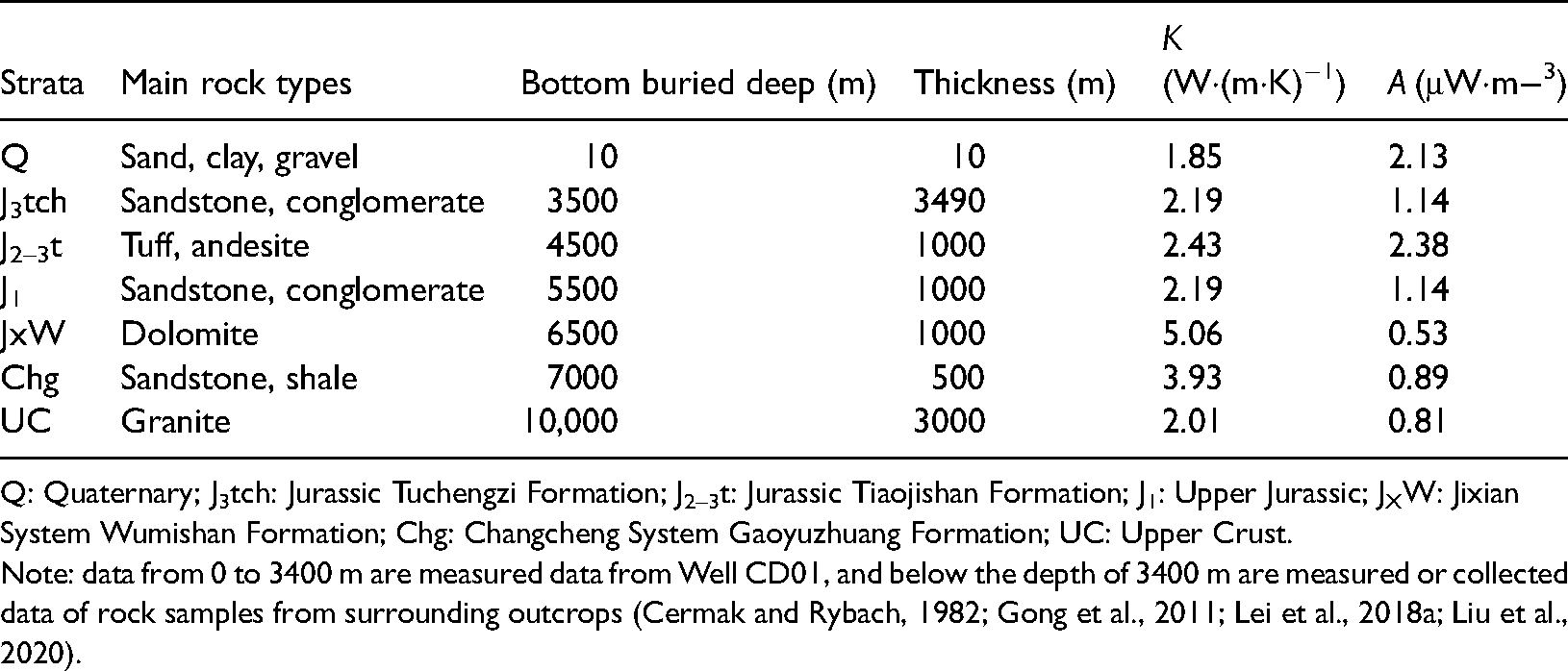
Q: Quaternary; J3tch: Jurassic Tuchengzi Formation; J2–3t: Jurassic Tiaojishan Formation; J1: Upper Jurassic; JXW: Jixian System Wumishan Formation; Chg: Changcheng System Gaoyuzhuang Formation; UC: Upper Crust.
Note: data from 0 to 3400 m are measured data from Well CD01, and below the depth of 3400 m are measured or collected data of rock samples from surrounding outcrops (Cermak and Rybach, 1982; Gong et al., 2011; Lei et al., 2018a; Liu et al., 2020).
Thermal conductivity column of the western parts of mountainous area on the northern margin of north China.
Q + N: Quaternary and Tertiary; J3Z: Jurassic Zhangjiakou Formation; γ: Granite intrusion; UC: Upper Crust.
Note: data from 0 to 3000 m are measured data from Well ZK02; other data are from the same sources as Table 2.
Determination of deep temperature distribution
The temperature field at depth is a reflection of the regional thermal state, and also an important parameter to evaluate the geothermal potential at different depths. Based on the computed reservoir temperature of hot springs, the depth to the geothermal reservoir of the area can be estimated. Moreover, the genetic mechanism and a conceptual model for the geothermal system can be proposed.
The temperature within the part of the crust in the depth range of drilled wells can be directly measured, while that of the deeper part can only be inferred by indirect approaches. In our study, the deep temperature field is calculated by the one-dimensional steady-state heat conduction equation (Lachenbruch, 1970):
The calculation is started at the depth of the zone of constant temperature, and the temperature at the zone of constant temperature is taken as T0 for the first calculating interval (Jiang et al., 2016a). The depth of the zone is about 15–20 m (Wang et al., 2012), and the temperature is 7.3–11.6°C (Liu et al., 2020; Sun et al., 2020), which gradually increases from north to south.
Volumetric method for resource assessment of hot dry rock
Based on the computed result of temperature distribution at depth, the volumetric method could be applied to assess the total amount of the Hot Dry Rock (HDR) resources within the deep strata with low permeability and porosity in the study area, via the equation of
Results and discussion
Regional distribution of heat flow
In our study, 15 heat flow data are determined based on the measured and collected temperature measurements and thermal conductivity (Figure 1, for details please see Liu et al. (in preparation)), and 55 sets of heat flow data within the area and surrounding areas are compiled from Jiang et al., (2016b); Lei et al., (2018a) and Liu et al., (2020). In a total of 70 heat flow data, 40 of them fulfill the criteria for Category A and 19 belong to Category B. The high-quality data (>B) account for more than 80% and are evenly distributed (Figure 1). Thus, the result could represent the thermal state of the area (Zhang, 2012).
According to the data, the average heat flow of the mountainous area of NMNC is 51.3 mW/m2, which is less than the global continental average of 65 mW/m2 (Pollack et al., 1993) and the average value of 62.5 mW/m2 in continental China (Hu and Huang, 2015; Jiang et al., 2016b), indicating that the NMNC has a low heat flow state (Figure 4). However, locally high heat flow is observed in the region of Qijia-Maojingba in the northeast of Chengde City and in the region of Yanqing in the north of Beijing, with the highest values greater than 70 mW/m2. The representative geothermal fields are developed in the two areas, respectively, both have outlet water temperature >60°C, which are the highest in NMNC, indicating the impact of high heat flow. Nevertheless, the heat flow in other regions of the study area is lower than 50 mW/m2 in general, and the outlet temperature is in the range of 25–60°C. It is speculated that the geothermal resources in the area are fault-controlled.
Reservoir temperature and reservoir depth of the hot springs in the mountainous area on the northern margin of north China.
Deep temperature distribution
Since most of the boreholes in the studying area are less than 3000 m deep, the temperature distribution at a depth greater than 3000 m is extrapolated using equations (1) and (2). In the calculation, for boreholes in the western part, including the areas of Beijing, Zhangjiakou, and the Shanxi Province, the thermophysical parameters in Table 2 are employed; for the eastern part, thermophysical parameters are taken from Table 1. In the region of northern Zhangjiakou without a borehole, data from the study of deep temperature distribution of continental China is adopted (Wang et al., 2012).
The calculated results are shown in Figure 5, where Figure 5(a) to (d) are temperature distribution at the depth of 3, 5, 7, and 10 km, respectively. Similar characteristics are observed in the temperature distribution maps at different depths: the northeastern part of Chengde is the region with the highest temperature, followed by northern Beijing. Low values are found in the north of Tangshan-Qinhuangdao region and the northern part of Zhangjiakou, the temperature in Zhangjiakou and central-southern Chengde are close to the regional average. The distribution of temperature at depths correlates well with surface heat flow distribution.
Temperature distribution at selected depth levels (3–10 km) of the mountainous area on the northern margin of north China: (a) depth = 3 km; (b) depth = 5 km; (c) depth = 7 km; (d) depth = 10 km.
Meanwhile, according to the temperature maps, at 3 km depth, the temperature in the mountainous area of NMNC is between 60°C and 80°C, at 5 km depth the temperature ranges from 90°C to 130°C, at 7 km depth it varies between 90°C and 180°C, and at 10 km depth the temperature increases to 160–270°C.
As the depth increases, the range of variation of temperature at the same depth level gradually increases, which is possibly caused by the superimposed effect of the variation of heat flow in different regions and the heterogeneity of crustal composition.
Based on the result, in the mountainous area of NMNC, regions with the temperature of ≥150°C are shown at the depths of 7–10 km in the Yanqing of Beijing and the Qijia-Maojingba of Chengde, which indicate that these regions have the potential for the development of HDR.
Conceptual model for the geothermal system
The hydrochemical thermometers indicate that except for the Taiziquan spring, the deep reservoir temperatures of the hot springs in the study area are in the range of 70–110°C, with an average of 88°C (Liu, 2006; Shen, 2017; Zhang, 2012). In the previous studies, the calculated results of reservoir temperature of Hongtangsi spring and Tangzimiao spring are similar in Zhang (2012) and Shen (2017), which are close to the minimum value obtained by Liu (2006). Thus, for our study, the average value of reservoir temperature from Zhang (2012) and Shen (2017), and the minimum value from Liu (2006) are taken to obtain a correlation between reservoir temperature and temperature distribution at depths as shown in Table 3.
Through the correlation between the reservoir temperature and the temperature field at depths, the geothermal reservoir depths in the mountainous area of NMNC are estimated (Figure 5, Table 3). It can be inferred that most of the geothermal reservoirs in the study area are at depths of 3–5 km, with an average of 4.2 km. This result shows greater geothermal reservoir depth than that from previous studies (2–4 km) which are obtained by assuming a constant temperature gradient of 30°C/km (Shen, 2017; Zhang, 2012). According to our results, the derived temperature gradient within 0–5 km is approximately <25°C/km. The low-temperature gradient is according to the low heat flow state (with an average of 51.3 mW/m2) and relatively high thermal conductivities (>2 W/m·K) in the area.
Besides, the overall trends of the calculated results by the two approaches are similar, with a difference of about 1.4 km (Figure 6), indicating that the deviation is mainly resulted from the variation of temperature gradients. The majority of mountainous areas in China exhibit a low heat flow state and high thermal conductivity of basement rocks (Jiang et al., 2019), thus the assumption of a constant temperature gradient of 30°C/km in the calculation of geothermal reservoir depth is inappropriate. Regional geothermal background and thermophysical parameters of strata should be case-by-case analyzed in detail to give better guidance for the exploration and exploitation of geothermal resources in mountainous areas of China.
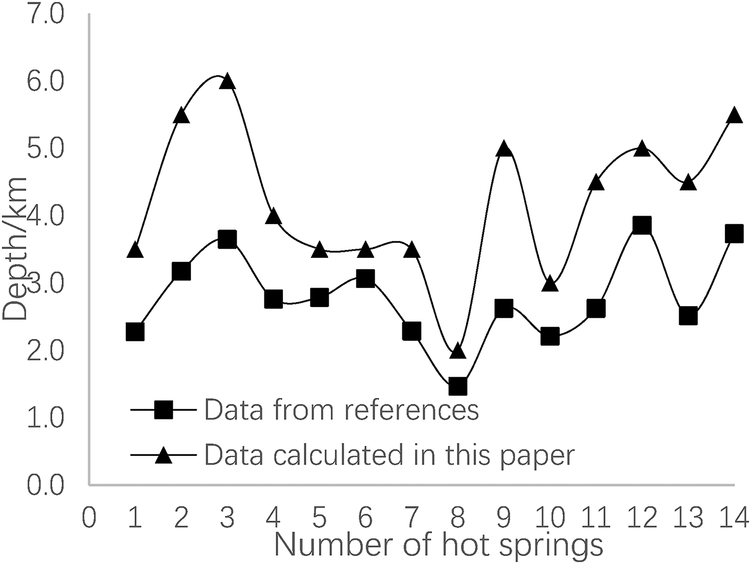
Comparison of the geothermal reservoir depths calculated by two different approaches.
The genetic mechanism and the corresponding conceptual model of the geothermal system in the research area are proposed. As illustrated in Figures 6 and 7, the temperature in the reservoir of the convective geothermal system in the area is between 70°C and 110°C with depths of 3–5 km. Thus, the main mechanism for the formation of the geothermal system in the study area is a deep circulation of groundwater. The water-conducted faults may penetrate a depth of 3–5 km, recharging low-temperature groundwater flows through the faults to the deep geothermal reservoir, and after heated up it rises by convection and mixes with recharging fluid near the surface or expose at surface forming hot springs. The distribution of hot springs correlates well with the distribution of faults, while the temperature of hot springs is affected by regional heat flow.
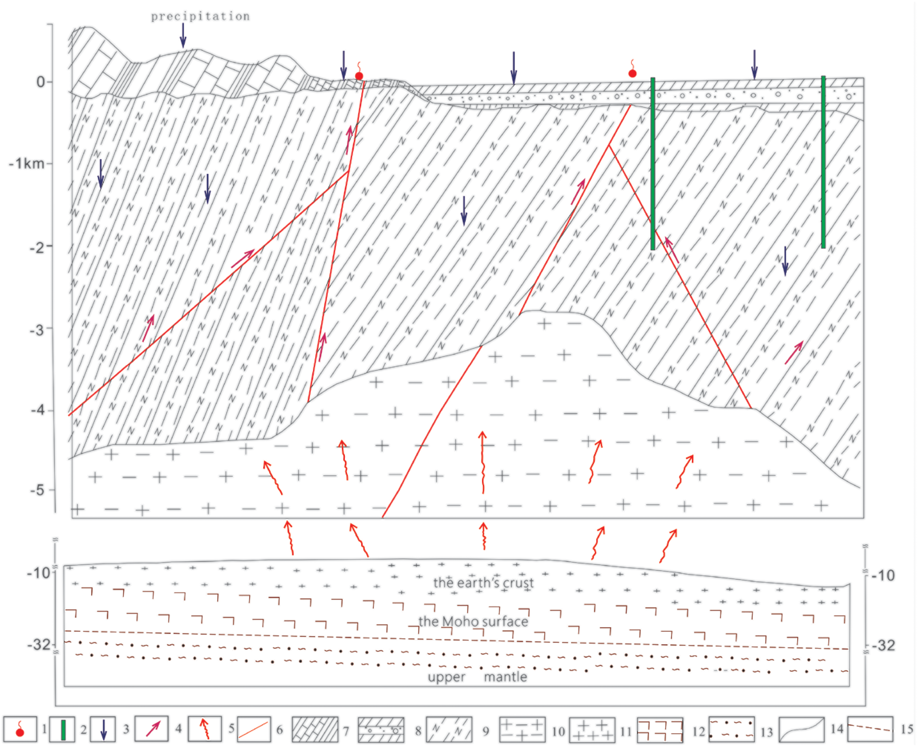
Conceptual model of mountainous type geothermal system on the northern margin of north China. 1 – Hot spring; 2 – Geothermal well; 3 – Infiltration of cold water; 4 – Upwelling of hot water; 5 – Heat flow; 6 – Faults; 7 – Bedrock weathered shell; 8 – Cenozoic sedimentary cover; 9 – Bedrock; 10 – Archean basement; 10 – SIAL; 11 – SIMA; 12 – Mantle materials; 14 – Stratigraphic boundary; 15 – Moho surface.
The intermountain basins are mainly in the southern part of the study area, including the Kuancheng Basin, Yanheying Basin, and Zunhua Basin in the southeast, the Yanqing Basin in the south, and the Zhangjiakou Basin and Xuanhua-Huilai Basin in the southwest Under the impact of conductive heat transfer, the temperature at depth >2 km is commonly greater than 40°C, and the temperature at depths >3 km is generally greater than 60°C (Figure 5). Thick carbonate aquifers of the Jixian System and the Changcheng System are found in most of these basins. The reservoir temperature increases with the increase of the buried depth of the aquifers. Such conductive geothermal resources can only be acquired through geothermal well drilling.
Resource assessment of HDR
The previous assessment of geothermal resources in the mountainous area on the NMNC mainly focuses on the shallow hydrothermal system, the resource potential of deep HDR has not been studied. Globally, 150°C is taken as the lower limit of temperature for HDR resources (Olasolo et al., 2016; Rybach et al., 1978). As shown in Figure 5, the shallowest depth of 150°C isotherm in the study area is 7 km. With the limitation of current drilling technology and the economically exploitable depth of geothermal resources, the maximum depth for HDR resources is 10 km (Wang et al., 2012). Therefore, in a depth range of 7–10 km, the volumetric method (equation (4)) is used to assess the resources of HDR in the study area.
The average temperature at the constant temperature layer in the study area is about 9.5°C (Liu et al., 2020; Sun et al., 2020). As shown in Tables 1 and 2, the lithology at the depth range of 7–10 km is granite, with an average density of 2.60 × 10³ kg/m3 and an average heat capacity of 0.63 kJ/(kg·K) (Lei et al., 2018b). The assessment area is about 95,700 km2. The total volume at 7–10 km depth of the area is divided into 1 km × 1 km × 0.1 km computing units, and the temperature of each unit is determined based on deep temperature distribution (Figure 5). At 7 km depth, the area with the temperature greater than 150°C is about 1800 km2; at 8 km depth, the area with the temperature greater than 150°C is about 47,000 km2; at depths of 9–10 km, the whole study area is with a temperature greater than 150°C (Figure 5).
Based on the calculation using data above, the resource potential for HDR at depths of 7–8, 8–9, and 9–10 km are 0.35 × 10¹⁹, 1.67 × 10¹⁹, and 2.51 × 10¹⁹ kJ, respectively, with a total of 4.53 × 10¹⁹ kJ. Taking recoverable ratio as 20% (Jiang et al., 2016a), the recoverable resources of HDR in the study area are 9.05 × 10¹⁸ kJ, which is equivalent to 3.1 × 10¹¹ t standard coal (1 ton 7 of standard coal is equivalent to 2.93 × 10⁷ J).
Conclusions
Based on 15 obtained terrestrial heat flow data and 55 collected terrestrial heat flow data, the distribution of heat flow in the mountainous area on the NMNC is mapped. The heat flow map indicates a low heat flow state with an average value of 53.1 mW/m2 in the study area, which is lower than the average value of 62.5 mW/m2 in mainland China. Heat flow only exhibits a minor effect on the temperature distribution of hot springs and geothermal wells. The majority of the hot springs are found along the deep faults, indicating that the geothermal resources in the area are fault-controlled.
Based on the heat flow map and the thermal-physical parameters of the strata, the deep temperature distribution within 3–10 km depths of the study area is calculated using the one-dimensional steady-state heat conduction equation. The result shows that at all depth levels, the highest temperatures are always observed in the Qijia-Maojingba region in the northeast of Chengde and the Yanqing region in the north of Beijing. Similar patterns observed in the temperature distribution maps and the heat flow map suggests that the deep temperature distribution is mainly determined by heat flow. The variation of temperature at each depth level gradually increases with the depth increasing, which is possibly caused by the heterogeneity of crustal compositions.
According to the deep temperature distribution and the calculated results of reservoir temperature of hot springs, the genetic mechanism of the regional geothermal system is analyzed. The reservoir depths of hot springs are estimated to be 3–5 km with reservoir temperature ranging from 70°C to 110°C. For geothermal resources in the intermountain basins, the main reservoirs are carbonate rocks of the Jixian System and the Changcheng System with reservoir temperature ranging from 50°C to 80°C. Based on the analysis, the exploration of geothermal resources in the mountainous area should focus on water-conducted faults near hot springs. And the drilling target is suggested to be within the depth of 5 km. In the intermountain basins, it is necessary to utilize geophysical data to locate aquifers within the depth range of 2–5 km.
Below the depth of 7 km, the rock temperature reaches 150°C. According to the resource assessment by volumetric method, the exploitable resource of HDR within the depth range of 7–10 km in the study area is 1.34 × 10¹⁹ kJ, which is equivalent to 3.1 × 10¹¹ t standard coal. However, due to the depth of HDR resources is greater than 7 km in the area, the barrier is still existing for development under current technical and economic conditions.
Footnotes
Declaration of conflicting interests
The authors declared no potential conflicts of interest with respect to the research, authorship, and/or publication of this article.
Funding
The authors disclosed receipt of the following financial support for the research, authorship, and/or publication of this article: This study was financially supported by grants from the geothermal survey project of China Geological Survey (grant no. DD20190128, DD20160190), Key Research and Development Program of Jiangxi Province (grant no. 20203BBG72W011) and National Natural Science Foundation of China (no. 41402231).